Navigation Systems. 1. The Chart Supplement provides a listing of available VOR receiver ground checkpoints and VOTs (VOR receiver test facilities).
|
|
|
- Mary Townsend
- 6 years ago
- Views:
Transcription
1 Navigation Systems 3.1 DISTANCE MEASURING EQUIPMENT (DME) 1. DME displays slant range distance in nautical miles. 2. Ignore slant range error if the airplane is 1 NM or more from the ground facility for each 1,000 ft. AGL. a. The greatest slant range error comes at high altitudes very close to the VORTAC. b. EXAMPLE: If you are 6,000 ft. AGL directly above a VORTAC, your DME will read 1.0 NM. 3.2 VOR RECEIVER CHECK 1. The Chart Supplement provides a listing of available VOR receiver ground checkpoints and VOTs (VOR receiver test facilities). 2. Over airborne checkpoints designated by the FAA, the maximum permissible bearing error for the VOR receiver is plus or minus 6 of the designated radial. a. An alternative to a certified airborne checkpoint is a prominent ground reference point that is more than 20 NM from a VOR station that is along an established VOR airway. 1) Once over this point with the Col needle centered, the OBS should indicate plus or minus 6 of the published radial. 3. The maximum difference between two indicators of a dual VOR system is 4 between the two indicated bearings to the VOR. a. The Col needles should be centered and the indicated bearings checked rather than setting to identical radials and looking at the Col needles. 4. VOTs are available at a specified frequency at certain airports. The facility permits you to check the accuracy of your VOR receiver while you are on the ground. a. The VOT transmits only the 360 radial in all directions. b. Tune the VOR receiver to the specified frequency, and turn the OBS (omnibearing /selector) to select an omnibearing course of either 0 or ) The COI needle should be centered; if not, then center the needle. 2) If 0, the TO/FROM indicator should indicate FROM. 3) If 180, the TO/FROM indicator should indicate TO. 4) The maximum error is plus or minus When making a VOR receiver check with your airplane located on the designated ground checkpoint, the designated radial should be set on the OBS. a. The CDI must center within plus or minus 4 of that radial with a FROM indication.
2 3.3 VERY HIGH FREQUENCY OMNIDIRECTIONAL RANGE (VOR) STATION 1. When VORs are undergoing maintenance, the coded and/or voice identification is not broadcast from the VOR. 2. OMEITACAN coded identification is transmitted one time for each three or four times the VOR identification is transmitted. a. If the VOR is out of service, the OME identification will be transmitted about once every 30 seconds at 1350 Hz. 3. A full-scale (from the center position to either side of the dial) deflection of a VOR CDI indicates a 10 deviation from the course centerline. a. About 10 to 12 of change of the OBS setting should deflect the COI from the center to the last dot. 4. An (H) Class VORTAC facility has a range of 40 NM from 1,000 ft. AGL to 14,500 ft. AGL, and a range of 100 NM from 14,500 ft. AGL to 18,000 ft. a. To use (H) Class VORTAC facilities to define a direct route of flight at 17,000 ft. MSL, the facilities should be no farther apart than 200 NM. b. Generally, for IFR operation off of established airways below 18,000 ft., VOR navigational aids should be no more than 80 NM apart. 5. VOR station passage is indicated by a complete reversal of the TO/FROM indicator. a. If after station passage the CDI shows a 1/2-scale deflection and remains constant for a period of time, you are flying away from the selected radial. 6. Airplane displacement from a course is approximately 200 ft. per dot per NM on VORs. a. At 30 NM out, one dot is 1 NM displacement; two dots, 2 NM. b. At 60 NM out, one dot is 2 NM displacement; two dots, 4 NM. 7. Time/distance to station formula. When tracking inbound, make a 90 turn and measure time and degrees of bearing change x Min. between bearings a. Min. to station = Degrees of bearing change.. TAS x Min. between bearings b. Distance to station = Degrees of bearing change 1) You may also use your flight computer to calculate the distance.
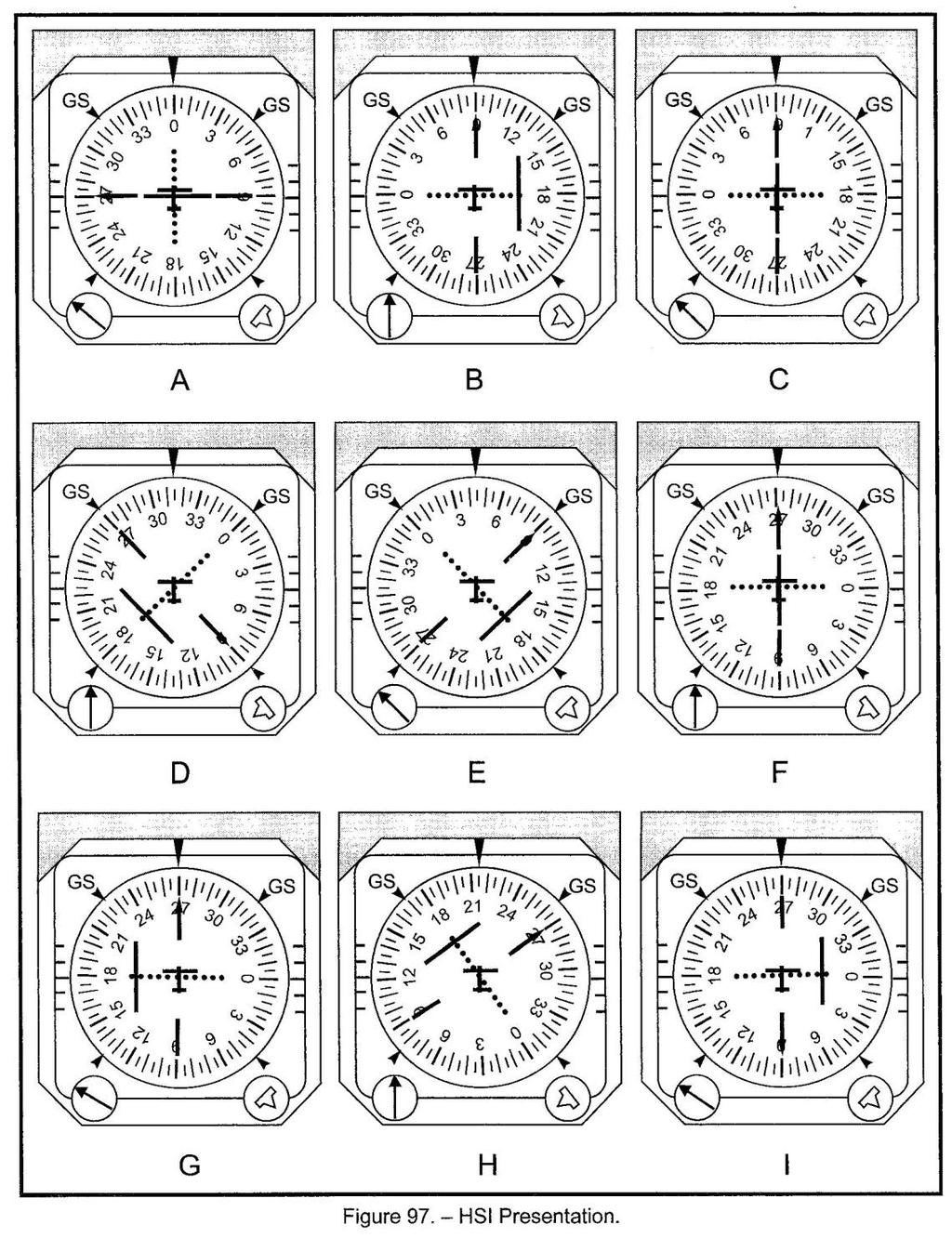
3 3.4 HORIZONTAL SITUATION INDICATOR (HSI) 1. The horizontal situation indicator (HSI) is a combination of the heading indicator and the VOR/ILS indicator, as illustrated and explained below. a. The azimuth card -- rotates so that the heading is shown under the index at the top of the instrument 1) The azimuth card may be part of a remote indicating compass (RIC), or 2) The azimuth card must be checked against the magnetic compass and reset with a heading set knob. b. The course indicating arrow -- the VOR (OBS) indicator c. The TO/FROM indicator for the VOR d. Glide slope deviation pointer -- indicates above or below the glide slope, which is the longer center line e. Glide slope warning flag -- comes out when reliable signals are not received by the glide slope receiver f. Heading set knob -- used to coordinate the heading indicator (directional gyro, etc.) with the actual compass 1) If the azimuth card is part of an RIC, this knob is normally a heading bug (pointer) set knob that moves a bug around the periphery of the azimuth card. g. Lubber line -- shows the current heading h. Course deviation bar -- indicates the direction you would have to turn to intercept the desired radial if you were on the approximate heading of the OBS selection i The airplane symbol -- a fixed symbol that shows the airplane relative to the selected course as though you were above the airplane looking down
4 j. The tail of the course indicating arrow -- shows the reciprocal of the OBS heading k. The course setting knob -- used to adjust the OBS 2. Airplane displacement from a course is approximately 200 ft. per dot per NM on VORs. a. At 30 NM out, one dot is 1 NM displacement; two dots, 2 NM. b. At 60 NM out, one dot is 2 NM displacement; two dots, 4 NM. 3. A full-scale deflection of a VOR COI indicates a 10 deviation from the course centerline. a. About 10 to 12 of change of the OBS setting should defied the CDI from the center to the last dot. b. With the COI centered, rotate the OBS 180 to change the ambiguity (TO/FROM) indication. 4. Solve all VOR problems by imagining yourself in an airplane heading in the general direction of the omnibearing setting. a. If you are heading opposite your omnibearing course, the COI needle will point away from the imaginary course line through the VOR determined by your omnibearing selector. b. Remember that the VOR shows only your location (not your heading) with respect to the VOR. 5. A few of the questions on the FAA instrument rating knowledge test require you to identify the position of your airplane relative to a VOR given an HSI presentation. a. First, remember that the COI needle does not point to the VOR. It indicates the position of the airplane relative to VOR radials. 1) Irrespective of your direction of flight, the COI needle always points toward the imaginary course line through the VOR determined by your omnibearing selector. b. The TO/FROM indicator operates independently of the direction (heading) of your airplane. It indicates which side of the VOR your airplane is on, based on the radial set on your omnibearing selector. 1) Irrespective of your direction of flight, the TO/FROM indicator shows you whether you are before, on, or past a line 90 (perpendicular) to the course line determined by your omnibearing setting. 6. The following diagram explains the TO/FROM indicator and the COI needle. a. Remember that you must rotate the diagram so the omnibearing direction is pointed in the general direction in which your omnibearing selector is set.
5 3.5 HSI/LOCALIZER 1. When a VOR is tuned to a localizer frequency ( to ), the OBS (course selection) setting has no impact on the indications of the VOR. 2. When an HSI is tuned to a localizer frequency ( to ), the setting of the front course heading with the head of the needle will eliminate reverse sensing on back courses. a. Inbound on a back course, the tail of the needle will be at the top of the instrument, and you will have positive sensing. b. If the HSI needle is set to the front course heading, you will have normal sensing on the HSI whether you are flying a front course or a back course approach. c. If the HSI needle is set to the back course heading, you will have reverse sensing on the HSI whether you are flying a front course or a back course approach. 3. The localizer information is reported on the face of the HSI instrument just as VOR signals are. a. That is, it is based upon position rather than heading. 4. Similar to VORs, if you are going in the direction specified for an approach to a runway, a left deflection means you are to the right of course if you are facing in the approximate direction of the localizer. NOTE: Be aware that presentations B, C, D, E, and I have backcourse settings of 90, which means there is reverse sensing irrespective of the airplane's heading.
6
7 3.6 GLOBAL POSITIONING SYSTEM (GPS) 1. You should refer to the flight manual supplement to determine if an installed GPS is Technical Standard Order (TSO) TSO-C129 or TSO-C196 approved for IFR en route and IFR approaches. a. Handheld GPS systems and GPS systems certified for VFR operation may be used during IFR operations only as an aid to situational awareness. b. VFR waypoints are not recognized by the IFR systems and will be rejected for IFR routing. 2. During IFR en route and terminal operations using an approved TSO-C129 or TSO-C196 GPS system for navigation, the aircraft must be equipped with an approved and operational alternate navigation system that is appropriate to the route. a. Any ground-based navigational facilities required for use with the alternate navigation system (e.g., VORs, etc.) must be available and operational along the entire route of flight. b. It is not necessary to actively monitor an alternate means of navigation unless the GPS is not equipped with Receiver Autonomous Integrity Monitoring (RAIM), or RAIM becomes unavailable or predicts an outage. 3. To effectively navigate by means of GPS, pilots should a. Determine the GPS unit is approved for their planned flight b. Determine the status of the databases 1) The current status of navigational databases, weather databases, NOTAMs, and signal availability should be ensured prior to takeoff. 2) When in flight, compare the GPS database to the En Route Low Altitude chart. If they are the same, the GPS database is current. Comparing the two can verify the current status of the GPS database. c. Understand how to make and cancel all appropriate entries 1) Stressful situations, heavy workloads, and turbulence make data entry errors real problems, and pilots should know how to recover basic aircraft controls quickly. d. Program and review the planned route 1) Because each GPS layout can vary widely in type and function (knobs, switches, etc.), programming the units should be verified for accuracy. 2) Name changes or spelling mistakes contribute to errors in flying appropriate routes. e. Ensure the track flown is approved by ATC f. Overriding an automatically selected sensitivity during an approach will cancel the approach mode annunciation. 4. One of the primary benefits of satellite-based area navigation (e.g., GPS or RNAV) is that it permits aircraft to fly optimum routes and altitudes.
8 5. Due to the use of, and reliance on, GPS systems for navigation, it is easy for pilots to lose proficiency in performing manual calculations on courses, times, distances, headings, etc. a. Emergency situations (i.e., electrical failures) make it important to maintain proficiency in these calculations. 6. Bear in mind that although handheld GPS units are an excellent aid to situational awareness, they are not an approved navigation source for any IFR operation, regardless of whether you are in visual or instrument meteorological conditions. 7. VFR waypoints have been created for VFR traffic only. These waypoints, identified with five letters and beginning with "VP," are for VFR pilots only. While VFR waypoints are specific to GPS users, they cannot be used in IFR flight plans. a. VFR waypoints are not recognized by the IFR systems and will be rejected for IFR routing. 8. There are limitations on and benefits to the operation of GPS units. These must be considered prior to flight. a. Aircraft using GPS TSO-C129 or TSO-C196 navigation equipment under IFR must be equipped with an approved and operational alternate means of navigation appropriate to the flight. b. GPS is not authorized as a substitute means of navigation guidance when conducting a conventional approach at an alternate airport. 1) If the approach procedure requires distance measuring equipment (DME), the aircraft must be equipped with the appropriate DME avionics in order to use the approach as an alternate. c. GPS database updates are done on a 28-day cycle, which is the same schedule for updating the En Route Low Altitude charts. Compare the two to verify currency. d. WAAS improves the accuracy of GPS. If WAAS becomes unavailable, you can safely follow the lateral and vertical (LNAVNNAV) guidance information displayed on your GPS unit to fly to the LNAV MDA. e. Baro-VNAV is an RNAV system function that uses barometric altitude information from the aircraft's altimeter to compute and present a vertical guidance path to the pilot. 3.7 AUTOPILOTS 1. Autopilot systems are automatic flight control systems that keep an aircraft on a set course or in level flight during the en route or approach phase of flight. a. Autopilots contain servos, electromechanical devices that translate electrical commands into motion, moving the control surfaces. 2. Autopilot systems can be engaged so that an aircraft will fly a given a. Heading (set by turning the heading selection knob, tracking a VOR radial, or following the GPS track), b. Altitude (using the altitude hold function), c. Climb or descent (at a vertical speed chosen by the pilot), or d. Approach.
9 1) The approach mode can be used to execute both precision or nonprecision approaches that rely on ground-based navigation facilities or GPS steering. 3. Benefits of using an autopilot system in flight include a. A reduction of the physical and mental demands of the pilot 1) EXAMPLE: During stressful situations, such as flying in a busy terminal area or executing a missed approach in adverse weather conditions, the autopilot puts the pilot in a managerial role of monitoring an aircraft, thus reducing workload. b. Improved situational awareness 1) After engaging the autopilot, it is important to verify that the aircraft is tracking the intended flight profile. 4. Because most autopilots are not capable of changing power settings, pilots must manage the throttle to control all airspeed when the autopilot is engaged. a. Care should be taken so aircraft speed limitations are not exceeded in a descent. b. Pitch attitude and throttle settings should be monitored in climbs so that the aircraft does not enter a stall. 5. Disadvantages of using an autopilot include a. Forgetting to maintain manual flying skills. Because all equipment will fail at some time, a pilot needs to remain proficient in the skills required for manual flying. b. Turbulence. Some autopilot systems will disengage or default to certain settings during moderate or severe turbulence. c. Malfunction. A pilot should immediately disengage an autopilot system if an unexpected or uncommanded behavior presents itself. 6. A good practice to clarify whether the autopilot is controlling the aircraft is to audibly announce that the autopilot is engaged, similar to the positive exchange of flight controls when flying with two pilots.
AUTOMATION MANAGEMENT STANDARD OPERATING PROCEDURES
 MANAGEMENT STANDARD OPERATING PROCEDURES University of Dubuque Table of Contents Practical Test Standards..3 Levels of Automation..4 Limitations...7 Flight Director.. 8 Operating Procedures..9 Callouts
 IFR 91.157 Must be instrument rated to fly special VFR at Night (civil twilight to civil twilight, sun 6 degrees below horizon) 91.159 Unless in a holding pattern of 2 minutes or less, VFR cruising altitude
Single Engine Instrument Training Record I PREFLIGHT PREPARATION WEATHER INFORMATION weather reports and forecasts. pilot and radar reports.
 Single Engine Instrument Training Record I PREFLIGHT PREPARATION WEATHER INFORMATION weather reports and forecasts. pilot and radar reports. surface analysis charts. radar summary charts. significant weather
Garmin GNS 430W. Advanced Technology Offering Enhanced Situational Awareness and Safety
 Garmin GNS 430W IFR Certified TSO C146a Huge Jeppesen Database Most Airports, VOR, NDB, Intersections, FSS/ATC Frequencies, SUAs, Approaches, STARs, DPs, etc. WAAS, TIS-B Traffic, FIS-B Weather, TAWS Weather
Instrument Proficiency Check Flight Record
 Instrument Proficiency Check Flight Record Date: Flight Time: Sim. Inst. Time: Pilot Name: Aircraft Type: Aircraft Tail Number: Act. Inst. Time: Instructor Name: Holding Procedures Task Notes N/A Satisfactory
BFR WRITTEN TEST B - For IFR Pilots
 (61 Questions) (Review and study of the FARs noted in parentheses right after the question number is encouraged. This is an open book test!) 1. (91.3) Who is responsible for determining that the altimeter
Flight Evaluation Schedule For GPS IFR Approval Primary Means Enroute, Terminal and Non-Precision Approach
 Flight Evaluation Schedule For GPS IFR Approval Primary Means Enroute, Terminal and Non-Precision Approach Aircraft Description: Model ZK- Operator GPS Description: Manufacturer Model Serial Number TSO-C129
Approach Specifications
 Approach Specifications RNP Approach (RNP APCH) and Baro-VNAV Approach Specifications RNP APCH and Baro-VNAV 1 Overview Learning Objectives: At the end of this presentation, you should: Understand the
Date Student Name Instructor Aircraft Make and Model Time in Aircraft Initial score corrected to AHRS: ADC: TIS: Terrain: TRK: DTK: VNAV:
 Date Student Name Instructor Aircraft Make and Model Time in Aircraft Initial score corrected to 1. Define the following equipment terms: AHRS: ADC: TIS: Terrain: 2. Define the following navigation terms:
Instrument Multi Engine Practical Test Standards
 Instrument Multi Engine Practical Test Standards I. AREA OF OPERATION: PREFLIGHT PREPARATION A. TASK: WEATHER INFORMATION 1. aviation weather information -obtaining, reading, and analyzing the applicable
HXr - Instrument Approach Option Manual Supplement
 GRT Avionics, Inc HXr - Instrument Approach Option Manual Supplement Revision: Initial Release 20-July-2018 GRT Avionics, Inc 1 07/20/18 Initial Release Revision Date Change Description Initial 20-07-2018
VFR Module 2. G1000 Transition VFR Module 2
 VFR Module 2 Course Content G1000 Proficiency Module 1 G1000 (VFR) Module 2 Autopilot (VFR) G1000 Flight Management Skills Information Management Personal preference (e.g., PFD/MFD configuration) Operation
Gleim Instrument Pilot FAA Knowledge Test 2012 Edition, 1st Printing Updates January 27, 2012
 Page 1 of 5 Gleim Instrument Pilot FAA Knowledge Test 2012 Edition, 1st Printing Updates January 27, 2012 NOTE: Text that should be deleted from the question is displayed with a line through the text.
INSTRUMENT RATING STUDENT RECORD
 INSTRUMENT RATING STUDENT RECORD CHECK-IN AND ORIENTATION REQUIRED BEFORE FIRST FLIGHT!! TSA Documentation: Must keep photocopies of ALL in student s folder for 5 years. Student Name: US Citizen: Unexpired
SkyHoppers Aerial Adventures Instrument Ground School Mid-Term Exam A. R. Dilworth, CFII Flight Instruments
 SkyHoppers Aerial Adventures Instrument Ground School Mid-Term Exam A. R. Dilworth, CFII Flight Instruments 365.H808 Altimeter setting is the value to which the scale of the pressure altimeter is set so
GFC 700 AFCS Supplement
 GFC 700 AFCS Supplement GFC 700 AFCS Supplement Autopilot Basics Flight Director vs. Autopilot Controls Activating the System Modes Mode Awareness What the GFC 700 Does Not Control Other Training Resources
MetroAir Virtual Airlines
 MetroAir Virtual Airlines NAVIGATION BASICS V 1.0 NOT FOR REAL WORLD AVIATION GETTING STARTED 2 P a g e Having a good understanding of navigation is critical when you fly online the VATSIM network. ATC
The Control Display Unit is the pilot s interface with the various functions of the FMS-3000 system.
 2.32. The FMS-3000 Flight Management System (FMS) consists of: one CDU-3000 Control Display Unit (on the central control pedestal), one FMC-3000 Flight Management Computer (inside the IAPS) one DBU-4100
Chapter 6. Nonradar. Section 1. General DISTANCE
 12/10/15 JO 7110.65W Chapter 6. Nonradar Section 1. General 6 1 1. DISTANCE Use mileage based (DME and/or ATD) procedures and minima only when direct pilot/controller communications are maintained. FIG
ILS APPROACH WITH B737/A320
 ILS APPROACH WITH B737/A320 1. Introduction This documentation will present an example of Instrument landing system (ILS) approach performed with Boeing 737. This documentation will give some tips also
Runway and Taxiway Marking
 Lecture-38 10CV63 TE-II Runway and Taxiway Marking In order to aid pilots in guiding the aircraft on runways and taxiways, pavements are marked with lines and numbers. These markings are of benefit primarily
Appendix E NextGen Appendix
 Appendix E NextGen Appendix NEXTGEN BACKGROUND This appendix is intended to supplement the information provided in the chapter to give additional technological background to NextGen. ADS-B Services ADS-B,
APOLLO GX50/55 GPS IFR Operations
 APOLLO GX50/55 GPS IFR Operations Introduction This presentation is designed to introduce the IFR functions of the GX50/55 GPS Focus will be placed on use of the GX50/55 for CAP operations This presentation
CHAPTER 7 AEROPLANE COMMUNICATION AND NAVIGATION EQUIPMENT
 CHAP 7-1 CHAPTER 7 COMMUNICATION AND NAVIGATION EQUIPMENT 7.1 COMMUNICATION EQUIPMENT 7.1.1 An aeroplane shall be provided with radio communication equipment capable of: a) conducting two-way communication
C-172S NAV III Skyhawk
 C-172S NAV III Skyhawk INSTRUMENT COURSE University of Dubuque Table of Contents Basic Attitude Instrument Flight... 4 Control/Performance Rules-of-Thumb 4 Mental Shortcuts.5 Air Traffic Control Clearances
USE OF RADAR IN THE APPROACH CONTROL SERVICE
 USE OF RADAR IN THE APPROACH CONTROL SERVICE 1. Introduction The indications presented on the ATS surveillance system named radar may be used to perform the aerodrome, approach and en-route control service:
SUPPLEMENT A33 TO THE AIRPLANE FLIGHT MANUAL DA 40 NG. Integrated Avionics System Garmin G1000,
 DA 40 NG AFM Garmin G1000, P-RNAV Operation SUPPLEMENT A33 TO THE AIRPLANE FLIGHT MANUAL DA 40 NG Integrated Avionics System Garmin G1000, Doc. No. : 6.01.15-E Date of Issue : Design Change Advisory :
SUPPLEMENT S06. Transport Canada Approved Flight Manual Supplement For GARMIN 400W/500W SERIES GPS WASS NAVIGATION SYSTEM
 Transport Canada Approved Flight Manual Supplement For This supplemental manual is applicable to Garmin 400W/500W Series GPS WASS Navigation System equipped airplanes. This Supplement must be attached
PBN Operational Approval Continental En Route Navigation Specifications
 PBN Operational Approval Continental En Route Navigation Specifications Navigation Specifications Applicable to Continental En-route operations RNAV 5 RNAV 2 RNP 2 A-RNP RNP 0.3 2 RNAV 5 Flight Phase Navigation
Intentionally left blank
 Supplement D42L AFM Intentionally left blank Page 9-S4-2 Supplement D42L AFM Intentionally left blank Page 9-S4-4 D42L AFM Supplement LIST OF EFFECTIVE PAGES Chapter Page Date 0 DOT-approved 9-S4-1 24-May-11
EXPLANATION OF TPP TERMS AND SYMBOLS
 U.S. TERMINAL PROCEDURES PUBLICATION 52 EXPLANATION OF TPP TERMS AND SYMBOLS The discussions and examples in this section will be based primarily on the IFR (Instrument Flight Rule) Terminal Procedures
RNP OPERATIONS. We will now explain the key concepts that should not be mixed up and that are commonly not precisely understood.
 RNP OPERATIONS 1. Introduction Planes were made as a means of transport. To successfully fly from a location A to a location B, pilots were first and foremost navigators. Originally relying on visual landmarks
Global Avionics Training Specialists, LLC
 Global Avionics Training Specialists, LLC CESSNA CITATION V SPZ-500C/CITATION V INTEGRATED FLIGHT CONTROL SYSTEM LINE MAINTENANCE FAMILIARIZATION COURSE SYLLABUS I. INTRODUCTION A. SYSTEM DESCRIPTION.
CFIT-Procedure Design Considerations. Use of VNAV on Conventional. Non-Precision Approach Procedures
 OCP-WG-WP 4.18 OBSTACLE CLEARANCE PANEL WORKING GROUP AS A WHOLE MEETING ST. PETERSBURG, RUSSIA 10-20 SEPTEMBER 1996 Agenda Item 4: PANS-OPS Implementation CFIT-Procedure Design Considerations Use of VNAV
PBN Airspace Design Workshop. Area Navigation. Asia and Pacific Regional Sub-Office Beijing, China. 5 May 2016 Page 1 APAC RSO BEIJING
 PBN Airspace Design Workshop Area Navigation Asia and Pacific Regional Sub-Office Beijing, China 5 May 2016 Page 1 APAC RSO BEIJING Learning Objectives By the end of this presentation, you will be: Aware
Instrument Study Guide
 What does positive aircraft control mean? How do you know if you have control? How do you practice positive exchange of flight controls? Why is it important? What is SA? What factors contribute to SA?
Gleim Instrument Pilot FAA Knowledge Test Prep 2018 Edition, 1st Printing Updates April 2018
 Page 1 of 8 Gleim Instrument Pilot FAA Knowledge Test Prep 2018 Edition, 1st Printing Updates April 2018 NOTE: Text that should be deleted is displayed with a line through it. New text is shown with a
Autopilots. The most important thing we build is trust. Understanding their role in cockpit workload, safety and convenience
 Autopilots Understanding their role in cockpit workload, safety and convenience The most important thing we build is trust SINGLE AXIS AUTOPILOTS Control roll with a variety of models designed to fit virtually
Garmin GNC 420 GPS Navigator with VHF COM
 Cirrus Design Section 9 Pilot s Operating Handbook and FAA Approved Airplane Flight Manual Supplement for Garmin GNC 420 GPS Navigator with VHF COM When a GARMIN GNC 420 GPS Navigator with VHF COM is installed
STUDENT PILOT PRE-CROSS-COUNTRY WRITTEN EXAM
 DO NOT WRITE ON THIS TEST FEB 2013 STUDENT PILOT PRE-CROSS-COUNTRY WRITTEN EXAM This test is required prior to solo cross-country per AFMAN This test is not required if the student has passed the FAA Knowledge
COLORADO FLIGHT CENTER INSTRUMENT PROFICIENCY CHECK
 COLORADO FLIGHT CENTER INSTRUMENT PROFICIENCY CHECK WRITTEN EVALUATION AND REVIEW Instrument Proficiency Check (IPC) FAR Part 61.57(d) sets forth the requirements for an IPC. The person giving that check
TopFlight Aero, LLC INSTRUMENT PROFICIENCY CHECK (IPC)
") TopFlight Aero, LLC INSTRUMENT PROFICIENCY CHECK (IPC) WRITTEN EVALUATION AND REVIEW FAR Part 61.57(d) sets forth the requirements for an IPC. The person giving that check shall use the Instrument PTS
TopFlight Aero, LLC INSTRUMENT PROFICIENCY CHECK (IPC) WRITTEN EVALUATION AND REVIEW FAR Part 61.57(d) sets forth the requirements for an IPC. The person giving that check shall use the Instrument PTS
VOLUME 4 AIRCRAFT EQUIPMENT AND OPERATIONAL AUTHORIZATION CHAPTER 1 AIR NAVIGATION, COMMUNICATIONS, AND SURVEILLANCE. Section 4 Class II Navigation
 VOLUME 4 AIRCRAFT EQUIPMENT AND OPERATIONAL AUTHORIZATION CHAPTER 1 AIR NAVIGATION, COMMUNICATIONS, AND SURVEILLANCE 4-76 GENERAL. Section 4 Class II Navigation A. Concepts, Direction, and Guidance. This
Instrument Oral Exam Guide Ryan Roberts CFI/CFII/MEI 2004 Halozone.Com Revision 1.0
 Instrument Oral Exam Guide Ryan Roberts CFI/CFII/MEI 2004 Halozone.Com Revision 1.0 1. What are the instrument currency requirements? (FAR 61.57) Within the preceding 6 calendar months at least: (has to
Ground Lessons. ACT Instrument Course 1
 Understanding the Syllabus Coast Flight s approved Instrument Syllabus is based on the Jeppesen Online Training Program. This guide is intended to serve as a quick reference resource (checklist) for the
aerofly FS 2: Rodeo s Tutorial My second ILS approach
 You did follow the tutorial My first ILS approach. We will use quite the same flight for the next step. This time let s try a full automatic ILS approach. aerofly FS 2: Rodeo s Tutorial My second ILS approach
SUPPLEMENT A33 TO THE AIRPLANE FLIGHT MANUAL DA 62. Integrated Avionics System Garmin G1000 and. G1000 NXi, SBAS and P-RNAV Operation
 DA 62 AFM Garmin G1000 and SUPPLEMENT A33 TO THE AIRPLANE FLIGHT MANUAL DA 62 Integrated Avionics System Garmin G1000 and G1000 NXi, SBAS and Doc. No. : 7.01.25-E Date of Issue : 01-Apr-2015 Design Change
AVIA 3572 INSTRUMENT RATING COURSE UNIVERSITY OF OKLAHOMA
 AVIA 3572 INSTRUMENT RATING COURSE 2019-01-15, 20 I,, have acquired and have in my possession a copy of the training course outline, training syllabus, and safety procedures and practices for AVIA 3572,
Advisory Circular. Radius to Fix (RF) Path Terminator
 Path Terminator") Advisory Circular Subject: Radius to Fix (RF) Path Terminator Issuing Office: Standards Document No.: AC 700-027 File Classification No.: Z 5000-34 Issue No.: 01 RDIMS No.: 7617945 V12 Effective Date:
Advisory Circular Subject: Radius to Fix (RF) Path Terminator Issuing Office: Standards Document No.: AC 700-027 File Classification No.: Z 5000-34 Issue No.: 01 RDIMS No.: 7617945 V12 Effective Date:
Título ponencia: Introduction to the PBN concept
 Título ponencia: Introduction to the PBN concept Organizado por: Index Introduction Background PBN Concept PBN Operations Conclusions Introduction Subject This presentation addresses the Performance-Based
Indiana State University Aerospace Technology
 Standard Operating Procedures Indiana State University Aerospace Technology Beechcraft King Air 200/B200 Standard Operating Procedures Indiana State University strongly supports the premise that the disciplined
ATP CTP CRJ-200 FSTD 1 Briefing Guide
 The objective is to demonstrate and allow the student to experience the high level concepts of larger, faster, and more complex transport category airplanes. Since the student is not being trained how
Enroute Charts Part 2 and Procedures. Some review PROCDURES
 Enroute Charts Part 2 and Procedures Some review PROCDURES IFR Altitudes Minimum Enroute Altitude (MEA) guarantees both obstruction clearance and navigation signal coverage where two segments of an airway
2007 Instrument Procedures Handbook; Chapter 5 Approach
 2007 Instrument Procedures Handbook; Chapter 5 Approach Authors: US Department of Transportation, Federal Aviation Administration (Flight Procedures Standards Branch) From: www.faa.gov/library/manuals/aviation/instrument_procedures_handbook/media/web%20ch%2005.pdf
The aim of any instrument approach is to allow the aircraft to safely descend to a low altitude in order to become visual.
 INSTRUMENT APPROACH CHARTS "An instrument approach is just a series of straight lines joined by rate one turns" Ron Magrath The aim of any instrument approach is to allow the aircraft to safely descend
WIDE AREA AUGMENTATION SYSTEM NOTICES TO AIRMEN (NOTAM) OPERATIONAL CONCEPT April 28, 2008
 OPERATIONAL CONCEPT April 28, 2008") Jimmy R. Snow Satellite Navigation Consultant Norman, OK, USA Tel: 405-249-4329 Fax: 405-329-0636 E-Mail: cjsnow@cox.net WIDE AREA AUGMENTATION SYSTEM NOTICES TO AIRMEN (NOTAM) OPERATIONAL CONCEPT April
Jimmy R. Snow Satellite Navigation Consultant Norman, OK, USA Tel: 405-249-4329 Fax: 405-329-0636 E-Mail: cjsnow@cox.net WIDE AREA AUGMENTATION SYSTEM NOTICES TO AIRMEN (NOTAM) OPERATIONAL CONCEPT April
AERONAUTICAL INFORMATION CIRCULAR 18/18
 NAV CANADA 19 JUL 18 AERONAUTICAL INFORMATION CIRCULAR 18/18 GUIDANCE FOR STANDARD TERMINAL ARRIVAL (STAR) PROCEDURES The guidance currently published in the Transport Canada Aeronautical Information Manual
RNP 2 JOB AID REQUEST TO CONDUCT RNP 2 OPERATIONS
 RNP 2 Job Aid SRVSOP RNP 2 JOB AID REQUEST TO CONDUCT RNP 2 OPERATIONS 1. Introduction This Job Aid was developed by the Latin American Regional Safety Oversight Cooperation System (SRVSOP) to provide
Aim. To gain an understanding of the basic avionics functions featured in the C172 and other aircraft with similar avionic fit outs
 Avionics Basics Aim To gain an understanding of the basic avionics functions featured in the C172 and other aircraft with similar avionic fit outs 2 Avionics Basics VHF Radios Many modern aircraft feature
PBN Syllabus Helicopter. Learning Objective. phase Theoretical PBN concept. in ICAO Doc 9613)
") PBN Syllabus Helicopter Training Topic phase Theoretical PBN concept training (as described in ICAO Doc 9613) PBN principles PBN components PBN scope Navigation specifications RNAV and RNP Navigation functional
PBN Syllabus Helicopter Training Topic phase Theoretical PBN concept training (as described in ICAO Doc 9613) PBN principles PBN components PBN scope Navigation specifications RNAV and RNP Navigation functional
Navigation Enroute Flight
 Name: 1 (3067)- The width of a Federal Airway from either side of the centerline is A- 4 nautical miles. B- 6 nautical miles. C- 8 nautical miles. 2 (3068)- Unless otherwise specified, Federal Airways
AVIA 3572 INSTRUMENT RATING COURSE UNIVERSITY OF OKLAHOMA
 AVIA 3572 INSTRUMENT RATING COURSE, 20 I,, have acquired and have in my possession a copy of the training course outline, training syllabus, and safety procedures and practices for AVIA 3572, Instrument
RNP AR APCH Job Aid SRVSOP RNP AR APCH JOB AID OPERATOR APPLICATION TO CONDUCT RNP AR APCH OPERATIONS
 RNP AR APCH Job Aid SRVSOP RNP AR APCH JOB AID OPERATOR APPLICATION TO CONDUCT RNP AR APCH OPERATIONS 1. Introduction This Job Aid was developed by the Latin American Regional Safety Oversight Cooperation
All-Weather Operations Training Programme
 GOVERNMENT OF INDIA CIVIL AVIATION DEPARTMENT DIRECTOR GENERAL OF CIVIL AVIATION OC NO 3 OF 2014 Date: OPERATIONS CIRCULAR Subject: All-Weather Operations Training Programme 1. INTRODUCTION In order to
AVIA 3133 INSTRUMENT PROCEDURES UNIVERSITY OF OKLAHOMA
 AVIA 3133 INSTRUMENT PROCEDURES UNIVERSITY OF OKLAHOMA, 20 I,, have acquired and have in my possession a copy of the training course outline, training syllabus, and safety procedures and practices for
AVIATION SEMINARS INSTRUMENT/CFII COURSE SUMMARY FAA EXAMS R-18
 AVIATION SEMINARS INSTRUMENT/CFII COURSE SUMMARY FAA EXAMS R-18 IMPORTANT NOTICE TO INSTRUMENT TEST APPLICANTS has been teaching the Instrument Courses for over 40 years and has maintained a pass rate
Gleim Commercial Pilot FAA Knowledge Test 2016 Edition, 1st Printing Updates - 2 July 2016
 Page 1 of 6 Gleim Commercial Pilot FAA Knowledge Test 2016 Edition, 1st Printing Updates - 2 July 2016 NOTE: Text that should be deleted is displayed with a line through it. New text is shown with a blue
ICAO PBN CONCEPTS, BENEFITS, AND OBJECTIVES
 AFCAC/ICAO Joint Workshop Walter White ICAO PBN CONCEPTS, BENEFITS, AND OBJECTIVES 24 JUNE 2014 Airbus ProSky Corporate Presentation 29/06/2014 PERFORMANCE-BASED NAVIGATION The implementation of Performance-Based
Rev. H AFMS, Garmin GNS 480GPS/SBAS System
 Rev Rev. Date Description By FAA Apvl -- 4/23/03 Original Release dfs none A 5/30/03 Added clarification note of oceanic operations dfs none in paragraph 1.2, added Navigation subparagraph to Limitations.
Pilot RVSM Training Guidance Material
 Pilot RVSM Training Guidance Material Captain Souhaiel DALLEL IFALPA RVP AFI WEST RVSM Pilot Procedures ICAO requires states to establish for flight crews specific: Initial training programs and Recurrent
CE 563 Airport Design
 CE 563 Airport Design Prevent aircraft collisions Prevent aircraft collisions with obstructions Expedite and maintain an orderly flow of air traffic Air traffic control system command center Herndon, VA
Jensen Aviation, Inc.
 Jensen Aviation, Inc. Recurrent Flight Training Todd Jensen CFII INSTRUMENT PROFICIENCY CHECK (IPC) Applicant: Date: Location: Airplane Make & Model: N- number: Action Plan Checklist and Outline 1. Preparation
Advisory Circular. U.S. Department of Transportation Federal Aviation Administration
 U.S. Department of Transportation Federal Aviation Administration Subject: Approval of Offshore Standard Approach Procedures, Airborne Radar Approaches, and Helicopter En Route Descent Areas Advisory Circular
Recurrent Training & Checking Form
 Recurrent Training & Checking Form Flight Training / Operator Proficiency Check () / Line Check (LC) Flight Training and/or Type of Check LC Training /LC/Training valid for the following: SEP insert type(s):,,
Date: 12/15/05 Initiated by: AFS-400. Subject: APPROVAL GUIDANCE FOR RNP PROCEDURES WITH SAAAR. AC No: PURPOSE.
 Subject: APPROVAL GUIDANCE FOR RNP PROCEDURES WITH SAAAR 1. PURPOSE. Date: 12/15/05 Initiated by: AFS-400 AC No: 90-101 a. This advisory circular (AC) provides airworthiness and operational approval guidance
Update to Instrument Rating Test June 2011 Instrument Rating Test Prep 2011
 Update to Instrument Rating Test June 2011 Instrument Rating Test Prep 2011 ASA-TP-I-11 With the following changes, ASA s Instrument Rating Test Prep 2011 provides complete preparation for the FAA Instrument
NOTE: This guidance does not apply to RNP-1 routes and procedures planned in the U.S.
 Subject: APPROVAL OF U.S. OPERATORS AND AIRCRAFT TO OPERATE UNDER INSTRUMENT FLIGHT RULES (IFR) IN EUROPEAN AIRSPACE DESIGNATED FOR BASIC AREA NAVIGATION (B-RNAV) AND PRECISION AREA NAVIGATION (P-RNAV)
Nav Specs and Procedure Design Module 12 Activities 8 and 10. European Airspace Concept Workshops for PBN Implementation
 Nav Specs and Procedure Design Module 12 Activities 8 and 10 European Airspace Concept Workshops for PBN Implementation Learning Objectives By the end of this presentation you should understand: The different
Canadair Regional Jet 100/200 - Automatic Flight Control System
 1. INTRODUCTION The automatic flight control system (AFCS) provides integration of the autopilot and flight director systems. The AFCS system consists of two interlinked flight control computers (FCC 1
CASAS ADVISORY PAMPHLET
 No. 18 CASAS ADVISORY PAMPHLET Subject: GUIDENCE ON THE APPROVAL OF SURINAMESE OPERATORS AND AIRCRAFT TO OPERATE UNDER INSTRUMENT FLIGHT RULES (IFR) IN EUROPEAN AIRSPACE DESIGNATED FOR BASIC AREA NAVIGATION
Date: 1/7/05. NOTE 1: This AC does not apply to RNAV routes in the Gulf of Mexico ( Q ) or Alaska VOR/DME RNAV routes ( JxxxR ).
 or Alaska VOR/DME RNAV routes ( JxxxR ).") - Advisory Circular Subject: U.S. TERMINAL AND EN ROUTE AREA NAVIGATION (RNAV) OPERATIONS Date: 1/7/05 Initiated by: AFS-400 AC No: 90-100 Change: 1. PURPOSE. a. This advisory circular (AC) provides operational
- Advisory Circular Subject: U.S. TERMINAL AND EN ROUTE AREA NAVIGATION (RNAV) OPERATIONS Date: 1/7/05 Initiated by: AFS-400 AC No: 90-100 Change: 1. PURPOSE. a. This advisory circular (AC) provides operational
Outer Marker Publishing Ocala, FL OuterMarkerPublishing.com
 Visit Outer Marker Publishing!s interactive website for more great titles at www.outermarkerpublishing.com Pass Your Instrument Pilot Checkride Copyright 2011 by Jason Schappert All Rights Reserved Cover
BFC KNOWLEDGE TEST. 4. What are wing-tip vortices (wake turbulence)? With which aircraft are they the greatest? Describe proper avoidance?
? With which aircraft are they the greatest? Describe proper avoidance?") BFC KNOWLEDGE TEST PLEASE READ: The first half of the test incorporates general knowledge questions. The second half of the test is airplane specific. Only answer the questions for the airplane/ airplanes
BFC KNOWLEDGE TEST PLEASE READ: The first half of the test incorporates general knowledge questions. The second half of the test is airplane specific. Only answer the questions for the airplane/ airplanes
GLOBAL POSITIONING SYSTEM (GPS) a. System Overview. 1. GPS is a U.S. satellite-based radio navigational, positioning, and time transfer
 a. System Overview. 1. GPS is a U.S. satellite-based radio navigational, positioning, and time transfer") 1-1-21. GLOBAL POSITIONING SYSTEM (GPS) a. System Overview. 1. GPS is a U.S. satellite-based radio navigational, positioning, and time transfer system operated by the Department of Defense (DoD). The system
1-1-21. GLOBAL POSITIONING SYSTEM (GPS) a. System Overview. 1. GPS is a U.S. satellite-based radio navigational, positioning, and time transfer system operated by the Department of Defense (DoD). The system
Purpose. Contents. Getting Started Guide Page 1 of 16 Avionics in N /24/2014
 Getting Started Guide to the Avionics in N12382 Purpose The following is an overview of the new avionics that have been installed in N12382 and how to use the basic functionality for VFR flight. Before
COURSE OUTLINE PAGE: S-1 G1000 ORIENTATION AND CHECKOUT
 TRAINING COURSE OUTLINE PAGE: S-1 Outline and Course Materials G1000 Student Package A. Introduction 1. Course Objective: To acquire the necessary knowledge of and flight proficiency in a Cessna 172/182
A Pilot s perspective
 The Challenges of Modern Approaches, from NPA/PA to 2D/3D operations airborne perspective A Pilot s perspective Stefan Fiedler IFALPA, VC German Cockpit IFALPA Position on PBN (December 2014) IFALPA welcomes
Safety Syllabus. VFR into IMC
 VFR into IMC A syllabus designed to help protect pilots against GA's most fatal type of weather-related accident: VFR into IMC. Recommended for use by flight instructors and schools. 2017 421 Aviation
AERONAUTICAL SURVEYS & INSTRUMENT FLIGHT PROCEDURES
 AERONAUTICAL SURVEYS & INSTRUMENT FLIGHT PROCEDURES Current as of November 2012 ALASKA AVIATION SYSTEM PLAN UPDATE Prepared for: State of Alaska Department of Transportation & Public Facilities Division
HQ AFSVA/SVPAR. Annual Instrument Exam. 1 August 2002
 HQ AFSVA/SVPAR Annual Instrument Exam 1 August 2002 (Incorporates change 1, dated 11 Oct 02 and change 2, dated 16 Dec 02) (Required passing score: 80%) Please do not mark on booklet 1 Annual Instrument
International Journal of Innovative Research in Advanced Engineering (IJIRAE) ISSN: Issue 11, Volume 5 (November 2018)
 ISSN: Issue 11, Volume 5 (November 2018)") ELECTRONIC FLIGHT INSTRUMENTS Ilapavuluri Umamaheshwar Rao, Scientist (Retd),PGAD/RCI,DRDO,KANCHANBAGH(PO), Hyderabad-58, Telangana, INDIA Iumrao@rediffmail.com Manuscript History Number: IJIRAE/RS/Vol.5/Issue11/NVAE181
ELECTRONIC FLIGHT INSTRUMENTS Ilapavuluri Umamaheshwar Rao, Scientist (Retd),PGAD/RCI,DRDO,KANCHANBAGH(PO), Hyderabad-58, Telangana, INDIA Iumrao@rediffmail.com Manuscript History Number: IJIRAE/RS/Vol.5/Issue11/NVAE181
AIR LAW AND ATC PROCEDURES
 1 The International Civil Aviation Organisation (ICAO) establishes: A standards and recommended international practices for contracting member states. B aeronautical standards adopted by all states. C
What Does That Mean?
 What Does That Mean? A Practical IFR Lexicon A Cranium Rectum Extractus Publication Introduction Effective communication between pilots and controllers is essential if the air traffic control system is
ACP / AQP Bulletin 01/14
 Transport Transports Canada Canada ACP / AQP Bulletin 01/14 Applicability ACP AQP Subject Amendment to TP14727/14728 PPC and Aircraft Type Rating Flight Test Guides and TP14672 - AQP Evaluator Manual,
CFII candidates and their instructors will use the following syllabus as their course of instruction.
 1 Flight Instructor Instrument Syllabus CFII candidates and their instructors will use the following syllabus as their course of instruction. Candidates will pay their instructors through their flight
Instrument Rating Syllabus
 The Pilot s Manual Instrument Rating Syllabus Sixth Edition A Flight & Ground Training Course for the Instrument Rating based on The Pilot s Manual: Instrument Flying Meets Part 61 and 141 Requirements
IFR SEPARATION WITHOUT RADAR
 1. Introduction IFR SEPARATION WITHOUT RADAR When flying IFR inside controlled airspace, air traffic controllers either providing a service to an aircraft under their control or to another controller s
Dive-and-Drive Dangers
 Alexander Watts/Airliners.net FlightOPS Third in a series focusing on the development and safety benefits of precision-like approaches, a project of the FSF International Advisory Committee. BY DON BATEMAN
Standards and procedures for the approval of performance-based navigation operations. (Presented by Colombia) SUMMARY
 SUMMARY") 216 INTERNATIONAL CIVIL AVIATION ORGANIZATION SAM/IG/9-WP/15 South American Regional Office Regional Project RLA/06/901 12/04/12 Assistance for the implementation of a regional ATM system according to
216 INTERNATIONAL CIVIL AVIATION ORGANIZATION SAM/IG/9-WP/15 South American Regional Office Regional Project RLA/06/901 12/04/12 Assistance for the implementation of a regional ATM system according to
Approach-and-Landing Briefing Note Response to GPWS Pull-Up Maneuver Training
 Approach-and-Landing Briefing Note 6.3 - Response to GPWS Pull-Up Maneuver Training Introduction A typical awareness and training program for the reduction of approach-and-landing accidents involving controlled-flight-into-terrain