Unexplored Karakoram 2015
|
|
|
- Charles Bell
- 5 years ago
- Views:
Transcription

1 Unexplored Karakoram 2015 Summary The aim of this 28-day expedition (supported by the BMC and MEF) was to explore the upper SE Shukpa Kunchang and Sagtogpa Glaciers within the Rongdo valley and to attempt to climb at least one unclimbed 6000m+ peak. The team had identified Peak X3 as their main objective. The necessary permissions were received from the Indian Mountaineering Foundation (IMF) four weeks prior to departure this was a major hurdle overcome, given the restrictions in this part of the Karakoram. Once in country some members of the team suffered from the high altitude but over time this resolved itself. The weather experienced during the expedition was somewhat poor and this affected the climbing aspect and the objectives achieved. After establishing Advanced Base Camp (ABC) at 5430m, a summit attempt of Peak X3 was made on the 08/07/15. The team ventured onto the unexplored Sagtogpa Glacier where progress was hampered by poor snow conditions, although the conditions did improve as the team gained height. The team reached the col between Ngapo Kangri and Peak X3, which we named Nagpo Col (Black Col). From here, an attempt at the south east ridge was made. Five members of the expedition reached a high point of 6050m, approximately 150m below the summit, before turning around due to the approaching bad weather. The weather remained poor at Base Camp (BC) for the next six days preventing any further summit attempts. The below topographic shows Peak X3 and the Sagtogpa Glacier with the route that the team took from ABC. 1

2 Expedition team Expedition Leader: Climbing members: Liaison Officer: Ed Poulter Andrew Basford, Katie Farrell, Mathew Fuller, Steve Hutton, Katie McKay, Dan Slome. Munesh Kumar Kulshrestha Support team: Sherpas Desal Stanzin, Tsering Sherpa, Samgyal Sherpa, Migmia Tenba. Basecamp cooks Sanber Sherpa, Dawa Jeba, Rigzin Mamhail. Horsemen Tsewang Samphel, Tsering Doojey Expedition aim The aim of the expedition was to venture on to the unexplored upper SE Shukpa Kunchang and Sagtogpa Glaciers in the Rongdo valley and attempt to climb at least one unclimbed 6000m+ peak. Two peaks were identified as possible objectives for the expedition with Peak X3 being the main objective: Peak Height (m) Longitude Latitude X2 (south east ridge)* 6150* N E X3 (south east ridge via the Sagtogpa Glacier)* N E *The reason the peaks are labelled X2/X3 is because our initial objective X1 was found to have been climbed previously by a Canadian expedition and to avoid confusion we labelled subsequent objectives X2 and X3. 2

3 Satellite image of our intended ascent routes. Expedition The expedition took place between 21/06/15 18/07/2015. The team flew from the UK on the evening of 21/06/15, arriving in Delhi the following morning. A day was spent in Delhi in order to visit the IMF to be assigned our liaison officer, Munesh Kumar Kulshrestha. An early morning flight was caught from Delhi on the 23/06/15 to Leh. Five days were spent in Leh making final preparations for the expedition and acclimatising by walking up to the Shanti Stupa and to the Old Fort. We also had time to visit a local Buddhist festival in Hemis (3600m) approximately 1hr drive from Leh. After these five days the expedition team travelled in 4x4 s to Rongdo via the Khardung La. One team member suffered from the altitude at the beginning of the expedition which meant that they (and another member) had to spend two further nights in Rongdo (3200m) to recover but managed to catch up with the rest of the team at Fatha (4250m). A steady ascent profile was followed up the valley to BC. After six days the team arrived at BC (4800m) on 03/07. The team established an initial ABC at 5200m on 04/07 but moved this to 5430m just below the SE Shukpa Kunchang Glacier the following day after a recce of the Sagtogpa Glacier. The Sagtogpa Glacier appeared free of crevasses and the col at its head looked straightforward to access. Once ABC was established the group returned to BC for a rest day, as the high altitude was affecting several members of the group, before making a summit attempt. 3

4 ABC at 5430 with Peak X3 center left. On 07/07, six members of the team departed from BC on their first summit attempt of Peak X3 (6100m). After a night at ABC the group set off at midnight, one member appeared to be suffering from altitude sickness so stayed at the tents. The summit team consisted of Ed Poulter, Andrew Basford, Katie McKay, Mathew Fuller and head Sherpa, Desal Stanzin. The team followed the Sagtogpa Glacier to Nagpo Col, the snow conditions were poor to begin with and an avalanche crack was triggered 10 minutes after leaving camp but, as the team progressed up the glacier, the snow conditions improved. Route finding was straightforward. The team took four hours to reach Nagpo Col (no bergschrund present) arriving at 4am. The team then made an attempt of the south east ridge which was corniced and looked steep. Good progress was made along the ridge; terrain consisted of short snow ramps of 50 / 60 degrees. The team reached a height of 6050m before turning around due to approaching bad weather. The summit was estimated to be 150m higher at 6200m, approximately 1.5hrs climbing from this point. The team returned to ABC and after a short rest descended to BC that afternoon to recover and prepare for another summit attempt. 4


5 Looking from Nagpo Col down the Ryang Kharu Togpo many of these summits remain virgin Climbing along the south east ridge of Peak X3 5


6 Descending the south east ridge Descending the Sagtogpa Glacier On returning to BC, the weather broke the following day with stormy rain. The next summit attempt was postponed until the weather improved. The full team returned to ABC on 11/07, however, shortly after arriving at camp the weather began to deteriorate again with thick cloud and snow. The team stayed at ABC for two nights during which conditions remained poor. By now time had run out and the group had to return to BC and start the trek down to Rongdo in order to catch international flights back to the UK. 6


7 Poor weather at ABC clearing out a gear dump When climbing on the mountain, an alpine style method was adopted. The approximate grade of the climb was Scottish Winter grade II or Alpine PD. Peak X3 as we left basecamp 7
8 The table below gives an overview of the sleeping locations and heights. Date Sleeping location Altitude (m) Weather 21/06 London N/A N/A 22/06 Delhi N/A N/A 23/06 Leh 3400 Cloudy 24/06 Leh 3400 Cloudy / rain 25/06 Leh 3400 Cloudy / sunny 26/06 Leh (Hemis day trip 3600m) 3400 Sunny 27/06 Rongdo 3200 Sunny 28/06 Thipthi 3800 Sunny 29/06 Fatha 4250 Cloudy / sunny 30/06 Fatha (hot springs day trip 4525m 4250 Rainy 1/07 Fatha 4250 Rainy 2/07 Hot springs 4525 Rainy / clear 3/07 Base Camp 4800 Sunny 4/07 ABC (1) 5200 Sunny 5/07 Base Camp + Recce to 5600m 4800 Sunny 6/07 Base Camp 4800 Sunny 7/07 ABC (2) 5430 Sunny 08/07 Base Camp (summit attempt 4800 Sunny / cloudy 6050m) 09/07 Base Camp 4800 Cloudy 10/07 Base Camp 4800 Rain 11/07 ABC (2) 5430 Rain / snow 12/07 ABC (2) 5430 Snow 13/07 Base Camp 4800 Snow / rain 14/07 Base Camp 4800 Cloudy / sunny 15/07 Doksa 4000 Sunny 16/07 Leh 3400 Sunny 17/07 Delhi N/A N/A 18/07 London N/A N/A 8

9 The map below indicates the ascent up the Rongdo valley. Climbing permits / visas All India visa applications for UK nationals are dealt with by VFS Global, which manages the administrative function of the visa, passport and consular services application process. A phone call to the VFS Global helpline provided the information that an individual team member could apply on behalf of everyone. This task was allocated to Dan as he was based in London. As the aim of the expedition was to climb virgin peaks in the Rongdo valley it was necessary for us to apply for the appropriate permissions from the IMF in Delhi, for which clearance would need to be granted by the Ministry of Home Affairs. RIMO Expeditions were extremely helpful in working with the IMF to obtain these permissions. The application to the IMF for the permits was submitted on 1st September 2014 and permissions granted on the 15th May There are many types of Indian visa, for this expedition each team member required an entry visa, otherwise known as an 'X' visa. A pre-requisite for this visa is an invitation into the country, this may come from a company or organisation, in this case it was the letter from the IMF. Prior to getting permission from the IMF each expedition member made an initial application online via the VFS Global website, this was completed once the permissions from the IMF had been confirmed (this was done to save time when permissions were granted). Once permission was granted by the IMF (in May, one month before our departure) Dan booked the necessary appointments at the London based offices and team members 11

10 submitted their electronic applications. Dan then went in with seven passports, individual letters from expedition members authorising Dan to act on their behalf, the all-important IMF letter and the visa applications in the hope of being issued with a mountaineering 'X' visa. A few days later we received back our passports and associated visas all ready for departure. A copy of the letter received from the IMF is included in Appendix 1. Liaison Officer The liaison officer assigned to us by the IMF was Munesh Kumar Kulshrestha. The team gelled well with Munesh and he soon became another member of the expedition. Munesh didn t venture any higher than BC mainly because the soles of his mountaineering boots were becoming detached. Munesh demonstrating the effectiveness of an umbrella whilst on expedition! Transport The expedition team flew to Delhi on Jet Airways who offer a 46kg luggage allowance as standard, this ensured there were no excess baggage costs for the expedition kit. Delhi airport transfers were organised by RIMO and were in an air-conditioned bus, taking the team to the Paharganj area where the hotel was based. Transfers cost $50 each way. Tuk Tuks were used to get to the IMF and hailed from outside the hotel, cost 500rps per Tuk Tuk. In Leh, again all transfers were organised via RIMO. The team travelled by Jeep over the Khardung La to Rongdo (6hrs). 12

11 Food All expedition meals were supplied by RIMO and were of good quality. Expedition members took high-energy bars for summit days. In Delhi and Leh the team visited many of the nearby local restaurants and sampled Indian and Tibetan cuisine, the food was very tasty and excellent value for money approx rps for one meal. Equipment Equipment purchased by the expedition team included: Maps The expedition team used the Ladakh & Zanskar: Brog-yul, Nubra, Shyog (1:150,000) map. Prior to the expedition, Google Earth was used extensively to identify possible approaches and routes up the selected peaks. ESRI data via the IGIS GIS System was used to obtain spot heights and latitude/longitude grid coordinates, it is worth noting that spot heights in the valley taken using the ESRI data were found to be inaccurate, however, spot heights of the peaks were accurate. Purification kits These were obtained from Aqua Prove, based in the Netherlands and are highly recommended for expeditions greater than a week in duration. The kits were very simple to use; a concentrated purification liquid was made up from a single tablet enabling more than 250 liters of water to be treated per kit and there was no after taste. The cost for each kit was around 7. A Hyperspace at basecamp at dusk 11
12 Tents The team decided to purchase new Terra Nova tents for the expedition, two 2-man Quasar tents were ordered direct from the manufacturer and a 3-man Hyperspace tent was purchased from Outside in Hathersage. The tents were very comfortable, provided ample headroom and the high build quality ensured they withstood the rigors of expedition life. Both models have double porches, this offered plenty of storage space, allowed venting and provided easy access. The one downside was their weight, given this they were not ideal for use above ABC. Stoves RIMO expeditions supplied these for use above base camp. They were pretty useless. It would have been better to take our own stoves from the UK which would have been more efficient and a lot better / faster at melting snow. Technical climbing gear The team purchased two sets of 8.5mm double ropes. Three small climbing racks were taken together with personal crevasse rescue kits. Personal kit For much of the time the expedition team tried to keep cool in the intense sun. The UV was the strongest many of the group had experienced before. Hooded lightweight fleeces, base layers and softshells were often worn to keep the sun off. In the evenings, temperatures dropped markedly and down jackets were invaluable. Summit day was bitterly cold with temperatures around -10 Celsius at the col, the high altitude exacerbated the cold. Team equipment performed well and boots like the Sportiva Batura provided the right mix between warmth and weight. Softshell trousers were favoured rather than salopettes. Waterproof jackets were worn over the top of base and thermal layers; team members used Gortex hard shell and Paramo jackets, both were adequate. Given the nature of this expedition, there was little need for technical climbing equipment and crampons were worn for only one day out of thirty. An important factor to consider was weight, by keeping weight to a minimum progress was significantly easier. At this stage the expedition team would like to acknowledge Mountain Equipment for providing the group with a huge amount of clothing and equipment at a large discount; all of which was excellent. Communications Due to the remoteness of the Rongdo valley and the use of satellite phones in this part of India being banned, the team decided to take a McMurdo Fastfind Max Series Personal Location Beacon (PLB) and a SPOT device (a GPS one-way satellite messenger device). The devices PLB - McMurdo Fastfind Max Series This was hired from Suffolk Marine Safety and was for emergency use only; the device can only emit an SOS message. 12
13 SPOT device - Gen 3 Satellite Messenger As the team was unable to source the hire of this device an individual team member decided to buy the equipment and keep it after the expedition; total cost was 95 with an additional 115 p.a communications plan. The individual ownership also solved the issues concerning registration. The following two messages were pre-programmed into the device prior to departure from the UK: "Expedition team is all well and is progressing with the expedition as planned. Next contact attempt within 24 hours" "Expedition team have summited peak and have all returned safely to basecamp. The device also had an SOS function that would complement the PLB. A daily OK message was sent from this to contacts (two of whom were at RIMO and the other the UK contact) thereby allowing family to track progress and monitor location. The team decided to take two devices for redundancy; this also allowed the group to split into separate teams if necessary. It was felt that the SPOT device provided additional functionality when compared to the PLB, it performed well with all our messages received successfully in Leh and the UK. It is worth noting that the PLB emits a much stronger signal than the SPOT device and in the event of an emergency may be more reliable to raise alarm. A communications plan was produced based on guidance given in the Oxford Handbook of Expedition and Wilderness Medicine. This listed key contacts and actions to be taken on receiving an emergency distress. There was also a UK contact who received daily SPOT tracker updates and was available 24/7 to support the team if an emergency situation arose. Medical As this was an independent expedition to an isolated area it was important to have a fully comprehensive medical kit. The first hurdle was deciding exactly what to take. Katie Poulter, an Emergency Nurse Practitioner with a broad experience of expedition medicine, compiled the medical kit list. Katie enlisted the help of Dr. David Hillebrandt, an experienced Expedition Medicine Doctor, whose assistance was invaluable. The drugs list was spilt up into five key areas: altitude, pain relief, allergic reaction, antibiotics, diarrhoea/vomiting and skin/eyes. The aim was to have enough drugs to deal with easily treatable problems on the mountain without having to retreat down the valley. Acquiring the drugs and medical kit proved to be the second hurdle. The team is indebted to Jagged Globe who very kindly lent the team an unused medical kit. Despite some of the medications being out of date and missing, it made compiling the kit a lot easier. The remaining drugs were acquired on private prescription. All prescription-only drugs had a written protocol that would be followed at all times if any needed to be used. Jim Duff and Peter Gormly s book Pocket First Aid and Wilderness Medicine was also a very useful source for further information. RIMO Expeditions provided an oxygen cylinder and Gamow bag. As a member of the Upper Wharfedale Fell Rescue Association, Edward Poulter s experience in Trauma Management and First Aid formed a crucial backbone of knowledge. Expedition team member, Katie McKay, had medical training through her job as a qualified Dentist, Katie s knowledge and understanding of different medications and common medical emergencies complemented Ed s experience. Other member s experience of high altitude 13
14 made the group well positioned to deal with medical problems. Thankfully the medical kit was only used on a couple of occasions during the expedition. A course of ciprofloxacin was efficacious in treating a moderate case of diarrhoea/vomiting and Diamox was used with a member suffering from mild AMS and again to aid acclimatisation in a slow acclimatiser. The importance of a thorough acclimatisation plan was crucial on this expedition with a slow ascent profile up the valley with a climb high, sleep low approach. Despite this some team members still suffered from the effects of altitude. For future expeditions it may be worth considering a pre-expedition trek over one of the high altitude passes to aid the acclimatisation process. Finances The following table gives a breakdown of the costs associated with the expedition. Average in-country exchange rates were 1 to 96rps. The group took a combination of Sterling and Dollars ( 1 to $1.56) in cash. Outstanding invoices to RIMO were paid for by credit card, in country and incurred a 3% admin fee. 14
15 Income ( ) Outgoings ( ) Ed 2, Katie 2, Katie 2, Steve 2, Dan 2, Andrew 2, Matt 2, BMC MEF 2, Flights 5, Purification Tents Ropes Spot tracker PLB Medical Donation IMF fees RIMO 8, Visas Charges Food Transport Hotels Tips Miscellaneous Total 16, , BMC insurance - paid individually Blog The team decided to keep a blog to showcase the expedition s preparations and progress prior to departure. Due to the remoteness of the area being visited it was not possible to upload posts while on the expedition. The WordPress site was used as the host and was straightforward to use. The blog can be accessed via the link - The blog was a one way for friends and family to keep up to date with developments. On returning to the UK, Ed Poulter created a short video of the expedition, this can be viewed via YouTube

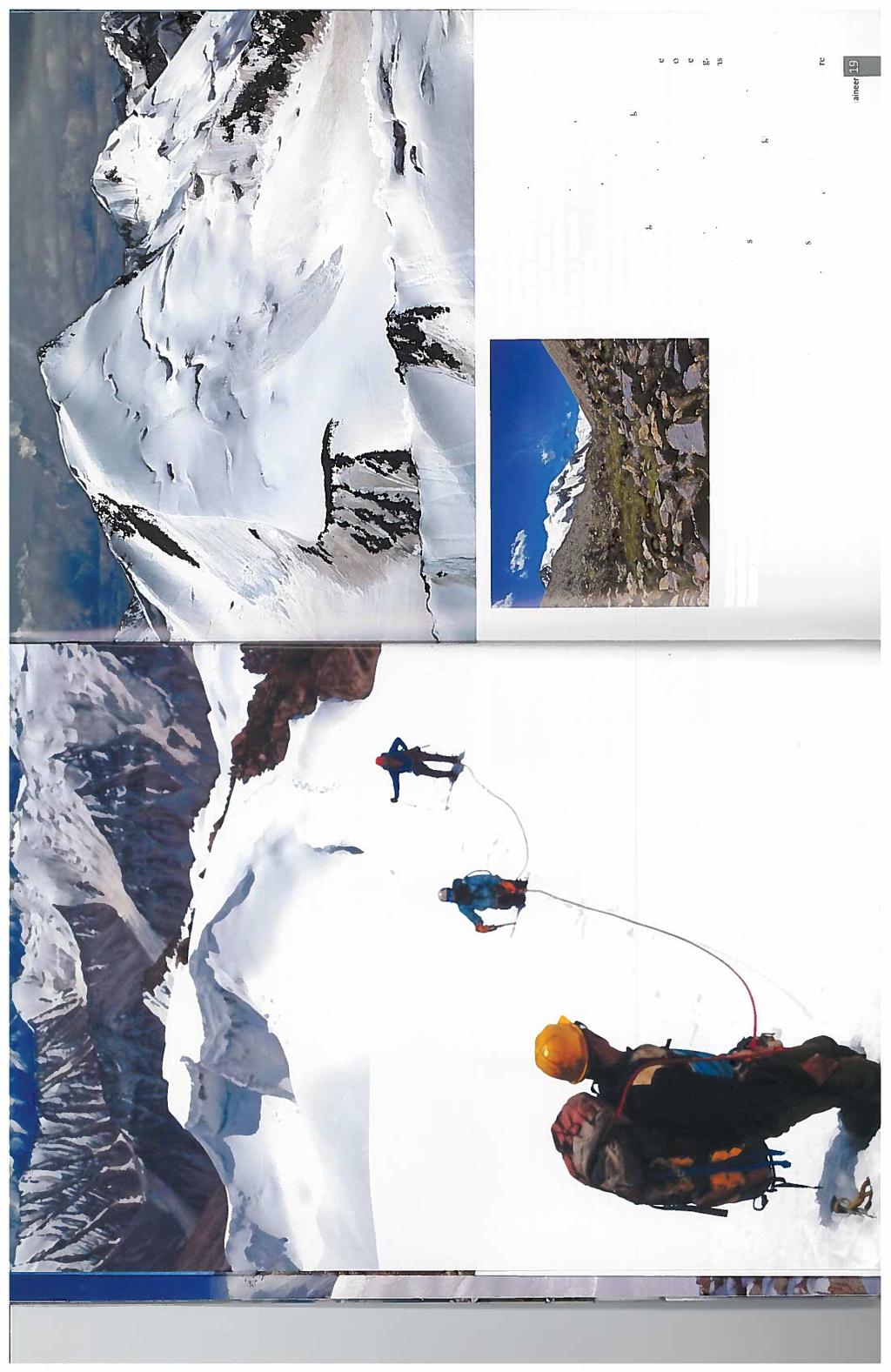
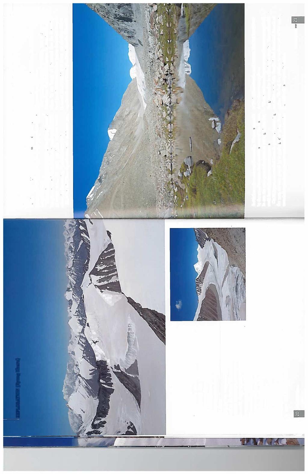
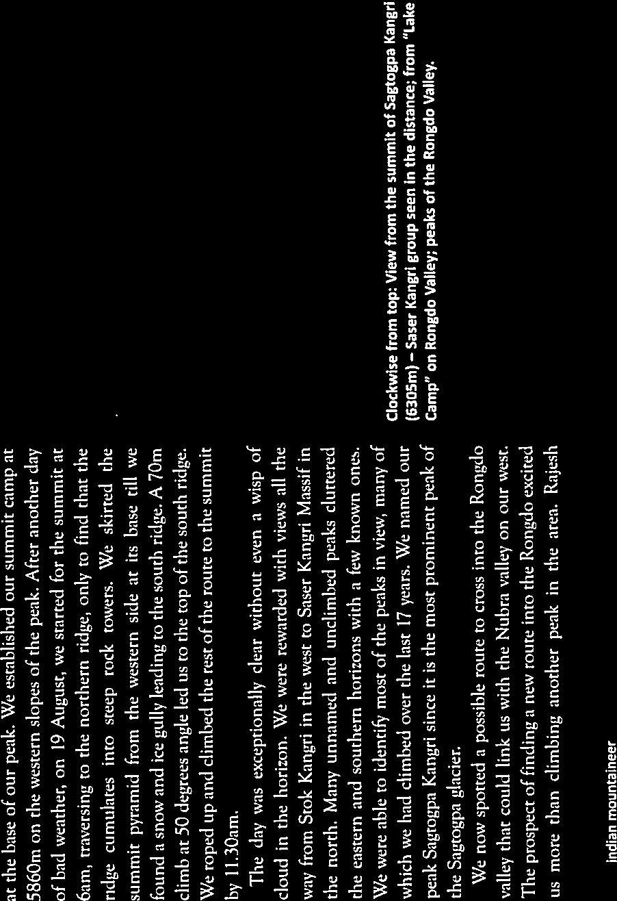
16 Further exploration Appendix 2 contains all the research of the area that was conducted by the team, including previous expedition reports. There is still potential for further exploration in the region, however, a number of the easier peaks have been climbed. Venturing deep onto the upper SE Shukpa Kunchang remains a feasible option with numerous unclimbed peaks. A Canadian team explored this area in 2014 but didn t climb any of the peaks. Another option would be to venture onto the Muztagh Glacier from the Kunzang Togpa. Access in summer is limited due to high river levels in the Shyog valley. Of further interest is the Ryong Kharu valley, this looks interesting and would lead up to the Nagpo Col and Peak X3. Access is via the Shyog valley and is therefore dependent on river levels. A team led by Divyesh Muni in 2015 accessed the Ryong Kharu valley and climbed two virgin peaks and crossed the Sagtogpa Col onto the Sagtogpa Glacier into the Rongdo valley. A copy of the report is included at the end of Appendix 2. In terms of technical climbing there are many options, especially in the lower parts of the Rongdo valley. The picture below features a peak situated westwards from Gazgazri (see map within the IAF expedition report). The approach would be straightforward but stable, cold conditions would be required given its orientation to the sun. Unclimbed peak westwards of Gazgazri On any future expeditions I would recommend going in August to allow for as much snow melt to occur which would allow easier access to and faster travel on the glaciers. 16
17 Thank you The expedition team would like to thank: Katie Poulter and David Hillebrandt, for their medical advice. David Chalmers for being our home contact while we were away and updating our families on our Spot tracker locations. The BMC and MEF for their financial support. Mountain Equipment, DMM and Terra Nova for their support. Further contact For further information please contact Ed Poulter 17
18 Appendix 1 IMF letter 18
19 Appendix 2 Previous Expeditions to the Rongdo Valley Extract of the 2012 Canadian Expedition from the Himalayan Club Newsletter 27, June 2013 Rongdo (Rongdu) Valley, first ascents. East Karakoram The Rongdo valley was first explored by the Indo-American mountaineering expedition in 2005, led by Divyesh Muni and Don Goodman. This team descended the valley in two days from the Satti area to the north. This Indian-Canadian team entered the Rongdo valley on 5 August, from the village, following the south side of the river. Base camp was at 4802m, and advanced base at 5181m just below, Ngapo Kangri ( blue sheep in Ladakhi) or Rongdo I (6350 m). On the 18th, after several reconnaissance trips, eight members of the team climbed the west subsummit (6000 m) of Balden Lhamo (named after a female goddess) or Rongdo III. They reached the col between Rongdo III and IV, then continued up the southwest ridge, returning to camp in a 10- hour round-trip. On the 22nd, six climbers ascended Chamba (the future Buddha, 6170 m) or Rongdo II via the southeast glacier (10 hours round-trip). On the 23rd, Nangang and Joei climbed the upper west rock ridge of Ngapo Kangri to about 60 m below the corniced summit (12hours round-trip). At the same time Andy and Arvind were ascending the same peak via its south-facing slopes, first on talus and rock ledges, then up the avalanche-prone southeast aspect to easier-angled slopes, from which they finally gained the summit (14 hours round-trip). On the 27th, Arvind, Dawa, Kunzang, and Joei headed up the main glacier to attempt the true summit of Balden Lhamo (6120 m). From a high camp at 5690 m, they reached the col at 6060 m above the icy headwall but retreated in the face of poor weather. On the 29th, Andy and Nangang left a high camp at 5181m, several kilometres northeast of advanced base, to climb Gazgazri (Ladakhi for the lammergeyer vulture, 6160 m). They ascended the southwest ridge, then traversed onto the icy south face. Several short pitches, the last being 70 hard ice, led to the summit dome, and thence the highest point. They returned to base camp after a 14- hour day. Members: Dr. Jeff Dolinsky, his wife, Joan, and Joie Seagram, all from Canada, along with Andy Selters (USA). Indian climbers Kunzang Sherpa (Sirdar). (Joie Seagram, Canada) 19
20 Extract of the 2012 Canadian Expedition from the Himalayan Club Newsletter 26, February 2013 CLIMBING IN THE RONGDO VALLEY We were a modest group of four climbers: Three Canadians (Dr. Jeff Dolinsky, his wife Joan and I) and one American (Andy Selters). In addition, we were accompanied by Kunzang Sherpa (Sirdar), Arvind Raman (LO), Danuru Sherpa (Dawa) and Nangang Bhote, and three camp cooks/support staff: Raj Kumar Rai, Mu Gombu Rai and Chamu Singh. Our climbing objectives were located at the head of a beautiful and remote valley called Rongdo in the Nubra area of Ladakh, lying between the east and west arms of the Shyok river. Tom Longstaff travelled close to what is Rongdo village today (3000 m) while exploring the Siachen glacier and Saltoro areas in It gave me quite a thrill to look west across the lovely, wide meandering Shyok and imagine Longstaff moving slowly up the opposite bank on his way north to be so close to his footsteps! Rongdo valley has seen virtually no visitors, save one Indian-American climbing team in 2005 which descended the valley (in two days) from the Satti area due north of Rongdo valley (HJ Vol 62; AAJ Vol 48). I initially called the four peaks (all just over 6000 m) forming the natural cirque in which we climbed Rongdo I to IV, but we have since applied local names consistent with Tibetan culture which forms the foundation of Ladakhi society. These names are officially registered with the Indian Mountaineering Foundation. From Rongdo village (3000 m) on August 5 we began our walk up Rongdo valley heading northeast, and following the south side of the Rongdo river. Upon reaching the head of the valley we pushed a little higher to establish Base Camp (4802 m) on August 10. Over the next few days we explored higher, trending north-easterly in search of a suitable Advance Base Camp (5181 m), which we established on August 14, just below our main climbing objective Ngapo Kangri or Rongdo I (6350 m). From this glorious grass-covered camp, suitable for casual football and Frisbee, we could see the unnamed glacier and cirque with the Rongdo peaks (Rongdo I to IV moving clockwise). After several reconnaissance trips to Ngapo Kangri, and up the main glacier to view the cirque of Rongdo peaks, on August 18 Andy, Jeff and Joan, Kunzang, Dawa, Nangang, Arvind and Gombu climbed the west sub-summit (6000 m) of Balden Lhamo (Rongdo III) via the col between Rongdo III and Rongdo IV, then up the southwest ridge (10 hrs return). 20
.")
21 On August 22 Jeff and Joan, Kunzang, Dawa, Nangang, and Arvind climbed Chamba (6170 m) or Rongdo II via the southeast glacier (10 hrs return). On August 23 Joie and Nangang climbed the upper west rock ridge of Ngapo Kangri to 60 odd metres below the corniced summit (12 hrs return). At the same time Andy and Arvind ascended Ngapo Kangri via the southerly slopes; first on talus and rock ledges, then (with care) up the avalanche prone southeast aspect to easier angled summit slopes, finally gaining the corniced summit (14 hrs return). ]On August 27 Joie, Kunzang, Dawa and Arvind headed up the main glacier to attempt the true summit of Balden Lhamo (6120 m); a high camp on the glacier was established at 5690 m. An early departure the next morning got us up the icy headwall to the col (6060 m) by 9.00 am, where the steep west ridge curves south to become the long exposed summit ridge. The weather was distasteful to say the least and with minimal technical ice gear and limited technical ice experience in the party, it would have been folly to attempt this long ridge, hence disappointed we retreated. On August 29 Andy and Nangang left a high camp at 5181 m, several kilometres northeast of our ABC, to climb Gazgazri or peak 6160 m. They ascended the southwest ridge, then traversed onto the icy south face, after which several short pitches the last being 70 degree hard ice, led them to a ledge at the edge of the summit dome, whence they ascended to the highest point (14hrs return to BC). 20

22 By August 31 we were all ensconced at BC looking forward to the upcoming evening s Full Moon celebration. Indeed we had a most enjoyable time singing together around a wonderful dung fire we were a well-harmonised international climbing group! Next day we descended the valley taking two days to arrive back at Rongdo village. Sept 3 we returned to Leh via the Kardung La. Notes i. Ngapo (Rongdo I) is Ladakhi for (male) Blue Sheep. ii. Chamba (Rongdo II) means future Buddha. iii. Balden Lhamo (Rongdo III) is the name of a female goddess (Rongdo Gompa). iv. Gazgazri (Peak 6160) is the local Ladakhi spelling for Lammergier (Bearded Vulture). Joie Seagram (Article HJ 69) Joie Seagram (Article HJ 69) 21
23 from Andy Selters expedition member Canadian Expedition 2012 Received 29/06/14 Hello Matthew: Sorry but Joie was our trip leader and she prepared all of our reports, and I don't think she has anything else written up either. She's in Nepal at the moment and will be going back out of Rongdo (which I found, was the correct word) to climb in August. She won't be going toward the SE Shukpa Kunzang Gl., which I assume is where you're headed. She also did not go up that direction in 2012, but I got more of a look over there when I climbed the peak I've named Gazgazri. On the Swiss map it is labeled 6160 between the Kayok and SE SK Glacier. Unfortunately it was kind of stormy on that climbing day and I didn't get a great view to the N and NW. But I have a pretty good idea that with some easy recon you should not have a problem finding a way to cross over to the SE SK. I am also going back with a different small group to Rongdo village and trekking up the canyon a ways in August coming, for a scenic acclimatization trek before climbing elsewhere in the region. If you have specific questions I might be able to answer them. Take care, Andy S 22
24 from Jeff Dolinsky expedition member Canadian Expedition 2012 Received 01/09/14 Hi Matt, We didn't prepare a trip report. It was very straightforward as we hired Rimo Expeditions in Leh (and Delhi) as our outfitter and the company was perfect for our needs. In fact I cannot imagine organizing this without them. Permitting is very hard. Joie had a hell of a time getting her X visa for her trip back there this year. Lots of military checkpoints to show papers to along the way. Very sensitive area. I would recommend taking an inreach sat communicator and only using it if necessary. As a point to consider, we used a horse team to transport our gear to and from base camp. There are no porters, yaks or horses available in the Shyok valley. No guides either. Our guides were from Darjeeling and Nepal. The horses and wranglers came over Khardum La to meet us. Pretty tough logistics, IMO. The best maps we got were the Russian made ones. The glaciers are very mellow and there is lots of great granite. Good luck I have not too much else to add. We found the place very magical the local families were especially nice. I hope the place never gets spoiled. Jeff Dolinsky 23
25 Rongdu Valley Exploration May Jun 2013 Gp Capt V K Sashindran A team of 12 mountaineers from the Indian Air Force explored the little known Rongdu valley in May Jun This valley has seen only two forays in the past. The team spent 35 days in the valley, explored the main valley and its major side valleys and, climbed 8 virgin peaks in that area. Rongdu togpo is a small stream originating in the glacial mass of East Karakorams north of the Shyok river in the Nubra region. The Rongdo village (N 34 o E 077 o ) is located at the mouth of the stream and is 35 km from the bridge across the Shyok at Timur and 52 km from Hunder. Tsati, a large village with a primary health care centre, is its nearest neighbour and is located 20 km away to its west and is connected to it by a dirt track. For the sake of easy description, the Rongdu valley can be divided into 2 parts: the lower and upper Rongdu valleys. The lower Rongdu valley extends from the site where the river debouches into Shyok river up to a little below the location of the Hot Springs. The former also corresponds to the location of the Rongdu village and the latter to the place where Tara togpo from the left and Koyak togpo from the right join a stream Sakskyulas coming from up north to form Rongdu togpo. This marks the general upper limit of the summer grazing area of the Rongdu villagers. Upper Rongdu comprises of the Sagtogpa glacier from which 2 streams originate and join to form Sakskyulas. There are 8 side valleys on the true left side and 4 on the right. For sake of description, the valleys are referred to by the side on which they are located and numerically starting from the head of the valley. In Upper Rongdo, there are three side valleys L1, L2 and R1. All others are in Lower Rongdu. There are only 3 broad side valleys and they are L1, L2 and R1. Of these, the longest is L2. All the others are just steep gullies cut by glacial streams originating from the mountain ridges that hedge the valley on its east and west. Immediately beyond Rongdu village, the valley narrows to a defile. The narrowing is due to a large rockfall on the true right side. The trail is about 3 feet wide in Lower Rongdu and this mainly due to regular movement of people, cattle and flocks of sheep moving up and down the valley. 500m beyond the village, the trail starts climbing and snakes up the right side of the valley. It ascends steeply for about 400m and then descends more gently to a small clearing with many trees and brooks running through it called Changma (N34 o E 077 o , elevation ). From Changma the trail goes up and down screes on the left side of the valley till you reach Thipti (N 34 o E 077 o ) 20 min away. The trail stays to the right of a clump of willow trees with some pasture land all enclosed by a fence of thorny branches. A small adobe hut perched on a huge rock within the enclosure cannot be missed. Doksa (N34 o E 077 o altitude ) is an hour s walk from Thipti. At Doksa the valley widens considerable. Rongdo togpa runs along the right side of the valley and to its left is a large meadow which has now been brought under plough and serves as arable land for Rongdu villagers. Numerous rivulets coming down from glacial melts high up on the left side of the valley serve as convenient irrigation channels which the villagers keep damming or diverting to irrigate their fields. There are 5 stone and mud dwellings where the villagers reside when they come up to Doksa in mid-may. The fields are then tilled, and wheat sown. 24
26 The villagers return to Rongdu and then come up once a month to water the fields. Later, in the season they take their sheep and yaks higher up the valley for summer grazing. The sheep and yak dung is store in stone corrals and used the following year to enrich the fields. Beyond Doksa, boulders brought down by mountain torrents and landslides makes cultivation impossible but small pastures abound. The valley remains wide all the way up to the confluence of the Rongdu togpo with the stream coming down from the second valley on the left (L2). This valley is called Chudon nangma which can be translated as hot water valley. This refers to the hot springs located to the east of the confluence of the two streams. Nangma is the Ladakhi word for a big valley. This valley is referred to as Chhurn nangma in the Survey of India maps. The expansive meadows here make good grazing and camping grounds. On the way up the main valley we did not go to these meadows. Instead, we followed the Saskyulas further up to where a tributary from the first valley on the right (R1) joins it. We crossed this stream and set up our first base camp- BC1 (N 34 o E 077 o , altitude ) on a meadow to the left of this tributary. This site is a 45- minute walk from the Hot Springs. A broad peak is visible to the true right of the main valley just as you approach the base camp. The peak looks like a truncated pyramid and this peak was our first objective. A reconnaissance trek up the main valley showed that this peak is part of a massif that extends along the right side of the Upper Rongdo valley all the way up to the head of the valley. The steep face, ice overhangs and cornices that were visible on the western aspect of the mountain made it clear that it could not be climbed from the main valley side (i.e., east face). Moreover the scree and large boulders at its base made going up the valley difficult. Two streams come down from the Sagtogpa glacier at the head of the main valley. The right stream begins at the foot of the Ngapo Kangri (Rongdu I) peak and flows below the terminal moraine blocking the entrance to the first side valley on the left (L1). This valley was explored by a Canadian expedition in This is a broad valley and has many peaks above 6000m hedging it. There is a cirque at the head of the valley now named Canadian cirque. In mid-may, Upper Rongdu was still draped in snow. The snow over the boulders made the going difficult and we had to walk along the streams to reach the head of the valley. After the initial reconnaissance, we turned our attention to R1. We climbed up the ridge on the true left of the R1 and followed the ridgeline. There are many cairns on this ridge erected by shepherds and the valley is thus called Theorchung lungpa (Tiburchang valley in Survey of India maps). Theor is the Ladakhi word for cairn and lungpa is the word for a narrow valley. It takes 3 hours to reach the head of the valley and we established our first advance base camp (ABC 1) over here (N34 o E077 o , alt ). Half a kilometre ahead to the northwest was a cirque which separates this valley from a glacier referred to in the Survey of India map as the Lung Tung glacier. There are two cols on this cirque, one to the south west and the other to its north. The latter is a broad one and was named the Vayu Sena col. The cirque was also named the Vayu Sena cirque, (Vayu sena being the Hindi term for Air Force). Just beyond the ABC and to its northeast was a big glacier. This glacier, we discovered, goes along the north-western aspect of the mountain that we wanted to climb. It is possible to go along the glacier and reach the head of the Rongdu valley. A route up the mountain was discovered from its western aspect along a southwest ridge which started just beyond our ABC. An attempt of the peak was made on 18 May The route up took 6 hours. After the first hour of climbing, we found the snow firm enough to use crampons. The route followed a north-easterly course. After another 3 hours of climbing, the slope became rocky and we had to take off the crampons. The last 50m was like a tongue, a flat but steep slope. The peak had a 2m overhang on the eastern side and 25
27 we had to be careful not to step too close to the edge. On the way down, the right border of the tongue gave way and crashed down into the valley below. The ice on the track cracked and sank and we had to hurry across. This peak was named Sa i Lhamo which is the Tibetan term for the Earth goddess (N34 o E077 o alt ). A team of 3 experienced mountaineers crossed the head of Tiburchung glacier and set up a summit camp to the north of a peak whose spot height on the map was 6160m (N34 o E077 o , alt ). This peak is located to the northeast of the head of Tiburchung glacier. A cirque located to the southeast of this peak and across the head of the glacier separates Tiburchung glacier from Koyak and Lung Tung glaciers. The cirque continues northwards across the head of the glacier, encircles the peak and then extends in a south-easterly direction separating the head of the Rongdo valley from SE Shukpa Kunchang glacier. The summit camp was a 4-hour walk from the ABC. Peak 6160 was attempted on 21 May A blizzard and poor visibility almost made the team sit out of the attempt. However they set out at 0530h after the blizzard showed signs of abating. They took the northwest ridge up. The gradient was 45 o but the snow firm and good for climbing. After 3 hours they reached a height of (5990m). They had to then turn back as the weather deteriorated and fixing a rope for further climbing seemed unfeasible. This peak was named Lungkhor Kangri in view of the glacier encircling it (N34 o E 077 o ). Both summit teams returned to base camp and the entire group moved up the main valley. From the base camp the trail climbs steeply northwards for 20 minutes. The terrain then levels off, climbing gently and crossing a well- watered meadow. On our way up this was still covered with 1 foot of snow. After a 2 h walk, keeping to the right side of the Sakskyulas, we had to ascend steeply again for 15 minutes. This brought us to a small meadow directly opposite the mouth of the valley explored by the Canadians. We established our new base camp- BC2 here (N 34 o E 077 o alt ). The aim was to explore and climb in the upper reaches of the main valley. A recce team crossed Sakskyulas just below the base camp, skirted the terminal moraine of the Canadian valley and then followed the rivulet coming down from the left side of the main valley. Keeping to the right of this rivulet, they ascended a medial moraine and got a glimpse of the SE Shukpa Kunchang glacier at the head of the valley. There was another glacier coming from the east between Ngapo Kangri and a pyramidal peak to the left of the SE Shukpa Kunchang glacier. This probably is the Sagtogpa glacier arising from the Kunzang group of peaks located to the north east. A branch of the Sagtogpa glacier then swings south into the Rongdo valley.to the right of the SE Shukpka Kunchang glacier was a massif running in an east west direction. This was separated from the Sa i Lhamo massif by the Lungkhor glacier coming from R1. The peak on the massif to the right of the SE Shukpa Kunchang glacier was the next target. To reach its base a summit team followed a rivulet coming from the right edge of the valley. After 1 ½ h they ascended steeply up the glacier at the head of the valley, keeping to the right edge of the valley all along. Then they crossed the Lungkhor glacier coming eastwards from R1 and established a summit camp below the peak marked as 6100 on the map (N E , alt [5670m]). The trek up to the summit camp took 5h. Hot sun and the fierce glare from the glaciers made it a tedious climb. The team left for the summit at 0330h on 25 May 13. The sky was overcast but there was no wind. The snow was crisp and firm. The team walked west parallel to the massif. After 45 min, they climbed up a ridge jutting southwards at right angles from the main massif. This brought them to the northern face of the mountain. From here it was a steep climb to the ridgeline of the main massif. The snow was firm and crampons made climbing easy. Once the ridgeline was reached, the snow thinned out and flaky 26
28 rocks appeared. The gradient was less steep now but the climb continued in an easterly direction. The promise of a rose pink dawn was thwarted by clouds crowding in and a stinging blizzard. The team reached the summit at 0702h (N 34 o E 077 o alt ). This peak was named Khyung Kangri as it resembled the mythological Garuda guarding the head of the Rongdu valley with its wings spread out. Khyung is the Tibetan word for Garuda. The massif is actually L shaped and extends west east along the glacier coming from R1 and then south north along the right side of the SE Shukpa Kunchang glacier. The deteriorating weather made the team scurry back to summit camp and then further down to ABC the same day. The second summit team left ABC for the summit camp the same day. They planned to attempt a peak to the north- west of Khyung Kangri. They left summit camp at 0315h but had to stop soon because of strong winds and heavy snow fall. After an hour they were able to resume their climb. They followed the same trail that the first team had taken the previous day. After crossing the ridge extending southwards from the Khyung Kangri massif they descended to a heavily crevassed area and had to rope up. They went in a northerly direction up a gully which went up the summit ridge located to the east. The snow was firm and they climbed using the three-point technique. After 200m ascent, the route became rocky. They climbed a hump and could see the summit another 200m above. A rope was fixed for 50m as the gradient was 60 o and the peak was summited at 0617h. This peak was named as Chu Skeyes kangri (Chu Skeyes = lotus [Tib], N34 o E077 o alt ). The team returned to summit camp at 0800h and after a quick breakfast, decided to take advantage of the lull in the weather and attempt another peak nearby. The peak they selected was located to the southwest of the summit camp and was on a northeasterly flank of Sa i Lhamo. The team took half an hour to reach the base of the peak and climbed it from an easterly spur. The team of 6 members reached the summit after 2h of climbing. This peak with its elongated easterly spur resembled the head of an elephant and was therefore named Langpoche (Langpoche= elephant head [Tib], N 34 o E077 o , alt ). The team then returned to the advanced base camp the same afternoon after a gruelling but extremely satisfying climb. The next plan was to go up the main valley cross the Sagtogpa glacier, explore southeast Shukpa Kunchang glacier and climb the pyramidal peak between this and the Sagtogpa glaciers. However, the weather played foul. It snowed incessantly for 3 days. On the fourth day when there was a break in the weather we decided to descend to Hot Springs. The fresh snowfall had made climbing risky. We saw avalanches slithering down the peaks in the Canadian valley. Our attention now turned towards the Chudon nangma (Chhurn nangma in Survey of India maps) and the side valley further south (L3). After savouring the salubrious environs of the Hot Springs camp, a reconnaissance of the valley was done. It is a 3-hour walk on the left side of the valley till the valley closes in with a spur on the left side and rocky scree on the right. Two streams originate from the two sides and soon join up to form the river which we had followed up. The river was frozen at that time, covered by a thick icy layer about 3 feet thick. We could hear the water roaring under it and the ice cracking in places, all intimations of summer which was well underway. A group of 4 tried climbing up the spur on the left. There were two peaks above the spur which looked challenging. On going up the spur, they discovered a cwm there but the ice wall to the southeast and hanging glaciers made it too risky to climb from this side. Later we would discover that the best route up these peaks would be from the east across the glacier feeding the Chhurn togpo. Another team climbed up the rocky scree on the right side of the valley. From the top of the scree, a rock face was visible and a trail could be seen 27
29 skirting the slope of the ridge to the right of the valley. A further scouting trip up this side revealed that after a 2 ½ h walk, the valley suddenly widened and a huge glacial lake dammed by the rock face existed. This glacial lake is formed by the glacial melt of the Shan Lung glacier which lies like a crescent above the valley and to its south. Shan= snow leopard [Ladakhi], referring to the fact that we saw pug marks of the snow leopard all the way across the glacier. Straight ahead to the east was a big massif. A branch of the Shan Lung glacier swept northwards along the base of the massif and continued northwards east of the Canadian cirque. North of this massif was another glacier running in an east west direction and joining the Shan Lung glacier at the base of the massif. In the middle of this glacier was a solitary peak (Island peak) which looked interesting. But our first challenge was the big massif dominating the Shan Lung glacier. To climb this massif we established a new ABC3 (N34 o E 077 o alt ) just ahead of the rock face and on the banks of the glacial lake. From here, the route went eastwards to a small col (N34 o E078 o , alt ) overlooking the Island peak. This was named Chugnis col, referring to the twelve-member Air Force team). From here, the route veered south eastwards following the medial moraine of the Chugnis glacier to the base of the massif. Then the team skirted the base of the massif in an anticlockwise direction and reached a gully between the two arms of the massif. The massif has three peaks: the highest one on the north-eastern corner, the next one on the western limb, and a third plateau peak on a ridge extending southwards from the main peak. A narrow glacier descends in the gully between these peaks and goes on to feed the Shukpa togpo stream. A summit camp was established on a hillock in the gully (N 34 o E 078 o , alt ). A team of 4 members and 4 sherpas and Ladakhi nonoos left the summit camp at 0400h. The trail followed a ridge extending from the hillock in a north-easterly direction. The gradient was 45 o and it took 1h to reach the head of the gully. We were now at the base of the col on the north between the two main peaks of the massif. We started climbing up the slope which had a gradient of 60 o and 50 m below the col veered to the right i.e., in a south easterly direction. It took us two hours to reach the ridgeline from the base. From here it was a 30 min climb to the main summit. The view from this peak was stupendous. There was a big glacial valley with a number of high peaks on the east (Muztagh glacier). To the west, the Shan Lung glacier and the Chhurn nangma were seen in their entirety. Across the Rongdu valley Karpo Kangri could be seen towering in the southwest. To the north the southern rim of the Canadian valley was visible and the Kunzang group of peaks to the northeast. This peak was named Odgsall I (Odgsal = Clear light [Tib], N 34 o.8 E078 o , alt ). The team descended to the summit camp and thence to the ABC in order to make place for the next summit team. This team followed the same route to the base of the Odgsal col and then rapidly climbed up the eastern face of the peak in the western limb of the massif on the next day. They were able to climb up in 1 ½ h. This peak was named Odgsal II (N34 o E 078 o , alt ). The third team was scheduled to climb the plateau peak (Odgsal III) but the plan was abandoned. Four days of bright sunshine had made the snow unstable and the route up along the western slope was fraught with avalanche risk. Instead another peak was selected close to the ABC. This peak located in the southern ridge of the Canadian valley was up the first gully ahead of the ABC. The team headed east from ABC up to the col and then veered left to ascend the gully in 45 min time. They then ascended steeply up a glacier to reach a cirque in 2h 15 min. This glacier was named Dabin glacier as it resembled a bowl (Dabin = bowl [Ladakhi]). From there they could see 2 peaks one to the west and another to the east. The team decided to attempt the latter. The slope gradient was 70 o and a rope had to be fixed for the last 25m. The peak was climbed by the east- west ridge. And this was achieved in 4h 45min after leaving ABC. The Ladakhi climbers felt that the peak resembled a vulture 28
30 head in profile and it was thus named Charok (Charok = vulture in Ladakhi, N34 o , E 077 o , alt ). While the third summit team was climbing Charok, the first team decided to go up the Rongdo valley up to the glaciers, a task they had left undone due to the bad weather. The team left base camp at Hot Springs at 0600h. They first tried to ascend along the left side of the Sakskyulas but had to abandon the idea as the boulders made going difficult. They forded the stream and climbed on to the flat meadow which they had crossed while going to ABC 2. They then descended to the stream, forded it, skirted the terminal moraine of the glacier coming from L1 and the base of Ngapo Kangri and then turned left. Ascending sharply, they reached a snowfield which was the highest point in the valley at 1100h. From here, 3 glaciers were visible. The SE Shukpa Kunchang to the north, the Lungkhor glacier to the west and Sagtogpa glacier coming from the north of Ngapo Kangri in a westerly direction and then turning south into the Rongdu valley. This point, was named Air Warriors Col (N34 o , E 077 o , alt ). The third valley on the left was also explored. L3, Thara lungpa is a short valley dominated by a hanging glacier, Thara kangri glacier. The glacier snout is 30m high and one has to negotiate a snowfield similar to the one at Everest Base camp to reach it. The climbers climbed along the right edge of the glacier snout and reached the glacier after 3 h of climbing. There were 2 peaks above but the sheer rock faces made ascent from Rongdu side impossible. From Odgsal I we had already seen that these peaks could be climbed easily from the eastern side after crossing Shan Lung glacier. The Air Force expedition spent 5 weeks in Rongdu valley. They climbed 8 peaks, successfully summiting 7, six of which were more than 6000m high (Details in table 1 below). The greatest achievement was that all this was accomplished without anybody falling ill or any mishap. Peak Table 1. Summary of climbs Name suggested 1 Sa i Lhamo m 2 Lung Khor m 3 Khyung Kangri m 4 Chu Skeyes Kangri Height Date of Ascent m Team 18 May 13 Members:Gp Capt VK Sashindran, Sqn Ldr S Dubey, Sgt G S Pokhariya, Cpl JPS Raina, Cpl S Bohra, Cpl JR Poonia Sherpas/Ladakhi nonoos: Skalzang Rigzin, Tshering Bhutia, Karma Sherpa, Tashi Zangla 19 May 13* Members: Sgt C Y Basavraj, Sgt D K Vyas, Cpl D Chhetry Sherpas/ Ladakhi nonoos: Konchok Thinles, Tsewang Rigzin, Dawa Norbu, Stenzing Desal 25 May 13 Members: Gp Capt V K Sashindran, Sqn Ldr S Dubey, Cpl JPS Raina, Cpl S Bohra, Cpl JR Poonia Sherpas/ Ladakhi nonoos: S Rigzin, K Thinles, Tashi Gyalson, S Desal, Tsewang Gialston 26 May 13 Members: Sqn Ldr Avinash Prasad, Sgt CY Basavaraj, Sgt D K Vyas, Cpl D Chhetry, Cpl IA Dar Sherpas/ Ladakhi nonoos: S Rigzin, T Zangla, T 29
31 5 Langpoche m 6 Odgsal I m 7 Odgsal II m 8 Charok m Rigzin, K Sherpa, D Norbu, Cheder Bhutia, Dawa Gyalpo 26 May 13 Members: Sqn Ldr Avinash Prasad, Flt Lt K S Sanghera, Sgt CY Basavaraj, Sgt D K Vyas, Cpl D Chhetry, Cpl IA Dar Sherpas/ Ladakhi nonoos: T Zangla, T Rigzin, K Sherpa, D Norbu, C Bhutia, D Gyalpo Members: Gp Capt VK Sashindran, Sgt GS Pokhariya, Cpl JPS Raina, Cpl JR Poonia Sherpas/Ladakhi nonoos: K Thinless, D Norbu, D Gyalpo, Tashi Phunchok Members: Sqn Ldr S Dubey, Flt Lt KS Sanghera, Sgt CY Basavaraj, Cpl S Bohra Sherpas/Ladakhi nonoos: S Rigzin, K Thinles, D Gyalpo, S Desal Members: Sqn ldr A Prasad, Sgt DK Vyas, Cpl D Chhetry, Cpl IA Dar Sherpas/ Ladakhi nonoos: S Rigzin, K Thinless, S Desal, T Bhutia *Not summited, height mentioned refers to the actual height climbed. The peak s height as per Survey of India map is 6160m. 30

32 31
33


34


35


36


37
The height of Machu is 6630m on the Swiss map, 6612m on the Russian map and 6603m on Google Earth.
 Hispar Expedition 2017 Expedition Final Report MEF reference: 17-42 Country and region visited: Pakistan, Hunza Valley, Karakoram. Objective To make the first ascent of Machu (6630m) by the southwest and
From Rassa to Sumur..a journey of exploration and climbing.
 From Rassa to Sumur..a journey of exploration and climbing. In 2001, a glimpse of Rassa glacier, during our expedition to Arganglas valley indicated great opportunity for exploration and climbing. In July
Stok Kangri Peak (6120m) 2 to 16 September 2018 Explore the hidden kingdom of Ladakh with Stok Kangri Peak
 2 to 16 September 2018 Explore the hidden kingdom of Ladakh with Stok Kangri Peak") Stok Kangri Peak (6120m) 2 to 16 September 2018 Explore the hidden kingdom of Ladakh with Stok Kangri Peak Stok Kangri is a perfect objective for fit trekkers without climbing experience, and is one of
Stok Kangri Peak (6120m) 2 to 16 September 2018 Explore the hidden kingdom of Ladakh with Stok Kangri Peak Stok Kangri is a perfect objective for fit trekkers without climbing experience, and is one of
Chasing Skylines in Kyrgyzstan BMC Reference: 15/ 02
 Chasing Skylines in Kyrgyzstan 2015 BMC Reference: 15/ 02 21/02/2015 to 15/03/2015 Contact: Sophie Nunn Email: Sophienunn@gmail.com, Phone: 07540454054 Address: 7 Richmond Lodge, 6 Victoria Avenue, Swanage,
STOK KANGRI 5490M STOK KANGRI TREK Aug 03-15, 2019
 STOK KANGRI 5490M STOK KANGRI TREK Aug 03-15, 2019 STOK KANGRI TREK: INTRODUCTION One of the most popular trekking peaks in the Indian Himalayas and on the planet, the proximity to Leh (the capital of
KANG YATSE-II KANG YATSE-II TREK Jul 23 - Aug 04 &Aug 15-27, 2019
 KANG YATSE-II KANG YATSE-II TREK Jul 23 - Aug 04 &Aug 15-27, 2019 KANG YATSE-II: INTRODUCTION The Western Summit of the Kang Yatse Peak, or Kang Yatse II, offers the perfect challenge for folks looking
Two Peaks in the Headwaters of Karcha Nala JAC Tokai to the Indian Himalayas
 KAZUO HOSHI Two Peaks in the Headwaters of Karcha Nala JAC Tokai to the Indian Himalayas The Tokai Section of the Japanese Alpine Club (hereinafter described as JAC Tokai) conducted 11 expeditions to the
PERUVIAN ANDES ADVENTURES. TOCLLARAJU CLIMB or ISHINCA + TOCLLARAJU CLIMBING. Tocllaraju 4 Days Ishinca + Tocllaraju 5 or 6 days
 PERUVIAN ANDES ADVENTURES TOCLLARAJU CLIMB or ISHINCA + TOCLLARAJU CLIMBING Tocllaraju 4 Days Ishinca + Tocllaraju 5 or 6 days PEAKS Tocllaraju: 6034m (19797 ft) Grade: D / Hard / Some steep & technical
PERUVIAN ANDES ADVENTURES. EXPEDITION Climbing Alpamayo & Huascaran. PEAKS: Maparaju 5350m Alpamayo 5947m Huascaran Sur 6768m
 PERUVIAN ANDES ADVENTURES EXPEDITION Climbing Alpamayo & Huascaran PEAKS: Maparaju 5350m Alpamayo 5947m Huascaran Sur 6768m 23 days Huaraz to Huaraz Grade: Technical, physically demanding This is a comprehensive
PERUVIAN ANDES ADVENTURES. ARTESONRAJU CLIMB 6025m (19767 ft) Grade: D+ to TD/ Technical. Routes: The two routes to climb Artesonraju are;
 Grade: D+ to TD/ Technical. Routes: The two routes to climb Artesonraju are;") PERUVIAN ANDES ADVENTURES ARTESONRAJU CLIMB 6025m (19767 ft) Grade: D+ to TD/ Technical Routes: The two routes to climb Artesonraju are; *Via the Paron Valley South East Ridge 5 days (option for 6 with
PERUVIAN ANDES ADVENTURES ARTESONRAJU CLIMB 6025m (19767 ft) Grade: D+ to TD/ Technical Routes: The two routes to climb Artesonraju are; *Via the Paron Valley South East Ridge 5 days (option for 6 with
Muchu Chhish Expedition 2014
 Muchu Chhish Expedition 2014 MEF reference 14/21 Country and region visited: Pakistan, Batura Muztagh, Karakoram. Objectives: To make the first ascent of Muchu Chhish 7453m by the south and west ridges.
Stok Kangri Trek 2013
 Stok Kangri Trek 2013 Area: Ladakh Duration: 11 Days Altitude: 6153 mts Grade: Moderate to Challenging Towering at an impressive 6153 m, Stok Kangri is a serious challenge. Although at such an impressive
GLACIER STUDIES OF THE McCALL GLACIER, ALASKA
 GLACIER STUDIES OF THE McCALL GLACIER, ALASKA T John E. Sater* HE McCall Glacier is a long thin body of ice shaped roughly like a crescent. Its overall length is approximately 8 km. and its average width
18 day itinerary: ACONCAGUA Normal Route 15 day trek. T r i p I t i n e r a r y
 T r i p I t i n e r a r y HIGHLIGHTS Summit the highest mountain in South America, and the second highest of the Seven Summits Breath-taking views of the Andes Three days set aside for the summit attempt
TREK THE ROCKIES ABOUT THE CHALLENGE TREK THE ROCKIES FOR HIGHLAND HOSPICE CANADA TREK DEMANDING
 TREK THE ROCKIES CANADA TREK DEMANDING ABOUT THE CHALLENGE The Canadian Rockies are justifiably world-famous for their magnificent scenery: the combination of impressive, jagged mountains, bright turquoise
TREK LADAKH - THE HIMALAYAN KINGDOMS
 TREK LADAKH - THE HIMALAYAN KINGDOMS 1 ITINERARY OUTLINE FOR BESPOKE TRIPS The Markha Valley Trek is certainly one of the most varied and beautiful treks in the world. It ventures high into the Himalayas
RUSSIA. Elbrus. I
 RUSSIA Elbrus RUSSIA Elbrus Mount Elbrus is the highest peak in Russia and Europe and although many mountaineers visit the area to climb the mountain, there are also many other attractions here. On the
Island Peak (Imja Tse )
") Popularly known as Imja Tse, Island Peak is the most climbing peaks in Nepal. It appears as an island of the icy sea while viewing form Dingbuche and on close inception, it exposes itself to be the most
Popularly known as Imja Tse, Island Peak is the most climbing peaks in Nepal. It appears as an island of the icy sea while viewing form Dingbuche and on close inception, it exposes itself to be the most
Trek the highest mountain in Africa. Mt Kilimanjaro. for a trip of a life time!
 Trek the highest mountain in Africa Mt Kilimanjaro for a trip of a life time! Trip outline The expedition offers you the challenge of trekking the highest free standing mountain in the world and Africa
Markha Valley Trek 2016
 Markha Valley Trek 2016 Area: Ladakh Himalayas Duration: 11 Days Max. Altitude: 5150 mts/16895 ft) Grade: Moderate to challenging Season: Mid June - October The Markha Valley Trek is certainly one of the
NWAC Blog. Cornices - don't walk the line! Written by Robert Hahn on March 14, Last update on May 15, 2017.
 NWAC Blog Cornices - don't walk the line! Written by Robert Hahn on March 14, 2017. Last update on May 15, 2017. Human-triggered cornice fall avalanche from March 10th, 2017. The crown release exposed
GUIDE INDIA HIMALAYA STOK KANGRI ASCENT 21 DAYS SUMMER 2019
 GUIDE INDIA HIMALAYA STOK KANGRI ASCENT SUMMER 2019 21 DAYS WHERE ARE YOU GOING? INDIA HIMALAYA No words can describe the overwhelming experience of being among the world s greatest mountains you really
Ladakh Trek Trek Little Tibet amidst India s finest mountains
 Ladakh Trek Trek Little Tibet amidst India s finest mountains Travel to India and experience this stunning 5 day trek passing through the multi-coloured mountain range ornamented with villages, monasteries,
SEVEN SUMMITS TRAINING COURSE NEW ZEALAND 2017 / 2018 COURSE NOTES
 SEVEN SUMMITS TRAINING COURSE NEW ZEALAND 2017 / 2018 COURSE NOTES Seven Summits Training Course 2017/2018 Course Notes All material Copyright Adventure Consultants Ltd 2016-2017 Welcome to Adventure Consultants
MOUNT MADELINE GUIDED ASCENT 2018/2019 TRIP NOTES
 MOUNT MADELINE GUIDED ASCENT 2018/2019 TRIP NOTES Mount Madeline Trip Notes All material Copyright Adventure Consultants Ltd 2018/19 Mount Madeline (2,536m) is the second highest peak in the Darran Mountains,
Guthega to Mt Twynam. 2183m. 1583m. 6 hrs 45 mins 14.8 km Return. Experienced only. 913m
 Guthega to Mt Twynam 6 hrs 45 mins 14.8 km Return Experienced only 5 913m This walk starts from Guthega and makes its way along the Snowy River to the Illawong Lodge, via the Blue Cow Creek flying fox.
Junglam Trek. Day 02: Leh Shey Thiksey On this day you will go a sightseeing trip to some ancient monasteries in this area.
 Junglam Trek The trek starts from Hemis monastery (one of the richest monastery in Ladakh). It enters in famous Markha valley and Zanskar via Junglam, which is open only for a month. In summer this route
Dnigi Hut. Dnigi is Dnaina for Moose. Location:
 Dnigi Hut in places. Stay on the main thoroughfare. Continue along the ridge top, going east to a pass above Knob Creek. Just beyond here look for a left turn which descends north-northwest (61,45.578,-148,52.414,2081
ICELAND: VATNAJÖKULL ICECAP CROSSING
 ICELAND: VATNAJÖKULL ICECAP CROSSING This information should answer some of your questions about the trip and give you a better idea of what we do day-to-day. It doesn t hope to answer everything. If you
VINSON MASSIF EXPEDITIONS 2017/2018 TRIP NOTES
 VINSON MASSIF EXPEDITIONS 2017/2018 TRIP NOTES VINSON MASSIF 2017/2018 Expedition Notes All material Copyright Adventure Consultants Ltd 2017/2018 During the southern summer of 2017/2018, Adventure Consultants
REPORT. MANASLU EXPEDITION (8163 m) Track NE (traditional)
 Track NE (traditional)") REPORT MANASLU EXPEDITION (8163 m) Track NE (traditional) Contents Expedition passport 2 Description of the route 3 Description of the expedition 4-5 Scheme of the route 6 Map of the route 7 Map of the
REPORT MANASLU EXPEDITION (8163 m) Track NE (traditional) Contents Expedition passport 2 Description of the route 3 Description of the expedition 4-5 Scheme of the route 6 Map of the route 7 Map of the
VINSON TRIP INFORMATION PACKET TRIP INFORMATION PRICE INCLUDES:
 VINSON TRIP INFORMATION PACKET TRIP INFORMATION Location: Ellsworth Range, Antarctica Days: 21 Summit Height: 16,050 ft. Trip begins in Punta Arenas, Chile Airport (PUQ) PRICE INCLUDES: Mountain Professionals
Draft II - Trip Report by Kurt Wibbenmeyer
 Draft II - Trip Report by Kurt Wibbenmeyer COLORADO MOUNTAIN CLUB FAIRWEATHER MOUNTAIN EXPEDITION 2010 TEAM Rich McAdams Leader Mike Butyn Wayne Herrick Gerry Roach Bill Blazek Dave Covill Jim Rickard
The Cirque. Everything you need to know about climbing the Lotus Flower Tower. Southeast Face 2000 feet 19 pitches up 10 rappels down 5.
 The Cirque Cirque of the Unclimbables, Northwest Territories, Canada Created: Sept 4, 2011 Everything you need to know about climbing the Lotus Flower Tower Southeast Face 2000 feet 19 pitches up 10 rappels
MT TUTOKO GUIDED ASCENT
 MT TUTOKO GUIDED ASCENT 2018/2019 TRIP NOTES Mount Tutoko Trip Notes All material Copyright Adventure Consultants Ltd 2018/19 Mount Tutoko (2,746m) is the highest peak in the Darran Mountains, located
STEVE PRESCOTT FOUNDATION - Mt. Kilimanjaro Challenge
 STEVE PRESCOTT FOUNDATION - Mt. Kilimanjaro Challenge MACHAME ROUTE (DURATION: 8 DAYS including Crater Camp) ABOUT THE ROUTE: Many say this is the most beautiful route up Kilimanjaro; your efforts will
Annapurna Circuit Trek 17D/16N
 Annapurna Circuit Trek 17D/16N Pre Trek: Travel to Kathmandu (1,300m) : At 5:00 pm, a rickshaw will pick you up from your hotel and bring you to the trekking offices for a safety briefing on the nature
CHALLENGE OVERVIEW. ACCOMMODATION. You will be accommodated in friendly, simple hotels and tents whilst on the mountain.
 CHALLENGE OVERVIEW Mount Kilimanjaro is one of the seven Natural Wonders of the World and for many people, standing on its summit is a life-long ambition. The snow-capped peak was first reached by German
Everest Expedition 4. DBGS 4 th Everest Expedition. 23/4 March - 14 April 2017
 Everest Expedition 4 23/4 March - 14 April 2017 DBGS 4 th Everest Expedition This presentation will give you some information about the Everest Base Camp Expedition. If you would like to know more you
Mt. Rainier Three-Day Muir Climb
 Mt. Rainier Three-Day Muir Climb Details below provided by AAI Elevation: 14,411 feet Guide Service: Alpine Ascents International (AAI) Fundraising minimum: $5,000.00 USD Muir Three-Day Overview Our three-day
Mt. Gunnbjörn, Dome and Cone (IMG66)
") 2018 The Peaks of Greenland: Mt. Gunnbjörn, Dome and Cone (IMG66) Ski ascent of the highest peaks in the Greenland Arctic - Expedition manual - Content overview Expedition overview Further information
2018 The Peaks of Greenland: Mt. Gunnbjörn, Dome and Cone (IMG66) Ski ascent of the highest peaks in the Greenland Arctic - Expedition manual - Content overview Expedition overview Further information
Survey of Deadwater Fell and Peel Fell
 4 December 2014 Survey of Deadwater Fell and Peel Fell Team: John Barnard, Chris Crocker, Richard Cooper and Graham Jackson 1) Introduction Deadwater Fell (Hill 3542, Section 33, OS 1:50000 Map 80, OS
INDIA HIMALAYA STOK KANGRI ASCENT 21 DAYS
 INDIA HIMALAYA STOK KANGRI ASCENT 21 DAYS No words can describe the overwhelming experience of being among the world s greatest mountains you really have to be here! The enormous glaciated peaks, challenging
NEPAL LANGTANG TREK ABOUT THE CHALLENGE NEPAL TREK TOUGH
 NEPAL TREK TOUGH ABOUT THE CHALLENGE This magnificent trek, with the ultimate combination of spectacular scenery and fascinating culture, takes us to the magnificent Langtang region of the Himalayas, open
6 DAYS MACHAME ROUTES ON KILIMANJARO
 6 DAYS MACHAME ROUTES ON KILIMANJARO Day 1: Moshi Machame camp In the morning, we depart from our base hotel at approximately 8:00 AM for the Machame village where you begin the trek. From the park entrance
Day 01 : Arrive at Kathmandu airport and transfer to hotel ( No meals): Day 02 : Fly to Pokhara, Drive to Nayapul and trek to Jhinu dada (B, L, D):
: Day 02 : Fly to Pokhara, Drive to Nayapul and trek to Jhinu dada (B, L, D):") Overview We at Outfitter Nepal have carefully designed this 08 day Annapurna Base Camp Trek for those having limited days and still want to reach the wonderful Annapurna Base camp as our normal Annapurna
Overview We at Outfitter Nepal have carefully designed this 08 day Annapurna Base Camp Trek for those having limited days and still want to reach the wonderful Annapurna Base camp as our normal Annapurna
TOP OF THE WORLD MA! (WELL EUROPE AT LEAST)
") TOP OF THE WORLD MA! (WELL EUROPE AT LEAST) Well guys here I am safely home in sunny Barrowford and already the memories of the effort of the other week are dimming in my mind Mont Blanc, not so bad. Err
TOP OF THE WORLD MA! (WELL EUROPE AT LEAST) Well guys here I am safely home in sunny Barrowford and already the memories of the effort of the other week are dimming in my mind Mont Blanc, not so bad. Err
Itinerary Overview. Maroon Bells Mountaineering 22-days. Course Description
 Itinerary Overview Maroon Bells Mountaineering 22-days Course Description Welcome, you re in for an experience of a lifetime! Imagine hiking through rolling forests, sharing alpine meadows with mountain
Introduction to Safety on Glaciers in Svalbard
 Introduction to Safety on Glaciers in Svalbard Content Basic info on Svalbard glaciers Risk aspects when travelling on glaciers Safe travel on glaciers UNIS safety & rescue equipment Companion rescue in
MOUNT KILIMANJARO TREK
 TANZANIA TREK EXTREME ABOUT THE CHALLENGE Climb the highest freestanding mountain in the world! Kilimanjaro is the highest mountain on the African continent at 5896m. Its snow-capped summit rises high
Mount Kilimanjaro Climbing via Marangu Route 6 day-itinerary
 Mount Kilimanjaro Climbing via Marangu Route 6 day-itinerary (For the 5-day route, simply exclude the additional acclimatisation day at Horombo hut - day 3 on the itinerary below.) Total hiking distance:
Mt. Gunnbjörn, Dome and Cone (IMG66)
") 2015 The Peaks of Greenland: Mt. Gunnbjörn, Dome and Cone (IMG66) Ski ascent of the highest peaks in the Greenland Arctic - Expedition manual - Content overview Expedition overview Further information
2015 The Peaks of Greenland: Mt. Gunnbjörn, Dome and Cone (IMG66) Ski ascent of the highest peaks in the Greenland Arctic - Expedition manual - Content overview Expedition overview Further information
Atlas Mountains Expedition - Information Sheet
 Atlas Mountains Expedition - Information Sheet Thank you for enquiring about our upcoming Atlas Mountains Expedition. Hopefully this document will provide you with sufficient detail about the trip and
KASHMIR GREAT LAKES THE GREAT LAKES OF KASHMIR TREK Jun 29 - Jul 09 & Jul 12-23, 2019
 KASHMIR GREAT LAKES THE GREAT LAKES OF KASHMIR TREK Jun 29 - Jul 09 & Jul 12-23, 2019 THE GREAT LAKES TREK: INTRODUCTION The Great Lakes of Kashmir trek is set in an almost heavenly arena of high mountain
CHALLENGE OVERVIEW. May - October
 CHALLENGE OVERVIEW A land of incredible history and culture, Morocco is a melting pot of Berber, Arab and European influences. The country is perched between the Atlantic Ocean and the Sahara Desert in
47I THE LAS ANIMAS GLACIER.
 THE LAS ANIMAS GLACIER. ONE of the largest of the extinct glaciers of the Rocky Mountains was that which occupied the valley of the Las Animas river. This stream originates in the San Juan mountains in
! Kilimanjaro Expedition
 ! Kilimanjaro Expedition Tanzania 2016 Climb Only: $4,350 (land costs) Feb 4-12; June 12-20; July 10-18; Aug 6-14; Sept 11-19; Dec 4-12 2016 Climb & Safari: $5,850 (land costs) Feb 4-15; June 12-23; July
Koroc River Palmer River Loop
 parkscanada.gc.ca Multi-Day Hiking Route Koroc River Palmer River Loop Torngat Mountains National Park T. Knight, Parks Canada 425000m.E. 64 15'0"W 30 64 10'0"W 35 64 5'0"W 40 64 0'0"W 45 63 55'0"W 50
TREK KILIMANJARO ABOUT THE CHALLENGE KILIMANJARO TREK - 11 DAY TANZANIA TREK RED 3
 TREK KILIMANJARO TANZANIA TREK RED 3 ABOUT THE CHALLENGE Climb the highest freestanding mountain in the world! Kilimanjaro is the highest mountain on the African continent at 5896m. Its snow-capped summit
Trail Beginning Elevation: 7553 ft The Poison Creek Trailhead is located at the end of National Forest Road 646E (NF-646E).
.") West Mountain Trails Poison Creek Trail #134 Length: 2.9 miles (4.7 km) Difficulty Horseback: A good trail for the first time west mountain rider, some steep sections Hiking: Most Difficult USGS Maps:
West Mountain Trails Poison Creek Trail #134 Length: 2.9 miles (4.7 km) Difficulty Horseback: A good trail for the first time west mountain rider, some steep sections Hiking: Most Difficult USGS Maps:
Exploration of RANGTIK TOKPO and SHIMLNIG TOKPO alpine climbing potentials in Zanskar
 Haptal mountains 2016 Slovenian expedition Exploration of RANGTIK TOKPO and SHIMLNIG TOKPO alpine climbing potentials in Zanskar In summer 2016 Anastasija Davidova Nastja and I (Matija Jošt Matic) spent
Langtang Trek (Central Himalayan s)
") (Central Himalayan s) This trek gives you the opportunity to get right in among the Himalayan peaks. It offers an exceptional diversity of scenery and culture. The combination of two treks gives great
(Central Himalayan s) This trek gives you the opportunity to get right in among the Himalayan peaks. It offers an exceptional diversity of scenery and culture. The combination of two treks gives great
Introduction to Topographic Maps
 Introduction to Topographic Maps DIRECTIONS: Read all of the following content. READ EVERYTHING!! At the end of the packet, you will find two topographic maps. Your task is to indentify each of the elevations
GOLDEN EARS PROVINCIAL PARK
 GOLDEN EARS PROVINCIAL PARK Trail Information as of October 10 th 2015 Do not underestimate the mountainous wilderness of Golden Ears Provincial Park. The combination of rugged terrain and rapidly changing
MT KILIMANJARO TREK- LEMOSHO ROUTE
 #Trekking MT KILIMANJARO TREK- LEMOSHO ROUTE 10 Days 9 Nights Overview Take the challenging and less-travelled Lemosho route up to the highest peak in Africa, considered by many to be the most beautiful
MT ASPIRING COURSE & ASCENT 2018/2019 TRIP NOTES
 MT ASPIRING COURSE & ASCENT 2018/2019 TRIP NOTES Mount Aspiring Course and Guided Ascent Course Notes All material Copyright Adventure Consultants Ltd 2018-2019 Mount Aspiring is a majestic, soaring peak
THE THREE PEAKS OF TANZANIA
 THE THREE PEAKS OF TANZANIA Longido, Mt Meru, and Kilimanjaro in 13 days Day 1 Arrival Longido approx 10kms trekking FBA can arrange your flights to Nairobi or Kilimanjaro. If booking your own flights,
HIGHLIGHTS. Malawi Expedition Guide
 MALAWI 28 DAYS Expect an enthusiastic welcome in the warm heart of Africa where you will be bowled over by the hospitality and friendliness of the locals. Conquer the dramatic peaks of Mount Mulanje, locally
2015 Cordillera Central Mountains of Peru, Sullcon and Paca climbing Expedition
 Introduction The Cordillera Central (also called the Huarochiri or Pariacacca Mountains) is the closest Andean Mountain Range to Lima the Capital of Peru (see Map 1). It is located approximately 80 to
The temperature is nice at this time of year, but water is already starting to be scarce.
 In March of 2003, Scott Morrison and I went backpacking in the Grand Canyon. The temperature is nice at this time of year, but water is already starting to be scarce. Another issue with this time of year
Mt. Thielsen Trip Report: April 29, 2012
 Mt. Thielsen Trip Report: April 29, 2012 Outing Organizer: Geoff Hance, with Brent McGregor Elevation Gain: 3,800 feet, over warming snow, with an exposed summit block Distance: About 9 miles round trip
Typical avalanche problems
 Typical avalanche problems The European Avalanche Warning Services (EAWS) describes five typical avalanche problems or situations as they occur in avalanche terrain. The Utah Avalanche Center (UAC) has
LADAKH: MARKHA VALLEY & DZO JONGO
 LADAKH: MARKHA VALLEY & DZO JONGO This information should answer some of your questions about the trip and give you a better idea of what we do day-to-day. It doesn t hope to answer everything. If you
climb Mount Elbrus at a glance trip highlights
 climb actionchallenge on Our ascent of begins in the foothills of the lower Caucasus. Elbrus, an inactive volcano, is one of the famous Seven Summits and, at 5,642 m, is the highest mountain in Europe.
trek Stok Kangri at a glance trip highlights
 Stok Kangri actionchallenge on stands magnificently at 6153m, towering over the Stok range in the Indian Himalayas. This is our latest opportunity to take on a new trekking peak in high altitude with Action
Augerpoint Traverse - Pre Trip Information Package
 Thank you for choosing us as your guides for your trip on the Augerpoint Traverse. The following information is intended to help you prepare for your trip. We hope that it answers most of your questions.
Instruction Manual. A step-by-step guide to building your own igloo. Andy Meldrum All rights are reserved.
 Instruction Manual A step-by-step guide to building your own igloo. Andy Meldrum 2007 1 Contents 1 Introduction 2 Get properly kitted up. 3 Choose and prepare your site. 4 Create the base. 5 Mark out the
MOUNT SIDLEY EXPEDITION 2019
 MOUNT SIDLEY EXPEDITION 2019 TRIP NOTES MOUNT SIDLEY 2019 Expedition Notes All material Copyright Adventure Consultants Ltd 2018/2019 During the southern summer of 2018/2019, Adventure Consultants will
Vatnajökull Glacier Expedition (IMG51)
") 2018 Vatnajökull Glacier Expedition (IMG51) Nine-Day Cross Country Ski-Tour with Pulkas / Sledges across the mighty Vatnajökull Glacier in Iceland - Expedition manual - Content overview Expedition overview
2018 Vatnajökull Glacier Expedition (IMG51) Nine-Day Cross Country Ski-Tour with Pulkas / Sledges across the mighty Vatnajökull Glacier in Iceland - Expedition manual - Content overview Expedition overview
Below is an example of a well laid-out template of a route card used by the Sionnach Team which is a good format to begin with.
 Route Card A route card is used as a navigational aid to hill walkers by setting out a step by step plan for an intended hike. It is good practice to make out a route card before every hike you or your
Mount Kilimanjaro Climbing via Rongai Route 8 day-itinerary
 Mount Kilimanjaro Climbing via Rongai Route 8 day-itinerary Total hiking distance: Approximately 70 kms The Rongai route ascends Kilimanjaro from the north-eastern side of the mountain, along the border
MT FRIENDSHIP TREK. A Mountaineering Expedition in Pir Panjal Range of Himalayas!
 MT FRIENDSHIP TREK A Mountaineering Expedition in Pir Panjal Range of Himalayas! With a view to promote Youth into the less explored field of Mountaineering or Mountain Hiking, Invincible the youth run
Base Camp Trek. Trek dates October to early December and end of February to May
 Base Camp Trek This special version of the trek to Everest Base Camp is designed for anyone who is very fit and has some trekking experience. The route to base camp is the same as the longer trek but with
Aconcagua Leadership and Guide Training Course
 Aconcagua Leadership and Guide Training Course Cerro Aconcagua is located in the central Andes of Argentina near the border with Chile. At 22,841ft (6,962m), it is one of the seven summits and the only
Itinerary Overview: What you will be doing Maroon Bells Alpine Backpacking 22 days
 Itinerary Overview: What you will be doing Maroon Bells Alpine Backpacking 22 days 0BCourse Description Welcome, you re in for an experience of a lifetime! Imagine hiking through rolling forests, sharing
ASIAN ALPINE E NEWS. Issue No.35, September 2018
 ASIAN ALPINE E NEWS Issue No.35, September 2018 Unexplored Mekong Headwaters: Sunshine Glacier no 3 and largest of the Glaciers showing here the upper Neve portion centre top, our campsite was under the
MOUNTAIN SKILLS FLY-IN
 Thank you for choosing Island Alpine Guides for your mountain skills training. The following information is intended to help you prepare for your course. We hope it answers most of your questions, though
ANCHORAGE, ALASKA N, W. northern SUMMER lights
 ANCHORAGE, ALASKA 61.2181 N, 149.9003 W northern lights trip overview Wilderness of a completely different scale sets the scene for our most challenging and thrilling experience in Alaska. This Northern
Washington Explorer Search and Rescue Pierce County Unit February 2013
 Washington Explorer Search and Rescue Pierce County Unit February 2013 Part I Winter Training Logistics Gear for Winter Training Building Snow Caves & Other Snow Shelters Winter Training Logistics - 2013
GUIDE NEPAL EVEREST BASE CAMP 21 DAYS SUMMER 2019
 GUIDE NEPAL EVEREST BASE CAMP SUMMER 2019 21 DAYS WHERE ARE YOU GOING? NEPAL Birthplace of Buddha and home of Everest, the tiny kingdom of Nepal is the greatest adventure paradise of all! Discover the
STOK KANGRI TREK ABOUT THE CHALLENGE TREK LADAKH AND STOK KANGRI INDIA TREK EXTREME
 STOK KANGRI TREK INDIA TREK EXTREME ABOUT THE CHALLENGE The beautiful Ladakh region in northeast India is home to spectacular Himalayan panoramas of snow-capped peaks and sweeping high altitude plains
Trail Phasing Plan. Note: Trails in the Clear Creek Canyon area (Segments will be finalized in the future to minimize wildlife impacts
 Note: Trails in the Clear Creek Canyon area (Segments 2 5 and a future JCOS connection) will be finalized in the future to minimize wildlife impacts Trail Phasing Plan P Parking 3 Easy Trail Intermediate
Future Climbing Park Nyainbo Yuze in Qinghai
 JAPANESE ALPINE NEWS 2014 HENGDUANG MAOUNTAINS CLUB Future Climbing Park Nyainbo Yuze in Qinghai A GUIDE TO MOUNTAINEERING IN CHINA (jointly edited and published by the China Mountaineering Association
MT TASMAN GUIDED ASCENT 2017/18 TRIP NOTES
 MT TASMAN GUIDED ASCENT 2017/18 TRIP NOTES Mount Tasman / Horo Koau Trip Notes All material Copyright Adventure Consultants Ltd 2017-2018 Mount Tasman (3,498m / 11,378ft) is considered by many to be the
Morning Star Peak Avalanche Accident
 Morning Star Peak Avalanche Accident Saturday, December 4, 2010 Date: 2010-12-13 Submitted by: Oyvind Henningsen Everett Mountain Rescue and Mark Moore NWAC Place: Morning Star Peak, north-central WA Cascades
KUSHILAND Expeditions & Tour Safaris Ltd
 KILIMANJARO TREK MACHAME ROUTE TOUR CODE KMC 02 7 DAYS MACHAME ROUTE Kilimanjaro s Machame Route, often referred to as the Whiskey route, is more scenic and is longer than Marangu. The minimum duration
Itinerary Overview. Sawatch Range Mountaineering Ages days
 Itinerary Overview Sawatch Range Mountaineering Ages 14-16 22 days Course Description Welcome, you re in for an experience of a lifetime! Imagine hiking through rolling forests, sharing alpine meadows
Doug Scott THE SIKLIS TREK NEPAL MARCH 2011
 Doug Scott THE SIKLIS TREK NEPAL MARCH 2011 Charity reg: 1108298 Grade: Moderate / Fairly Strenuous Duration: 10 days land-only Trekking Days: 6 Maximum Altitude: 3500m This bespoke Thames Hospicecare
EXPEDITIONS & NOTES. Trekkers approaching Saraswati col at the head of Mana glacier
 Trekkers approaching Saraswati col at the head of Mana glacier 342 13 In Search of the Elusive Arwa Col Avilash Bisht We were all exhilarated. We could see Kalindi pass right across and a host of peaks
Mt. Kilimanjaro Trek. WanderTours P.O. Box Seattle WA Itinerary dates: January 23 - February 1, 2019 Tour Escort: Beth Whitman
 WanderTours P.O. Box 16102 Seattle WA 98116 Mt. Kilimanjaro Trek Itinerary dates: January 23 - February 1, 2019 Tour Escort: Beth Whitman HIGHLIGHTS The six-day Machame Route to Uhuru Peak, considered