Grand Mesa, Uncompahgre and Gunnison National Forests Attn: Plan Revision Team 2250 South Main Street Delta, CO 81416
|
|
|
- Rose Dean
- 6 years ago
- Views:
Transcription

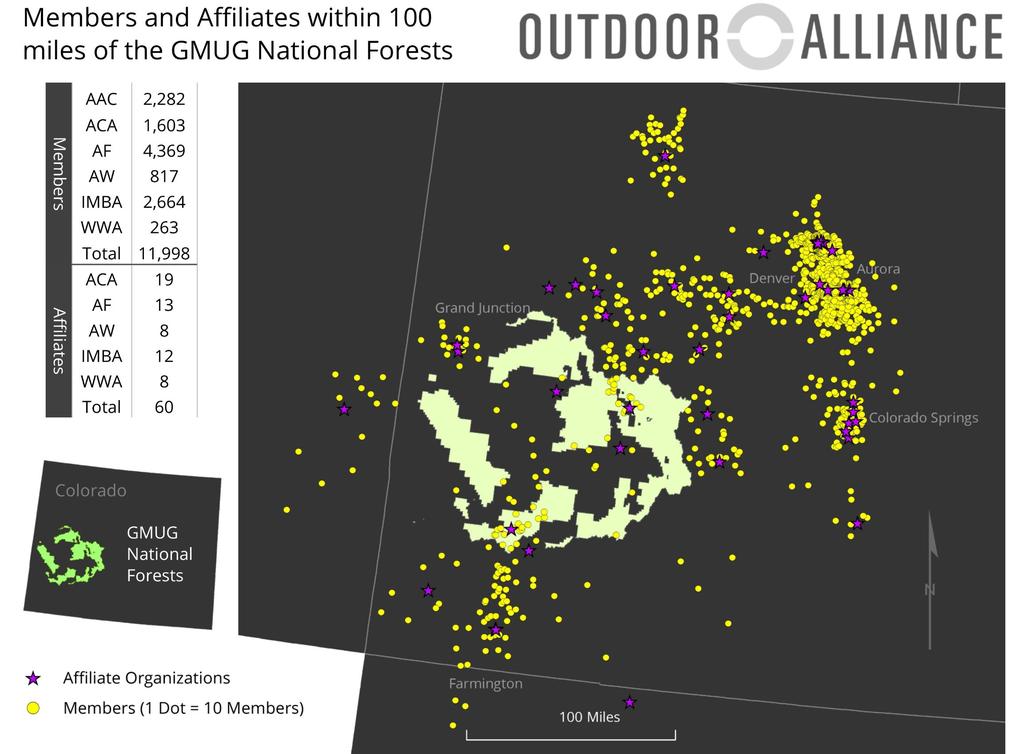
1 August 30th, 2017 Grand Mesa, Uncompahgre and Gunnison National Forests Attn: Plan Revision Team 2250 South Main Street Delta, CO Re: GMUG Forest Plan Revision Assessment Comments Dear Plan Revision Team, Thank you for taking the time to consider these Assessment Phase joint comments from Outdoor Alliance and Outdoor Alliance Colorado regarding the Grand Mesa, Uncompahgre, and Gunnison Forest Plan Revision # Outdoor Alliance is a coalition of eight member-based outdoor recreation organizations: American Whitewater, American Canoe Association, Access Fund, International Mountain Bicycling Association, Winter Wildlands Alliance, The Mountaineers, the American Alpine Club, and the Mazamas. With a presence in all 50 states, Outdoor Alliance has a collective membership of nearly 200,000 individuals and a national network of more than 1,000 local clubs. Together, our network reaches nearly 400,000 passionate outdoor enthusiasts. For the past ten years, Outdoor Alliance has been bringing together the voices of paddlers, mountain bikers, hikers, climbers, and backcountry skiers to conserve America s public lands and protect the human-powered outdoor experience. Our work is unique because it seeks to balance both conservation and sustainable recreational access. In Colorado, this work is achieved in part through our regional partnership Outdoor Alliance Colorado a coalition of five member-based organizations representing the state s humanpowered outdoor recreation community. The coalition includes Access Fund, Colorado Mountain Club, American Whitewater, Colorado Mountain Bike Association, and the American Alpine Club. The Outdoor Alliance community has the strength of 60 affiliated organizations and 12,000 members within 100 miles of the GMUG forest and represents the broader interests of the millions of Coloradans who climb, paddle, mountain bike, and backcountry ski and snowshoe on our state s public lands, waters, and snowscapes. Because of the importance of addressing recreation spatially rather than merely programatically, the Assessment is a key part of the planning process. Forest Planners must have information that enables them to take account of where people go on their National Forests, when they go there, and why. Recreation does not occur at random across Forests; rather, recreationists are drawn by unique and particular attributes like aesthetic trail qualities; whitewater difficulty, quality, and hydrology; snow conditions and topography; and rock quality
2 and geology. To appropriately develop required plan components like geographic and management areas--as well as to complete the Wild and Scenic and Wilderness inventories-- planners must begin with detailed spatial and qualitative information on recreational resources. Outdoor Alliance and Outdoor Alliance Colorado would like to offer our assistance in the collection of this essential data. The Importance of Outdoor Recreation in Colorado Colorado s unparalleled natural resources and outdoor recreation opportunities are defining features of our state they are Colorado s heritage and a primary reason individuals and businesses make Colorado home. Colorado s State Comprehensive Outdoor Recreation Plan underscored the importance of the outdoors to Coloradans stating, Overwhelmingly, 90 percent of Coloradans participated in some form of outdoor recreation in Colorado over the past year. Their survey also revealed that, 60 percent of Coloradans will either greatly increase or somewhat increase their participation in outdoor recreation over the next five years. 1 Colorado is a testament that building a strong and resilient economy starts with creating a great community where people want to live. The top reasons people choose to live in Colorado are the state s clean environment, access to public lands and outdoor recreation opportunities, and residents ability to maintain a healthy outdoor lifestyle. 2 The result is evident in the Outdoor Industry Association s 2017 report that found the outdoor recreation economy contributes $28 billion dollars and 229,000 jobs to the Colorado economy and $9.7 billion dollars to Coloradans in the form of wages and salaries. 3 Colorado s outdoor recreation opportunities are an economic powerhouse that makes the state a prime tourism destination and an amazing place to live, work and to raise our families. Outdoor Recreation in the Grand Mesa Uncompahgre and Gunnison National Forests The Grand Mesa Uncompahgre and Gunnison (GMUG) National Forests stretch from the high Sawatch Range peaks of the Continental Divide to the plateaus and canyons of Colorado s Western Slope encompassing some of the most remote and beautiful landscapes in Colorado. In their combined three million acres of land, the Forests house 3,000 miles of trails and routes, 300 lakes, and 3,600 miles of rivers and streams. Outdoor Alliance's GIS Lab has identified 43 miles of hiking, 932 miles of hiking and equestrian, 96 miles of mountain biking, 532 miles of hiking, equestrian and mountain biking, 136 miles of cross-country and backcountry ski winter trails, over 924 climbing routes, and 49 miles of paddling as high-value recreation sites. The GMUG National Forests count among their neighbors some of Colorado s most iconic outdoor recreation meccas including Crested Butte, Gunnison, Grand Junction, and Telluride. 1 Strategies for Sustaining Colorado s Outdoor Heritage; 2014 Colorado Statewide Comprehensive Outdoor Recreation Plan (2014), Colorado College, Conservation in the West Poll (2015). 3 Outdoor Industry Association, Colorado's Outdoor Recreation Economy Report, (2017).
3 to recreate on the world class Continental Divide, 401, and Teocalli Ridge trails; to summit alpine peaks like Sneffels and Wilson; to ice climb classic routes in the Ames area; to rock climb at traditional and sport climbing areas such as the Ophir and Pipeline Walls; and to find solitude in the Collegiate Peaks, Maroon Bells-Snowmass, and the Forests eight other Wilderness areas. Outdoor Alliance s grassroots network in Colorado and GIS inventory of landscapes and recreation may be helpful to the Forest Service in protecting this treasured region through the Forest Planning process. GMUG Forest Plan Assessment Considerations We applaud the Forest Service for implementing the 2012 Planning Rule and expanding the role of public process in guiding the development of Forest Plans. Outdoor Alliance participated in designing the new Planning Rule and continues to prioritize engaging in its implementation. As the Forest Service seeks to secure improved management the Grand Mesa, Uncompahgre, and Gunnison National Forests through the Forest Plan revision process, we urge the agency s consideration of the following in the Assessment Phase of the Forest Plan Revision Process: The Draft and Final Forest Plan should prioritize recreational access. The GMUG s approximately 3.4 million visitors are a testament to the need to prioritize the outdoor recreation experience in these Forests. Human-powered recreation is growing in both summer (including climbing, hiking, paddling, mountain biking) and winter (including alpine touring, splitboarding, telemarking, cross country skiing, snowshoeing and winter mountaineering). Protect and manage key areas for human-powered recreation. In order to minimize impacts to sensitive lands, waters, snowscapes and habitats, and to reduce user conflicts, please consider new recommended landscape protections and designations, including: o Management and geographic areas focused on recreation such as those described in the Forest Plan Revision for the Colville, and the Okanogan- Wenatchee National Forests Briefing: Special Areas and Management Areas (attached); o New Eligible Wild and Scenic River protections; o New Recommended Wilderness protections; and o Other potential Congressional designations, including potential National Recreation Areas, aimed at protecting human-powered recreation experiences and opportunities on certain exceptional landscapes. Leverage volunteer groups for trail maintenance. Trails and recreation sites are heavily used and in dire need of maintenance. Groups of active volunteers exist within local communities to help with this type of work, which needs to be better planned, coordinated, and executed. The National Forest Trails System Stewardship Act of 2016 calls on the Forest Service to significantly increase the use of volunteer stewards. The GMUG could be a leader in this effort.
4 Promote sustainable, recreation-based jobs and recognize the role of outdoor recreation in attracting businesses and workers across industries. Locals and visitors alike come to hike, climb, camp, bike, and ski in the GMUG s wild backcountry. These recreational amenities are essential to local economies and should be a prime consideration in the development of the revised Forest Plan. Map and preserve wild roadless lands These lands are essential to wildlife conservation and recreation. Habitat corridors for migration and movement should be mapped and preserved. Roads should be managed appropriately to minimize the spread of invasive weeds, habitat loss, and degradation of water quality, but management should be done in a manner cognizant of recreation needs such as access to trailheads and river access points. Engage and collaborate with local stakeholders. Exemplary management of the National Forests must be locally-informed and collaboratively developed and backed. Specifically, the Forest Partnership collaborative stakeholder group employed in the Nantahala and Pisgah National Forests Plan Revision is a successful model to draw inspiration from. Please also consider meeting directly with local representatives of Outdoor Alliance s Colorado regional partnership including Access Fund, Colorado Mountain Club, American Whitewater, Colorado Mountain Bike Association, and the American Alpine Club. Collaboration with the Outdoor Recreation Community In addition to the above recommendations, Outdoor Alliance would like to offer our community s assistance to help the planning team balance sustainable outdoor recreation and conservation with other uses such as grazing and energy and mineral extraction. Outdoor Alliance would like to collaboratively work on solving recreation related issues, and specifically offer to do the following: 1. Provide GIS recreation data and maps to the Forest Service to ensure that the recreation and conservation voices are backed by data in the planning process. This data has been provided to the GMUG planning team s GIS specialists in tandem with these comments. An online version may be found at: 2. Host maps from disparate stakeholders to facilitate location-based decision making. During the Nantahala and Pisgah National Forests Plan revision, Outdoor Alliance hosted an ArcGIS online geospatial dataset from all partners. The data overlays allowed stakeholders to pinpoint potential conflicts and focus conversation on the small amount of areas where compromise was needed greatly simplifying the process. Examples can be found at: 3. Raise awareness of the Forest Planning process and generate comments in support of a strong Draft Plan through events, communications content, and media outreach to local
5 communities and the Outdoor Alliance coalition. 4. Host an outdoor recreation roundtable in partnership with the Forest Service to bring Outdoor Alliance affiliated organizations and their community leaders into direct and collaborative discussion with GMUG planning staff (recognizing that the Forests are still developing strategy for how and when in the planning process to engage such groups). 5. Build a grassroots foundation for protections beyond the Forest Plan, including opposition to public land transfer, conceptual plan for future Wilderness, Wild and Scenic, and possibly other Congressional designations, with the goal of broad public support. We look forward to collaborating with the GMUG planning team to help protect the 3,161,900 acres of the Grand Mesa Uncompahgre and Gunnison National Forests and the recreation and local economies which depend upon these lands and waters. Best Regards, Jason Bertolacci Founding Member Outdoor Alliance Colorado Louis Geltman Policy Director Outdoor Alliance cc: Adam Cramer, Executive Director, Outdoor Alliance Nathan Fey, Colorado River Program Director, American Whitewater J.B. Haab, FRCS Field Manager, Access Fund Julie Mach, Conservation Director, Colorado Mountain Club John McCauley, Regional Organizer, Outdoor Alliance Maria Millard Povec, Policy & Advocacy Director, American Alpine Club Gary Moore, Executive Director, Colorado Mountain Bike Association
6 BACKGROUND ON OUTDOOR ALLIANCE Outdoor Alliance is the only organization in the U.S. that unites the voices of outdoor enthusiasts to protect public lands and waters and ensure they are managed in a way that embraces the human-powered experience. Our authentic, place-based, passionate community is comprised of members that are historically and socially distinct from those in the traditional environmental community. On average, they are 30 years younger and bipartisan an unusual and extremely powerful combination in current-day conservation advocacy. Our memberships have high rates of voter registration and are seven times more likely than comparable members of environmental groups to engage on complicated civic matters. Outdoor Alliance leads a coalition to address the conservation and access issues of greatest importance to the human-powered outdoor recreation community. We work to: Transform outdoor enthusiasts into outdoor advocates We connect millions of climbers, paddlers, cross-country skiers, hikers, and mountain bikers to advance a powerful voice for outdoor recreation. We work with our six regional networks, our seven member organizations, and dozens of outdoor businesses and partners to educate, engage and mobilize these outdoor enthusiasts with policy and advocacy content that is savvy, authentic, and inclusive. Secure meaningful protections for public lands that have significant conservation and social value Outdoor Alliance identifies public lands with high recreation value that are eligible for further administrative or legislative protection, and works to secure their meaningful protection. We prioritize not only wild places but also those closer to where people live to ensure our work is relevant to a diverse population of outdoor users. Lead the outdoor recreation community as the trusted voice on public land conservation policy We recognize that our public lands are home to different users and activities, from recreation to wildlife preservation to development. Our efforts to monitor, analyze, and respond to regulatory and legislative policies are bolstered by cutting-edge data from our GIS lab and innovative advocacy tools that results in the unmatched ability to unify and mobilize our community.

 172 XC & BC Skiing 136 Colorado GMUG")
7 Recreation Inventory of the GMUG National Forests Recreation Miles Hiking 43 Hiking, Equestrian 932 Hiking, Mountain Biking, Equestrian 532 Mountain Biking 96 Paddling 49 Rock Climbing (Cliffs & Boulders) 172 XC & BC Skiing 136 Colorado GMUG National Forests
8 12
9 Special Areas and Management Areas Forest Plan Revision for the Colville, and the Okanogan-Wenatchee National Forests August 2008 Briefing: Special Areas and Management Areas 1 This paper presents further information on options for management of lands not included in a preliminary administrative recommendation for wilderness. The options fall under the following broad types: Special areas - areas designated by law or statute or through administrative process. Management areas - separate areas of a Forest designated in the forest plan where different uses and activities are generally suitable. Special Areas vs. Management Areas Key Difference = who makes the designation decision The time, effort, and complexity vary for designating special areas and management areas. While not absolute, management areas generally take the least effort and time to designate, while administratively designated special areas take more time and effort, and special areas designated by Congress typically take the most time and effort. The following table shows the authority that makes the designations. Designation SPECIAL AREAS: Areas designated by law Areas administratively designated MANAGEMENT AREAS Designation Authority Congress Secretary of Agriculture or a Forest Service official Forest Supervisor Categories of special areas and who has the authority to designate them are shown in the table on page 5. Note that statutorily designated areas can also be proposed to Congress by the public outside the plan revision process. 1 Additional information on special areas and management areas may be found in Forest Service Handbook , Chapter 10 Colville, Okanogan-Wenatchee Forest Plan Revision 1 of 5
10 Special Areas and Management Areas Special Areas Certain limited areas of National Forest System lands may have outstanding or unique examples of plant and animal communities, geological features, scenic grandeur, or other special attributes that merit special management. These areas are designated by law or may be designated administratively as special areas. Designated areas are managed to emphasize recreational and other specific related values. Other uses are permitted in the areas to the extent that these uses are in harmony with the purpose for which the area was designated. The law or decision designating each area provides specific objectives and guidelines for management of each area. No provision in law requires the Forest Service to inventory, evaluate, and recommend special areas for designation, with the exception of wilderness and wild and scenic rivers. Forest plans may identify areas as special for various reasons without a formal designation. Special areas, such as botanical areas or significant caves may be designated by the Responsible Official in approving a plan revision. Such designations are not final decisions approving projects and activities. Forest plans include special areas already designated by law (like Salmo- Priest Wilderness Area) or administrative process, such as Sherman Pass National Scenic Byway on Colville National Forest. Special Areas Designated by Law or Statute Of all the possible special areas, there has been public interest in National Recreation Areas. National Recreation Areas (NRAs) are designated through law passed by Congress. In order to qualify as an NRA these areas have outstanding combinations of outdoor recreation opportunities, aesthetic attractions, and proximity to potential users. They may also have cultural, historical, archaeological, pastoral, wilderness, scientific, wildlife, and other values contributing to public enjoyment. The uses and activities allowed (the desired condition) within an NRA depends on the law designating the area and can vary widely. Some notable local examples include the following: Examples of National Recreation Areas (areas designated by law or statute) Mt. Baker National Recreation Area The Mount Baker National Recreation Area was created in conjunction with the 1984 Washington Wilderness Act to accommodate and preserve the winter snowmobile use of the Mount Baker area in and around Schriebers Meadow. To preserve this use, management of the area focuses on providing snowmobile and cross-country skiing opportunities during the winter and non-motorized recreational uses during the summer season. The Mount Baker National Recreation Area differs from the adjacent Mount Baker Wilderness by allowing the use of snowmobiles when snow levels are sufficient (greater than two feet at Schriebers Meadow Trailhead). Colville, Okanogan-Wenatchee Forest Plan Revision 2 of 5
11 Special Areas and Management Areas Hells Canyon National Recreation Area The Hells Canyon National Recreation Area was established by Congress on December 31, 1975 under Public Law The act that created the HCNRA states that to assure that the natural beauty, and historical and archaeological values of the Hells Canyon area and the seventy-one-mile segment of the Snake River between Hells Canyon Dam and the Oregon- Washington border, together with portions of certain of its tributaries and adjacent lands, are preserved for this and future generations, and that the recreational and ecologic values and public enjoyment of the area are thereby enhanced, there is hereby established the Hells Canyon Recreation Area. Sawtooth National Recreation Area The Sawtooth National Recreation Area's (SNRA) 756,000 acres are part of the Sawtooth National Forest in Idaho. The SNRA was established by Congress in 1972 "... in order to assure the preservation and protection of the natural, scenic, historic, pastoral, and fish and wildlife values and to provide for the enhancement of the recreational values associated therewith..." At the same time, the 217,000-acre Sawtooth Primitive Area was designated as the Sawtooth Wilderness. Special Areas Designated Administratively Of all the special areas that are administratively designated, current interest to the public are the special interest areas. These types of special areas are designated to protect and manage for public use and enjoyment. They are areas with scenic, recreational, geological, botanical, zoological, paleontological, archaeological, or other special characteristics or unique values. Selecting one of the above examples of special interest areas, a recreational area is a unit of land that has been administratively designated for particular recreation opportunities or activities such as hiking, rock hounding, recreational mining, photography, or other special activity. Recreational areas are designated administratively, meaning this special area can be designated by the Regional Forester if less than 100,000 acres, and by the Secretary of Agriculture if greater than that. Local examples of administratively designated special areas range from the one-acre proposed Columbia Mountain Lookout archaeological special interest area on Colville National Forest to the 48,000-acre Teanaway recreational special interest area on the Okanogan- Wenatchee National Forest. As can be seen from the description of a recreational area, the uses and activities allowed within the area are dependent on the desired condition for the area. The management emphasis of a recreational area would be for the kind of recreational opportunity provided by the area. Other uses, such as livestock grazing, are permitted in the areas to the extent that these uses are in harmony with the desired condition for which the area was designated. In the forest plan such special areas are assigned a unique set of management guidance that provides for the recreational opportunity and can constrain other uses through a set of guidelines. Colville, Okanogan-Wenatchee Forest Plan Revision 3 of 5
12 Special Areas and Management Areas Management Areas Besides special areas, a forest plan identifies separate areas similar to county or city zoning where a distinct set of management guidance is applied. These are called management areas. No set list of management areas exists as for special areas. Rather, management areas are defined and developed in a forest plan. Like special areas, management areas have desired conditions and guidelines specific to those areas. Unlike special areas, those desired conditions and guidelines are not specified by law, statute, or administrative direction. Management area guidance is developed by the particular national forest in response to social, ecological, and economic concerns and conditions. National Forest System lands are generally suitable for a variety of uses such as outdoor recreation, viewing scenery, livestock grazing, timber production, fisheries and wildlife, cultural and heritage resource interpretation, and watershed purposes. Management areas arrange these various uses across the forest in varying levels of intensity. Management areas tend to encompass large areas (50,000 acres plus) of a Forest and often cross Ranger District boundaries. Conclusion Areas not designated for wilderness may be managed to achieve a wide variety of desired conditions. The desired conditions may be framed using a special area or a management area designation. The time and effort to designate areas varies by who has authority to designate an area and the process. Past experience shows that the process to designate special areas through Congress (wilderness or national recreation areas) or by the Secretary of Agriculture (large recreation special interest areas) generally takes longer than those areas designated by the responsible official (Regional Forester or the Forest Supervisor). All special areas, whether a one-acre special interest area or a very large wilderness area, come with a set of rules on how they are managed. The rules and their flexibility vary with the type of special area. Colville, Okanogan-Wenatchee Forest Plan Revision 4 of 5
13 Special Areas and Management Areas Special Areas Special Areas - designating official and guidance cross-reference Statutorily Designated Areas National Monument National Recreation Area National Scenic Area National Trails National Scenic Trails National Historic Trails Wild and Scenic River Wilderness, or Wilderness Study Areas Highway Systems, Interstate and National Responsible Official Designated Areas Designation Authority Presidential Executive order or Congressional act designates Congressional act designates Congressional act designates Congressional act designates Congressional act designates Congressional act designates Congressional act established process Secretary of the Department of Transportation approves Additional Guidance Location FSM 2371 FSM 2371 FSM 2371 FSM FSM 1924 & 2354 FSH FSM 1923 & 2320 FSH CFR part 470 Botanical Area Responsible Official Designates FSM 2372 Geological Area Responsible Official Designates FSM 2372 Administratively Designated Areas Experimental Forest or Range National Natural Landmark National Historic Landmark Recreation Areas Research Natural Area Scenic Byway - Forest Service Scenic Byway - National Significant Caves National Recreation Trails with concurrence of Station Director Chief designates Secretary of Interior designates Secretary of Agriculture designates Regional Forester designates, with concurrence of Station Directors Chief designates Federal Highway Administration designates Regional Forester designates FSM 4062 FSM 2373 FSM CFR FSM 2360 FSM 4063 None None 36 CFR part 290 FSM Colville, Okanogan-Wenatchee Forest Plan Revision 5 of 5
Wilderness Process #NP-1810: Your letter ID is NP September 5, 2018
 Wilderness Process #NP-1810: Your letter ID is NP-1810-2602-96 September 5, 2018 RE: GMUG Wilderness Evaluation Revised Evaluation Criteria and Draft Report Forest Revision Planning Team: The Continental
RE: Access Fund Comments on Yosemite National Park Wilderness Stewardship Plan, Preliminary Ideas and Concepts
 September 30, 2016 Superintendent Yosemite National Park Attn: Wilderness Stewardship Plan P.O. Box 577 Yosemite, CA 95389 RE: Access Fund Comments on Yosemite National Park Wilderness Stewardship Plan,
Continental Divide National Scenic Trail Legislative History and Planning Guidance
 Continental Divide National Scenic Trail Legislative History and Planning Guidance Legislation, Policy, and Direction Regarding National Scenic Trails The National Trails System Act, P.L. 90-543, was passed
April 10, Mark Stiles San Juan Public Lands Center Manager 15 Burnett Court Durango, CO Dear Mark,
 Mark Stiles San Juan Public Lands Center Manager 15 Burnett Court Durango, CO 81301 Dear Mark, We are pleased to offer the following comments on the draft San Juan Public Lands Center management plans
Whitefish Range Partnership Tentatively Approved by WRP 11/18/2013!Rec. Wilderness Page 1
 Whitefish Range Partnership Tentatively Approved by WRP 11/18/2013!Rec. Wilderness Page 1 Recommended Wilderness Background The Whitefish Range has a long management and legislative history associated
Wilderness Character and Wilderness Characteristics. What s the difference? Why does it matter?
 Introduction Wilderness Character and Wilderness Characteristics What s the difference? Why does it matter? The terms wilderness character and wilderness characteristics are sometimes used interchangeably
TESTIMONY ON THE UTAH PUBLIC LANDS INITIATIVE ACT (H.R. 5780) September 14, 2016
 September 14, 2016") TESTIMONY ON THE UTAH PUBLIC LANDS INITIATIVE ACT (H.R. 5780) September 14, 2016 For consideration by the Subcommittee on Federal Lands United States House of Representatives Submitted by Erik Murdock,
TESTIMONY ON THE UTAH PUBLIC LANDS INITIATIVE ACT (H.R. 5780) September 14, 2016 For consideration by the Subcommittee on Federal Lands United States House of Representatives Submitted by Erik Murdock,
Securing Permanent Protection for Public Land
 Securing Permanent Protection for Public Land Tools for Wyoming Advocates Paul Spitler* The Wilderness Society * I am a wilderness policy expert, not a powerpoint expert! Platform and Resolutions of the
Sothern Appalachian Plant Society Back Country Horsemen of Blue Ridge
 Sothern Appalachian Plant Society Back Country Horsemen of Blue Ridge December 7, 2015 James Melonas, Interim Forest Supervisor National Forests in North Carolina 160 Zillicoa St. Suite A Asheville, NC
13.1 REGIONAL TOURISM ISSUES AND SUMMARY OF FINDINGS
 13 REGIONAL TOURISM T he County of Mariposa s recreation needs and facilities fall within two categories: regional tourism and local recreation. This Element focuses on regional tourism issues related
TONGASS NATIONAL FOREST
 TONGASS NATIONAL FOREST UNITED STATES DEPARTMENT OF AGRICULTURE-FOREST SERVICE Contact: Dennis Neill Phone: 907-228-6201 Release Date: May 17, 2002 SEIS Questions and Answers Q. Why did you prepare this
Preferred Recreation Recommendations Stemilt-Squilchuck Recreation Plan March 2018
 Preferred Recreation Recommendations Stemilt-Squilchuck Recreation Plan March 2018 Below are the recommended recreation ideas and strategies that package together the various recreation concepts compiled
Hermosa Area Preservation The Colorado Trail Foundation 4/11/2008
 Hermosa Area Preservation The Colorado Trail Foundation 4/11/2008 Legend d o Tr ail NPA - National Protection Area ra NCA - National Conservation Area o e C Th The Colorado Trail lo FS inventoried Roadless
5.0 OUTDOOR RECREATION OPPORTUNITIES AND MANAGEMENT
 5.0 OUTDOOR RECREATION OPPORTUNITIES AND MANAGEMENT 5.1 Introduction This section describes the range of recreational activities that currently take place in Marble Range and Edge Hills Parks, as well
WASHINGTON STATE PARKS LAND CLASSIFICATION SYSTEM
 WASHINGTON STATE PARKS LAND CLASSIFICATION SYSTEM Administrative Code Establishing Land Classification System WAC 352-16-020 Land classification system. State park areas are of statewide natural, cultural,
Dear Reviewing Officer:
 From: To: Subject: Date: Attachments: Peter Hart FS-r02admin-review Objection Re: Maroon Bells Snowmass Wilderness Overnight Visitor Use Management Plan Monday, August 14, 2017 8:38:01 PM Final Objection
November 6, RE: OBJECTION Regarding the Revised Colville Forest Plan. To Objection Reviewing Officer:
 305 N. 83 rd Street Seattle, WA 98103 206-633-1992 www.wawild.org info@wawild.org November 6, 2018 USDA Forest Service Attn: Chris French, Objection Reviewing Officer 1400 Independence Ave. SW, EMC-PEEARS,
Proposal to Redevelop Lower Kananaskis River-Barrier Lake. Bow Valley Provincial Park. Frequently Asked Questions
 Proposal to Redevelop Lower Kananaskis River-Barrier Lake Bow Valley Provincial Park Frequently Asked Questions What is being proposed? What are the details of the proposal? Where is the project area located?
UNITED STATES DEPARTMENT OF THE INTERIOR BUREAU OF LAND MANAGEMENT MANUAL TRANSMITTAL SHEET
 Form 1221-2 (June 1969) UNITED STATES DEPARTMENT OF THE INTERIOR BUREAU OF LAND MANAGEMENT MANUAL TRANSMITTAL SHEET Release 8-83 Date Subject 8353 Trail Management Areas Secretarially Designated (Public)
Appendix A BC Provincial Parks System Goals
 Appendix A BC Provincial Parks System Goals The British Columbia Provincial Parks System has two mandates: To conserve significant and representative natural and cultural resources To provide a wide variety
WORKSHEET 1 Wilderness Qualities or Attributes Evaluating the Effects of Project Activities on Wilderness Attributes
 WORKSHEET 1 Wilderness Qualities or Attributes Evaluating the Effects of Project Activities on Wilderness Attributes Date: 3/7/2017 Roadless Area: Ruby South Description of Project Activity or Impact to
$850,000 Awarded to 20 Organizations
 $850,000 Awarded to 20 Organizations The Conservation Alliance is pleased to fund the following organizations to support their efforts to protect wild lands and waterways for their habitat and recreation
Fixed Anchors. Non-Wilderness Management Areas
 Access Fund-Carolina Climbers Coalition Proposals Submitted for Consideration and Support to the National Forest Forum and Nantahala- Pisgah Forest Partnership July 25, 2017, Updated July 28, 2017 Fixed
White Mountain National Forest Saco Ranger District
 United States Department of Agriculture Forest Service White Mountain National Forest 33 Kancamagus Highway Conway, NH 03818 Comm: (603) 447-5448 TTY: (603) 447-3121 File Code: 1950 Date: February 26,
Restore and implement protected status that is equivalent, or better than what was lost during the mid-1990 s
 THE ROSSLAND RANGE, OLD GLORY AREA. Executive summary. The Friends of the Rossland Range Society, on behalf of the local outdoor community, seeks to accomplish the following with respect to the Old Glory
Central Cascades Wilderness Strategies Project
 Central Cascades Wilderness Strategies Project Wilderness is Unique What makes designated Wilderness different from other national forest lands? Wilderness Act of 1964 to assure that an increasing population
Decision Memo Broken Wheel Ranch Equestrian Outfitter Special-Use Permit Proposed Action
 Decision Memo Broken Wheel Ranch Equestrian Outfitter Special-Use Permit USDA Forest Service Mississippi Bluffs Ranger District, Shawnee National Forest Jackson and Union Counties, Illinois Proposed Action
Connie Rudd Superintendent, Black Canyon of the Gunnison National Park
 National Park Service U.S. Department of the Interior Black Canyon of the Gunnison National Park and Curecanti National Recreation Area Information Brochure #1 Wilderness and Backcountry Management Plan
Proposed Action. Payette National Forest Over-Snow Grooming in Valley, Adams and Idaho Counties. United States Department of Agriculture
 United States Department of Agriculture Forest Service January 2012 Proposed Action Payette National Forest Over-Snow Grooming in Valley, Adams and Idaho Counties Payette National Forest Valley, Adams
S. 37, Forest Jobs and Recreation Act (FJRA)
") Testimony of Jeremy Fancher, International Mountain Bicycling Association Before the U.S. Senate Committee on Energy and Natural Resources Subcommittee on Public Lands, Forests, and Mining Hearing on Misc.
Testimony of Jeremy Fancher, International Mountain Bicycling Association Before the U.S. Senate Committee on Energy and Natural Resources Subcommittee on Public Lands, Forests, and Mining Hearing on Misc.
FINAL TESTIMONY 1 COMMITTEE ON RESOURCES UNITED STATES HOUSE OF REPRESENTATIVES. July 13, 2005 CONCERNING. Motorized Recreational Use of Federal Lands
 FINAL TESTIMONY 1 STATEMENT OF DALE BOSWORTH CHIEF Of the FOREST SERVICE UNITED STATES DEPARTMENT OF AGRICULTURE Before the SUBCOMMITTEE ON FORESTS AND FOREST HEALTH And the SUBCOMMITTEE ON NATIONAL PARKS,
2.0 PARK VISION AND ROLES
 2.0 PARK VISION AND ROLES 2.1 Significance in the Protected Area System Marble Range and Edge Hills provincial parks protect 6.8% of the Pavillion Ranges Ecosection, which is located in the Southern Interior
Map 1.1 Wenatchee Watershed Land Ownership
 Map 1.1 Wenatchee Watershed Land Ownership Map 1.1 Wenatchee Watershed Land Ownership The Wenatchee watershed lies in the heart of Washington state in Chelan County. Just larger than the state of Rhode
Creating a User-Driven Long-Distance OHV Trail Through Partnering
 Joseph Raffaele Outdoor Recreation Planner U.S. Bureau of Land Management Yuma, Arizona Creating a User-Driven Long-Distance OHV Trail Through Partnering BLM is a multiple-use land management agency within
Appalachian Mountain Club
 Appalachian Mountain Club January 30, 2013 Groton Planning Board 754 North Groton Road Groton, NH 03241 Re: Re-opened public hearing regarding a request by EDP Renewables (Lessee), EXPX2/MAXAM (Owner)
Pacific Northwest National Scenic Trail. USDA-Forest Service Pacific Northwest and Northern Regions April 2014
 Pacific Northwest National Scenic Trail USDA-Forest Service Pacific Northwest and Northern Regions April 2014 Today s trip 1. What is a National Scenic Trail 2. About the Pacific Northwest Trail 3. Planning
BACKCOUNTRY TRAIL FLOOD REHABILITATION PROGRAM
 BACKCOUNTRY TRAIL FLOOD REHABILITATION PROGRAM Backcountry Trail Flood Rehabilitation A June 2013 Flood Recovery Program Summary In June 2013, parts of Southern Alberta were devastated from significant
Proposed Scotchman Peaks Wilderness Act 2016 (S.3531)
") 1 Proposed Scotchman Peaks Wilderness Act 2016 (S.3531) Frequently Asked Questions PLACE Where is the area that would be designated as Wilderness? The lands outlined in S.3531 lie within Idaho along its
1 Proposed Scotchman Peaks Wilderness Act 2016 (S.3531) Frequently Asked Questions PLACE Where is the area that would be designated as Wilderness? The lands outlined in S.3531 lie within Idaho along its
Special Recreation Management Areas Extensive Recreation Management Areas Public Lands Not Designated as Recreation Management Areas
 From the Proposed RMP: Special Recreation Management Areas SRMAs are an administrative unit where the existing or proposed recreation opportunities and recreation setting characteristics are recognized
PROPOSED ACTION South 3000 East Salt Lake City, UT United States Department of Agriculture
 United States Department of Agriculture Forest Service Uinta-Wasatch-Cache National Forest Salt Lake Ranger District 6944 South 3000 East Salt Lake City, UT 84121 801-733-2660 File Code: 1950/2300 Date:
Thank you for the opportunity to comment on the proposed action to add trails and trailheads to the Red Rock District trail system.
 July 14, 2010 Jennifer Burns Red Rock Ranger District PO Box 20429 Sedona, AZ 86341 Flagstaff Biking Organization PO Box 23851 Flagstaff, AZ 86002 Dear Jennifer- Thank you for the opportunity to comment
PROUDLY BRINGING YOU CANADA AT ITS BEST. Management Planning Program NEWSLETTER #1 OCTOBER, 2000
 PROUDLY BRINGING YOU CANADA AT ITS BEST VUNTUT NATIONAL PARK Management Planning Program NEWSLETTER #1 OCTOBER, 2000 INTRODUCTION This newsletter launches the development of the first management plan for
Decision Memo for Desolation Trail: Mill D to Desolation Lake Trail Relocation
 for Salt Lake County, Utah Uinta-Wasatch-Cache National Forest Salt Lake Ranger District 1. Background The present location of the Desolation Trail (#1159) between Mill D and Desolation Lake follows old
Pillar Park. Management Plan
 Pillar Park Management Plan January 2014 Pillar Park Management Plan Approved by: Jeff Leahy Regional Director Thompson Cariboo Region BC Parks January 9, 2014 Date Brian Bawtinheimer Executive Director
Sawtooth National Forest Fairfield Ranger District
 United States Department of Agriculture Forest Service Sawtooth National Forest Fairfield Ranger District P.O. Box 189 Fairfield, ID. 83327 208-764-3202 Fax: 208-764-3211 File Code: 1950/7700 Date: December
Tracy Ridge Shared Use Trails and Plan Amendment Project
 Tracy Ridge Shared Use Trails and Plan Amendment Project Scoping Document Forest Service Allegheny National Forest Bradford Ranger District McKean, County, Pennsylvania In accordance with Federal civil
As outlined in the Tatshenshini-Alsek Park Management Agreement, park management will:
 Management Strategy General Strategy The priority management focus for the park is to ensure that its internationally significant natural, cultural heritage and recreational values are protected and that
National Wilderness Steering Committee
 National Wilderness Steering Committee Guidance White Paper Number 1 Issue: Cultural Resources and Wilderness Date: November 30, 2002 Introduction to the Issue Two of the purposes of the National Wilderness
Wilderness Stewardship Plan Scoping Newsletter Winter 2013
 Olympic National Park National Park Service U.S. Department of the Interior Wilderness Stewardship Plan Scoping Newsletter Winter 2013 Dear Friends and Neighbors, The Olympic Wilderness was established
SOCIAL CONFLICT BETWEEN MOTORIZED AND NON-MOTORIZED RECREATIONAL ACTIVITIES.
 SOCIAL CONFLICT BETWEEN MOTORIZED AND NON-MOTORIZED RECREATIONAL ACTIVITIES. There is a great disparity in opinions about the effects on a person s recreational experience when they encounter others on
National Park Service Wilderness Action Plan
 National Park Service U.S. Department of the Interior National Park Service Wilderness Action Plan National Wilderness Steering Committee National Park Service "The mountains can be reached in all seasons.
Draft Revised Land Management Plan and DEIS Comments
 December 28, 2017 Dan Dallas, Forest Supervisor Rio Grande National Forest Attn: Rio Grande Forest Plan Revision 1803 W. U.S. Highway 160 Monte Vista, CO 81144 rgnf_forest_plan@fs.fed.us Draft Revised
Expanding Settlement Growing Mechanization
 The Wilderness Act of 1964 Expanding Settlement Growing Mechanization Versus Wilderness protection is paper thin, and the paper should be the best we can get that upon which Congress prints its Acts. David
2014 STATEWIDE COMPREHENSIVE OUTDOOR RECREATION PLAN
 2014 STATEWIDE COMPREHENSIVE OUTDOOR RECREATION PLAN SUSTAINING COLORADO S OUTDOOR RECREATION FUTURE SECTION 1: INTRODUCTORY INFORMATION WHAT IS THE SCORP? The SCORP update is required every five years
COUNTY COMPREHENSIVE PLAN
 50 : Policy Statement Lewis County has a unique and attractive rural character, which makes it a wonderful place to visit and explore. The region abounds with recreation opportunities that attract visitors
Figure 1-Example of terracing from livestock
 To: District Ranger Matt Janowiak April 3, 2016 P.O. Box 439, Bayfield, CO 81122 comments-rocky-mountain-san-juan-columbine@fs.fed.us From: Greg Warren Golden, CO 80401 Please consider the following comments
Federal Land and Resource Management: A Primer 1
 Federal Land and Resource Management: A Primer 1 RS20002 Coordinated by Ross W. Gorte Natural Resource Economist and Policy Specialist Environment and Natural Resources Policy Division December 22, 1998
The Vision for the San Juan Islands Scenic Byway
 The Vision for the San Juan Islands Scenic Byway 2 Judd Cove, Orcas Island, Courtesy of Kurt Thorson (kurtthorson.com) and San Juan County Land Bank Vision for the San Juan Islands Scenic Byway The San
System Group Meeting #1. March 2014
 System Group Meeting #1 March 2014 Meeting #1 Outcomes 1. Understand Your Role 2. List of Revisions to Existing Conditions 3. Information Sources Study Area The Purpose of Mountain Accord is to Preserve
BACKSTORY & MMBA RECOMMENDATIONS
 URGENT!! COMMENT PERIOD ENDS MONDAY, MARCH 5 TH, 5PM!! MONTANA MOUNTAIN BICYCLE ALLIANCE RECOMMENDED COMMENTS ON CUSTER GALLATIN FOREST PLAN REVISION, Proposed Actions WINTER 2018 The CGNF Forest Plan
Piedra River Protection Workgroup Meeting #5 Feb. 21, 2012 Ross Aragon Community Center, Pagosa Springs
 Piedra River Protection Workgroup Meeting #5 Feb. 21, 2012 Ross Aragon Community Center, Pagosa Springs What happened at this meeting? - Identified conservation easements - Discussed In-stream Flows -
Thank you for this second opportunity to comment on the proposed revisions to the Coconino National Forest Management plan.
 March 8, 2011 Flagstaff Biking Organization PO Box 23851 Flagstaff, AZ 86002 Yewah Lau Coconino National Forest Attn: Plan Revision 1824 South Thompson Street Flagstaff, Arizona 86001 Sent via electronic
Buffalo Pass Trails Project
 Buffalo Pass Trails Project Hahns Peak/Bears Ears Ranger District, Medicine Bow-Routt National Forests and Thunder Basin National Grassland Routt County, Colorado T6N 83W Sections 3-5, 8; T6N 84W Sections
Federal Outdoor Recreation Trends Effects on Economic Opportunities
 United States Department of Agriculture Federal Outdoor Recreation Trends Effects on Economic Opportunities The Forest Service National Center for Natural Resources Economic Research is assisting the Federal
When One Size Doesn t Fit All Building Volunteers with a Spectrum of Opportunity
 November 2013 PNTS When One Size Doesn t Fit All Building Volunteers with a Spectrum of Opportunity Claire Miller City of Scottsdale McDowell Sonoran Preserve The Preserve is Born 1991 Citizens form the
Bradley Brook Relocation Project. Scoping Notice. Saco Ranger District. United States Department of Agriculture Forest Service
 Bradley Brook Relocation Project United States Department of Agriculture Forest Service Scoping Notice White Mountain National Forest February 2011 For Information Contact: Jenny Burnett White Mountain
Proposal to Redevelop Lower Kananaskis River-Barrier Lake. Bow Valley Provincial Park
 Frequently Asked Questions Proposal to Redevelop Lower Kananaskis River-Barrier Lake Bow Valley Provincial Park Frequently Asked Questions What has been decided? What are the details of the plan? What
Decision Memo Ice Age Trail Improvement (CRAC 37)
") Decision Memo Ice Age Trail Improvement (CRAC 37) U.S. Forest Service Chequamegon-Nicolet National Forest, Medford-Park Falls Ranger District Taylor County, Wisconsin T32N, R2W, Town of Grover, Section
Decision Memo Ice Age Trail Improvement (CRAC 37) U.S. Forest Service Chequamegon-Nicolet National Forest, Medford-Park Falls Ranger District Taylor County, Wisconsin T32N, R2W, Town of Grover, Section
TAYLOR CANYON RANCH COLORADO - ROUTT COUNTY - STEAMBOAT SPRINGS
 TAYLOR CANYON RANCH COLORADO - ROUTT COUNTY - STEAMBOAT SPRINGS Tucked up against the steep valley shaped by Mt. Pau and rising to the Routt National Forest, Taylor Canyon Ranch is an easily accessible,
3.12 Roadless Areas and Unroaded Areas
 3.12 Roadless Areas and Unroaded Areas Introduction This analysis focuses on the direct and indirect effects of activities proposed in the Como Forest Health project on roadless area values, including
The Frank Church River of No Return Wilderness
 ALLIANCE FOR WILDERNESS EDUCATION AND STEWARDSHIP PO Box 2667, Bellingham, WA 98227-2667 Tele: 360-927-1804 Fax: 360-527-9679 bradt@wildernessalliance.org www.wildernessalliance.org STEWARDS OF AMERICA
Payette National Forest Duty Station: New Meadows, Idaho Please respond by March 1, 2013
 THE OPPORTUNITY Payette National Forest Duty Station: New Meadows, Idaho Please respond by March 1, 2013 The Payette National Forest is currently seeking a candidate for a permanent full time Range Program
BACKSTORY & MMBA RECOMMENDATIONS
 URGENT!! COMMENT PERIOD ENDS MONDAY, MARCH 5 TH, 5PM!! MONTANA MOUNTAIN BICYCLE ALLIANCE RECOMMENDED COMMENTS ON CUSTER GALLATIN FOREST PLAN REVISION, Proposed Actions WINTER 2018 The CGNF Forest Plan
S Central Coast Heritage Protection Act APRIL 21, 2016
 STATEMENT OF GLENN CASAMASSA ASSOCIATE DEPUTY CHIEF, NATIONAL FOREST SYSTEM U.S. FOREST SERVICE U.S. DEPARTMENT OF AGRICULTURE BEFORE THE UNITED STATES SENATE COMMITTEE ON ENERGY AND NATURAL RESOURCES
RED MOUNTAIN HISTORIC DISTRICT ENHANCEMENT Grand Mesa, Uncompahgre, Gunnison National Forests Ouray Ranger District
 RED MOUNTAIN HISTORIC DISTRICT ENHANCEMENT Grand Mesa, Uncompahgre, Gunnison National Forests Ouray Ranger District Project Summary The Red Mountain President s Initiative Project proposes a comprehensive
RUSHMORE CONNECTOR TRAIL PROPOSAL
 PURPOSE AND NEED Background The U.S. Forest Service, Black Hills National Forest (Forest Service) has received a special use permit application from the State of South Dakota Department of Game, Fish and
Susitna-Watana Hydroelectric Project (FERC No ) Recreation Resources Study Study Plan Section Study Implementation Report
 Recreation Resources Study Study Plan Section Study Implementation Report") (FERC No. 14241) Recreation Resources Study Study Plan Section 12.5 2014 Study Implementation Report Prepared for Prepared by AECOM November 2015 TABLE OF CONTENTS 1. Introduction... 4 2. Study Objectives...
(FERC No. 14241) Recreation Resources Study Study Plan Section 12.5 2014 Study Implementation Report Prepared for Prepared by AECOM November 2015 TABLE OF CONTENTS 1. Introduction... 4 2. Study Objectives...
White Mountain National Forest Saco Ranger District
 United States Department of Agriculture Forest Service White Mountain National Forest Saco Ranger District 33 Kancamagus Highway Conway, NH 03818 Comm: (603) 447-5448 TTY: (603) 447-3121 File Code: 1950
South Colony Basin Recreation Fee Proposal
 South Colony Basin Recreation Fee Proposal Purpose and Need for Collecting Fees in South Colony Basin: Forest Service appropriated funds have not been sufficient to maintain current recreational services
Steps in the Management Planning Process
 Steps in the Management Planning Process Developing a management plan for Kalamalka Lake Park will follow a multi-stage process. The planning process for this park is currently in the Draft Management
MOUNTAINS MATTER TO MILLENNIALS WHITE PAPER
 MOUNTAINS MATTER TO MILLENNIALS WHITE PAPER 2016 Survey and Roundtable Results Summary February 2017 EXECUTIVE SUMMARY El Pomar Foundation's Pikes Peak Heritage Series was launched in 2015 to increase
Strengthening the Ontario Trails Strategy. Report on Consultations and the Environmental Bill of Rights Registry
 Strengthening the Ontario Trails Strategy Report on Consultations and the Environmental Bill of Rights Registry Purpose To report on the feedback and information received through the regional consultations,
Methow Trails. Master Plan. Oct
 Methow Trails Master Plan Oct 15 2018 Methow Trails is a 501(c) (3) organization 1.0 INTRODUCTION 2.0 BACKGROUND 2.1 History 2.1.1 Nordic Skiing in the Methow Valley 2.1.2 Connected trail system 2.1.3
The American Legacy of Wilderness
 National Wilderness Conference Albuquerque, New Mexico October 15 19, 2014 The American Legacy of Wilderness Honoring 50 Years of Preservation, Use, and Enjoyment 1 www.wilderness50th.org For a Half-Century
To: Cam Hooley From: Trails 2000 Date: September 30, 2016 Re: Hermosa Comments. Dear Cam:
 ! To: Cam Hooley From: Trails 2000 Date: September 30, 2016 Re: Hermosa Comments Dear Cam: Trails 2000 is commenting on the Forest Service Management Plan for the Hermosa Creek Watershed Management Plan
Final Recreation Report. Sunflower Allotment Grazing Analysis. July 2015
 Final Recreation Report Sunflower Allotment Grazing Analysis July 2015 Table of Contents Introduction... 3 Affected Environment... 3 Four Peaks Wilderness Area... 3 Dispersed Recreation... 3 Environmental
MASTER PLAN EXECUTIVE SUMMARY
 Biscuit Run State Park Scottsville Road (State Route 20) Charlottesville, VA 22902 Biscuit Run State Park MASTER PLAN EXECUTIVE SUMMARY Department of Conservation and Recreation Division of Planning and
Final General Management Plan/Wilderness Study/Environmental Impact Statement:
 This document is scheduled to be published in the Federal Register on 03/11/2016 and available online at http://federalregister.gov/a/2016-05542, and on FDsys.gov DEPARTMENT OF THE INTERIOR 4312-FF National
National Park Service Proposed 2005 Management Policies Revision
 February 16, 2006 Bernard Fagan, Room 7252 National Park Service Office of Policy 1849 C Street, NW, Washington, D.C. 20240 RE: National Park Service Proposed 2005 Management Policies Revision Dear Mr.
PURPOSE AND NEED. Introduction
 Public Scoping: Allocation of Recreation Capacity for Commercial Outfitter Guide Services on North Kruzof Island Trails (Kruzof Island Outfitter Guide) PURPOSE AND NEED Introduction The U.S. Department
Trail Information. New Maps in Multiple Formats. In 2017, the Pacific Northwest Trail Association developed an entirely new mapset for
 2017 Trail Information New Maps in Multiple Formats In 2017, the Pacific Northwest Trail Association developed an entirely new mapset for the PNNST. The centerline data was revised to reflect the latest
MANAGEMENT DIRECTION STATEMENT June, 1999
 Thompson River District MANAGEMENT DIRECTION STATEMENT June, 1999 for Roche Lake Provincial Park Ministry of Environment Lands and Parks BC Parks Division Table of Contents I. Introduction A. Setting
Chatsworth Branch Library Devonshire Street, Chatsworth, CA Thursday, November 16, :00-8:00 pm
 Chatsworth Branch Library 21052 Devonshire Street, Chatsworth, CA 91311 Thursday, November 16, 2017 6:00-8:00 pm Project Team County of Los Angeles Department of Parks and Recreation Kathline King Chief
TURTLE SURVIVAL ALLIANCE EXECUTIVE DIRECTOR
 Transforming passion for turtles into effective conservation action through a global network of living collections and recovery programs. TURTLE SURVIVAL ALLIANCE BACKGROUND TURTLE SURVIVAL ALLIANCE EXECUTIVE
Wallowa Falls Hydroelectric Project FERC Project No. P-308 Proposed Study Plans - Recreation August 2011
 Wallowa Falls Hydroelectric Project FERC Project No. P-308 August 2011 Prepared by: PacifiCorp Energy Hydro Resources 825 NE Multnomah, Suite 1500 Portland, OR 97232 For Public Review Wallowa Falls Hydroelectric
Florida National Scenic Trail 5-Year Strategic Plan. Barbara Bowen
 Florida National Scenic Trail 5-Year Strategic Plan 2012 Barbara Bowen Florida National Scenic Trail M. Timothy O Keefe M. Timothy O Keefe Mike Knox 20-mile Planning Corridor Florida National Scenic Trail
LESSON 5 Wilderness Management Case Studies
 LESSON 5 Wilderness Management Case Studies Objectives: Students will: review the key points of the Wilderness Act of 1964. brainstorm solutions for Wilderness management issues. Materials: Í Leave no
Appalachian Mountain Club
 Appalachian Mountain Club June 3, 2013 Town of Alexandria Board of Selectmen 47 Washburn Road Alexandria, NH 03222 Re: Appalachian Mountain Club s comments on EDP Renewables building permit application
DECISION MEMO. Rawhide Trail #7073 Maintenance and Reconstruction
 Page 1 of 6 Background DECISION MEMO USDA Forest Service Jefferson Ranger District Jefferson County, Montana Rawhide Trail #7073 is located in the Elkhorn Mountain Range approximately 10 miles east of
Stevenson Ranch Library The Old Road, Stevenson Ranch, CA Thursday, November 9, :00-8:00 pm
 Stevenson Ranch Library 25950 The Old Road, Stevenson Ranch, CA 91381 Thursday, November 9, 2017 6:00-8:00 pm Project Team County of Los Angeles Department of Parks and Recreation Kathline King Chief of