Covenant Health presents
|
|
|
- Oswald Joseph
- 6 years ago
- Views:
Transcription

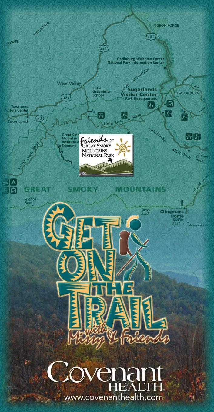
1 Covenant Health presents
2 Trail Guidelines Wear proper hiking shoes. Please be on time. Make sure that you understand & have signed the waiver. Do not hike alone! Hike in a group. Bring plenty of water and appropriate snacks for yourself. Enclosed you will find a list of the trail maps, please keep this with you during the hikes. If you are unable to attend the weekly hike, please notify the call center at so we can include individuals from the waiting list. Carry a small first aid kit on every hike. Staff members and the Emergency Medical Technicians will carry larger kits. Be aware of the weather. Covenant Health Passport Club will provide ponchos; carry it with you on all hikes. Be aware of bears! Remain watchful. If you see a bear at a distance do not approach it. Take nothing but pictures and leave nothing but footprints. 12. Enjoy! Dear Hikers, Covenant Health and Friends of the Smokies are excited about our upcoming Get on the Trail with Missy and Friends spring hiking series. We are so glad you have signed up to go on one or all five hikes. This series provides a fun way to improve your fitness while helping fund the many projects Friends of the Great Smoky Mountains National Park contributes to each year. Each series, you and our sponsors help raise more than $5,000 dollars for the GSMNP through this program. Hiking is the best way to experience our beautiful park, which is decorated by an abundance of spring wild flowers. However, it can be strenuous. So make sure you have been exercising 3-5 days a week prior to our hikes. A 5-mile hike is more like a 6 to 7 mile walk on flat roads. Review the checklist to make sure you are wearing the proper attire and don t forget to bring plenty of water and a lunch. We meet at 8:00-8:15 a.m. at various sites. This means that most people will need to leave home by 6:40-7 a.m. to avoid traffic. We want to ensure you that your safety is our number one priority. Please know that we have staffed every hike with an Emergency Medical Technician - Intravenous Therapy and two additional CPR certified staff members. We ask that you approach Get on Trails with safety and precaution. Before starting every hike, please read the guidelines and practice them with every hike. We appreciate your participation! Sincerely, Missy and Covenant Health Staff

3 Hike #1- April 2, 2008: Grotto Falls Distance: 3 miles Meeting Place: Sugarlands Visitor Center at 8:15 am Elevation Notes: Approximately a gain of 500 feet in elevation in 1.5 miles Access Trail: Trillium Gap The Trillium Gap Trail meanders through an old-growth hemlock forest and leads to Grotto falls, a 25-foot waterfall that you can walk behind and one of the most picturesque waterfalls in the Great Smoky Mountain National Park. The trail is wide and easy despite a few rocky spots. The trail crosses small steams and creeks along the way making for a cool, moist environment, one that ideal to spot the 60 different types of amphibian species that call the Great Smoky National Park their home.

4 Hike #2- April 9, 2008: Little Greenbrier Loop Distance: 5.8 miles Meeting Place: Metcalf Bottoms Picnic Area at 8:15 am Elevation Notes: Approximately a gain of 600 feet in elevation Access Trail: The hike will begin at Metcalf Bottoms and continue past the old school house up to Little Brier Gap Trail. Take a left and follow Little Greenbrier Trail to the road that leads back to Metcalf Bottoms Fun facts about Little Greenbrier School: Little Greenbrier School was built in This log structure was used to teach near by families for over 50 years as well as a church for Sunday meetings. Formal classes ended in Miss Elsie Burrell brought back the spirit of Little Greenbrier in 1969 at the age of 65. Miss Elsie taught children till the age of 95 about the Smoky Mountains.

5 Hike #3- April 16, 2008: Max Patch Distance: 3.5 mile loop or an 8-10 mile trek towards Lemon Gap Meeting Place: The Cracker Barrel in Newport at 8:15 am; Rocky Top Tours will transport us to Max Patch Elevation Notes: A maximum gain of a 1000 feet in elevation depending on route Access Trail: Max Patch Max Patch is a longtime favorite with AT thru-hikers and regional folks wanting to escape for a few sunny hours. The view from the summit is superb: at arm s length, the grassy earth falls away with 360 degree views just beyond; it seems a short stride would plummet you to the floor of the Tennessee Valley, onto the backbone of Bluff Mtn., or atop the steppingstone crest of Mt. Sterling. Roane Mtn and Mt Mitchell are also visible in the distance.

6 Hike #4- April 23, 2008: Grapeyard and Injun Creek Trail Distance: 6 or 7.5 loop Meeting Place: Greenbrier Picnic area at 8:15 am Elevation Notes: Approximately a feet gain in elevation Access Trail: Near Greenbrier Cove The Greenbrier area contains one of the park s largest concentrations of chimney falls and rock walls, which mark the sites of former homesteads. The Grapeyard Ridge Trail follows Rhododendron Creek over the south slope of Brushy Mountain to the Jim Bales Place at Roaring Fork. The trail passes the remains of Civian Conservaton Corps CCC, several Rayfield homesites, and the 1920s-era remains of a wrecked Nichols and Shepard self-propelled, steampowered engine (known as a traction engine). The wrecked engine rests in the bed of Injun Creek.

7 Hike #5- April 30, 2008: Gregory Bald Distance: 9-11 mile loop depending on trailhead Meeting Place: Cades Cove Camp Ground 8:15 am Elevation Notes: This tough trip gains 3,000 feet in elevation Access Trail: Gregory Ridge Trailhead or Gregory Bald Trailhead Gregory Bald is a high meadow that was used in the summer for cattle grazing by the Cades Cove farmers. Several trails go to Gregory Bald. This particular trail affords a steady four and a half mile climb to the bald through pine and hardwood forest. From Gregory bald there are magnificent views of Cades Cove as well as other surrounding landmarks.
8 Name: Emergency Contact: Emergency Phone: Allergies:
9
ABOUT THE PARKS NANTAHALA NATIONAL FOREST MOUNTAINS NATIONAL PARK CHEROKEE NATIONAL FOREST PISGAH NATIONAL FOREST GREAT SMOKY HIKING TRAILS
 ABOUT THE PARKS GREAT SMOKY MOUNTAINS NATIONAL PARK NANTAHALA NATIONAL FOREST CHEROKEE NATIONAL FOREST PISGAH NATIONAL FOREST GREAT SMOKY MOUNTAINS NATIONAL PARK Straddling the border between North Carolina
Blue Ridge Hiking Club Hike List July- September 2016
 Blue Ridge Hiking Club Hike List July- September 2016 Saturday, July 2, Elk Knob: 3.8 mile round trip with 900 ft. gain in elevation. Spectacular views at the summit. The trails are mostly moderate, but
ROAD SCHOLAR SPRING HIKING ADVENTURE Tentative Schedule April 8-13, 2018
 Sunday, April 8 ROAD SCHOLAR SPRING HIKING ADVENTURE Tentative Schedule April 8-13, 2018 PM 3:00-5:00 Arrival, registration and move in to the dorm. 6:00 Supper EVE 7:00 Welcome & Orientation, Sign Ups
GREAT SMOKY MOUNTAINS FAMILY CAMP!
 GREAT SMOKY MOUNTAINS FAMILY CAMP! July 10-15, 2017 SCHEDULE OF EVENTS Monday PM 3:00-5:00 EVE 5:45 WELCOME! Arrival, registration and move in to the dorm. Supper 6:45 Welcome & Orientation & Sign Up for
ROAD SCHOLAR SPRING HIKING ADVENTURE Tentative Schedule April 9-14, 2017
 ROAD SCHOLAR SPRING HIKING ADVENTURE Tentative Schedule April 9-14, 2017 Sunday, April 9 PM 3:00-5:00 Arrival, registration and move in to the dorm. 6:00 Supper EVE 7:15 Welcome & Orientation, Sign Ups
Asheville & WNC Hikes
 Asheville & WNC Hikes Amazingly, we have 3,000+ miles of free public hiking trails near Asheville, including 1,600 miles in the Pisgah and Nantahala National Forests, 850 miles in Great Smokey Mountains
Blue Ridge Hiking Club - First Quarter 2018 Hikes
 Blue Ridge Hiking Club - First Quarter 2018 Hikes Monday, Jan 1: Trout Lake to Manor House & Figure 8 Trail: Meet at Trout Lake parking lot, at 9:30. (1st exit left off Parkway just south of Cone Manor
Family Hiking Day on the Appalachian Trail
 Family Hiking Day on the Appalachian Trail September 30, 2017 Guided Hikes and Trail Celebrations In celebration of National Public Lands Day, September 30th is Family Hiking Day on the Appalachian Trail!
Little Grand Canyon near Pomona, Illinois
 Little Grand Canyon near Pomona, Illinois Below: View of the trail and the terrain created using the Map My Hike app Below: Summary of the hike created using the Map My Hike app Presented by: Jennifer
Hiking Las Vegas.com
 Hike: Mt. Wilson via First Creek Canyon route Trailhead: First Creek marked Distance: 10 miles up and back Elevation gain: 3,400 feet Elevation of Peak: 7,070 feet Time: 7 to 9 hours (up and back) Difficulty:
Peak to Peak MST Segment 1A
 1 Mountains-to-Sea Trail Last Updated 1/1/2017 Peak to Peak MST Segment 1A View from the Mountains-to-Sea Trail at Clingmans Dome Photo by Danny Bernstein CLINGMANS DOME TO WATERROCK KNOB ALTERNATE ROUTE
KSNH SPRING CONFERENCE GREAT SMOKY MOUNTAINS April 10-13, 2014
 KSNH SPRING CONFERENCE GREAT SMOKY MOUNTAINS April 10-13, 2014 ALL TRIPS LEAVE FROM THE QUALITY INN UNLESS OTHERWISE STATED All meals are on your own. Quality Inn full breakfast opens at 6 am daily. PLEASE
Kitimat. Pacific Inland Coast. Hiking Guide Kitimat, British Columbia, Canada
 Kitimat Pacific Inland Coast Hiking Guide Kitimat, British Columbia, Canada 2010-2011 Sites and Trails Emergency Call 911 Police - Fire - Medical 2 Welcome to Kitimat This information was produced to assist
Route #1) Mt. of the Holy Cross - North Ridge
 Mt. of the Holy Cross - North Ridge") Climbing 14ers can be very dangerous, please read the Mountaineering Safety Page and make sure you have a map+compass and can use them effectively, without the help of electronic devices. Route #1) Mt.
Climbing 14ers can be very dangerous, please read the Mountaineering Safety Page and make sure you have a map+compass and can use them effectively, without the help of electronic devices. Route #1) Mt.
Seven Ponds Nature Center's Great Wildflowers of the Great Smoky Mountains April 15-20, 2018
 Seven Ponds Nature Center's Great Wildflowers of the Great Smoky Mountains April 15-20, 2018 Introduction The Southern Appalachians contain some of our country's most impressive natural features. The area
HIKING IN THE CANADIAN ROCKIES
 HIKING IN THE CANADIAN ROCKIES Distance Time Elevation y MORAINE LAKE TRAILS THE ROCKPILE 0.8 km (0.5 mi) 20 min 30 m (98 ft) Located adjacent to the Lodge, the short interpretive trail up the Rock Pile
CIEC 9 PEAKS AWARD SUPPLEMENT POSSIBLE ROUTES FOR THE 9 PEAKS AWARD TRIP
 CIEC 9 PEAKS AWARD SUPPLEMENT POSSIBLE ROUTES FOR THE 9 PEAKS AWARD TRIP As you plan your trip, be aware of 3 regulations in this wilderness: 1. Camp only in designated campsites. 2. No campfires allowed.
Lava Mountain Trail Distance: Elevation Range: Trail Type: Difficulty: Season: Driving Distance: Driving Time: USGS Maps: Pros Cons
 Lava Mountain Trail Distance: 13.4 miles (including the side trip to North Star Lake) Elevation Range: 5900'-8330' Trail Type: singletrack Difficulty: moderate Season: late June-October Driving Distance:
Suggested Day Hikes. Mount Greylock State Reservation 3, 4 1, 2. Take a Hike! Things to remember:
 Suggested Day Hikes Mount Greylock State Reservation Take a Hike! This guide offers suggested day hike routes in two parts: 1) Year-round Hikes and 2) Seasonal Hikes (late-may to Nov.1). Use this guide
Cherokee Hiking Club Trail Blurb
 Cherokee National Forest Trail #164 Distance: 6.2 miles Elevation Change: 2280 feet High Point: 3692 feet (Waucheesi Mountain) Low Point: 1412 feet (Wildcat Creek) Trail Rating: Moderately Strenuous (NW
beach. Make the ford and follow the trail out to the junction with Red Creek Tr in an open grassy area.
 Description: This is a moderate to slightly strenuous 22.8 mile backpack (add 2.6 miles if you do the packless out and back to the Lion s Head) that will have you exploring nearly every thing that is The
Drive and Stop Routes
 Drive and Stop Routes Limantour Road 1 - easy and likely productive. From Bear Valley Visitor Center drive back out and turn left onto Bear Valley Rd. Turn left at Limantour Road (the first road). Drive
Fall 2017 Hiking Schedule All Hikes Depart From Pavilion Across From White Pine and Hemlock Lodges
 Pace Codes: Fall 2017 Hiking Schedule All Hikes Depart From Pavilion Across From White Pine and Hemlock Lodges Leisurely: Nature or historical walk; frequent stops for observation Moderate: Steady, 1 to
GIFFORD PINCHOT NATIONAL FOREST
 GIFFORD PINCHOT NATIONAL FOREST 9341 Wright Meadow 93 Spencer Meadow Spencer Butte 4247' 30 30A 19 24 80 31C Lewis River Lower Falls 5 Quartz Creek 90 Taidnapam Falls Upper Falls 31 Spencer Peak 3861'
BRR Leg 1 (3.9 miles, Easy)
") BRR Leg 1 (3.9 miles, Easy) Min 3901 Max 4919 Ascent +21 Descent -1031 0.0 Start (Grayson Highlands State Park Visitor Center) 3.9 Grayson Highlands State Park Office & Gate, on R (EZ 1) Leg Notes: Minimal
BRR Leg 1 (3.9 miles, Easy) Min 3901 Max 4919 Ascent +21 Descent -1031 0.0 Start (Grayson Highlands State Park Visitor Center) 3.9 Grayson Highlands State Park Office & Gate, on R (EZ 1) Leg Notes: Minimal
Section 7: Pick Up Where You Left Off! S-Tree Road over the Todd Road
 2018 TRACE NOTES Helpful information for your adventure on Section 7 of the Hiker Challenge. Start Point S-Tree Rd. End Point Intersection Todd Rd. / Hale Ridge Rd. WEATHER DECISION Weather Alert!!!! Potential
Hike at Pico Blanco Labor Day Weekend!
 Hike at Pico Blanco Labor Day Weekend! The Pico Blanco Hymn Here among the trees majestic Pleasures you will find On the trails of Pico Blanco With your friends and mine Trail the Eagle ever onward This
Visitor s Center 110 E. Meeting Street Morganton, NC
 5 unique trails worth checking out! Cross-Country skiing! No snakes! Don t sweat it! www.discoverburkecounty.com Visitor s Center 110 E. Meeting Street Morganton, NC Photo of Table Rock by Justin Costner
Driving Time: 3 hours (allow extra time for stops)
") Scenic Byways loop This journey takes visitors through the eastern edge of Mt. Rainier National Park and along two of Washington s most beloved scenic byways, the Chinook Byway and the White Pass Scenic
Scenic Byways loop This journey takes visitors through the eastern edge of Mt. Rainier National Park and along two of Washington s most beloved scenic byways, the Chinook Byway and the White Pass Scenic
Route #2) Mt. Massive - Southwest Slopes
 Mt. Massive - Southwest Slopes") Route #2) Mt. Massive - Southwest Slopes Difficulty: Class 2 Ski: Advanced, D6 / R2 / III Exposure: Summit Elevation: Trailhead Elevation: Elevation Gain: Round-trip Length: Trailhead: County Sheriff:
Route #2) Mt. Massive - Southwest Slopes Difficulty: Class 2 Ski: Advanced, D6 / R2 / III Exposure: Summit Elevation: Trailhead Elevation: Elevation Gain: Round-trip Length: Trailhead: County Sheriff:
BRR Leg 1 (4.0 miles, Easy)
") BRR Leg 1 (4.0 miles, Easy) Min 3881 Max 4948 Ascent +36 Descent -1027 0.0 Start (Grayson Highlands State Park Visitor Center) 4.0 Grayson Highlands State Park Office & Gate, on L (EZ 1) Leg Notes: Minimal
BRR Leg 1 (4.0 miles, Easy) Min 3881 Max 4948 Ascent +36 Descent -1027 0.0 Start (Grayson Highlands State Park Visitor Center) 4.0 Grayson Highlands State Park Office & Gate, on L (EZ 1) Leg Notes: Minimal
TENNESSEE MOUNTAIN LIVING
 NOVEMBER 2016 Featuring Jasper Highlands TNLand.com END of the YEAR December 26th to Land Sale December 31st See back cover for more info... TENNESSEE MOUNTAIN LIVING JASPER HIGHLANDS - TENNESSEE'S MOST
Friday October 3. Lower Javelina Trail - Level D. about 3 miles, less than 500. Hike Contact: Joel Tormoen
 Friday October 3 Lower Javelina Trail - Level D. about 3 miles, less than 500 Hike Contact: Joel Tormoen joeltormoen@gmail.com Depart WB trailhead 8:00 am - return before 11:00 am This quite easy hike
EVENT SALE - March 27th to April 2nd
 EVENT SALE - March 27th to April 2nd 888-777-5758 JasperHighlands.com LOCATION With all the conveniences of a large city just 25 minutes away in Chattanooga and the friendliness of a small southern town
 Hike date Exertion Destination/ Leader(s) Description and Contact info Rating Hike Name 7/8-12/10 S+ Extreme Pleinair Sandy Compton Contact info: 208-290-1281 or sandy@scotchmanpeak.org This hike is nearly
TREK THE ROCKIES ABOUT THE CHALLENGE TREK THE ROCKIES FOR HIGHLAND HOSPICE CANADA TREK DEMANDING
 TREK THE ROCKIES CANADA TREK DEMANDING ABOUT THE CHALLENGE The Canadian Rockies are justifiably world-famous for their magnificent scenery: the combination of impressive, jagged mountains, bright turquoise
Southwest Family Adventure. 7 Days
 Southwest Family Adventure 7 Days Southwest Family Adventure See three amazing National Parks Grand Canyon, Bryce, and Zion on this epic camping trip designed with families in mind. Every day offers magnificent
Outings List for March February 2019 Harvey Broome Group (HBG) Tennessee Chapter of the Sierra Club
 Tennessee Chapter of the Sierra Club") Outings List for March 2018 - February 2019 Harvey Broome Group (HBG) Tennessee Chapter of the Sierra Club Everyone is welcome! You do not have to be a member to participate in any Sierra Club event. For
Outings List for March 2018 - February 2019 Harvey Broome Group (HBG) Tennessee Chapter of the Sierra Club Everyone is welcome! You do not have to be a member to participate in any Sierra Club event. For
Trail Beginning Elevation: 7553 ft The Poison Creek Trailhead is located at the end of National Forest Road 646E (NF-646E).
.") West Mountain Trails Poison Creek Trail #134 Length: 2.9 miles (4.7 km) Difficulty Horseback: A good trail for the first time west mountain rider, some steep sections Hiking: Most Difficult USGS Maps:
West Mountain Trails Poison Creek Trail #134 Length: 2.9 miles (4.7 km) Difficulty Horseback: A good trail for the first time west mountain rider, some steep sections Hiking: Most Difficult USGS Maps:
Griffith Park Trail Run Trail Guide Click for
 The Griffith Park Trail Run by Hike- LosAngeles.com Griffith Park Trail Run Trail Guide Click for downloadable cell phone guide and map from EveryTrail. DISTANCE: 4.55 Miles ELEVATION: 1280' ELEVATION
The gorges of Mohican Park in Ohio create a hiker's paradise Sunday, May 22, 2011 By Bob Downing, Akron Beacon Journal
 Pittsburgh Post-Gazette The gorges of Mohican Park in Ohio create a hiker's paradise Sunday, May 22, 2011 By Bob Downing, Akron Beacon Journal Bob Downing Big Lyons Falls drops 80 feet into a shady U-shaped
Hiking Las Vegas.com
 Hike: Juniper Peak up and back Trailhead: Oak Creek Canyon marked Distance: 5.5 miles round trip Elevation gain: 2,200 feet Elevation peak: 6,109 feet Time: 4 to 5 hours - Up and back Difficulty: 3 Danger
Royal Gorge Far Out Trail to Le Point
 Royal Gorge Far Out Trail to Le Point Direction to trailhead: From East Ridge Campground: Drive west from Canon City on US 50 to County Road 3A, the entrance road to the Royal Gorge Park. Turn left onto
This Passport: Revised October 20, 2017, EAM # Discovering the Trails of Penfield, NY
 This Passport: Revised October 20, 2017, EAM #161922 Discovering the Trails of Penfield, NY The Town of Penfield is fortunate to have a wide variety of natural resources which make for many unique and
TROOP FIVE BOY SCOUTS OF AMERICA (
 TROOP FIVE BOY SCOUTS OF AMERICA (http://www.troop5.net) HISTORIC MOUNT WASHINGTON HIKE LOCATION: White Mountain National Forest, New Hampshire DATE: Friday - Monday, June 25-28 th, 2010. TIME: Be at the
Staunton River Trail to Hoover Camp and Fork Mtn. Relay Tower (Based on September 18, 2013 hike by Ron Singleton, Fredericksburg, Va.
 Staunton River Trail to Hoover Camp and Fork Mtn. Relay Tower (Based on September 18, 2013 hike by Ron Singleton, Fredericksburg, Va.) The President's Cabin (The "Brown" House) at Camp Hoover. Sign on
FEES: Date of hike: Saturday, September 12th, 7:15 am (DST) aka Rez Time. Local Native American tribal members are free
 aka Rez Time. Local Native American tribal members are free") Date of hike: Saturday, September 12th, 2015 @ 7:15 am (DST) aka Rez Time Transportation: Transportation will not be provided by the Diabetes Prevention Program. Participants must drive in their own vehicles.
Date of hike: Saturday, September 12th, 2015 @ 7:15 am (DST) aka Rez Time Transportation: Transportation will not be provided by the Diabetes Prevention Program. Participants must drive in their own vehicles.
AOTA ArtTrek Locations
 AOTA ArtTrek Locations ArtTrek is a summer-long Grand County, CO art adventure. Highlighted by snow-covered mountain vistas and rolling meadows threaded with sparkling streams and rivers, numerous sites
Choose your own Adventure
 Choose your own Adventure Mountain Discovery STREAM ECOLOGY- We will introduce you to the life of an aquatic eco-system of a mountain freestone stream. We will put on a pair of waders, set out into Hesse
Outings List for March February 2018 Harvey Broome Group (HBG) Tennessee Chapter of the Sierra Club
 Tennessee Chapter of the Sierra Club") Outings List for March 2017 - February 2018 Harvey Broome Group (HBG) Tennessee Chapter of the Sierra Club Everyone is welcome! You do not have to be a member to participate in any Sierra Club event. For
Outings List for March 2017 - February 2018 Harvey Broome Group (HBG) Tennessee Chapter of the Sierra Club Everyone is welcome! You do not have to be a member to participate in any Sierra Club event. For
in the St. Croix Valley
 in the Parks Your Guide to in the St. Croix Valley Our parks and trails are fun places to PowerUp! Explore the amazing, family-friendly parks and trails, right here in the St. Croix River Valley. Use this
Mindful Mountain Hiking Program
 Mindful Mountain Hiking Program Want to head for the hills? Join the Mindful Mountain Hiking Program for the summer and early autumn. Day hikes in Kananaskis Country and the Rockies are led by ACMG Day
Explore Montana s Glacier National Park!
 Explore Montana s Glacier National Park! Sat-Sat, July 13-20 or July 20-27, 2019 1 P a g e Trailbound Trips Explore. Dream. Discover. Discover: * Stunning hikes * Glacier-studded mountain peaks * Wildlife
FAQ s. Upon completion of your registration you will receive a series of s, including:
 FAQ s ALL TRIPS 1. How will I know that I ve registered? - You will get an email from The Georgia Conservancy confirming your registration. If not, have a look in your junk mail folder. 2. If registered
September 6-8, 2013 Latimer Reservation
 September 6-8, 2013 Latimer Reservation Middle Tennessee Council 3414 Hillsboro Pike Nashville, TN 37215 (615) 383-9724 www.mtcbsa.org Summit Coordinator Sherry McGugin (931) 284-7707 smcgugin@frontiernet.net
County Line trail - Miller Peak to Little Navaho
 County Line trail - Miller Peak to Little Navaho 7-17-2008 This hike features a portion of the County Line trail in the Teanaway that receives extremely little use despite offering a spectacular ridge-run
Beaver Country Trails ATV Jamboree
 Beaver Country Trails ATV Jamboree #1 Lincoln Mine Intermediate (Open to all ATVs/UTVs) 34 Miles Highlights: This ride will highlight the historic Lincoln Mining District, the first lead mine in Utah,
Oregon Equestrian Trails Mt. Hood Chapter
 Oregon Equestrian Trails Mt. Hood Chapter November 17, 2010 To: Michelle Lombardo, Mt. Hood National Forest From: Barb Adams, Oregon Equestrian Trail, Mt. Hood Chapter Re: Barlow and Hood River Ranger
Photo Credit: Banff Lake Louise Tourism / Paul Zizka Photography MOUNTAIN ADVENTURES
 Photo Credit: Banff Lake Louise Tourism / Paul Zizka Photography MOUNTAIN ADVENTURES MOUNTAIN ADVENTURE PROGRAM Operated by Fairmont Chateau Lake Louise Fairmont Chateau Lake Louise has a long and proud
This Passport: Revised October 20, 2017, EAM # Discovering the Trails of Webster, NY
 This Passport: Revised October 20, 2017, EAM #161923 Discovering the Trails of Webster, NY The Town of Webster invites you to explore and experience our diverse outdoor adventures! Here s your opportunity
Piestewa Peak/Dreamy Draw Trail Guide
 Piestewa Peak/Dreamy Draw Trail Guide Trail #1A - Perl Charles Memorial Trail Length: 4.8 miles Elevation: 2,200 ft. - 1,340 ft. Difficulty: Moderate to difficult The Perl Charles trailhead is located
Mindful Mountain Hiking Program
 Mindful Mountain Hiking Program Want to head for the hills? Join the Mindful Mountain Hiking Program for the summer and early autumn. Day hikes in Kananaskis Country and the Rockies are led by ACMG Day
Climbing Oak and Brushy Top Mountains
 Climbing Oak and Brushy Top Mountains Story and photographs by Vann Helms www.blueridgeimpressions.org Brushy Top Mountain- February 2, 2014 Brushy top summit After a January of record breaking cold weather,
Trail Details Location
 Blind Blue Ribbon Centennial Conditions: Forest trail, with duckboards, and rope railing. Need: Blind trail activity bag, available in the camp office. None Availability: Open all seasons. Use the outdoor
San Luis Obispo. Bishop Peak Felsman Loop Eagle Rock Maino Open Space Poly Canyon Poly P Other Areas
 San Luis Obispo Bishop Peak Felsman Loop Eagle Rock Maino Open Space Poly Canyon Poly P Other Areas 1 JCT. ELEV. 72 400 00 0 FELSMAN LOOP GATE LOOP RIDGE 600 FENCE JCT. ELEV. 860 1000 1200 BISHOP PEAK
Road and Trail Report 04/02/2015
 U.S.D.A. FOREST SERVICE KETCHUM RANGER DISTRICT 206 SUN VALLEY ROAD P.O. BOX 2356 KETCHUM, ID 83340 (208) 622-5371 Road and Trail Report 04/02/2015 o Dry weather and a dwindling snowpack continue to bring
C E N T R A L C A T S K I L L S
 120 C E N T R A L C A T S K I L L S Central Catskills Once out of the southern parts of the Catskills, the Long Path enters the more well traveled and civilized regions. The trail joins the Devil s Path,
Hiking in Connestee Falls
 Hiking in Connestee Falls Connestee Falls Property Owners Association, Inc. 33 Connestee Trail, Brevard, NC 28712 828-885-2001, email cfpoa@citcom.net www.connesteefalls.com 1 Few private communities,
DOWNLOAD OR READ : WILDFLOWERS OF THE SMOKIES PDF EBOOK EPUB MOBI
 DOWNLOAD OR READ : WILDFLOWERS OF THE SMOKIES PDF EBOOK EPUB MOBI Page 1 Page 2 wildflowers of the smokies wildflowers of the smokies pdf wildflowers of the smokies [PDF] Amazonia in the Anthropocene:
Top Trails: Great Smoky Mountains National Park: 50 Must-Do Hikes For Everyone By Johnny Molloy
 Top Trails: Great Smoky Mountains National Park: 50 Must-Do Hikes For Everyone By Johnny Molloy Slide 43 of 51: Located in the Great Smoky Mountains, the Located in the heart of Rocky Mountain National
Whiteside Mountain Land Owned by: Location: Trails:
 Whiteside Mountain Latitude: 35 05.123 N Longitude: 083 07.933 W Elevation: 1,503m Land Owned by: US Forest Service Nantahala Ranger District 828-524-6441 Location: Jackson County, NC Turn off of US Highway
A North Carlina Pet Getaway in Lake Lure and the Blue Ridge Foothills
 A North Carlina Pet Getaway in Lake Lure and the Blue Ridge Foothills Explore our quaint downtowns and enjoy the friendly faces and wagging tails that will welcome you to Lake Lure and the Blue Ridge Foothills.
Hiking/ Trekking. Vocabulary. Kontakt
 Hiking/ Trekking Vocabulary altitude sickness - an illness caused from being at high elevations a canteen - a container used for carrying drinking water dehydration - a physical condition caused by not
Adventures in the Rockies. 6 Days
 Adventures in the Rockies 6 Days Adventures in the Rockies On this action-filled adventure, experience two different sides to the Rockies on the western side, discover hidden gems that few visitors get
playwinterpark.com Off The Beaten Path Hikes Hiking Recommendations for the Adventurous Hiker
 playwinterpark.com Off The Beaten Path Hikes Hiking Recommendations for the Adventurous Hiker Hike: Devil s Thumb (difficult) Length: 3.93 miles one-way Elevation: Trailhead 9609 Destination 12,236 Trailhead
Three Sisters Wilderness Oct. 2009
 Three Sisters Wilderness Oct. 2009 I was in Bend, OR and had the whole day to travel back to Boise so I decided to take a hike to the popular Green Lakes and summit the South Sister in Three Sisters Wilderness.
ALL STUDENTS MUST HAVE THEIR EQUIPMENT CHECKED AT ONE OF THESE TWO TIMES IN ORDER TO PARTICIPATE IN THE TRIP.
 May, 2014 Dear Rising Sophomores and Parents, We are happy to share with you the details of the 2014 Sophomore Backpacking Trip, scheduled for Wednesday, September 3 through Saturday, September 6, 2014.
TAHOE GETAWAY. Monday, October 1 through October 4, 2012
 TAHOE GETAWAY Monday, October 1 through October 4, 2012 COORDINATORS Sue Geisler --- Hiking Dennis Ratay --- Lodging Lodging is now filled. Waiting List: Anyone else interested in participating in the
UNF Wildlife Sanctuary. Eco Camp 2017
 UNF Wildlife Sanctuary (904) 620-5952 rectrail@unf.edu 1 UNF Drive Building 54 Jacksonville, Fl 32224 Eco Camp 2017 Parent Packet and Information Hello Eco Campers and Parents! You are about to experience
Allegheny Trail to Pine Swamp
 16.5 miles, Strenuous, $5.00 carpool fee 62 miles from Roanoke Allegheny Trail to Pine Swamp The hike will start in Monroe County, West Virginia. It begins on WV CR15 at the parking lot for the Hanging
Great Smoky Mountains National Park Summer Ranger Programs June 17-Aug 11, 2018
 Great Smoky Mountains National Park Summer Ranger Programs June 17-Aug 11, 2018 Sundays: Coffee With a Ranger 10:00 a.m. Join a Ranger for a cup of coffee and find out what s happening in the park! Coffee
Glacier National Park
 Glacier National Park West Glacier, MO Page 1 Page 3-6 Report Rough Draft Glacier National Park Glacier National Park is located in the northwest corner of Montana and extends into Canada. It is located
Bradshaw Trails Series
 Bradshaw Trails Series Curtis James Troop 7014 Curtis.James@erau.edu My Motto: Never get lost! Hiking Rules Bradshaw Hiking Patch Series Hiking Tools Hiking Rules Hiking Merit Badge* Take five 10-mile
HORSEBACK RIDING. All rates are subject to service charges
 HORSEBACK RIDING The Local Loop Ride - A family-friendly 45-minutes to one hour ride around Dunton s east property. Perfect for children and adults who are new to riding. Easy terrain and beautiful views.
Your Guide to Mountainbiking around Atlin (yes, you can hike these trails as well)
") Your Guide to Mountainbiking around Atlin (yes, you can hike these trails as well) Foreword Thanks to the rich mining history in Atlin, the historic mining roads have become the perfect trails for recreational
Your Guide to Mountainbiking around Atlin (yes, you can hike these trails as well) Foreword Thanks to the rich mining history in Atlin, the historic mining roads have become the perfect trails for recreational
DAY 1 Ten miles out of Detroit, we cut off onto Whitewater Road 2243, a bumpy, gravel road that ends in a parking lot at the Whitewater Trailhead.
 1 WILDERNESS TREK VIII August 14-18, 2014 Greg and I chose to return to JEFFERSON PARK, a pristine, lake-filled, high mountain meadow on the North side of Oregon's own beautiful, Mt. Jefferson. In preparing
GOLDEN EARS PROVINCIAL PARK
 GOLDEN EARS PROVINCIAL PARK Trail Information as of October 10 th 2015 Do not underestimate the mountainous wilderness of Golden Ears Provincial Park. The combination of rugged terrain and rapidly changing
CWH Posting Your Own Hikes
 Posting Your Own Hikes and Making Changes to these Hike Listings POSTING YOUR OWN HIKES Welcome to Posting Your Own Hikes on the Calgary Weekenders Hikers website. This document will walk you through posting
Sample Klondike Information (This information is just generic Klondike information)
") Sample Klondike Information (This information is just generic Klondike information) Sled Check-in and Inspection Procedures Each patrol will begin the day by registering their sled between the hours of
Sample Klondike Information (This information is just generic Klondike information) Sled Check-in and Inspection Procedures Each patrol will begin the day by registering their sled between the hours of
Mini cruise Calvi, St-Tropez
 Mini cruise Calvi, St-Tropez EUROPE & MEDITERRANEAN COASTS / NICE TO NICE 5 DAYS /4 NIGHTS EXTEND YOUR STAY IN A CLUB MED RESORT: CRUISE ON THE CLUB MED 2 Welcome aboard Club Med 2, for a unique experience
Pocahontas Area Map Jasper INFORMATION CENTRES Lake Louise Field Golden Banff
 Pocahontas Miette Hot Springs Area Map Jasper Maligne JASPER Columbia Icefield Saskatchewan River Crossing INFORMATION CENTRES Banff National Park Louise Kootenay Park Lodge Yoho National Park Columbia
Leg 1 (4.0 miles, Easy)
") Leg 1 (4.0 miles, Easy) Leg Description: Steady, but controlled downhill (paved). Leg Notes: Great views of the Grayson Highlands balds and mountains. Watch for wild ponies. 0.0 Grayson Highlands State
Leg 1 (4.0 miles, Easy) Leg Description: Steady, but controlled downhill (paved). Leg Notes: Great views of the Grayson Highlands balds and mountains. Watch for wild ponies. 0.0 Grayson Highlands State
Salmo Ski Hill 2015 Operating Season SVTS Annual Work Plan
 Salmo Ski Hill 2015 Operating Season SVTS Annual Work Plan 2014 Review Our goal for 2014 had been to complete construction of a 2.5km loop trail (Figure 1) with scouting and possibly layout for the remainder
Best Hikes on Orcas Island
 Published on San Juan Islands Washington Visitors Bureau Orcas Island Lopez Island Friday Harbor San Juan Island (https://www.visitsanjuans.com) Best Hikes on Orcas Island The Emerald Isle offers big trees,
Gatlinburg Pigeon Forge Smoky Mountains. Restful Retreat Hurley Dr. #402, Sevierville, TN US
 Gatlinburg Pigeon Forge Smoky Mountains 1410 Hurley Dr. #402, Sevierville, TN 37862 US 1-800-371-0341 Reservations@SmokyMtnDreams.com Welcome Welcome to in the Smoky Mountains! This absolutely beautiful
CMC Member Guide to the CMC Website
 CMC Member Guide to the CMC Website HOW TO: Sign Up or Cancel a Trip/Event/Class Change Your Personal Information PLUS HOW TO FIND: Renew Your Membership Trip classification information Denver Group Classification
Grizzly Peak A - East Ridge July 15, 2012
 Grizzly Peak A - East Ridge July 15, 2012 Difficulty: Difficult Class 2/Class 3 Upper Elevation: 13,995 feet Trailhead Elevation: 11,360 feet Elevation Gain: 3,000 feet Round-trip Length: 6.0 miles Trailhead:
(west) onto Charleston Boulevard. Drive 16 miles on Charleston and turn right into Red Rock
 onto Charleston Boulevard. Drive 16 miles on Charleston and turn right into Red Rock") Hike: North Peak and Ice Box Overlook up and back Trailhead: 2.5 miles up the Rocky Gap Road not mark Distance: 5 miles round trip Elevation gain: 2,694 feet Elevation Peak: 7,094 feet Time: 3 to 5 hours
Hike: North Peak and Ice Box Overlook up and back Trailhead: 2.5 miles up the Rocky Gap Road not mark Distance: 5 miles round trip Elevation gain: 2,694 feet Elevation Peak: 7,094 feet Time: 3 to 5 hours
Yellowstone & Grand Teton: Walking America s First National Park
 Yellowstone & Grand Teton: Walking America s First National Park Yellowstone & Grand Teton: Walking America s First National Park A massive canyon carved by an ancient volcano plumes of water leaping into
LOST ON THE APPALACHIAN TRAIL
 page 1 / 5 page 2 / 5 lost on the appalachian pdf Cove forest is the name for a type of deciduous forest community associated with Appalachian mountain coves. Cove forests, which are unique to the Appalachian