Death Valley National Park Wilderness and Backcountry Stewardship Plan and Environmental Assessment
|
|
|
- Derick Houston
- 6 years ago
- Views:
Transcription


1 National Park Service United States Department of the Interior Death Valley National Park California and Nevada Death Valley National Park Wilderness and Backcountry Stewardship Plan and Environmental Assessment August 2012
2 ON THE COVER July Bloom on Panamint Mountains near Sentinel Peak, 2009 Photographer: Emily McCuistion, Death Valley National Park Archeology Team

3 WILDERNESS AND BACKCOUNTRY STEWARDSHIP PLAN AND ENVIRONMENTAL ASSESSMENT National Park Service Death Valley National Park California and Nevada
4
5 Death Valley National Park Wilderness and Backcountry Stewardship Plan/Environmental Assessment Inyo and San Bernardino Counties, California Nye and Esmeralda Counties, Nevada The original protected area of Death Valley National Monument was designated by Presidential Proclamation on February 17, The 1994 California Desert Protection Act (P.L ) enlarged the park to its present size and designated 91% of the park as the Death Valley National Park Wilderness totaling 3,102,456 acres. Another 220,000 acres of the park are undeveloped backcountry lands and a network of over 1000 miles of pre-existing backcountry dirt road corridors that serve as both a visitor experience in themselves and access to the expansive wilderness and backcountry. The scope of this Wilderness and Backcountry Stewardship Plan addresses all congressionally designated wilderness lands within Death Valley National Park. It also includes non-wilderness backcountry concerns, such as: backcountry road corridors and campsites, backcountry cabins near roads, and non-wilderness backcountry lands. This plan is considered an implementation plan tiered from the 2002 Death Valley National Park General Management Plan and its associated Environmental Impact Statement. This Wilderness and Backcountry Stewardship Plan includes an environmental assessment as the environmental impact analysis document required under the National Environmental Policy Act. Cooperating agencies (as defined by the National Environmental Policy Act) in the preparation of this plan include Inyo County (CA), Nye County (NV), and Esmeralda County (NV). The Timbisha Shoshone were also substantially involved throughout the planning process. This plan presents and analyzes four alternatives to provide future direction for the stewardship, administration, and visitor use of these vast lands. The potential environmental impacts of all alternatives have been identified and assessed. Alternative A: No-action Alternative would continue existing management practices which tend to be reactive to the needs of the moment rather than being proactive toward specific goals. Alternative B: Minimum Action Alternative would maximize outstanding opportunities for solitude or primitive and unconfined recreation by largely formalizing the no-action alternative and adding a few specific actions to address current visitor impacts issues while fulfilling agency requirements for wilderness and backcountry administration. Alternative C: Maximum Action Alternative would provide more opportunities for park visitors with less experience or lacking specialized equipment and proposes the greatest increase in new visitor facilities and administrative requirements with the intent of proactively addressing future visitor impacts. Alternative D: Focused Action Alternative, which is the agency s preferred alternative, would recognize and protect the premier wilderness and backcountry resource values of the entire park while providing for a wider range of visitor experiences and opportunities in specific locations primarily along maintained road corridors. It also proposes a moderate increase in new visitor facilities and administrative requirements with the intent of addressing known visitor impacts and those anticipated in the near future. This Wilderness and Backcountry Stewardship Plan and Environmental Assessment has been distributed to other agencies and interested organizations and individuals for their review and comment. The public comment period for this document will last for 60 days. Readers are encouraged to submit comments on this plan at You may also send written comments to Superintendent, Death Valley National Park, Attn: Wilderness Plan Comments, P.O. Box 579, Death Valley, CA See How to Comment on this Plan, immediately following, for further information. i
6 How to Comment on this Plan Comments on this Wilderness and Backcountry Stewardship Plan are welcome and will be accepted for 60 days after its release. If you wish to comment on the environmental assessment, please visit the NPS website below, or you may mail or comments to the address below. Our practice is to make all public comments available for public review. Individual respondents may request that we withhold their name and/or home address from the record, which we will honor to the extent allowable by law. If you want us to withhold your name and/or address, you must state this prominently at the beginning of your comment or select that information on the webform. We will make all submissions from organizations and businesses, and from individuals identifying themselves as representatives or officials of organizations or businesses, available for public inspection in their entirety. Comment online at the NPS Planning, Environment, and Public Comment Website: By Or by hardcopy to: Superintendent, Death Valley National Park Attn: Wilderness Plan Comments P.O. Box 579 Death Valley, CA ii
7 Executive Summary This Wilderness and Backcountry Stewardship Plan (the Plan) and Environmental Assessment provide direction for the National Park Service to make decisions regarding the future use and protection of the park s vast wilderness and backcountry lands. This planning process addresses all Congressionally designated wilderness and potential wilderness lands within Death Valley National Park as designated by the California Desert Protection Act of It also includes non-wilderness backcountry concerns including backcountry road corridors and campsites, backcountry cabins near roads, and non-wilderness backcountry lands. This plan was developed in consultation with the Timbisha Shoshone Tribe and these cooperating agencies: Inyo County (CA), Esmeralda County (NV), and Nye County (NV). The purpose of this Wilderness and Backcountry Stewardship Plan and Environmental Assessment for Death Valley National Park is to provide a framework by which to preserve and improve wilderness character while providing for unique visitor opportunities for quiet, solitude, and primitive adventure; and to accommodate continued use of the Park s unpaved roads and protection of backcountry resources. Completion of the planning process and approval of the plan also fulfills the requirements of NPS policy that parks have a wilderness management plan and a backcountry management plan (combined in this case) and addresses the needs identified in the 2002 General Management Plan. This purpose will be achieved through advancement of the following goals: common to both wilderness and backcountry: promote safety and outdoor ethics; preserve natural and cultural resources; preserve dark night skies; preserve natural soundscapes; minimize conflicts between user groups as well as between users and sensitive resources; accommodate and manage commercial uses as subject to applicable laws and policies; preserve undisturbed areas for appropriate scientific research; and proactively foster an inspired and informed public and park staff who value the preservation of the Park s natural and cultural resources. specific to wilderness: preserve the untrammeled quality of wilderness character by refraining from the deliberate manipulation or management of wilderness resources except as necessary to promote another quality of wilderness character or to preserve human life or to accommodate other activities in compliance with applicable laws; promote the natural quality of wilderness character through the thoughtful restoration and/or maintenance of natural processes and features while managing archaeological, historical and ethnographic sites in a manner that is compatible with wilderness and cultural resources management laws; preserve and enhance the undeveloped quality of wilderness character by judicious review and, where appropriate, removal of non-conforming and/or unnecessary installations; provide for outstanding opportunities for solitude or primitive and unconfined recreation as long as such visitor uses can be offered without degradation of significant natural and cultural resource values; preserve ecological, geological, scientific, educational, scenic, and historical values of wilderness, including culturally significant resources and paleontological resources within wilderness as important and prominent values of the Death Valley NP Wilderness consistent with the California Desert Protection Act and the General Management Plan; iii
8 preserve the intangible aspects of wilderness, including the ethnographic value to the Timbisha Shoshone and accommodate ongoing traditional cultural uses by the Timbisha Shoshone within their Natural and Cultural Preservation Area and other special use areas. specific to non-wilderness backcountry: allow for continued use of backcountry roads where appropriate for multiple purposes, including: o to accommodate recreational access; o to accommodate administrative access and other authorized uses; o to accommodate opportunities for recreational backcountry road travel (including vehicles, bicycle, stock, foot, etc); o to facilitate voluntary stewardship of backcountry roads and cabins by interested publics; o to provide for continued roadside camping opportunities; o to provide for campfires where safe and appropriate; o and as a gateway to wilderness. accommodate continued backcountry cabin use while providing for the protection of historic resources and public health and safety. minimize impacts of backcountry uses on adjacent wilderness lands. This environmental assessment has been prepared in accordance with the National Environmental Policy Act of 1969, as amended; the regulations of the Council on Environmental Quality (40 Code of Federal Regulations ); NPS Director s Order 12: Conservation Planning, Environmental Impact Analysis, and Decision making; the National Historic Preservation Act of 1966, as amended; and the Endangered Species Act of 1973, as amended. The environmental assessment analyzes the environmental impacts of four alternatives: No-action (Alternative A): This alternative would continue existing management practices, resulting in current resource conditions and visitor opportunities, and the logical progression of probable trends over time. It is required as a baseline against which the other alternatives can be compared. Without the guidance of a Wilderness and Backcountry Stewardship Plan, there would not be a clear focus for setting priorities for management actions or visitor use. Management would continue to tend to be reactive to the needs of the moment rather than being proactive toward specific goals. Minimum Action (Alternative B): To fulfill the intent of maximizing outstanding opportunities for solitude or primitive and unconfined recreation, visitor services and park operations would be conducted in a manner that minimizes the imprint of modern humans within the wilderness. There would be no new or very limited new infrastructure and facilities in the backcountry. Resource and visitor experience conditions that are currently unacceptable or that are approaching unacceptable would be identified and addressed through targeted management actions using the least intensive management tools suitable to the situation. This alternative largely formalizes the no-action alternative and adds a few specific actions to address current visitor impact issues while fulfilling current agency requirements for wilderness and backcountry administration (e.g. adopting a minimum requirements decision process, evaluating science in wilderness, etc.). Maximum Action (Alternative C): Outstanding opportunities for solitude or primitive and unconfined recreation would still occur for self-reliant visitors, but there would be more opportunities for park visitors with less experience or lacking specialized equipment. The park would seek opportunities to partner with neighboring land management agencies to provide improved access between the park and adjacent public lands. Where appropriate, new infrastructure and facilities would be developed in backcountry locations to enhance visitor opportunities and mitigate visitor use impacts. Visitor services and park management operations, including field activities, education, outreach, and interpretive programs would likely increase from current levels. Highest priority would be given to addressing locations where impacts of visitor use are iv
9 currently unacceptable and actions would be taken to manage visitor use or specific aspects of visitor use in order to meet standards. Over time, other locations would receive increased management with the intent of proactively managing visitor use to maintain desired visitor experiences and protect park resources. All agency requirements for the administration of wilderness and backcountry lands and operations are addressed. Focused Action (Alternative D, NPS Preferred Alternative): This wilderness and backcountry stewardship alternative would recognize and protect the premier wilderness and backcountry resource values of the entire park while providing for a wider range of visitor experiences and opportunities in specific locations. Some areas along paved and unpaved maintained road corridors would be managed for those visitors who want to experience the wilderness and backcountry but may need additional services, facilities, and/or direction or who may lack the specialized equipment (e.g. high ground clearance 4-wheel-drive vehicles) to access other areas of the park. The majority of the wilderness, backcountry, and backcountry roads would be managed for self-directed exploration as well as self-reliant travel. Currently unacceptable visitor impacts and those impacts anticipated to manifest in the near future are proactively addressed through specific visitor use actions, including facilities and administrative tools. All agency requirements for the administration of wilderness and backcountry lands and operations are addressed. Each action alternative (alternatives B, C, and D) include geographic allocation between four zones: wild, backcountry exploration, backcountry corridor, and high use/directed use. Specific locations zoned as high use/directed use are addressed in detail regarding visitor issues, measures, standards, and proposed management actions. In addition to zoning and the management direction inherent to each zone, each alternative also includes specific details regarding wilderness use (group size limits, human waste disposal, visitor use restrictions, and carrying capacity limits), commercial services and special park uses (permitted activities, locations, and limits), backcountry facilities(roads, campgrounds, designated roadside camping corridors, dispersed roadside camping, trails and trailheads, cabins, campfire rings, and signs), administrative activities (overnight visitor use permits and administrative camps), and costs (one time expenditures and annual operating expenses). Some management actions were also identified to be applicable to all alternatives except the no-action alternative, including type and locations for stock use, facilitation of volunteer stewardship activities, adoption of procedures for administration of commercial services and special park uses, adoption of a visitor education strategy that incorporates Leave No Trace and Tread Lightly!, administration of scientific activities in wilderness, resource management activities focused on restoring natural conditions including restoration of sheetflow at Racetrack Playa, and actions to manage specialized recreation in wilderness including the adoption of a process to evaluate emerging recreational uses. Attribute Alternative A: No Action Alternative B: Minimum Action Alternative C: Maximum Action Alternative D: Focused Action Total Miles of Backcountry 1,000 miles 1,000 miles 1,000 miles 1,000 miles Roads Total acres of designated 3,100,000 acres 3,100,000 acres 3,100,000 acres 3,100,000 acres wilderness Total acres of planning area 3,320,000 acres 3,320,000 acres 3,320,000 acres 3,320,000 acres (wilderness and backcountry) Acres in High Use/Directed Not applicable 8,000 acres 27,000 acres 17,000 acres Use Zone Acres in Backcountry No applicable 8,000 acres 18,500 acres 6,000 acres Corridor Zone Acres in Backcountry Not applicable 205,000 acres 181,000 acres 202,500 acres Exploration Zone Acres in Wild Zone Not applicable 3,099,000 acres 3,093,500 acres 3,094,500 acres Miles of maintained roads 300 miles 300 miles 580 miles 410 miles Miles of non-maintained roads 700 miles 700 miles 420 miles 590 miles v
10 Miles of designated roadside camping corridors Miles of backcountry roadside open to dispersed camping Not applicable 0 70 miles 55 miles 770 miles 770 miles 665 miles 695 miles The following impacts topics were analyzed in detail for each of the four alternatives and the conclusions are summarized below: Wilderness Character Impacts to wilderness character as a result of implementing alternative A or B would likely be negligible or minor. Some sources of degradation, largely outside of NPS control (such as air, light, and noise pollution) would continue to persist but are not likely to be acute enough to be observed by most visitors. Some opportunities to improve wilderness character would likely not be realized. Impacts to wilderness character as a result of implementing the maximum action alternative (alternative C) and focused action alternative (alternative D) would likely be moderate, both with some beneficial and some adverse impacts. Both alternatives would realize improvements to the untrammeled, natural, undeveloped, and outstanding opportunities for solitude or primitive and unconfined recreation. However, some degradations would continue to persist and some new, localized degradations to viewshed and unconfined recreation would be realized through the development of some minor visitor facilities on backcountry lands near wilderness. Generally, impacts associated with the untrammeled quality tend to be short-term while the impacts (positive or negative) associated with the other qualities tend to be long-term. Wildlife Vegetation The focused action alternative (alternative D) would produce minor long-term beneficial impacts to wildlife by managing human waste and delineating trails around high use riparian areas, as well as by implementing a Backcountry and Wilderness Education Strategy and by systematically removing fences and other debris that threatens wildlife health. There would be negligible to minor long-term beneficial impacts to wildlife from delineating campsites and roadside camping corridors, and defining group size limits. The adverse impacts to wildlife from maintaining an additional 110 miles of existing backcountry roads would be minor and long term. The maximum action alternative (alternative C) would produce principally the same beneficial impact levels, with more adverse impacts to wildlife from the additional 280 miles of backcountry road maintenance on existing roads. The minimum action alternative (alternative B) would have smaller commercial and private group sizes, producing more benefits to wildlife from these constraints, but would not address trail delineation or designated campsites, with negligible to minor adverse effects. No additional road maintenance under this alternative would reduce vehicle-related mortality. The no-action alternative (alternative A) would similarly have no additional road maintenance, but it would also not address human waste concerns, visitor education, hazard debris removal, trail delineation, or campsites, resulting in an overall minor adverse impact to wildlife. Each of the action alternatives (alternatives B, C, and D) for this plan would result in both adverse and beneficial long-term impacts to vegetation. Establishing trails and trailheads would eliminate social trail formation and protect vegetation, as would establishing restroom facilities in high use areas. These management actions vi
11 would result in minor beneficial impacts to vegetation communities in localized areas, and the degree of benefit would vary by alternative according to the facilities proposed under each alternative. The proposal for additional road grading and subsequent visitor use along those improved road corridors in the maximum action alternative (alternative C) and the focused action alternative (alternative D) would result in an increase in the spread of exotic vegetation, which would be a moderate long-term adverse impact of these alternatives that would require additional monitoring and weed control along improved road corridors in order to mitigate impacts to minor. The focused action alternative (alternative D) would present significantly less area to mitigate for than the maximum action alternative (alternative C). Special Status Species The focused action alternative (alternative D) would result in a negligible to minor beneficial long-term impact to the desert tortoise because of a provision under this alternative for a designated roadside camping corridor in the Greenwater Valley with accompanying surveys to avoid tortoise in selecting site locations, restoration of tortoise habitat in previously used dispersed sites, and the installation of signage to prevent inadvertent vehicular impacts to tortoise. In addition, implementing the Backcountry and Wilderness Education Strategy under this alternative would provide a minor beneficial impact to the species and its habitat park-wide. Delineation of trails in riparian areas under the focused action alternative would cut down on social trail formation and would likely produce a negligible to minor beneficial impact on special status bird species that are dependent on riparian habitat. The determination of effect for all special status wildlife species under this alternative would be no effect. Implementing the maximum action alternative (alternative C) would provide similar beneficial impacts to special status wildlife species. The minimum action alternative (alternative B) would result in less protection for the desert tortoise in Greenwater Valley, and less protection for riparian bird species along the Cottonwood-Marble Loop, resulting in negligible to minor adverse impacts to special status animal species. The no-action alternative (alternative A) would provide no Education Strategy and result in no management action to protect special status wildlife species, and the impact to these species would be long-term, minor, and adverse. The focused action alternative (alternative D) would have minor, long-term beneficial impacts to the Eureka Dunes Evening Primrose and Eureka dunegrass, resulting from additional delineated campsites, a group campground, recruitment of a camp host, and restrictions on sandboarding. Overall, the determination of effect for federally listed plant species under this alternative would be no effect. Rare but not federally listed plants such as the shining milkvetch and Death Valley sandpaper plant would see minor, long-term benefits under all action alternatives (alternatives B, C, and D) from the sandboarding prohibition on the Ibex and Panamint Dunes. The maximum action alternative (alternative C) would provide the same level of beneficial impacts as the focused action alternative (alternative D), while the minimum action alternative (alternative B) would have slightly less benefit to federally listed species because it would not include delineation of four additional campsites to minimize resource conflicts. The no-action alternative (alternative A) would have long term, moderate adverse impacts to federally listed and rare plant species. vii
12 Geologic, Soil, & Paleontological Resources With regard to geologic resources, all of the action alternatives (alternatives B, C, and D) would be preferred over the no-action alternative (alternative A). This is because the action alternatives include restoring playa-forming processes and preventing vehicle trespass on the Racetrack. This is expected to have moderate beneficial impacts to this noteworthy geologic and scientific resource. Also, a framework for evaluating impacts from research activities (including collection limitations) would be developed under all of the action alternatives. This is likely to result in a minor positive impact on geologic resources compared to the no-action alternative. All of the action alternatives present different levels of facilities construction or improvement that would have proportionate impacts to soils. With regard to facilities construction or improvement, the minimum action alternative (alternative B) presents the lowest level, the maximum action alternative (alternative C) presents the highest level, and the focused action alternative (alternative D) presents an intermediate level. Higher levels of facilities construction or improvement would increase backcountry accessibility, and therefore likely increase backcountry visitation. Higher visitation rates present the possibility of higher levels of adverse impacts to soils. However, the facilities construction improvements may counteract the impacts from increased visitation by preventing contamination from human waste, and restricting camping and parking sprawl. The action alternatives also present different levels of restrictions on activities and events, and the potential for soil impacts increase with increasing group sizes, activities, and events. With regard to the limitations on group sizes, activities, and events; the minimum action alternative (alternative A) is the most restrictive; the maximum action alternative (alternative C) is the least restrictive; and the focused alternative (alternative D) is intermediately restrictive. All of the action alternatives have negligible to minor adverse and beneficial impacts to geology and soils from the various balances of accessibility, facilities, and regulation. Impacts to paleontological resources will remain unchanged as a result of any of the plan s alternatives, and are expected to be moderate, beneficial, and long term resulting from the protection of the Copper Canyon fossil locality. Water Resources The minimum action, maximum action, and focused action alternatives (alternatives B, C, and D) all include restoring watershed processes and preventing vehicle trespass on the Racetrack. This is expected to have moderate beneficial impacts to the playa. Also, a framework for evaluating impacts from research activities (including decontamination procedures) would be developed under all of the action alternatives. This would result in a minor long-term beneficial impact on water resources compared to the no-action alternative (alternative A). All of the action alternatives present different levels of facilities construction or improvement that would have proportionate impacts on watersheds. With regard to facilities construction or improvement, alternative B presents the lowest level, alternative C presents the highest level, and the alternative D presents an intermediate level. Higher levels of facilities construction or improvement would increase backcountry accessibility, and therefore likely increase backcountry visitation. Higher visitation rates present the possibility of higher impacts to watersheds. However, the facilities construction or improvements could counteract the impacts from increased visitation by preventing contamination from human viii
13 waste, and restricting camping and parking sprawl. The action alternatives also present different levels of restrictions on activities and events, and the potential for watershed impacts increase with increasing group sizes, activities, and events. Overall, considering the balance between accessibility, facilities, and regulation, all of the action alternatives are anticipated to have negligible to minor long-term beneficial impacts to water resources. Cultural Resources Socio-Economics Visitor Use & Experience While all of the alternatives would have a negligible adverse and minor beneficial long-term impact to cultural resources, it is expected that the focused action alternative (alternative D) would have the most beneficial effect on cultural resources. Through stewardship of park resources, installation of toilets and campgrounds in locations that minimize conflict with cultural resources, minimal trail installations, and evaluation and rehabilitation of historic structures for compatible use, there is the potential for preservation of important cultural resources. The Section 106 determination for all alternatives would be no adverse effect. Each of the action alternatives (alternatives B, C, and D) for this plan would result in both adverse and beneficial long-term impacts to regional and local economies. The threshold level of impacts would vary, but would not exceed minor impact for any of the alternatives. Changes would be slightly detectable and would not be expected to have an overall effect on the integrity or character of the social and economic environments, including overall economic activity, employment, and income. Impacts to grazing rights; inholdings, reserved rights, and rights of way; and Native American rights would be negligible from all alternatives. The cumulative impacts of improving roads, in conjunction with the backcountry infrastructure improvements proposed in the alternatives, would amplify the minor beneficial impacts to the socio-economic environment. The focused action alternative (alternative D) would have a negligible to minor, long-term impact to visitor use and experience. Impacts from some aspects of the alternative would be beneficial, and some adverse. Impacts from additional campgrounds, restroom facilities, established trails, an education strategy, wilderness monitoring and adaptive management strategies would provide beneficial impacts for visitor use and experience. Mandatory permit systems and fees would provide adverse impacts to many visitors, with some visitors receiving benefits from more effective search-and-rescue operations. Similarly, size limits on commercial and special use groups would adversely impact those groups, but would provide individuals seeking self-discovery and solitude with enhanced opportunities for a unique visitor experience in Death Valley National Park s backcountry and wilderness areas. The maximum action alternative (alternative C) would intensify the impacts in comparison to the focused action alternative by providing for more infrastructure such as trails, campgrounds, and bathrooms, but also increased restrictions on commercial and special use group size. Impacts from the maximum action alternative would be both adverse and beneficial, at impact levels of minor to moderate. The minimum action alternative (alternative B) would result in negligible to minor impacts to visitor use and experience, as a result of some modest human waste management improvements and limits on commercial and special use group size that are similar to current levels. ix
14 The net result of the no-action alternative (alternative A) would be long-term minor beneficial effects on visitor use of the backcountry and wilderness areas of Death Valley National Park, and potential long-term minor to moderate adverse effects on visitor experience if resource values are degraded from overuse in certain areas. This alternative would also be a lost opportunity to proactively define and maintain desired visitor experiences now and in the future. Park Operations Overall, the focused action alternative (alternative D) would have minor, beneficial long-term impacts for park research functions and analysis of installations, with both minor adverse and minor beneficial impacts on ranger activities. The increased cost of this alternative would be a minor to moderate adverse impact to park operations. In comparison, the maximum action alternative (alternative C) would have minor, beneficial long-term impacts for park research functions and analysis of installations, with both adverse and beneficial impacts on ranger activities that would range in intensity from minor to moderate. The increased cost of this alternative would be a moderate adverse impact to park operations. The minimum action alternative (alternative B) would have minor, beneficial longterm impacts for park research functions and analysis of installations, with negligible impacts on ranger activities. The increased cost of this alternative would be a minor adverse impact. Adoption of the no-action alternative (alternative A) would result in negligible but incremental adverse long-term impacts to park operations. In addition to engaging cooperating agencies and the Timbisha Shoshone Tribe throughout the planning process, the public were invited to comment on three separate occasions prior to release of the completed document for public review. During these three periods, a total of 662 individual comments were submitted and used to inform the plan. In addition, consultation is currently underway with the Nevada and California State Historic Preservation Offices as provided for in Section 106 of the National Historic Preservation Act, and informal consultation with the US Fish and Wildlife Service has been completed as provided for in Section 7 of the Endangered Species Act, with a determination of no effect for any listed or candidate species. Consultation correspondence is included as Appendix S of this document. After the distribution of the Wilderness and Backcountry Stewardship Plan and Environmental Assessment there will be a 60-day public review and comment period. If no significant environmental impacts are identified and no major changes are made in the alternatives, then a Finding of No Significant Impact will be made and approved by the NPS Pacific West Regional Director. After signature, the plan will be implemented over the next 20 years. x
15 A Guide to This Document Chapter One: Introduction sets the framework for the entire document. It describes why the plan is being prepared and what it must address. It gives guidance for the management alternatives that are being considered, including a summary of legal and policy requirements as well as management constraints. It also details planning opportunities and issues that were raised during internal and external scoping; the alternatives in chapter 2 address these issues. Chapter Two: Alternatives describes in detail the four alternatives considered, including the no-action alternative and three action alternatives with maps for all four alternatives. It also includes detailed descriptions of the management zones that would be allocated differently among the three action alternatives and addresses visitor capacity concerns at popular destinations. It includes some actions that are common to all action alternatives. Mitigation requirements are listed that would serve to minimize or eliminate some of the impacts identified in chapter 4. This chapter identifies the agency preferred alternative and the environmentally preferred alternative. It concludes with summary tables of the alternatives and their environmental impacts. Chapter Three: Affected Environment describes the existing environment in the project area and the resources that may be affected by the alternatives under consideration. It is organized according to impact topics. Chapter Four: Environmental Consequences presents the likely beneficial and adverse effects to the natural and human environment that would result from implementing the alternatives under consideration. This section first defines methodologies and terminologies used in impact analysis. It also describes the actions that, while not related to this Plan, may have cumulative impacts on the same resources. This chapter is organized by the same impact topics and sequence used in chapter 3, with each alternative analyzed separately under each impact topic followed by conclusions. Interpretation of impacts in terms of their duration, intensity, and context are provided where possible. Chapter Five: Consultation and Coordination describes the history of the public and agency coordination during the planning effort, including the role played by cooperating agencies and consultations with the Timbisha Shoshone Tribe. It also summarizes the results of each of the public comment periods to date and provides a brief history regarding consultations with the State Historic Preservation Offices and the U.S. Fish and Wildlife Service. Chapter Six: References includes literature cited, glossary, and acronyms. Appendices are included to provide ease of reference for key documents such as the California Desert Protection Act of 1994, summary of public comments, and summaries of key studies used to support the planning effort. It also includes a series of guidelines and directives to be used by park staff and cooperators in implementing the plan after it is approved. xi
16 xii
17 CONTENTS CHAPTER 1: PURPOSE AND NEED FOR THE PLAN Introduction and Significance Purpose and Need Goals and Objectives Legal and Policy Requirements Planning Efforts Relevant to Wilderness and Backcountry Stewardship Desired Conditions for Wilderness and Backcountry Issues and Impact Topics 25 CHAPTER 2: ALTERNATIVES Alternative A: No-action Alternative Zone Descriptions Used to Describe Action Alternatives (Alternatives B-D) Alternative B: Minimum Action Alternative Alternative C: Maximum Action Alternative Alternative D: Focused Action Alternative Management Actions Applicable to All Alternatives except the No-action Alternative Management Actions Common to All Alternatives including the No-action Alternative Selection of Alternatives Alternatives Considered but Dismissed Mitigation and Monitoring Summary and Comparison of Alternatives and Impacts 84 CHAPTER 3: AFFECTED ENVIRONMENT Geographic Context Wilderness Character Wildlife Vegetation Special Status Species Geology, Soils, and Paleontological Resources Water resources Cultural Resources Socio-Economics Visitor Use Park Operations 126 CHAPTER 4: ENVIRONMENTAL CONSEQUENCES Methodology Impacts to Wilderness Impacts to Wildlife Impacts to Vegetation Impacts to Special Status Species Impacts to Geology, Soils, and Paleontological Resources Impacts to Water Resources Impacts to Cultural Resources 170 xiii
18 4.9 Impacts to Socio-Economics Impacts to Visitor Use Impacts to Park Operations 193 CHAPTER 5: CONSULTATION AND COORDINATION Cooperating Agencies Tribal Involvement Public Involvement Consultations List of Preparers 201 CHAPTER 6: REFERENCES Literature Cited Glossary Acronyms List of Appendices 214 Appendix A. California Desert Protection Act of Appendix B. Summary of Public Comments 225 Appendix C. Summary of Visitor Use Study 239 Appendix D. Summary of Geospatial Model of Wilderness Character at Death Valley National Park 241 Appendix E. Wilderness Character Narrative for Death Valley National Park 243 Appendix F. Visitor Use Permit System Implementation Strategy 249 Appendix G. Wilderness Character Monitoring Strategy 253 Appendix H. Framework for Evaluating Research and Science Activities in Death Valley National Park Wilderness 269 Appendix I. Wilderness and Backcountry Education Strategy 273 Appendix J. Determination of Extent Necessary For Commercial Services 299 Appendix K. Cabin Stewardship Strategy 311 Appendix L. Minimum Requirements Decision Analysis Process 337 Appendix M. Criteria for Evaluating Emerging Recreational Activities in Wilderness 341 Appendix N. Road Maintenance Standards 345 Appendix O. Wilderness Restoration Criteria 351 Appendix P. Wilderness Committee Charter 359 Appendix Q. Trails List and Maintenance Standards 363 Appendix R. Summit Registers 369 Appendix S. Agency Correspondence 371 FIGURES Figure 1. Map providing the regional context of Death Valley National Park 3 Figure 2. Map providing an overview of Death Valley National Park, including Death Valley National Park Wilderness. 4 Figure 3. Map of Alternative A: No-action 33 Figure 4. Decision process for identifying area specific visitor use management strategies, including use limits 44 Figure 5. Map of Alternative B: Minimum Action Alternative 54 Figure 6. Map of Alternative C: Maximum Action 59 Figure 7. Map of Alternative D: Focused Action 66 Figure 8. Alternative A: Wilderness Character Modeled Composite 137 xiv
19 Figure 9. Alternative B: Wilderness Character Modeled Composite 140 Figure 10. Alternative C: Wilderness Character Modeled Composite 142 Figure 11. Alternative D: Wilderness Character Modeled Composite 145 TABLES Table 1. Zones summarized relative to resource stewardship and resource condition 39 Table 2. Zones summarized by visitor experiences 41 Table 2. Zones summarized by administrative uses/actions 42 Table 3. Visitor use issue analysis and strategies for specific locations managed for high use / directed use 45 Table 5. Comparison of geospatial attributes for each of the action alternatives. 85 Table 6. User capacity limits for use by commercial groups or special use permit groups 86 Table 7. Highlights of impacts by impact topic 89 Table 8. Summary of impacts by alternative 94 Table 4. Vegetation by system as mapped by Thomas et al. (2004) 107 Table 5. Species of management concern in riparian habitats 107 Table 11. Federal, federal candidate, and state listed animal species in Death Valley National Park. 110 Table 12. Federal and state listed plant species and species of management concern (relevant to this plan), Death Valley National Park. 112 xv
20
21 CHAPTER 1: PURPOSE AND NEED FOR THE PLAN 1.1 INTRODUCTION AND SIGNIFICANCE Death Valley is a landscape described by superlatives:. one of the most arid places on earth - parts of the park receive only 1.9 inches of precipitation annually, and some years none at all.. one of the hottest places on earth where a blistering and relentless desert sun, unfiltered by clouds or humidity, bakes a parched landscape and its inhabitants from May through September, forcing acts of avoidance and adaptation to ensure survival for the plants, animals, and humans who exist here..the lowest elevation in North America at 282 feet below sea level, a position exaggerated by its immediate proximity to the high Panamint Mountains 15 miles to the west, which are largely snowbound for at least half the year having captured the last of the Pacific moisture and casting a rain shadow that defines a vast region of the Mojave and Great Basin deserts.. highly complex geology showcased in numerous desert mountain ranges interspersed with structural basins, both of which have historically been exploited for mineral wealth and now are protected for less consumptive purposes.. extreme variation in surrounding lands, whereby the central portion of the park is within a few hours drive of the major metropolitan areas of Los Angeles and Las Vegas, while much of the south and southwestern border is bounded by military reservations, the eastern border by small mining towns, and the north and northwestern border by several wilderness areas managed by the Bureau of Land Management and U.S. Forest Service.. The largest unit of the National Park System outside of Alaska, encompassing 3.4 million acres.. The largest designated and named wilderness area in the contiguous United States, encompassing 3.1 million acres of land, but carved up into 44 smaller wilderness units separated by a vast backcountry road network sprawling across the landscape for a combined 1000 miles. The original protected area of Death Valley National Monument was designated by Presidential Proclamation on February 11, The 1994 California Desert Protection Act enlarged the park to its present size and designated 91% of the park as wilderness totaling 3,102,456 acres. Another 220,000 acres is undeveloped backcountry lands and a network of over 1000 miles of pre-existing backcountry dirt road corridors serve as both a visitor experience in themselves and access for visitors seeking day hiking and backpacking opportunities in the expansive wilderness and backcountry. Death Valley National Park is located in California (Inyo and San Bernardino Counties) and Nevada (Nye and Esmeralda Counties), east of the Sierra Nevada Mountains. Most of the park is considered Mojave Desert, but the northern and eastern portions grade into the Great Basin Desert. The park is largely surrounded by federal lands, most notably public lands managed by the U.S. Forest Service and the Bureau of Land Management as well as military lands managed by the Department of Defense. The scope of this Wilderness and Backcountry Stewardship Plan addresses all congressionally designated wilderness lands within Death Valley National Park. It also includes non-wilderness backcountry concerns, such as: backcountry road corridors and campsites, backcountry cabins near roads, and non-wilderness backcountry lands. It does not include the Furnace Creek, Scotty s Castle, Stovepipe Wells, and Panamint Springs developed areas or visitor attractions accessed directly from paved roads (e.g. Zabriskie Point), developed campgrounds, paved roads, private inholdings or other non-nps lands. It also does not include the Saline Valley hot springs and the non-wilderness lands surrounding them as this area will be addressed in the future in a site-specific plan as per direction of the approved Death Valley National Park General Management Plan. 1
22 CHAPTER ONE PURPOSE AND NEED This plan is considered an implementation plan tiered from the Death Valley National Park General Management Plan and its associated Environmental Impact Statement (NPS 2002). This Wilderness and Backcountry Stewardship Plan includes an environmental assessment as the environmental impact analysis document required under the National Environmental Policy Act, consistent with the NPS Director s Order #12: Conservation Planning, Environmental Impact Analysis, and Decision-making (NPS 2001). Cooperating agencies (as defined by the National Environmental Policy Act) in the preparation of this plan include Inyo County (CA), Nye County (NV), and Esmeralda County (NV). The Timbisha Shoshone were also substantially involved throughout the planning process. 1.2 PURPOSE AND NEED The vast wilderness and backcountry lands of Death Valley National Park provide outstanding opportunities for discovery, challenge, and self-reliance in an extreme desert landscape. The purpose of this Wilderness and Backcountry Stewardship Plan and Environmental Assessment for Death Valley National Park is to provide a framework by which to preserve and improve wilderness character while providing for unique visitor opportunities for quiet, solitude, and primitive adventure; and to accommodate continued use of the park s unpaved roads and protection of backcountry resources. NPS Management Policies 2006 requires that each park containing wilderness maintain an up-to-date and approved wilderness management plan that will identify desired future conditions, as well as establish indicators, standards, conditions, and thresholds beyond which management actions will be taken to reduce human impacts to wilderness resources. Death Valley does not currently have an approved wilderness management plan. NPS Management Policies 2006 requires that Backcountry use will be managed in accordance with a backcountry management plan (or other plan addressing backcountry uses) designed to avoid unacceptable impacts on park resources or adverse effects on the visitor enjoyment of appropriate recreational experiences. Death Valley does not currently have an approved backcountry management plan. In the 2002 Death Valley National Park General Management Plan, wilderness and backcountry management considerations are included but with the recognition that a separate Wilderness and Backcountry Management Plan is needed to fully identify wilderness and backcountry issues, explore management alternatives, and prescribe policies and procedures for effective stewardship. This document fulfills that requirement. 2


23 CHAPTER ONE PURPOSE AND NEED Figure 1. Map providing the regional context of Death Valley National Park 3


24 CHAPTER ONE PURPOSE AND NEED Figure 2. Map providing an overview of Death Valley National Park, including Death Valley National Park Wilderness. 4
25 CHAPTER ONE PURPOSE AND NEED 1.3 GOALS AND OBJECTIVES This Plan includes both wilderness and backcountry lands, with shared goals for wilderness and backcountry as well as goals specific to each land designation. Goals common to both wilderness and backcountry: Promote safety and outdoor ethics. Preserve natural and cultural resources. Preserve dark night skies. Preserve natural soundscapes. Minimize conflicts between user groups as well as between users and sensitive resources. Accommodate and manage commercial uses as subject to applicable laws and policies. Preserve undisturbed areas for appropriate scientific research. Proactively foster an inspired and informed public and park staff who value the preservation of the park s natural and cultural resources. Goals specific to wilderness: Preserve the untrammeled quality of wilderness character by refraining from the deliberate manipulation or management of wilderness resources except as necessary to promote another quality of wilderness character or to preserve human life or to accommodate other activities in compliance with applicable laws. Promote the natural quality of wilderness character through the thoughtful restoration and/or maintenance of natural processes and features while managing archaeological, historical and ethnographic sites in a manner that is compatible with wilderness and historic preservation laws. Preserve and enhance the undeveloped quality of wilderness character by judicious review and, where appropriate, removal of non-conforming and/or unnecessary installations. Provide for outstanding opportunities for solitude or primitive and unconfined recreation as long as such visitor uses can be offered without degradation of significant natural and cultural resource values. Preserve ecological, geological, scientific, educational, scenic, and historical values of wilderness, including culturally significant resources and paleontological resources within wilderness as important and prominent values of the Death Valley National Park Wilderness consistent with the California Desert Protection Act and the general management plan. Preserve the intangible aspects of wilderness, including the ethnographic value to the Timbisha Shoshone and accommodate ongoing traditional cultural uses by the Timbisha Shoshone within their Natural and Cultural Preservation Area and other special use areas. Goals specific to non-wilderness backcountry: Allow for continued use of backcountry roads where appropriate for multiple purposes, including: o to accommodate recreational access; o to accommodate administrative access and other authorized uses; o to accommodate opportunities for recreational backcountry road travel (including vehicles, bicycle, stock, foot, etc.); o to facilitate voluntary stewardship of backcountry roads by interested publics; o to provide for continued roadside camping opportunities; o to provide for campfires where safe and appropriate; and o to serve as a gateway to wilderness. Accommodate continued backcountry cabin use while providing for the protection of historic resources and public health and safety. 5
26 CHAPTER ONE PURPOSE AND NEED Minimize impacts of backcountry uses on adjacent wilderness lands. To achieve this purpose and these goals, the plan will define policies and practices for wilderness and backcountry stewardship to provide consistency and continuity in decision-making and to establish standards to measure success. 1.4 LEGAL AND POLICY REQUIREMENTS This section chronologically summarizes the relevant laws and policies as well as the planning direction already established that provide the legal background in which this current wilderness and backcountry planning effort is undertaken National Park Service Organic Act (1916) The NPS Organic Act of 1916 directs the NPS to manage units to conserve the scenery and the natural and historic objects and the wild life therein and to provide for the enjoyment of the same in such manner and by such means as will leave them unimpaired for the enjoyment of future generations. Congress reiterated this mandate in the Redwood National Park Expansion Act of 1978 by stating that the NPS must conduct its actions in a manner that will ensure no derogation of the values and purposes for which these various areas have been established, except as may have been or shall be directly and specifically provided by Congress. The Organic Act prohibits actions that permanently impair park resources unless a law directly and specifically allows for the acts. An action constitutes an impairment when its impacts harm the integrity of park resources or values, including the opportunities that otherwise would be present for the enjoyment of those resources and values Establishment of Death Valley National Monument (1933) Death Valley National Monument was established by presidential proclamation under the Antiquities Act of 1906, on February 11, 1933 (Proclamation No. 2028). The original monument contained approximately 1,601,800 acres. Supplementary proclamations in March 1937 (No. 2228) and January 1952 (No. 2961) increased the monument s acreage to 2,067,793 acres Wilderness Act (1964) The Wilderness Act of 1964 established a national wilderness preservation system administered for the use and enjoyment of the American people in such manner as will leave them unimpaired for future use and enjoyment as wilderness, and so as to provide for the protection of these areas, the preservation of their wilderness character, and for the gathering and dissemination of information regarding their use and enjoyment as wilderness (16 USC 1131). The act defines wilderness as an area where the earth and its community of life are untrammeled by man, where man himself is a visitor who does not remain. In section 4(b) the act goes on to say that wilderness areas are devoted to the public purposes of recreational, scenic, scientific, educational, conservation, and historical use. Under section 4(c) of the act, the following activities are generally prohibited in wilderness except as subject to existing private rights or other legislation: commercial enterprises, permanent roads, temporary roads, use of motor vehicles, use of motorized 6
27 CHAPTER ONE PURPOSE AND NEED equipment, use of motorboats, landing of aircraft, other form of mechanical transport, structures or installations. Section 4(c) also provides for exceptions to the prohibitions listed above as necessary to meet minimum requirements for the administration of the area for the purpose of wilderness (including measures required in emergencies involving the health and safety of persons within the area) Mining in the Parks Act (1976) Congress passed the Mining in the Parks Act in 1976 which closed Death Valley National Monument to the filing of new mining claims, temporarily banned open-pit mining and required the National Park Service to examine the validity of thousands of pre-1976 mining claims. Mining was allowed to resume on a limited basis in 1980 with stricter environmental standards. Mine operators are required to obtain approval of a Plan of Operations which should mitigate damage to the environment. Death Valley National Park was established in 1994, enlarging the park by 1.3 million acres. With the added lands, the park also assumed jurisdiction over hundreds of additional unpatented mining claims California Desert Protection Act (1994) On October 31, 1994, the U.S. Congress passed California Desert Protection Act (16 U.S.C. 410aaa-83, P.L ), signed by President Clinton. The act states: In order to secure for the American people of this and future generations an enduring heritage of wilderness, national parks, and public land values in the California desert, it is hereby declared to be the policy of the Congress that appropriate public lands in the California desert shall be included in the National Park System and the National Wilderness Preservation System, in order to Preserve unrivaled scenic, geologic, and wildlife values associated with these unique natural landscapes; Perpetuate in their natural state significant and diverse ecosystems of the California desert; Protect and preserve historical and cultural values of the California desert associated with ancient Indian cultures, patterns of western exploration and settlement, and sites exemplifying the mining, ranching and railroading history of the Old West; Provide opportunities for compatible outdoor public recreation, protect and interpret ecological and geological features and historic, paleontological, and archaeological sites, maintain wilderness resource values, and promote public understanding and appreciation of the California desert; and Retain and enhance opportunities for scientific research in undisturbed ecosystems. Title III of this act enlarged the monument and changed the designation to Death Valley National Park. Approximately 1.3 million acres of new lands were added to the park, bringing the total acres to about 3,367,000. Later refinements in mapping and completion of the legal land description established the park s legal acreage as 3,396,192. Title VI, section 601 of the California Desert Protection Act of 1994 also designates the Death Valley National Park Wilderness, comprising approximately 3,158,038 acres. Later refinements in mapping and completion of the legal land description established the wilderness acreage as 3,102,456 acres dated May 25, The 1994 California Desert Protection Act also defines constraints that necessarily limit management discretion and decision-making during this planning process. Below are some planning constraints in the California Desert Protection Act (see appendix A for complete text). 7
28 CHAPTER ONE PURPOSE AND NEED Historical and Cultural Values {Title I, sec. 2(b)(1)(C)}: The park will protect and preserve historical and cultural values of the California desert associated with the ancient Indian cultures, patterns of western exploration and settlement, and sites exemplifying the mining, ranching and railroad history of the old West. Withdrawal (Title III, sec. 305): Death Valley National Park was withdrawn from all forms of entry under the public land laws, mining laws and mineral leasing laws. However, valid existing rights are recognized and many mining claims exist in the park as a result of the area being previously open to staking of claims. Grazing (Title III, sec. 306): The privilege of grazing domestic livestock on lands within the park can continue to be exercised at no more than the current level (1994), subject to applicable laws and NPS regulations. Private Lands (Title V, sec. 519): Lands not owned by the United States are not subject to regulations that apply only to federal lands. However, application of mineral development regulations (36 CFR Part 9A and 9B) is not affected by this section. Native American Access (Title VII, sec. 705a): In recognition of the past use of NPS units and wilderness by Indian people for traditional cultural and religious purposes, the Secretary shall ensure access to such park system units and wilderness areas by Indian people for traditional cultural and religious purposes. The section also provides for temporary public closures of the smallest practicable area and for the minimum period necessary, if requested, to protect the privacy of these activities. Such access must be consistent with the American Indian Religious Freedom Act and the Wilderness Act for designated wilderness areas. Access to Private Property (Title VII, sec. 708): The Secretary will provide adequate access to lands or interest in lands not federally owned, which will provide the owner with reasonable use and enjoyment. Reserved Water Rights (Title VII, sec. 706): Congress has reserved a quantity of water sufficient to fulfill the purposes of the act. Military Overflights (Title VIII, sec. 802): Nothing in the act shall restrict or preclude lowlevel overflights of military aircraft over new units of the national park or wilderness preservation systems (or any additions to existing units) including overflights that can be seen or heard within such units Principles for Wilderness Management in the California Desert (1995) The Desert Managers Group is a chartered organization established as the forum for government agencies to address and discuss issues of common concern in the California deserts and includes the following partners: National Park Service, Bureau of Land Management, U.S. Fish and Wildlife Service, and Department of Defense. Death Valley National Park is a partner in the Desert Managers Group and the superintendent is a signatory to its charter as well as the policy documents entitled Principles for Wilderness Management in the California Desert (which are commonly known as the Wilderness Annexes ). These documents reiterate the basic concepts of the Wilderness Act and prescribe common procedures that apply to all wilderness areas managed by each federal agency, to the greatest extent legally permissible. Specific annexes identify principles and procedures related to grazing administration, law enforcement and border operations, water rights, scientific, recreational, and commercial uses, wildland fire, exchanges of federal lands for non-federal lands with parties other than the California State Lands Commission, health and safety of persons, and defining minimum requirements for administering wilderness areas. 8
29 CHAPTER ONE PURPOSE AND NEED The Timbisha Shoshone Homeland Act (2000) Death Valley National Park includes 1,411,838 acres that are part of the Timbisha Shoshone Natural and Cultural Preservation Area as established by the Timbisha Shoshone Homeland Act of 2000; the vast majority of those acres are in designated wilderness. In recognition of the significant contributions the Timbisha Shoshone Tribe has made to the history, ecology, and culture of the park and to ensure that the visitor experience in the park will be enhanced by the increased and continued presence of the Tribe, these lands provide for the Tribe's continued use of park resources for traditional tribal purposes, practices, and activities Death Valley National Park General Management Plan (2002) After the significant boundary expansion of 1994, the NPS completed a comprehensive planning effort to develop a new General Management Plan and accompanying Environmental Impact Statement. The Record of Decision was signed September 27, 2001 and the planning process was concluded with the publication of a notice in the Federal Register on March 26, 2002 that the Record of Decision had been approved (NPS 2002). General management plans are broad in scope and focus on the purposes of the unit, its significant attributes, its mission in relation to the overall mission of the agency, what activities are appropriate within these constraints, and resource protection strategy. They also provide guidelines for visitor use and development of facilities for visitor enjoyment and administration. More detailed activity or implementation plans are prepared subsequent to the approval of the general management plan and further refine the issues and management strategies for a specific topic. This Wilderness and Backcountry Stewardship Plan is one such implementation plan. The mission, purpose, significance, and management objectives established in the general management plan and relevant to wilderness and/or backcountry lands or visitor uses are included in next five pages. These items are not being reconsidered in the current planning process, but rather are used to provide the context in which decisions related to wilderness and backcountry are made. 9
30 CHAPTER ONE PURPOSE AND NEED Excerpt from 2002 Death Valley National Park General Management Plan: 10
31 CHAPTER ONE PURPOSE AND NEED Excerpt from 2002 Death Valley National Park General Management Plan: 11
32 CHAPTER ONE PURPOSE AND NEED Excerpt from 2002 Death Valley National Park General Management Plan (continued): 12
33 CHAPTER ONE PURPOSE AND NEED 13
34 CHAPTER ONE PURPOSE AND NEED Excerpt from 2002 Death Valley National Park General Management Plan (continued): 14
35 CHAPTER ONE PURPOSE AND NEED The Environmental Impact Statement for the Death Valley National Park General Management Plan also provides a general description of desired future conditions for natural and cultural resources and the visitor experiences consistent with the concept of carrying capacity. That is, the ecological or physical capabilities of the natural and cultural resources to sustain visitor use without unacceptable levels of damage, the social carrying capacity of visitors to enjoy and appreciate these resources without interference by other visitors, and the type and amount of NPS management that can be applied to mitigate impacts. The descriptions provided are qualitative in nature and will be refined and translated into quantitative measures with the current planning effort. Those desired future conditions that are most relevant to the scope of this Wilderness and Backcountry Stewardship Plan are included below: Natural Areas: An informal, self-guiding learning experience is provided for visitors in these areas. People are encouraged to get out of their vehicles and walk to features. The pace is slower with low to moderate levels of noise. Visitors typically focus on specific resources with few visual intrusions. Visitors experience a sense of learning through onsite interpretation and other means. The length of stay at each site is relatively short in comparison to the time the visitor spends in the park. There is a moderate amount of social crowding and moderate social interaction at points of interest and along dead-end trails. Guided ranger walks are occasionally provided for visitors at some locations. Development is limited to items such as low interpretive panels, small directional signs, and hardened dirt paths. Fences and boardwalks are used as a last resort to protect resources if other management efforts do not work. The tolerance for resource degradation is low to moderate, depending upon the sensitivity of the resources to impacts by use. The degree of onsite visitor and resource management is moderate and increases or decreases with visitation levels. Wilderness: Visitors to this landscape experience a primeval environment largely untrammeled by humans, where the land retains its primeval character and influence, without permanent improvements or human habitation, but may contain features of scientific, educational, scenic, or historic value. Elements of modern human occupation are not appropriate unless they meet the criteria for the Wilderness Act. Some sections of wilderness within the park may have remnants of human occupation, but these features are considered a part of the history and scenery to be explored. A high degree of physical exertion may be required to hike or ride horseback to this area. A minimal amount of hiking trails may be present, often requiring a person to travel cross-country to get to a desired destination. Abandoned roads may be used as routes of travel. Opportunities for independence, closeness to nature, tranquility, and the application of outdoor skills are high. Opportunities for social interaction with other visitors are low, as is the probability of encountering NPS employees. Likewise, evidence of other visitor impacts is minimal. The landscape offers a high degree of challenge and adventure for visitors. The visual quality of the landscape contributes significantly to the visitor experience and needs to be protected. The tolerance for resource degradation is low, with the exception of designated trail corridors, where a slightly higher level of degradation is allowed within a few feet of the trail and at points where camping occurs. A minimal amount of resource and visitor management is present. Offsite visitor management (provision of information) is low to moderate. Unmaintained Dirt and Four-Wheel-Drive Roads: Unmaintained dirt roads provide a unique experience for drivers and other users such as mountain bike riders, equestrians, and hikers. The predominant use is by visitors in vehicles driving to enjoy the scenery, or to go to historic mining sites, or to a specific feature. Some visitors experience a strong sense of exploration, challenge, and adventure. Travel speeds are slow to moderate, with the potential 15
36 CHAPTER ONE PURPOSE AND NEED of frequent stops. Many of these roads give visitors a sense of escape from urban life. The areas through which these roads pass are predominantly natural, but there is some evidence of people having used the area in the past and present. Increased impacts from human use are prevented to protect the existing qualities of the landscape. Support features such as small directional signs or interpretive panels are present but infrequently seen and inconspicuous in character. Visitors may need to extend themselves, use outdoor skills, and make a significant time commitment. Some roads within the park have rough conditions that often require specific driving skills and more time to complete the route. Opportunities for challenge and adventure are available on some 2-wheel-drive roads that require high clearance vehicles. Opportunities for social interaction are low, unless people are traveling in a group. A moderate level of management is provided on heavily used roads to protect resources and visitors. Many people who use these roads do not wish to see many other vehicles. Resource modification is evident, but where possible, should harmonize with the natural environment. The park s tolerance for resource degradation in this zone is low except for limited signs, road surfaces, and shoulders, pullouts, and areas where camping is permitted. It is recognized that some 4-wheel-drive roads have a number of short sections that have been widened by natural occurrences such as washouts NPS Management Policies 2006 NPS Management Policies 2006 requires the analysis of potential effects of each alternative to determine if actions would impair park resources. To determine impairment, the NPS must evaluate the particular resources and values that would be affected; the severity, duration, and timing of the impact; the direct and indirect effects of the impact; and the cumulative effects of the impact in question and other impacts. The NPS must always seek ways to avoid or minimize, to the greatest degree practicable, adverse impacts on park resources and values. However, the laws do give the NPS management discretion to allow impacts to park resources and values when necessary and appropriate to fulfill the purposes of a park, as long as the impact does not constitute impairment to the affected resources and values. Wilderness is designated by Congress as provided for in the Wilderness Act. Wilderness Preservation and Management, Chapter 6 of the NPS Management Policies 2006 details how wilderness in the National Park System lands will be managed and provides a policy direction about a variety of specific issues such as planning, monitoring, fire management, research, and other topics. Specific guidance is provided in Directors Order/Reference Manual #41: Wilderness Stewardship (NPS 1999). The general statement from NPS Management Policies 2006 directs that: The National Park Service will manage wilderness areas for the use and enjoyment of the American people in such a manner as will leave them unimpaired for future use and enjoyment as wilderness. Management will include the protection of these areas, the preservation of their wilderness character, and the gathering and dissemination of information regarding their use and enjoyment as wilderness. The purpose of wilderness in the national parks includes the preservation of wilderness character and wilderness resources in an unimpaired condition, and in accordance with the Wilderness Act, wilderness areas shall be devoted to the public purposes of recreational, scenic, scientific, educational, conservation, and historical use. Backcountry is not a legal designation and decisions regarding its management are more discretionary provided it is consistent with NPS policies. Backcountry use is briefly addressed in Chapter 8: Use of the Parks in the NPS Management Policies 2006 in section , which states: The Park Service uses the term backcountry to refer to primitive, undeveloped portions of parks. This is not a specific management zone, but rather refers to a general condition of land that may occur anywhere within a 16
37 CHAPTER ONE PURPOSE AND NEED park. Backcountry use will be managed in accordance with a backcountry management plan (or other plan addressing backcountry uses) designed to avoid unacceptable impacts on park resources or adverse effects on the visitor enjoyment of appropriate recreational experiences. The Service will seek to identify acceptable limits of impacts, monitor backcountry use levels and resource conditions, and take prompt corrective action when unacceptable impacts occur. Strategies designed to guide the preservation, management, and use of the backcountry and to achieve the park s management objectives will be integrated into the park s backcountry management plan. Backcountry under study, proposed, or recommended for wilderness designation will be managed consistent with the wilderness stewardship policies in chapter 6. The number and type of facilities to support visitor use in backcountry areas, including sanitary facilities, will be maintained at the minimum necessary to achieve a park s backcountry management objectives and to provide for the health and safety of park visitors. To avoid the need for sanitary facilities, public use levels will be managed, where practicable, in accordance with the natural system s ability to absorb human waste. The Service will not provide refuse containers in backcountry areas. All refuse must be carried out, except that combustible materials may be burned when authorized by the Superintendent Inholdings and Retained Rights The complex relationship between these and others laws results in several specific retained rights that are relevant to the backcountry and wilderness lands in Death Valley National Park. Additional details can be found in the Death Valley Land Protection Plan, which was completed as part of the general management plan (NPS 2002). The inholdings and retained rights most relevant to this Wilderness and Backcountry Stewardship Plan are summarized below. Inholdings. Private lands totaling almost 10,444 acres exist within the boundaries of Death Valley National Park, including 2,977 acres in wilderness. These lands include mining claims, small private land holdings, and the 326 acre Furnace Creek Resort. There are currently 28,973 acres of state lands in the park, including 26,232 acres in wilderness. These are scattered parcels primarily located in the former BLM lands that were added to the park in Most of these parcels are state school lands but there are also small holdings of CalTrans and California Department of Fish and Game. There is an active program in the park to swap parcels with BLM disposal lands outside of the park to eventually eliminate the state land holdings within the park boundary and provide for consolidated parcels of state lands in locations that better meet state needs, as described in the Land Protection Plan as an appendix to the general management plan (NPS 2002). Timbisha Tribal Land, managed under the Bureau of Indian Affairs, totals 308 acres and is located in the Furnace Creek area. Mining Claims. There are 535 acres of unpatented mining claims in the park, the holdings of 36 individual claims. Of these, 147 acres are located in wilderness. There currently are 19 patented mining claims on privately held lands within the boundaries of Death Valley National Park, most of which are outside of the backcountry and wilderness lands addressed in this plan. Grazing Permits. With the passage of the Desert Protection Act of 1994, and the subsequent enlargement of Death Valley National Park, the NPS inherited four grazing allotments from the BLM. Subsequently, three of the allotments have been permanently retired. The Hunter Mountain Allotment (86,400 acres in the park, including both wilderness and backcountry lands), the only open and permitted allotment in the park, is on the western edge of the park and is grazed on a seasonal basis. The park s general management plan (NPS 2002) calls for the permanent retirement of this allotment. 17
38 CHAPTER ONE PURPOSE AND NEED Rights of Way. There is an existing above ground electrical transmission corridor operated by Southern California Edison that runs between Furnace Creek and Stovepipe Wells, totaling 684 acres, that is designated potential wilderness. As described in section 601(b) of the California Desert Protection Act, upon cessation of all uses prohibited by the Wilderness Act and after fulfilling certain notifications, the designated potential wilderness lands will become part of the Death Valley National Park Wilderness. The powerline remains in use and there are no plans at this time to cease such uses. There are numerous communication installations operated under historical use and various rights-of-way in the Mormon Peak and Rogers Peak areas of the park. The origin of such uses goes back decades and is determined by the optimal height and geography needed to meet the engineering requirements, which have changed over time and continue to evolve. The Mormon Peak phone communication installations are in wilderness and the area surrounding the Rogers Peak site is in non-wilderness backcountry lands. Due to the increasing demands for new or upgraded installations at the Rogers Peak site, a separate site plan and environmental assessment is slated for preparation in Native American Rights. The Timbisha Shoshone Homeland Act of 2000 established non-exclusive special use areas for the Timbisha Shoshone Tribe, subject to other federal law. Under the act, members of the Tribe are authorized to use the special use areas for low-impact ecologically sustainable traditional practices pursuant to a jointly established management plan, mutually agreed upon by the Tribe and by the National Park Service. One of the special use areas defined in the act, the Timbisha Shoshone Natural and Cultural Preservation Area, overlaps significantly with Death Valley National Park s backcountry and wilderness areas. The National Park Service is directed by the act to accommodate access by the Tribe to, and use by the Tribe of, the Timbisha Shoshone Natural and Cultural Preservation Area for traditional cultural and religious activities in a manner consistent with the American Indian Religious Freedom Act (42 U.S.C et seq.) and consistent with the Wilderness Act (16 U.S.C et seq.). The Department of the Interior and the Timbisha Shoshone Tribe completed a Legislative Environmental Impact Statement in November 2000 that provides a framework for cooperative management and lays the foundation for the Park and the Tribe to enter into cooperative agreements and management plans that provide the Tribe with access to and use of certain designated specified areas under the Park s jurisdiction for cooperative activities with the intent of enhancing the natural and cultural values of the designated areas. All cooperative agreements or management plans would comport with objectives described in management plans for the designated specified areas, and shall comply with applicable state and federal law. The Tribe currently exercises its rights to traditional cultural practices, including traditional cultural uses of plant materials, access and caretaking of certain spring sites, and other religious practices authorized by the Timbisha Shoshone Homeland Act and the American Indian Religious Freedom Act. 1.5 PLANNING EFFORTS RELEVANT TO WILDERNESS AND BACKCOUNTRY STEWARDSHIP This section describes previous wilderness and/or backcountry planning efforts as well as contemporary planning efforts relevant to this document Previous Wilderness and/or Backcountry Planning Efforts In the 1970s about 90% of the park (then Death Valley National Monument) was recommended as wilderness, and with the passage of the Mining in the Parks Act in 1976, the overall management direction 18
39 CHAPTER ONE PURPOSE AND NEED focused on maintaining and restoring a wild backcountry and accommodating appropriate uses. To that end various requirements and limitations were established via administrative actions over the years, focused on managing backcountry resources and limiting visitor uses that would have lasting impacts on it. These were communicated to the public via the Dirt Road Travel and Backcountry Camping brochure and map. The first draft Backcountry Management Plan was drafted internally by consecutive Chief Rangers in the late 1980s or early 1990s, and it established some visitor use restrictions that eventually came to be implemented via the Superintendents Compendium, but was considered an administrative document and did not include compliance documentation for the National Environmental Policy Act. In 1994, the passage of the California Desert Protection Act enlarged the park to its current size and designated most of the park as wilderness. Following the designation of wilderness, there were several draft documents produced internally by park staff, including: Draft Interim Rules and Management Policies for DVNP Backcountry (1995), Backcountry/Wilderness Field Guide (1997, revised in 2000), Draft Wilderness Monitoring Plan (2000), and Draft Wilderness/ Backcountry Management Plan and Environmental Assessment (2002). None of these documents completed a formal internal or public review process whereby they were officially adopted. Discussion with park staff members familiar with some of the early wilderness and backcountry efforts reveal that there were many good ideas incorporated into those draft documents and some individual actions were carried forward in the superintendent s compendium and visitor use recommendations, but there was no overall buy-in from park management or commitment of personnel and funding to complete the process. Furthermore, there were various wilderness management efforts arising from different divisions in the park (e.g. Interpretation, Protection, and Resource Management) as a result of personal interest or issue to be resolved but there was no interdisciplinary planning effort to develop and enact a shared vision for the stewardship of Death Valley National Park Wilderness. Significant wilderness/backcountry regulations from those early efforts that have been included in the superintendent s compendium are listed below to define existing management direction: 15 person, six vehicle camping limit along backcountry roads (1996) Eureka Valley dunes closed to sandboarding (2000) No horses allowed on Eureka, Stovepipe, and Ibex sand dunes Weed free feed required for horses (early 2000s) Contemporary Planning Efforts Relevant to Wilderness and/or Backcountry Air Tour Management Plan. The Federal Aviation Administration (FAA), in cooperation with the National Park Service (NPS), has initiated development of an Air Tour Management Plan (ATMP) for Death Valley National Park, pursuant to the National Parks Air Tour Management Act of Seven air tour operators currently provide commercial air tours over and within ½ mile of Death Valley. Since January of 2003, these 7 operators have had authority to conduct a maximum combined total of 67 air tours per year, though in recent years, operations have been below this level. The primary attractions for air tour visitors are Badwater, Scotty's Castle, Ubehebe Crater, the Racetrack, and the rugged expanse and geologic features of the park. An ATMP is being developed to provide measures to mitigate or prevent significant adverse impacts, if any, of commercial air tour operations at Death Valley, including impacts on natural and cultural resources, visitor experiences, and tribal lands within or around the park. It should be noted that the ATMP has no authorization over other non-air-tour operations such as military and general aviation operations. 19
40 CHAPTER ONE PURPOSE AND NEED Saline Valley Warm Springs Management Plan. Saline Valley Warm Springs is a non-wilderness site, accessed by unpaved roads and surrounded by backcountry and/or designated wilderness. It has not been formally or systematically developed for use by the NPS but does have a number of user developed and maintained structures and facilities. There is a long history of communal use for soaking and camping and the area has a number of deeply committed users. The Death Valley National Park General Management Plan directed that a site specific management plan would be prepared in consultation with interested public through the NEPA process. The goal of the plan is to establish a management framework for the Saline Valley Warm Springs area. The plan is likely to address natural and cultural resources management, public health and safety, visitor use and experience, and ethnographic resources of the Timbisha Shoshone Tribe. This planning effort was initiated in 2012 and will not be completed until winter of 2015 at the earliest. Exotic Vegetation Management Plan. Death Valley National Park currently manages the spread of non-native plant species with manual and chemical treatments developed in an updated workplan that receives annual review under the National Environmental Policy Act. This environmental review includes a Minimum Requirements Analysis for any work in wilderness. The park will likely initiate a public planning process with the goal of developing a comprehensive Exotic Vegetation Management Plan and accompanying environmental assessment in late 2012 or early The proposed Exotic Vegetation Management Plan is expected to incorporate integrated pest management techniques, and will examine mechanical, biological, chemical, and cultural control methods. Surprise Canyon Management Plan. In May of 2002 the Bureau of Land Management (BLM) issued a notice that they would amend the California Desert Conservation Area Plan and complete an Environmental Impact Statement (EIS) for BLM s portion of Surprise Canyon. As mandated by court settlement of a lawsuit, the EIS would make a decision on whether to allow vehicular access in Surprise Canyon. In June 2003, the National Park Service joined the planning process as a cooperating agency, and the scope of the plan was expanded to include analysis of the portion of Surprise Canyon that runs from the boundary of Death Valley National Park to Panamint City. In December of 2002 the Northern and Eastern Mojave Plan (NEMO) was signed by the BLM. The NEMO plan included an appendix T which found portions of Surprise Canyon Creek eligible for Wild and Scenic River designation, beginning at Chris Wicht s Camp with a recommended designation incompatible with a vehicle route. The BLM currently administers Surprise Canyon Creek with a route closure, parking area, and hiking register at Chris Wicht s Camp. Long-term administration of Surprise Canyon would be determined by the completion of the EIS, or if Congress decides whether or not the creek should be included in the national Wild and Scenic River system. There is active legislation on the floor of the United States Senate to designate Surprise Canyon Creek as a Wild and Scenic River, with portions on both the BLM side of the boundary and the NPS side of the boundary proposed for designation. A draft EIS for Surprise Canyon has not been completed Inyo County General Plan The Inyo County General Plan is the county s constitution for land uses within Inyo County (Inyo County 2001). The following General Plan Elements are relevant to the Death Valley Backcountry/Wilderness Plan: Government, Land Use, Economic Development, Circulation, and Conservation/Open Space. Most of the Park is identified by Inyo County s Land Use Element as State and Federal Lands (SFL), with the vast majority being federal land. The proposed Plan is consistent with this designation. The NPS has worked with Inyo County as a cooperating agency for this planning process to ensure that the County s voice and the viewpoints of its citizens are heard, and thereby complies with the Inyo County General Plan s goals and policies under the Government Element to coordinate with the County. Park staff 20
41 CHAPTER ONE PURPOSE AND NEED has also listened to the input of the general public, including those residing and recreating in Inyo County, and has incorporated these viewpoints to the extent feasible. The proposed Wilderness and Backcountry Stewardship Plan furthers the Inyo County General Plan s goals and policies under its Government Element and Economic Development Element to encourage visitor serving uses and provide for access (including vehicular access, access for four-wheel-drive vehicles, and recreation). A variety of transportation options are supported by the proposed Wilderness and Backcountry Stewardship Plan, including non-motorized access, consistent with the Inyo County General Plan s Circulation Element. The Wilderness and Backcountry Stewardship Plan works to balance access with biological resources, encourage access to the County s natural and cultural resources, and protect cultural resources, consistent with the Conservation Element. The Wilderness and Backcountry Stewardship Plan s restrictions on group size and fire use are necessary to protect natural and cultural resources, and thereby further the General Plan s goals and policies under the Conservation Element to provide a balanced approach to resource protection and recreational use of the natural environment, as well as to preserve and protect key resources that have contributed to the social, political, and economic history and prehistory of the area. 1.6 DESIRED CONDITIONS FOR WILDERNESS AND BACKCOUNTRY Desired Conditions Specific to Wilderness Character Wilderness character, while not specifically defined in the Wilderness Act, may be described as the combination of biophysical, experiential, and symbolic ideals that distinguish wilderness from all other lands (Landres et al. 2008). These ideals form a complex set of relationships between the land, its management, and the meanings people associate with wilderness. An interagency team has developed a national framework for wilderness character monitoring using four qualities of wilderness related to wilderness character: Untrammeled: Wilderness is essentially unhindered and free from modern human control or manipulation. This quality captures the intent to manage with the utmost humility and restraint and to respect the autonomy of nature by letting a place be wild and free. Natural: Wilderness ecological systems are substantially free from the effects of modern civilization. This quality aims to preserve indigenous species, patterns, and ecological and evolutionary processes and to understand and learn from natural systems. Undeveloped: Wilderness retains its primeval character and influence, and is essentially without permanent improvements or modern human occupation. This quality preserves places from expanding settlement and growing mechanization and allows people to feel a part of the community of life. Solitude: Wilderness provides outstanding opportunities for solitude or primitive and unconfined recreation. This quality provides for primitive recreation and the use of traditional skills, embraces personal challenge and self-discovery, and provides freedom from the constraints of modern culture. Wilderness character at Death Valley includes these universal and intrinsic qualities of wilderness character: naturalness, solitude or primitive and unconfined recreation, undeveloped, and untrammeled. In addition, discrete features of the landscape represent these wilderness values: ecological, geological, scientific, educational, scenic, and historical. Specifically, wilderness values are things that add value to wilderness where they occur but are not universally intrinsic to all wilderness lands. Plus, it includes the intangible aspects of wilderness character, most notably the historic and continuing relationship of the Timbisha Shoshone people to their ancestral homeland. 21
42 CHAPTER ONE PURPOSE AND NEED In general, the desired condition is to preserve or improve wilderness character since the date of designation in October The current and projected wilderness character and unique values of Death Valley National Park Wilderness are discussed in detail in chapter 3 and chapter 4 of this Plan Backcountry Unlike the concept of wilderness character, there is no pre-conceived framework for identifying desired future conditions for backcountry. Through internal discussion and public scoping, it was determined that there are five main backcountry values to be addressed in this planning effort: access, camping, visitor experience, special uses/commercial uses, and resource stewardship. Each value is discussed below, including a description of current conditions and desired or expected future conditions. Access. This topic includes access to wilderness, access to visitor destinations, administrative access, and access to inholdings. An extensive network of backcountry roads of varying degrees of difficulty provides access to visitor destinations such as historical campsites, cultural sites, scenic vistas, springs, geologic wonders, and unique biological resources. Backcountry roads and surrounding non-wilderness backcountry lands also serve as a threshold to wilderness for hikers, backpackers, and other wilderness users. The backcountry road network also provides administrative access for emergency response, visitor use management, maintenance of government installations, and resource stewardship activities. Roads also provide access to inholdings and non-nps installations on non-wilderness lands. The backcountry road network also connects to established backcountry roads external to the park, thus providing through travel routes throughout the region. Most of the backcountry roads are not signed and not regularly maintained. A few backcountry roads are periodically maintained by the NPS, Department of Defense, or Inyo County. There are some areas that are closed to public access to either protect sensitive resources or to mitigate hazards to public safety. The land between the roads includes vast wild lands offering a variety of visitor destinations (such as peaks, cultural sites, etc) as well as the opportunity to just wonder at will on foot. These areas are generally accessible for cross country hiking and backpacking to the extent the visitor is able to navigate the terrain. In the future, the current level of access to a wide network of backcountry roads and non-wilderness backcountry lands is expected to continue relatively unchanged. This planning effort is expected to establish a variety of road standards (road surface and road signs) and develop a strategy to consistently communicate current road conditions to the public. While the intent of the NPS is to keep as much of the park accessible to the public as possible, it is expected that administrative closures could continue to be necessary in the future to both protect resources and to mitigate public safety concerns. Camping. This topic includes cabins, roadside camping, campfires, and primitive camping. 22
43 CHAPTER ONE PURPOSE AND NEED There are currently a variety of backcountry camping opportunities including roadside camping, primitive walk-in camping, and camping in/near historic cabins. There are currently no permits required for backcountry camping (although there is a voluntary permit system in place for overnight backpackers) and it is largely self-regulated. Visitors are requested to camp in previously disturbed sites and there are restrictions on camping in certain areas (near paved or maintained roads, the valley floor, near water, etc.). Heavy use areas where resource degradation or diminished visitor experience is a concern that may be more highly regulated in the future. Backcountry cabins are currently available on a first come first serve basis for visitor use with a seven day limit. Hantavirus due to rodent activities is an ongoing visitor safety concern for cabin users. While the majority of cabins are older than 45 years, most have not been evaluated for eligibility for the National Register of Historic Places, but park resource managers anticipate that many of these are significant historic structures. Continued visitor use and unauthorized structural maintenance activities and/or alterations could diminish the historic qualities of these cabins. Several cabins have been lost in recent years due to fire (accidental or arson) as a result of visitor use. In at least one case, a cabin was renovated without authorization. In the future, the remaining cabins will be evaluated on a case by case basis and at least some will continue to be accessible to the public, but the NPS will exercise more control over cabin use and volunteer maintenance activities. Historically campfires were not allowed within the backcountry of Death Valley National Monument. The enlargement of the park included many areas at higher forested elevations with long standing campfire use and many visitors have continued such uses contrary to regulations. Currently, campfires are not allowed outside of developed campgrounds due to concerns over firewood collection and the potential for incidents of human-caused wildland fires, although informal rock campfire rings are commonly found in the backcountry and campfires continue to be a popular visitor use. Visitor removal of wood from historic structures and sites for the purpose of providing fuel for campfires is an ongoing concern. Other concerns include scarring and cracking of rocks used in fire ring construction, physical disturbance and heat damage to sensitive desert soil, accumulations of ash in popular fire rings, and non-combustible refuse left in popular fire rings. Some visitors bring in firepans and firewood or portable barbecues and charcoal. Visitor Experience. This topic includes driving scenic backcountry roads, technical 4-wheel-drive challenge, volunteer stewardship, feeling of remoteness/openness, intangible connections to natural and cultural resources, infrastructure (road markers, signs, pit toilets), other uses (equestrian use, mountain biking, future uses). The extensive backcountry road network provides opportunities for visitors to experience adventure, exploration, and challenge while driving unpaved roads through desert and mountainous scenery. The park includes a spectrum of backcountry road conditions, including Class 1 (non-technical) through Class 4 or 5 (highly technical, depending on current conditions). In the future, this spectrum of opportunities will continue to be offered although the conditions of individual roads or segments may vary over time. Current levels of use of backcountry roads and lands provide park visitors a feeling of remoteness and isolation, often accompanied by sweeping views and dark night skies. The spectacular and varied settings provide an opportunity for forming intangible connections to natural and cultural resources. The ruggedness of terrain and lack of infrastructure (e.g. signs, water, toilets, cellular phone coverage) requires self reliance and provides an opportunity for visitors to expand upon their backcountry skills. If trends continue, there will likely be more backcountry visitors in the future and some of the opportunities for remoteness may be diminished. In some cases, increased visitor use may need to be accommodated through modest increases in infrastructure such as directional signs, pit toilets, etc., at high use locations. Some visitors choose to participate in self-directed stewardship activities to maintain cabins, campsites, or roads. Some cite these stewardship activities as integral to their experience at Death Valley National Park. There is not currently a formal and comprehensive framework to facilitate and direct such stewardship 23
44 CHAPTER ONE PURPOSE AND NEED activities but it is expected that such a framework would be developed as a part of this planning process and this situation would improve in the future. Other backcountry uses include hiking, mountain climbing, canyoneering, equestrian use, and mountain biking. These and other novel pursuits are anticipated in the future. New and unusual activities will be considered on a case by case basis and accommodated to the extent that they do not degrade other visitor experiences, natural or cultural resources, or pose a serious threat to visitor safety. Special Use/Commercial Use. This topic includes filming, tours, group activities/athletic events, research, grazing, and minerals management activities. Special park uses pursued in backcountry lands and along backcountry road corridors include commercial filming, tours and guide services, sporting events, and various group activities. All such activities require an application that identifies the purpose of the activity and proposed locations. The park considers the request and may issue a special use permit or commercial use authorization subject to general and park specific terms and conditions. Currently, there are few pre-defined limits placed on locations and the number of permits issued for a given activity. There are requirements that participants practice Leave No Trace principles and there may be limits on the number of participants authorized under a given permit. The demand for such activities in the park is expected to continue and potentially increase in the future. Such activities will continue to be accommodated to the extent that the activity is consistent with park purposes and does not negatively affect natural or cultural resources or other visitor opportunities and experiences. Research is also a special park use that occurs within backcountry lands as well as in wilderness areas accessed by backcountry roads. Such research requires an application that identifies the purpose of the research, research methods, and proposed locations. The park encourages appropriate scientific research and has a process to review applications and issue a research and collection permit subject to general and park specific terms and conditions. Currently, there are a few research projects wholly within backcountry, although many occur in both backcountry and wilderness. It is expected that such research interest will continue in the future. Grazing is also a special park use authorized in the enabling legislation and the California Desert Protection Act, subject to application and permit requirements. There is currently one active grazing operation in the park. Minerals management activities in the park are subject to the requirements of the Mining in the Parks Act and other state and federal laws. Two laws, The Mining in the Parks Act of 1976 and the California Desert Protection Act, withdrew the park from all location, entry, and patent under the mining laws, and from mineral and geothermal leasing and mineral materials sales, subject to valid existing rights which are managed under the provisions of 36 CFR 9A. There are currently no active mines in the park but there are existing patented and unpatented mining claims. In addition, there are some mines adjacent to the park for which access is through the park on backcountry roads and lands. There are areas of the park in the backcountry formerly used by Inyo County as gravel borrow pits in support of road maintenance activities. Such borrow pits may be subject to future re-use as permitted by the park. In the future, these activities are expected to continue and may increase due to demand for mineral resources. Such uses will continue to be managed in compliance with current laws and policies and in permitting such activities, the park will seek to avoid or minimize impacts to resources and visitors. Resource Stewardship. This topic includes restoration (natural and cultural), conservation (natural and cultural), wildland fire management, pest management, and mine safety/clean up. Conservation and, in some cases, restoration of natural resources, natural processes, and cultural resources in the backcountry are an ongoing responsibility and are expected to continue in the future. 24
45 CHAPTER ONE PURPOSE AND NEED Wildland fire management in the backcountry, including response to unplanned ignitions and planned fuels treatments, will continue as provided for in the 2009 Death Valley Fire Management Plan and subject to national fire policy. Structural fires, including the loss of historic structures in the backcountry, have occurred in the past and the park will seek to reduce such losses in the future. Pest management, including exotic plant control, burro removal, hantavirus mitigation, and other such issues are managed under an integrated pest management program that seeks to minimize damages to natural and cultural resources while addressing the underlying causes and impacts of pest infestations. These efforts will continue in the future and it is expected that there will be increased efforts to plan and implement such actions for the benefit of natural and cultural resources. Mine safety mitigation and cleanup of thousands of acres of abandoned mineral lands in the backcountry is an ongoing task that is expected to continue into the future. Many abandoned mines include hazardous substances that pose a threat to visitor health. In some cases, administrative closures are necessary to protect the visiting public from such hazards and maintenance of existing closures and/or new closures will likely be necessary in the future. Currently, such hazards are unabated but in the future it is expected that clean up and abatement of these hazards will increase and it is anticipated that some closed areas will be re-opened to public use after hazards are abated. 1.7 ISSUES AND IMPACT TOPICS During the planning process, the project interdisciplinary team and public scoping process identified many issues related to the potential effects of the initial proposed wilderness and backcountry alternatives. Once issues were identified, they were used to help formulate the alternatives and mitigation measures. Impact topics based on substantive issues, environmental statutes, regulations, and executive orders were selected for detailed analysis. A summary of the impact topics and rationale for their inclusion or dismissal is given below Summary of Public Scoping Comments To engage the public in the planning process, the park used the agency s Planning, Environment, and Public Comment website, traditional press releases, face to face meetings with key audiences as requested, and the social networking and microblogging service Twitter. The initial public scoping period was held from March 26 June 30, 2009 and was focused on a wilderness plan that did not include non-wilderness backcountry lands or roads. Eighteen pieces of correspondence were received that contained 59 comments, the most commonly heard comment was that the NPS needed to expand the scope of the planning effort to include non-wilderness backcountry roads and lands due to their interrelated geographic and/or experiential relationship at Death Valley National Park. After careful consideration, the park superintendent decided to expand the scope of the planning effort accordingly and a new scoping period was held September 4 November 15, During the second public scoping period, which solicited input for a combined wilderness and backcountry stewardship plan, a total of 97 pieces of correspondence were received that contained 407 comments. Details regarding the full scope of comments received can be found in appendix B. The most commonly heard comments are summarized below in concern statements. Protect sensitive species and/or habitats (e.g. riparian areas, listed species) through visitor education, road closures, area closures, and limits on visitor use. Completion of resource inventories to identify and eventually monitor such resources is also recommended. 25
46 CHAPTER ONE PURPOSE AND NEED There is concern that wilderness values and restrictions on visitor use activities are being or could be inappropriately applied to lands that are not designated wilderness, thus diminishing other visitor use opportunities. There is also a concern that some lands are included in wilderness inappropriately. The park managers should provide for a balance between visitor use and resource protection. There are sensitive resources such as petroglyphs and some wildlife habitats that may necessitate visitor use restrictions, but most of the park should be open for public use. There is also concern that the park management is biased toward non-motorized users and that restrictions on motorized users represent an unfair limitation of visitor use in situations where it is not warranted for resource protection. There is concern that debris of modern origin (such as airplane crashes, grazing infrastructure, defunct communication equipment, and modern mining and household apparatus) both in and adjacent to wilderness degrades the wilderness resource and the visitor experience. Alternately, there are some commenters who feel that the remnants of past human land uses are interesting and contribute to their experience. While there are several specific locations and types of debris mentioned by commenters, there is not universal agreement on what age or type of debris is considered modern versus historic. It is also suggested that the park systematically inventory all debris, determine its historic value, and actively remove those items that are determined to be nonhistoric. There is concern that the designation of wilderness reduces or eliminates public access to the land in general and favorite destinations in particular. Of repeated concern is public use by persons who are unable to hike and thus rely on motorized vehicles. There is also concern that some lands in Death Valley were inappropriately designated as wilderness. Road comments: o Reopen closed roads that are not in designated wilderness to improve access and reopen roads that were closed through wilderness designation. o Keep roads open (maintained to be passable) and do not close any existing roads. The existing road network provides access to places that many people can only reach by vehicle, provides loop routes that connect to BLM and county roads, and helps to disperse visitors thereby improving the quality of the experience for many people. o Close all backcountry roads. Close backcountry roads where there are duplicate roads or short sections that could be closed for hiking. Close backcountry roads where necessary to protect cultural resources that are in good condition or sensitive riparian areas. o There is no need to build new roads or to increase maintenance of existing roads. The current level of maintenance provide a wide array of backcountry travel experiences, ranging from easy roads accessible to passenger vehicles to rough roads appropriate for four wheel drive vehicles. o Maintain backcountry roads to a four-wheel-drive high clearance standard. Maintain backcountry roads to a passenger vehicle standard. Improve maintenance of roads so that down-cutting of the running surface and erosion problems do not occur. Improve maintenance of the following specific roads: Trail Canyon, Surprise Canyon, and Cottonwood Canyon. o Some commenters think that roads spoil the wilderness quality of the backcountry. Conversely other comments think that backcountry roads do not negatively impact wilderness. Wilderness designation does not leave adequate latitude for development of roads in areas with no access or to reroute existing roads to minimize environmental impacts. Roads and trails should be signed to improve wayfinding and clearly identify where vehicles are allowed. Maps should also clearly identify open vehicle routes and closed areas. Existing regulations should be enforced, particularly for motorized intrusions into wilderness and other unlawful acts that degrade natural conditions. Most backcountry and wilderness users are law abiding and respectful of the land. The unlawful acts of a few are seen to threaten the lawful uses of many. 26
47 CHAPTER ONE PURPOSE AND NEED Provide access for disabled visitors. Closing existing roads and trails limits access to wilderness, solitude and historical sites for people with limited mobility, such as the elderly or disabled, effectively taking away their access to certain areas. Visitors value the history and cultural resources in the park. There is concern that the park needs to appropriately protect and maintain the park's historical sites and cultural resources. Also, the park needs to maintain historical access points and roads into the park to ensure appropriate access to these sites and resources. Visitors value historic mining sites and/or remnants of those sites. There is concern that the park needs to provide access to historic mining sites and other historical mining remains in the park that are valued by park visitors. There is also concern that the park is not adequately interpreting these areas via displays and exhibits. Visitors value the natural resources or setting provided by the park. The park needs to conserve and protect its vast array of highly unique natural and cultural offerings and make them accessible/usable by visitors. Also, the park needs to manage wilderness in a way that provides both appropriate access via backcountry roads, but also keeps it intact and protected. Visitors value wilderness character (untrammeled, undeveloped, natural, and opportunities for solitude). The park needs to retain and protect the undeveloped, pristine wilderness character present in the wilderness and non-wilderness areas of the park. Visitors value silence and/or natural soundscapes. There is concern that the park needs to protect the unparalleled access to the natural wilderness soundscape present throughout Death Valley National Park. Visitors value geologic resources. There is concern that the park needs to protect the unique geologic terrain and land features in the park and provide appropriate access to them. There is concern that the park needs to retain and protect opportunities for visitors to experience recreational activities and opportunities while avoiding damage to the resources in the park. Visitors value opportunities to hike and backpack. There is concern that the park should continue to allow opportunities for visitors to hike and backpack great distances in remote places within the park. Visitors also enjoy camping within hiking distance of park roads. Visitors value the opportunity to drive on backcountry roads. There is concern that the park needs to maintain and keep open the existing backcountry roads that exist within the park. There is also concern that these roads should be kept in a primitive state and not paved. There are divergent concerns regarding increasing access and reopening old roads now closed to the public. Roads are valued for providing access to wilderness. There is concern that the park has closed too many roads accessing wilderness areas since its establishment as a national park. There is also concern that the general public is gradually losing access to wilderness as a result of road closures. There is also concern that the park will continue to close access roads instead of maintaining them. Visitors value a sense of adventure, exploration and/or challenge. Protect wilderness areas but provide ample opportunities via maintained trails and roads for visitors to challenge themselves and explore the park. Protect the intangible emotional connections that visitors can experience from being in wilderness Impact Topic: Wilderness Character The concept of wilderness character is fundamental to the responsible stewardship of the park s wilderness lands, including the following standard qualities of wilderness character: untrammeled, natural, undeveloped, solitude or unconfined recreation. In addition, the park also considers specific wilderness values (such as cultural resources and paleontological resources) as well as intangible aspects of wilderness (such as the 27
48 CHAPTER ONE PURPOSE AND NEED relationships between Timbisha and the land) to be part of wilderness character. Natural sounds are also included in this impact topic Impact Topic: Natural Resources Biological resources and geophysical resources are addressed in detail as these topics are fundamental to the purposes of the park and there are numerous laws that require a documented analysis process to identify, avoid, minimize, and/or mitigate impacts (e.g. Endangered Species Act, Clean Water Act, etc.). Specific topics to be addressed include wildlife, vegetation, special status species, water resources, geology, soils, and paleontological resources Impact Topic: Cultural Resources Ethnographic resources, archeological resources, and historic resources are addressed in detail as these topics are fundamental to the purposes of the park and there are numerous laws that require a documented analysis process to identify, avoid, minimize, and/or mitigate impacts, including the National Historic Preservation Act and Secretarial Order Impact Topic: Socio-Economic Environment The geographic scope of this planning effort and its influence on future land uses and visitor use patterns is such that it may affect several aspects of the socio-economic environment. The following topics are addressed in detail: inholdings and retained rights, rights-of-ways, grazing, Native American rights, business activities related to wilderness and/or backcountry uses, and gateway communities Impact Topic: Visitor Use The wilderness and backcountry lands of Death Valley National Park dominate the park s vast acreage, providing visitor use destinations in their own right as well as providing the scenery surrounding even the drive-by visitors and frontcountry users. Because the issues surrounding visitor use are fundamental to this planning effort and the purposes of the park, the following topics are addressed in detail: visitor use patterns and trends, visitor experience, and administration of visitor use Impact Topic: Park Operations The scope and scale of this planning effort will affect many aspects of park operations. The following topics are addressed in detail: budget and staffing, facilities, research, and ranger activities Issues and Impact Topics Considered but Dismissed from Further Analysis Designated coastal zones are dismissed without analysis because these do not exist in the project area. 28
49 CHAPTER ONE PURPOSE AND NEED Prime and unique agricultural lands are dismissed without analysis because these do not exist in the project area. Sites on the US Department of the Interior s National Registry of Natural Landmarks are not addressed as a specific impact topic. Rather, Eureka Dunes, the only National Natural Landmark in the project area is addressed in numerous places throughout the document as a popular visitor destination and a unique habitat that supports rare plants. Air resources are dismissed without analysis because no more than negligible impacts are anticipated from any alternative due to particulates from dirt road use or maintenance and campfires. Wild and scenic rivers are dismissed without analysis because there are no wild and scenic rivers designated within the project area. Climate change is dismissed without analysis because there is no aspect of any of the alternatives that would have any direct relationship to climate change. Indirectly, the continued preservation of the area as wilderness and the establishment of a framework by which to evaluate proposals for science and research (including climate related research) in wilderness could aid in the understanding of climate change, but the speculative nature of these indirect impacts, combined with the lack of direct impacts, caused this impact topic to be dismissed from further analysis. Regarding energy requirements and conservation potential, construction activities would require the increased use of energy for the construction itself and for transporting materials. However, overall, the energy from petroleum products required to implement action alternatives would be insubstantial when viewed in the context of regional or national consumption; thus, the impact topic was dismissed from further analysis. Per Executive Order on Environmental Justice, there would not be any disproportionately high or adverse effects on minorities, Native Americans (in general), women, or the civil liberties (associated with age, race, creed, color, national origin, or sex) of any American citizen. No disproportionately high or adverse effects to minority populations or low-income populations are expected to occur as a result of implementing any alternative. Potential for impacts to the Timbisha Shoshone are addressed in the socio-economic analysis, under the heading Native American Rights as deemed appropriate and agreed upon in consultation with the Timbisha Shoshone Tribe. 29
50 CHAPTER ONE PURPOSE AND NEED 30
51 CHAPTER 2: ALTERNATIVES During 2010, the interdisciplinary planning team reviewed and considered the public comments received during initial scoping in 2009, collected and analyzed additional data about wilderness and backcountry resources, and completed a visitor use study. This information was used to develop alternative concepts for managing Death Valley backcountry and wilderness lands to meet the goals, objectives, and desired conditions described in chapter 1. As part of this process, four management zones were defined for the park, which generally identify how different areas could be managed to maintain or improve wilderness character within designated wilderness, preserve natural and cultural resources, provide for recreational access and use, and serve operational purposes. The four zones are: Wild Zone, Backcountry Exploration Zone, Backcountry Corridor Zone, and a High Use / Directed Use Destination Zone. Once defined, management zones were then used to delineate various areas of the park according to guidelines offered by each alternative management concept thus creating four conceptual alternatives. The no-action alternative is defined as the continuation of existing management practices. The no-action is required by law to be considered during the planning process. It sets a baseline of existing impact continued into the future against which to compare impacts of action alternatives. The action alternatives must all be consistent with the various laws, regulations, and policies that guide management of this park unit, including the 2002 Death Valley National Park General Management Plan and the 1994 California Desert Protection Act. In addition, all alternatives for management of wilderness lands in the park would protect the four qualities of wilderness character as required by the Wilderness Act: undeveloped, untrammeled, natural, and outstanding opportunities for solitude or primitive and unconfined recreation. Three conceptual action alternatives were developed. These four conceptual alternatives were then shared with the public via the NPS s online Planning Environment and Public Comment system and local press releases. The public comment period was open for 31 days and during that time we received 196 comments from 52 pieces of correspondence provided by members of the public as well as public agencies and partners. That feedback was then used by the interdisciplinary planning team to refine the alternative concepts, including management zoning, and further define the implementation level details of how these alternatives would address on-the-ground management issues. 2.1 ALTERNATIVE A: NO-ACTION ALTERNATIVE Description of the Alternative This alternative would continue existing management practices, resulting in current resource conditions and visitor opportunities, and the logical progression of probable trends over time. It is required as a baseline against which the other alternatives can be compared. Without the guidance of a Wilderness and Backcountry Stewardship Plan, there would not be a clear focus for setting priorities for management actions or visitor use. Management would continue to tend to be reactive to the needs of the moment rather than being proactive toward specific goals. 31
52 CHAPTER TWO ALTERNATIVES Zone Descriptions (Existing) The Death Valley National Park General Management Plan did not prescribe management zones, thus there are no management zones defined for the no-action alternative. However, the wilderness lands (including both designated wilderness and designated potential wilderness as outlined in the California Desert Protection Act of 1994) are managed in accordance with the Wilderness Act and NPS Management Policies chapter 6. The nonwilderness backcountry lands are generally managed in such a way that a wider variety and intensity of uses are accommodated, including the use of motorized access and mechanized equipment, though motorized vehicles are confined to the approved roads and no off-road vehicle travel is permitted even in nonwilderness backcountry lands Map and Zone Allocations (Existing) Because zones are not prescribed under the existing management plans, they are also not allocated or mapped for the no-action alternative. Under the no-action alternative, the park s backcountry and wilderness lands remain un-zoned. A map of this alternative is found in figure Other Management Actions Not Attributable to Zoning This section describes current management actions that are not specific to geographic zones, including these topical areas: commercial services and special park uses, backcountry facilities, administrative activities, and costs. 32

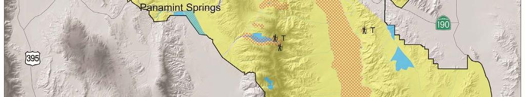
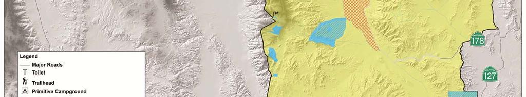
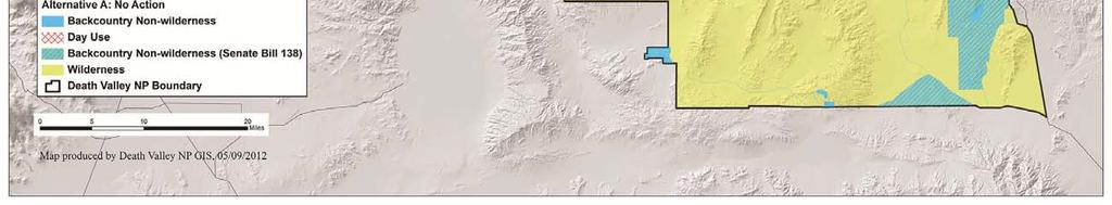
53 CHAPTER TWO ALTERNATIVES Figure 3. Map of Alternative A: No-action 33
54 CHAPTER TWO ALTERNATIVES Commercial Services and Special Park Uses Permit Process: Permit requests would be handled on a case by case basis. The conditions below list the activity areas that would be permitted, and the restrictions that would be enforced by the park, under the noaction alternative. Day Use Motorcycle Groups: One event per location per day and travel restricted to backcountry roads only. Group size limited to 40 motorcycles and 40 people per group. Day Use 4-wheel-drive Groups: One event per location per day and travel restricted to existing backcountry roads only. No group size limits defined. Day Use Hiking and Photography Groups: Allowed in both backcountry and wilderness, limited to 15 people per group. Day Use Guided Bicycle Groups: Bicycle use allowed on backcountry roads only, no off-road travel permitted. No group size limits defined. Day Use Running Sporting Events/Groups: Allowed on West Side Road and Titus Canyon Road only. No group size limits defined. Day Use Bicycle Sporting Events/Groups: Allowed on West Side Road and Titus Canyon Road only. No group size limits defined. Overnight Motorcycle Groups: One event per location per day and travel restricted to existing backcountry roads only. No more than 15 people and 6 vehicles total. Overnight 4-wheel-drive Groups: One event per location per day and travel restricted to existing backcountry roads only. No more than 15 people and 6 vehicles total. Overnight Bicycle Groups: One event per location per day and travel restricted to existing backcountry roads only. No more than 15 people and 6 vehicles total. Overnight Backpacking / Hiking Groups: Support vehicle travel restricted to existing backcountry roads, foot travel authorized in backcountry and wilderness. No more than 15 people and 6 support vehicles total. Overnight Historic Wagon Train Events: One event per year and travel restricted to Harry Wade Road and West Side Road only. Approximately 15 wagons and 4 support vehicles. Overnight Historic Equestrian Events: One event per year and travel restricted to Warm Springs/Butte Valley Road and West Side Road only. Approximately 75 horses and 80 people. Approximately 20 support vehicles Backcountry Facilities Primitive campgrounds: There would be continued use of existing primitive campgrounds located at Eureka Dunes and Homestake Dry Camp. Campsites at these campgrounds would continue to be poorly delineated, with few facilities. Eureka Dunes has a vault toilet, and Homestake Dry Camp has a plastic outhouse. Designated Roadside Camping Corridors: None Dispersed Roadside Camping: over 700 miles of backcountry roads would be open for self-directed use. Site selection would be on a first-come first served basis and visitors would be informally encouraged to camp in previously used campsites in order to minimize campsite proliferation. Trails and Trailheads: Existing trailheads would continue to provide hiking opportunities at Telescope Peak, Wildrose Peak, Natural Bridge Canyon, Golden Canyon, Zabriskie Point, Keane Wonder Mine, Salt Creek, Mesquite Flat Sand Dunes, Badwater, Ubehebe Crater, and Mosaic 34
55 CHAPTER TWO ALTERNATIVES Canyon. The configuration and information available at each trailhead would continue to be highly variable. These trailheads provide access to 23 miles of designated trails. Backcountry Cabins: Approximately two dozen cabins in the backcountry would be available for public use on a first come, first serve basis with a seven day stay limit. No determination of habitability would be made. All use would be at one s own risk and some safety hazards would be signed or otherwise identified in certain cabins (e.g. warnings about hantavirus risk). The park would not allow the installation of locks. Some self-directed stewardship activities would continue to be undertaken without NPS knowledge or consent in order to modify or maintain structures to better meet the expectations of the cabin users. Campfire Rings: No campfires would be allowed except in firepits in designated campgrounds and campsites. No fuel wood collection would be allowed. Signs: Very few interpretive or wayfinding signs would exist outside of the main travel routes. Major backcountry road junctions might or might not be signed, and a variety of sign styles would be used Administrative Activities Overnight Visitor Use Permits: Voluntary overnight wilderness permits would be issued in the Furnace Creek Visitor Center and Stovepipe Wells Ranger Station for free during business hours. Administrative Camps: There would be no no established administrative camps, though various sites could be used to accommodate administrative groups (e.g. research groups, work crews, etc.) on an as needed and as available basis. Visitor Information and Education: Informally, the park would use Leave No Trace and Tread Lightly messages, but application would be inconsistent and messages varied. Other than the general direction contained in the Death Valley National Park Long Range Interpretive Plan, there would be no specific strategy to provide the right message to the right audience at the right time in order to elicit the desired response. Aviation: Air tours would be managed as prescribed in the Air Tour Management Plan, when that plan is complete. Military overflight issues are legislatively outside the scope of this planning effort but NPS would continue to work cooperatively with Department of Defense managers to resolve problems. Private airplane use would continue to be managed by Federal Aviation Administration (FAA) but the NPS would continue to work cooperatively with FAA to resolve problems. Research Permits: Research permit requests would be evaluated on a case by case basis. Resource Management: Minimum requirements analysis would be required when proposed actions may involve prohibited acts in wilderness as described in section 4(c) of the Wilderness Act (e.g. use of motorized equipment, landing of aircraft, mechanical transport, structures or installations). Such analysis would be undertaken on a case by case basis Costs The cost of implementing the no-action alternative was estimated using FY2011 budget analysis for all divisions of Death Valley National Park. Each park division identified those program areas and costs that intersected directly with backcountry and wilderness management, and provided this data to park management. Significant (greater than $100,000) one-time program expenditures were then removed from the estimate, as these would not reflect a state of no action. Any costs that resulted from management at Saline Valley Warm Springs were also removed, as this plan does not address Saline Valley Warm Springs, an area which will be fully addressed in a site-specific EIS planning process. All other program expenditures were considered normal and routine, and were included. The resulting cost estimate of implementing the noaction alternative in FY2011 dollars would be $1,188,974 per year. 35
56 CHAPTER TWO ALTERNATIVES 2.2 ZONE DESCRIPTIONS USED TO DESCRIBE ACTION ALTERNATIVES (ALTERNATIVES B-D) These zones and zone descriptions only apply to alternatives B, C, and D; they do not apply to the no-action alternative for the reasons described in section The zone descriptions are presented in their entirety here in order to provide context for the action alternatives that follow in sections 2.3 through Purpose of Zoning Management zoning is the method used by the National Park Service to identify and describe the appropriate variety of resource conditions and visitor experiences to be achieved and maintained in the different geographic areas of a park. Zoning is generally a two-step process: (1) identify a set of potentially appropriate management zones, and (2) allocate those zones to geographic locations throughout the park. Differences in opinion about optimal and/or feasible resource conditions and visitor experiences for particular areas are addressed through alternative ways to apply zones to the park, thus resulting in different action alternatives. Zoning is intended to provide for a variety of resource conditions and visitor uses that are compatible with the park s purpose and preserve its fundamental resources and values; thus, wilderness lands are zoned in such a way that wilderness character would be maintained or improved. Zoning is an administrative tool and cannot be used to alter the requirements of the Wilderness Act, or the California Desert Protection Act Wild Zone This zone would only apply to congressionally designated wilderness, which is the vast majority of the park. It is the default zone for wilderness lands and such lands would only be re-zoned as high use or directed use if needed to maintain or improve wilderness character due to either the amount or type of visitor use at that location or due to the inherent sensitivity of the resources which dictate a higher level of management presence and visitor direction. If additional lands are designated as wilderness by an act of Congress, those areas would automatically be included in the Wild Zone. The Wild Zone is designed to embrace all of the experiential attributes of wilderness for park visitors and highlights the wilderness character quality of outstanding opportunities for solitude or a primitive and unconfined recreation. Recreational pursuits in this zone are self-directed and require a high degree of selfreliance due to the intentional lack of visitor facilities. This zone provides ample opportunity for adventure, the use of primitive skills, as well as physical and mental challenge. This zone is also the premier place in the park to experience natural sounds, natural odors, dark night skies, and broad vistas where modern human presence is nearly imperceptible. This zone does include layers of human history to be discovered by modern park visitors, including many pre-historic and historic resources that provide an opportunity for visitors to reflect on past human relationships with the land. Other attributes of the Wild Zone are summarized in tables 1, 2, and Backcountry Exploration Zone This zone would apply to non-wilderness backcountry lands. This zone is generally accessed by 4-wheel-drive vehicles and typically includes backcountry lands that are not designated wilderness as well as backcountry 36
57 CHAPTER TWO ALTERNATIVES roads that are not through roads or where road conditions are such that they require highly skilled operators and/or specialized vehicles for safe travel. There is very limited NPS maintenance on these roads, though extreme conditions may be moderated by the volunteer stewardship efforts of backcountry road organizations and enthusiasts. Signs and visitor use facilities are very limited, typically focused on warning signs of a regulatory nature, so visitor use in this zone is largely self-directed. This zone provides good opportunities for self-reliance, challenge, and adventure. Many of these roads were originally built to access mines or homestead sites, the remains of which provide a sense of discovery and an opportunity for visitors to reflect on past human relationships with the land. Other attributes of the Backcountry Exploration Zone are summarized in tables 1, 2, and Backcountry Corridor Zone This zone would apply to non-wilderness backcountry lands. This zone is generally accessed by high clearance, but not necessarily 4-wheel-drive vehicles traveling on unpaved roads. These are the through roads that serve as the primary connectors or travel corridors in the network of backcountry roads in the park and may connect to primary backcountry roads outside the park boundary. Wayfinding, regulatory, and interpretive signs may be present. Other facilities are infrequent but may be present (e.g. research equipment). Roads are periodically maintained in a passable condition by the NPS or other agencies via cooperative agreements, though road condition may be somewhat variable due to the dynamic nature of unpaved roads and extreme weather events. These areas experience a relatively high visitor use and NPS presence, which tends to moderate opportunities for self-reliance, challenge, and adventure. There are numerous and typically well-known cultural features visible along these roads that many visitors find interesting or inspiring, some of which are highlighted with interpretive signs while others are less obvious and can still be discovered by visitors. Other attributes of the Backcountry Corridor Zone are summarized in tables 1, 2, and High Use/ Directed Use Zone This zone would apply to both wilderness and non-wilderness backcountry lands or more typically, geographically small areas that include both. This zone includes popular destinations that seasonally or often see high visitor use. To accommodate such use and protect park resources, these areas typically have a higher level of visitor facilities and visitor services. Facilities are often installations that are prohibited in wilderness, so in most cases the facilities occur on adjacent non-wilderness lands but the visitor destination is in wilderness. For example, a trailhead with parking area, signs, and toilet is accessible by vehicle and located on non-wilderness lands but the popular destination is the hiking route or trail that is accessed from the trailhead and enters wilderness in order to reach a particular destination. There are other locations where this zone is used to provide a higher level of management presence and visitor use direction due to the inherent sensitivity of park resources, rather than as a result of high visitation. In these locations, any visitor use (not just high visitor use) needs to be carefully directed to avoid impacts to the park s natural or cultural resources. This zone is still largely characterized as a natural landscape, but the presence of modern humans is obvious in the form of parking areas, signs, toilets, barriers, and people. Generally, there are fewer opportunities to experience the solitude as visitors would seldom be alone or out of sight of clues of modern human presence. There are also fewer opportunities for primitive and unconfined recreation because the use levels and/or resource sensitivities of these locations require that visitors adhere to agency direction such as stay on trails or no overnight use. This zone still provides opportunities for adventure, discovery, self-reliance and challenge, but the amount of agency presence in these locations tends to moderate the extremes. Cultural resources are 37
58 CHAPTER TWO ALTERNATIVES often high use destinations so this zone provides an opportunity for the NPS to help visitors gain understanding of past human relationships with the land through interpretive programs, signs, and other media. Likewise, some cultural resources are also sensitive to visitor use and so in some locations visitor use restrictions could be imposed for the protection of cultural resources. Other attributes of the High Use/ Directed Use Zone are summarized in tables 1, 2, and 3. In addition, because directed use is an inherent part of this zone, additional information about where and how that direction would occur is found in section
59 CHAPTER TWO ALTERNATIVES Table 6. Zones summarized relative to resource stewardship and resource condition Wild Zone Backcountry Exploration Zone Backcountry Corridor Zone High Use / Directed Use Zone This zone provides for highly focused protection of critical resources consistent with maintaining or improving the natural quality of wilderness character. There would tend to be less active management or manipulation of intact physical or biological resources and processes in order to maintain the untrammeled quality of wilderness character. There would be a very low tolerance for unnatural sounds and light sources as such intrusions degrade both the natural quality of wilderness character and outstanding opportunities for solitude. There would be active management to improve the undeveloped quality of wilderness character by removing defunct installations and debris that are not cultural resources. Restoration of biophysical processes may be appropriate and managed with active NPS oversight. Restoration may be active or passive in nature. Any restoration activity would take place in accordance with the Wilderness Act. Such actions would carefully weigh the impacts to both the untrammeled and the natural quality of wilderness character. Scientific research would be encouraged but strictly managed within this zone. There would be a very low tolerance for research installations and existing defunct research installations would be actively removed. Cultural resource management in this zone would focus on inventory and condition assessments; preservation treatments would be considered using a minimum requirements decision process as needed. Exotic plant and animal species would be actively controlled and contained to mitigate impacts to resources and visitor use. Resource protection would be balanced with providing visitor use opportunities. Sensitive resources would be provided the maximum protection possible. There would be a low tolerance for unnatural sounds and light sources, though some noise and light pollution is expected in association with vehicle use. There would be active management to improve the undeveloped quality of wilderness character by removing defunct installations and debris that are not cultural resources. Restoration of biophysical processes would be appropriate and considered on a site by site basis, though some alteration of biophysical processes would persist due to the presence of the roads and their inherent alteration of surface hydrology. Scientific research would be appropriate and encouraged in this zone especially if it does not impact safety, visitors, or resources. Cultural resource management in this zone would focus on identification, evaluation, monitoring, and inspection to enable the longterm preservation Exotic plant and animal species) would be actively controlled and contained to mitigate impacts to resources and visitor use. Resource protection would be balanced with providing visitor use opportunities. Sensitive resources would be provided the maximum protection possible. There would be more resource stewardship activities in this zone than in the Backcountry Exploration Zone due to higher levels of visitor use and the resulting impacts. There would be a higher tolerance for unnatural sounds and light sources than in the Backcountry Exploration Zone and vehicle noise and lights would be a more common occurrence. There would be active management to improve the undeveloped quality of wilderness character by removing defunct installations and debris that are not cultural resources. Restoration of biophysical processes would be appropriate and considered on a site by site basis, though some alteration of biophysical processes would persist due to the presence of the roads and their inherent alteration of surface hydrology. Due to relatively high visitor use and road capacity in this zone, the impacts to natural processes would be greater than in the Backcountry Exploration Zone. Scientific research would be appropriate and encouraged in this zone especially if not impacting safety, visitors, and resources. There would be opportunities to interpret scientific research to visitors. Cultural resource management in this zone Exotic plant and animal species would be controlled and contained to mitigate impacts to resources and visitor use. Resource protection would be balanced with providing visitor use opportunities. Sensitive resources in high use areas would be provided the maximum protection possible. In wilderness, such actions would be carefully considered for their potential to degrade or improve wilderness character. Permanent lighting would be dark sky friendly. There would be a moderate tolerance for daytime unnatural sounds and a low tolerance for nighttime unnatural sound. There would be active management to improve the undeveloped quality of wilderness character by removing defunct installations and debris that are not cultural resources. There would be a moderate tolerance for disruption to biophysical processes, but where those processes are significantly altered restoration activities would be undertaken to mitigate impacts of human use. There would be a high tolerance for research activities that do not significantly impact recreational or resource values of sites. In wilderness, installations would rarely be appropriate. Research that can only be conducted in wilderness or is important to informing management of park wilderness resources may be permitted. In backcountry, temporary installations that are not highly visible or intrusive would be appropriate. Research of all types would be expected to occur within this area (social sciences, etc.). There would be opportunities to interpret scientific research to park visitors. Cultural resource management in wilderness lands 39
60 CHAPTER TWO ALTERNATIVES The integrity of ethnographic resources is preserved and protected through consultation with area tribes. Such actions would carefully consider both the historic significance of the resource and the preservation of wilderness character. There would a limited range of interpretive techniques (e.g., handouts, visitor contacts) or no interpretation of historic properties. of a resource s historic features, qualities and materials. The integrity of ethnographic resources is preserved and protected through consultation with area tribes. Cultural sites would likely be a primary visitor attraction in this zone. Cultural sites would be protected from impacts of visitor use and to mitigate safety hazards. would focus on identification, evaluation, monitoring, and inspection to enable the longterm preservation of a resource s historic features, qualities and materials. The integrity of ethnographic resources is preserved and protected through consultation with area tribes. Cultural sites would be a primary visitor attraction in this zone. Cultural sites would be protected from impacts of visitor use and to mitigate safety hazards. would focus on inventory and condition assessments; preservation treatments would be considered using a minimum requirements decision process as needed. Such actions would carefully consider both the historic significance of the resource and the preservation of wilderness character. Cultural resource management in non-wilderness lands would focus on identification, evaluation, monitoring, and inspection to enable the longterm preservation of a resource s historic features, qualities and materials. The integrity of ethnographic resources is preserved and protected through consultation with area tribes. Cultural sites that are a primary attraction at high use areas would be protected from impacts of visitor use and to mitigate safety hazards. There would be opportunities to interpret cultural resources. 40
61 CHAPTER TWO ALTERNATIVES Table 7. Zones summarized by visitor experiences Wild Zone Backcountry Exploration Zone Backcountry Corridor Zone High Use / Directed Use Zone Visitors would very rarely encounter other parties, and group sizes would be small. Visitor access and travel routes for hiking would be unrestricted. This zone would offer abundant opportunities to experience solitude, dark night skies, natural sounds, and clear vistas. The sense of solitude and remoteness would be easily realized. Recreational facilities such as trails and NPS wayfinding markers such as rock cairns or posts would be infrequent, but allowed in wilderness. There would be abundant opportunities for challenge, adventure, and discovery in self-directed recreational pursuits. Volunteer stewardship activities would not be emphasized but might be accommodated under the direction of the NPS. Types of stewardship activities could include but not be limited to archeological studies, site restorations, non-historic debris removal, and invasive weed management. Visitor education is obtained prior to travel into this zone. Most of the visitor information is focused on providing the skills and knowledge to promote safety in self-directed recreational pursuits. NPS provided visitor education is primarily through off-site or remote delivery methods. Visitors would rarely encounter other parties in this zone, though the presence of modern humans would be obvious due to the road network. The quality of the natural soundscape would be moderate to high during the day (due to vehicle noises) and high at night. Quality of night sky may be moderate to high depending on proximity to headlights. The sense of solitude and remoteness could be realized in most places during most seasons. Recreational facilities might include minimally maintained or unmaintained unpaved roads, existing cabins, a few signs (mostly regulatory), potential for campfire facilities, and roadside campsites used for dispersed camping. There would be moderate opportunities for self-reliance and most recreational pursuits would be selfdirected. Volunteer stewardship activities would be accommodated under the direction of the NPS. Types of stewardship activities could include but not be limited to archeological studies, site restorations, nonhistoric debris removal, and invasive weed management. Visitor education is focused on minimal health and safety (hantavirus, hazardous mines). Wayfinding and interpretive waysides are closely scrutinized in this zone and would not be appropriate in most cases. Visitors would likely encounter other parties in this zone, most likely in passing on the road and where roadside camps are occupied. Most pursuits within this zone could be done with minimal close encounters with other parties, except at popular destination points where there may be several vehicles and parties at a time. The quality of the natural soundscape would be low to moderate during the day (due to vehicle noises) and high at night. Quality of night sky may be moderate to high depending on proximity to headlights. The sense of solitude and remoteness could be realized in some places and during some seasons. Recreational facilities would likely include maintained unpaved roads, existing cabins, a few signs (regulatory, wayfinding, and interpretive), potential for campfire facilities, and roadside campsites used for dispersed or designated camping. There would be moderate opportunities for self-reliance and most recreational pursuits would be self-directed. Volunteer stewardship would be encouraged under NPS direction. Types of stewardship activities could include but not be limited to archeological studies, site restorations, non-historic debris removal, resource condition monitoring, and invasive weed management. A full range of visitor education opportunities are appropriate in this zone, including signs, podcasts (or similar technological delivery methods), and ranger guided hikes or activities. 41 Encounter rates could be high and group sizes would be highly variable, but group sizes could be quite large (e.g. when a tour bus stops at the access point).generally there would be a high likelihood of encountering other people or signs of other people in this zone. Quality of the natural soundscape would typically be low to moderate during the day depending on level of use and high at night. Quality of night sky may range from low to high depending on level of visitor use, particularly due to vehicle lights and occasionally nearby outdoor lighting. Minimal opportunity for solitude and sense of self-reliance. Roads may be frequent in backcountry. Trails would be NPS defined. There would be low tolerance for social trails. New trails may be created to provide a variety of recreational experiences and to protect sensitive resources. Human waste management would be considered. NPS created signs and waysides would be frequent in backcountry. NPS wayfinding signs would be infrequent but allowed in wilderness. Campsites may be designated. Volunteer stewardship would be encouraged under NPS direction. A wide variety of activities might be accommodated here. Resources would be actively interpreted both on-site and off-site. Ranger led tours, waysides, and signs would be appropriate.
62 CHAPTER TWO ALTERNATIVES Table 8. Zones summarized by administrative uses/actions Wild Zone Backcountry Exploration Zone Backcountry Corridor Zone High Use / Directed Use Zone Consistent with the Wilderness Act there is no tolerance for new permanent communication/utility installations. The need for existing installations (pre-dating the designation of wilderness) would be re-evaluated by NPS and removed when no longer necessary or appropriate. Non-historic debris removal would be a priority in this zone but the tools and techniques used will be carefully evaluated using the minimum requirements decision analysis process. Consistent with the Wilderness Act, commercial services would generally be prohibited in this zone except to the extent necessary to realize the purposes of wilderness. Similarly, most special park uses in this zone would be limited. Sporting events and historic wagon train and equestrian events would not be permitted and group sizes would be limited. Wireless communication towers would not be allowed in this zone. Self reliance and self rescue (including communication technologies) would be emphasized in this zone. Access to emergency services would likely be very difficult and response times may be extremely long. There would be a low presence of NPS personnel in this zone, consisting primarily of resource management and law enforcement personnel. There would be a moderate tolerance for existing installations and a low tolerance for new installations. Existing installations that are no longer needed would be removed. Road counters would be common. Non-historic debris removal would be undertaken where it detracts from visitor experience or is impacting resources. Commercial services and special park uses that support visitor access and enjoyment would be allowed. Number of, frequency of, and type of special park uses and/or commercial services would be carefully considered to avoid impacts to visitor backcountry experience and resources. Sporting events and historic wagon train and equestrian events would not be permitted and group sizes would be limited. Self reliance and self rescue (including communication technologies) are emphasized. Access to emergency services may be difficult and response times may be long. There would be a low to moderate presence of NPS personnel in this zone, consisting primarily of resource management and law enforcement personnel. There would be a high tolerance for existing installations and a moderate tolerance for new installations. Existing installations that are no longer needed would be removed promptly. Road counters and road engineering structures would be common. Non-historic debris removal would be undertaken where it detracts from visitor experience or is impacting resources. Commercial services that support visitor access and enjoyment of backcountry would be allowed. Many types of special park uses would be permitted in backcountry as long as they would not interfere with visitor use or impact resources. Self reliance and self rescue (including communication technologies) are encouraged. Access to emergency services may be difficult in places and response times may be short or long. There would be a moderate to high presence of NPS personnel in this zone, including maintenance, law enforcement, interpretation, and resource management personnel. There would be a high tolerance for existing installations and a moderate tolerance for new communications installations in backcountry. There would be no tolerance for utilities and communication installations in wilderness. Existing installations that are no longer needed would be removed promptly. Non-historic debris removal would be a priority in this zone, particularly where it detracts from visitor experience or is impacting resources in wilderness lands. Removal actions in wilderness will be carefully evaluated using the minimum requirements decision analysis process. Commercial services in non-wilderness backcountry that support visitor access and enjoyment of backcountry would be allowed. Commercial services in wilderness would generally be prohibited except to the extent necessary to realize the purposes of wilderness. Similarly, many types of special park uses would be permitted in backcountry areas as long as they would not interfere with visitor use or impact resources, but in wilderness sporting events and historic wagon train and equestrian events would not be permitted, and group sizes would be limited. Self reliance and self rescue (including communication technologies) are encouraged. Emergency services are relatively accessible and response times may be short or long. There would be a high presence of NPS personnel in this zone, including maintenance, law enforcement, interpretation, and resource management personnel. 42
63 CHAPTER TWO ALTERNATIVES Visitor Use Strategies for Specific Locations in the High Use/Directed Use Zone Section of NPS Management Policies 2006 states: The wilderness management plan will identify desired future conditions, as well as establish indicators, standards, conditions, and thresholds beyond which management actions will be taken to reduce human impacts on wilderness resources. An essential element of the action alternatives would be to establish a management framework that addresses current trends and opportunities and also provides guidance for managers to adapt actions as trends change. These are the primary elements in this management framework required to fulfill the agencies policy mandate: Desired conditions provides a picture of the desired wilderness or backcountry conditions for each management zone. Indicators/Measures track conditions to assess progress at attaining desired conditions and preserving wilderness character. Standards are management decisions on the minimum acceptable condition for measures, and serve as triggers for management action. Management actions are implemented, after a problem analysis, to maintain or restore desired conditions. Figure 4 shows the decision process used at Death Valley to develop the visitor use management framework. The vast majority of the park experiences low visitation and the existing condition assessment found that in those areas the desired condition was being realized. For those areas, the park will follow the top pathway of figure 4 and continue to monitor and report on trends in wilderness character as outlined in appendix G. The decision to take a less active approach to management of sites where existing conditions are largely acceptable was deliberate on the part of park managers in order to maximize the opportunities for primitive and unconfined recreation while still protecting park resources. Several locations were identified by park staff, cooperators, and the public as being locations where visitor use impacts were a concern. These locations became the focus of a visitor use analysis to better understand the underlying cause(s) of the impacts and to explore what could be done to avoid, minimize, or mitigate the impacts. Why actions are being considered is summarized in table 4 and discussed in the affected environment section, chapter 3. What is proposed to be done to address the issue is included in the three action alternatives presented in the next section, primarily focused on the specific locations that are zoned for high use/directed use. However, not all of the same locations are zoned for high use/directed use in all three alternatives. The differences reflect the different concepts that underlay the alternatives, where alternative B takes a reactive approach to intervene only when and where standards are clearly exceeded, while alternative C takes a proactive approach to intervene where standards are exceeded or potentially exceeded during the life of this plan, and alternative D takes a focused approach to intervene where standards are currently exceeded as well as where and when conditions are currently approaching standard. How these management actions are actually implemented is found in the appendices, which are meant to be living documents that are periodically updated as information changes, technology improves, or conditions change, provided that the implementation details stay consistent with the actions identified and analyzed in this environmental assessment. 43


64 CHAPTER TWO ALT TERNATIVES Figure 4. Decision process for identifying area specific visitor use management strategies, including use limits. 44
65 CHAPTER TWO ALTERNATIVES Table 9. Visitor use issue analysis and strategies for specific locations managed for high use / directed use (8 pages). How these measures are undertaken is discussed in appendix G and how the education strategy is implemented is discussed in appendix I. Location Applicable to Issue Proposed Proposed Proposed Management Strategy these Alternatives Measures Standards Aguereberry Point (backcountry) B, C, D Improper disposal of human waste Butte Valley and Warm Springs Cabins (backcountry) Crowding due to frequency of encounters with other parties C, D Improper disposal of human waste at cabins, especially during high use seasons and near springs Unauthorized maintenance or alterations to cabins Number of encounters of improper human waste disposal Number of encounters with other visitor groups per hour Number of encounters of improper human waste disposal Number and severity of Incidence of unauthorized cabin work No or limited incidence of improperly disposed human waste No more than an average of three encounters with other visitor groups per hour No or limited incidence of improper disposal of human waste No unauthorized cabin maintenance or alterations No NPS Interpretive groups and no Special use permit groups over 20 participants. Revise terms and conditions for special use permits to include proper human waste disposal. Implement visitor education regarding proper human waste disposal. Require pack-out of human waste during high use seasons or provide on -site toilet facilities. Establish a cabin stewardship program to facilitate cabin maintenance activities by interested groups and individuals under NPS direction with proper care for historic materials and worker safety. Corkscrew Peak (wilderness) C Rendezvous of large groups at cabin sites without permits thus exceeding the site capacity Multiple routes and visitor created route markers Presence/absence of posted warning signs at cabins regarding hanta virus and other concerns Presence of visitor constructed fire rings near cabins Number of large groups at each cabin site at the same time Visitor complaints regarding difficulty in route finding All cabins posted with visitor safety warnings No visitor created campfire rings No more than two special use permit groups per week. No more than 6 complaints per year Conduct bi-annual inspection and replacement of warning signs Remove visitor campfire rings Maintain one well constructed and safely located firepit at each cabin and routinely remove all unauthorized firerings Manage all groups via special use permits (appendix G). Operate cabins as administrative sites for specific park purposes. Establish clearly marked route from existing parking area at Hells Gate to top of Corkscrew Peak. 45
66 CHAPTER TWO ALTERNATIVES Location Cottonwood Canyon/Marble Canyon Hiking Loop (backcountry and wilderness) Darwin Falls (backcountry and wilderness) Applicable to Issue these Alternatives B, C, D Improper disposal of human waste especially in and near the spring brook Crowding due to frequency of encounters with other parties and competition for optimal campsites during high use seasons Disturbance to nesting riparian birds by visitors B, C, D Improper disposal of human waste Crowding due to frequency of encounters with other parties Desolation Canyon C Crowding due to frequency of encounters with other parties Proposed Measures Number of encounters of improper human waste disposal Number of encounters with other visitor groups when more than two miles from end of road Incidence of nest abandonment or reduction in nesting success Number of encounters of improper human waste disposal Number of encounters with other visitor groups per hour Number of encounters with other visitor groups per hour Proposed Standards No more than one incidence of improperly disposed human waste per campsite No more than 4 encounters per day No incidence of nest abandonment due to visitor encounters No incidence of improperly disposed human waste No more than an average of three encounters with other visitor groups per hour No more than an average of five encounters with other visitor groups per hour Proposed Management Strategy Require that human waste be packed out during high use seasons and when large groups are permitted. Manage the road and hiking corridors for designated camping rather than dispersed camping. Implement an overnight use permit system as necessary to allocate campsites. Manage groups under a special use permit with specific terms and conditions. Designate and mark a hiking trail through Cottonwood Canyon to avoid disturbance of birds. Avoid establishing campsites near nesting habitat. NPS Interpretive groups and Special use permit groups limited to no more than 20 participants. Formalize trailhead with designated parking, low maintenance toilet facility, and visitor use information sign. Establish formal trailhead with visitor use information. NPS Interpretive groups and Special use permit groups limited to no more than 20 participants. Do not pave access road. 46
67 CHAPTER TWO ALTERNATIVES Location Eureka Dunes (backcountry and wilderness) Indian Pass (frontcountry parking and wilderness) Applicable to Issue these Alternatives C, D Improper disposal of human waste Proliferation of out of bounds campsites Illegal off road travel, especially along east side of dunes Illegal sandboarding Disturbance to archeological sites/illegal artifact collection C, D Improper disposal of human waste Crowding due to frequency of encounters with other parties Unsafe parking along Highway 190 and associated damage to road shoulder Proposed Measures Number of encounters of improper human waste disposal Number of out of bounds campsites or parking areas Linear feet of new tracks encountered monthly Number of sandboarding incidence documented per month Number of illegal collecting incidence documented per month by law enforcement personnel; archeological site condition Number of encounters of improper human waste disposal Number of encounters with other visitor groups per hour Number of vehicles parked along Highway 190 near route origin Proposed Standards No incidence of improperly disposed human waste No out of bounds camping No new tracks No incidence of sandboarding No incidence of illegal collection or disturbance; archeological sites conditions do not degrade due to visitor activities No more than 3 incidence of improperly disposed human waste along primary hiking route No more than an average of three encounters with other visitor groups per day No vehicles parked overnight along road shoulder (after construction of new parking area) Proposed Management Strategy Establish designated campsites along east side of dunes outside of archeological sites, one would be a group campsite. No dispersed camping allowed within 2 miles. Upgrade or replace the existing vault toilet to ensure a locking door, an acceptable seat, and increased capacity. Install a second low maintenance toilet on east side of dunes outside of archeological sites. Increase maintenance frequency of toilet facilities and/or increase capacity of existing toilet. Support a campground host at this site during heavy use periods. Increase visitor education both on-site and off-site, improve visitor use signs. Do not pave the road. Require permits for overnight use. Establish a trailhead with a small graded parking area to accommodate a few vehicles off the highway for overnight parking. Provide a trailhead sign with visitor use information, including information regarding proper disposal of human waste and alternative backpacking routes when the parking area is full. If campsite proliferation at the canyon becomes a problem, consider establishing designated campsites and prohibiting dispersed camping. 47
68 CHAPTER TWO ALTERNATIVES Location Keane Wonder Mine (after safety concerns are addressed and site is re-opened to the public) (backcountry and wilderness) Mesquite Flat Dunes (backcountry and wilderness) Mosaic Canyon (backcountry and wilderness) Applicable to Issue these Alternatives B, C, D Sensitive historic resources Improper disposal of human waste Crowding due to frequency of encounters with other parties B, C, D Sensitive cultural resources Illegal off road travel B, C, D Improper disposal of human waste Crowding due to frequency of encounters with other parties Out of bounds parking when lot is at capacity Proposed Measures Incidents of visitor caused damage to historic resources Number of encounters of improper human waste disposal Number of encounters with other visitor groups per hour Incidents of illegal camping Linear feet of new tracks encountered monthly Number of encounters of improper human waste disposal Number of encounters with other visitor groups per hour Number of vehicles parked out of bounds per hour during high use periods Proposed Standards No incidence of damage to historic resources No incidence of improperly disposed human waste No more than an average of three encounters with other visitor groups per hour No incidence of illegal camping No new tracks No incidence of improperly disposed human waste No more than an average of seven encounters with other visitor groups per hour No more than 2 incidents of out of bounds parking per day. Proposed Management Strategy Install low maintenance toilet facility. Do not enlarge the parking lot or pave the road. Limit size of NPS interpretive walks to no more than 20 participants during busy periods. Do not issue special use permits for groups larger than 20. Implement visitor education strategy and post visitor use information regarding visitor safety around mine sites, protection of historic resources, and proper human waste disposal. Maintain area as day use and direct visitor parking and access to the existing parking area. Formalize trailhead including clearly delineated parking area, low maintenance toilet, and visitor information signs. Post areas as no parking where needed to avoid out of bounds or overflow parking. Limit special use permit groups to no more than 20 participants. Limit NPS interpretive programs to no more than one a day. 48
69 CHAPTER TWO ALTERNATIVES Location Natural Bridge (backcountry and wilderness) Applicable to Issue these Alternatives B, C, D Out of bounds parking when lot is at capacity Crowding due to frequency of encounters with other parties Proposed Measures Number of vehicles parked out of bounds per hour during high use periods Number of encounters with other visitor groups per hour Proposed Standards No more than 2 incidents of out of bounds parking per day. No more than an average of seven encounters with other visitor groups per hour below the bridge or three per hour beyond the bridge. Proposed Management Strategy Formalize trailhead including clearly delineated parking area near existing toilet facility, and post visitor information signs. Post areas as no parking where needed to avoid out of bounds or overflow parking. Upgrade toilet capacity if necessary to meet demand. Limit special use permit groups to no more than 20 participants. Limit NPS interpretive programs to no more than one a day. Do not pave access road. Racetrack Playa/ Homestake Dry Camp (backcountry and wilderness) B, C, D People moving, defacing, or stealing the rocks on the playa Crowding at Homestake Dry Camp Improper disposal of human waste Off road vehicle travel on playa Hiking on playa when its wet Crowding at the playa parking area and environs Number of new rockless tracks Number of new visitor created campsites Number of encounters of improper human waste disposal along road between Playa parking area and Homestake Dry Camp Count new vehicle tracks on playa per month Count new footprints per month Number of visitor complaints No rocks moved or removed No camping outside of designated campsites No incidence of improperly disposed human waste No new tracks No new footprints Less than five complaints about crowding per year Include visitor information signs at Racetrack Playa parking area regarding no removal of rocks, no walking on playa when its wet, proper disposal of human waste and no overnight camping. Incorporate similar messages into other visitor education materials. Formally establish Homestake Dry Camp as a primitive campground, including delineated campsites with firepits and picnic tables at each site. Replace existing plastic outhouse with a low maintenance toilet facility. Do not pave road or improve road maintenance. Remove existing roadberm and ditch adjacent to Racetrack Road to restore natural contours to allow natural overland flows from Ubehebe Peak onto the playa. Install low profile fencing outside of wilderness as necessary to prevent off road 49
70 CHAPTER TWO ALTERNATIVES Location Sidewinder Canyon (backcountry and wilderness) Applicable to these Alternatives Issue Altered natural overland flow onto playa due to road berm and ditch previously constructed to prevent off-road travel C, D Improper disposal of human waste Crowding due to frequency of encounters with other parties Proposed Measures Proposed Standards Proposed Management Strategy NA NA travel onto playa. Install strong No Driving on Playa sign on road at northern end of Racetrack Playa. Number of encounters of improper human waste disposal Number of encounters with other visitor groups per hour No incidence of improperly disposed human waste No more than an average of three encounters with other visitor groups per hour Formalize trailhead including clearly delineated small parking area, low maintenance toilet facility, and visitor information signs. Delineate trail as needed up Sidewinder Canyon. Limit size for NPS interpretive walks to no more than 12 or consider no NPS guided activities at this location. Do not authorize this site for special use permit groups or commercial use groups. Skidoo Historic Site (backcountry) Surprise Canyon (NPS managed portion only) (backcountry and wilderness) B, C, D Sensitive historic resources Improper disposal of human waste Crowding due to frequency of encounters with other parties B, C, D Improper disposal of human waste Incidents of visitor caused damage to historic resources Number of encounters of improper human waste disposal Number of encounters with other visitor groups per hour Number of encounters of improper human waste disposal No incidence of damage No incidence of improperly disposed human waste No more than an average of three encounters with other visitor groups per hour No more than two incidence of improperly disposed human waste observable from the trail Manage site for day use only. No roadside camping. Implement visitor education strategy and post visitor use information regarding visitor safety around mine sites, protection of historic resources, and proper human waste disposal. No NPS interpretive groups and no special use permit groups over 20 participants. Revise terms and conditions for special use permits to include proper human waste disposal. Implement visitor education strategy and post visitor use information regarding visitor safety around mine sites, protection of historic resources, and proper human waste disposal. If standards are still exceeded, coordinate 50
71 CHAPTER TWO ALTERNATIVES Location Applicable to these Alternatives Issue Crowding due to frequency of encounters with other parties Proposed Measures Number of encounters with other visitor groups per hour Proposed Standards No more than an average of five encounters with other visitor groups per day Proposed Management Strategy with BLM for installation of trailhead toilet (on BLM land) or implement a pack it out strategy for high use seasons. Require permits for overnight use and include terms and conditions regarding protection of sensitive resources, proper disposal of human waste and staying on trail. Telescope Peak (backcountry and wilderness) B, C, D Improper disposal of human waste Spur trails and cutting of switchbacks Number of encounters of improper human waste disposal Number of new spur trails No more than an average of three new incidences of improperly disposed human waste for length of trail during primary use season (measured every two months) No more than two new spur trails along the route during primary use season Coordinate with BLM on trail designation and management. Require permits for overnight use and include terms and conditions regarding protection of sensitive resources, proper disposal of human waste, staying on trail, and camping in previously used campsites. Implement Education Strategy. If problems persist consider designated campsites, limiting number of overnight permits issued per day for this area, and/or pack it out requirement for human waste disposal. No special use permits for groups larger than 20. Limit NPS or Death Valley Natural History Association guided hikes to 12 individuals. Titus Canyon (backcountry and wilderness) Proliferation of user defined campsites along route and size creep of existing campsites with frequent use B, C, D Improper disposal of human waste, especially in/near spring and Leadfield historic site Seasonally count number of campsites by quantitative size categories Number of encounters of improper human waste disposal No increase in number or size of campsites No incidence of improperly disposed human waste Manage Titus Canyon for day use only to minimize impacts to bighorn sheep Implement education strategy regarding 51
72 CHAPTER TWO ALTERNATIVES Location Applicable to these Alternatives Issue Archeological site degradation at Leadfield historic site and petroglyph Visitor use causes disruption of bighorn sheep access to Klare Spring for water Crowding around Leadfield and at Klare Spring Proposed Measures Site condition as recorded in ASMIS Persistence of bighorn population in the vicinity Number of encounters with other parties Proposed Standards Maintain or improve condition (poor, fair, good) at each assessment Population remains viable and uses habitat around Titus Canyon/Klare Spring No more than ten encounters with other parties per trip through Titus Canyon Proposed Management Strategy protection of natural (Klare Spring, bighorn sheep) and cultural resources (petroglyph site, Leadfield historic site), and proper disposal of human waste. Limit group size and manage groups under a special use permit with specific terms and conditions. Formalize parking area and limit number of parking spots (about 7) and install low maintenance toilet at Leadfield/Klare Springs vicinity. Develop a self guided site exploration trail around the Leadfield and Klare Springs area to avoid trampling and social trailing. Ubehebe Crater (backcountry) B, C, D Crowding/encounter rates Number of visitor groups inside the Crater at one time No more than an average of five encounters with other visitor groups inside of the crater at any one time Either remove petroglyph sign or develop a more comprehensive interpretive sign and access barrier near the site. To preserve and protect the integrity of sensitive ethnographic resources at Ubehebe Crater, area tribes will be consulted prior to the installation of a large capacity, low maintenance toilet facility below the parking area before road splits. Improper disposal of human waste Number of encounters of improper human waste disposal No incidence of improperly disposed human waste No Special Use Permit groups over 20. Limit NPS interpretive programs to no more than one a day. 52
73 CHAPTER TWO ALTERNATIVES 2.3 ALTERNATIVE B: MINIMUM ACTION ALTERNATIVE Description of the Alternative To fulfill the intent of maximizing outstanding opportunities for solitude or primitive and unconfined recreation, visitor services and park operations would be conducted in a manner that minimizes the imprint of modern humans within the wilderness. There would be no new or very limited new infrastructure and facilities in the backcountry. Resource and visitor experience conditions that are currently unacceptable or that are approaching unacceptable are identified and addressed through targeted management actions using the least intensive management tools suitable to the situation. This alternative would formalize the no-action alternative and add a few specific actions to address current visitor impact issues while fulfilling current agency requirements for wilderness and backcountry administration (e.g. adopting a minimum requirements decision process, evaluating science in wilderness, etc.) Zone Descriptions In this alternative the Wild Zone would be 3,099,000 acres, the Backcountry Exploration Zone would be 205,000 acres, the Backcountry Corridor Zone would be 8,000 acres, and the High Use/Directed Use zone would be 8,000 acres. A map of this alternative is found in figure 5. 53

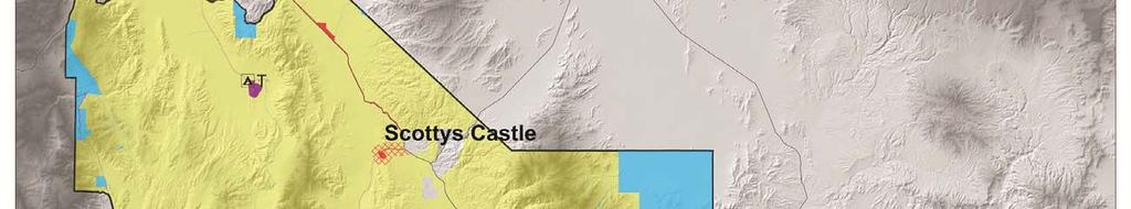
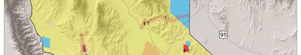

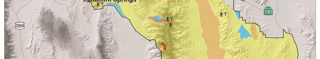
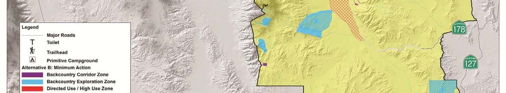
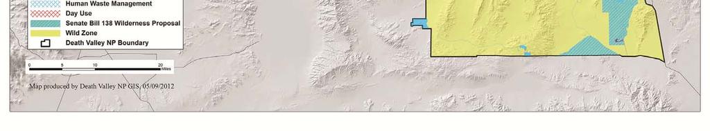
74 CHAPTER TWO ALTERNATIVES Figure 5. Map of Alternative B: Minimum Action Alternative 54
75 CHAPTER TWO ALTERNATIVES Wilderness and Backcountry Management Wilderness Character: All four qualities of wilderness character would be valued and protected. Similar to the no-action alternative, this alternative would provide emphasis for enhancement of the undeveloped quality and outstanding opportunities for primitive and unconfined recreation. Solitude would be abundant, but the lack of visitor restrictions and facilities means that unintentional (and ill-prepared) wilderness users could be encountered in wilderness settings, thus potentially reducing opportunities for solitude. Backcountry Opportunities: This alternative is similar to the no-action alternative in proposing minimal changes to facilities or visitor experiences but would formalize some administrative processes. The small number of new facilities would target existing areas of concern to mitigate unacceptable impacts to park resources. Backcountry opportunities would be abundant but would require more self-reliance and self-direction than Alternatives C or D. Wilderness Dispersed Overnight Use Group Size Limits: 12 individuals per party per night Backcountry Dispersed Overnight Use Group Size: 12 individuals and 3 vehicles per party per night. Human Waste Disposal: A requirement to pack out solid waste and toilet paper using a sanitary system would be implemented along the Cottonwood Canyon and Marble Canyon Loop, including both the roads and hiking route. In addition, there would be new low maintenance toilets constructed at non-wilderness sites at Keane Wonder mine, Darwin Falls trailhead, Leadfield historic site, and Mosaic Canyon trailhead. The site placement, toilet type (e.g. composting, solar dehydration, traditional vault, etc.), and capacity would be determined later based on engineering studies and use conditions. Visitor Use Restrictions: Dispersed camping would not be allowed within 1 mile of all paved roads plus the following graded dirt roads: Titus Canyon, West Side Road, Wildrose, Skidoo Mine, Aguereberry Point Rd, Mosaic Canyon, Cottonwood Canyon Road (first 8 miles), Grotto Canyon Rd, Keane Wonder Mine Rd, Salt Creek Rd., Historic Stovepipe Wells Rd., Racetrack Rd from Teakettle Junction to Homestake Dry Camp, Natural Bridge Canyon, Desolation Canyon, Big Pine Road and along the Death Valley floor from Ashford Mill to 2 miles north of the Mesquite Flat Sand Dunes. In addition, Darwin Falls Trail and the Greenwater Canyon (not Greenwater Road) would be designated as day use only. Carrying Capacity Limits: As indicated in section 2.2.6, specific visitor capacity management actions (including potential use limits) would be implemented at these sites that are zoned for directed use/high use: Aguereberry Point, Darwin Falls, Skidoo Historic Site, Keane Wonder Mine, Mesquite Flat Dunes, Mosaic Canyon, Telescope Peak, Surprise Canyon, and Ubehebe Crater Commercial Services and Special Park Uses Listed below are the commercial services that Death Valley National Park would authorize for permit under this alternative. Non-profit groups may apply for a special use permit for the same activities. The same limits on group size, frequency, and activity locations would apply to commercial use authorizations and non-commercial special use permits. Day Use Motorcycle Groups: One event per location per day and no more than 2 events per location per week. Travel restricted to backcountry roads only. Group size limited to 15 motorcycles per group, plus no more than 2 support vehicles. Day Use 4-wheel-drive Groups: One event per location per day and no more than 2 events per location per week. Travel restricted to existing backcountry roads only. Group size limited to 5 vehicles total. 55
76 CHAPTER TWO ALTERNATIVES Day Use Hiking and Photography Groups: Allowed in both backcountry and wilderness, limited to 10 people per group and 3 support vehicles. One commercial group per day in Mosaic Canyon, Natural Bridge Canyon, and Sidewinder Canyon. Support vehicles restricted to travel on backcountry roads. Day Use Guided Bicycle Groups: One event per location per day. Bicycle use allowed on backcountry roads only, no off-road travel permitted. Group size limited to 20 bikes and no more than 3 support vehicles. Day Use Guided Horse and Pack Animal Trips: One event per location per day. Travel with pack animals restricted to backcountry roads only. Group size limited to 6 animals and no more than 3 support vehicles. Day Use Running Sporting Events: Allowed on West Side Road only. One hundred people and 10 support vehicles maximum. Day Use Bicycle Sporting Events: Not allowed in backcountry or wilderness. Day Use Guided Canyoneering Groups: Not allowed in backcountry or wilderness. Day Use Guided Climbing Groups: Not allowed in backcountry or wilderness. Overnight Motorcycle Groups: One event per location per day and no more than 2 events per location per week. Travel restricted to existing backcountry roads only. No more than 8 people and 4 vehicles total. Overnight 4-wheel-drive Groups: One event per location per day and no more than 2 events per location per week. Travel restricted to existing backcountry roads only. No more than 10 people and 3 vehicles total. Overnight Bicycle Groups: One event per location per day and travel restricted to existing backcountry roads only. No more than 10 people and 3 support vehicles. Overnight Backpacking / Hiking Groups: Foot travel allowed in backcountry and wilderness. No more than 10 people and 3 support vehicles. One commercial group per day in Marble Canyon, Cottonwood Canyon, and Indian Pass Canyon. Support vehicles restricted to travel on backcountry roads. Overnight Horse and Pack Animal Groups: Travel restricted to existing backcountry roads only. No more than 10 people, 6 animals, and 3 support vehicles. Overnight Wagon Train Events: One event per year and travel restricted to existing backcountry roads only. No more than 5 wagons/20 stock/15 people and no more than 2 support vehicles. Overnight Historic Equestrian Events: One event per year and travel restricted to existing backcountry roads only. No more than 20 horses and riders and 5 additional people. No more than 7 support vehicles Backcountry Facilities Unpaved Roads: Approximately 670 miles of existing unpaved roads would be managed as backcountry exploration roads with minimal maintenance by NPS except as necessary to keep road conditions passable by high clearance 4-wheel-drive vehicles. Approximately 270 miles of existing unpaved roads would be managed as backcountry corridor roads, including routine maintenance by NPS or other agencies to keep road conditions passable by 2-wheel-drive vehicles. Primitive campgrounds: No new primitive campgrounds would be developed in this alternative, though some facilities at existing primitive campgrounds at Eureka Dunes and Homestake Dry Camp could be upgraded (e.g. new toilet facilities) as discussed elsewhere in this section. Designated Roadside Camping Corridors: No designated roadside camping corridors would be established. Dispersed Roadside Camping: Approximately 770 miles of backcountry road would be open for selfdirected use. Site selection would be on a first-come first served basis and visitors would be 56
77 CHAPTER TWO ALTERNATIVES informally encouraged to camp in previously used campsites in order to minimize campsite proliferation. Trails and Trailheads: The trailheads at Darwin Falls and Fall Canyon would be formalized. The existing trailheads identified in the no-action alternative would remain unchanged at Telescope Peak, Wildrose Peak, Natural Bridge Canyon, Golden Canyon, Zabriskie Point, Keane Wonder Mine, Salt Creek, Mesquite Flat Sand Dunes, Badwater, Ubehebe Crater, and Mosaic Canyon. Each trailhead would include a place to park and some sort of wayfinding direction to aid visitors in accessing the trail, though the configuration and information available at each trailhead would be highly variable. Some trailheads could also have toilet facilities as indicated elsewhere in this section. These trailheads would provide access to 27 miles of designated trails. Backcountry Cabins: Cabins would be evaluated for historic significance and safety concerns, and over time treatment prescriptions would be developed. Volunteer stewardship activities would implement those treatment prescriptions. Cabins in the backcountry would be available for public use on a first come, first serve basis with a seven day stay limit. All use would be at the visitor s own risk and some safety hazards would be signed or otherwise identified in some cabins (e.g. warnings about hantavirus risk). The park would prohibit the installation of locks, and all fires in cabins would be prohibited. There would be a requirement that human waste be disposed of at least 400 feet from the cabin or packed out, unless there is a park-installed toilet facility. Campfire Rings: Same as the no-action alternative. No campfires would be allowed except in firepits in designated campgrounds and campsites. No fuel wood collection would be allowed. Signs: Same as the no-action alternative. Very few interpretive or wayfinding signs would exist outside of the main travel routes. Major backcountry road junctions might or might not be signed and a variety of sign styles would be used Administrative Activities Overnight Visitor Use Permits: Voluntary overnight wilderness permits would be issued in the Furnace Creek Visitor Center for free during business hours. In addition, Cottonwood Canyon/Marble Canyon Loop (both road sections and backpacking sections) would require mandatory permits for overnight use. Administrative Camps: Same as the no-action Alternative. There would not be any established administrative camps, though various sites could be used to accommodate administrative groups (e.g. research groups, work crews, etc.) on an as needed and as available basis Costs The cost of implementing the minimum action alternative was generated by combining FY2011 budget analysis with budget projections of the specific management actions outlined in the alternative. Each division of Death Valley National Park generated this budget analysis by identifying those program areas and costs that intersected directly with backcountry and wilderness management. Since the minimum action alternative outlines some actions that require one-time project and capital expenditures, the data was further refined to provide both an estimate of the one-time expenses and the cyclic or annual expenses. The estimated cost of implementing the minimum action alternative would be: One-time capital and project expenses: $513,567 Cyclic or annual expenses: $1,380,049 Total expenses: $1,893,616 57
78 CHAPTER TWO ALTERNATIVES 2.4 ALTERNATIVE C: MAXIMUM ACTION ALTERNATIVE Description of the Alternative Outstanding opportunities for solitude or primitive and unconfined recreation would still occur for selfreliant visitors, but there would be more opportunities for park visitors with less experience or lacking specialized equipment. The park would seek opportunities to partner with neighboring land management agencies to provide improved access between the park and adjacent public lands. Where appropriate, new infrastructure and facilities would be developed in backcountry locations to enhance visitor opportunities and mitigate visitor use impacts. Visitor services and park management operations, including field activities, education, outreach, and interpretive programs would likely increase from current levels. Highest priority would be given to addressing locations where impacts of visitor use are currently unacceptable and actions would be taken to manage visitor use or specific aspects of visitor use in order to meet standards. Over time, other locations would receive increased management with the intent of proactively managing visitor use to maintain desired visitor experiences and protect park resources Zone Descriptions In this alternative the Wild Zone would be 3,093,500 acres, the Backcountry Exploration Zone would be 181,000 acres, the Backcountry Corridor Zone would be 18,500 acres, and the High Use/Directed Use Zone would be 27,000 acres. A map of this alternative is found in figure 6. 58


79 CHAPTER TWO ALTERNATIVES Figure 6. Map of Alternative C: Maximum Action 59
80 CHAPTER TWO ALTERNATIVES Wilderness and Backcountry Management Wilderness Character: All four qualities of wilderness character would be valued and protected. This alternative would also enhance the quality of and opportunities for solitude for the visitors who intentionally seek it by providing a contrast with the increased level of visitor services provided in the backcountry; however, there would be some loss of unconfined recreational use due to the associated increase in visitor use restrictions. The undeveloped quality would remain largely unchanged in wilderness but there would be a number of new developments in backcountry sites immediately adjacent to wilderness. Such increased developments and focused visitor use might result in a decrease in naturalness in some areas. For example, in some areas invasive plants may increase as they are spread by visitors. As the park would likely attempt to control the potential spread of invasive plants, there could be an increased potential for degradation of the untrammeled quality. Backcountry Opportunities: This alternative would provide for the largest number of additional designated visitor use locations by formalizing existing visitor use patterns and anticipating future demands. New facilities would be developed to accommodate sustainable visitor use and protect park resources from direct and indirect impacts associated with visitor use. The new facilities and NPS direction would offer a more structured experience for visitors who want it while maintaining abundant opportunities for visitors who want a remote and self-directed experience. Wilderness Dispersed Overnight Use Group Size Limits: 15 individuals per party per night. Backcountry Dispersed Overnight Use Group Size: 15 individuals and 6 vehicles per party per night (unless authorized under a Special Use Permit or in a designated group site). Human Waste Disposal: A requirement to pack out solid waste and toilet paper using a sanitary system would be implemented along the Cottonwood Canyon and Marble Canyon Loop, including both the roads and hiking route. New low maintenance toilets would be added at nonwilderness sites at these locations: Keane Wonder Trailhead, Mosaic Canyon Trailhead, Darwin Falls Trailhead, Salt Wells Campground, Sidewinder Canyon Trailhead, Leadfield historic site, near the Ubehebe Crater parking lot, and Teakettle Junction. The park would replace or upgrade existing toilet facilities at Homestake Dry Camp and Eureka Dunes as well as add an additional toilet to the Eureka Dunes. In addition, the park would install a new toilet or rehabilitate the existing septic system at Warm Springs Camp and replace the existing outhouses with new toilets at each of the Butte Valley cabins. The site placement, toilet type (e.g. composting, solar dehydration, traditional vault, etc.), and capacity would be determined later based on engineering studies and use conditions. Visitor Use Restrictions: Dispersed camping would not be allowed within 1 mile of all paved roads plus the following graded dirt roads: Titus Canyon, West Side Road, Wildrose, Skidoo Mine, Aguereberry Point Rd, Mosaic Canyon, Cottonwood Canyon Road (first 8 miles), Grotto Canyon Rd, Keane Wonder Mine Rd, Salt Creek Road, Historic Stovepipe Wells Road, Racetrack Road from Teakettle Junction to Homestake Dry Camp, Natural Bridge Canyon, Desolation Canyon, Big Pine Road and along the Death Valley floor from Ashford Mill to 2 miles north of the Mesquite Flat Sand Dunes. In addition, Darwin Falls Trail and the Greenwater Canyon (not Greenwater Road) would be designated as day use only. No dispersed camping would be allowed in Designated Roadside Camping Corridors, as described for this alternative in section Carrying Capacity Limits: As indicated in section 2.2.6, specific visitor capacity management actions (including potential use limits) would be implemented at these sites that are zoned for Directed use/high use: Aguereberry Point, Darwin Falls, Skidoo Historic Site, Keane Wonder, Mosaic Canyon, Mesquite Flat Dunes, Telescope Peak, Surprise Canyon, and Ubehebe Crater (same as alternative B) as well as Eureka Dunes, Racetrack, Corkscrew Peak, Butte Valley, Indian Pass, Titus Canyon, Cottonwood/Marble Canyons, Natural Bridge, Sidewinder Canyon and Desolation Canyon. 60
81 CHAPTER TWO ALTERNATIVES Commercial Services and Special Park Uses Listed below are the commercial services that Death Valley National Park would authorize for permit under this alternative. Non-profit groups could apply for a special use permit for the same activities. Identical limits on group size, frequency, and activity locations would apply to commercial use authorizations and noncommercial special use permits. Day Use Motorcycle Groups: One event per location per day and no more than 2 events per location per week. Travel restricted to backcountry roads only. Group size limited to 40 motorcycles per group, plus no more than 6 support vehicles. Day Use 4-wheel-drive Groups: One event per location per day and no more than 2 events per location per week. Travel restricted to existing backcountry roads only. Group size limited to 15 vehicles total. Day Use Hiking and Photography Groups: Allowed in both backcountry and wilderness, limited to 15 people per group and 6 support vehicles. One commercial group per day in Mosaic Canyon, Natural Bridge Canyon, and Sidewinder Canyon. Support vehicles restricted to travel on backcountry roads. Day Use Guided Bicycle Groups: One event per location per day. Bicycle use and support vehicles allowed on backcountry roads only, no off-road travel permitted. Group size limited to 30 bikes and no more than 6 support vehicles. Day Use Guided Horse and Pack Animal Trips: One event per location per day. Travel with pack animals and support vehicles restricted to backcountry roads only. Group size limited to 12 animals and no more than 6 support vehicles. Day Use Running Sporting Events: Allowed on Titus Canyon Road once per 90 days and West Side Road once per 30 days. Three hundred people and 20 support vehicles maximum. Day Use Bicycle Sporting Events: Not allowed in backcountry or wilderness. Day Use Guided Canyoneering Groups: One event per location per day and no more than 2 events per location per week. Group size limited to 12 people including guides. Day Use Guided Climbing Groups: Not allowed in wilderness. Overnight Motorcycle Groups: One event per location per day and no more than 2 events per location per week. Travel restricted to existing backcountry roads only. No more than 15 people and 6 vehicles total. Overnight 4-wheel-drive Groups: One event per location per day and no more than 2 events per location per week. Travel restricted to existing backcountry roads only. No more than 15 people and 6 vehicles total. Overnight Bicycle Groups: One event per location per day and travel restricted to existing backcountry roads only. No more than 15 people and 6 support vehicles. Overnight Backpacking / Hiking Groups: One event per location per day, and foot travel allowed in backcountry and wilderness. No more than 15 people and 6 support vehicles. One commercial group per day in Marble Canyon, Cottonwood Canyon, and Indian Pass Canyon. Support vehicles restricted to travel on backcountry roads. Overnight Horse and Pack Animal Groups: Travel restricted to existing backcountry roads only. No more than 15 people, 12 animals, and 6 support vehicles. Overnight Historic Wagon Train Events: One event per year and travel restricted to existing backcountry roads only. No more than 15 wagons/60 stock/35 people and no more than 4 support vehicles. 61
82 CHAPTER TWO ALTERNATIVES Overnight Historic Equestrian Events: One event per year and travel restricted to existing backcountry roads only. No more than 75 horses and riders and 20 additional people. No more than 20 support vehicles Backcountry Facilities Unpaved Roads: Approximately 370 miles of existing unpaved roads would be managed as backcountry exploration roads with minimal maintenance by NPS except as necessary to keep road conditions passable by high clearance four wheel drive vehicles. Approximately 260 miles of existing unpaved roads would be managed as backcountry corridor roads, including routine maintenance by NPS or other agencies to keep road conditions passable by two-wheel drive vehicles. Primitive Campgrounds: There are existing primitive campgrounds located at Eureka Dunes (10 existing sites) and Homestake Dry Camp (4 existing sites) that would be better defined, including delineation of 1 new group site plus three new campsites at Eureka Dunes and two new sites at Homestake Dry Camp. In addition a new 10 site campground would be developed in an existing disturbed area at Salt Wells near the intersection of West Side Road and Galena Canyon Road. At each campsite, the sites would be clearly delineated and have access to a toilet facility. Sites might or might not have picnic tables or firepits. Permits required for overnight use. Designated Roadside Camping Corridors (DRCC): Existing campsites would be individually evaluated and those found to be acceptable would be marked and managed as designated campsites and all other sites would be restored to natural conditions along these specific road corridors: Echo Canyon Road to Inyo Mine (4-9 sites anticipated), Hole-in-the-Wall Road (3-6 sites anticipated), Greenwater Valley Road (3-6 sites), Cottonwood Canyon Road (6-10 sites), Marble Canyon (2-4 sites), Trail Canyon Road (5-8 sites), Wood Canyon Road (3 sites), and Monarch Canyon Road (2 sites). Sites along Greenwater Valley Road would be surveyed for tortoise before selection, and signage at these sites would include information about tortoise protection. All DRCC sites would be marked with sign posts indicating the site number and number of vehicles allowed; these sites might or might not have fire pits. Sites would be located to protect sensitive resources, provide for quality visitor experiences, and to avoid natural hazards (e.g. flash floods, rock falls, etc). Designated roadside camping corridor would be established along 70 miles of existing roads and would accommodate designated roadside campsites. Permits required for overnight use. Dispersed Roadside Camping: Approximately 665 miles of existing backcountry roads would remain open for self-directed dispersed roadside camping. Site selection would be on a first-come first served basis and visitors would be encouraged to camp in previously used campsites in order to minimize campsite proliferation and associated impacts. This is similar to the no-action alternative although there are a few new areas open for camping or closed for camping based on the description of day use restrictions and designated roadside camping corridors listed above. Permits required for overnight use. Trails and Trailheads: Maintain existing trails and trailheads as identified in alternative A. In addition, alternative C would formalize existing informal trailheads and routes at: Fall Canyon, Darwin Falls, Ubehebe Peak, and Cottonwood/Marble Canyons. Create new trailheads and marked routes at Death Valley Buttes, Corkscrew Peak, Indian Pass, Dante s Peak, Sidewinder Canyon, Virgin Springs, Eureka Dunes, and Desolation Canyon. If Surprise Canyon, either through the separate Surprise Canyon EIS process or pending legislation, were designated off-limits to vehicle traffic, a trailhead could be established cooperatively with the BLM at Chris Wicht s Camp. (If Surprise Canyon is designated by the EIS or legislation as open to vehicular traffic, no such trailhead would be established.) All trails and routes would generally be primitive, with a minimum amount of wayfinding aids such as posts or rock cairns. Each trailhead would include a place to park and some sort of wayfinding direction to aid visitors in accessing the trail, though the configuration and 62
83 CHAPTER TWO ALTERNATIVES information available at each trailhead would be highly variable. Some trailheads could also have toilet facilities as indicated elsewhere in this section. These trailheads would provide access to 65 miles of designated trails and hiking routes. Backcountry Cabins: Cabins would be evaluated for historic significance and safety concerns and over time treatment prescriptions would be developed. Volunteer stewardship activities would implement those treatment prescriptions. In addition, the NPS would formally manage on a yearround basis the cabins at Warm Springs and Butte Valley for administrative purposes. These cabins would be available to the public at times of non-administrative use on a first come, first serve basis. Before administrative use could be implemented, these cabins would require rehabilitation, in compliance with the National Historic Preservation Act and all other applicable cultural preservation laws. Until that time, the cabins would continue to be available for public use on a first-come, firstserve basis. The maximum stay limit for Warm Springs Camp, Russell s Camp, Stella s Cabin, and Geologist Cabin would be three consecutive nights. Until further evaluations are completed and other treatments prescribed, all other cabins in the backcountry would continue to be available for public use on a first come, first serve basis with a seven day stay limit. Permits would be required for all overnight cabin use. All fires in cabins would be prohibited. If the Park installs a fire ring outside a particular cabin consistent with backcountry fire ring placement in this alternative (see bullet below), fires would be permitted in the fire rings outside cabins. All cabin use would be at visitors own risk and known safety hazards would be signed or otherwise identified in cabins (e.g. warnings about hantavirus risk). No installation of locks would be allowed. There would be a requirement that human waste be disposed of at least 400 feet from the cabin or packed out, unless there is a parkinstalled toilet facility. Campfires: Fires allowed in firepits in designated sites in primitive campgrounds, designated roadside camping corridor sites, outside some cabins where provided, and in fire pans in dispersed sites. No fuelwood collection would be permitted on site. All fuelwood would be subject to pest control regulations. Users would pack out ashes. Controlled propane fires would be allowed in devices designed for that purpose. Signs: New wayfinding, regulatory, and interpretive signs would be installed at many locations. Sign needs would be further evaluated and consistent graphics and wording would be used. Some of the new signs expected under this alternative include: trailhead signs would be installed at all formal trailheads; directional markers such as rock cairns or posts to aid in route finding would be installed at specific locations along Fall Canyon Trail, Sidewinder Canyon Trail, Willow Canyon Trail, Corkscrew Peak Trail, Cottonwood/Marble Loop crossover, Panamint Pass Trail and Backcountry Road Corridor (orange roads) junctions; warning signs would be installed near hazards at the upper falls of Darwin Falls, Keane Wonder/Chloride Cliffs, and Lippincott Road. In addition, interpretive signs would be installed in directed use/high use locations to enhance visitor understanding of park resources Administrative Activities Overnight Visitor Use Permits: Permits would be required for all overnight wilderness and backcountry use, including overnight use at backcountry cabins, in designated roadside camping corridors, at primitive campgrounds, in wilderness areas, and for dispersed roadside camping. These mandatory permits would be free for the first three years, and then the park would evaluate its permit process to determine whether or not a fee-based system is feasible under this plan. (The permit implementation strategy is described in detail in Appendix F). The permit would not be a reservation for a particular area; use of backcountry and wilderness areas would still be on a first-come, first served basis. The mandatory permit would, however, include a proposed itinerary disclosure to aid in search and rescue, as well as to inform visitor use statistics. Permit terms and conditions would apply. 63
84 CHAPTER TWO ALTERNATIVES Permits would be issued through multiple venues, including via the internet. If after three years fees were determined feasible for this permit system, fees would also be required for the Emigrant, Wildrose, Thorndike, and Mahogany Flats developed campgrounds. The exact fee would be determined based on NPS policy and comparability study. Day use permits would be required for all private canyoneering trips due to the limited routes available, the increasing popularity of the sport, and the challenging conditions that Death Valley s canyons present. Depending on patterns of visitor use, permits could be adapted to allocate routes on a per day, per party basis. The permit system would be phased in and would include online access to permits. Permits may be free or for a nominal cost, depending on the requirements for the permit system selected. All permits would include terms and conditions to require clean and safe canyoneering practices, environmental sensitivity, and respect for other park visitors. Administrative Camps: Warm Springs Cabin and associated buildings would be re-purposed as an administrative camp with bunkhouses and kitchen facilities to host research groups, education groups, work crews, volunteers, artists in residence, and other administrative uses on a year round reservation system. The three cabins in Butte Valley would be auxiliary administrative sites managed under the same reservation system but would also be available for public use on a first-come, firstserve basis when there are no reservations. All cabins would require rehabilitation, in compliance with the National Historic Preservation Act and all other applicable cultural preservation laws, before administrative use could be implemented. Until that time, the cabins would continue to be available for public use on a first-come, first-serve basis. Campground Hosts: Volunteer campground hosts would be sought for primitive campgrounds during high use seasons. The highest priority for siting a host would be Eureka Dunes Costs The cost of implementing the maximum action alternative was generated by combining FY2011 budget analysis with budget projections of the specific management actions outlined in the alternative. Each division of Death Valley National Park generated this budget analysis by identifying those program areas and costs that intersected directly with backcountry and wilderness management. Since the maximum action alternative outlines some actions that require one-time project and capital expenditures, the data was further refined to provide both an estimate of the one-time expenses and the cyclic or annual expenses. The estimated cost of implementing the maximum action alternative would be: One-time capital and project expenses: $746,121 Cyclic or annual expenses: $1,525,468 Total expenses: $2,271, ALTERNATIVE D: FOCUSED ACTION ALTERNATIVE Description of the Alternative This wilderness and backcountry stewardship alternative would recognize and protect the premier wilderness and backcountry resource values of the entire park while providing for a wider range of visitor experiences and opportunities in specific locations. Some areas along paved and unpaved maintained road corridors would be managed for those visitors who want to experience the wilderness and backcountry but may need additional services, facilities, and/or direction or who may lack the specialized equipment (e.g. high ground clearance 4-wheel-drivevehicles) to access other areas of the park. The majority of the wilderness, 64
85 CHAPTER TWO ALTERNATIVES backcountry, and backcountry roads would be managed for self-directed exploration as well as self-reliant travel Zone Descriptions In this alternative the Wild Zone would be 3,094,500 acres, the Backcountry Exploration Zone would be 202,500 acres, the Backcountry Corridor Zone would be 6,000 acres, and the High Use/Directed Use zone would be 17,000 acres. A map of this alternative is presented in figure 7. 65
86 CHAPTER TWO ALTERNATIVES Figure 7. Map of Alternative D: Focused Action 66
87 CHAPTER TWO ALTERNATIVES Wilderness and Backcountry Management Wilderness Character: All four qualities would be valued and protected. This alternative would enhance naturalness and undeveloped character by emphasizing removal of exotic species and implementation of wilderness restoration projects, though such actions may temporarily degrade the untrammeled quality of wilderness. Similar to alternative C, it also enhances solitude for those visitors who seek it by providing for a wider variety of visitor experiences and facilities along frontcountry and easily accessible backcountry locations for those visitors who are not looking for wilderness, leaving the wilderness for the use of self-reliant and well-prepared wilderness users. The undeveloped quality would remain largely unchanged in wilderness but there would be a limited number of new developments in backcountry sites adjacent to wilderness. Backcountry Opportunities: This alternative would provide for a moderate number of additional designated visitor use locations by formalizing existing visitor use patterns and anticipating future demands along the primary backcountry access routes. New facilities would be developed in non-wilderness at the most concentrated visitor use areas to accommodate sustainable visitor use and protect park resources from direct and indirect visitor impacts. The new facilities and NPS direction would offer a more structured experience for visitors who want it while maintaining abundant opportunities for visitors who want a remote and self-directed experience. Wilderness Dispersed Overnight Use Group Size Limits: 12 individuals per party per night. Backcountry Roads Dispersed Overnight Use Group Size: 12 individuals and 4 vehicles per party per night. Human Waste Disposal: A requirement to pack out solid waste and toilet paper using a sanitary system would be implemented during high use seasons as needed along the Cottonwood Canyon and Marble Canyon Loop, including both the roads and hiking route. New low maintenance toilets would be added at non-wilderness sites at these locations: Mosaic Canyon Trailhead, Darwin Falls Trailhead, Keane Wonder Mine Trailhead, Salt Wells Campground, Leadfield historic site, and near the Ubehebe Crater parking lot. The park would replace or upgrade existing toilet facilities at Homestake Dry Camp and Eureka Dunes as well as add an additional toilet to the Eureka Dunes area. In addition, a new toilet would be installed or the existing septic system rehabilitated at Warm Springs Camp and the existing outhouses would be replaced with new toilets or a pack out toilet option would be instituted at each of the Butte Valley cabins. The site placement, toilet type (e.g. composting, solar dehydration, traditional vault, etc.), and capacity would be determined later based on engineering studies and anticipated use conditions. Visitor Use Restrictions: Dispersed camping would not be allowed within 1 mile of all paved roads plus the following graded dirt roads: Titus Canyon, West Side Road, Wildrose, Skidoo Mine, Aguereberry Point Road, Mosaic Canyon, Cottonwood Canyon Road (first 8 miles), Grotto Canyon Road, Keane Wonder Mine Road, Salt Creek Road, Historic Stovepipe Wells Road, Racetrack Road from Teakettle Junction to Homestake Dry Camp, Natural Bridge Canyon, and Desolation Canyon, Big Pine Road and along the Death Valley floor from Ashford Mill to 2 miles north of the Mesquite Flat Sand Dunes. In addition, Darwin Falls Trail and the Greenwater Canyon (not Greenwater Road) would be designated as day use only. No dispersed camping would be allowed in Designated Roadside Camping Corridors, as described for this alternative in section Carrying Capacity Limits: As indicated in section 2.2.6, specific visitor capacity management actions (including potential use limits) would be implemented at these sites that are zoned for managed use/high use: Aguereberry Point, Eureka Dunes, Skidoo Historic Site, Keane Wonder, Mosaic Canyon, Mesquite Flat Dunes, Telescope Peak, Surprise Canyon, and Ubehebe Crater (same as alternative B) as well as Racetrack Playa, Butte Valley, Indian Pass, Titus Canyon, Cottonwood Canyon, Sidewinder Canyon, and Natural Bridge Canyon. 67
88 CHAPTER TWO ALTERNATIVES Commercial Services and Special Park Uses Listed below are the commercial services that Death Valley National Park will authorize for permit under this alternative. Non-profit groups may apply for a special use permit for the same activities. Identical limits on group size, frequency, and activity locations apply to commercial use authorizations and noncommercial special use permits. Day Use Motorcycle Groups: One event per location per day and no more than 2 events per location per week. Travel restricted to backcountry roads only. Group size limited to 20 motorcycles per group, plus no more than 4 support vehicles. Day Use 4-wheel-drive Groups: One event per location per day and no more than 2 events per location per week. Travel restricted to existing backcountry roads only. Group size limited to 12 vehicles total. Day Use Hiking and Photography Groups: Allowed in both backcountry and wilderness, limited to 12 people per group and 4 support vehicles. One commercial group per day in Mosaic Canyon, Natural Bridge Canyon, and Sidewinder Canyon. Support vehicles restricted to travel on backcountry roads. Day Use Guided Bicycle Groups: One event per location per day. Bicycle use and support vehicles allowed on backcountry roads only, no off-road travel permitted. Group size limited to 25 bikes and no more than 4 support vehicles. Day Use Guided Horse and Pack Animal Trips: One event per location per day. Travel with pack animals and support vehicles restricted to backcountry roads only. Group size limited to 8 animals and no more than 4 support vehicles. Day Use Running Sporting Events: Allowed on Titus Canyon Road once per 90 days, and on West Side Road once per 30 days. Two hundred people and 15 support vehicles maximum. Day Use Bicycle Sporting Events: Not allowed in backcountry or wilderness. Day Use Guided Canyoneering Groups: Not allowed in wilderness. Day Use Guided Climbing Groups: Not allowed in wilderness. Guided Overnight Motorcycle Groups: One event per location per day and no more than 2 events per location per week. Travel restricted to existing backcountry roads only. No more than 12 people and 4 vehicles total. Guided Overnight 4-wheel-drive Groups: One event per location per day and no more than 2 events per location per week. Travel restricted to existing backcountry roads only. No more than 12 people and 4 vehicles total. Guided Overnight Bicycle Groups: One event per location per day and travel restricted to existing backcountry roads only. No more than 12 people and 4 support vehicles. Guided Overnight Backpacking / Hiking Groups: Foot travel allowed in backcountry and wilderness. No more than 12 people and 4 support vehicles. One commercial group per day in Cottonwood Canyon, Marble Canyon, and Indian Canyon. Support vehicles restricted to travel on backcountry roads. Guided Overnight Horse and Pack Animal Groups: Travel restricted to existing backcountry roads only. No more than 12 people, 8 animals, and 4 support vehicles. Overnight Historic Wagon Train Events: One event per year and travel restricted to existing backcountry roads only. No more than 12 wagons/50 stock and no more than 3 support vehicles. Overnight Historic Equestrian Events: One event per year and travel restricted to existing backcountry roads only. No more than 50 horses and riders and 15 additional people. No more than 15 support vehicles. 68
89 CHAPTER TWO ALTERNATIVES Backcountry Facilities Unpaved Roads: Approximately 540 miles of existing unpaved roads would be managed as backcountry exploration roads with minimal maintenance by NPS except as necessary to keep road conditions passable by high clearance four wheel drive vehicles. Approximately 230 miles of existing unpaved roads would be managed as backcountry corridor roads, including routine maintenance by NPS or other agencies to keep road conditions passable by two-wheel drive vehicles. Primitive campgrounds: There are existing primitive campgrounds located at Eureka Dunes (10 existing sites) and Homestake Dry Camp (4 existing sites) that would be better defined, including delineation of 1 group site plus three new campsites at Eureka Dunes and two new sites at Homestake Dry Camp. In addition a new 10 site primitive campground would be developed in an existing disturbed area at Salt Wells near the intersection of West Side Road and Galena Canyon Road. At each campsite, the sites would be clearly delineated and have access to a toilet facility. Sites might or might not have picnic tables or firepits. Permits required for overnight use. Designated Roadside Camping Corridors: Existing campsites would be individually evaluated and those found to be acceptable would be marked and managed as designated campsites and all other sites would be restored to natural conditions along these specific road corridors: Echo Canyon Road to Inyo Mine (4-9 sites anticipated), Hole-in-the-Wall Road (3-6 sites anticipated), Greenwater Valley Road (3-6 sites), Cottonwood Canyon Road (6-10 sites), and Marble Canyon (2-4 sites). Sites along Greenwater Valley Road would be surveyed for tortoise before selection, and signage at these sites would include information about tortoise protection. All DRCC campsites would be marked with sign post indicating site number and number of vehicles allowed. Sites might or might not have firepits. Sites would be located to protect sensitive resources, provide for quality visitor experiences, and to avoid natural hazards (e.g. flash floods, rock falls, etc). Designated roadside camping corridor would be established along 55 miles of existing roads and would accommodate designated roadside campsites. Permits required for overnight use. Dispersed Roadside Camping: Approximately 695 miles of existing backcountry roads would remain open for self-directed dispersed roadside camping. Site selection would be on a first-come first served basis and visitors would be encouraged to camp in previously used campsites in order to minimize campsite proliferation and associated impacts. This is very similar to the no-action alternative although there are a few new areas open for camping or closed for camping based on the description of day use restrictions and designated roadside camping corridors listed above. Trails and Trailheads: This alternative would maintain existing trails and trailheads as identified in alternative A. In addition, alternative D would formalize existing informal trailheads and routes at: Fall Canyon, Darwin Falls, Ubehebe Peak, and Cottonwood/Marble Canyons. New trailheads and marked routes would be created at Indian Pass, Dante s Peak, Eureka Dunes, and Sidewinder Canyon. If Surprise Canyon, either through the separate Surprise Canyon EIS planning process or pending legislation, were designated off-limits to vehicle traffic, a trailhead could be established cooperatively with the BLM at Chris Wicht s Camp. (If Surprise Canyon is designated by the EIS or legislation as open to vehicular traffic, no such trailhead would be established.) All trails and routes would generally be primitive, with a minimum amount of wayfinding aids such as posts or rock cairns. Each trailhead would include a place to park and signs or posts to aid visitors in accessing the trail, though the configuration and information available at each trailhead would be highly variable. Some trailheads may also have toilet facilities as indicated elsewhere in this section. These trailheads would provide access to 55 miles of designated trails and hiking routes. Backcountry Cabins: Cabins would be evaluated for historic significance and safety concerns and over time treatment prescriptions would be developed. Volunteer stewardship activities would implement those treatment prescriptions. In addition, the NPS would formally manage on a seasonal basis during spring and autumn the cabins at Warm Springs and Butte Valley for administrative purposes. These cabins would be available to the public at times of non-administrative use on a firstcome, first-serve basis. Before administrative use could be implemented, these cabins would require 69
90 CHAPTER TWO ALTERNATIVES rehabilitation, in compliance with the National Historic Preservation Act and all other applicable cultural preservation laws. Until that time, the cabins would continue to be available for public use on a first-come, first-serve basis. The maximum stay limit for Warm Springs Camp, Russell s Camp, Stella s Cabin, and Geologist Cabin would be three consecutive nights. Until further evaluations are completed and other treatments prescribed, all other cabins in the backcountry would continue to be available for public use on a first-come, first-serve basis with a seven day stay limit. Permits would be required for all overnight cabin use. All fires in cabins would be prohibited. If the Park installs a fire ring outside a particular cabin consistent with backcountry fire ring placement in this alternative (see bullet below), fires would be permitted in the fire rings outside cabins. All cabin use would be at visitors own risk and known safety hazards would be signed or otherwise identified in cabins (e.g. warnings about hantavirus risk). No installation of locks would be allowed. There would be a requirement that human waste be disposed of at least 400 feet from the cabin or packed out, unless there is a park-installed toilet facility. Campfire Rings: No campfires would be allowed in wilderness. Fires would be allowed only in NPS provided fire rings in primitive campgrounds, some designated roadside camping corridor sites, outside some cabins, and some dispersed roadside sites outside of wilderness (< 50 total parkwide). No fuelwood collection would be allowed on site. All fuelwood imported to the park would be subject to pest control regulations. Users pack out ashes. No fires in visitor firepans allowed. Controlled propane fires allowed in devices designed for that purpose. Signs: New wayfinding, regulatory, and interpretive signs would be installed at a few locations. Sign needs would be further evaluated and consistent graphics and wording would be used. Some of the new signs expected under this alternative include: trailhead signs at all formal trailheads; directional markers such as rock cairns or posts to aid in route finding at specific locations along Fall Canyon Trail, Sidewinder Canyon Trail, and Cottonwood/Marble Loop crossover; road name signs at confusing junctions along backcountry road corridors (backcountry exploration roads would specifically not be signed); signs noting the beginning of designated roadside camping corridors; and warning signs near hazards at the upper falls of Darwin Falls, Keane Wonder/Chloride Cliffs, and Lippincott Road Administrative Activities Overnight Visitor Use Permits: Permits would be required for all overnight wilderness and some overnight backcountry use, including overnight use at backcountry cabins, in designated roadside camping corridors, at primitive campgrounds, and in wilderness areas. Permits would not be required for dispersed roadside camping. These mandatory permits would be free for the first three years, and then the park would evaluate its permit process to determine whether or not a fee-based system is feasible under this plan. (The permit implementation strategy is described in detail in Appendix F). The permit would not be a reservation for a particular area; use of backcountry and wilderness areas would still be on a first-come, first served basis. The mandatory permit would, however, include a proposed itinerary disclosure to aid in search and rescue, as well as to inform visitor use statistics. Permit terms and conditions would apply. Permits would be issued through multiple venues, including via the internet. If after three years fees were determined feasible for this permit system, fees would also be required for the Emigrant, Wildrose, Thorndike, and Mahogany Flats developed campgrounds. The exact fee would be determined based on NPS policy and comparability study. Day use permits would be required for all private canyoneering trips due to the limited routes available, the increasing popularity of the sport, and the challenging conditions that Death Valley s canyons present. Depending on patterns of visitor use, permits could be adapted to allocate routes on a per day, per party basis. The permit system would be phased in and would include online access to permits. Permits may be free or for a nominal cost, depending on the requirements for the permit 70
91 CHAPTER TWO ALTERNATIVES system selected. All permits would include terms and conditions to require clean and safe canyoneering practices, environmental sensitivity, and respect for other park visitors. Administrative Camps: Warm Springs Cabin and associated buildings would be re-purposed as an administrative camp with bunkhouses and kitchen facilities to host research groups, education groups, work crews, volunteers, artists in residence, and other administrative uses on a seasonal reservation system during spring and autumn, approximately 6 months per year. The three cabins in Butte Valley would be auxiliary administrative sites managed under the same reservation system but would also be available for public use on a first-come, first-serve basis when there are no reservations. All cabins would require rehabilitation, in compliance with the National Historic Preservation Act and all other applicable cultural preservation laws, before administrative use could be implemented. Until that time, the cabins would continue to be available for public use on a firstcome, first-serve basis. Campground Hosts: Volunteer campground hosts would be sought for primitive campgrounds during high use seasons. The highest priority for siting a host would be Eureka Dunes Costs The cost of implementing the focused action alternative was generated by combining FY2011 budget analysis with budget projections of the specific management actions outlined in the alternative. Each division of Death Valley National Park generated this budget analysis by identifying those program areas and costs that intersected directly with backcountry and wilderness management. Since the focused action alternative outlines some actions that require one-time project and capital expenditures, the data was further refined to provide both an estimate of the one-time expenses and the cyclic or annual expenses. The estimated cost of implementing the focused action alternative would be: One-time capital and project expenses: $656,276 Cyclic or annual expenses: $1,427,812 Total expenses: $2,084, MANAGEMENT ACTIONS APPLICABLE TO ALL ALTERNATIVES EXCEPT THE NO- ACTION ALTERNATIVE This section identifies those management actions that are common to all action alternatives (alternatives B, C, and D), but are not necessarily applicable to the no-action alternative (alternative A). These are largely administrative tasks and processes that were identified during alternative development as being needed to gain efficiency and accountability in wilderness and backcountry stewardship operations Stock Use Under all three action alternatives, overnight stock use by private groups would require a user permit to be obtained in the park visitor contact stations or online in advance of entry into the park. Overnight stock use by commercial groups would require an appropriate commercial use authorization, available through the park s office of commercial services. Stock would be limited to horses, mules, burros, llamas, and alpaca used for riding or packing. Weed free feed would be required and must be fed three days in advance of entry into the park to avoid transport of invasive weeds in the gut of the animal. Private stock groups would be allowed on the Wildrose Peak, Ubehebe Peak, and the Indian Pass Canyon, Fall Canyon and Cottonwood/Marble 71
92 CHAPTER TWO ALTERNATIVES Canyon hiking routes, as well as backcountry roads, but excluded in sand dunes and all other designated trails except under special use permit. For private stock groups, animals count against group size limits for wilderness areas. Commercial stock groups would be limited to backcountry roads only. Stock would be required to be controlled at all times (hobbles, pickets, highlines). Stock would not be allowed to graze on native vegetation or to camp within 100 yards of water Volunteer Stewardship Activities The NPS would actively facilitate and encourage stewardship activities, particularly related to cabins, roads and trails. Volunteer opportunities would be provided for organized groups as well as individuals and families. The existing Volunteer-in-Parks program would be expanded to provide a wide range of volunteer experiences, ranging from short-term (e.g. a few hours) to long-term (work weekends, week-long, and seasonlong). Volunteers would be recruited using a wide variety of communication methods. Special request stewardship opportunities would be handled on a case by case basis. All stewardship activities would require appropriate safety equipment and practices Commercial Services and Special Park Uses NPS Management Policies 2006 states in section : Wilderness-oriented commercial services that contribute to public education and visitor enjoyment of wilderness values or provide opportunities for primitive and unconfined types of recreation may be authorized if they meet the necessary and appropriate tests of the National Park Service Concessions Management Improvement Act of 1998 and section 4(d)(6) of the Wilderness Act (16 USC 1133(d)(5)), and if they are consistent with the wilderness management objectives contained in the park s wilderness management plan, including the application of the minimum requirement concept. Activities such as guide services for outfitted horseback, hiking, mountain climbing, or river trips and similar activities may be appropriate and may be authorized if conducted under the terms and conditions outlined in the park s wilderness management plan and/or in legislation authorizing these types of commercial uses. NPS Management Policies 2006 states in section : The National Park Service will not sponsor or issue permits for special events to be conducted in wilderness if those events are inconsistent with wilderness resources and character or if they do not require a wilderness setting to occur. Permits will not be issued in NPS wilderness areas for commercial enterprises or competitive events, including activities involving animal, foot, or watercraft races; the physical endurance of a person or animal; organized survival exercises; war games; or similar exercises. Under all three action alternatives, the NPS would develop a framework for the administration of commercial services and special park uses in wilderness and backcountry areas of the park. The framework includes the extent necessary determination for proposed commercial activities in wilderness (Appendix J), terms and conditions of use, user capacity analysis for popular locations, cost recovery, and the park s internal permit request evaluation process. Wireless communication towers are a specific category of special park uses that is addressed here due to their increasing prevalence and the reasonably foreseeable future demand for these facilities. New wireless communication towers are not appropriate in wilderness as they are permanent installations, which are prohibited in section 4(C) of the Wilderness Act. Where such structures are proposed for installation in non- 72
93 CHAPTER TWO ALTERNATIVES wilderness backcountry lands, the proposal would be evaluated for environmental impacts as provided for in the National Environmental Policy Act, including cumulative impacts on wilderness character. In general, any wireless communication towers should be sited to minimize environmental impact, optimize access for maintenance, be painted or designed to blend in to the landscape, be low in stature, and be as unobtrusive as possible. Such considerations would be included in the environmental impact analysis, as would any policy and procedures in place at the time of application. Applications for wireless communication towers in frontcountry developed areas would be prioritized for review over applications for these facilities in backcountry areas Visitor Information and Education NPS Management Policies 2006 states in section : In the context of interpretive and educational planning, national park system units with wilderness resources will (1) operate public education programs designed to promote and perpetuate public awareness of and appreciation for wilderness character, resources, and ethics while providing for acceptable use limits; (2) focus on fostering an understanding of the concept of wilderness that includes respect for the resource, willingness to exercise self-restraint in demanding access to it, and an ability to adhere to appropriate, minimum-impact techniques; and (3) encourage the public to use and accept wilderness on its own terms that is, the acceptance of an undeveloped, primitive environment and the assumption of the potential risks and responsibilities involved in using and enjoying wilderness areas. NPS interpretive plans and programs for wilderness parks will address the primary interpretive themes for wilderness. Education is among the most effective tools for dealing with wilderness use and management problems and should generally be applied before more restrictive management tools. To fulfill this policy requirement, under all three action alternatives Death Valley National Park would formally adopt and emphasize Leave No Trace and Tread Lightly! for both internal and external audiences (park visitors, special park use permittees, work crews, park partners, etc.). A variety of educational messages and delivery methods would be used to achieve desired outcomes as described in the Death Valley National Park Wilderness and Backcountry Education Strategy (Appendix I) Aviation Air tours would be managed as prescribed in the Air Tour Management Plan, which is undergoing environmental review in a parallel planning process. The current interim operating authority has a maximum of no more than 67 air tours per year. Military overflight issues are legislatively outside the scope of this planning effort but NPS would continue to work cooperatively with Department of Defense managers to resolve problems. Private airplane use would continue to be managed by Federal Aviation Administration (FAA) but the NPS will continue to work cooperatively with FAA to resolve problems. No additional backcountry airstrips would be constructed in the park under this plan. 73
94 CHAPTER TWO ALTERNATIVES Scientific Activities in Wilderness NPS Management Policies states that: The statutory purposes of wilderness include scientific activities, and these activities are encouraged and permitted when consistent with the Service s responsibilities to preserve and manage wilderness. The National Park Service has a responsibility to support appropriate scientific activities in wilderness and to use science to improve wilderness management. The Service recognizes that wilderness can and should serve as an important resource for long-term research into and study and observation of ecological processes and the impact of humans on these ecosystems. The National Park Service further recognizes that appropriate scientific activities may be critical to the long-term preservation of wilderness. Scientific activities are to be encouraged in wilderness. Even those scientific activities (including inventory, monitoring, and research) that involve a potential impact to wilderness resources or values (including access, ground disturbance, use of equipment, and animal welfare) should be allowed when the benefits of what can be learned outweigh the impacts on wilderness resources or values. However, all such activities must also be evaluated using the minimum requirement concept and include documented compliance that assesses impacts against benefits to wilderness. This process should ensure that the activity is appropriate and uses the minimum tool required to accomplish project objectives. Death Valley is a world renowned research site for meteorological study, earth sciences, quaternary studies, ecology, paleontology, archeology, and other disciplines and subdisciplines. The extreme aridity, extreme heat, diurnal and seasonal temperature fluctuations, complex geological processes, and extreme environmental gradients provide a unique location to study some of earth s most fundamental natural processes. The long history of human interactions in this dynamic environment and the preservation of artifacts provided for by the remoteness and extremely dry climate also provide unique research opportunities in anthropology. In recognition of the importance of research in Death Valley, the continuation of such research efforts is encouraged in all three action alternatives. To facilitate research while providing for the protection of wilderness character, park resources, and visitor experiences, the park would adopt a framework for evaluating research and science activities in wilderness. The criteria applied to research proposed in wilderness would include an evaluation using the minimum requirement concept and would also include documented compliance that assesses impacts against benefits to wilderness to ensure that the activity is appropriate and uses the minimum tool required to accomplish the research objectives. The complete Framework for Evaluating Research and Science Activities in Death Valley National Park Wilderness can be found in Appendix H Resource Management Regarding natural resources management in wilderness, NPS Management Policies 2006 section states: The principle of non-degradation will be applied to wilderness management, and each wilderness area s condition will be measured and assessed against its own unimpaired standard. Natural processes will be allowed, insofar as possible, to shape and control wilderness ecosystems. Management should seek to sustain the natural distribution, numbers, population composition, and interaction of indigenous species. Management intervention should only be undertaken to the extent necessary to correct past mistakes, the impacts of human use, and influences originating outside of wilderness boundaries. Management actions, including the restoration of extirpated native species, the alteration of natural fire regimes, the control of invasive alien species, the management of endangered species, and the protection of air and water quality, should be attempted only when the knowledge and tools exist to accomplish clearly articulated goals. 74
95 CHAPTER TWO ALTERNATIVES Regarding cultural resources management in wilderness, NPS Management Policies 2006 section states: Cultural resources that have been included within wilderness will be protected and maintained according to the pertinent laws and policies governing cultural resources using management methods that are consistent with the preservation of wilderness character and values. These laws include the Antiquities Act and the Historic Sites, Buildings and Antiquities Act, as well as subsequent historic preservation legislation, including the National Historic Preservation Act, the Archaeological Resources Protection Act, and the Native American Graves Protection and Repatriation Act. The Secretary of the Interior s Standards and Guidelines for Archeology and Historic Preservation provides direction for protection and maintenance. These directives apply to all alternatives, including the no-action alternative and the three action alternatives. In addition, the three action alternatives would also adopt the resource management related actions and guidelines provided in the appendices to this Plan, which would serve to preserve all qualities of wilderness character consistent with the park s General Management Plan and California Desert Protection Act, and, provides a crosswalk between ongoing resource management activities and the Wilderness Character Monitoring Program described in Appendix G. Also under all three action alternatives, the NPS would seek to restore the desired conditions specific to wilderness character. Some of these actions would include: Removal of non-historic debris, including the removal of non-functioning and abandoned utility and research installations, remains of motorized vehicles and airplane crashes, abandoned property, and other similar debris for the purpose of preserving wilderness character. Before this project would proceed at any site, the park would ensure that cultural resources (i.e. archeological sites, historic trails and routes, cultural landscapes, historic structures, and ethnographic resources) are protected and maintained according to the pertinent laws and policies governing cultural resources using management methods that are consistent with the preservation of wilderness character and values. Cultural resources would be managed according to existing laws, policies, and ongoing inventory and treatment programs. Cultural resources listed or eligible for listing in the national register would be managed in accordance with The Secretary of the Interior s Standards and Guidelines, which set forth standards for the treatment of historic properties and contain standards for preservation, rehabilitation, restoration, and reconstruction, in accordance with the National Historic Preservation Act. Non-historic debris would be prioritized for removal based on the criteria and process outlined in Appendix O. Removal of any debris that may be of military origin would be coordinated with the Department of Defense. Removal of non-historic motor vehicle routes using techniques specific to the route but typically involving raking of existing vehicle tracks, the creation of a natural barrier to off-road travel (e.g. boulders) if possible, installation of vertical and horizontal mulch, breaking up compacted soil to encourage plant establishment, and actively or passively restoring native plants and contours to the route. Restoration of sheet flow at Racetrack Playa. The Racetrack ditch was installed in 1968 by Death Valley National Monument staff as a barrier to vehicular trespass on the Racetrack Playa. This installation was accomplished at the same time that the old road traversing the Racetrack Playa was relocated to the west of the playa for purposes of geologic restoration. The ditch was re-dug every 3-4 years until 1990, when it was recognized that the ditch interrupted natural hydrologic processes. The ditch is slowly being reclaimed by natural infilling, but it is being done mostly at the expense of the playa side. Playa sediments are being eroded through the numerous breaches, and are slowly filling the ditch. There are a few breaches on the upslope side (road side) of the ditch, and the same processes are at work filling the ditch with upland sediment. This process of natural breaching of the upslope levee coupled with ditch-filling sediment delivery is prevented along most of the ditch by the 75
96 CHAPTER TWO ALTERNATIVES below-grade and bermed Racetrack Road. If flow is restored across the road it would accelerate the natural reclamation of the ditch through the delivery of levee-breaching sediment-laden storm flows. Because of the diffuse and braided runoff patterns flowing easterly from the Last Chance Range, common methods of runoff conveyance (culverts, Arizona crossings, etc.) would not achieve the goal of restoring flow across the Racetrack Road. The hydrologically preferred method would be to return the road to the natural grade, which would restore functionality of the distributary drainage systems. In order to accomplish this, the berms and unnatural sediment accumulations would be pulled into the roadway by mechanical means to restore the grade for a total distance of 3.0 miles. The proposed action would result in additional disturbance of less than six feet on either side of the existing roadway. Larger plants in this footprint of disturbance, such as creosotes, would be left in place. The roadway for this 3.0-mile section would be maintained after the proposed action to the level of the park s 4-wheel-drive road maintenance standards, in order to provide for 4-wheel-drive vehicle passage while maintaining the natural grade necessary to ensure sheet flow onto the Racetrack Playa. The ditch would be strategically breached at intervals by hand crews under supervision of the park hydrologist and an archeological monitor, in order to encourage flow to the Racetrack Playa while protecting historic and pre-historic resources. Since the desired future condition for restoration of hydrologic function involves an elimination of the road berm and ditch that was created to discourage illegal vehicle trespass on the playa, the proposed action must also include a strategy for preventing vehicle trespass. To prevent vehicle trespass a cable fence would be installed along the 2.5 miles of the Racetrack Road closest to the playa. The fence would be comprised of a one-inch steel cable strung though holes drilled near the tops of eight-inch diameter wooden posts, with tensioners employed to keep the cable taut. The posts would be six feet long, with inches of the post above ground and the remainder buried. Post spacing would be 15 feet. The fence would be installed as close as possible to the playa-side edge of the roadway after it is restored to natural grade, in order to mitigate impacts to viewshed and to wilderness character, and avoid impacts to archeological resources. Before this project would proceed in any phase, the park would conduct an archeological survey of the proposed project area and coordinate with the Tribal Historic Preservation Officer and the State Historic Preservation Officer to ensure that any historic or prehistoric resources are not adversely affected. Removal of non-historic artificial wildlife watering devices that interfere with natural flows or wildlife interactions. Devices were installed to supplement bird populations and to mitigate negative effects of management actions on bighorn sheep populations, or to supplement wildlife populations for hunting. All devices were installed on former Bureau of Land Management lands in cooperation with California Department of Fish and Game and were transferred to NPS through passage of the California Desert Protection Act in There are five large artificial watering devices (guzzlers), four in the north end of the park and one near Pyramid Peak; and 3 known bird devices. Two of the five big-game guzzlers are non-functional; the status of the bird guzzlers would be systematically assessed under all action alternatives. Each of the devices, including the big-game guzzlers, would be inspected by a team of NPS resources management specialists and assessed as to the functionality and necessity of the device. Where devices are no longer functional or where they are determined to be interfering with natural spring flows or wildlife interactions, the park s wilderness coordinator would work in coordination with the park hydrologist and park wildlife biologist to develop a removal plan that would remove the unnatural components to the extent possible and restore natural conditions to the site. Restoration of desert springs that have been altered by modern human activities by re-contouring the land surface to natural contours, removal of non-native vegetation, and removal of unnatural impoundments or pipes used to concentrate flows for human use. Some of these spring alterations may be associated with historic activities (mining, ranching, traditional Indian use). Such actions would be undertaken at the direction of the NPS natural and cultural specialists but may be conducted by the Timbisha as part of their traditional cultural practices or by park cooperators. 76
97 CHAPTER TWO ALTERNATIVES This Wilderness and Backcountry Stewardship Plan also supports the actions to restore natural conditions found in other planning documents, including the Death Valley National Park General Management Plan (NPS 2002), Wildland Fire Management Plan (NPS 2009), and Exotic Vegetation Management Plan (in draft) Specialized Recreation in Wilderness NPS Management Policies 2006 states in chapter 8: The National Park Service will manage recreational activities according to the criteria listed in sections 8.1 and 8.2 (and 6.4 in wilderness areas). Examples of the broad range of recreational activities that take place in parks include, but are not limited to, boating, camping, bicycling, fishing, hiking, horseback riding and packing, outdoor sports, picnicking, scuba diving, cross-country skiing, caving, mountain and rock climbing, earth caching, and swimming. Many of these activities support the federal policy of promoting the health and personal fitness of the general public, as set forth in Executive Order However, not all of these activities will be appropriate or allowable in all parks; that determination must be made on the basis of parkspecific planning. All proposals for park uses will be evaluated for: 1) consistency with applicable laws, executive orders, regulations, and policies; 2) consistency with existing plans for public use and resource management; 3) actual and potential effects on park resources and values; 4) total costs to the Service; and 5) whether the public interest will be served. Many types of recreational use commonly associated with wilderness and backcountry lands are addressed in detail under the descriptions of the zones and alternatives. The discussion in this section focused on those recreational activities not previously discussed in detail that were identified during scoping. Sandboarding is the use of specialized or improvised equipment to slide down sand dunes. It is an intense activity that has focused impacts on the dune surfaces. There are five dune systems at Death Valley National Park: Eureka, Mesquite Flat, Panamint, Saline Valley, and Ibex. Mesquite Flat is the only dune system easily accessible from a paved road, and it often experiences high visitor use. Sandboarding has long been prohibited in the Eureka Dunes due to the potential for impacts to rare and endangered plant species including the Eureka dune grass, Eureka Valley evening primrose and shining milkvetch. The shining milkvetch is also found at the Panamint Dunes. The Ibex Dunes is habitat for the Death Valley sandpaper plant. For the protection of these rare plants and wilderness character, sandboarding would be prohibited in the Eureka Dunes, Ibex, and Panamint dune systems. Peak summiting is a long-standing pursuit in the park, popularized by the Sierra Club Desert Peaks Section (DPS) list of 99 desert peaks, and climbing books such as Walt Wheelock s Desert Peak Guides Part 1 and Part 2, and Andy Zdon s Desert Summits. Nineteen peaks on the DPS list and an additional 31 peaks mentioned in the Zdon book are located within the park. These 50 peaks receive the most attention from climbers and currently have registers where climbers record their names and short messages. Such peak registers are a tradition of many mountaineering organizations and were installed prior to the establishment of the area as wilderness. These registers also have value to search and rescue operations as well as in documenting visitor use of specific areas. For these reasons, the existing registers at these 50 peaks will remain. However, no new registers will be allowed to be installed at additional locations as such registers are an installation and therefore are not appropriate in wilderness. Any registers in locations not mentioned above will be removed. Long distance backpacking in Death Valley presents logistical challenges due to the limited access to natural and reliable water supplies. For this reason, people who pursue multi-day routes across the park often cache 77
98 CHAPTER TWO ALTERNATIVES drinking water along the route in order to resupply during the expedition. Such water caches will be allowed subject to the following requirements: Water caches are an extreme measure and should only be used when there is no other alternative (e.g. resupply at road crossings, carry enough water for the trip, plan a route to follow perennial natural water sources, etc.). All water caches must be transportable using non-motorized, non-mechanized methods (e.g. hikers must transport the water either by pack stock or by backpacking) All water caches are limited to 30 days duration from the time the water is initially cached until it is consumed and the containers removed. Caches may not involve digging or any disturbance to natural or cultural resources. Caches pose specific health risks including water contamination and unexpected loss of the cache (due to weather, wildlife, vandalism, etc.). All visitors who chose to cache water do so at their own risk. All proposed caches must be identified at the time of the overnight visitor use permit request, including cache locations, volumes to be cached, and the dates the cache will be left and when it will be removed. The park does not have extensive cave systems but cave passages do exist and some are used for recreational caving. All cave passages located totally within the surface wilderness boundary and all caves that have entrances within wilderness but contain passages that may extend outside the surface wilderness boundary will be managed as wilderness. Caves that have multiple entrances located both within and exterior to the surface wilderness boundary will be managed in keeping with the surface boundary. This action is common to all alternatives as the wilderness boundary does not vary by alternative. Climbing and canyoneering are both legitimate recreational pursuits, but there are limitations on where they may be appropriate and under what conditions. It is anticipated that Servicewide guidance on this issue will be forthcoming. In its absence, the park will adopt the following restrictions in all three action alternatives. No new climbing hardware may be left in a fixed location; however, if an existing bolt or other hardware is unsafe, it may be replaced. Intensively bolted routes are not appropriate in wilderness. The physical altering of rock surfaces such as chiseling or the intentional removal of lichens or plants, glue reinforcement of exiting holds, and gluing of new holds is prohibited. The use of motorized drills is prohibited within wilderness and rock climbing is not allowed within 200 yards of an archeological or cultural site. 2.7 MANAGEMENT ACTIONS COMMON TO ALL ALTERNATIVES INCLUDING THE NO- ACTION ALTERNATIVE Grazing Grazing at Hunter Mountain, the last remaining open allotment in the park, will be permanently retired as provided for in the General Management Plan (NPS 2002). The allotment is currently 86,400 acres within the park and is grazed by cattle on a seasonal basis. The allotment will be permanently retired with either a willing seller scenario or after a period of 5 years non-use. Upon retirement, all associated range improvements (e.g. fences, pipelines, water tanks, corrals, cabin, etc.) will be evaluated for historical significance and those determined to be historic will be treated according to the NPS standards for cultural resources. Those that are determined to be non-historic will be removed and the area restored to meet wilderness character values. 78
99 CHAPTER TWO ALTERNATIVES Rules and Restrictions Established by Superintendent s Compendium In addition to the specific visitor use restrictions identified under each alternative, all alternatives are subject to the rules and restrictions established annually by the Superintendent s Compendium. The Compendium is established in accordance with federal regulations and the delegated authority provided in Title 36 Code of Federal Regulations, Chapter 1, Parts 1-7, authorized by Title 16 United States Code, Section 3. Such provisions are established for the proper management, protection, government and public use of those portions of Death Valley National Park under the jurisdiction of the National Park Service. The compendium routinely addresses designations, closures, permit requirements and other restrictions imposed under this discretionary authority. Of particular relevance to this Wilderness and Backcountry Stewardship Plan are the following restrictions (not already addressed in the description of each alternative): cave closures and mine closures no viewing of wildlife with artificial lights transportation of weapons, traps, etc. allowed with certain restrictions no camping on Eureka Dunes or one mile from several listed mine sites no pets in wilderness no smoking while hiking or riding in wilderness geocaching not allowed 2.8 SELECTION OF ALTERNATIVES Selection of Agency Preferred Alternative After review of public comments regarding the conceptual draft alternatives and following completion of impact analysis (Chapter 4 of this document), the park planning team and cooperators ranked each of the four alternatives relative to each other in how well they exemplified the following statements: Meets goals identified in chapter 1 Meets purpose and need described in chapter 1 Minimizes negative impacts to park resources and visitors Maximizes positive impacts to park resources and visitors Is feasible to implement within 20 years Anticipates future needs Addresses existing visitor issues identified in scoping Addresses existing resource issues identified in scoping Addresses existing administrative issues identified in scoping Based on this analysis, the planning team recommended Alternative D: Focused Action as the agency s preferred alternative. The Superintendent concurred with the selection and alternative D is noted as such throughout this document Selection of Environmentally Preferred Alternative The environmentally preferred alternative is the alternative that will best promote the purposes of the National Environmental Policy Act (NEPA), as expressed in section 101 of NEPA. This alternative will satisfy the following requirements: 79
100 CHAPTER TWO ALTERNATIVES Fulfill the responsibilities of each generation as trustee of the environment for succeeding generations; Assure for all generations safe, healthful, productive, and aesthetically and culturally pleasing surroundings; Attain the widest range of beneficial uses of the environment without degradation, risk of health or safety, or other undesirable or unintended consequences; Preserve important historic, cultural, and natural aspects of our national heritage and maintain, wherever possible, an environment that supports diversity and variety of individual choice; Achieve a balance between population and resource use that will permit high standards of living and a wide sharing of life s amenities; and, Enhance the quality of renewable resources and approach the maximum attainable recycling of depletable resources. Alternative D is the environmentally preferable alternative because overall it would best meet the requirements in section 101 of NEPA. All three action alternatives are an improvement upon the no -action alternative for realizing the requirements above, but alternative D best achieves a balance between visitor use and resource preservation. 2.9 ALTERNATIVES CONSIDERED BUT DISMISSED In establishing the alternatives described above, the planning team took a very deliberate approach to define a reasonable range of alternatives while still meeting the park s legal requirements as established in the Wilderness Act and the California Desert Protection Act. Below are concepts proposed during public scoping that were discussed specifically during alternative development but were ultimately not included in the alternatives for the reasons discussed below each one Manage Backcountry Lands as De Facto Wilderness Congress has the authority to designate wilderness, the National Park Service does not. Neither does the NPS have the authority to un-designate wilderness. Thus the designation of wilderness and the un-designation of wilderness are both outside the scope of this plan. While there are bills that have recently been introduced in Congress to add approximately 90,000 acres to the designated wilderness within Death Valley National Park and there may be other bills introduced in the future, at the time of the planning those lands were not wilderness. As such the lands were zoned for Backcountry Exploration, meaning that while they were not wilderness they would be managed in a way that provided self-reliant and self-directed visitor experiences with minimal facilities. Thus these lands would be managed in such a way that existing visitor uses may continue and that they may retain their eligibility for future wilderness designation as provided for in NPS Management Policies 2006, chapter 6. If additional lands are designated as wilderness in the future, they will automatically be re-zoned to the Wild Zone or the High Use/Directed Use Zone, as appropriate, and the management prescriptions will reflect that change. Where additional details need to be addressed, this Death Valley National Park Wilderness and Backcountry Stewardship Plan would be amended. Similarly, the small area of designated potential wilderness identified in the California Desert Protection Act continues to exist as a utility right-of-way running between Furnace Creek and Stovepipe Wells. As potential wilderness, those lands have been legally identified for future designation as wilderness once the nonconforming use has been removed or eliminated. That area was zoned as wilderness because it is a 80
101 CHAPTER TWO ALTERNATIVES category of wilderness as identified in NPS Management Policies 2006 and the Wild Zone prescription best fit the resource and visitor use conditions of the site Sub-zoning Wilderness to Take a More Directive Approach to Managing Visitor Use in Wilderness Visitor use data, the results of the Visitor Use Study (Holmes et al. 2010, aappendix C), and site conditions were analyzed to determine the variety of visitor uses in wilderness and their impacts. The interdisciplinary planning team concluded that there were really only three categories: 1) locations that experienced relatively high use during some time periods (e.g. seasonally) that created unacceptable impacts primarily due to the volume of use in relation to the ability of the site to accommodate those uses, 2) locations with sensitive natural or cultural resources that were vulnerable to visitor use impacts somewhat independent of use volume, and 3) everything else. Further analysis of the situations described in #1 and #2 above found that many locations met both descriptions: there were some specific periods when the site experienced relatively high volume of public use and there were sensitive resources at the site. Thus the two situations were collapsed into one zone description called High Use/Directed Use Zone, and that zone was applied differentially between the alternatives to provide additional NPS control over visitor use and activities at those locations. Where such direction was deemed unnecessary, the lands were included in the Wild Zone Not Zoning Wilderness Similar to the description of not sub-zoning wilderness above, the planning team considered the recommendation to not zone wilderness at all. The vast majority of the wilderness does not experience heavy use and conditions are acceptable, but the site condition analysis found that there were unacceptable visitor use impacts in some wilderness locations and in other locations the impacts were still tolerable but trending toward unacceptable. Such impacts necessitate agency intervention to correct the situation and maintain wilderness character and wilderness values. Such intervention was best accomplished by zoning the problem areas in such a way that NPS managers have more tools at their disposal to intervene to correct the problem, largely relying on the adjacent backcountry lands to absorb the facilities and other management techniques not appropriate in wilderness. Thus those areas are zoned for High Use/Directed Use and as described in section , specific management actions are proposed at those sites to correct the conditions. However, all proposed management actions on wilderness lands within each site are consistent with the Wilderness Act and NPS Management Policies 2006 chapter , which states that management zoning or other land use classifications cannot and will not diminish or reduce the maximum protection to be afforded lands with wilderness values Expand the Variety of Backcountry Facilities to Promote New or Additional Visitor Experiences During public scoping there were some recommendations to introduce new or improved facilities (e.g. flushing restrooms, outdoor lighting, showers) to accommodate a more frontcountry visitor experience. As the focus on this planning effort is wilderness and backcountry lands, and the general management plan has already addressed the frontcountry lands, it was determined that such suggestions were largely outside the scope of this planning effort and were generally infeasible. Furthermore, the construction of such facilities did not meet the goals and objectives outlined in chapter 1. 81
102 CHAPTER TWO ALTERNATIVES Similarly there were suggestions to establish bicycle routes in some areas of the park to increase bicycle opportunities. As bicycles are a form of mechanical transport that is prohibited in wilderness as outlined in section 2.4(c) of the Wilderness Act, such facilities are inappropriate in most of the park. The remaining nonwilderness backcountry lands are largely associated with unpaved roads which serve to some extent as bicycle routes. Thus it was determined that we would continue to accommodate bicycle travel on approved roads and no additional changes were needed Improve/Pave Backcountry Roads to Improve Access or Re-open Closed Roads The public scoping period confirmed that the over 1,000 miles of unpaved backcountry roads in the park provide a visitor experience cherished by many. The goals and objectives for this planning effort as outlined in chapter 1 reinforce the intent to generally keep existing unpaved roads available for visitor use as an appropriate visitor experience. The planning team considered the request to pave or otherwise upgrade the road condition of backcountry roads to make them consistently passable for street vehicles and the team decided that maintenance standard was unachievable with current or probable future staff and funding. Furthermore, it was not desirable due to the increase in visitor traffic would dramatically alter the visitor experience and degrade the resource conditions of the parks backcountry and wilderness lands. However, the planning team did deliberately zone the primary thru backcountry roads as Backcountry Corridor Zone and park staff will strive to maintain those roads such that they are passable in a high ground clearance vehicle with no special equipment or skill required for safe travel. There were also suggestions to re-open closed backcountry roads. Most of the closed roads in the park were closed due to wilderness designation in As described in section 2.9.1, the NPS does not have the authority to un-designate wilderness or otherwise contradict the Wilderness Act which states in section 2.4.(c) that there shall be no road or use of motor vehicles. As pointed out by a few commenters, there are some short backcountry road segments that have been closed for reasons other than wilderness designation. Such closures were generally enacted due to deteriorated road conditions that were cost prohibitive to repair or due to impacts on a sensitive resource. As the conditions that created the need for the road closure persist, there is no intent to re-open such roads at this time. The remaining hundreds of miles of unpaved backcountry roads are determined to be adequate to meet the demand for backcountry road access and associated visitor experiences MITIGATION AND MONITORING Mitigation measures are specific actions designed to reduce, minimize, or eliminate impacts of alternatives and to protect Death Valley National Park resources and visitors. Monitoring activities are actions to be implemented during or following project implementation to assess levels of impact. The following measures would be implemented under all applicable alternatives and are assumed in the analysis of effects for each alternative. Topic General Vegetation Mitigation Measure Prior to construction, all proposed construction locations will be surveyed for cultural and natural resources. As appropriate, steps will be taken to adjust the site plan to avoid known impacts and project specific mitigation measures will be incorporated into the final design (e.g. plant or topsoil salvage, monitoring during construction, etc.). Equipment used in road maintenance and facility construction activities will be free from exotic plant seed or propagules and reasonable efforts will be made to avoid spreading exotic 82
103 CHAPTER TWO ALTERNATIVES Physical Wildlife Visitor Use Cultural Resources plants during road maintenance and facility construction activities. All new facilities will be sited so as to avoid alteration of surface water flows and to protect water quality. Care will also be taken to avoid or mitigate geologic and hydrologic hazards (e.g. rock fall, flash floods, etc) to the extent possible during site placement. Any construction work in areas suitable for tortoise will implement standard mitigation procedures, including pre-work survey to avoid tortoise burrows, scheduling work outside of active tortoise season, trash containment to avoid attracting predatory ravens, and education programs for contractors conducting work in tortoise habitat. Signs will be installed at any campsites designated along Greenwater Valley Road to inform visitors of tortoise habitat and protective measures to take in order to avoid impacts to desert tortoises. For roads in desert tortoise habitat, road berms will be designed to avoid forming an impediment to tortoise travel. Design features may include lowering the berm height or providing more frequent berm cuts. Maintenance work will be avoided during periods when tortoises are active (e.g. early spring). Where trails/routes occur in riparian habitat they will be sited to avoid impacts to riparian species, with particular concern for the habitat requirements of special status species. Roads will be maintained in such a way that: (1) they will not discourage use of appropriate roadside campsites, and (2) they will discourage use of inappropriate campsites. Placement of road berms and rocks will generally be the technique used to direct such uses. All proposed changes to visitor use restrictions and permit requirements will be communicated to the public using multiple delivery methods and, where appropriate, will be phased in with notification well in advance. Known archeological resources will be avoided to the greatest extent possible, and as appropriate, archeological surveys and or monitoring would precede any ground disturbance associated with construction or demolition, e.g., trail or road realignments and improvements and removal or construction of structures and roads. Historic structures and landscapes will be stabilized and preserved; surveys to identify and evaluate historic structures and landscapes for eligibility for listing in the National Register of Historic Places would be implemented. Historic structures and cultural landscapes located in wilderness will be managed according to the pertinent laws and policies governing cultural resources and wilderness, using management methods that are consistent with the preservation of wilderness character and values. Park staff will continue to consult and coordinate with the area tribes to address matters of mutual concern on park lands. Park staff will continue to allow tribal access to culturally important sites and traditional use areas to promote customary practices and beliefs. Facilities Wilderness If national register-eligible or listed historic resources cannot be avoided, an appropriate mitigation strategy will be developed in consultation with affiliated tribes and the state historic preservation officer. Site placement, toilet type (e.g. composing, solar dehydration, traditional vault, etc) and capacity will be determined prior to construction based on engineering studies and anticipated use conditions. Signage will be consistent with the standards contained in the Federal Manual on Uniform Traffic Control Devices, as supplemented by the NPS Sign Manual as directed by the National Park Service Management Policy Interpretive signs will meet NPS Graphics Identity Standards. All proposed actions in wilderness that include the use of a 4(c) prohibited uses or have the 83
104 CHAPTER TWO ALTERNATIVES potential to degrade wilderness character will be subject to minimum requirements analysis (appendix L) SUMMARY AND COMPARISON OF ALTERNATIVES AND IMPACTS This section presents several tables to summarize the differences between the alternatives as well as the impacts associated with each alternative. The spatial attributes of the alternatives were calculated using GIS and are summarized for easy reference in Table 5. Table 6 details the differences between the alternatives regarding the type, location, and amount of uses to be permitted by Commercial Use Authorizations or Special Use Permits. The impacts of the four alternatives described above were then analyzed to determine the degree of impact on park resources, visitors, and operations. The highlights of this impact analysis are presented in a narrative format by impact topic on Table 7 then summarized by alternative in a matrix format in Table 8. These are just summaries. The alternatives are described in detail elsewhere in Chapter 2 and a comprehensive analysis of impacts is presented in Chapter 4. 84
105 CHAPTER TWO ALTERNATIVES Table 10. Comparison of geospatial attributes for each of the action alternatives. Note these figures are rounded for readability. Attribute Alternative A: No Action Alternative B: Minimum Action Alternative C: Maximum Action Alternative D: Focused Action Total Miles of Backcountry 1,000 miles 1,000 miles 1,000 miles 1,000 miles Roads Total acres of designated 3,100,000 acres 3,100,000 acres 3,100,000 acres 3,100,000 acres wilderness Total acres of planning area 3,320,000 acres 3,320,000 acres 3,320,000 acres 3,320,000 acres (wilderness and backcountry) Acres in High Use/Directed Not applicable 8,000 acres 27,000 acres 17,000 acres Use Zone Acres in Backcountry Corridor No applicable 8,000 acres 18,500 acres 6,000 acres Zone Acres in Backcountry Not applicable 205,000 acres 181,000 acres 202,500 acres Exploration Zone Acres in Wild Zone Not applicable 3,099,000 acres 3,093,500 acres 3,094,500 acres Miles of maintained roads 300 miles 300 miles 580 miles 410 miles Miles of non-maintained roads 700 miles 700 miles 420 miles 590 miles Miles of designated roadside Not applicable 0 70 miles 55 miles camping corridors Miles of backcountry roadside open to dispersed camping 770 miles 770 miles 665 miles 695 miles 85
106 CHAPTER TWO ALTERNATIVES Table 11. User capacity limits for use by commercial groups or special use permit groups (3 pages). Use Alternative A: No Action Alternative B: Minimum Action Alternative C: Maximum Action Guided Motorcycle Groups One event per location per day and travel restricted to existing backcountry roads only. No more than 15 people and 6 vehicles total. OVERNIGHT USES One event per location per day and no more than 2 events per location per week. Travel restricted to existing backcountry roads only. No more than 8 people and 4 vehicles total. One event per location per day and no more than 2 events per location per week. Travel restricted to existing backcountry roads only. No more than 15 people and 6 vehicles total. Alternative D: Focused Action One event per location per day and no more than 2 events per location per week. Travel restricted to existing backcountry roads only. No more than 12 people and 4 vehicles total. Guided 4- wheel-drive Groups One event per location per day and travel restricted to existing backcountry roads only. No more than 15 people and 6 vehicles total. One event per location per day and no more than 2 events per location per week. Travel restricted to existing backcountry roads only. No more than 10 people and 3 vehicles total. One event per location per day and no more than 2 events per location per week. Travel restricted to existing backcountry roads only. No more than 15 people and 6 vehicles total. One event per location per day and no more than 2 events per location per week. Travel restricted to existing backcountry roads only. No more than 12 people and 4 vehicles total. Guided Bicycle Groups One event per location per day and travel restricted to existing backcountry roads only. No more than 15 people and 6 vehicles total. One event per location per day and no more than 2 events per location per week. Travel restricted to existing backcountry roads only. No more than 10 people and 3 support vehicles. One event per location per day and no more than 2 events per location per week. Travel restricted to existing backcountry roads only. No more than 15 people and 6 support vehicles. One event per location per day and no more than 2 events per location per week. Travel restricted to existing backcountry roads only. No more than 12 people and 4 support vehicles. Guided Backpacking / Hiking Groups Support vehicle travel restricted to existing backcountry roads, foot travel authorized in backcountry and wilderness. No more than 15 people and 6 support vehicles total. Foot travel allowed in backcountry and wilderness. One commercial group per day in Marble Canyon, Cottonwood Canyon, and Indian Pass Canyon. No more than 10 people and 3 support vehicles. Support vehicles restricted to travel on backcountry roads. Foot travel allowed in backcountry and wilderness. One commercial group per day in Marble Canyon, Cottonwood Canyon, and Indian Pass Canyon. No more than 15 people and 6 support vehicles. Support vehicles restricted to travel on backcountry roads. Foot travel allowed in backcountry and wilderness. One commercial group per day in Marble Canyon, Cottonwood Canyon, and Indian Pass Canyon. No more than 12 people and 4 support vehicles. Support vehicles restricted to travel on backcountry roads. Guided Horse and Pack Animal Groups No more than 15 people, 15 animals, and 6 support vehicles; no permits currently being issued One event per location per day and no more than 2 events per location per week. Travel restricted to existing backcountry roads only. No more than 10 people, 6 animals, and 3 support vehicles. One event per location per day and no more than 2 events per location per week. Travel restricted to existing backcountry roads only. No more than 15 people, 12 animals, and 6 support vehicles. One event per location per day and no more than 2 events per location per week. Travel restricted to existing backcountry roads only. No more than 12 people, 8 animals, and 4 support vehicles. 86
107 CHAPTER TWO ALTERNATIVES Use Historic Wagon Train Event Alternative A: No Action One event per year and travel restricted to Harry Wade Road and West Side Road only. Approximately 15 wagons and 4 support vehicles. Alternative B: Minimum Action One event per year and travel restricted to existing backcountry roads only. No more than 5 wagons/20 stock/15 people and no more than 2 support vehicles. Alternative C: Maximum Action One event per year and travel restricted to existing backcountry roads only. No more than 15 wagons/60 stock/35 people and no more than 4 support vehicles. Alternative D: Focused Action One event per year and travel restricted to existing backcountry roads only. No more than 12 wagons/50 stock and no more than 3 support vehicles. Historic Equestrian Event One event per year and travel restricted to Warm Springs/Butte Valley Road and West Side Road only. Approximately 75 horses and 80 people. Approximately 20 support vehicles. One event per year and travel restricted to existing backcountry roads only. No more than 20 horses and riders and 5 additional people. No more than 7 support vehicles. One event per year and travel restricted to existing backcountry roads only. No more than 75 horses and riders and 20 additional people. No more than 20 support vehicles. One event per year and travel restricted to existing backcountry roads only. No more than 50 horses and riders and 15 additional people. No more than 15 support vehicles. Guided Motorcycle Day Use Motorcycle Groups: One event per location per day and travel restricted to backcountry roads only. Group size limited to 40 motorcycles and 40 people per group. DAY USE One event per location per day and no more than 2 events per location per week. Travel restricted to backcountry roads only. Group size limited to 15 motorcycles per group, plus no more than 2 support vehicles. One event per location per day and no more than 2 events per location per week. Travel restricted to backcountry roads only. Group size limited to 40 motorcycles per group, plus no more than 6 support vehicles. One event per location per day and no more than 2 events per location per week. Travel restricted to backcountry roads only. Group size limited to 20 motorcycles per group, plus no more than 4 support vehicles. Guided 4- wheel-drive Groups One event per location per day and travel restricted to existing backcountry roads only. No group size limits defined. One event per location per day and no more than 2 events per location per week. Travel restricted to existing backcountry roads only. Group size limited to 5 vehicles total. One event per location per day and no more than 2 events per location per week. Travel restricted to existing backcountry roads only. Group size limited to 15 vehicles total. One event per location per day and no more than 2 events per location per week. Travel restricted to existing backcountry roads only. Group size limited to 12 vehicles total. Guided Day- Hiking & Photography Groups Allowed in both backcountry and wilderness, limited to 15 people per group. Allowed in both backcountry and wilderness, limited to 10 people per group and 3 support vehicles. One commercial group per day in Mosaic Canyon, Natural Bridge Canyon, and Sidewinder Canyon. Support vehicles Allowed in both backcountry and wilderness, limited to 15 people per group and 6 support vehicles. One commercial group per day in Mosaic Canyon, Natural Bridge Canyon, and Sidewinder Canyon. Support vehicles Allowed in both backcountry and wilderness, limited to 12 people per group and 4 support vehicles. One commercial group per day in Mosaic Canyon, Natural Bridge Canyon, and Sidewinder Canyon. 87
108 CHAPTER TWO ALTERNATIVES Use Alternative A: No Action Alternative B: Minimum Action restricted to travel on backcountry roads. Alternative C: Maximum Action restricted to travel on backcountry roads. Alternative D: Focused Action Support vehicles restricted to travel on backcountry roads. Guided Bicycle Groups Bicycle use allowed on backcountry roads only, no off-road travel permitted. No group size limits defined. One event per location per day. Bicycle use allowed on backcountry roads only, no off-road travel permitted. Group size limited to 20 bikes and no more than 3 support vehicles. One event per location per day. Bicycle use and support vehicles allowed on backcountry roads only, no off-road travel permitted. Group size limited to 30 bikes and no more than 6 support vehicles. One event per location per day. Bicycle use and support vehicles allowed on backcountry roads only, no off-road travel permitted. Group size limited to 25 bikes and no more than 4 support vehicles. Guided Horse and Pack Animal Groups No commercial horse or pack animal permits issued for backcountry roads; no limits currently set One event per location per day. Travel with pack animals restricted to backcountry roads only. Group size limited to 6 animals and no more than 3 support vehicles. One event per location per day. Travel with pack animals and support vehicles restricted to backcountry roads only. Group size limited to 12 animals and no more than 6 support vehicles. One event per location per day. Travel with pack animals and support vehicles restricted to backcountry roads only. Group size limited to 8 animals and no more than 4 support vehicles. Running Sporting Events Bicycle Sporting Events Allowed on West Side Road and Titus Canyon Road only. No group size limits defined. Not allowed in wilderness. No Limits currently set Allowed on West Side Road only. One hundred people and 10 support vehicles maximum. Not allowed in backcountry or wilderness. Allowed on Titus Canyon Road once per 90 days and West Side Road once per 30 days. Three hundred people and 20 support vehicles maximum. Not allowed in backcountry or wilderness. Allowed on Titus Canyon Road once per 90 days, and on West Side Road once per 30 days. Two hundred people and 15 support vehicles maximum. Not allowed in backcountry or wilderness. Guided Canyoneering Day Use No commercial canyoneering permits issued; no limits currently set Not allowed in backcountry or wilderness. One event per location per day and no more than 2 events per location per week. Group size limited to 12 people including guides. Not allowed in wilderness. Guided Climbing Day Use No commercial climbing permits issued; no limits currently set. Not allowed in backcountry or wilderness. Not allowed in wilderness. Not allowed in wilderness. 88
109 CHAPTER TWO ALTERNATIVES Table 12. Highlights of impacts by impact topic Wilderness Character Impacts to wilderness character as a result of implementing alternative A or B would likely be negligible or minor. Some sources of degradation, largely outside of NPS control (such as air, light, and noise pollution) would continue to persist but are not likely to be acute enough to be observed by most visitors. Some opportunities to improve wilderness character would likely not be realized. Impacts to wilderness character as a result of implementing the maximum action alternative (alternative C) and focused action alternative (alternative D) would likely be moderate, both with some beneficial and some adverse impacts. Both alternatives would realize improvements to the untrammeled, natural, undeveloped, and outstanding opportunities for solitude or primitive and unconfined recreation. However, some degradations would continue to persist and some new, localized degradations to viewshed and unconfined recreation would be realized through the development of some minor visitor facilities on backcountry lands near wilderness. Generally, impacts associated with the untrammeled quality tend to be short-term while the impacts (positive or negative) associated with the other qualities tend to be long-term. Wildlife Vegetation The focused action alternative (alternative D) would produce minor long-term beneficial impacts to wildlife by managing human waste and delineating trails around high use riparian areas, as well as by implementing a Backcountry and Wilderness Education Strategy and by systematically removing fences and other debris that threatens wildlife health. There would be negligible to minor long-term beneficial impacts to wildlife from delineating campsites and roadside camping corridors, and defining group size limits. The adverse impacts to wildlife from maintaining an additional 110 miles of existing backcountry roads would be minor and long term. The maximum action alternative (alternative C) would produce principally the same beneficial impact levels, with more adverse impacts to wildlife from the additional 280 miles of backcountry road maintenance on existing roads. The minimum action alternative (alternative B) would have smaller commercial and private group sizes, producing more benefits to wildlife from these constraints, but would not address trail delineation or designated campsites, with negligible to minor adverse effects. No additional road maintenance under this alternative would reduce vehicle-related mortality. The no-action alternative (alternative A) would similarly have no additional road maintenance, but it would also not address human waste concerns, visitor education, hazard debris removal, trail delineation, or campsites, resulting in an overall minor adverse impact to wildlife. Each of the action alternatives (alternatives B, C, and D) for this plan would result in both adverse and beneficial long-term impacts to vegetation. Establishing trails and trailheads would eliminate social trail formation and protect vegetation, as would establishing restroom facilities in high use areas. These management actions would result in minor beneficial impacts to vegetation communities in localized areas, and the degree of benefit would vary by alternative according to the facilities proposed under each alternative. The proposal for additional road grading and subsequent visitor use along those improved road corridors in the maximum action alternative (alternative C) and the focused action alternative (alternative D) would result 89
110 CHAPTER TWO ALTERNATIVES in an increase in the spread of exotic vegetation, which would be a moderate long-term adverse impact of these alternatives that would require additional monitoring and weed control along improved road corridors in order to mitigate impacts to minor. The focused action alternative (alternative D) would present significantly less area to mitigate for than the maximum action alternative (alternative C). Special Status Species The focused action alternative (alternative D) would result in a negligible to minor beneficial long-term impact to the desert tortoise because of a provision under this alternative for a designated roadside camping corridor in the Greenwater Valley with accompanying surveys to avoid tortoise in selecting site locations, restoration of tortoise habitat in previously used dispersed sites, and the installation of signage to prevent inadvertent vehicular impacts to tortoise. In addition, implementing the Backcountry and Wilderness Education Strategy under this alternative would provide a minor beneficial impact to the species and its habitat park-wide. Delineation of trails in riparian areas under the focused action alternative would cut down on social trail formation and would likely produce a negligible to minor beneficial impact on special status bird species that are dependent on riparian habitat. The determination of effect for all special status wildlife species under this alternative would be no effect. Implementing the maximum action alternative (alternative C) would provide similar beneficial impacts to special status wildlife species. The minimum action alternative (alternative B) would result in less protection for the desert tortoise in Greenwater Valley, and less protection for riparian bird species along the Cottonwood-Marble Loop, resulting in negligible to minor adverse impacts to special status animal species. The no-action alternative (alternative A) would provide no Education Strategy and result in no management action to protect special status wildlife species, and the impact to these species would be longterm, minor, and adverse. The focused action alternative (alternative D) would have minor, long-term beneficial impacts to the Eureka Dunes Evening Primrose and Eureka dunegrass, resulting from additional delineated campsites, a group campground, recruitment of a camp host, and restrictions on sandboarding. Overall, the determination of effect for federally listed plant species under this alternative would be no effect. Rare but not federally listed plants such as the shining milkvetch and Death Valley sandpaper plant would see minor, long-term benefits under all action alternatives (alternatives B, C, and D) from the sandboarding prohibition on the Ibex and Panamint Dunes. The maximum action alternative (alternative C) would provide the same level of beneficial impacts as the focused action alternative (alternative D), while the minimum action alternative (alternative B) would have slightly less benefit to federally listed species because it would not include delineation of four additional campsites to minimize resource conflicts. The noaction alternative (alternative A) would have long term, moderate adverse impacts to federally listed and rare plant species. 90
111 CHAPTER TWO ALTERNATIVES Geologic, Soil, & Paleontological Resources With regard to geologic resources, all of the action alternatives (alternatives B, C, and D) would be preferred over the no-action alternative (alternative A). This is because the action alternatives include restoring playa-forming processes and preventing vehicle trespass on the Racetrack. This is expected to have moderate beneficial impacts to this noteworthy geologic and scientific resource. Also, a framework for evaluating impacts from research activities (including collection limitations) would be developed under all of the action alternatives. This is likely to result in a minor positive impact on geologic resources compared to the no-action alternative. All of the action alternatives present different levels of facilities construction or improvement that would have proportionate impacts to soils. With regard to facilities construction or improvement, the minimum action alternative (alternative B) presents the lowest level, the maximum action alternative (alternative C) presents the highest level, and the focused action alternative (alternative D) presents an intermediate level. Higher levels of facilities construction or improvement would increase backcountry accessibility, and therefore likely increase backcountry visitation. Higher visitation rates present the possibility of higher levels of adverse impacts to soils. However, the facilities construction improvements may counteract the impacts from increased visitation by preventing contamination from human waste, and restricting camping and parking sprawl. The action alternatives also present different levels of restrictions on activities and events, and the potential for soil impacts increase with increasing group sizes, activities, and events. With regard to the limitations on group sizes, activities, and events; the minimum action alternative (alternative A) is the most restrictive; the maximum action alternative (alternative C) is the least restrictive; and the focused alternative (alternative D) is intermediately restrictive. All of the action alternatives have negligible to minor adverse and beneficial impacts to geology and soils from the various balances of accessibility, facilities, and regulation. Impacts to paleontological resources will remain unchanged as a result of any of the plan s alternatives, and are expected to be moderate, beneficial, and long term resulting from the protection of the Copper Canyon fossil locality. Water Resources The minimum action, maximum action, and focused action alternatives (alternatives B, C, and D) all include restoring watershed processes and preventing vehicle trespass on the Racetrack. This is expected to have moderate beneficial impacts to the playa. Also, a framework for evaluating impacts from research activities (including decontamination procedures) would be developed under all of the action alternatives. This would result in a minor long-term beneficial impact on water resources compared to the no-action alternative (alternative A). All of the action alternatives present different levels of facilities construction or improvement that would have proportionate impacts on watersheds. With regard to facilities construction or improvement, alternative B presents the lowest level, alternative C presents the highest level, and the alternative D presents an intermediate level. Higher levels of facilities construction or improvement would increase backcountry accessibility, and therefore likely increase backcountry visitation. Higher visitation rates present the possibility of higher impacts to watersheds. However, the facilities construction or improvements could counteract the impacts from increased visitation by preventing contamination from human waste, and restricting camping and parking sprawl. The action alternatives also present different levels of restrictions on activities and events, and the potential for watershed impacts increase with increasing group sizes, activities, and events. Overall, considering 91
112 CHAPTER TWO ALTERNATIVES the balance between accessibility, facilities, and regulation, all of the action alternatives are anticipated to have negligible to minor long-term beneficial impacts to water resources. Cultural Resources Socio-Economics Visitor Use & Experience While all of the alternatives would have a negligible adverse and minor beneficial long-term impact to cultural resources, it is expected that the focused action alternative (alternative D) would have the most beneficial effect on cultural resources. Through stewardship of park resources, installation of toilets and campgrounds in locations that minimize conflict with cultural resources, minimal trail installations, and evaluation and rehabilitation of historic structures for compatible use, there is the potential for preservation of important cultural resources. The Section 106 determination for all alternatives would be no adverse effect. Each of the action alternatives (alternatives B, C, and D) for this plan would result in both adverse and beneficial long-term impacts to regional and local economies. The threshold level of impacts would vary, but would not exceed minor impact for any of the alternatives. Changes would be slightly detectable and would not be expected to have an overall effect on the integrity or character of the social and economic environments, including overall economic activity, employment, and income. Impacts to grazing rights; inholdings, reserved rights, and rights of way; and Native American rights would be negligible from all alternatives. The cumulative impacts of improving roads, in conjunction with the backcountry infrastructure improvements proposed in the alternatives, would amplify the minor beneficial impacts to the socio-economic environment. The focused action alternative (alternative D) would have a negligible to minor, long-term impact to visitor use and experience. Impacts from some aspects of the alternative would be beneficial, and some adverse. Impacts from additional campgrounds, restroom facilities, established trails, an education strategy, wilderness monitoring and adaptive management strategies would provide beneficial impacts for visitor use and experience. Mandatory permit systems and fees would provide adverse impacts to many visitors, with some visitors receiving benefits from more effective search-and-rescue operations. Similarly, size limits on commercial and special use groups would adversely impact those groups, but would provide individuals seeking self-discovery and solitude with enhanced opportunities for a unique visitor experience in Death Valley National Park s backcountry and wilderness areas. The maximum action alternative (alternative C) would intensify the impacts in comparison to the focused action alternative by providing for more infrastructure such as trails, campgrounds, and bathrooms, but also increased restrictions on commercial and special use group size. Impacts from the maximum action alternative would be both adverse and beneficial, at impact levels of minor to moderate. The minimum action alternative (alternative B) would result in negligible to minor impacts to visitor use and experience, as a result of some modest human waste management improvements and limits on commercial and special use group size that are similar to current levels. The net result of the no-action alternative (alternative A) would be long-term minor beneficial effects on visitor use of the 92
113 CHAPTER TWO ALTERNATIVES backcountry and wilderness areas of Death Valley National Park, and potential long-term minor to moderate adverse effects on visitor experience if resource values are degraded from overuse in certain areas. This alternative would also be a lost opportunity to proactively define and maintain desired visitor experiences now and in the future. Park Operations Overall, the focused action alternative (alternative D) would have minor, beneficial long-term impacts for park research functions and analysis of installations, with both minor adverse and minor beneficial impacts on ranger activities. The increased cost of this alternative would be a minor to moderate adverse impact to park operations. In comparison, the maximum action alternative (alternative C) would have minor, beneficial long-term impacts for park research functions and analysis of installations, with both adverse and beneficial impacts on ranger activities that would range in intensity from minor to moderate. The increased cost of this alternative would be a moderate adverse impact to park operations. The minimum action alternative (alternative B) would have minor, beneficial long-term impacts for park research functions and analysis of installations, with negligible impacts on ranger activities. The increased cost of this alternative would be a minor adverse impact. Adoption of the no-action alternative (alternative A) would result in negligible but incremental adverse long-term impacts to park operations. 93
114 CHAPTER TWO ALTERNATIVES Table 13. Summary of impacts by alternative (2 pages). Impact Topic Alternative A: No-action Wilderness Wildlife Vegetation Special Status Species Geology, Soils, and Paleontological Resources Water Resources Negligible to minor impacts with many lost opportunities to improve wilderness character. Lost opportunities to reduce impacts to wildlife resulting in a continuation of minor, adverse impacts to wildlife. No new impacts, but lost opportunities to reduce existing negligible to minor impacts associated with inappropriate visitor use. No new impacts, but lost opportunities to reduce existing long-term, minor adverse impacts to special status wildlife species and long-term, moderate adverse impacts to plants. No new impacts, but lost opportunities to reduce existing long-term minor adverse impacts. No new impacts, but lost opportunities to reduce existing long-term minor adverse impacts to hydrologic processes (e.g. Racetrack Playa) and water quality. Alternative B: Minimum Action Negligible to minor impacts with some lost opportunities to improve wilderness character. Negligible to minor adverse impacts, with some minor beneficial impacts. Negligible, long-term adverse and beneficial impacts. Negligible to minor adverse impacts to special status wildlife species. Minor, long-term benefits to special status plants (less than alt C or D). Long-term, moderate beneficial impacts to Racetrack Playa. Negligible to minor adverse and beneficial impacts to geology and soils. Long-term, moderate, beneficial impacts to paleontological resources. Long-term, moderate beneficial impacts to Racetrack Playa. Negligible to minor adverse and beneficial impacts to water resources. Alternative C: Maximum Action Moderate impacts, both beneficial and adverse. Improvements to all qualities of wilderness character, some adverse impacts to the qualities of untrammeled and solitude or primitive and unconfined recreation. Minor, long-term beneficial impacts from multiple sources and minor, long-term adverse impacts associated with road maintenance (more than alt D). Moderate, long-term adverse impacts associated with road maintenance and minor beneficial impacts from new actions/facilities to reduce inappropriate visitor use (more than alt D). Negligible to minor benefits to special status wildlife species. Minor, long-term benefits to plant species. Same as B. Same as B. Same as B. Same as B. Alternative D: Focused Action Moderate impacts, both beneficial and adverse. Improvements to all qualities of wilderness character, few adverse impacts to the qualities of untrammeled and solitude or primitive and unconfined recreation. Minor, long-term beneficial impacts from multiple sources and minor, long-term adverse impacts associated with road maintenance (less than alt C). Moderate, long-term adverse impacts associated with road maintenance and minor beneficial impacts from new actions/facilities to reduce inappropriate visitor use (less than alt C). Impact levels to special status species would be the same as alt C. The determination of effect under the Endangered Species Act for all species would be no effect. 94
115 CHAPTER TWO ALTERNATIVES Cultural Resources Socio- Economics Visitor Use Park Operations No new impacts, but lost opportunities to improve cultural resources preservation and protection. No impacts. Lost opportunities to mitigate existing long-term minor to moderate adverse impacts and continuation of minor, beneficial impacts. Negligible but incremental adverse impacts. Long-term, minor to moderate beneficial and adverse impacts to cultural resources. Long-term, negligible to minor beneficial and adverse impacts to regional and local economies. Negligible impacts to inholdings, reserved rights, rights of way and Native American rights. Long-term, negligible to minor benefits and adverse impacts. Long-term, minor beneficial impacts on administrative processes. Negligible impacts on ranger activities. Minor adverse impacts on park budget. Same as B. Same as B. Same as B. Same as B. Long-term, minor to moderate benefits and adverse impacts. Long-term, minor beneficial impacts on administrative processes. Minor to moderate impacts on ranger activities. Moderate adverse impacts on park budget. Long-term, minor benefits and adverse impacts. Long-term, minor beneficial impacts on administrative processes. Minor adverse and beneficial impacts on ranger activities. Minor to moderate adverse impacts on park budget. 95
116 CHAPTER TWO ALTERNATIVES 96
117 CHAPTER 3: AFFECTED ENVIRONMENT This section provides a description of the existing environment in the project area and the resources that may be affected by the proposals and alternatives under consideration. Complete and detailed descriptions of the environment and existing use at Death Valley National Park can be found in the General Management Plan and its associated Environmental Impact Statement (NPS 2002). 3.1 GEOGRAPHIC CONTEXT Death Valley National Park lies along the boundary of California and Nevada, east of the Sierra Nevada Mountains. Death Valley National Park lies within two California counties (San Bernardino and Inyo) and two Nevada counties (Esmeralda and Nye). The lands surrounding the park are largely rural in nature and include large tracts of federally managed lands. The north boundary of the park is bordered by the Bureau of Land Management Bishop Field Office (CA). The west boundary of the park is bordered by Inyo National Forest and Bureau of Land Management Ridgecrest Field Office (CA). The south boundary of the park is bordered by Bureau of Land Management Barstow Field Office (CA) and almost contiguous with the China Lake Naval Weapons Center and Fort Irwin National Training Center (Army). The east boundary of the park is bordered by the Bureau of Land Management Tonopah Field Office (NV) and Bureau of Land Management Pahrump Field Office (NV). The geographically disjunct Devils Hole unit of the park lies to the east of the park and is entirely surrounded by Ash Meadow National Wildlife Refuge, managed by the U.S. Fish and Wildlife Service. There are several small rural communities located within and near Death Valley National Park. The nearest full service communities (e.g. communities with K-12 schools, major medical facilities, major shopping facilities, etc.) to Death Valley National Park are located at Pahrump, Nevada to the east and Ridgecrest, California to the west, both are more than an hour drive beyond the park boundary. The nearest major metropolitan area is Las Vegas, Nevada, located about 150 miles by road to the southeast. The Los Angeles, California metropolitan area is located about 300 miles by road to the southwest. The Death Valley National Park Wilderness is bordered by the Sylvania Mountains Wilderness (BLM) to the north, the Inyo Mountains Wilderness (USFS and BLM) to the west, the Darwin Falls Wilderness (BLM) to the west, the Argus Range Wilderness (BLM) to the west, the Surprise Canyon Wilderness (BLM) to the west, the Manly Peak Wilderness (BLM) to the west, the Funeral Mountains Wilderness (BLM) to the east, the Ibex Wilderness (BLM) to the east, the Saddle Peak Hills Wilderness (BLM) to the east, and the Resting Spring Range Wilderness (BLM) to the east. These wilderness areas all feature arid landscapes of various elevations similar to those found in Death Valley National Park Wilderness. Interspersed between these federally designated wilderness areas are thousands of miles of backcountry road corridors, relatively small pockets of backcountry lands, state lands, private lands and mining interests, and small rural communities. Use of these desert wilderness and backcountry lands tends to be sparse, especially in summer months. There are relatively few visitor use regulations and most destinations, routes, and experiences are entirely self-determined by the user, the climate, and the terrain. Further to the west across the Owens Valley are the vast wilderness areas of the Sierra Nevada Mountains. In contrast to the sparse visitation of the arid lands at Death Valley National Park Wilderness Area and its adjacent wilderness areas, the Sierra Nevada is mostly high elevation forested and alpine landscapes. Most of these wilderness areas experience high visitor use, especially in summer months. Popular visitor activities include day hiking, technical mountain climbing, packstock and backpacking use. In most of these areas, 97
118 CHAPTER THREE AFFECTED ENVIRONMENT overnight use is controlled by a trailhead quota system that limits the amount of users entering each day or by permit systems. Due to high visitation coupled with resources (e.g. soils, water, vegetation) that can be easily degraded by visitor activities, much of the visitor use of the Sierra Nevada wilderness areas tends to be highly regulated, such as requirements to travel on maintained trails, camp in designated sites, limit group size, limit length of stay, etc. The park includes all of Death Valley, a 156-mile-long north/south-trending trough that formed between two major block-faulted mountain ranges: the Amargosa Range on the east and the Panamint Range on the west. Telescope Peak, the highest peak in the park and in the Panamint Mountains, rises 11,049 feet above sea level and lies only 15 miles from the lowest point in the United States in Badwater Basin, 282 feet below sea level. The park also includes several other, lesser known mountain ranges and basins, locally referred to as valleys, such as Saline Valley, Eureka Valley, Northern Panamint Valley, and Greenwater Valley. This remarkable topographic variation is a result of a complex geologic history and dynamic forces that continue to shape the subsurface and surface features of this region. Death Valley National Park lies at the interface of the Mojave Desert and Great Basin Desert along the western edge of the basin and range physiographic province, east of the Sierra Nevada mountain range. The park s extreme aridity and hot weather are a result of its physiographic location. As moist air moves inland from the Pacific Ocean and encounters mountains, it forces the clouds to rise and cool, which causes the moisture to condense and fall as rain or snow on the western side of the mountains. By the time the clouds reach the mountain's east side they no longer have as much available moisture, creating a dry "rainshadow." Four major mountain ranges lie between Death Valley and the ocean, each one adding to an increasingly drier rainshadow effect. The depth and shape of Death Valley influence its summer temperatures. The valley is a long, narrow basin walled by high, steep mountain ranges. The clear, dry air and sparse plant cover allow sunlight to heat the desert surface. Heat radiates back from the rocks and soil, and then becomes trapped in the valley's depths. At night the heated air rises, yet is trapped by the high valley walls, is cooled and recycled back down to the valley floor. These pockets of descending air are only slightly cooler than the surrounding hot air. As they descend, they are compressed and heated even more by the low elevation air pressure. These moving masses of super heated air blow through the valley creating extreme high temperatures. The Death Valley National Park Wilderness at 3,100,000 acres is the largest named area of wilderness in the continental United States, but is different from most wilderness areas in being separated by hundreds of miles of paved and dirt roads into 44 smaller wilderness units, ranging in size from 494,000 acres in the Cottonwood Mountains to several sections less than 1,000 acres. Approximately 40 primitive dirt roads ranging from one to 15 miles in length are cherry-stemmed into some of these wilderness units. The non-wilderness backcountry area includes 220,000 acres of adjacent backcountry lands and over 900 miles of backcountry dirt road corridors. It also includes approximately 20 backcountry cabins located along the backcountry roads. These cabins are remnants of the park s mining and homesteading past that are now in NPS ownership. Many of the cabins are popular backcountry destinations and are frequently used for overnight shelters by park visitors. Visitor use of the cabins is lightly regulated by the park. Many of the cabins are informally maintained by the visitors who use them and some have been extensively restored by the NPS as historic structures. 3.2 WILDERNESS CHARACTER Keeping It Wild: An Interagency Strategy to Monitor Trends in Wilderness Character Across the National Wilderness Preservation System (Landres et al. 2008) provides the definitive summary of the four qualities of wilderness character, along with the manner in which these qualities may be preserved, improved, or degraded. 98
119 CHAPTER THREE AFFECTED ENVIRONMENT Natural. Wilderness ecological systems are substantially free from the effects of modern civilization. This quality is preserved or improved, for example, by controlling or removing non-indigenous species or restoring ecological processes. This quality is degraded by many things, such as the loss of indigenous species, occurrence of nonindigenous species, alteration of ecological processes such as water flow or fire regimes, effects of climate change, loss of dark skies, occurrence of artificial sounds, and many others. Solitude or a primitive and unconfined type of recreation. Wilderness provides outstanding opportunities for solitude or primitive and unconfined recreation. This quality is primarily about the opportunity for people to experience wilderness, and is influenced by settings that affect these opportunities. This quality is preserved or improved by management actions that reduce visitor encounters, signs of modern civilization inside the wilderness, agency-provided recreation facilities, and management restrictions on visitor behavior. In contrast, this quality is degraded by management actions that increase these. Undeveloped. Wilderness retains its primeval character and influence, and is essentially without permanent improvement or modern human occupation. This quality is influenced by what are commonly called the Section 4c prohibited uses, that is, the presence of modern structures, installations, habitations, and the use of motor vehicles, motorized equipment, or mechanical transport. The removal of structures and not conducting these prohibited uses preserves or improves this quality. In contrast, the presence of structures and use of these prohibited uses degrades this quality, whether by the agency for administrative purposes, by others authorized by the agency, or when there are unauthorized uses. Untrammeled. Wilderness is essentially unhindered and free from the actions of modern human control or manipulation. This quality is influenced by any activity or action that controls or manipulates the components or processes of ecological systems inside the wilderness. Such actions that are not taken support or preserve the untrammeled quality, while such actions that are taken degrade this quality, even when these actions are taken to protect resources, such as spraying herbicides to eradicate or control non-indigenous species, or reduce fuels accumulated from decades of fire exclusion. In addition to these four qualities, there may be a fifth quality, called Other features, based on the last clause of section 2c in the 1964 Wilderness Act that a wilderness may also contain ecological, geological, or other features of scientific, educational, scenic, or historical value. Unlike the preceding four qualities that apply throughout every wilderness, this fifth quality is unique to an individual wilderness based on the features that are inside that wilderness. These features typically occur only in specific locations within a wilderness and include cultural resources, historical sites, paleontological sites, or any feature not in one of the other four qualities that has scientific, educational, scenic, or historical value. While many different types of features could be included, the intent is to include those that are significant or integral to the park and wilderness. Consistent with the Wilderness Act, Keeping It Wild, and the California Desert Protection Act, wilderness character at Death Valley is also defined to include intangible and symbolic values of the Timbisha Shoshone Tribe. A geospatial model of wilderness character was created by Tricker and Landres (2010, appendix D) to identify the current status of wilderness character in Death Valley National Park based on existing data sources and to provide a means by which to evaluate impacts of alternatives. The existing condition of wilderness character is described and presented as a map under affected environment, while the projected future impacts to wilderness character that might be realized after implementation of an action alternative is described under each alternative. 99
120 CHAPTER THREE AFFECTED ENVIRONMENT Untrammeled Since the designation of wilderness in 1994, the Death Valley National Park Wilderness remains largely untrammeled, with few intentional manipulations of the parks biophysical resources. Where such trammels do occur, they are generally very localized and small in scale. Thus in many ways the wilderness serves as a natural laboratory for the study of landscape-scale ecosystem processes. This lack of intentional manipulation is both by design and by default. It is also an unplanned consequence of a park with a large land base that is perpetually underfunded and understaffed, where most of the park s attention is necessarily focused on managing the developed areas where most visitation occurs, thus leaving few resources to expend in remote wilderness areas of the park. This quality is degraded by actions that deliberately control or manipulate the earth and its community of life. The most frequent form of trammeling that has occurred in Death Valley National Park is the control of exotic plants in desert springs and removal of burros to protect bighorn sheep. Exotic plant removal has occurred almost annually in recent years, while burro removal was a common occurrence in the past and anticipated to be a regular occurrence in the future. The most pervasive form of trammel within the park is the indirect influence of numerous paved and unpaved roads which alter water flows and alluvial processes through their alignment, ditches, culverts, and other engineered features. The other forms of trammeling that occur are very isolated incidents. There is only one natural ignition that has been suppressed in the park in the history of fire record keeping, the Bullfrog Fire of 2006 which burned in non-wilderness lands, and that suppression action was in the form of mop-up after the fire had made its initial run and thus likely didn t alter the fire perimeter or intensity of the burn. There have been several human caused ignitions in the wilderness that have been suppressed, most notably the Happy Fire of There are a few artificial wildlife watering locations primarily on the northwest side of the park that were inherited when the lands were added in 1994 and the presence of artificial water serves to manipulate the distribution and abundance of wildlife species, though it is not known to what extent any of the guzzlers are still functional. Over time, many of the park s natural water sources have been manipulated by humans to provide more reliable or usable water for human uses, livestock, or wildlife. With the exception of Timbisha cultural practices at a few spring sites, such manipulations are not condoned by park managers but may still go on in some places. Also as part of the park s ongoing efforts to mitigate public safety threats posed by abandoned mine sites, some soils have been re-contoured or backfilled and bat gates/cupolas have been installed which may alter use by wildlife. Plants, animals, or physical resources are sometimes authorized for scientific collection through a research permit process, but there may also be instances where collections exceed permit limits or plants and animals are taken (poached) illegally Natural Death Valley National Park is a vast landscape of environmental extremes. Badwater Basin in the Death Valley trough is 282 feet below sea level making it the lowest point in North America and one of the hottest places on earth. From the floor of the salt pan the land slopes steeply and dramatically to the often snow covered Panamint Mountains, punctuated by Telescope Peak which rises to 11,049 feet above sea level. Diverse sand dunes, salty creeks, alluvial fans, ancient shorelines, playas, water fluted canyons, craters, and varied mountain ranges provide an extensive variety of habitats. This harsh and varied desert environment provides habitat for an amazing array of plants and animals, some of which occur nowhere else in the world. The steep gradients of the landscape coupled with the ecotone influences of both the Mojave and Great Basin deserts creates rapid transitions of life zones and immense biological diversity, a surprising aspect of a landscape that largely appears barren. This interface between two different deserts gives rise to a remarkable diversity of plant communities and intact wildlife habitats that 100
121 CHAPTER THREE AFFECTED ENVIRONMENT continue to exist and evolve without recent extirpations or extinctions though several species in the park are listed as threatened or endangered. Desert tortoise, the icon of the Mojave, continues to exist at the extreme northern edge of its range in the gently sloped Greenwater Valley area of the park, while the more common desert bighorn sheep occupy the steep and rugged terrain of the park s many canyons and mountain ranges. Several species of desert pupfish survive in a handful of salty springs and pools, and along with their extinct cousins found elsewhere in the region, serve as a laboratory to study speciation and extinction in response to both past climate change and future climate change. The park s water resources are precious and few, especially the park s oasis-like perennial springs that support and attract virtually all life in the park (including humans) while also serving as the incubators for the evolution of rare and unique species of invertebrates that only exist in specific springs. These critical water resources are characterized by the periodic flooding events that, ironically, continue to be the primary geomorphic process that gives rise to the visible landscape that is mostly devoid of surface water. The rumbling of rocks in the form of colluvium and alluvium and the frequent whistle or roar of wind provide a striking contrast to the silence that often encompasses much of the park s backcountry. Such natural soundscapes, as well as relatively dark night skies and clear visibility, persist as the natural conditions under which the community of life lives. The natural quality of the park s wilderness character is degraded by the pervasive evidence of past mining activities and pre-existing roads, while the manipulation of springs by past human actions and modern park visitors, presence of artificial water sources (e.g. guzzlers), and presence of exotic plants and animals have localized effects on this quality. There are also past grazing impacts as well as currently permitted livestock grazing in some areas of the wilderness which degrade the natural quality. In a broader context, the naturalness is also degraded by air pollution and light pollution mostly originating from distant urban centers particularly on the south end of the park. Of special concern for air quality is the observed increase in acid deposition and the implications it has for increasing soil nitrogen. This increase in soil nitrogen benefits the non-native red brome grass which then increases the fire frequency and fire size, potentially converting native desert shrublands to alien grasslands. Even more broadly, climate change is likely acting upon the park s biophysical resources and most experts expect that the Mojave Desert will get hotter and maybe even dryer in the future. Such predictions have significant consequences for the biological resources of one of the hottest and driest places on earth Undeveloped Modern facilities in Death Valley National Park are few and modern facilities within the wilderness are even less common. There are a few communication installations present at Mormon Peak, Grapevine Peak and Dry Mountain, a handful of signs in wilderness, and some mine closure installations for public safety, but otherwise the millions of acres of desert wilderness are free from modern development. There are many view points within the park where the entire landscape lies within the park and the only visible sign of human development, if any, is a thin ribbon of road fading into the horizon. In contrast, historic facilities and artifacts are common throughout the park and are frequently encountered in the wilderness. The mineral wealth and geographic location as an entry point into California during the gold rush and homesteading period have left behind ample evidence of past human developments, particularly related to 150 years of mining activities. The arid environment which slows natural decay coupled with the relative inaccessibility of many historic sites has resulted in the standing remains of numerous structures and artifacts from the last half of the 19 th century and the first half of the 20 th century. The arid landscape also marks the passage of people in the form of historic roads, travel routes, and utility corridors, particularly those connecting historic settlements or mining sites to the few reliable water sources yielded by such a dry place. Most of the expansive network of backcountry roads was originally constructed as historic routes of travel, then cherry-stemmed out of the wilderness to continue to provide vehicular access to points of interest to history buffs and mining enthusiasts. In some cases roads were closed by wilderness designation 101
122 CHAPTER THREE AFFECTED ENVIRONMENT and the former road prism is still visible. Today, approximately 3,000 acres of patented mining claims remain in the form of inholdings in wilderness (along with approximately 60 state land sections), but the era of industrial mining is over within the park. The visible evidence of more recent and still operational industrial mines outside of park boundaries serve as a reminder of the mineral wealth of the desert and the efforts humans will go through to extract it. Associated with the historical use period of the park, there are also the remains of cattle grazing operations in the form of fences, corrals, line shacks, and manipulated water sources. Most of the grazing has been terminated, but the Hunter Mountain Allotment remains an active allotment, grazed by the same family since the late 1800s. Native people have long been a part of this rugged landscape as evidenced by an extensive archaeological record and the continuing relationship between this land and the modern-day Timbisha Shoshone people. The Timbisha desire to continue their traditional cultural practices, such as mesquite cultivation, pinyon harvest, and spring maintenance within the Timbisha Shoshone Natural and Cultural Preservation Area, a 2.4 million acre overlay that includes both wilderness and non-wilderness lands. There are also legally designated traditional cultural properties, such as those associated with the origin of the people at Ubehebe Crater and their ancestral homelands. The undeveloped quality is degraded by the presence of installations such as communication equipment, grazing infrastructure, fences, utility corridors, artificial water sources for wildlife and research installations. In addition, there are numerous debris piles that degrade the undeveloped quality of wilderness character in the park such as modern trash dumps, crashed aircraft, and abandoned vehicles. There are also off-road vehicle trespass incidents, some of which remain visible for years after the incident. This quality is also degraded by those rare occasions of authorized motorized equipment usage (e.g. chainsaws, helicopter landings, etc.) that are either used during emergency incidents or are authorized as the minimum tool to implement a planned activity as determined in a minimum requirements decision analysis. The loss of statutorily protected cultural resources also degrades this quality Solitude or Unconfined Recreation The vastness of the Death Valley National Park landscape, the lack of trails or facilities, and the harshness of the environment give rise to an abundance of solitude. In many areas of the park, a backpacker can go for days without encountering another person and this is especially true in the Cottonwood Mountains, Grapevine Mountains, and Tucki Mountain. The rugged topography and lack of water provides for the ultimate desert backcountry experience with abundant opportunities for challenge and self-reliance, including a chance for wintertime trips without winter conditions, equipment, or skills as well as summertime trips to the high elevation lands. The sheer size of the park coupled with the varied topography and complex geology means that there are a wide variety of backcountry experiences available, most of which can be accessed without traversing a developed area. With open terrain, few nocturnal predators, clear night skies, and no canopy overhead, the park provides a unique opportunity for night hiking. Most visitor destinations focus on springs, historic sites, canyons, summits, and geologic wonders, but with almost no trails visitors traverse the landscape in whatever way and direction their physical ability and sense of adventure lead with few or no encounters with other visitors. This vastness and relatively low visitation provides ample opportunity for solitude, a chance to contemplate the mysteries of the universe while observing the dark night sky, and the sounds of nature where it can be so quiet you can hear the rumble of rock against rock or even the saltation of soil particles as they continue the erosive processes that shape the land. Given the vastness of the landscape, there are very few signs, trails, or designated campsites and those that do exist are usually in close proximity to roads. There are about 15 miles of designated hiking trail/routes and over 100 miles of hiking routes that connect points of interest and water sources but are not maintained as formal trails by the NPS. There are relatively few regulations that confine the visitor s opportunity for 102
123 CHAPTER THREE AFFECTED ENVIRONMENT primitive and unconfined recreation, though there are a few no camping zones as well as restrictions about fire use, length of stay, and party size. Such lack of regulations are typical of immediately surrounding BLM and Forest Service wilderness areas. Though the regulations on NPS lands are a little more restrictive than adjacent BLM lands, they are vastly less restrictive than the experiences offered in the nearby Sierra Nevada park and wilderness areas. There are very limited opportunities for stock use and such use is infrequent. Most recreational experiences require advance knowledge and backcountry skills as there are few opportunities for help and the harsh environment is unforgiving of mistakes. The opportunity for solitude or primitive and unconfined recreation is generally greatest in the northern end of the park and less available in the southern end of the park due to the influence of surrounding military operations (debris and overflights) and the influence of air pollution and light pollution originating from distant population centers in Las Vegas, NV and Los Angeles, CA. However, many of these impacts are not easily detected by a short-term visit to the park and so from the perspective of a wilderness visitor solitude is still easily found anywhere off the paved roads in this vast park. This opportunity for solitude is degraded by the presence of frequent military overflights at some locations and an abundant network of backcountry roads which both provide access but also sometimes are visible and audible for long distances. It is also diminished by reduced visibility caused by poor air quality and light pollution, both originating from regional population centers hundreds of miles beyond park boundaries. New recreational pursuits such as sand kiting have the potential to diminish opportunities for solitude due to the equipment used. These uses tend to concentrate at specific sites and it is likely in the future new forms of extreme sports will further exacerbate this condition. The primitive and unconfined quality is degraded by visitor use restrictions, particularly no camping in the valley floor and along high use corridors such as Mosaic and Natural Bridge canyons Wilderness Values The unique values and features of the Death Valley National Park Wilderness are derived from the California Desert Protection Act, which established the wilderness area, and the park s general management plan. They are presented and discussed by category as described in the Wilderness Act section 2(d)(4) which states that a wilderness may also contain ecological geological, or other features of scientific, educational, scenic, or historical value. Ecological and geological values have been included in the natural quality described above. Scientific and educational values of the Death Valley National Park Wilderness include: extreme conditions and isolation provide habitat for an unusually high number of plant and animal species that are highly adapted to these conditions (e.g. endemic species) and the opportunity to study them in their natural environment world renowned for its exposed, complex and diverse geology and tectonics, and for its unusual geologic features, providing a natural geologic museum that represents a substantial portion of the earth s history a continuous section of the Pleistocene shoreline of Lake Manly providing an excellent opportunity for quaternary studies one of the nation s most diverse and significant fossil records and volcanic histories which provides a rich opportunity for paleontological and paleoecological studies five major sand dune systems representing all types of dune structures, making it one of the only places on earth where this variety of dune types occurs in such close proximity the lowest point in North America, the driest spot in the United States, and one of the hottest places on earth. Scenic values of the Death Valley National Park Wilderness include: 103
124 CHAPTER THREE AFFECTED ENVIRONMENT the extremely colorful, complex, and highly visible geology and steep rugged mountains and canyons provide some of the most dramatic visual landscapes in the United States some of the darkest night skies in the region, especially on the north end of the park Historical values of the Death Valley National Park Wilderness include: continuous home of Native Americans, from prehistoric cultures of the present day Timbisha Shoshone Tribe an unusually high number of well-preserved archeological sites, including rock art and alignments an extensive and well-preserved mining history representing over 150 years of mining technology Wilderness character is degraded by any loss or degradation of the features or values listed above. Of particular concern at Death Valley National Park Wilderness is the loss of paleontological specimens as well as historical and archeological artifacts due to illegal collecting and vandalism. The loss of dark night skies due to light pollution from nearby urban centers (e.g. Las Vegas) is also a concern. Similarly the loss of visual acuity of scenic vistas, particularly the visual details of the diverse geological formations and geomorphic landforms, are degraded by air pollution originating from urban and industrial areas outside the park Intangible Aspects of Wilderness Character The Timbisha Shoshone Tribe has occupied the area encompassed by Death Valley National Park for thousands of years. Their elders occupied and used the vast lands now defined as wilderness, and their descendants still visit and utilize those areas today. While the Timbisha do not necessarily recognize the concept of Wilderness as defined by Congress (since one is never truly alone), they do identify wilderness as a tool to protect land from development, encroachment, and incompatible uses, and understand the park's duty to protect these areas. Passage of the Timbisha Shoshone Homeland Act of 2000 (P.L ) established a land base for the Tribe and a large Natural and Cultural Preservation Area and special use areas (+1.5 million acres), much of which is in Wilderness. However, since the NPS-Timbisha Cooperative Management Agreement has not been finalized, this means that there are many aspects of this relationship as yet to be defined and clarified. Access to places of importance, and management of resources, including gathering and management of plant resources have at times been complicated by NPS rules and regulations. Communication between the park and the Timbisha Shoshone Tribe has not always been effective in the past, but is expected to improve over time. The Timbisha recognize existing impacts to wilderness that they would like to see reduced. Overflights by military and private aircraft disturb their experiences within their homeland. The presence of high numbers of people hiking off trail is not desired by the Timbisha, and protection of cultural and natural resources is of the utmost importance. The Tribe would like to continue to work with the park to identify sensitive areas for resource protection (such as campsites, birthing areas, and cache areas), and receive information on resources and management from the park as well. The Tribe would also like to continue to pass along its traditional cultural knowledge to younger tribal members through site visits and ceremonies. While the Tribe does not favor mechanized intrusions into wilderness, they acknowledge that some motorized travel may be necessary to transport elderly cultural practitioners into now relatively inaccessible areas. 104
125 CHAPTER THREE AFFECTED ENVIRONMENT 3.3 WILDLIFE Death Valley National Park has a surprising variety of wildlife species, but densities or total numbers may be low due to limited resources. Water is particularly limiting in this arid environment, consequently, visitor use in and around springs and seeps could have impacts to wildlife resources. The types of wildlife found in Death Valley generally vary with elevation and with plant communities. Large browsing mammals are found in mid to upper elevations where vegetation is more abundant (bighorn sheep, mule deer), while the lower sparsely vegetated elevations support reptiles and small mammals, including foxes and coyotes. Comprehensive and complete inventories for the fauna of Death Valley National Park have not been completed. At the present time, there are five species of pupfish and two species of non-native fish, five species of amphibians, 38 species of reptiles, 57 species of mammals and 394 species of birds that are known to occur in the park (NPSpecies Database 2012). Terrestrial and aquatic invertebrates have been sparsely sampled and the potential exists within this group for new species to be described. Several of these species groups, particularly with regard to fishes, birds, and amphibians, are limited in distribution to areas with permanent or ephemeral water, while other taxa are dependent on spring sources on an intermittent but routine basis (e.g. bighorn sheep and bats). Sada and Pohlmann (2007) documented almost 800 springs in Death Valley National Park. They occur throughout the park, from below sea level on the valley floor to almost 11,000 feet elevation in the Panamint Mountains. Some springs dry periodically while others are reliable water sources. As a consequence of their lengthy isolation and long-term persistence, many Death Valley springs support pupfishes and aquatic macroinvertebrates that are endemic to the park. Springs in the park also provide a substantial portion of regional aquatic and riparian biodiversity (Myers and Resh 1999). Typically, the invertebrate community of desert springs and springbrooks are dominated by spring snails and most springs contain amphipods (small shrimp-like crustaceans). Seven species of spring snails from the genus Tryonia are endemic to the region or Park (Hershler 1989). The Badwatersnail (Assiminea infima) is also found in four spring systems in the park (Hershler and Liu (2008). Endemic amphipods to the park include the Texas Spring amphipod (Hyalella muerta) and the Death Valley amphipod (H. Sandra). There are two known endemic true bugs (Heteroptera). These include the Nevares Spring naucorid bug (Ambrysus funebris) and the Saratoga Springs belastoman bug (Belastoma saratogae). Two species of aquatic beetles (Coleoptera) are also endemic to the park, the Furnace Creek riffle beetle (Microcylloepus formicoideus) and the Death Valley agabus diving beetle (Agabus rumppi) (California Department of Fish and Game) Non-native Species Feral non-native burros and horses have been present in the park from the late 1800s, arriving with miners and early pioneers. Burros have been a resource issue at Death Valley since the establishment of the monument in Feral burros are extremely adaptable to the Mojave Desert environment and reproduce at a rate of 20-25% annually, potentially doubling the population size every 4-5 years. They compete with native animals for resources; impact soils, sensitive plant and animal species, and cultural resources through trampling; foul water sources; and are a traffic hazard when on roads. Detrimental impacts on plant communities, soils, animal communities, and water quality are all well documented (Yancey and Douglas 1983; Sanchez 1974; and Douglas and Norment 1977). Currently burros and horses are known to occur in the Panamint and Cottonwood mountains, and in Saline Valley, the Nevada Triangle, and the southern portion of the park near the dry lakes in the Owlshead 105
126 CHAPTER THREE AFFECTED ENVIRONMENT Mountains. Burros have been completely removed from the Black Mountains. From 1958 to 1999 over 12,000 feral burros were removed from within the former monument boundary and the new park boundary. The current residual population of feral burros within the park boundaries is estimated to be between 500 and 1,000 animals and non-lethal removal efforts continue. Other non-native species that have become established include chukar, Eurasian collared dove, rock dove, starling, crayfish and mosquitofish, among others. For many of these species current techniques for control/reduction have limited success or are cost-prohibitive. Several aquatic habitats in developed areas of the park (Furnace Creek Inn and Ranch, and Scotty s Castle) contain exotic fishes and invertebrates. The water treatment ponds along the golf course at Furnace Creek Ranch contain exotic small mouth bass and mosquito fish; the stream running through the Furnace Creek Inn contains mosquito fish and most likely an exotic snail; and the springbrook running through Scotty s Castle contains mosquito fish. Goldfish have been introduced into a pool at Saline Valley Warm Springs. Other exotic species most likely found in these developed areas include bull frogs and crayfish. Biological surveys by BLM of the Saline Valley Salt Marsh reported the presence of non-native fish; it is unknown whether any of these fish persist. There are concerns that these exotic species could migrate by natural (floods) or anthropogenic (bucket biology) means. Though eradication of most of these species is cost-prohibitive, the park needs to work closely with concessionaires to reduce the threat of exotic species moving into pristine aquatic ecosystems. 3.4 VEGETATION Death Valley National Park is known to host a total of 1,267 vascular plant species, 101 of these are nonnative and 34 are cultivated (NPSpecies 2011). This high level of diversity results from the interaction of flora from the Mojave, Great Basin and Eastern Sierra ecosystems coupled with the extreme elevational gradient from 282 feet below sea level at Badwater to 11,049 feet above sea level at Telescope Peak. Although Death Valley has a rich history of botanical exploration and discovery, there are undoubtedly hundreds of species yet to be discovered and documented. For comparison, Yosemite National Park which has a similar elevational range but is 1/4 the size of Death Valley has 1,654 species of vascular plants (NPSpecies 2011). Yellowstone National Park which is 2/3 the size of Death Valley has 1,396 species of vascular plants (NPSpecies 2011). There are many remote and rugged areas of Death Valley's wilderness that have not been botanically inventoried. Vegetation types as described in this document are based on the Central Mojave Vegetation Mapping Project (Thomas et al. 2004). This geospatial data displays vegetation and other land cover types in the eastern Mojave Desert of California. Map labels represent alliances and groups of alliances as described by the National Vegetation Classification system (FGDC 1997). The nominal minimum mapping unit is five hectares. Each map unit is labeled by a primary land cover type. Data were developed using field visits, 1:32,000 aerial photography, satellite imagery, and predictive modeling. The dataset is structured in a way that allows for both detailed and coarse scale analyses, depending on the attribute used. More detailed attributes of the dataset were analyzed as needed for this document but only the coarse scale system classifications are summarized on tables and represented in maps (table 9) for brevity and clarity. A total of 3,226,250 acres within the park were mapped by Thomas et al. (2004), representing 96% of the park. The extreme north end of the park as well as park lands in Nevada were not mapped as part of the Central Mojave Vegetation Mapping Project and so are not treated to the same analysis. 106
127 CHAPTER THREE AFFECTED ENVIRONMENT Table 14. Vegetation by system as mapped by Thomas et al. (2004), where percentage is the percent of the lands (3,226,250 acres) mapped in the park that are occupied by that system. Ecological System Area occupied Percentage in the park (ac) Creosote Bush Mixed Scrub 2,074, Mid Elevation Mixed Desert Scrub 353, Pinyon Juniper Woodland 227, Saltbush Scrub 219, Barren 116, Desert Sink 109, Desert Wash System 70, Interior Dunes 28, Mesquite Bosque 16, Limber Pine Bristlecone Pine Woodland 4, Land Use 2,879 <0.1 Lava Beds 1,582 <0.1 Desert Grassland and Shrub Steppe 322 <0.1 Totals 3,226, Riparian Vegetation Death Valley National Park is estimated to contain more than 850 springs, with flows ranging from small seeps to streams of over 1,000 gallons per minute. Some of these springs sustain substantial riparian zones where vegetation is dense, complex and diverse. Some of the most significant spring complexes and riparian corridors in Death Valley are Surprise Canyon, Darwin Falls, Grapevine Canyon, Lower Vine Springs, Nevares Springs, Travertine Springs, Willow Creek Canyon, Monarch Canyon, Cottonwood Canyon, Marble Canyon, Salt Creek, and Saratoga Springs. These riparian zones support multiple tree species including cottonwoods (Populus spp.), willows (Salix spp.) and mesquite (Prosopis spp.) that provide wildlife habitat. The understory of these riparian zones often support plant species considered rare by the California Native Plant Society, although none of them are state or federally listed as endangered or rare (table 10). Table 15. Species of management concern in riparian habitats. Family Scientific Name Common Name CNPS Ranking Cyperaceae Cladium californicum California saw-grass 2.2 Cyperaceae Fimbristylis thermalis hot springs fimbristylis 2.2 Cyperaceae Schoenus nigricans black sedge 2.2 Iridaceae Sisyrinchium funereum Death Valley blue-eyed-grass 1B.3 Juncaceae Juncus cooperi Cooper's rush 4.3 Juncaceae Juncus nodosus knotted rush 2.3 Lamiaceae Scutellaria lateriflora blue skullcap 2.2 Poaceae Imperata brevifolia satintail 2.1 Rosaceae Physocarpus alternans ssp. panamintensis dwarf ninebark 2.3 Salicaceae Populus angustifolia narrow leaved cottonwood 2.2 Selaginellaceae Selaginella leucobryoides Mojave spike-moss 4.3 NOTE: 1B.3 = Rare or threatened throughout range, but not very endangered 2.1 = Seriously endangered in California, but more common elsewhere 2.2 = Fairly endangered in California, but more common elsewhere 2.3 = Not very endangered in California, more common elsewhere 107
128 CHAPTER THREE AFFECTED ENVIRONMENT 4.3 = Uncommon in California Riparian habitats in Death Valley are literally oases of moist and fertile ground that are excellent habitat for tamarisk trees, palms and many other non-native species. Tamarisk (Tamarix spp.) is an introduced tree from Eurasia with minute seeds capable of traveling for miles on wind currents. If a seed lands in suitable, moist habitat, a tree that outcompetes other native species will rapidly grow, creating salty leaf litter and eventually a monotypic stand (Di Tomaso 1998). In the 1930s date palms (Phoenix dactylifera) and California fan palms (Washingtonia filifera) were introduced intentionally into Death Valley landscaping at Furnace Creek, Cow Creek and Scotty's Castle. Since the plants introduction, birds and coyotes have carried their seeds into riparian areas where they have disrupted the desert ecology by shading native plants, monopolizing water resources, and increasing fire danger (Cornett 1988, Holmquist et al. 2010). Death Valley has had an active program to remove and eliminate tamarisk since 1972 and palms since These management activities often occur in wilderness and sometimes require the use of mechanical chainsaws and drills as determined by a Minimum Tool Requirement Analysis. Riparian zones can also be particularly vulnerable to visitor impacts from foot traffic and social trailing. Soil in riparian zones is inherently moist and fertile and easily compacted by footprints. With abundant water, vegetation will often have shallow roots that are easily torn or compacted under foot traffic. Social trails are already a concern in the riparian corridors of Surprise Canyon, Cottonwood Canyon and Darwin Falls where multiple trails braid around small streams, increasing the impact of hikers accessing these canyons Non-native Vegetation There are currently 101 introduced plant species documented within the park (NPSpecies 2011, DEVA GeoDatabase 2011). These species are non-native to the park and park ecosystems, having been introduced by humans, either deliberately (cultivated) or accidentally. The species in Death Valley with the greatest potential ecological impact are cheatgrass (Bromus tectorum), red brome (Bromus rubens), Sahara mustard (Brassica tournefortii), Russian thistle (Salsola tragus, S. paulsenii, S. x gobicola), tamarisk (Tamarix ramosissima), date palm (Phoenix dactylifera) and California fan palm (Washingtonia filifera). Many of these species grow aggressively and are capable of displacing native plant species, altering the fire cycle, or reducing availability of surface water thus altering vegetation communities and ecological processes (D'Antonio and Vitousek 1992, Di Tomaso 1998, Abella 2009, Holmquist et al. 2010). Management of non-native species can be cultural, mechanical, chemical or biological. Death Valley currently employs all methods except introduction of biological agents to control non-native invasions. Cultural control methods traditionally include the planting of competitive species but can also include best management practices such as ensuring earth moving equipment are thoroughly cleaned in between projects, ensuring employees and visitors remove seeds from their boots and clothing, or planning prescribed fires before weed seeds mature. Death Valley does not currently plant competitive species, however a seed collection program has been initiated to collect native seeds in locations and years when crops are abundant, storing the seeds until a restoration project is needed, such as after a fire, and then returning seeds to the area of restoration with the aim of outcompeting non-native species by early reestablishment of native competitors. Mechanical and chemical control of weed species have been the park's primary tools for management for the last 40 years. Tamarisk trees are usually cut by hand or with chainsaws and the cut stumps are then sprayed with herbicide to prevent resprouting. Palm tree trunks are usually drilled and then injected with herbicide. Palm trees can also be cut down with chainsaws and sprayed with herbicide or pulled out of the ground by heavy equipment. The most effective method, when feasible is pulling the tree which ensures no resprouts, removes the biomass from the landscape, and avoids the use of herbicide. However, it is only appropriate for large stands near roads due to the expense and disturbance involved in transporting the heavy machinery. This technique was used with great success in the Travertine burned area in 2011 where a large stand of
129 CHAPTER THREE AFFECTED ENVIRONMENT palm trees adjacent to Highway 190 burned. Removal of the trees has allowed for complete restoration of the spring area to natural conditions with a minimal use of herbicide. Annual weeds such as Saharan mustard (Brassica tournefortii), African addersmouth (Malcolmia africana) and Russian thistle (Salsola spp.) are usually pulled by hand whenever possible. However, if a population is large and dense enough, spraying with herbicide is the only effective means of control. Biological control agents are natural enemies introduced to reduce the damage caused by noxious organisms to tolerable levels (DeBach and Rosen 1991). Death Valley does not currently use any biological control agents. Any potential future use of biological control will be addressed either in the park s upcoming exotic vegetation management planning process, or in a separate, stand-alone NEPA planning process. 3.5 SPECIAL STATUS SPECIES Wildlife Four wildlife species occurring in Death Valley National Park are listed as endangered or threatened by the U.S. Fish and Wildlife Service (table 11). The endangered Devils Hole pupfish (Cyprinodon diabolis) inhabits a pool in a limestone cavern in Ash Meadows, Nevada (U.S. Fish and Wildlife Service 1990); however this location is outside the scope of this planning effort as Devils Hole is neither backcountry nor wilderness nor contiguous to any NPS managed backcountry or wilderness. The Nevares Spring naucorid (Ambryusus funebris), a candidate species for listing under the Endangered Species Act, is a water insect endemic to the Nevares Spring area and the Travertine Spring complex. These areas are frontcountry sites that similarly are not in the scope of this plan. The threatened desert tortoise (Gopherus agassizii) inhabits sparsely vegetated scrub communities (U.S. Fish and Wildlife Service 1994) and is known to occur in the southern and eastern portions of the park. The endangered least Bell s vireo (Vireo bellii pusillus) has been found in several areas that are dominated by riparian woodlands. The northern end of Death Valley is within this species historic range (U.S. Fish and Wildlife Service 1998) although least Bell s vireo has not been known to nest here since the mid-1990s (Heindel 2002). The endangered Southwestern willow flycatcher (Empidonax traillii extimus), a subspecies of the willow flycatcher, is also found in riparian areas (U.S. Fish and Wildlife Service 2002). Park records do not divide willow flycatcher sightings into subspecies but as the park is within the range for the southwestern subspecies it is assumed that they are at least occasional visitors. They may migrate through the park en route to breeding grounds north of the park (Heindel, 2002). In addition to those federally listed species identified on table 11, California towhee was detected twice during surveys in 2010; given the proximity to populations of Inyo towhee it is likely the federally endangered subspecies Inyo towhee and probably breeding (GBO 2011) but more research is needed to confirm this finding. The yellow-billed cuckoo (Coccyzus americanus) is a candidate species for listing under the Endangered Species Act and is listed as a state endangered species in California. The yellow-billed cuckoo is a rare visitor and breeder in California that inhabits open woods, orchards, and streamside willow thickets and alder groves. Current records in the California Natural Diversity Database (CNDDB) indicate that all known localities of this species in Inyo County occur along the eastern side of the Sierra Nevada Mountains. The park does not include any designated critical habitat for any of the federally listed species. The Devils Hole cavern is the only habitat where Devils Hole pupfish exists. This plan does not address the management of Devils Hole, as it is neither backcountry nor wilderness. The Nevares Spring naucorid is endemic to Death Valley frontcountry springs, and also outside the scope of this plan. All other federally listed species occur in areas outside of the park. 109
130 CHAPTER THREE AFFECTED ENVIRONMENT Six additional park species are listed as either threatened or endangered by California and/or Nevada (table 11). There are only two confirmed sightings of a Mohave ground squirrel in the park; one in Lee Flat and the other in the northern portion of Panamint Valley. Spotted bats have been heard but not captured. Table 16. Federal, federal candidate, and state listed animal species in Death Valley National Park. Species Federal California Nevada Devils Hole Pupfish E E (Cyprinodon diabolis) Cottonball Marsh Pupfish T (Cyprinodon salinus milleri) Spotted Bat T (Euderma maculatum) Mohave Ground Squirrel T (Spermophilus mohavensis) Desert Tortoise T T T (Gopherus agassizii) Swainson s Hawk T (Buteo swainsoni) Western Yellow-billed Cuckoo C E (Coccyzus americanus occidentalis) Bank Swallow T (Riparia riparia) Southwestern Willow Flycatcher E E (Empidonax traillii extimus) Least Bell s Vireo E E (Vireo bellii pusillus) Nevares Spring Naucorid Bug (Ambrysus funebris) C NOTE: E = Endangered, T = Threatened, C= Candidate In addition to federal and state listed animals, the park also contains over one hundred vertebrates and invertebrates that are considered to be sensitive species by California, Nevada or the National Park Service. Some of these include more notable species such as the Panamint alligator lizard (Gerrhonotus panamintinus), Townsend s big-eared bat (Corynorhinus townsendii), prairie falcon (Falco mexicanus), peregrine falcon (Falco peregrinus), Death Valley June beetle (Polyphylla erratica) and the Hunter Mountain copper butterfly (Lycaena xanthoides obsolescens). The desert bighorn sheep (Ovis canadensis nelsoni) while not federally or state listed is a species of management concern for NPS. The Bureau of Land Management, the California Department of Fish and Game (CA DFG), and the Nevada Department of Wildlife (NDOW) also closely monitor bighorn sheep Plants Death Valley has 158 vascular plant species and subspecies of management concern identified and monitored by the California Native Plant Society (CNPS), California State Natural Diversity Database (CNDDB) and Nevada State Natural Heritage program (California Native Plant Society 2010, CA Dept. of Fish and Game 2011, Nevada Dept. of Conservation and Natural Resources 2011). Of these 158, two are federally listed as endangered, one is state listed as both California and Nevada endangered, two are state listed as California rare, and two species listed as rare by CNPS have been identified as relevant to this plan (table 12). 110
131 CHAPTER THREE AFFECTED ENVIRONMENT Federally Listed Species. Eureka Valley dune grass (Swallenia alexandrae [Swallen] Soderst & Decker) and the Eureka Valley evening primrose (Oenothera californica ssp. eurekensis [Munz & Roos] W. Klein) are federally listed endangered species (43 FR , April 26, 1978) found only on three separate dune areas in the Eureka Valley of Death Valley National Park. Both the dune grass and the primrose have declined over the last forty years although the causes are unclear. The Eureka Valley species were initially listed in 1976 as endangered due to threats from off-road vehicles (ORV). Since that time ORV trespass has been greatly reduced, however the plants continue to decline possibly due to competition with the invasive Russian thistle, climate change, visitor impact from foot traffic and illegal sand boarding, or some combination of the above impacts (Cipra 2011). The Eureka Valley is one of the most popular and easily accessed backcountry destinations in Death Valley. On spring weekends, the campgrounds at the north end of the main dune are routinely full to overflowing (DEVA patrol logs). Currently, campsites on the north east side of the dunes are undefined and many are located over a mile from the only pit toilet in the valley. Large groups have been observed to spread out in this area, set up tents in primrose habitat and dig scattered cat-holes for improvised latrines (pers. comm. Jane Cipra, botanist). This vague and unregulated campground with no toilet facilities within a mile can only have a negative effect on the rare plants found in and around these unofficial campsites. Death Valley National Park has addressed other inappropriately placed campgrounds in rare plant habitat before. In 2002, a major group-campsite including the vault toilet located on the west side of the Eureka Dunes in prime primrose habitat was closed and relocated further north. Large wooden signs and snowfences blocked access to the rehabilitation area which has been able to recover in a relatively short amount of time. Although it is likely that visitor impact has a negative effect on the seedlings of rare dune plants that have not established deep roots (Henry 1979, Pavlik & Barbour 1988), there is also evidence that climate and invasive species may be affecting the long term survival of these plants (Slaton 2008, Cipra 2011). Eureka dune grass is a long lived species that can survive for decades without producing seed (Pavlik & Barbour 1988). It was previously thought that even if recruitment is low, the ability of the grass to survive for multiple decades would counteract the infrequency of reproduction. However, long term monitoring with repeat photography has documented the widespread decline and disappearance of mature dune grass, even in the most remote dunes that are rarely visited (Cipra 2011). More study is needed to determine all of the factors involved with the dramatic loss of dune grass that has been observed. Current and Future Eureka Dunes Research In October of 2012, a study was initiated by the United States Geological Survey (USGS) to measure the hydrology and weather patterns at the three dunes of the Eureka Valley. In FY 2013, soil moisture monitoring devices and remote weather stations will be installed to gather data on the movement of water in the dunes, the ground water, and precipitation patterns to attempt to understand the factors involved in the decline of dune grass. A separate USGS study is also underway to survey and monitor the Eureka Valley evening primrose throughout its habitat. Long term trends in the primrose are less clear than the dune grass, because the primrose can survive underground as a dormant root for several years before emerging and blooming. These cycles of boom and bust in above ground vegetation make long term monitoring of populations nearly impossible without several decades of data. However, it is clear that primrose habitat throughout the Eureka Valley is severely invaded with Russian thistle (Salsola gobicola) (Cipra 2011). The invasion appears to have reached its climax stage at which all possible suitable habitat has been colonized and is well beyond human control. It is unclear what effect the Russian thistle is having on the primrose. It is possible that the roots of each plant exist at different levels or rely on different nutrients and so they may coexist without competition. A competition study has been proposed by USGS to establish and measure competitive effects between primrose and Russian thistle. If Russian thistle is found to have a negative impact on primrose or dune grass, the only option for control would be the introduction of a biological agent, which would be analyzed through its own NEPA process. 111
132 CHAPTER THREE AFFECTED ENVIRONMENT State listed species. Sodaville milkvetch (Astragalus lentiginosus var. sesquimetralis [Rydb.] Barneby) is state listed as a California Endangered species (California Fish and Game codes and [California Endangered Species Act of 1984]). Sodaville milkvetch is found in Nevada and in one location in Death Valley where it is currently protected from burro and trespass cattle by an exclosure fence. July gold (Dedeckera eurekensis Reveal & Howell) and rock lady (Holmgrenanthe [Maurandya] petrophila [Coville & Morton] Elisens) are both state listed as California Rare species and are species of management concern for Death Valley (California Fish and Game Code 1904 [Native Plant Protection Act of 1977]). Both are located in backcountry road corridors, but both occur in habitats inaccessible to vehicles and are unlikely to be affected by low levels of vehicular traffic passing through the area CNPS Rare Plant Rank 1B and Threat Ranks. Plants with a California Rare Plant Rank of 1B are rare throughout their range with the majority of them endemic to California. Most of the plants that are ranked 1B have declined significantly over the last century. All of the plants constituting California Rare Plant Rank 1B meet the definitions of sec. 1901, chapter 10 (Native Plant Protection Act) or secs and 2067 (California Endangered Species Act) of the California Department of Fish and Game Code, and are eligible for state listing. CNPS listing also includes Threat Ranks which are signified by a decimal number after the Rare Plant Rank. These Threat Ranks are to be considered guidelines in the assessment of threat level. 0.1-Seriously threatened in California (over 80% of occurrences threatened / high degree and immediacy of threat) 0.2-Fairly threatened in California (20-80% occurrences threatened / moderate degree and immediacy of threat) 0.3-Not very threatened in California (<20% of occurrences threatened / low degree and immediacy of threat or no current threats known) Table 17. Federal and state listed plant species and species of management concern (relevant to this plan), Death Valley National Park. Species Federal California Nevada CNPS Rank Eureka Dunes Evening Primrose 1B.2 E R (Oenothera californica var. eurekensis) Eureka Valley Dune Grass 1B.2 E R (Swallenia alexandrae) Sodaville Milkvetch 1B.1 E CE (Astragalus lentiginosus var. sesquimetralis) July Gold 1B.3 R (Dedeckera eurekensis) Rock Lady 1B.2 R (Maurandya petrophila) Shining Milkvetch 1B.2 (Astragalus lentiginosus var. micans) Death Valley Sandpaper Plant 1B.3 (Petalonyx thurberi ssp. gilmanii) NOTE: E = Endangered, R = Rare, CE = Critically Endangered, CNPS Rank 1B = Plants rare and endangered in California and throughout their range, CNPS Threat code 0.1 = Seriously endangered in California, 0.2 = Fairly endangered in California, 0.3 = Not very endangered in California. 112
133 CHAPTER THREE AFFECTED ENVIRONMENT 3.6 GEOLOGY, SOILS, AND PALEONTOLOGICAL RESOURCES Death Valley National Park is world renowned for its exposed, complex and diverse geology and tectonics, and for its unusual geologic features, providing a natural geologic museum that represents a substantial portion of the earth s history. The extremely colorful, complex, and highly visible geology and steep, rugged mountains and canyons provide some of the most dramatic visual landscapes in the United States. The park also contains one of the nation s most diverse and significant fossil records and numerous periods of volcanic deposition. The park also contains five major sand dune systems representing all types of dune structures, making it one of the only places on earth where this variety of dune types occurs in such close proximity. The majority of the park s most recognizable geologic features are found in wilderness and/or backcountry areas of the park. The park s oldest rocks were formed about 1.8 billion years ago. The weathered sandstone and limestone rocks from the Funeral and Panamint Mountains are much younger, about 500 million years old, and indicate that this area was the site of a warm shallow sea throughout most of the Paleozoic Era ( million years ago). About 3 million years ago, the dynamics of crustal movement changed, and Death Valley proper began to form. At this time, compressional forces were replaced by extensional forces. This pulling apart of the earth s crust allowed large blocks of land to slowly slide past one another along faults, forming alternating valleys and mountain ranges. Badwater Basin, the Death Valley salt pan, and the Panamint Mountain Range comprise one block that is tilting eastward as a structural unit. The valley floor has been steadily slipping downward along the fault that lies at the base of the Black Mountains. Down-dropping continues today. With its dynamic and unique geologic setting, Death Valley is an important area for research. Research activities include long-term seismograph installations (some in wilderness) to monitor earthquake activity. Concurrent with the subsidence has been continuous erosion. Water carries rocks, sand, and gravel down from surrounding hills and deposits the sediment on the valley floor as alluvial fans and coalesced fans known as bajadas. Beneath Badwater lie over 9,000 feet of accumulated sediments and salts. Erosion plays a large role in the physical breakdown and deposition of soil-forming material. The physical, chemical (nutrient) and biotic properties of soil are important in determining function, productivity, and other characteristics of terrestrial ecosystems. Soils form from the weathering of geologic parent material. Climate, biologic activity, and topography and relief influence soil development and thickness. In broad terms, soils of the region are derived from the underlying bedrock and erosional and depositional effects, and therefore have a range of chemical and mineralogical compositions. Most soils in Death Valley are unconsolidated alluvial material lacking typical organic material and soil horizons of more humid areas. Soils types in Death Valley generally consist of (1) gravel deposits, (2) fine-grained alluvial and playa deposits, (3) fine-grained hydric and organic soils in wetland/riparian areas, (4) dune sands, and (5) salt deposits in proximity to the major playas (Hunt et al. 1966). Gravel deposits include alluvial fans, benches, terraces, and gravels and cobbles in present washes. Older gravel soils often are partially to fully cemented and thus most precipitation runs off these soils quickly. Fine-grained alluvial and playa soils include the flood plains of the Amargosa River and Salt Creek, silt and mudstones, and soils developed in conjunction with riparian areas. Within wetland areas directly influenced by spring discharge, fine-grained, organic-rich hydric soils are present. Death Valley's sparsely vegetated slopes, especially those of silty, clayey badlands retain little rainfall and do not allow much percolation into soils, even on level ground. This is especially true during periods of intense precipitation compared to periods of more gentle rain. Thus, most of the rainfall results in sheet flow runoff that collects in gullies and washes, feeds into canyons, and ultimately drains into Death Valley. In nonvegetated areas, a desert pavement is often present and can be observed as dense shields of closely packed pebbles and rocks on the soil surface. In areas where desert pavement does not occur, a weak mineral crust is commonly present in the upper 1 to 2 inches of soil. Soil lichens, green and blue algae, moss, and fungal 113
134 CHAPTER THREE AFFECTED ENVIRONMENT mycelia (cryptogamic soil) can also contribute to crustal formation and soil retention. Such cryptogamic soils are extremely important sites of nitrogen fixation in arid areas. Disturbance of such crusts may affect both the pattern and rate of nutrient cycling (Wilshire 1983). Cryptogamic soil crusts capture and then entrain finegrained particles carried on the wind creating a relatively stable soil surface that influences erosional processes as well as vegetation patterns. Desert pavement forms from the removal of material small enough to be mobilized by wind, leaving behind a stable armoring of larger clasts which dissipates the energy of raindrop impact and overland flow. Death Valley National Park preserves an extensive geologic record ranging from the Proterozoic through the Holocene. Over thirty fossiliferous stratigraphic units have been identified at Death Valley, containing fossil plants, invertebrates, vertebrates, and trace fossils. The park museum provides a glimpse into a record of life from the Death Valley area extending back over a billion years. Death Valley fossils occur in museums throughout the United States and include a number of fossil type specimens. A type specimen is a reference specimen used to define a particular genus or species (Nyborg and Santucci 1999). This environmental assessment addresses the management of one area, Copper Canyon, based on its important and fragile paleontological resources. An abundant and diverse vertebrate track assemblage is preserved in lake deposits (primarily shale) of the Copper Canyon Formation. This trace fossil assemblage contains fossilized carnivore, camel, horse, mastodon, and bird casts and molds (Nyborg and Santucci, 1999). Currently, Copper Canyon is closed to the public except for limited guided tours. This closure has been identified as necessary to protect the exceptionally well preserved and rich vertebrate track fossils in the canyon. 3.7 WATER RESOURCES Death Valley National Park is estimated to contain more than 850 springs, with flows ranging from mere seeps to over 1,000 gallons per minute. The ground water that feeds these springs occurs in appreciable amounts under most of Death Valley and the surrounding mountains, and the direction of ground water flow is toward the valley floor and the saltpan. Although some recharge for Death Valley's ground water is from precipitation on local mountain ranges, the majority of it is derived from interbasin flow of ground water, primarily from east of the park in Nevada (D Agnese et al. 1997). The Death Valley ground water flow system consists of fractured Paleozoic carbonate rocks that form a large inter-basin aquifer system through which ground water from Sarcobatus Flats and the Amargosa Desert flows under the Amargosa range into Death Valley (Winograd 1971). Recharge of this aquifer occurs primarily in the high elevation areas of the flow system outside of the park such as the Spring Mountains, Pahute Mesa and the Sheep Range (D Agnese et al. 1997). Water in the regional aquifer has a long residence time, with the majority of the water having fallen as precipitation thousands of years ago. Therefore, current water levels in the regional aquifer are not representative of current recharge rates they are an elevated vestige of the last ice age. The regional flow system is approximately 16,000 square miles and also includes volcanic rock aquifers and basin fill alluvial aquifers. The regional aquifer discharges from springs on the east side of Death Valley proper. Local precipitation in the surrounding mountains discharges as springs in the Amargosa, Panamint, Cottonwood and Last Chance ranges. Developed areas of the park are near large discharge springs. Spring water is collected for human use at Furnace Creek, Cow Creek, Panamint Springs, Grapevine and Scotty's Castle. Smaller available sources of water are the Wildrose ranger station and the Emigrant campground, where Emigrant Springs is the source. The water for the Stovepipe Wells Village comes from wells, as does the potable water for Furnace Creek. Unimpaired water quality is critical for the survival and health of species that are part of riparian ecosystems. Water quality elements that affect aquatic ecosystems include water temperature, dissolved oxygen, suspended 114
135 CHAPTER THREE AFFECTED ENVIRONMENT sediment, nutrients, and chemical pollutants. Improper disposal of human waste in wildland settings can also contribute to deteriorated water quality (Temple 1982; Ketchum 2001). These parameters interact in complex ways within aquatic ecosystems. Within Death Valley National Park there are localized base levels for surface flow in the form of enclosed depressions, or playas, in valleys between mountain ranges. Like the rest of the Great Basin many of these playas are the ultimate base levels for surface flow (under the present climate regime) for their watershed areas. That is, there is no surface flow out from these playas. This is the setting for the formation of alkali playas. Runoff during storms deposits fine-grained sediment to the playa bed, and the trapped water evaporates leaving its dissolved solids behind in the form of mineral precipitates (evaporites). The resulting surfaces can be some of the flattest in nature. This is the case in the Racetrack Playa, where strong winds can cause rocks to slide across the flat clay/evaporite bed when it is lubricated by water and/or ice. The Racetrack Playa attracts visitors with its immense flat hard surface, regular hexagonal cracking, and dark night skies. Most notably, the Racetrack is getting increased attention for its famous moving rocks. This attention is coming not only from visitors, but also from accomplished researchers. The Racetrack is a Death Valley National Park icon, and the moving rocks add to the mystique and the uniqueness of the park. A ditch with berms (effectively levees) on both sides was constructed along 2.9 miles of the west side of the Racetrack Playa in 1969 to prevent people from driving on the playa. While the ditch has become ineffective in preventing vehicle trespass, it continues to prevent water from draining to the playa from the west. More importantly, the playa-side levee has breached in numerous locations. The result is the breaches in the levee are draining and eroding the playa into the ditch. This unnatural condition is of great concern to park management due to the negative effects on both hydrologic processes and wilderness character. 3.8 CULTURAL RESOURCES This topic focuses on relevant aspects of past human use, including ethnographic, archaeological, and historic resources. The National Historic Preservation Act recognizes five property types: districts, sites, buildings, structures, and objects. To focus attention on management requirements within these property types, NPS Management Policies 2006 categorizes cultural resources as archeological resources, historic structures, cultural landscapes, ethnographic resources, and museum objects. Cultural resources may be linked to historic events or noteworthy people; they may be embodiments of technical accomplishment, design, or workmanship; they may be sources of information important in historical or archeological research; or they may be important in the cultural system of an ethnic group (NPS Director s Order # 28). The rich human history of the Death Valley area is reflected in the abundance of cultural resources within the park. Every cultural resource in the park has a place in the history or prehistory of the Mojave Desert. Cultural resources located in Park designated wilderness and backcountry include historic mining, ranching, recreation, and habitation structures (cabins, dugouts, houses, wickiups, outbuildings, mills, tramways, headframes, adits, shafts, fences, roads, etc.), cultural landscapes, ethnographic resources, and archeological sites. Under certain circumstances and to the extent permitted by law, sensitive or confidential information about the specific location, character, nature, ownership, or acquisition of cultural resources on park lands will be withheld from public disclosure. This is to reduce the likelihood of looting, and to address the concerns and wishes of American Indians Archeological Resources Archeological resources are the remains of past human activity and records documenting the scientific analysis of these remains (NPS Director s Order 28). Archeological resources are often buried but may extend 115
136 CHAPTER THREE AFFECTED ENVIRONMENT above ground. In this document the term prehistoric refers to archeological resources associated with Native Americans, particularly before contact with Euro-Americans. Prehistoric archeological resources also means cultural resources that predate the beginning of written records andincludes isolated artifacts, petroglyphs, and pictographs. In this document the term historic archeological resources refers to those that postdate Euro-American contact with Native Americans. Historic archeological resources may include cemeteries, trails, building remnants, and a variety of other features. Archeological survey work has been conducted in Death Valley National Park since the 1930s, and systematic archeological surveys in the park began in the 1950s. Beginning in the 1970s and continuing up to the present, archeological surveys have revealed a variety of archeological resources, including historic mining and ranching and prehistoric lithic sites. Approximately 3,000 archeological sites have been documented in the park, including prehistoric, historic, and ethnohistoric (historic period Native American) sites. Less than 5% of the park has been surveyed, meaning there are tens of thousands of unrecorded sites in the park. Many of these sites are found in backcountry and wilderness areas, as well as in and close to high use areas. Archeological sites are found at all elevations and environments in the park. Prehistoric sites found in the Great Basin date from as early as 10,000 B.P., and represent a variety of Native American uses and activities. Examples of prehistoric sites include artifact scatters comprised of chipped stone flakes, projectile points, pottery, and other tools, quarries, middens, hunting blinds, rock art (petroglyphs and pictographs), rock alignments, rock cairns, roasting pits, and many other equally significant features. Many of these sites were used up into the ethnohistoric period, and some mesquite and pinyon nut gathering areas are still used by Timbisha Shoshone today. Historic archeological sites are representative of human activity and are greater than 50 years of age. Some of the earliest historic sites are rock engravings from the "49ers," who were the first Euro-American visitors to spend a length of time in Death Valley in A majority of historic sites in the park are related to mining, dating from the late 1800s to the 1950s. Examples of mining resources include features such as borax haystacks on the playa, mill sites, claim markers, aerial tramways, mine shafts, and even town sites. During the Great Depression years, the Civilian Conservation Corps (CCC) constructed roads, trails, campgrounds, and structures, many of which are treated as historic archeological sites or landscapes today. Other types of historic sites present in the park from a variety of eras include aircraft wreckage, abandoned roads, cabins (some still in use), rock walls, fences, gravesites, graffiti, survey markers, bearing trees, and many other things. Archeological resources will be managed in situ, unless the removal of artifacts or physical disturbance is justified by research, consultation, preservation, protection, or interpretive requirements. Preservation treatments will include proactive measures that protect resources from vandalism and looting, and will maintain or improve their condition by limiting damage due to natural and human agents. Data recovery actions will be taken only in the context of planning, consultation, and appropriate decision-making. Preservation treatments and data recovery activities will be conducted within the scope of an approved research design. Archeological research will use nondestructive methods of testing and analysis wherever possible. The Park Service will incorporate information about archeological resources into interpretive, educational, and preservation programs. Artifacts and specimens recovered from archeological resources, along with associated records and reports, will be maintained together in the park museum collection. (2006 Management Policies ) When disturbance or deterioration of an archeological site is unavoidable, the site is professionally documented and excavated, and the resulting artifacts, materials, and records are curated and conserved in the park s museum collections in consultation with the state historic preservation officer and affiliated Native American tribes. 116
137 CHAPTER THREE AFFECTED ENVIRONMENT Historic Structures A historic structure is a constructed work consciously created to serve some human activity (NPS Director s Order 28). Historic structures are usually immovable, although some have been relocated and others are mobile by design. Historic structures in Death Valley National Park include buildings, cabins, historic districts, shelters, Civilian Conservation Corps structures, campgrounds, roads, fences, and other structures of historic, aesthetic, or scientific importance. According to federal law and NPS management policies, all historic structures in which the NPS has a legal interest are to be managed as cultural resources. Regardless of type, level of significance, or current function, every structure is to receive full consideration for its historical values whenever a decision is made that might affect its integrity. Historic structures that are central to the legislated purposes of parks, especially those that are to be interpreted, may be subjects of additional, specialized efforts appropriate to their functions and significance. The National Register of Historic Places (NRHP) was authorized in 1966 during passage of the National Historic Preservation Act, and is a program for identifying, evaluating, and protecting historic and archeological resources on private and public lands. While having a site listed on the National Register is a great honor and can assist the park in acquiring funds for documentation and preservation efforts, all historic structures and sites (i.e. those greater than 50 years of age) on federal lands must be treated as though they are eligible for the NRHP unless they are found not eligible through consultation with the State Historic Preservation Office. Historical sites having integrity of various attributes (including location, design, setting, materials, workmanship, feeling, and association) may be found eligible for listing on the National Register of Historic Places under one or more criteria, which include: a) Association with events that have made a significant contribution to the broad patterns of our history b) Association with lives of persons significant in our past c) Those embodying the distinctive characteristics of a type, period, or method of construction, or that represent a significant and distinguishable entity whose components may lack individual distinction d) Having yielded, or may be likely to yield, information important in prehistory or history (36 CFR 60.4; National Park Service 1997). Death Valley National Park has six sites listed on the National Register of Historic Places: Eagle Borax (Backcountry) Scotty s Castle (Front Country) Harmony Borax Works (Front Country) Leadfield (Backcountry/Wilderness) Skidoo (Backcountry) Saline Valley Salt Tram (Backcountry) Thirteen additional properties around the park have been nominated for the National Register of Historic Places. The California State Historic Preservation Office concurred with the eligibility of the nominations in September 2010, and they have been forwarded to the keeper for listing. These sites are being nominated as part of one multiple property listing, the "Historic Mining Properties in Death Valley National Park." The properties include: Chloride Cliff Historic District (Eligible-Backcountry) Corduroy Road (EligibleWilderness) Garibaldi Mine (Eligible-Backcountry/Wilderness) Greenwater Historic District (Backcountry) Harrisburg Historic District (Backcountry/Wilderness) 117
138 CHAPTER THREE AFFECTED ENVIRONMENT Johnson Canyon Arrastras (Wilderness) Journigan's Mill (Backcountry) Keane Wonder Mine Historic District (Backcountry) Panamint City Historic District (Backcountry) Queen of Sheba Mine Historic District (Backcountry/Wilderness) Schwaub Town Site (Backcountry/Wilderness) Ubehebe Historic Mining District (Backcountry/Wilderness) Warm Spring Canyon Gold and Talc Mining Historic District (Backcountry) Wildrose Charcoal Kilns (Backcountry) Other areas in the park have been determined eligible for the register, including CCC-era properties (Cow Creek Historic District, Wildrose Historic District, Emigrant Ranger Station, CCC-Structures at Texas Springs Campground and in the Park Village) and NPS Mission 66-era properties (Furnace Creek Visitor Center, Bonnie Clare Road). These properties are all located in frontcountry areas of the park. Draft National Register of Historic Places nominations and/or Determinations of Eligibility have been prepared for Barker Ranch, the Gem Mine, Panamint Treasure Mine, Hungry Bill's Ranch, Grapevine Developed Area Historic District, and Grapevine Archeological District, among others. These nominations require further work before they can move forward to receive SHPO concurrence for national register eligibility Cultural Landscapes The National Park Service defines a cultural landscape as a geographic area, including both cultural and natural resources and the wildlife or domestic animals therein, associated with a historic event, activity, or person or exhibiting other cultural or aesthetic values (Birnbaum 1994). They are evaluated under the same NRHP criteria listed above. Cultural landscapes can be comprised of a variety of features (immovable resources) found in a historical or prehistoric site, including buildings, circulation features (roads, trails), native and non-native plantings, natural or constructed features (such as ponds and other resources). Four kinds of cultural landscapes, not mutually exclusive, are recognized (definitions are taken from Birnbaum 1994): Historic Designed Landscapes are defined as a landscape that was consciously designed or laid out by a landscape architect, master gardener, architect, or horticulturist according to design principles, or an amateur gardener working in a recognized style or tradition. The landscape may be associated with a significant person(s), trend, or event in landscape architecture; or illustrate an important development in the theory and practice of landscape architecture. Aesthetic values play a significant role in designed landscapes. Examples include parks, campuses, and estates. Historic Vernacular Landscapes are defined as a landscape that evolved through use by the people whose activities or occupancy shaped that landscape. Through social or cultural attitudes of an individual, family or a community, the landscape reflects the physical, biological, and cultural character of those everyday lives. Function plays a significant role in vernacular landscapes. They can be a single property such as a farm or a collection of properties such as a district of historic farms along a river valley. Examples include rural villages, industrial complexes, and agricultural landscapes. Historic Sites are defined as a landscape significant for its association with a historic event, activity, or person. Examples include battlefields and president's house properties. Ethnographic Landscapes are defined as a landscape containing a variety of natural and cultural resources that associated people define as heritage resources. Examples are contemporary settlements, religious 118
139 CHAPTER THREE AFFECTED ENVIRONMENT sacred sites and massive geological structures. Small plant communities, animals, subsistence and ceremonial grounds are often components. Death Valley has a variety of cultural landscapes, some of which have been documented. Cultural Landscape Studies have taken place at: Cow Creek Historic District (Eligible - Frontcountry) Scotty's Castle/Lower Vine Ranch (Eligible Frontcountry/Wilderness) Barker Ranch (Eligible - Backcountry) Hungry Bill's Ranch (Swiss Ranch) Historic District (Eligible - Wilderness) CCC Camp Wildrose Historic District (not eligible, Frontcountry) Bonnie Clare Road (Eligible - Frontcountry) Furnace Creek Visitor Center (Eligible Frontcountry) Chloride Cliff Historic District (Backcountry) Garabaldi Mine (Backcountry/Wilderness) Greenwater Historic District (Backcountry) Harrisburg Historic District (Backcountry/Wilderness) Keane Wonder Mine Historic District (Backcountry/Wilderness) Panamint City Historic District (Backcountry) Queen of Sheba Mine Historic District (Backcountry/Wilderness) Ubehebe Historic Mining District (Backcountry/Wilderness) Warm Spring Gold and Talc Mining Historic District (Backcountry) Strozzi Ranch (in process - Backcountry) Grapevine Developed Area Historic District (in process Front Country) Ethnographic Resources Ethnographic resources are expressions of human culture and the basis of continuity of cultural systems (NPS Director s Order #28). Ethnographic resources can include sites, structures, objects, traditional landscapes, or a natural resource feature assigned traditional legendary, religious, subsistence, or other significance in the cultural system of a traditionally associated group. A variety of resources have been identified in the park as being of importance to Native Americans, specifically the Timbisha Shoshone Tribe. The Timbisha have lived in Death Valley since time immemorial, and many tribal members grew up in the park, live in the park currently or live in nearby communities. Tribal members often consider natural resources to be cultural resources, and care deeply about the condition of the natural environment, including plants, animals, and the ongoing relationship between those resources and the tribe. One way that ethnographic areas of importance are identified is through Traditional Cultural Property (TCP) designation. The TCP process is also achieved through the National Register of Historic Places program, and criteria for evaluating resources is the same as in the National Register section (see above). National Register Bulletin 38 (Parker and King 1990) further describes the evaluation process. Generally, TCPs are identified as areas having " association with cultural practices or beliefs of a living community that (a) are rooted in that community's history, and (b) are important in maintaining the continuing cultural identity of the community" (Parker and King 1990:1). The Timbisha have prepared four Traditional Cultural Property Nominations, which have not been sent to the California SHPO or Keeper of the National Register for evaluation. The park, however, does treat those properties as though they have been determined eligible, and consults with the Tribe on projects that are taking place in those areas. Those properties are: 119
140 CHAPTER THREE AFFECTED ENVIRONMENT Tumpisa ("Red Ochre" place) district (Frontcountry/Wilderness) Tukopovo'ittsi (Frontcountry/Wilderness) Wasipibaa (Frontcountry) Tumpingwosa (Wilderness) Many times tribes do not pursue formal inventory or listing of TCPs, often because they do not wish to share the information on those properties with state/federal government agencies, or because there is a lack of funding for preparing these documents. The Timbisha have identified many areas of cultural importance and this knowledge is passed along through oral tradition or is in documents that are in possession of the tribe or trusted ethnographers. Other areas of cultural importance were identified during passage of the Timbisha Homeland Act (Public Law ), during which time special use areas were created where the Timbisha can " use these areas for low impact, ecologically sustainable, traditional practices " In some areas, such as the Mesquite Use Area, they are further specifically authorized to " use the area for processing mesquite using traditional plant management techniques such as thinning, pruning, harvesting, removing excess sand, and removing exotic species." 3.9 SOCIO-ECONOMICS This topic includes social and economic aspects of the park, such as the regional economy; the local economy; grazing; inholdings, retained rights, and rights of way; and Native American rights Regional Economy Death Valley National Park is located in four separate county jurisdictions, including two California counties Inyo and San Bernardino and two Nevada counties Esmeralda and Nye. While Inyo County and Nye County provide the principal access points to the park (NPS 1997), this document will analyze the socioeconomic effects of wilderness and backcountry management on all four counties because communities in all four counties serve as gateways to the Park s wilderness and backcountry areas. Non-local spending generated by Death Valley National Park visitors in 2007 is estimated at $38,225,000, supporting an estimated 762 jobs (Michigan State University 2008). This regional visitor spending is spread between establishments in the park s gateway communities and establishments within the park itself, which are discussed in greater depth in the Local Economy (section 3.9.4), below County Profiles Inyo County is the second largest county in California by land mass, encompassing 10,203 square miles (U.S. Bureau of the Census 2000), with 84.2% of land under federal management (U.S. Department of the Interior 2008). Most of Death Valley National Park lies within Inyo County. Bishop, the only incorporated city in the county, is located approximately 165 miles northwest of the park s main visitor center at Furnace Creek. However, Bishop and neighboring communities in the Owens Valley are closer to some wilderness and backcountry areas in the northwestern portion of Death Valley than is the park s principal visitor center. The unincorporated towns of Shoshone and Tecopa are close to the park s southern and eastern wilderness areas. In 2010, the population of Inyo County was 18,546 (U.S. Bureau of the Census 2010). The county s median 120
141 CHAPTER THREE AFFECTED ENVIRONMENT household income of $44,090 (in 2009 inflation-adjusted dollars) is below the national average of $50,221 (U.S. Bureau of the Census 2010). San Bernardino County is the largest county in California and in the contiguous United States by land mass, encompassing 20,105 square miles (U.S. Bureau of the Census 2000), with 65.1% of the land under federal management (U.S. Department of the Interior 2008). A small portion of southern Death Valley National Park lies in San Bernardino County. The city of San Bernardino, the county seat, is approximately 247 miles from the park s main visitor center at Furnace Creek. However, smaller communities in San Bernardino County, such as the census-designated place of Baker (population 735) and the unincorporated town of Trona (population 2,742), are closer to some wilderness and backcountry areas in the southern portion of Death Valley than is the park s main visitor center. In 2010, the population of San Bernardino County was 2,035,210 (U.S. Bureau of the Census 2010). The county s median household income of $52,137 (in 2009 inflationadjusted dollars) is above the national average of $50,221 (U.S. Bureau of the Census 2010). Nye County is the largest county in Nevada and third largest county in the contiguous United States by land mass, encompassing 18,159 square miles (U.S. Bureau of the Census 2000), with 73.7% of land under federal management (U.S. Department of the Interior 2008). A portion of eastern Death Valley National Park lies within Nye County. The unincorporated town of Pahrump, the largest community in Nye County with a population of 36,441, is located approximately 60 miles from the park s main visitor center at Furnace Creek. Smaller communities in Nye County, such as Amargosa Valley and Beatty, are closer to wilderness and backcountry areas in the eastern portion of the park than is the park s main visitor center. In 2010, the population of Nye County was 43,946 (U.S. Bureau of the Census 2010). The county s median household income of $43,215 (in 2009 inflation-adjusted dollars) is below the national average of $50,221 (U.S. Bureau of the Census 2010). Esmeralda County has a total land area of 3,588 square miles (U.S. Bureau of the Census 2000), with 97.8% of land under federal management (U.S. Department of the Interior 2008). A small part of northeastern Death Valley lies in Esmeralda County. The county seat of Goldfield is located approximately 111 miles from the park s main visitor center at Furnace Creek. However, communities in Esmeralda County are closer to wilderness and backcountry areas in the north-eastern portion of the park than is the park s main visitor center. In 2010, the population of Esmeralda County was 783 (U.S. Bureau of the Census 2010). The county s median household income of $42,526 (in 2009 inflation-adjusted dollars) is below the national average of $50,221 (U.S. Bureau of the Census 2010) Recreation and Tourism Industry The recreation and tourism industry s importance to the regional economy is measured using two categories: the arts, entertainment and recreation sector and the accommodation and food services sector. The size of these sectors relative to the overall regional economy is a broad indicator of a county s economic reliance on recreation and tourism. Inyo County. Employment in arts, entertainment, recreation, accommodation, and food services accounts for 35.3% of the total paid employees in Inyo County, as compared to 12% for the state of California (U.S. Bureau of the Census 2007). The percentage of total establishments in Inyo County identified as arts, recreation, accommodation, and food services establishments is 20.2%, compared to 10.7% for California (U.S. Bureau of the Census 2007). These tourism-associated sectors produce 18.6% of Inyo County s revenue (U.S. Bureau of the Census 2002). San Bernardino County. Employment in arts, entertainment, recreation, accommodation, and food services accounts for 11.2% of the total paid employees in San Bernardino County, as compared to 12% for the state of California (U.S. Bureau of the Census 2007). The percentage of total establishments in San 121
142 CHAPTER THREE AFFECTED ENVIRONMENT Bernardino County identified as arts, recreation, accommodation, and food services establishments is 10.1%, compared to 10.7% for California (U.S. Bureau of the Census 2007). These tourism-associated sectors produce 3.8% of San Bernardino County s revenue (U.S. Bureau of the Census 2002). Nye County. Employment in arts, entertainment, recreation, accommodation, and food services accounts for 26.9% of the total paid employees in Nye County, as compared to 29.3% for the state of Nevada (U.S. Bureau of the Census 2007). The percentage of total establishments in Nye County identified as arts, recreation, accommodation, and food services establishments is 12.3%, compared to 11% for Nevada (U.S. Bureau of the Census 2007). These tourism-associated sectors produce 19.1% of Nye County s revenue (U.S. Bureau of the Census 2002). Esmeralda County. Employment in arts, entertainment, recreation, accommodation, and food services accounts for 6.6% of the total paid employees in Esmeralda County, as compared to 29.3% for the state of Nevada (U.S. Bureau of the Census 2007). The percentage of total establishments in Nye County identified as arts, recreation, accommodation, and food services establishments is 12.5%, compared to 11% for Nevada (U.S. Bureau of the Census 2007) Local Economy Non-local spending generated by Death Valley National Park visitors in 2007 is estimated at $38,225,000, supporting an estimated 762 jobs (Michigan State University, 2008). This visitor spending is spread between establishments within the park itself, outlined below, and establishments in the park s gateway communities, discussed on a region-wide level in section Xanterra Parks and Resorts, Inc. owns a 326-acre private inholding in Furnace Creek. Xanterra s tourism operations include the 68-room Furnace Creek Inn and the 224-room Furnace Creek Ranch. Additional facilities include an 18-hole golf course, four restaurants, a saloon, a cocktail lounge, retail stores, a Borax Museum, spring-fed swimming pools, tennis courts, horseback riding, RV hook-up camping, and a gas and service station. Xanterra currently has an agreement with Farabee s Jeep Rentals, which operates a jeep rental and towing business from Xanterra property from mid-september until mid-may, with up to a dozen jeeps rented at any one time for backcountry excursions in Death Valley National Park during the active season. Death Valley Lodging Company, LLC operates the historic Stovepipe Wells visitor services development area as a concessionaire. Facilities include an 83-room hotel, a pool, a restaurant, a saloon, retail stores, and a gas station. The concessionaire plans to initiate a star gazing program from the Stovepipe Wells facility as an added tourism amenity. Panamint Springs Resort is located in the Panamint Valley, near Darwin Falls, in the western portion of Death Valley National Park. The resort offers 15 hotel rooms, as well as 65 campsites with 13 hookup sites in a private campground. Additional facilities include a gas station, a mini-mart, a gift shop, a bar, and a restaurant Grazing With the passage of the Desert Protection Act of 1994, and the subsequent enlargement of Death Valley National Park, the NPS inherited four grazing allotments from the BLM. Subsequently, three of the allotments have been permanently retired. The Hunter Mountain Allotment (86,400 acres in the park), the only open and permitted allotment in the park, is on the western edge of the park. The season of use is November 20 to June 30. The allotment is limited to having no more than 150 head of cattle for an entire season. 122
143 CHAPTER THREE AFFECTED ENVIRONMENT Mr. William L. Hunter and his descendants have grazed cattle on Hunter Mountain since 1868 (Bureau of Land Management 1989). An estimated 1,000 head of cattle, horses and burros grazed Hunter Mountain in the early 1900s, on over 130,000 acres of land. The Hunter Mountain allotment and adjacent lands had been in decline since the early 1900s due to grazing by livestock and feral burros (2,000 burros were removed from the general area from 1978 to 1983). In 1994, with the passage of the California Desert Protection Act, approximately 68% of the 127,200 acres of the Hunter Allotment was transferred to the park. The park s general management plan (NPS 2002) calls for the retirement of this allotment, stating: The California Desert Protection Act directs the Secretary of the Interior to make the acquisition of base property from willing sellers a priority above all other acquisitions in the park. Death Valley s management goal is to achieve the permanent retirement of grazing. If ranchers notify the Superintendent of their willingness to sell base property, the Superintendent would immediately notify the Secretary of the Interior and request Land and Water Conservation funding from Congress. The park will also work with conservation organizations to purchase grazing permits from willing sellers. Once a grazing permit was purchased and the new owners (i.e. conservation organizations) request retirement, it will be permanently retired. Also, if an allotment were placed in a nonuse status, after a period of five years, it will be permanently retired Inholdings, Retained Rights, and Rights-of-Way Private lands totaling approximately 2,977 acres exist within the boundary of, or immediately adjacent to, Death Valley National Park Wilderness. There are 36 unpatented mining claims totaling approximately 535 acres, of which 147 acres are located in designated wilderness. The number of patented mining claims is approximately 100. There are currently 28,973 acres of state lands in the park, including 26,232 acres in wilderness. These are scattered parcels primarily located in the former BLM lands that were added to the park in Most of these parcels are state school lands but there are also small holdings of California Department of Transportation (approximately 80 acres) and California Fish and Game (approximately 530 acres) Native American Rights The Timbisha Homeland Act of 2000 established non-exclusive special use areas for the Tribe, subject to other Federal Law. Under the act, members of the Timbisha ShoshoneTribe are authorized to use the special use areas for low-impact ecologically sustainable traditional practices pursuant to a jointly established management plan, mutually agreed upon by the Timbisha Shoshone Tribe and by the National Park Service. One of the special use areas defined in the act, the Timbisha Shoshone Natural and Cultural Preservation Area, overlaps significantly with Death Valley National Park s backcountry and wilderness areas. The National Park Service is directed by the act to accommodate access by the Tribe to, and use by the Tribe of, the Timbisha Shoshone Natural and Cultural Preservation Area for traditional cultural and religious activities in a manner consistent with the American Indian Religious Freedom Act (42 U.S.C et seq.) and consistent with the Wilderness Act (16 U.S.C et seq.). The Department of the Interior and the Timbisha Shoshone Tribe completed a Legislative Environmental Impact Statement in November 2000 that that directs the Park and the Tribe to enter into cooperative agreements and/or management plans that provide the Tribe with access to and use of certain designated specified areas under the Park s jurisdiction for cooperative activities with the intent of maintaining and enhancing the biological and cultural values of the designated areas. All cooperative agreements and/or management plans would comport with objectives described in management plans for the designated specified areas, and shall comply with applicable state and federal regulations. The Tribe currently exercises its rights to traditional cultural practices, including traditional cultural uses of plant materials, access and 123
144 CHAPTER THREE AFFECTED ENVIRONMENT caretaking of certain spring sites, and other religious practices authorized by the American Indian Religious Freedom Act VISITOR USE This topic includes visitor use patterns and trends, visitor experience, and administration of visitor use Visitor Use Patterns and Trends In the Death Valley area of the Mojave Desert there is an abundance of recreational opportunities, with scenic and cultural sites available for year round exploration. Death Valley National Park offers exceptional high-quality outdoor recreation, wilderness, and educational opportunities for residents of the region as well as for travelers and visitors to the area. Day hiking, photography, geology study, picnicking, biking, cultural study, nature study, and backcountry road driving are popular pursuits. Camping opportunities include those in developed campgrounds, remote dispersed camping along backcountry roads, and wilderness camping. Annual recreation use at Death Valley National Park averaged 850,000 visitors per year over the past decade, ranging from 704,000 to 1,179,094 (NPS 2012) and trending higher the past couple of years. The all-time high of 1,227,583 visitors to Death Valley National Park occurred in Most visitor activity sites at Death Valley National Park, including the visitor center, overlooks, trailheads, and access to the lowest point, are within 30 miles of Furnace Creek and California State Highway 190. Seasonality. Backcountry and wilderness use is more seasonally concentrated than is overall use. The majority of wilderness use occurs during the seven-month period of winter and spring, from October through April. In part, weather is a major factor influencing seasonal use, as day hiking, backpacking, and backcountry road driving are actively discouraged as unsafe during the heat of summer from May through September. The higher elevation lands see an increase in visitor use during the hot summer months, and are largely unused during the winter season when many areas and access roads are snowbound. Winter recreational uses, such as cross-country skiing, snowshoeing, backcountry snowboarding, etc., are rarely pursued at Death Valley National Park. The fall, winter, and spring use tends to focus on lower elevation areas for the pursuit of recreational activities commonly associated with NPS wilderness and backcountry lands, namely hiking, car camping, and some backpacking. The Fall 2009 and Spring 2010 Wilderness/Backcountry Users Visitor Study (Holmes et al. 2010) found the average length of stay in the park for all backcountry users surveyed was about 4 1/3 days with 70% of backcountry users spending at least three or more nights in the park. The Fall 2009 and Spring 2010 Wilderness/Backcountry Users Visitor Study found that approximately 55% of backcountry users were from California, another 15% from surrounding states with foreign visitors accounting for less than 5% of all backcountry use. The survey also found that 55% of backcountry users were repeat visitors while 45% were first time visitors. The survey found that 60% of the average backcountry visitor group size was two or less while a full 80% of the group sizes were four or less. Nearly 90% of survey respondents reported walking or hiking during their visit while approximately 85% reported driving on backcountry roads. Approximately 70% of backcountry users utilized the park website to obtain information about the park prior to their visit. Geographic Distribution of Use. Most visitor use occurs on the valley floor, scenic overlooks, and developed sites in the mountains where most of the visitor service facilities are located. In addition to the Furnace Creek and Scotty s Castle visitor centers and Stovepipe Wells Ranger Station, existing visitor service facilities include eight developed campgrounds, a few picnic areas, comfort stations, a few hiking trails, and 124
145 CHAPTER THREE AFFECTED ENVIRONMENT overlooks at Zabriskie Point, Dantes View, and Aguereberry Point providing visitors opportunities to enjoy a variety of experiences. A free wilderness use permit is available on a voluntary basis for all backpacking activities. Day Use / Overnight Use. Day use accounts for the majority of all visitor use. Peak overnight use occurs in November, March and April. During the five-year period, 2005 through 2009, overnight use averaged approximately 170,000 visits at Death Valley National Park at the developed campgrounds; there is no systematic collection of data regarding other overnight use at this time. Overnight Wilderness Use. Current levels of wilderness and backcountry use are unknown since permits are not required for day or overnight use. Some estimates of overnight wilderness use can be based on information self-reported by users obtaining voluntary free wilderness use permits, Backcountry Use surveys, and field observations of park staff. The Fall 2009 and Spring 2010 Wilderness/Backcountry Users Visitor Study found that approximately 55% of backpackers surveyed obtained a wilderness use permit. The number of voluntary wilderness use permits issued has averaged 150 per year over the past decade. Considering that the backcountry survey did not cover the entire park, the total amount of overnight use in the wilderness is estimated to range from 300 to 400 groups per year. Overnight Backcountry Roadside Use. The number of overnight dispersed backcountry road users is more difficult to obtain, but can be estimated from Backcountry Use surveys, traffic counts, and field observations of park staff. Park staff estimates that three to four times as many groups camp overnight along the backcountry roads versus overnight in the wilderness. A wide ranging estimate of anywhere from 900 to 1,600 overnight groups a year camping alongside backcountry roads would not be unreasonable Visitor Experience In 2010, over 980,000 people visited Death Valley National Park. Visitors participate in a wide range of activities including hiking, photography, attending ranger guided programs, canyoneering, backcountry driving, camping and nature observation. Visitors drive on 300 miles of paved roads and nearly 1,000 miles of backcountry roads and hike on 23 miles of maintained trails. Visitors also hike cross-country, along over 150 miles of unmaintained routes. Day hiking, backcountry road driving, and backcountry roadside camping continue to be the most popular wilderness and backcountry activities in Death Valley National Park, with backcountry road use and backcountry roadside camping increasing in recent years. Many visitors report that they come to Death Valley National Park specifically for the sense of adventure, self-reliance, and challenge associated with an extreme climate and remote location. In the unconfined Wild Zone, use outside of the vicinity of the road corridors is access constrained by lack of trails, roughness of terrain, and the heat of summer. Most visitors view the park from overlooks and short stops at waysides and day use parking areas. Access to the mountains is primarily via the Emigrant/Wildrose Road and via the Wildrose and Telescope Peak trails. Canyoneering opportunities are recognized regionally for offering more than two dozen technically challenging routes, requiring advanced skill and significant time commitments. Many canyons popular for this activity are in remote locations with limited points of access at the head and mouth of the canyon. Canyoneering use has increased dramatically in the past decade per communication from park staff though statistics have not been kept. Most canyoneering parties consist of multiple members and are self-supporting. Rock climbing opportunities in the park are limited by the suitability of the rock. However, there are a few technical rock climbing locations. Most climbers use free climbing techniques, with minimal to no use of anchors (Diggonet 1997). 125
146 CHAPTER THREE AFFECTED ENVIRONMENT The large size of the park s wilderness lands and backcountry road network allow ample opportunities for visitors to disperse. Overnight backcountry roadside use is fairly evenly dispersed, except during holiday weekends and spring break periods, when all developed tent camping spaces fill up. At those times, many campers seek out dispersed camping spots along nearby roads such as Echo Canyon, Greenwater Valley, and Hole in the Wall. Overnight wilderness use is more concentrated along the few trails and hiking routes that have available water. Nearly 50% of all overnight wilderness use is concentrated along a half dozen trails and routes (NPS 2009). Overall, backcountry and wilderness visitors seek varying degrees of solitude and are able to experience absolute silence during many of their experiences. Individuals and those in small parties (two to four individuals) account for most of the overnight use in wilderness Administration of Visitor Use Overnight wilderness and backcountry use is managed by backcountry regulations set out in the superintendent s compendium. There is a voluntary permit system for overnight wilderness use and only occasionally are overnight permits written for dispersed camping along the backcountry roads. Day use in the wilderness and backcountry does not require a permit unless it is a commercial group requiring a commercial use authorization (CUA) or the group size is over twenty which would then require a special use permit (SUP). Commercial Services. A limited range of commercial services are provided to visitors by CUAs at Death Valley National Park. CUAs typically involve the provision of a specific or limited range of services associated with uses that have been determined to be appropriate to the specific park. Services provided via commercial use authorizations do not have established business locations within a park, requiring arrangements for services to be made outside the park. Currently, commercial services provided in areas covered by the Plan include photography workshops, day hiking guide services, and overnight wilderness guide services PARK OPERATIONS Budget and Staffing Ninety-one percent of Death Valley National Park is designated wilderness, and the size, scale, and remote character of the park s wilderness and backcountry areas present multiple management challenges. The park currently meets these challenges by leveraging all of its divisions in some capacity to accomplish an adequate and legal level of wilderness management. The total expenditure of all divisions and functions in Death Valley National Park required for backcountry and wilderness management was $1,556,966 in the 2011 fiscal year. This sum total included a significant one-time expenditure for Keane Wonder Mine stabilization ($312,500) and restroom roof repair at Saline Valley Warm Springs, neither of which are included in the estimates for implementing the no-action alternative for reasons discussed in section The breakdown of all 2011 fiscal year expenditures is discussed below, by division. The interpretation division utilizes 10% of its planning and exhibits staff time, and 16% of its general interpretation staff time to provide accurate information about recreational and educational opportunities in backcountry and wilderness areas, to communicate regulations, and to issue voluntary backcountry and wilderness permits. In addition, 70% of the annual budget for a Youth Conservation Corps crew and leader is 126
147 CHAPTER THREE AFFECTED ENVIRONMENT dedicated to wilderness restoration activities. The interpretive division spent $69,516 in the 2011 fiscal year helping manage backcountry and wilderness in Death Valley National Park. The resources management division maintains active botany, archeology, abandoned mine safety, hydrology, wildlife, and wilderness restoration programs in Death Valley s backcountry and wilderness areas. The majority of the resources management costs for these programs is directly related to payroll, although there was a significant one-time cost for Keane Wonder Mine stabilization ($312,500). Vehicles and satellite phones for emergency communication are necessary operational costs included in the resources management budget. The resources management division spent $809,265 in the 2011 fiscal year helping manage backcountry and wilderness in Death Valley National Park. The law enforcement division maintains patrols to accomplish visitor safety and resource protection functions in Death Valley National Park s wilderness and backcountry areas. A detailed description of these ranger activities is provided in section The costs associated with these activities was $353,077 in the 2011 fiscal year, and this amount includes funding for staff, vehicles, and equipment. The facility management division performs a variety of functions in the backcountry, including unpaved roads maintenance, road sign replacement, and repair and service of campgrounds at Mahogany Flat, Thorndike, and Eureka Dunes. While all of this infrastructure is in backcountry areas and not in designated wilderness, these maintained facilities serve as portals to the wilderness. Facility management spent $204,896 in the 2011 fiscal year to help manage Death Valley National Park s backcountry and wilderness. The administration and management division provides functions that support ongoing park operations, including budget, human resources, procurement, contracting, information technology, and planning. Staff dedicated to performing these functions dedicate between 7% and 25% of their time to backcountry and wilderness management, depending on management needs and the specific skills of staff members. In the2011 fiscal year, the salary cost for these staff members totaled $120,212 for backcountry and wilderness management Facilities and Installations There are a number of facilities and installations in Death Valley National Park Wilderness to be examined in this plan. Principal among them are emergency communications installations. There is a radio repeater on Grapevine Peak and on Dry Mountain, both within the wilderness boundary. These repeaters are part of a network of radio repeaters that provides a means of emergency communications for the National Park Service and other law enforcement and land management agencies, and with current technological constraints, have been determined the minimum tool for administration of Death Valley National Park s extensive wilderness areas. Another prominent radio repeater in this system is located on Rogers Peak. This tower is not within wilderness, although it is visible from wilderness areas. An abandoned microwave repeater and associated buildings at the end of the Owlshead Mountains road will be reviewed, evaluated, and removed if no longer necessary. A microwave repeater on Mormon Peak, located in wilderness, provides the primary phone communication system and remains integral to the administration of the entire park, including its wilderness areas. With current technology constraints, the Mormon Peak repeater has been determined the minimum tool for administration of Death Valley National Park Wilderness. There are four seismic monitoring stations located inside the wilderness; one near the entrance to Cottonwood Canyon, one north of the Indian Pass Road, one south of the Skidoo Road, and one southeast of the furnace site in Greenwater Valley. These monitoring stations were originally placed in 1978 by USGS in support of the Department of Energy s Yucca Mountain project. They are currently maintained by the Nevada Seismological Laboratory under a research permit which expires December 31,
148 CHAPTER THREE AFFECTED ENVIRONMENT A number of fences exist in wilderness to exclude non-native animals from sensitive habitat. The Hunter Mountain meadow fence is 1.6 miles long, surrounding a meadow that is habitat for a rare and endemic species the Hunter Mountain copper butterfly. The fence was established as a cattle exclosure to protect the butterfly and its host plant (a Rumex species) from the destructive impacts of grazing in this sensitive area. Several miles of fence, also on Hunter Mountain, exclude cattle from park lands outside of the grazing allotment. Fences also surround research plots in Grapevine Canyon, and in Butte Valley adjacent to the dead-end spur road to Willow Spring. These fences exclude non-native burros from the research plots. In addition, there are two cattle exclosure fences around Last Chance Spring in designated wilderness that are non-historic relics of a time when these areas were grazed; the grazing allotments have since been retired. There are artificial wildlife watering devices and associated infrastructure located in designated wilderness at Pyramid Peak, Dolomite Canyon, and Dry Mountain, Last Chance, and Little Chute in the Last Chance Mountains. The Dry Mountain and Last Chance guzzlers are functioning, and the Pyramid Peak, Dolomite Canyon and Little Chute guzzlers are non-functioning Research The National Park Service at Death Valley National Park follows the guidance set forth in NPS Management Policies 2006 regarding scientific activities in wilderness, which states in section The statutory purposes of wilderness include scientific activities, and these activities are encouraged and permitted when consistent with the Service s responsibilities to preserve and manage wilderness. From 2002 through 2010, the range of research permits issued by the park in any given year varied between 23 and 81 permits. Of these, approximately 87% of all issued permits involved research in wilderness. NEPA review of these permits to determine whether the proposed research is consistent with the Wilderness Act and other federal law and policy is accomplished on a case-by-case basis by the park s research permit coordinator, wilderness coordinator, NEPA coordinator, and selected resource specialists Ranger Activities Rangers not assigned to "Emergency Response" functions in the frontcountry are assigned to patrol or complete projects in the backcountry. Limited staffing and priorities mean that few if any rangers are in the backcountry on any given day. Limited fuel capacity and time in conjunction with long distances to travel and environmental limitations further limit the amount of time and distance rangers can travel and work in the backcountry while fulfilling their frontcountry and other operational obligations. Patrols are most often conducted by 4-wheel-drive vehicle along unpaved roads with more frequent coverage in high-use or at-risk areas. Foot patrols are usually conducted on popular routes during periods of heavy use but sometimes are directed in seldom-used areas as rangers survey sensitive sites or patrol backcountry routes. When rangers observe or are advised of an increase in inappropriate activities, they will focus patrols in these areas. Patrols involve providing safety assistance to visitors, as well as looking for violations, evidence of crimes and damage from heavy use or misuse. A significant amount of patrol time is spent mitigating damaged or heavily impacted areas and infrastructure. This includes removal of illegal or inappropriate campsites and fire rings, raking off-road vehicle tracks, replacing or repairing damaged or stolen signs, and maintaining toilets and way-finding aides. 128
149 CHAPTER THREE AFFECTED ENVIRONMENT Backcountry patrol time includes other activities as well. While conducting their patrols, rangers are observant of visitor use patterns, making note of unusual changes in traffic patterns, activities and impacts. Visitor contacts in the backcountry tend to be serendipitous, with many that involve visitors seeking route information or other assistance. Corrective and educational contacts are made as rangers observe unsafe or inappropriate activities or as opportunities otherwise allow. Rangers are vigilant for evidence of crimes such as poaching, resource collecting, drug manufacturing or cultivation, or other significant violations of law. When evidence of such activity is found, much time is spent investigating the crime and attempting to identify and prosecute the offender(s). Unscheduled backcountry operations generally consist of responding to stranded motorists or conducting search and rescue operations. 129
150 CHAPTER THREE AFFECTED ENVIRONMENT 130
151 CHAPTER 4: ENVIRONMENTAL CONSEQUENCES This section presents the likely beneficial and adverse effects to the natural and human environment that would result from implementing the alternatives under consideration. This section describes short-term and long-term effects, direct and indirect effects, cumulative effects, and the potential for each alternative to result in unacceptable impacts or impairment of park resources. Interpretation of impacts in terms of their duration, intensity (or magnitude), and context (local, regional, or national effects) are provided where possible. 4.1 METHODOLOGY Definitions In describing potential environmental impacts, it is assumed that the mitigation identified in the Mitigation and Monitoring section of this EA would be implemented under any of the applicable alternatives. Impact analyses and conclusions are based on NPS staff knowledge of resources and the project area, review of existing literature, and information provided by experts in the NPS or other agencies. Any impacts described in this section are based on the completed implementation of the alternatives described in chapter 2, although in reality the implementation of the selected alternative would likely be phased in over many years as funding and time allow. Impacts are characterized as negligible, minor, moderate, or major, according to definitions provided for each impact topic below. In addition, the following terms may also be used in characterizing impact type: Localized Impact: The impact occurs in a specific site or area. When comparing changes to existing conditions, the impacts are detectable only in the localized area. Direct Effect: The effect is caused by the action and occurs at the same time and place. Indirect Effect: The effect is caused by the action and may occur later in time or be farther removed in distance, but is still reasonably foreseeable. Short-Term Effect: The effect occurs only during or immediately after implementation of the alternative. Long-Term Effect: The effect could occur for an extended period after implementation of the alternative. The effect could last several years or more and could be beneficial or adverse. Effects are quantified where possible; in the absence of quantitative data, best professional judgment is used Cumulative Impacts Cumulative effects are the direct and indirect effects of an alternative s incremental impacts when they are added to other past, present, and reasonably foreseeable actions, regardless of who carries out the action. Federal agencies are required to identify the temporal and geographic boundaries within which they will evaluate potential cumulative effects of an action and the specific past, present, and reasonably foreseeable projects that will be analyzed. This includes potential actions within and outside the park boundary. The geographical boundaries of analysis vary depending on the impact topic and potential effects. While this information may be inexact at this time, major sources of impacts have been assessed as accurately and completely as possible, using all available data. 131
152 CHAPTER FOUR ENVIRONMENTAL CONSEQUENCES Specific projects or ongoing activities with the potential to cumulatively affect the resources (impact topics) evaluated for the project are identified in this document and described in the following narrative. Some impact topics would be affected by several or all of the described activities, while others could be affected very little or not at all. How each alternative would incrementally contribute to potential impacts for a resource is included in the cumulative effects discussion for each impact topic. Current and reasonably foreseeable actions that may cumulatively affect wilderness and other associated resources being analyzed in this plan include: Suppression of wildfires, and implementation of all fire management actions under the park s existing Fire Management Plan using methods, equipment and tactics which cause the least impact to natural and cultural resources; Military operations, particularly military overflights of Death Valley and the 1/2-mile buffer, at Nellis Air Force Range, China Lake Naval Weapons Center, and Fort Irwin; Ongoing mining operations taking place within the ½ mile buffer of the park; Roadway improvement to 250 miles of paved and 1,000 miles of non-paved roads, specifically including: o Rehabilitation (asphalt overlay, reconstruction, widening, realignment) of 7 miles of Bonnie o Clare Road (Grapevine Canyon Road); Rehabilitation (repaving current alignment with drainage improvements, addition of a vehicle turn-out area) of 4.8 miles of Emigrant Canyon Road, also known as Lower Wildrose Road; Safety improvements to Abandoned Mine structures, including those recently accomplished (Skidoo and sites in Greenwater Valley), those in progress (Keane Wonder), and those reasonably foreseeable. Over three thousand abandoned mine features in the park have become dangerously unstable over the past years. Treatment techniques could include: grates; fencing; bat gates, culvert gates, and cupolas; cable mesh nets and screens; polyurethane foam installations covered with backfill; backfill alone; and combination applications of above methods to treat complex situations; Reactivation of six sand and gravel borrow pits for maintenance of Saline Valley Road; Preparation of an Air Tour Management Plan for Death Valley National Park, to determine the flight path and establish the maximum number of commercial air tours allowed per year; Preparation of an Exotic Vegetation Management Plan for Death Valley National Park, to determine the priorities of managing exotic vegetation in the park and the acceptable methods and tools, including wilderness areas of the park; Preparation of a Saline Valley Warm Springs Management Plan and Environmental Impact Statement for Death Valley National Park, to provide a sound basis for guiding management actions and making decisions within this area of the park; Preparation of a Surprise Canyon Management Plan and Environmental Impact Statement by the Bureau of Land Management in cooperation with the National Park Service, to resolve visitor use and natural resource concerns in the riparian corridor; and separate, pending legislation to designate Surprise Canyon a Wild and Scenic River; Preparation of the Bureau of Land Management s Programmatic Environmental Impact Statement for development of commercial solar energy zones and developable right-of-ways, several of which are visible from wilderness areas within the park; Preparation of the Department of Energy / National Nuclear Security Administration s Site-Wide Environmental Impact Statement for the continued operation of the Nevada National Security Site, which includes a proposal for a 36,900 acre commercial solar development zone that would be visible from wilderness areas within the park. 132
153 CHAPTER FOUR ENVIRONMENTAL CONSEQUENCES Unacceptable Impacts NPS Management Policies 2006 requires that park managers evaluate existing or proposed uses and determine whether the associated impacts on park resources and values are acceptable. Virtually every form of human activity that takes place within a park has some degree of effect on park resources or values, but that does not mean the impact is unacceptable or that a particular use must be disallowed. For the purposes of this analysis, an unacceptable impact is an impact that individually or cumulatively would be inconsistent with a park s purposes or values; impede the attainment of a park s desired future conditions for natural and cultural resources as identified through the park s planning process; create an unsafe or unhealthful environment for visitors or employees; diminish opportunities for current or future generations to enjoy, learn about, or be inspired by park resources or values; or unreasonably interfere with o park programs or activities; o an appropriate use; o the atmosphere of peace and tranquility, or the natural soundscape maintained in wilderness and natural, historic, or commemorative locations within the park; or o NPS concessioner or contractor operations or services. 4.2 IMPACTS TO WILDERNESS Laws, Regulations, and Policies Relevant to Wilderness The Wilderness Act of 1964 (P.L ) established a National Wilderness Preservation System to ensure that federally owned areas designated by Congress as wilderness shall be administered for the use and enjoyment of the American people in such manner as will leave them unimpaired for future use and enjoyment as wilderness, and so as to provide for the protection of these areas, the preservation of their wilderness character, and for the gathering and dissemination of information regarding their use and enjoyment as wilderness. Section 2(c) of the Wilderness Act defines wilderness as an area untrammeled by man; an area of undeveloped land that retains its primeval character and influence; an area protected and managed to preserve its natural conditions; and, which has outstanding opportunities for solitude or a primitive and unconfined type of recreation. The Wilderness Act also prohibits certain activities such as the use of motorized equipment, mechanical transport, structures or installations, permanent roads, temporary roads, commercial enterprises, use of motorboats, and landing of aircraft, unless considered the minimum requirement necessary for administration of the area as wilderness. The California Desert Protection Act of 1994 (P.L ) established multiple wilderness areas in southern California, including Death Valley National Park Wilderness, in order to (A) preserve unrivaled scenic, geologic, and wildlife values associated with these unique natural landscapes; (B) perpetuate in their natural state significant and diverse ecosystems of the California desert; (C) protect and preserve historical and 133
154 CHAPTER FOUR ENVIRONMENTAL CONSEQUENCES cultural values of the California desert associated with ancient Indian cultures, patterns of western exploration and settlement, and sites exemplifying the mining, ranching, and railroading history of the Old West; (D) provide opportunities for compatible outdoor public recreation, protect and interpret ecological and geological features and historic, paleontological and archeological sites, maintain wilderness resource values, and promote public understanding and appreciation of the California desert; and (E) retain and enhance opportunities for scientific research in undisturbed ecosystems. NPS wilderness management policies are based on provisions of the 1916 NPS Organic Act, the 1964 Wilderness Act, NPS policies and Director s Orders, and legislation establishing individual units of the national park system. According to the 2006 NPS Management Policies, the purpose of wilderness in the national parks includes the preservation of wilderness character and wilderness resources in an unimpaired condition and, in accordance with the Wilderness Act, wilderness areas shall be devoted to the public purposes of recreational, scenic, scientific, educational, conservation, and historical use. The policies in the 2006 NPS Management Policies are supplemented by Director s Order 41 - Wilderness Preservation and Management, and Reference Manual 41. It is specifically stated that the term wilderness includes the categories of eligible, study, proposed, recommended, and designated wilderness, and that wilderness policies apply in these areas regardless of the category. All management decisions affecting wilderness will further apply the concept of minimum requirement for the administration of the area regardless of wilderness category. The minimum requirement concept is a documented process used to determine if administrative actions, projects, or programs undertaken by the NPS or its agents and affecting wilderness character, resources, or the visitor experience are necessary, and if so how to minimize impacts (NPS Management Policies 2006) Criteria and Thresholds for Impact Analysis to Wilderness Negligible impacts: Wilderness or backcountry character would not be affected, or changes in character and qualities would be below or at the level of detection. Visitors would not likely be aware of the effects associated with the alternative. Minor impacts: Changes in wilderness or backcountry character and qualities would be detectable, although the changes would be slight. Some visitors would be aware of the effects associated with the alternative, but the effects would be slight and not noticeable by most visitors. Moderate impacts: Changes in wilderness or backcountry character and qualities would be readily apparent to most visitors. Visitors would be aware of the effects associated with the alternative and might express an opinion about the changes. Major impacts: Changes in wilderness or backcountry character and qualities would be readily apparent to all visitors, severely adverse or exceptionally beneficial. Visitors would be aware of the effects associated with the alternative and would likely express a strong opinion about the changes Analysis Method Impacts to wilderness character were assessed using a geospatial modeling approach (see appendix D). This novel approach was selected to reflect a holistic view of wilderness character and to best analyze the impacts on a wilderness of vast size. First the data inputs for each wilderness character indicator were evaluated and those that would be modified by the actions proposed in that alternative were changed to reflect the anticipated outcome 20 years in the future of implementing each alternative. By necessity, this technique is somewhat speculative because the ability to implement the individual actions of any selected alternative is largely dependent upon funding availability, staff time, and other priorities. However, a best estimate was made to determine what realistically would be accomplished in the 20 year planning horizon and anticipate the probable outcome. Then each indicator was summarized geospatially to determine where actions would 134
155 CHAPTER FOUR ENVIRONMENTAL CONSEQUENCES degrade, improve, or stay the same for each wilderness character indicator for each alternative, recognizing that some indicators would not be changed as a result of any of the alternatives identified in this plan (e.g. sources of air and light pollution that originate far beyond park boundaries). Then the indicators were composited to represent each of the four qualities of wilderness character (untrammeled, natural, undeveloped, and outstanding opportunities for solitude or primitive and unconfined recreation) for each of the four alternatives. The four maps for each alternative were then composited into one overall wilderness character map for each alternative. These data input changes, indicator maps, quality maps for each alternative, and the overall maps were used to analyze and describe the anticipated impacts to wilderness character posed by each alternative, with specific consideration of where proposed actions would degrade or improve a quality of wilderness character. The end result is a composite model of overall wilderness character of each alternative as shown in figures 9 to 12. As with all models, this is a representation of an approximated future reality. The model assumptions as well as the quality and completeness of data inputs contribute to model inaccuracy to various degrees. It is best used to consider overall trends and impacts across the wilderness compared to other alternatives, rather than the absolute or precise conditions in any specific location Analysis of Impacts to Wilderness Alternative A: No-action. In this alternative existing management direction would continue, including projects that would be undertaken in the future due to other planning efforts. The untrammeled quality of wilderness character would be degraded by the installation of mine closures and/or bat gates on mines near existing roads and existing visitor destinations as this is an activity mandated by law and already underway. The short term impacts of trammeling are for the purpose of realizing long-term benefits to public safety. In this alternative, the natural quality of wilderness character would be improved by the eventual planned retirement of the last active grazing allotment in the park (Hunter Mountain, as outlined in the park s General Management Plan, 2002). Degradation by burros, altered springs, and five existing big game guzzlers including non-functioning guzzlers would persist. Improper disposal of human waste would continue to have the potential to degrade water quality, especially along the Cottonwood/Marble Loop, Darwin Falls, and other desert springs and riparian areas at popular visitor destinations. This quality would continue to be degraded by the persistence of some exotic plants and animals for which there are no practical control measures, as well as the impacts of air and light pollution that largely originates beyond park boundaries. In this alternative, the undeveloped quality of wilderness character may or may not be improved by the removal of defunct, non-historic installations and debris in wilderness, which would be addressed periodically as staff and time allow but without specific planning direction to do so. There would likely be improvement to wilderness character as a result of the removal of non-historic grazing installations (fence, water tanks, etc) after retirement of the Hunter Mountain Grazing Allotment. There would be no specific Wilderness and Backcountry Education Strategy, so it is likely there continue to be inadvertent, as well as deliberate, incidents of illegal off-road vehicle trespass into wilderness. The undeveloped quality would continue to be degraded by the presence of and potential uses of inholdings and unpatented mine claims in wilderness. It would also continue to be degraded by the occasional administrative uses of motorized equipment in wilderness (e.g. helicopters, chainsaws, etc.) where such equipment is determined to be the minimum tool in the minimum requirement decision analysis process. In this alternative, the outstanding opportunities for solitude would continue to be degraded by dispersed parking and improper disposal of human waste in high use areas due to the of parking and toilet facilities. The existing viewsheds and opportunities for solitude and unconfined recreation would remain largely 135
156 CHAPTER FOUR ENVIRONMENTAL CONSEQUENCES unchanged without the addition of new facilities. Similarly, existing camping restrictions would also degrade opportunities for unconfined recreation, while at the same time protecting the opportunities for solitude because highly visible and inappropriate camping locations (e.g. valley bottom) would not be allowed. When the Keane Wonder Mine is re-opened to public use after the hazard conditions are remediated, this will improve the opportunity for unconfined recreation. Copper Canyon would continue to be closed to general public access which would continue to degrade the opportunity for unconfined recreation; however, such a closure is necessary for the protection of sensitive paleontological resources, which is a wilderness value that contributes positively to wilderness character. The opportunity for solitude based on travel time on roads and designated trails would remain unchanged. The degradation of solitude in wilderness would persist due to the continued presence of military and commercial overflights, loss of natural soundscapes due to aircraft and road noise, loss of night sky visibility due to light pollution originating from urban centers (e.g. Pahrump, Las Vegas), and loss of daytime visual acuity of scenic viewsheds due to diminished air quality originating from urban centers and industrial sites outside of the park. 136
157 CHAPTER FOUR ENVIRONMENTAL CONSEQUENCES Figure 8. This is a modeled composite of the four qualities of wilderness character: untrammeled, natural, undeveloped, and outstanding opportunities for solitude or primitive and unconfined recreation. It represents an approximation of the landscape 20 years in the future as a result of implementing the actions identified in alternative A. 137
158 CHAPTER FOUR ENVIRONMENTAL CONSEQUENCES Alternative B: Minimum Action. In this alternative, the untrammeled quality of wilderness character would be degraded by the installation of mine closures and/or bat gates on mines near roads and visitor destinations as well as the restoration of natural function to 12 springs that were previously altered by human activity. Although in both cases, these short term impacts of trammeling are for the purpose of realizing long-term benefits to public safety and/or the natural quality of wilderness character. Overall, approximately 363 acres (147 ha) or 0.01% of the wilderness would realize a short-term degradation of the untrammeled quality of wilderness character under alternative B. In this alternative, the natural quality of wilderness character would be improved by the removal of burros, restoration of natural function to 12 springs that were altered by human activity, planned retirement of the last active grazing allotment in the park (Hunter Mountain, as outlined in the park s General Management Plan, 2002), and removal of all 5 guzzlers. It would also be improved by the addition of toilet facilities (outside of wilderness) in high use areas, which would reduce the incidents of improper disposal of human waste and the resulting adverse impacts on water quality, plants, and animals. The natural quality of wilderness character would continue to be degraded by the persistence of some exotic plants and animals for which there are no practical control measures, as well as the impacts of air and light pollution that largely originates beyond park boundaries. Overall, approximately 346,000 acres (140,000 ha) or 11% of the wilderness that would realize a long-term improvement of the natural quality of wilderness character under alternative B. In this alternative, the undeveloped quality of wilderness character is improved by the removal of defunct, non-historic installations and debris in wilderness, including the removal of non-historic grazing installations (fence, water tanks, etc) after retirement of the Hunter Mountain Grazing Allotment. In addition, the implementation of the Wilderness and Backcountry Education Strategy as well as improved communication between the NPS and the visiting public should reduce the incidents of illegal off-road vehicle trespass into wilderness. The undeveloped quality would continue to be degraded, as in alternative A, by the presence of and potential uses of inholdings and unpatented mine claims in wilderness. It would also continue to be degraded by the occasional administrative uses of motorized equipment in wilderness (e.g. helicopters, chainsaws, etc) where such equipment is determined to be the minimum tool in the minimum requirement decision analysis process; however, a more robust analysis process would likely result in relatively fewer incidents than in the no-action alternative (alternative A). Overall, 5526 acres (2236 ha) or 0.18% of the wilderness would realize a long-term -term improvement of the undeveloped quality of wilderness character under alternative B. In this alternative, the outstanding opportunities for solitude would be improved by the addition of new parking and toilet facilities (outside of wilderness) in high use areas, which should reduce the incidents of improper disposal of human waste and dispersed parking, which ultimately improves the sense of remoteness from the sights and sounds of people inside the wilderness. However, there would be a localized negative impact to the viewshed around those facilities where they would be visible as modern human developments from both inside and outside of the wilderness. The presence of the new visitor facilities would also degrade the outstanding opportunities for primitive and unconfined recreation because it increases the agency presence and direction of visitor activities. Similarly, the camping restrictions imposed in this alternative would also degrade opportunities for unconfined recreation, while at the same time protecting the opportunities for solitude because highly visible and inappropriate camping locations (e.g. valley bottom) would not be allowed. When the Keane Wonder Mine is re-opened to public use after the hazard conditions are remediated, this will improve the opportunity for unconfined recreation. Copper Canyon would continue to be closed to general public access which would continue to degrade the opportunity for unconfined recreation; however, such a closure is necessary for the protection of sensitive paleontological resources, which is a wilderness value that contributes positively to wilderness character. The opportunity for solitude based on travel time on roads and designated trails would be very similar to the no-action alternative because of the similar travel times on existing roads. The sense of solitude as a result of remoteness from sights and 138
159 CHAPTER FOUR ENVIRONMENTAL CONSEQUENCES sounds of people from outside the wilderness would remain largely unchanged from the no-action alternative. As in the no-action alternative, the degradation of solitude in wilderness would persist due to the continued presence of military and commercial overflights, loss of natural soundscapes due to aircraft and road noise, loss of night sky visibility due to light pollution originating from urban centers (e.g. Pahrump, Las Vegas), and loss of daytime visual acuity of scenic viewsheds due to diminished air quality originating from urban centers and industrial sites outside of the park. 139
160 CHAPTER FOUR ENVIRONMENTAL CONSEQUENCES Figure 9. This is a modeled composite of the four qualities of wilderness character: untrammeled, natural, undeveloped, and outstanding opportunities for solitude or primitive and unconfined recreation. It represents an approximation of the landscape 20 years in the future as a result of implementing the actions identified in alternative B. 140
161 CHAPTER FOUR ENVIRONMENTAL CONSEQUENCES Alternative C: Maximum Action Similar to alternative B, in this alternative the untrammeled quality of wilderness character is degraded by the installation of mine closures and/or bat gates on mines near roads and visitor destinations as well as the restoration of natural function to springs that were altered by human activity. Compared to alternatives B and D, alternative C potentially has more mine closures because there are more lands and roads in the High Use/Directed Use Zone and the Backcountry Corridor Zone. Although in both cases, these short term impacts of trammeling are for the purpose of realizing long-term benefits to the natural quality of wilderness character. Overall, approximately 650 acres (263 ha) or 0.02% of the wilderness would realize a short-term degradation of the untrammeled quality of wilderness character under alternative C. In this alternative, the impacts to the natural quality of wilderness character would be the same as alternative B. In this alternative, the impacts to the undeveloped quality of wilderness character would be the same as alternative B. Similar to alternative B, in this alternative, the outstanding opportunities for solitude would be improved by the addition of new parking and toilet facilities (outside of wilderness) in high use areas, which should reduce the incidents of improper disposal of human waste and dispersed parking, which ultimately improves the sense of remoteness from the sights and sounds of people inside the wilderness. However, there would be a localized negative impact to the viewshed around those facilities where they would be visible as modern human developments from both inside and outside of the wilderness. The presence of the new visitor facilities would also degrade the outstanding opportunities for primitive and unconfined recreation because it increases the agency presence and direction of visitor activities. These impacts, both positive and negative, are more pronounced in this alternative than in alternative B or D because this alternative proposes the greatest number of new visitor facilities. Similarly, the camping restrictions imposed in this alternative would also degrade opportunities for unconfined recreation, while at the same time protecting the opportunities for solitude because highly visible and inappropriate camping locations (e.g. valley bottom) would not be allowed and because the designated roadside camping corridors would limit the number of campsites in popular and sometimes overused areas. As in alternative B, when the Keane Wonder Mine is re-opened to public use after the hazard conditions are remediated, this will improve the opportunity for unconfined recreation. Copper Canyon would continue to be closed to general public access which would continue to degrade the opportunity for unconfined recreation; however, such a closure is necessary for the protection of sensitive paleontological resources, which is a wilderness value that contributes positively to wilderness character. The implementation of a mandatory permit system would similarly have offsetting impacts, where the requirement to get a permit degrades the opportunity for unconfined recreation while the permit system allows the potential for dispersing visitor use and improving solitude. The opportunity for solitude based on travel time on roads and designated trails would decrease compared to the no-action alternative and alternatives B and D because this alternative allocates proportionally more roads to the higher speed Backcountry Corridor Zone than to the lower speed Backcountry Exploration Zone and this alternative proposes the most new trails to be formalized from existing informal routes. The sense of solitude as a result of remoteness from sights and sounds of people from outside the wilderness would remain largely unchanged from the no-action alternative. As in the no-action alternative, the degradation of solitude in wilderness would persist due to the continued presence of military and commercial overflights, loss of natural soundscapes due to aircraft and road noise, loss of night sky visibility due to light pollution originating from urban centers (e.g. Pahrump, Las Vegas), and loss of daytime visual acuity of scenic viewsheds due to diminished air quality originating from urban centers and industrial sites outside of the park. 141

162 CHAPTER FOUR ENVIRONMENTAL CONSEQUENCES Figure 10. This is a modeled composite of the four qualities of wilderness character: untrammeled, natural, undeveloped, and outstanding opportunities for solitude or primitive and unconfined recreation. It represents an approximation of the landscape 20 years in the future as a result of implementing the actions identified in alternative C. 142
RE: Access Fund Comments on Yosemite National Park Wilderness Stewardship Plan, Preliminary Ideas and Concepts
 September 30, 2016 Superintendent Yosemite National Park Attn: Wilderness Stewardship Plan P.O. Box 577 Yosemite, CA 95389 RE: Access Fund Comments on Yosemite National Park Wilderness Stewardship Plan,
Final Environmental Impact Statement for the Merced Wild and Scenic River. Comprehensive Management Plan, Yosemite National Park, Madera and Mariposa
 This document is scheduled to be published in the Federal Register on 02/26/2014 and available online at http://federalregister.gov/a/2014-04061, and on FDsys.gov DEPARTMENT OF THE INTERIOR 4312-FF NATIONAL
Connie Rudd Superintendent, Black Canyon of the Gunnison National Park
 National Park Service U.S. Department of the Interior Black Canyon of the Gunnison National Park and Curecanti National Recreation Area Information Brochure #1 Wilderness and Backcountry Management Plan
Continental Divide National Scenic Trail Legislative History and Planning Guidance
 Continental Divide National Scenic Trail Legislative History and Planning Guidance Legislation, Policy, and Direction Regarding National Scenic Trails The National Trails System Act, P.L. 90-543, was passed
Wilderness Stewardship Plan Scoping Newsletter Winter 2013
 Olympic National Park National Park Service U.S. Department of the Interior Wilderness Stewardship Plan Scoping Newsletter Winter 2013 Dear Friends and Neighbors, The Olympic Wilderness was established
Wilderness Character and Wilderness Characteristics. What s the difference? Why does it matter?
 Introduction Wilderness Character and Wilderness Characteristics What s the difference? Why does it matter? The terms wilderness character and wilderness characteristics are sometimes used interchangeably
Alternative 3 Prohibit Road Construction, Reconstruction, and Timber Harvest Except for Stewardship Purposes B Within Inventoried Roadless Areas
 Roadless Area Conservation FEIS Summary Table S-1. Comparison of Key Characteristics and Effects by Prohibition Alternative. The effects summarized in this table A would occur in inventoried roadless areas
National Park Service Wilderness Action Plan
 National Park Service U.S. Department of the Interior National Park Service Wilderness Action Plan National Wilderness Steering Committee National Park Service "The mountains can be reached in all seasons.
Proposed Action. Payette National Forest Over-Snow Grooming in Valley, Adams and Idaho Counties. United States Department of Agriculture
 United States Department of Agriculture Forest Service January 2012 Proposed Action Payette National Forest Over-Snow Grooming in Valley, Adams and Idaho Counties Payette National Forest Valley, Adams
Decision Memo Broken Wheel Ranch Equestrian Outfitter Special-Use Permit Proposed Action
 Decision Memo Broken Wheel Ranch Equestrian Outfitter Special-Use Permit USDA Forest Service Mississippi Bluffs Ranger District, Shawnee National Forest Jackson and Union Counties, Illinois Proposed Action
Logo Department Name Agency Organization Organization Address Information 5700 North Sabino Canyon Road
 Logo Department Name Agency Organization Organization Address Information United States Forest Coronado National Forest 5700 North Sabino Canyon Road Department of Service Santa Catalina Ranger District
WORKSHEET 1 Wilderness Qualities or Attributes Evaluating the Effects of Project Activities on Wilderness Attributes
 WORKSHEET 1 Wilderness Qualities or Attributes Evaluating the Effects of Project Activities on Wilderness Attributes Date: 3/7/2017 Roadless Area: Ruby South Description of Project Activity or Impact to
Decision Memo for Desolation Trail: Mill D to Desolation Lake Trail Relocation
 for Salt Lake County, Utah Uinta-Wasatch-Cache National Forest Salt Lake Ranger District 1. Background The present location of the Desolation Trail (#1159) between Mill D and Desolation Lake follows old
Daisy Dean Trail 628/619 ATV Trail Construction
 Background and Purpose and Need The Daisy Dean ATV Trail Construction Project is located in the Little Belt Mountains, Musselshell Ranger District, Lewis and Clark National Forest approximately 32 miles
UNITED STATES DEPARTMENT OF THE INTERIOR BUREAU OF LAND MANAGEMENT MANUAL TRANSMITTAL SHEET
 Form 1221-2 (June 1969) UNITED STATES DEPARTMENT OF THE INTERIOR BUREAU OF LAND MANAGEMENT MANUAL TRANSMITTAL SHEET Release 8-83 Date Subject 8353 Trail Management Areas Secretarially Designated (Public)
DECISION MEMO. Rawhide Trail #7073 Maintenance and Reconstruction
 Page 1 of 6 Background DECISION MEMO USDA Forest Service Jefferson Ranger District Jefferson County, Montana Rawhide Trail #7073 is located in the Elkhorn Mountain Range approximately 10 miles east of
Overview. Wilderness Act of Statement of Need. What is Wilderness Character. Monitoring Wilderness Character
 Overview Monitoring Wilderness Character What What & Why? How? How? Conceptual Development How? How? Implementation Future? Future? Troy Hall Steve Boutcher USFS Wilderness & Wild and Scenic River Program
Wilderness Research. in Alaska s National Parks. Scientists: Heading to the Alaska Wilderness? Introduction
 Wilderness Research in Alaska s National Parks National Park Service U.S. Department of Interior Scientists: Heading to the Alaska Wilderness? Archeologist conducts fieldwork in Gates of the Arctic National
Theme: Predominately natural/natural appearing; rustic improvements to protect resources. Size*: 2,500 + acres Infrastructure**:
 Recreation Opportunity Spectrum (ROS) Classes The Recreation Opportunity Spectrum (ROS) provides a way to describe the variations in the degree of isolation from the sounds and influences of people, and
PROPOSED ACTION South 3000 East Salt Lake City, UT United States Department of Agriculture
 United States Department of Agriculture Forest Service Uinta-Wasatch-Cache National Forest Salt Lake Ranger District 6944 South 3000 East Salt Lake City, UT 84121 801-733-2660 File Code: 1950/2300 Date:
WILDERNESS PLANNING. Wilderness. Interagency Regional Wilderness Stewardship Training. Alamosa, Colorado - March 26-29, 2007
 WILDERNESS PLANNING Interagency Regional Wilderness Stewardship Training Alamosa, Colorado - March 26-29, 2007 Suzanne Stutzman Lead Planner/Wilderness Coordinator National Park Service, Intermountain
LEAVE NO TRACE CENTER FOR OUTDOOR ETHICS CONSULTING SERVICES
 LEAVE NO TRACE CENTER FOR OUTDOOR ETHICS CONSULTING SERVICES LEAVE NO TRACE PURPOSE Americans love the outdoors. Today, more than 300 million people visit America s national parks and another 150 million
MANAGEMENT DIRECTION STATEMENT June, 1999
 Thompson River District MANAGEMENT DIRECTION STATEMENT June, 1999 for Roche Lake Provincial Park Ministry of Environment Lands and Parks BC Parks Division Table of Contents I. Introduction A. Setting
White Mountain National Forest Saco Ranger District
 United States Department of Agriculture Forest Service White Mountain National Forest Saco Ranger District 33 Kancamagus Highway Conway, NH 03818 Comm: (603) 447-5448 TTY: (603) 447-3121 File Code: 1950
Dear Reviewing Officer:
 From: To: Subject: Date: Attachments: Peter Hart FS-r02admin-review Objection Re: Maroon Bells Snowmass Wilderness Overnight Visitor Use Management Plan Monday, August 14, 2017 8:38:01 PM Final Objection
Decision Memo Ice Age Trail Improvement (CRAC 37)
") Decision Memo Ice Age Trail Improvement (CRAC 37) U.S. Forest Service Chequamegon-Nicolet National Forest, Medford-Park Falls Ranger District Taylor County, Wisconsin T32N, R2W, Town of Grover, Section
Decision Memo Ice Age Trail Improvement (CRAC 37) U.S. Forest Service Chequamegon-Nicolet National Forest, Medford-Park Falls Ranger District Taylor County, Wisconsin T32N, R2W, Town of Grover, Section
Recreation Opportunity Spectrum for River Management v
 Recreation Opportunity Spectrum for Management v. 120803 Introduction The following Recreation Opportunity Spectrum (ROS) characterizations and matrices mirror the presentation in the ROS Primer and Field
Kelly Motorized Trails Project Proposed Action
 Kelly Motorized Trails Project Proposed Action November 28, 2011 The Flagstaff Ranger District of the Coconino National Forest is seeking public input on the proposed Kelly Motorized Trails Project (formerly
13.1 REGIONAL TOURISM ISSUES AND SUMMARY OF FINDINGS
 13 REGIONAL TOURISM T he County of Mariposa s recreation needs and facilities fall within two categories: regional tourism and local recreation. This Element focuses on regional tourism issues related
As outlined in the Tatshenshini-Alsek Park Management Agreement, park management will:
 Management Strategy General Strategy The priority management focus for the park is to ensure that its internationally significant natural, cultural heritage and recreational values are protected and that
Wilderness. Air Tour Noise Assessment Framework George Wright Society April 2, 2015
 Wilderness Air Tour Noise Assessment Framework George Wright Society April 2, 2015 Judy Rocchio (presenter) Megan McKenna, Brent Lignell, Amanda Rapoza, Cyndy Lee, Vicki Ward Summary Wilderness Air Tour
Global Sustainable Tourism Destinations Criteria
 Global Sustainable Tourism Destinations Criteria Draft destination level Global Sustainable Tourism Criteria as proposed after Destinations and International Standards joint working group meeting and follow-up
Special Recreation Management Areas Extensive Recreation Management Areas Public Lands Not Designated as Recreation Management Areas
 From the Proposed RMP: Special Recreation Management Areas SRMAs are an administrative unit where the existing or proposed recreation opportunities and recreation setting characteristics are recognized
Tahoe National Forest Over-Snow Vehicle Use Designation
 Tahoe National Forest Over-Snow Vehicle Use Designation USDA Forest Service Tahoe National Forest February 20, 2015 Introduction The Forest Service, U.S. Department of Agriculture will prepare an Environmental
DIRECTOR S ORDER #41: Wilderness Preservation and Management
 These are relevant sections about Wilderness Management Plans from National Park Service 2006 Management Policies, Director s Orders #41 and Reference Manual 41. National Park Service U.S. Department of
FINAL TESTIMONY 1 COMMITTEE ON RESOURCES UNITED STATES HOUSE OF REPRESENTATIVES. July 13, 2005 CONCERNING. Motorized Recreational Use of Federal Lands
 FINAL TESTIMONY 1 STATEMENT OF DALE BOSWORTH CHIEF Of the FOREST SERVICE UNITED STATES DEPARTMENT OF AGRICULTURE Before the SUBCOMMITTEE ON FORESTS AND FOREST HEALTH And the SUBCOMMITTEE ON NATIONAL PARKS,
Central Cascades Wilderness Strategies Project
 Central Cascades Wilderness Strategies Project Wilderness is Unique What makes designated Wilderness different from other national forest lands? Wilderness Act of 1964 to assure that an increasing population
Preferred Recreation Recommendations Stemilt-Squilchuck Recreation Plan March 2018
 Preferred Recreation Recommendations Stemilt-Squilchuck Recreation Plan March 2018 Below are the recommended recreation ideas and strategies that package together the various recreation concepts compiled
Final General Management Plan/Wilderness Study/Environmental Impact Statement:
 This document is scheduled to be published in the Federal Register on 03/11/2016 and available online at http://federalregister.gov/a/2016-05542, and on FDsys.gov DEPARTMENT OF THE INTERIOR 4312-FF National
Procedure for the Use of Power-Driven Mobility Devices on Mass Audubon Sanctuaries 1 September 17, 2012
 Procedure for the Use of Power-Driven Mobility Devices on Mass Audubon Sanctuaries 1 September 17, 2012 Background As part of Mass Audubon s mission to preserve the nature of Massachusetts for people and
National Wilderness Steering Committee
 National Wilderness Steering Committee Guidance White Paper Number 1 Issue: Cultural Resources and Wilderness Date: November 30, 2002 Introduction to the Issue Two of the purposes of the National Wilderness
WASHINGTON STATE PARKS LAND CLASSIFICATION SYSTEM
 WASHINGTON STATE PARKS LAND CLASSIFICATION SYSTEM Administrative Code Establishing Land Classification System WAC 352-16-020 Land classification system. State park areas are of statewide natural, cultural,
Natural and Cultural Resources Management, Part 610: Wilderness Stewardship
 Natural and Cultural Resources Management, Part 610: Wilderness Stewardship 2.5 May the Service allow structures and installations in wilderness? Section 4(c) of the Wilderness Act generally prohibits
Draft General Management Plan/Wilderness Study/Environmental Impact Statement
 This document is scheduled to be published in the Federal Register on 05/06/2015 and available online at http://federalregister.gov/a/2015-10528, and on FDsys.gov DEPARTMENT OF THE INTERIOR National Park
French Fire Recovery and Restoration Project Wilderness Resource Impact Analysis
 French Fire Recovery and Restoration Project Wilderness Resource Impact Analysis This Wilderness Resource Impact Analysis for the French Recovery and Restoration Project (Project) includes a review of
Expanding Settlement Growing Mechanization
 The Wilderness Act of 1964 Expanding Settlement Growing Mechanization Versus Wilderness protection is paper thin, and the paper should be the best we can get that upon which Congress prints its Acts. David
2.0 PARK VISION AND ROLES
 2.0 PARK VISION AND ROLES 2.1 Significance in the Protected Area System Marble Range and Edge Hills provincial parks protect 6.8% of the Pavillion Ranges Ecosection, which is located in the Southern Interior
MONTEREY REGIONAL AIRPORT MASTER PLAN TOPICAL QUESTIONS FROM THE PLANNING ADVISORY COMMITTEE AND TOPICAL RESPONSES
 MONTEREY REGIONAL AIRPORT MASTER PLAN TOPICAL QUESTIONS FROM THE PLANNING ADVISORY COMMITTEE AND TOPICAL RESPONSES Recurring topics emerged in some of the comments and questions raised by members of the
Keeping Wilderness Wild: Increasing Effectiveness With Limited Resources
 Keeping Wilderness Wild: Increasing Effectiveness With Limited Resources Linda Merigliano Bryan Smith Abstract Wilderness managers are forced to make increasingly difficult decisions about where to focus
Thank you for this third opportunity to comment on the proposed revisions to the Coconino National Forest Management plan.
 March 19, 2014 Flagstaff Biking Organization PO Box 23851 Flagstaff, AZ 86002 Vern Keller Coconino National Forest Attn: Plan Revision 1824 South Thompson Street Flagstaff, Arizona 86001 coconino_national_forest_plan_revision_team@fs.fed.us
Chetco River Kayaking Permit
 Decision Memo USDA Forest Service Rogue River-Siskiyou National Forest Gold Beach Ranger District - Curry County, Oregon Wild Rivers Ranger District Josephine County, Oregon BACKGROUND A special use permit
Chattahoochee- Oconee National Forests. Decision Memo
 Page 1 of 6 USDA Forest Service Chattahoochee- Oconee National Forests Decision Memo Chattahoochee-Oconee National Forests Home Page Recreation Information Forest History Forest Facts Forest Management
Superintendent David Uberuaga June 27, 2011 Grand Canyon National Park P.O. Box 129 Grand Canyon, AZ 86023
 Superintendent David Uberuaga June 27, 2011 Grand Canyon National Park P.O. Box 129 Grand Canyon, AZ 86023 Dear Superintendent Uberuaga, Thank you for the opportunity to provide scoping comments on Grand
PROUDLY BRINGING YOU CANADA AT ITS BEST. Management Planning Program NEWSLETTER #1 OCTOBER, 2000
 PROUDLY BRINGING YOU CANADA AT ITS BEST VUNTUT NATIONAL PARK Management Planning Program NEWSLETTER #1 OCTOBER, 2000 INTRODUCTION This newsletter launches the development of the first management plan for
Wilderness Process #NP-1810: Your letter ID is NP September 5, 2018
 Wilderness Process #NP-1810: Your letter ID is NP-1810-2602-96 September 5, 2018 RE: GMUG Wilderness Evaluation Revised Evaluation Criteria and Draft Report Forest Revision Planning Team: The Continental
Sawtooth National Forest Fairfield Ranger District
 United States Department of Agriculture Forest Service Sawtooth National Forest Fairfield Ranger District P.O. Box 189 Fairfield, ID. 83327 208-764-3202 Fax: 208-764-3211 File Code: 1950/7700 Date: December
Dumont Dunes Special Recreation Management Area (SRMA)
") Dumont Dunes Special Recreation Management Area (SRMA) RMA/RECREATION MANAGEMENT ZONE (RMZ) OBJECTIVE(S) DECISIONS Objective Statement: Designate this area as a Special Recreation Management Area. To manage
Dumont Dunes Special Recreation Management Area (SRMA) RMA/RECREATION MANAGEMENT ZONE (RMZ) OBJECTIVE(S) DECISIONS Objective Statement: Designate this area as a Special Recreation Management Area. To manage
Decision Memo Sun Valley Super Enduro & Cross-Country Mountain Bike Race. Recreation Event
 Decision Memo 2015 Sun Valley Super Enduro & Cross-Country Mountain Bike Race Recreation Event USDA Forest Service Ketchum Ranger District, Sawtooth National Forest Blaine County, Idaho Background The
1.0 Project Background Mission Statement and Goals Objectives of this Sustainable Master Plan
 TABLE OF CONTENTS CHAPTER 1 INTRODUCTION 10 Project Background 1-1 11 Mission Statement and Goals 1-1 12 Objectives of this Sustainable Master Plan 1-2 CHAPTER 2 INVENTORY 20 Airport Background 2-1 201
White Mountain National Forest Saco Ranger District
 United States Department of Agriculture Forest Service White Mountain National Forest 33 Kancamagus Highway Conway, NH 03818 Comm: (603) 447-5448 TTY: (603) 447-3121 File Code: 1950 Date: February 26,
ISLE ROYALE NATIONAL PARK
 National Park Service U.S. Department of the Interior Isle Royale National Park Michigan Wilderness and Backcountry Management Plan and Environmental Impact Statement ISLE ROYALE NATIONAL PARK ISLE ROYALE
Rogue River Access and Management Plan Draft Alternatives
 Rogue River Access and Management Plan Draft Alternatives The Rogue River Access and Management Plan was initiated in December, 2011 and is being led by Jackson County Parks (JCP) and Oregon Department
MANAGEMENT DIRECTION STATEMENT June, 1999
 Thompson River District MANAGEMENT DIRECTION STATEMENT June, 1999 for Clearwater River Corridor (Addition to Wells Gray Park) Ministry of Environment Lands and Parks BC Parks Division ii Table of Contents
Land Management Summary
 photo credit: ANGAIR Anglesea Heath Land Management Summary The Anglesea Heath (6,501 ha) was incorporated into the Great Otway National Park in January 2018. This provides an opportunity to consider the
Wilderness Stewardship Plan Handbook
 National Park Service U.S. Department of the Interior Wilderness Stewardship Program Wilderness Stewardship Plan Handbook Planning to Preserve Wilderness Character DRAFT April 2012 Wilderness Stewardship
ROAD AND TRAIL PROJECT APPROVAL
 ROAD AND TRAIL PROJECT APPROVAL www.marincountyparks.org Marin County Parks, 3501 Civic Center Dr, Suite 260, San Rafael, CA 94903 DATE: July 12, 2017 PRESERVE: Gary Giacomini Open Space Preserve PROJECT:
BACKCOUNTRY TRAIL FLOOD REHABILITATION PROGRAM
 BACKCOUNTRY TRAIL FLOOD REHABILITATION PROGRAM Backcountry Trail Flood Rehabilitation A June 2013 Flood Recovery Program Summary In June 2013, parts of Southern Alberta were devastated from significant
Appendix A BC Provincial Parks System Goals
 Appendix A BC Provincial Parks System Goals The British Columbia Provincial Parks System has two mandates: To conserve significant and representative natural and cultural resources To provide a wide variety
Minimum Requirements References in National Park Service Policy
 Minimum Requirements References in National Park Service Policy 2006 NPS Management Policies Chapter 6: Wilderness Preservation and Management 6.3 Wilderness Resource Management 6.3.1 General Policy (in
Fossil Creek Wild & Scenic River Comprehensive River Management Plan Forest Service Proposed Action - details March 28, 2011
 Fossil Creek Wild & Scenic River Comprehensive River Management Plan Forest Service Proposed Action - details March 28, 2011 Primary Goals of the Proposed Action 1. Maintain or enhance ORVs primarily by
Yard Creek Provincial Park. Management Plan
 Yard Creek Provincial Park Management Plan Draft January 2010 Yard Creek Provincial Park Management Plan Approved by: telàlsemkin/siyam/chief Scott Benton Bill Williams Squamish Executive Director ation
LESSON 5 Wilderness Management Case Studies
 LESSON 5 Wilderness Management Case Studies Objectives: Students will: review the key points of the Wilderness Act of 1964. brainstorm solutions for Wilderness management issues. Materials: Í Leave no
LESSON 9 Recognizing Recreational Benefits of Wilderness
 LESSON 9 Recognizing Recreational Benefits of Wilderness Objectives: Students will: study, analyze, and compare recreation visitor days (RVD s) for Wilderness areas adjacent to their homes or nearest state,
Mt. Hood National Forest
 United States Department of Agriculture Forest Service Mt. Hood National Forest Zigzag Ranger District 70220 E. Highway 26 Zigzag, OR 97049 503-622-3191 Fax: 503-622-5622 File Code: 1950-1 Date: June 29,
Creating a User-Driven Long-Distance OHV Trail Through Partnering
 Joseph Raffaele Outdoor Recreation Planner U.S. Bureau of Land Management Yuma, Arizona Creating a User-Driven Long-Distance OHV Trail Through Partnering BLM is a multiple-use land management agency within
Draft Revised Land Management Plan and DEIS Comments
 December 28, 2017 Dan Dallas, Forest Supervisor Rio Grande National Forest Attn: Rio Grande Forest Plan Revision 1803 W. U.S. Highway 160 Monte Vista, CO 81144 rgnf_forest_plan@fs.fed.us Draft Revised
/s/ Robert V. Abbey Director
 Form 1221-2 (June 1969) UNITED STATES DEPARTMENT OF THE INTERIOR BUREAU OF LAND MANAGEMENT MANUAL TRANSMITTAL SHEET Release 6-129 Date 03/15/2012 Subject 6310 Conducting Wilderness Characteristics Inventory
Rule Governing the Designation and Establishment of All-Terrain Vehicle Use Trails on State Land
 Rule Governing the Designation and Establishment of All-Terrain Vehicle Use Trails on State Land 1.0 Authority 1.1 This rule is promulgated pursuant to 23 V.S.A. 3506. Section 3506 (b)(4) states that an
Biosphere Reserves of India : Complete Study Notes
 Biosphere Reserves of India : Complete Study Notes Author : Oliveboard Date : April 7, 2017 Biosphere reserves of India form an important topic for the UPSC CSE preparation. This blog post covers all important
5.0 OUTDOOR RECREATION OPPORTUNITIES AND MANAGEMENT
 5.0 OUTDOOR RECREATION OPPORTUNITIES AND MANAGEMENT 5.1 Introduction This section describes the range of recreational activities that currently take place in Marble Range and Edge Hills Parks, as well
Appendix I. Wilderness Review
 Appendix I. Wilderness Review This appendix contains the wilderness inventory conducted for the Ash Meadows, Moapa Valley, and Pahranagat National Wildlife Refuges (NWRs) as part of the Comprehensive Conservation
Arthur Carhart National Wilderness Training Center s Wilderness Investigations High School
 Arthur Carhart National Training Center s Investigations High School 101/Lesson 2 (OPTION 2B) Introducing the Act Goal: Students will understand the difference between wild spaces and federally designated
ANAGEMENT. LAN November, 1996
 M ANAGEMENT P LAN November, 1996 for Paul Lake Provincial Park Ministry of Environment, Lands and Parks BC Parks Department Paul Lake Provincial Park M ANAGEMENT P LAN Prepared by BC Parks Kamloops Area
Bradley Brook Relocation Project. Scoping Notice. Saco Ranger District. United States Department of Agriculture Forest Service
 Bradley Brook Relocation Project United States Department of Agriculture Forest Service Scoping Notice White Mountain National Forest February 2011 For Information Contact: Jenny Burnett White Mountain
Camping Freshwater Fishing Big Game Hunting VIII. Summary Decision
 Camping........ - 17 - Freshwater Fishing....... - 18 - Big Game Hunting........ - 19 - VIII. Summary Decision........ - 20 - Appendix 1 - Wilderness Management Direction. - 21 - The Wilderness Act of
Final Recreation Report. Sunflower Allotment Grazing Analysis. July 2015
 Final Recreation Report Sunflower Allotment Grazing Analysis July 2015 Table of Contents Introduction... 3 Affected Environment... 3 Four Peaks Wilderness Area... 3 Dispersed Recreation... 3 Environmental
APPENDIX. Alberta Land Stewardship Act AMENDMENTS TO THE SOUTH SASKATCHEWAN REGIONAL PLAN
 APPENDIX Alberta Land Stewardship Act AMENDMENTS TO THE SOUTH SASKATCHEWAN REGIONAL PLAN 1 All references to Alberta Environment and Sustainable Resource Development, Environment and Sustainable Resource
112th CONGRESS. 1st Session H. R. 113 IN THE HOUSE OF REPRESENTATIVES
 HR 113 IH 112th CONGRESS 1st Session H. R. 113 To provide for additions to the Cucamonga and Sheep Mountain Wilderness Areas in the Angeles and San Bernardino National Forests and the protection of existing
VERP Assignment for Ft. Fisher State Recreation Area
 Case Background VERP Assignment for Ft. Fisher State Recreation Area Fort Fisher State Recreation Area is a jewel of the southeastern coast of North Carolina. Comprised of a wide variety of maritime ecosystems,
CHAPTER 1: INTRODUCTION
 CHAPTER 1: INTRODUCTION Purpose and Scope The information presented in this report represents the study findings for the 2016 Ronan Airport Master Plan prepared for the City of Ronan and Lake County, the
MANAGEMENT DIRECTION STATEMENT March 2003
 Skeena Region MAAGEMET DIRECTIO STATEMET March 2003 for Meziadin Lake Provincial Park Ministry of Water, Land and Air Protection Environmental Stewardsh Division This page left blank on purpose ii Table
Appendix L Technical Memorandum Aesthetics
 Technical Memorandum Aesthetics 1.0 AESTHETICS This section provides a discussion of the aesthetic resources in the vicinity of ARTIC. Aesthetics pertain to the elements that make a certain view pleasing
BUTTE COUNTY FOREST ADVISORY COMMITTEE
 BUTTE COUNTY FOREST ADVISORY COMMITTEE November 24, 2014-4:00 P.M. ITEM NO. 1.00 2.00 Call to order Golden Valley Bank, 190 Cohasset Rd. Chico, CA 95926 (park in center of lot) Pledge of allegiance to
Finding aid of the Central Files
 http://oac.cdlib.org/findaid/ark:/13030/c8g165z3 No online items Finding aid of the Central Files Sonia Collazo Sequoia & Kings Canyon National Parks 47050 Generals Highway Three Rivers, CA 93271-9700
Order of the Minister of Environment #39, August 22, 2011 Tbilisi
 Registration Code 360050000.22.023.016080 Order of the Minister of Environment #39, August 22, 2011 Tbilisi On preparatory stages and procedure of the methodology for Elaborating structure, content and
Coronado National Forest Santa Catalina Ranger District
 United States Department of Agriculture Forest Service Coronado National Forest Santa Catalina Ranger District File Code: 1950 Date: October 14, 2015 Dear Interested Party: The Santa Catalina Ranger District
Chatsworth Branch Library Devonshire Street, Chatsworth, CA Thursday, November 16, :00-8:00 pm
 Chatsworth Branch Library 21052 Devonshire Street, Chatsworth, CA 91311 Thursday, November 16, 2017 6:00-8:00 pm Project Team County of Los Angeles Department of Parks and Recreation Kathline King Chief
PROPOSED PARK ALTERNATIVES
 8 Chimne y Rock State Park M a ster Pl an 2011 PROPOSED PARK ALTERNATIVES Introduction Three different park development concepts were prepared and presented to the citizens of North Carolina through a
Death Valley National Park Wilderness/Backcountry Users Visitor Study
 Social Science Program National Park Service U.S. Department of the Interior Visitor Services Project Death Valley National Park Wilderness/Backcountry Users Visitor Study 2 Death Valley National Park
Discussion Topics. But what does counting tell us? Current Trends in Natural Resource Management
 Discussion Topics What are the outputs of natural resource management How do we measure what we produce What are the outputs of resource recreation management Ed Krumpe CSS 287 Behavioral approach to management