Moose Path Trail. Corridor Management Plan. North Country Scenic Byways Council. Adopted August 25, 2015
|
|
|
- Norman Tate
- 5 years ago
- Views:
Transcription

1 Moose Path Trail Corridor Management Plan North Country Scenic Byways Council Adopted August 25, 2015


2 Prepared by the North Country Council in partnership with the North Country Scenic Byways Council With funding from the Federal Highway Administration through the National Scenic Byways Program Administered by the New Hampshire Department of Transportation The preparation of this plan has been financed in part through a grant from the Federal Highway Administration, U.S. Department of Transportation. The contents of this report do not necessarily reflect the official views or policy of the U.S. Department of Transportation.
3 Table of Contents Introduction. 1 The Path. 4 Support Byway Resources.. 13 Table 1. Resources that Support the Intrinsic Qualities of the Byway. 14 Table 2. Land Use and Major Conservation Areas Along Moose Path Trail 18 Table 3. Summary of Land Use Regulations and Plans Table 4. Traffic Volume Trends Implementation Strategy Table 5 Goals and Implementation Matrix for the Moose Path Trail.. 39 The following components of the plan can be downloaded from on the North Country Scenic Byways page: Appendix A Inventory Maps Appendix B Land Use Maps Appendix C Traffic Maps Photo credits: Tara Bamford, North Country Council
4 Moose Path Trail Introduction Residents and visitors to New Hampshire s North Country are fortunate to be able to enjoy two national Scenic Byways - the Connecticut River Byway and White Mountain Trail (includes Kancamagus Highway) - and four state Scenic Byways - River Heritage Trail, Presidential Range Trail, Woodland Heritage Trail, and Moose Path Trail. This plan examines resources, land use and traffic safety on the Moose Path and makes recommendations for continued stewardship of the intrinsic values of this state Scenic Byway. The Moose Path Trail was formally designated in 1994 by the NH Scenic & Cultural Byways Council. The original route is shown in green in the map to the right. At that time, the newly created national Scenic Byways program encouraged recognition of important scenic and cultural corridors via state and possible national byway designation. The national program also provided incentives for designated byways via a national Scenic Byways funding program that funded enhancements of byway facilities for the benefit of the byway users. In the North Country, both the Kancamagus-White Mountain Trail and Connecticut River Byway received national designation and funding for important visitor amenities. As part of the state and national designation process, North Country Council, the regional planning commission serving the northern third of New Hampshire, created a North Country Scenic Byways Council, comprised of representation from byway interests around the region. The purpose of this Council was management of the many designated byways in the region. The Council produced a guidebook to the five North Country Scenic Byways called Northern Journeys and participated in planning and obtaining funding for visitor amenities on the White Mountain Trail. While there was much interest in obtaining funding for potential improvements to byways in an era of extremely limited roadway improvement funding New Hampshire saw an average of 1
5 $500,000 per year in Scenic Byway program funds from there was little attention to planning and management activities related to designated byways in New Hampshire. In fact, a corridor management plan had only been developed for one of the five byways in the North Country region - the White Mountain Trail. (The Connecticut River Byway lies partially within the North Country Region and has also had a Corridor Management Plan which is overseen by the Connecticut River Byway Council.) Recognizing the importance of scenic byways to the region and the many local community goals that can be furthered with scenic byway stewardship, the North Country Scenic Byways Council began working with North Country Council and NHDOT to obtain funding for corridor management plans for the other four North Country Scenic Byways in Over several years, funding was arranged to develop corridor management plans for all four state Scenic Byways in the North Country. This plan represents the efforts on one of those four corridors, and will be the first Corridor Management Plan developed for the byway in the 21 year history of the Moose Path Trail. The NH Scenic Byways program has also changed over the last 22+ years. The years saw significant changes to the program. During that period, the NH Scenic & Cultural Byways Program has: Formally adopted bylaws and rules of procedure. Developed the first required biennial report on the program for the governor and legislature. Identified minimum requirements for designated byways. Developed a formal process for de-designation of designated byways per the governing state statutes. Shifted focus of the program from a non-traditional highway funding program to a recognized brand. Several of those changes impact the Moose Path Trail. Specifically, the NH Scenic & Cultural Byways Council communicated the following requirements to North Country Council in early 2014: A Corridor Advisory Committee is appointed, an annual meeting is held and officers are elected. Per the adopted Rules of Procedure, all designated byways must have a designated body that at a minimum: o Has representation from all of the communities and interests along the designated byway. o Meets at least annually to discuss the byway and review current and future plans. o Has a designated point of contact that has been identified to the NH State Scenic Byways Coordinator. It is the intent of the NH Scenic & Cultural Byways Council that these advisory committees are responsible for the development, adoption; revision and implementation of adopted corridor management plans for the designated corridors, and will serve as the central point of communication for the designated corridors to all interested parties regarding the designated byway. Corridor Management Plans for each of the identified byways are adopted and forwarded to the NH Scenic & Cultural Byways Program Coordinator. While there are minimum requirements for corridor management plans identified in the Rules of Procedure, the LPA (Local Public Agency) requirements that come with the source of funding used to complete this plan exceed the minimum requirements. 2
6 These requirements were imposed as the North Country Scenic Byways Council had not met in 2012 or 2013 and the former make-up of the Council focused only on the White Mountain Trail. In addition, a corridor management plan had never been developed for this corridor. As a result of the federal Scenic Byway award North Country Council has re-instituted the North Country Scenic Byways Council with new membership, and has completed this Corridor Management Plan. The North Country Scenic Byways Council has recommended changes to the existing byway due to the evolving understanding and appreciation these designated byways have in the North Country and beyond. These changes are addressed throughout the plan. 3
7 Moose Path Trail The Trail Proposed Route This corridor management plan proposes that two segments be eliminated from the Moose Path Trail. These changes are shown on the map to the right. The first segment proposed for elimination is US 3 from Colebrook to Pittsburg. This highway is part of the Connecticut River Byway. Inclusion in the Moose Path Trail as well does not serve any purpose. Instead, it may only serve to cause confusion for the visitor. The second proposed change is elimination of the portion of US 2 from the intersection with NH 16 by the Gorham town common east to the Maine state line. This highway segment is proposed to be changed to the Presidential Range Trail. The main trunk of the Moose Path Trail, shown in blue, would then be the 93 miles from the US 2/NH 16 intersection by the Gorham town common, west through downtown Gorham, north on NH 16 through Berlin, Milan, Dummer, and Cambridge to Errol, west on NH 26 through Millsfield and Dixville to Colebrook, north on US 3 a short distance to NH 145, then north on NH 145 through Stewartstown and Clarksville to Pittsburg, and north on US 3 to the Canadian border. In addition, the two highway segments connecting Errol to Maine are proposed to be retained as gateways to the Moose Path for visitors from Maine. These are NH 26 for 8.5 miles south of Umbagog Lake southeast through Errol and Cambridge to the Maine state line, and NH 16 for 9 miles north of Umbagog Lake northeast through Errol and Wentworth s Location to the Maine state line. 4


8 Description The Moose Path Trail begins at the Gorham town common at the intersection of US 2/NH 16. The common area has an information kiosk with panels displaying local history, an information booth, playground, and bandstand. Greeting visitors at the corner of the common facing the intersection at the start of this byway is this moose carving, a fitting symbol of this wildlife-themed byway. Adjacent to the common is the railroad museum in the Gorham Grand Trunk Railroad depot. There is plenty of parking at the common and one block away on Exchange Street, providing visitors access to Gorham s downtown via sidewalks on both sides of the road. The downtown offers a variety of visitor services, including churches, stores, lodging, restaurants, gas and banks. US 2/NH 16 is also a shared ATV route. 5


9 The access to Moose Brook State Park is just one mile off of the byway on US 2 west. Heading north toward Berlin NH 16 is a commercial area with two small accesses to the Androscoggin River on the right. There is an information kiosk as one enters downtown Berlin. Downtown Berlin offers plenty of parking and a walkable downtown with sidewalks and parks. Services include restaurants, banks, shops, and gas. Two museums- the Brown House and the Moffett House- as well as the Northern Forest Heritage Park, share the region s history with visitors. 6


10 Driving north from Berlin one gets frequent views of the boom piers remaining in the Androscoggin from the log drive days. Milan Village s rural agricultural landscape provides scenic views of surrounding forested hillsides across open fields. The Nansen wayside, across from the historic Nansen ski jump, provides a boat launch and picnic tables. In Dummer, after the meadows of the Bofinger Conservation area, the landscape changes to woods and water as NH 16 continues to follow the Androscoggin River, Pontook Reservior, and associated wetlands. There are many opportunities to access the river along this stretch of the byway. The 13 Mile Woods begins in Dummer and continues to follow NH 16 through Cambridge and Errol. There is a picnic area, campground, and numerous fishing accesses. At the crossroads of NH 16 and NH 26, Errol is the hub for recreation on the upper Androscoggin River, Umbagog Lake and surrounding forest. Visitor services here include lodging, gas, restaurants, outfitters, a major outdoor gear store, and a garage. NH 26 and NH 16 east from Errol both provide gateways to/from Maine. NH 26 provides a gateway to the Moose Path Trail from Grafton Notch State Park (ME 26) in Maine. This portion of NH 26 passes to the south of Umbagog Lake providing access to Umbagog Lake State Park with a boat launch and campsites accessed by boat. NH 16 east follows the Magalloway River to the north of Lake Umbagog with several access points and heads on to Maine s Rangeley Lakes as ME 16. 7


11 Heading west from Errol, NH 26 follows Bear Brook through the forest, wetland and meadows of Millsfield to Dixville Notch. Dixville Notch State Park has waysides on both sides of the road. West of the Notch is the impressive view of the Balsams Resort across Lake Gloriette. Although currently closed, redevelopment and expansion plans are in the permitting stage. East of the Notch, Colebrook has lodging, gas, restaurants, outfitters/sporting goods, and plenty of parking. 8


12 Heading north out of Colebrook, NH 145 is one of the most scenic stretches of this byway. First, NH 145 takes you to the Beaver Brook Falls Wayside with a picnic area, including grills, a shelter and toilets, and 80 foot waterfall. This presents a rare opportunity in New England for the nonhiker to view a waterfall of this magnitude. In Stewartstown and Clarksville, the small hills and open farmlands provide beautiful local views. 9

13 Through Pittsburg on US 3 from the NH 145 junction north to the Canadian border, the Moose Path Trail is also part of the Connecticut River National Byway. NH 145 joins US 3 in Pittsburg s village area with stores and this well stocked and inviting information booth on the green. Heading north on US 3 the Moose Path Trail provides numerous lodging, dining and recreation opportunities on Lake Francis and First Lake. North of First Lake the undeveloped woodlands and wetlands provide abundant habitat for this byway s namesake; in fact, this stretch of highway is known as Moose Alley due to frequent moose sightings at dusk. As one travels north toward the Canadian border, Second and Third Lake, Deer Mountain Campground, and the Connecticut Lakes Headwaters Working Forest provide a range of forest and water-based recreation opportunities. Loons, geese and ducks are easily seen from the picnic area and boat launches on the lakes. 10
14 Moose Path Trail Support North Country Scenic Byways Council The North Country Scenic Byways Council is made up of North Country communities, representatives of counties, state and federal agencies, federal legislative staff, and business groups located along the five scenic and cultural byways that are entirely within the North Country region. These byways are: the River Heritage Trail, Moose Path Trail, Presidential Range Trail, Woodland Heritage Trail, and White Mountain Trail National Scenic Byway. The Council will steward the intrinsic values of the Moose Path Trail by providing ongoing input into state and local activities; facilitate public participation in byway-related planning; and collaborate with local and regional tourist business organizations to market and publicize the byway. The Council will continue to meet regularly to: Review and comment on activities affecting the intrinsic values or safety of the byway. Identify potential funding and partnership opportunities for promotion and stewardship of the byway. Maintain ongoing communication with municipalities to encourage active participation on the Council and collaboration on issues of common concern. Reach out to partners to effectively collaborate on byway-related projects, e.g., tourist businesses, chambers of commerce, state and federal agencies, nonprofits, and river-related organizations. The North Country Scenic Byways Council was organized to: 1. Promote existing local businesses, including local artists, agriculture, and tourist related businesses located along the SBNCs; 2. Balance the promotion, preservation, enjoyment, and stewardship of the SBNCs; 3. Encourage the public to investigate the resources of the SBNCs; 4. Encourage that the SBNCs be clearly marked, safe and attractive for both visitors and residents; 5. Encourage the many recreational opportunities along the SBNCs; 6. Serve as the central point of contact for the Moose Path Trail, Presidential Range Trail, River Heritage Trail, Woodland Heritage Trail state-designated scenic byways, and other scenic byways as adopted by the Council; and 7. Serve as the responsible party in the development, adoption, revision, and implementation for the Moose Path Trail, Presidential Range Trail, River Heritage Trail, Woodland Heritage Trail Corridor Management Plans for state-designated scenic byways, and other scenic byways as adopted by the Council. (Bylaws of the North Country Scenic Byways Council, Adopted July 16, 2014) Collaborate with tourist industry partners to promote the byway. 11
15 State and Regional Agencies The New Hampshire Department of Transportation (NHDOT), New Hampshire Department of Resources and Economic Development (DRED), and New Hampshire Division of Historical Resources (DHR) are the primary state agencies that can provide byway-related technical assistance to the North Country Scenic Byways Council. DRED can provide support to the Council in identifying potential funding for byway and community development projects, and is also well suited to provide marketing assistance. The NHDOT is the agency that can provide signage, permits, planning assistance and other essential components related to the byways; the NHDOT can also be a resource for identifying potential sources of funding for highways, roads and other related infrastructure. DHR provides technical assistance with heritage tourism. The North Country Council (NCC) is the regional planning commission for the North Country region. NCC is responsible for assisting communities to work together on areas of common concern. NCC also provides technical assistance to member municipalities with local plans and projects. North Country Council assigns a staff member to serve as the point of contact for the North Country Scenic Byways Council. The region also has a number of economic development organizations who can provide expertise and assistance to local businesses and organizations in identifying funding. These organizations are important in providing continued support to enhance the region s tourism economy. Byway Communities The Moose Path Trail passes through nine municipalities: Gorham, Berlin, Milan, Dummer, Errol, Colebrook, Clarksville, Stewartstown, Pittsburg, and several Unincorporated Places - Cambridge, Wentworth s Location, Millsfield, and Dixville. Stewardship and enhancement of the scenic and cultural qualities of the byway requires the cooperation of each community on the byway. Many local decisions affect the stewardship and visitor experience along the byway, including: land use, sign and lighting regulations; identification and protection or enhancement of cultural, historic, natural, scenic and recreation resources; support for improvement of transportation infrastructure and visitor services. In addition, many byway-related projects and programs require the participation of all involved communities. For this reason, the NH Scenic & Cultural Byways Council Rules of Procedure require that the North Country Scenic Byways Council have representation from all of the communities and interests along the byway. During the development of this plan, membership on the North Country Scenic Byways Council was greatly expanded and now includes representation from all communities on the Moose Path Trail. Council members represent local government, tourism businesses, business organizations, Coos County, the White Mountain National Forest, and conservation interests. 12


16 Moose Path Trail Byway Resources The Moose Path Trail focuses on the many ways to enjoy the wildlife of the North Country. It brings the visitor right into the scenic beauty, history and four season recreation opportunities afforded by the northernmost reaches of New Hampshire s North Country. The Moose Path Trail follows the Androscoggin River north from Gorham to Umbagog Lake, then heads west through Dixville Notch to Colebrook and north to the Connecticut Lakes and the well known Moose Alley. At this Wildlife Viewing Area in Dixville Notch State Park, NH Fish & Game lists several other recommended locations for viewing wildlife on or nearby the Moose Path Trail: * Canyon at Indian Stream, Pittsburg * Connecticut Lakes State Forest, Pittsburg * East Inlet Pond, Pittsburg * Magalloway Mountain, Pittsburg * Garfield Falls, Pittsburg * The Balsams, Dixville Notch * Lake Umbagog National Wildlife Refuge, Errol * Thirteen Mile Woods Scenic Easement, Errol * Pontook Reservoir, Milan * Arthur and Christie Johnson Memorial Forest, Pittsburg Together, these and many other locations provide abundant opportunities for wildlife viewing, hunting and fishing, boating, hiking, camping, picnicking, cross-country skiing or snowshoeing. 13


17 In addition, in several locations, the byway provides access to the region s vast network of ATV and snowmachine trails. Most of the byway communities allow ATVs to use many downtown and village roadways to access services. For those desiring downhill skiing, redevelopment and expansion of the Balsam s Resort in Dixville Notch is in the permitting stages. The primary cultural, historic, recreational, and scenic resources located on or near the byway are summarized in Table 1 below. These byway resources were compiled from several sources including the North Country Scenic Byways Council and other local community members, state databases, and North Country Council staff fieldwork. Many of these resources, other supporting sites, and conservation lands are shown on the maps in Appendix A. Table 1 - Resources that support the intrinsic qualities of the Byway Municipality/ Unincorporated Place Visitor Services Cultural/Historic Recreation Scenic Gorham Lodging, restaurants, gas, stores, information Historical Society Museum in 1907 Grand Trunk Railroad Depot; Moose Statue at NH 16/US 2; Medallion Opera House, NRHP Moose Brook State Park - fishing, swimming,hiking/mountain bike trails; WMNF; ATV/snowmobile trails Views of Mount Washington and other peaks 14
18 Municipality/ Unincorporated Place Visitor Services Cultural/Historic Recreation Scenic Berlin Restaurants, gas, stores, information Northern Forest Heritage Park; Boom piers and marker; Brown Museum; Moffet House Museum Androscoggin River; ATV trail network focused on Jericho Mountain State Park Androscoggin River, Historic downtown Milan Nansen ski jump and marker; farm store; boom piers Rafting; dog sledding; ATV trails; Nansen Wayside, hunting, fishing, boating, wildlife viewing Fields, hills and river; village: Androscoggin River, large tracts of undeveloped forest Dummer Guide services Boat launches, fishing accesses, rafting, camping; 13 Mile Woods, hunting, wildlife viewing Androscoggin River, Pontook Reservoir and associated wetlands, large tracts of undeveloped forest Cambridge Lodging/camping on Umbagog Lake, boat rentals Fishing accesses, 13 Mile Woods; Umbagog Lake, boat launch, hunting, wildlife viewing Umbagog Lake, large tracts of undeveloped forest 15
19 Municipality/ Unincorporated Place Visitor Services Cultural/Historic Recreation Scenic Errol Restaurants, gas, stores, river outfitters Boat launches, picnic area, campground, fishing access, ATV, hunting, wildlife viewing Umbagog Lake, Large tracts of undeveloped forest Wentworth s Location Lodging, store, gas, boat rentals Canoe access to Magalloway River, hunting, fishing, wildlife viewing Undeveloped forest, Magalloway River Millsfield Campground, restaurant Hunting, fishing, wildlife viewing Views across meadows, undeveloped forest Dixville The Balsams Dixville Notch State Park - picnicking and trails, The Balsams (currently closed), ATV and snowmachine trails, wildlife viewing area, hunting, fishing The Balsam s, Dixville Notch, waterfalls, wind farm Colebrook Lodging, restaurants, stores, gas, information center (closed), hospital, outfitters/sporting goods Tillotson Center for the Arts Access to Coleman State Park in adjacent Stewartstown, picnicking at Beaver Brook Falls, camping, golf, fish hatchery, fishing, hunting, wildlife viewing, Connecticut River boating Downtown, Beaver Brook Falls Stewartstown Lodging Metallak burial place marker Fishing, hunting, wildlife viewing; ATV and snowmachine connections Rolling landscape with open meadows, apple blossoms in spring 16
20 Municipality/ Unincorporated Place Visitor Services Cultural/Historic Recreation Scenic Clarksville 45th Parallel marker Fishing, hunting, wildlife viewing Rolling landscape with open meadows, apple blossoms in spring Pittsburg Stores, sporting goods, restaurants, gas, lodging, information booth, guide service, boat rentals, wildlife info provided via AM radio by NH Fish & Game in Moose Alley stretch of US 3. Fishing, hunting, boating, wildlife viewing, snowmachine trails. Lake Francis - picnicking, boat launch. 1st Lake - picnicking, boat launch. 2nd Lake picnic area and boat launch. 3rd Lake - small gravel pull-off with gravel ramp. Trail to 4th Lake at border. Camping at Lake Francis State Park and Deer Mountain. Access to Magalloway Mountain trail. Forests, Connecticut River and Connecticut Lakes 17
21 Residential Commercial Industry Rural/ Recreation Village Downtown Agriculture Forest/ Wetland Land Use Patterns and Conservation Lands The land use patterns around the Moose Path Trail were shaped by the wood products industry and associated tourism focused on water and forestbased recreation. As shown in Table 2, the Moose Path Trail includes a variety of land use types. The combination of downtown Gorham and downtown Berlin provides abundant traveler services. North of Berlin, Colebrook s smaller downtown, and the villages of Errol and Pittsburg, provide the basics such as lodging, food and gas. This is a quiet, low intensity area of the region. The only major resort, The Balsams, has been closed for several years. Land use in each Moose Path Trail community is shown on the maps in Appendix B. The one area of concern relative to the compatibility of land use with continued state Scenic Byway designation is NH 16 in Gorham from the NH 16/US 2 intersection heading north toward Berlin. The west side of this highway segment is heavily developed with large commercial complexes. However, heading north, the Androscoggin River is to the right, with opportunities to enhance the view from the highway. Heading south, the Presidentials come into view. At this time the consensus of the North Country Scenic Byway Council is that these scenic features, and the benefits of being able to market a continuous byway trail, outweigh the aesthetics of this corridor. Table 2. Land Use and Major Conservation Areas Along Moose Path Trail Community Major Conservation Areas Gorham X X X White Mountain National Forest (nearby), Moose Brook State Park (nearby), Paul Doherty Memorial Forest Berlin X X X Twitchell Environmental Study Area Milan X X X X X X Milan Hill State Park (nearby) Dummer X X X Bofinger Conservation Area, Pontook Lease Area, 13 Mile Woods Cambridge X X 13 Mile Woods, Umbagog State Park Errol X X X X X 13 Mile Woods, Umbagog State Park, Lake Umbagog National Wildlife Refuge 18
22 Residential Commercial Industry Rural/ Recreation Village Downtown Agriculture Forest/ Wetland Community Major Conservation Areas Wentworth s Location X X Lake Umbagog National Wildlife Refuge Millsfield X X Dixville X X Dixfield Notch State Park Colebrook X X X X X Beaver Brook Falls Natural Area Stewartstown X X X Hurlburt Swamp Preserve Clarksville X X X Connecticut Lakes Headwaters, Murphy Dam/Lake Francis Pittsburg X X X Connecticut Lakes Headwaters, Murphy Dam/Lake Francis 19
23 Planning and Development Review All but three communities along the Moose Path Trail have planning boards and local master plans. Preservation of the rural New England character and associated natural and scenic resources is a common theme among the master plans. A two-year public engagement process recently completed for development of a plan for the North Country Region showed that there is strong consensus region-wide on the dual goals of livable wage jobs and protection of the region s scenic and natural resources and recreation opportunities. It was evident that most residents recognize that the region s environment is its most important economic development asset, and that measures that support the tourist economy, through such activities as natural resource protection and thoughtful development review, also improve the quality of life for current and future residents, business owners and entrepreneurs. Moose Path Trail communities are at both ends of the spectrum regarding local land use planning, from no planning board in Clarksville or Pittsburg to Berlin s professional staff with detailed regulations to implement the master plan. Fortunately, the larger communities, where development would be most apt to detract from the scenic quality of the byway, are on the more advanced end of the spectrum. In Clarksville, Stewartstown and Pittsburg where there is no master plan at all, commercial development is most apt to be of a nature consistent with the support of the intrinsic qualities of the byway, related to the working landscape or tourism, and of a density compatible with maintaining the overall scenic rural landscape. As shown on Table 3 following the next page, the municipalities along the Moose Path Trail vary widely in their treatment of land use activities relevant to protection of the intrinsic qualities of the byway. For example, many do not address signs or do so only minimally. In addition, not all of the communities with zoning have site plan review regulations requiring planning board review of commercial developments. Special attention will need to be paid to development trends in nearby communities such as Colebrook and Errol as the Balsams redevelopment and expansion progresses. The reopening of this resort has the potential to give the region s tourist industry a welcome boost, however, area communities may need some assistance ensuring that their land use regulations are aligned with local goals for community character, natural resource protection, and enhancement of village areas. 20

24 Participating together in furthering the common goals of protecting and enhancing the scenic, natural, recreational, cultural and historic features of the Moose Path Trail can provide an opportunity for communities to learn from each other about the experiences they have had with various land use planning or development review tools. Much plan implementation in small rural New Hampshire towns relies upon education and outreach on best management practices and design guidelines, as well as partnerships with other local and regional organizations. Often, minor alterations to the design of a new building can result in a substantial improvement to its fit with the character of the area. For example, the walls of this chain convenience/drug store in Bancroft, Ontario are decorated with large prints of local historic photographs. Many hotel developers are happy to design new buildings in keeping with the historic buildings of the surrounding area as it makes for a more appealing destination for travelers. For private homes, reduction in window sizes for homes on hillsides and ridgetops, and selective cutting of downhill trees can save energy and reduce visual impact. Leaving vegetated buffers on rivers and streams intact is an easy way to help maintain trout populations for enjoyment by landowners and visitors alike. 21
25 Master Plan Zoning Subdivision Site Plan Sign Regs. Table 3 - Summary of Land Use Regulations and Plans Community Summary Berlin Y Y Y Y Y The 2010 Master Plan vision statement emphasizes the values that support the byway: scenic beauty, arts, entertainment, leisure, parks, diverse cultural history, abundant natural, cultural, and historic resources, stunning mountain/river setting, ready access to skiing, motorized trail sports, boating, hiking and other outdoor opportunities. The future land use plan includes a call for more natural resource-based recreation including a system of multi-use, multi-seasonal trails ringing the City, and large blocks of unfragmented land adjacent to the Downtown. The future land use map includes areas for protection and preservation along the Androscoggin River including new pedestrian amenities and interpretive center. Downtown zoning fosters traditional downtown features. Signs are regulated by the Zoning Ordinance. Includes provision that signs shall not be placed where they will obstruct scenic views. Clarksville Clarksville does not have a planning board. Colebrook Y Y Y Y Y Colebrook Master Plan recognizes the importance of tourism, natural scenic beauty, tourism heritage, proximity to Canada and transportation network in economic development. Goals include marketing/encouraging recreational atmosphere and ecotourism. Zoning provides two districts - Precinct and Outlying. Precinct regulations support continuation of downtown feel through lot size differential. Accommodations, restaurants, recreation allowed throughout town. No protections for any natural resources. Some sign limits but mainly regarding size; 3 off premises signs are allowed. Site plan regulations require landscaping and screening re impact on the public highway. Dummer Y Y Y Y Master Plan mentions exploration of a Traditional Use Zone to maintain large forested tracts for timber and recreation. [***was this 2011 plan adopted?] Plan notes that surveys showed desire to limit development of ridgelines and river banks. Conservation overlay zoning district follows the byway through town on the east side of NH 16 on both sides of the Androscoggin River. Only forestry, agriculture and low intensity, outdoor recreation is allowed in this overlay district. All of the land along the byway is zoned either conservation or agricultural/residential. Minimal sign regulations in zoning - 4 signs, business must be in town, 32 square feet per sign allowed on NH 16, 5 feet from public ROW. 22
26 Master Plan Zoning Subdivision Site Plan Sign Regs. Community Summary Errol Y * Y Master Plan may be out of date (1996), however at that time goals included conservation easements for natural resources, stronger tourist industry, commercial development supportive of tourism. Lack of zoning may become problematic as proposed redevelopment and expansion of the Balsam s Resort in nearby Dixville moves forward. *No zoning other than NFIP. Gorham Y Y Y Y Y Gorham s Master Plan seeks to improve the job availability of the Town without big box stores, but with light industrial that still preserves the natural surroundings and small town feel. Town has sign regulations, however, they do permit an owner, in some cases, more than two signs on a property and in certain circumstances, one off-property sign. Gorham has subdivision requirements that provide for substantive review and board approval. Gorham has site plan review regulations that provide for substantive review and board approval. Town also has a dark skies lighting regulations. Milan Y Y Y Y Y Master plan notes that wildlife habitat protection should be a consideration in land protection. Also notes scenic resources formed by open space/farmlands and local and distant mountain views, and open lands as priority for conservation. Historic resources are also recognized as important assets to the community. All one zoning district with special exceptions for all but single family and farms. Milan voters in 2005 adopted a sign ordinance limiting size to 15 square feet or 25 feet for multiple businesses on a lot, no signs within 5 feet of public ROW, freestanding signs not more than 10 feet high, off premises signs directional in nature and not more than 4 square feet. Pittsburg Pittsburg does not have a planning board. Stewartstown Y Stewartstown has only 1988 subdivision regulations. Coos County Unincorporated Places Y Y Y Y Master Plan outlines goals preserving and sustaining the natural, recreational and scenic resources of the unincorporated places in Coos County. Coos County has a zoning ordinance that provides substantive review by the board of development within the unincorporated places. The ordinance specifically calls to the maintenance of the traditional lifestyles of those living in these areas and preserving the natural character. Lighting regulations were recently strengthened. 23
27 Signage and other Visitor Services The current byway signs are not effective for either helping visitors who desire to follow the Moose Path Trail, or for building local awareness of and pride in the region s byways. The signs are not specific to the byway, and are not found consistently along the route. It is recommended that byway signs be provided after each major junction as one leaves developed villages and downtowns, as well as partway along the longer stretches. Some directional signage at intersections would also help visitors follow the byway. In addition, consideration should be given to either developing byway signs with a clear recognizable symbol specific to the Moose Path Trail, or augmenting the generic NH byway signs with a panel below containing the words Moose Path, in the same manner that it is done for the Adopt-A-Highway program sponsors. Some additional signage is needed to help visitors find their way around the area and find key locations: Gorham - Add sign as visitors arrive from the north or west at US 2 West/NH 16 North notifying visitors of the railroad museum and information booth at the common. Berlin - Add sign to tell drivers heading north on NH 16 how many miles to Errol, and how many miles without gas. Dixville - Add signs to tell visitors approaching from the east about upcoming wildlife viewing area. Colebrook - There is a sign to tell drivers they are approaching NH 145, but another is needed at the turn-off of US 3 itself. Stewartstown - Need signs to alert drivers approaching Metallak marker. Pittsburg - The entrance to the access road to the recreation area on Second Lake needs to be marked for those coming from the north. There is an information booth in Errol that is in disrepair. The sign has fallen over, the brochure slots were empty. It needs to be cleaned up and restocked. Information booths when present should be kept in good, clean, welcoming condition and well stocked with information on food, gas, lodging and attractions. However, it should be noted as well that the staff in the area s many small stores are also invaluable information sources. Dogs are not allowed on the Gorham common, in Berlin s pocket parks, or at the Northern Forest Heritage Park. An alternative safer plan for dogs accompanying visitors in summer months (vs. being left in hot cars) would be to provide stations with clean-up bags. Pet friendly parks, benches, information booths, and trash barrels all add to a welcoming atmosphere for travelers. Colebrook has a beautiful new visitors center with Conte Refuge interpretive displays north of the downtown on US 3, just off the Moose Path Trail, but the state has closed it except in summer. Reopening this year-round is a high priority. 24


28 Two boat launches along the byway are in very poor condition and in reality provide only car-top access at this time. One is at the Bofinger Conservation Area. The drainage on this gravel ramp needs to be redesigned when it is restored to prevent erosion on this steep ramp from again making it unusable. The second ramp in disrepair is at Second Lake in Pittsburg. This ramp appears not to have been constructed in a way to withstand changing water levels associated with the hydropower dams. Boat launches will be an important feature to identify in a future guide to this wildlife-themed byway; it will be important to repair these ramps or list them as car-top only, and to review the condition of all accesses periodically to ensure they are described accurately in guides. 25
.")

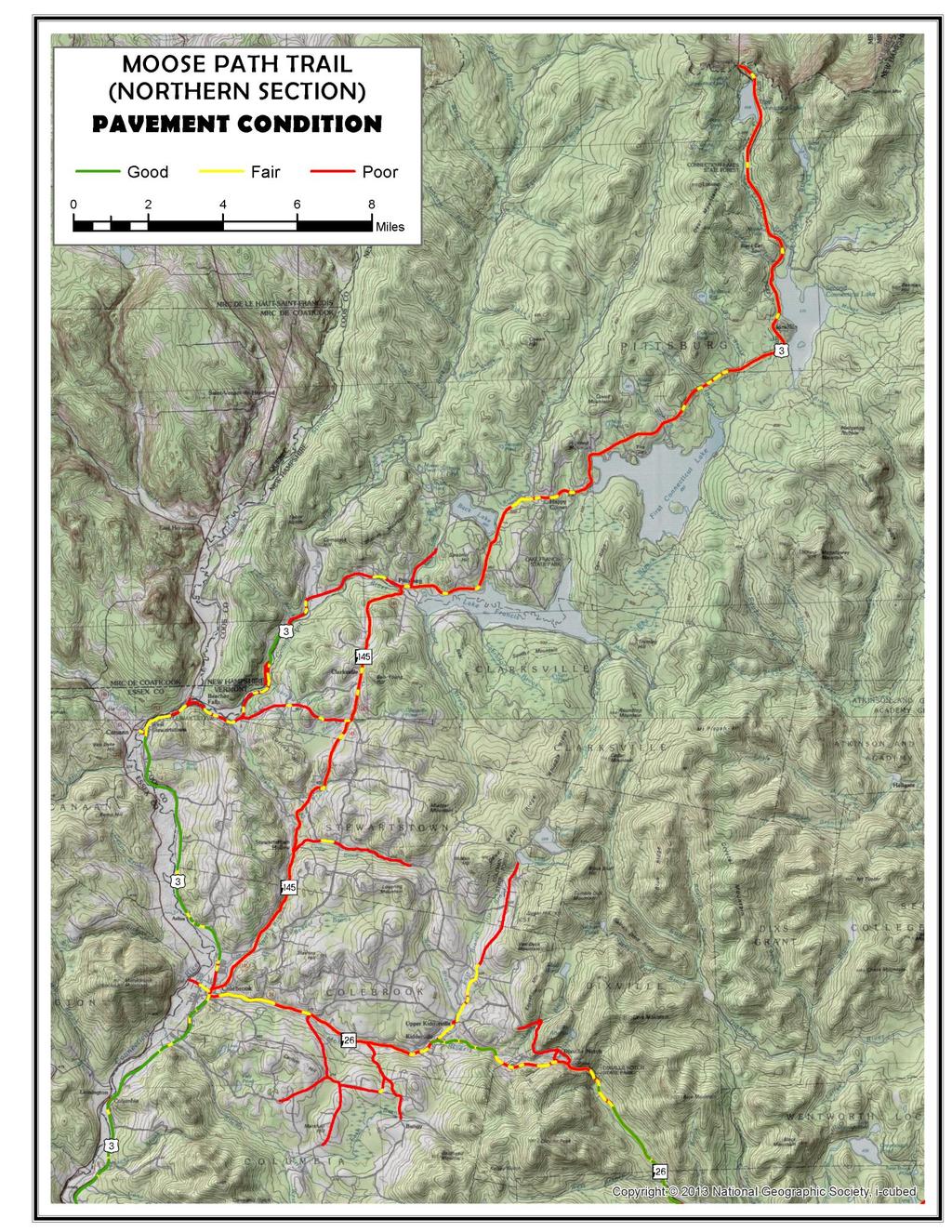
29 Transportation Infrastructure Road Safety The Moose Path Trail has approximately 111 miles of highway in the northern portion of the North Country Region. Data on 1,373 crashes were reported to the New Hampshire Department of Transportation from 2004 to 2013 (see Maps in Appendix C). Almost half (673) involved another vehicle and 18% (254) involved an animal. Almost as many, 245 (18%) involved a median (curb, guardrail, etc.). There were 12 accidents involving fatalities and another 232 involving some kind of injury. Numerous accidents at several locations involved only minor or no injuries. A closer look is needed at the nature and cause of these accidents, e.g., winter driving conditions, drivers unfamiliar with roads, roadway geometry, etc., to identify appropriate mitigation if there are locations with accident rates disproportionate to traffic volumes. Road Condition NHDOT pavement condition data for the byway and selected adjoining roads are shown on the maps on the following pages. Two of the worst segments are NH 16 through downtown Berlin and NH 145. Downtown Berlin is Urban Compact, meaning the municipality is responsible for maintenance; 80% federal funding is sometimes available through NHDOT. Poor drainage has contributed to the deterioration of NH 145. As shown in these pictures, the lack of ditching is causing soil from the shoulders to wash into and down the road, and water to puddle up on the roadway. This is occurring in many locations along NH 145, causing unsafe conditions during and after rain events. 26
30 27
31 28
32 The Moose Path Trail suffers from the typical wintertime pothole and splitting. This natural and cyclical erosion of the Moose Path Trail s roads is a constant concern for the North Country Scenic Byways Council and municipalities. NHDOT maintains a regular program of resurfacing and improvement. When roadways are reconstructed, opportunities to improve pedestrian/bicyclist safety should be considered. For example, shoulders should be wide enough for a bicyclist to be out of the vehicular traffic, but not so wide that they encourage drivers to travel at excess speeds. For major improvements or replacement projects, NHDOT, municipalities, and North Country Council work together to identify and prioritize needs. The resulting Transportation Improvement Program for the region feeds into the state s Ten Year Plan (TYP) for funding. Portions of NH 116 in Dummer, Cambridge and Errol are slated for rehabilitation and widening over the next two years. Other priorities on the Moose Path Trail that were identified as priorities by NCC s Transportation Advisory Committee in its 2015 Update to the Regional Transportation Plan included the bridge in Errol carrying NH 16 over the Moose Pond Outlet, Bridge 147/068 carrying NH 26 over the Mohawk River, several Red Listed bridges, and NH 3 through downtown Colebrook. In March 2015 NHDOT adopted a Pavement Strategy to ensure that a systematic process is followed for prioritizing road improvements. The strategy is based on a system of four tiers. Each is listed below with the corresponding Moose Path Trail segment: Tier 1 Interstates, Turnpikes & Divided Highways - None on Moose Path Trail Tier 2 Major corridors - US 2, US 3, NH 16 except Berlin Urban Compact, NH 26 Tier 3 Collectors - None on Moose Path Trail Tier 4 Secondary highways and unnumbered routes - NH 145 (Source: NHDOT Pavement Strategy - Summary, March 2015) The Strategy calls for prioritizing investment based on those priorities as follows: Pavement Strategies Tier 1 Tier 2 Tier 3 Tier 4 Preservation High High Moderate Moderate Rehabilitation High Low Low Low Reconstruction Maintenance Paving - Moderate Moderate Moderate (Source: NHDOT Pavement Strategy - Summary, March 2015) 29
33 Traffic Volumes As shown in the traffic volume trend data below (Table 4), volumes are not increasing significantly on any of the Moose Path Trail highway segments. Some isolated shifts have occurred as a result of changes in local employment and recreation destinations. Congestion is not a concern on any highway segments on this byway. Isolated local congestion sometimes occurs during special events or busy tourism weekends. Table 4 - Traffic Volume Trends (AADT) Location Gorham - US 2/NH 16 east of Dublin Street Gorham - NH 16 (Main St.) North of US Gorham - NH 16 (Main St.) South of Berlin town line Berlin - NH 16 (Glen Ave.) South of Pleasant St Berlin - NH 16 (Main St.) northbound over Dead River Berlin - NH 16 (Pleasant St.) southbound over Dead River Berlin - NH 16 (Main St.) North of Pleasant St Berlin - NH 16 (Main St.) North of Maple St Berlin- NH 16 (Main St.) North of 10th St Berlin - NH 16 (Main St.) North of Woodward St Berlin - NH 16 at Milan town line Dummer - NH 16 (Milan Rd.) at Milan town line Dummer - NH 16 North of NH 110A Errol - NH 16 (Berlin Rd.) at Cambridge town line Errol - NH 16 North of NH
34 Location Errol - NH 16 at Wentworth s Location town line 650 Wentworth s Location - NH 16 at Maine state line Errol - NH 26 (Upton Rd.) at Cambridge town line Errol - NH 26 (Upton Rd.) over Androscoggin River Errol - NH 26 at Millsfield town line Colebrook - NH 26 (Mohawk Rd.) at Dixville town line Colebrook - NH 26 (Mohawk Rd.) West of Bungy Rd Colebrook - NH 26 (Mohawk Rd.) West of Fish Hatchery Rd Colebrook - US 3 (Main St.) North of Titus Hill Rd Colebrook - US 3 (Main St.) South of Bridge Street Colebrook - NH 145 (Park St.) West of Maple St Colebrook - NH 145 (Park St.) at Stewartstown town line Stewartstown - NH 145 (Hollow Rd.) South of Bishop Brook Rd Clarksville - NH 145 North of Wiswell Rd Pittsburg - NH 145 (Mill St.) at Clarksville town line Pittsburg - US 3 (Daniel Webster Highway) South of Hill Rd Pittsburg - US 3 (Daniel Webster Highway) South of Canadian Border


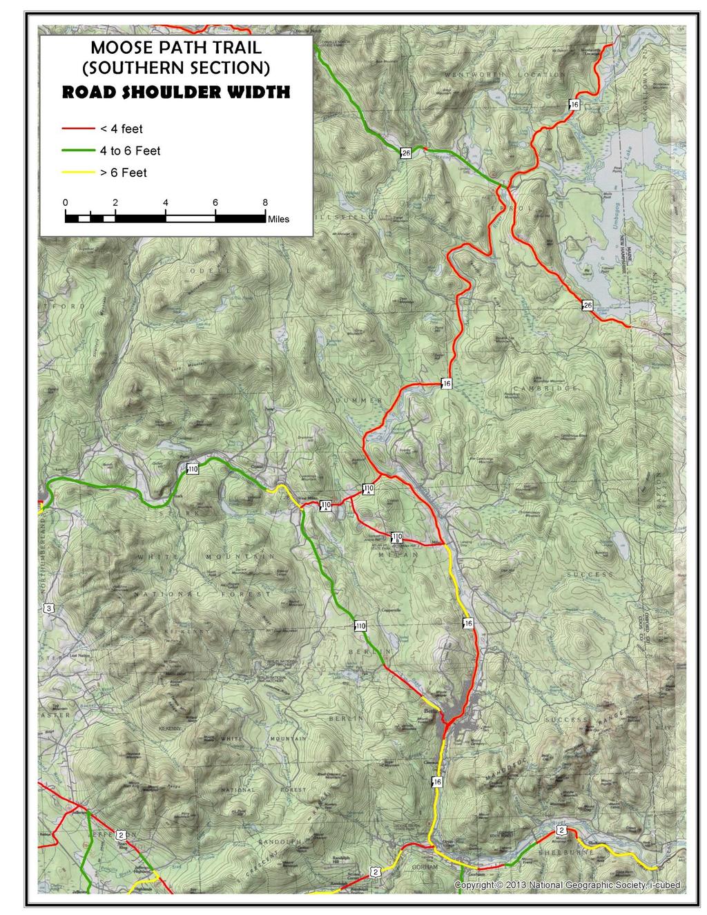
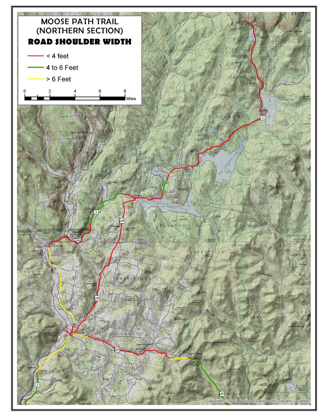
35 Bicycle and Pedestrian Safety A detailed inventory and analysis of the byway segments relative to bicycle safety is needed. Implementation should include a combination of improvements and outreach to the public on the level of experience for which various segments are best suited. Paved shoulders of 4 feet (5 feet when gutters or curbs are present) are recommended for bicycle safety in most circumstances (AASHTO). The NHDOT data on current shoulder widths on the Moose Path Trail and selected adjoining highway segments are shown on the maps on the following pages. The downtowns and larger villages on the Moose Path all have sidewalks and crosswalks. However, the crosswalk markings are almost all so worn off they are virtually nonexistent. A cost effective more durable approach is needed. One particular pedestrian crossing of concern is found in Berlin where the Brown House Museum/Northern Forest Heritage Park Visitor Center and gift shop is on the west side of NH 16 and Northern Heritage Park Gate C is on the east side of NH 16. Signage is needed to warn drivers of the pedestrian crossing at this location, as well as upkeep of the existing crosswalk. 32
36 33
37 34
38 Moose Path Trail Implementation Strategy Development of the North Country Scenic Byways Council s goals and implementation strategies for the Moose Path Trail was a shared effort between municipalities, North Country Council, state agencies, business groups, residents and other stakeholders. Goals and implementation strategies were developed after a thorough examination of byway resources, North Country Scenic Byways Council resources, local plans and regulations, community input, and best practices for scenic byways. Implementation of the plan will further local and regional goals of economic development; protection of natural, cultural, historic, recreational and scenic resources; and rural and community character. Committed and continued follow-up by the surrounding communities and the other participants in the North Country Scenic Byways Council will be required to ensure long- term stewardship of these intrinsic qualities of the byway. Strengthen the Moose Path Theme - Goal 1 Additional byway signs, and either changing to signs with a bywayspecific symbol or adding Moose Path to the state signs, will increase recognition of the byway by residents as well as provide guidance to visitors. A symbol could be used to link signage with other bywayrelated materials and could be displayed by businesses sponsoring the byway. The North Country Scenic Byway Council has formed a committee to explore the costs, possible funding sources, and other issues associated with each approach to customizing and increasing signage. As discussed earlier, the North Country Scenic Byways Council proposes that US 2 from the junction of US 2/NH 16 by the Gorham green to the Maine state line and US 3 from Colebrook to Pittsburg be removed from Moose Path Trail. Establishing the route described herein as the Moose Path Trail will only require the NH Scenic & Cultural Byways Council to relabel these two segments. No change in byway status, e.g. designation or dedesignation, is proposed for any segment. The Moose Path theme would also be strengthened by presenting consistent information on wildlife-related assets and opportunities throughout this byway. This could be accomplished through additional wildlife-themed kiosks, addition of a wildlife theme to existing kiosks and information booths, and an accompanying brochure and on-line tool. The Colebrook visitors center with its Conte refuge displays should be reopened year-round and made the focal point of the Moose Path Trail. Ensure that Communities Remain Engaged - Goal 2 As discussed earlier, to retain state scenic byway designation, it is necessary for each community to continue to have representation on the North Country Scenic Byways Council. Maintaining a high level of community engagement must be the highest priority of the North Country Scenic Byways Council. A Board Development/Membership Committee should be established to lead this activity. Preservation & Enhancement of Resources - Goal 3 The Moose Path Trail makes its way through nine different communities and four Unincorporated Places, each with similar goals. However, they vary in their approaches to managing growth and development 35
39 consistent with local values. Some communities have detailed zoning ordinances; some have no zoning; others have only very basic regulations. Regardless of the way a community chooses to manage its land use, it is important that all of these communities work together to ensure that the state requirements continue to be met for the Moose Path Trail to remain in the byway program; doing so will further economic, resource protection, and other local goals. A Stewardship Committee should be formed to lead this activity. The North Country Scenic Byways Council provides a mechanism for communities to continue to identify cultural, historic, natural, scenic and recreational resources, and seek opportunities for funding projects to enhance enjoyment of identified locations along the Moose Path Trail. To make this effective, a centralized database of the byway s historic and conservation information should be maintained by the Council. As it stands, historic and conservation information is scattered and difficult to track down. Where communities have local inventories these could be linked to the byway database. As the keepers of a centralized database, the Council could in turn provide assistance to conservation commissions, historical societies and others working toward similar goals. The White Mountain National Forest will be an important partner in this effort as well. Although the NHDOT and other state agencies do not currently have scenic byway-specific funding, there may be opportunities in the future- --the North Country Scenic Byways Council should make itself aware of any funding changes. The North Country Council can be a partner in this respect, working with the North Country Scenic Byways Council to identify public and private funding opportunities as they become available, and also include identified projects in regional plans to provide a platform for regional and state input into these byway opportunities. State regulations govern the placement of signs in the state highway right-of-way and contain some specific provisions pertaining to offpremises signs on designated Scenic Byways. In addition, some communities contain standards for signs in their local zoning ordinances. However, there are many communities along the Moose Path Trail that do not have sign regulations that mirror the state requirements. This causes confusion for business owners and enforcement difficulties. It is important that communities be encouraged to review and, where appropriate, strengthen local sign ordinances. In addition, lighting regulations should be reviewed to ensure that outside lighting does not interfere with the vision of the driver on the byway or with the enjoyment of the North Country s dark night sky. There are many historic and scenic resources and recreational opportunities along the Moose Path Trail. These resources are managed by local, state and federal agencies, private landowners, and conservation groups. Facilitating partnerships among these groups will need to be a priority. The North Country Scenic Byways Council and local communities will need to work with the responsible agencies and organizations to ensure that recreation and enjoyment of scenic resources along the byway continues into the future. Transportation & Safety - Goals 4 and 5 The Moose Path Trail covers approximately 111 miles of federal and state highway across the northern portion of the North Country Region. With input from the communities, the North Country Scenic Byways Council and NCC and its Transportation Advisory Committee should work together to bring attention to sections of the Moose Path Trail that are in need of improvement to increase safety or to facilitate safer or increased alternative transportation modes. NCC is also a source of assistance for communities interested in learning more about access 36
River Heritage Trail Corridor Management Plan. North Country Scenic Byways Council
 River Heritage Trail Corridor Management Plan North Country Scenic Byways Council 0 Adopted April 23, 2015 Table of Contents Introduction. 2 The Trail.. 5 Support.... 7 Existing Conditions. 9 Table 1.
City of Durango 5.8 FUNDING TRAILS DEVELOPMENT
 5.8 FUNDING TRAILS DEVELOPMENT The City has been successful in establishing dedicated local funding sources as well as applying for grants to develop the City s trail system, having received nearly $2.4
Androscoggin River Trail Access Sites. North Woods. 168 miles from its source at Lake Umbagog to Merrymeeting Bay
 Androscoggin River Trail Access Sites North Woods 168 miles from its source at Lake Umbagog to Merrymeeting Bay Trail Under Construction More than 40 Public Access Sites Available Androscoggin River Watershed
Proposal to Redevelop Lower Kananaskis River-Barrier Lake. Bow Valley Provincial Park
 Frequently Asked Questions Proposal to Redevelop Lower Kananaskis River-Barrier Lake Bow Valley Provincial Park Frequently Asked Questions What has been decided? What are the details of the plan? What
The Vision for the San Juan Islands Scenic Byway
 The Vision for the San Juan Islands Scenic Byway 2 Judd Cove, Orcas Island, Courtesy of Kurt Thorson (kurtthorson.com) and San Juan County Land Bank Vision for the San Juan Islands Scenic Byway The San
Proposal to Redevelop Lower Kananaskis River-Barrier Lake. Bow Valley Provincial Park. Frequently Asked Questions
 Proposal to Redevelop Lower Kananaskis River-Barrier Lake Bow Valley Provincial Park Frequently Asked Questions What is being proposed? What are the details of the proposal? Where is the project area located?
AGENDA ITEM 5 D WAKULLA ENVIRONMENTAL INSTITUTE (WEI) TRAIL FEASIBILITY STUDY
 TRAIL FEASIBILITY STUDY") March 19, 2018 AGENDA ITEM 5 D WAKULLA ENVIRONMENTAL INSTITUTE (WEI) TRAIL FEASIBILITY STUDY TYPE OF ITEM: Action STATEMENT OF ISSUE The Wakulla Environmental Institute (WEI) Trail is one of several trails
March 19, 2018 AGENDA ITEM 5 D WAKULLA ENVIRONMENTAL INSTITUTE (WEI) TRAIL FEASIBILITY STUDY TYPE OF ITEM: Action STATEMENT OF ISSUE The Wakulla Environmental Institute (WEI) Trail is one of several trails
Longmont to Boulder Regional Trail Jay Road Connection DRAFT FINAL REPORT
 Longmont to Boulder Regional Trail Jay Road Connection DRAFT FINAL REPORT December 2018 Project Summary Boulder County, Colorado, in partnership with the City of Boulder, is evaluating options for multi-use
CHAPTER 5. Chapter 5 Recreation Element
 CHAPTER 5 Recreation Element Chapter 5 Recreation Element The Recreation Element of the Meyers Area Plan is a supplement to the Recreation Element of the TRPA Regional Plan and the El Dorado County General
Non-Motorized Transportation
 Non-Motorized Transportation Non-motorized facilities are important components to the transportation system. They provide an environmentally-friendly, low-cost mode of travel. Some of the facilities can
Chapter 6: POLICY AND PROCEDURE RECOMMENDATIONS
 Chapter 6 POLICY AND PROCEDURE RECOMMENDATIONS FOR SRRA Below are seven policy elements that should be considered for adoption by the Southwest Regional Recreation Authority of Virginia: 1. Develop strategies
Other Principle Arterials Minor Arterial Major Collector Minor Collector Local
 CHAPTER 10 TRANSPORTATION Introduction The system of public roads in East Pikeland Township is decidedly rural in character. Since the 1984, the road network has remained much the same, with the addition
Blueways: Rivers, lakes, or streams with public access for recreation that includes fishing, nature observation, and opportunities for boating.
 Parks, Open Space and Trails PRINCE WILLIAM COUNTY 2008 COMPREHENSIVE PLAN TRAILS PLAN CONTENTS The components of the trails plan are: Intent Definitions Goals, Policies, and Action Strategies Trails Map
Regional Wayfinding Sign Strategy Thurston County Trails 2017
 Regional Wayfinding Sign Strategy Thurston County Trails 2017 Partners: Members and partnering organizations of the Thurston Thrives Community Design Action Team City of Lacey, City of Olympia, City of
Segment 2: La Crescent to Miller s Corner
 goal of the USFWS refuges is to conserve, protect and enhance fish, wildlife and plants and their habitats for the continuing benefit of the American people. Refuge lands are used largely for fishing,
Georgetown-Lewes Rail/Trail Study. Rail/Trail Study: Cool Spring to Cape Henlopen State Park New Road Extension (House Resolution No.
 Georgetown-Lewes Rail/Trail Study Rail/Trail Study: Cool Spring to Cape Henlopen State Park New Road Extension (House Resolution No. 47) August 22, 2011 Presentation Outline Background Benefits Statewide
Welcome to the future of Terwillegar Park a Unique Natural Park
 Welcome to the future of Terwillegar Park a Unique Natural Park 1 Introduction The Terwillegar Park Concept Plan study will develop an overall concept plan, management objectives and development guidelines
Preferred Recreation Recommendations Stemilt-Squilchuck Recreation Plan March 2018
 Preferred Recreation Recommendations Stemilt-Squilchuck Recreation Plan March 2018 Below are the recommended recreation ideas and strategies that package together the various recreation concepts compiled
Business Item No
 Metropolitan Parks and Open Space Commission Meeting date: February 6, 2018 For the Community Development Committee meeting of February 20, 2018 For the Metropolitan Council meeting of February 28, 2018
The Future of the Road to Revolutions. A Battle Road Scenic Byway Public Forum November 9, 2010
 The Future of the Road to Revolutions A Battle Road Scenic Byway Public Forum November 9, 2010 Who is the Battle Road Scenic Byway? Four Towns: Arlington, Lexington, Lincoln, Concord Minute Man National
2. Goals and Policies. The following are the adopted Parks and Trails Goals for Stillwater Township:
 D. PARKS AND TRAILS 1. Introduction Stillwater Township s population is relatively low, with most residents living on rural residences on large lots. The need for active park space has been minimal in
CHAPTER 4 -- THE LAND USE PLAN: DESCRIPTIONS AND POLICIES FOR THIRTEEN PLANNING AREAS
 CHAPTER 4 -- THE LAND USE PLAN: DESCRIPTIONS AND POLICIES FOR THIRTEEN PLANNING AREAS NORTH CENTRAL CAC AREA LITTLE VALLEY ROAD TO JUG HANDLE CREEK PLANNING AREA This planning area includes Cleone, Noyo,
MEETING MINUTES District 1 Trail Planning Meeting 1
 MEETING MINUTES District 1 Trail Planning Meeting 1 June 1, 2017 2:00 PM 3:30 PM City of Two Harbors 2:00 Introductions Attendees: Lisa Austin, MnDOT Bryan Anderson, MnDOT Jasna Hadzic-Stanek, MnDOT Justin
Auburn Trail / Ontario Pathways Trail Connector Feasibility Study Public Information Meeting Wednesday, August 22, 2012
 Auburn Trail / Ontario Pathways Trail Connector Feasibility Study Public Information Meeting Wednesday, August 22, 2012 Purpose of Feasibility Study Purpose Evaluate the feasibility of constructing a multiuse
University Region Non-Motorized Plan 2015
 Non-Motorized Transportation Non-motorized facilities are important components to the transportation system. They provide an environmentally-friendly, low-cost mode of travel. Some of the facilities can
TOURISM & PUBLIC SERVICES RURAL SIGNAGE POLICY
 Policy and Procedures Subject Title: Tourism and Public Services Rural Signage Policy Corporate Policy (Approved by Council): X Policy Ref. No.: ROADS-01-07 Administrative Policy (Approved by CAO): By-Law
MASTER PLAN EXECUTIVE SUMMARY
 Biscuit Run State Park Scottsville Road (State Route 20) Charlottesville, VA 22902 Biscuit Run State Park MASTER PLAN EXECUTIVE SUMMARY Department of Conservation and Recreation Division of Planning and
Yard Creek Provincial Park. Management Plan
 Yard Creek Provincial Park Management Plan Draft January 2010 Yard Creek Provincial Park Management Plan Approved by: telàlsemkin/siyam/chief Scott Benton Bill Williams Squamish Executive Director ation
Item No Halifax Regional Council April 10, 2018
 P.O. Box 1749 Halifax, Nova Scotia B3J 3A5 Canada Item No. 14.3.2 Halifax Regional Council April 10, 2018 TO: SUBMITTED BY: Mayor Savage and Members of Halifax Regional Council Original Signed Councillor
MANAGEMENT DIRECTION STATEMENT June, 1999
 Thompson River District MANAGEMENT DIRECTION STATEMENT June, 1999 for Roche Lake Provincial Park Ministry of Environment Lands and Parks BC Parks Division Table of Contents I. Introduction A. Setting
ROYAL GORGE PARK and RECREATION AREA. A Feat of Natural and Man-Made Engineering
 ROYAL GORGE PARK and RECREATION AREA A Feat of Natural and Man-Made Engineering As Growth Resumed in the 1870 s Town Leaders Began to Envision a Tourist Industry. The Arkansas River Canyon was advertised
Business Item No XXX. Proposed Action That the Metropolitan Council approve the Coon Creek Regional Trail Master Plan.
 Business Item No. 2015-XXX Metropolitan Parks and Open Space Commission Meeting date: July 7, 2015 For the Community Development Committee meeting of July 20, 2015 For the Metropolitan Council meeting
CHAPTER FIVE PROSPECTS FOR FUTURE ECONOMIC DEVELOPMENT
 CHAPTER FIVE PROSPECTS FOR FUTURE ECONOMIC DEVELOPMENT 5.1 GENERAL The recommended type and location of future land uses in Alpine should, in part, consider potential opportunities for future economic
COASTAL CONSERVANCY. Staff Recommendation December 2, 2004 COYOTE HELLYER COUNTY PARK BAY AREA RIDGE TRAIL
 COASTAL CONSERVANCY Staff Recommendation December 2, 2004 COYOTE HELLYER COUNTY PARK BAY AREA RIDGE TRAIL File No. 04-057 Project Manager: Amy Hutzel RECOMMENDED ACTION: Authorization to disburse up to
Strengthening the Ontario Trails Strategy. Report on Consultations and the Environmental Bill of Rights Registry
 Strengthening the Ontario Trails Strategy Report on Consultations and the Environmental Bill of Rights Registry Purpose To report on the feedback and information received through the regional consultations,
Procedure for the Use of Power-Driven Mobility Devices on Mass Audubon Sanctuaries 1 September 17, 2012
 Procedure for the Use of Power-Driven Mobility Devices on Mass Audubon Sanctuaries 1 September 17, 2012 Background As part of Mass Audubon s mission to preserve the nature of Massachusetts for people and
Logo Department Name Agency Organization Organization Address Information 5700 North Sabino Canyon Road
 Logo Department Name Agency Organization Organization Address Information United States Forest Coronado National Forest 5700 North Sabino Canyon Road Department of Service Santa Catalina Ranger District
PROUDLY BRINGING YOU CANADA AT ITS BEST. Management Planning Program NEWSLETTER #1 OCTOBER, 2000
 PROUDLY BRINGING YOU CANADA AT ITS BEST VUNTUT NATIONAL PARK Management Planning Program NEWSLETTER #1 OCTOBER, 2000 INTRODUCTION This newsletter launches the development of the first management plan for
COUNTY COMPREHENSIVE PLAN
 50 : Policy Statement Lewis County has a unique and attractive rural character, which makes it a wonderful place to visit and explore. The region abounds with recreation opportunities that attract visitors
Wilds. Headwaters. Lakes. Oxbows. Falls
 56 5 4 3 Wilds Headwaters Lakes Oxbows Falls 57 Zones It could be said the on-the-ground essence of this master plan appears within the next 6 pages of this report. As we learned in the preceding Cultural
13.1 REGIONAL TOURISM ISSUES AND SUMMARY OF FINDINGS
 13 REGIONAL TOURISM T he County of Mariposa s recreation needs and facilities fall within two categories: regional tourism and local recreation. This Element focuses on regional tourism issues related
GOALS, OBJECTIVES, & RECOMMENDATIONS historic preservation. BUDA 2030 COMPREHENSIVE PLAN preserving our heritage sustaining our future
 HISTORIC PRESERVATION Buda has the second largest concentration of historic structures in Hays County, many of which are located along Main Street in downtown Buda. 1 These historic buildings form the
FINAL TESTIMONY 1 COMMITTEE ON RESOURCES UNITED STATES HOUSE OF REPRESENTATIVES. July 13, 2005 CONCERNING. Motorized Recreational Use of Federal Lands
 FINAL TESTIMONY 1 STATEMENT OF DALE BOSWORTH CHIEF Of the FOREST SERVICE UNITED STATES DEPARTMENT OF AGRICULTURE Before the SUBCOMMITTEE ON FORESTS AND FOREST HEALTH And the SUBCOMMITTEE ON NATIONAL PARKS,
Gardner: overview. Santa Fe, Oregon, and California National Historic Trails UNINCORPORATED JOHNSON COUNTY OLATHE UNINCORPORATED JOHNSON COUNTY
 Santa Fe, Oregon, and California ational Historic Trails : overview 99: p.134 100: p.135 GARDER JUCTIO 102: p.137 56: p.126 EDGERTO Burlington orthern Intermodal and Logistics 98: p.133 101: p.136 S Waverly
Rogue River Access and Management Plan Draft Alternatives
 Rogue River Access and Management Plan Draft Alternatives The Rogue River Access and Management Plan was initiated in December, 2011 and is being led by Jackson County Parks (JCP) and Oregon Department
Establishing a National Urban Park in the Rouge Valley
 STAFF REPORT ACTION REQUIRED Establishing a National Urban Park in the Rouge Valley Date: March 29, 2012 To: From: Wards: Reference Number: Executive Committee Deputy City Manager, Cluster B All p:\2012\cluster
4.0 Context for the Crossing Project
 4.0 Context for the Crossing Project This section provides background information about key features of the North Douglas Crossing project area, and opportunities and constraints. This information is important
chapter - Hex Highway Touring Route Hamburg to Strausstown Overview
 chapter - 2 Hex Highway Touring Route Hamburg to Strausstown Overview The on-road Hex Highway automobile and bicycle touring route begins on State Street in downtown Hamburg. The route continues west on
Land Management Summary
 photo credit: ANGAIR Anglesea Heath Land Management Summary The Anglesea Heath (6,501 ha) was incorporated into the Great Otway National Park in January 2018. This provides an opportunity to consider the
DRAFT GENERAL IMPLEMENTATION PLAN AND SPECIFIC IMPLEMENTATION PLAN MIDDLETON MUNICIPAL AIRPORT MOREY FIELD. Revised 12/12/03
 DRAFT GENERAL IMPLEMENTATION PLAN AND SPECIFIC IMPLEMENTATION PLAN MIDDLETON MUNICIPAL AIRPORT MOREY FIELD Revised 12/12/03 As recommended for approval by the Plan Commission General Project Description
Citrus Heights Creek Corridor Trail Project Trail Advisory Group Field Trip #2 September 11, :00 11:00 am Trellis Hall, Citrus Heights
 September 11, 2013 9:00 11:00 am Trellis Hall, Citrus Heights Project Overview The City of Citrus Heights is studying the feasibility of establishing a multi use trail system within the City s 26 miles
A CASE FOR COMPLETING THE JORDAN RIVER PARKWAY: A
 A CASE FOR COMPLETING THE JORDAN RIVER PARKWAY: A safe crossing at 9000 South and 850 West Proposed 9000 South Underpass Parkway Timeline Parkway, Trail, and Tourism Facts Blueprint Jordan River 1971 1973
Lake Myra County Park. Wake County, North Carolina Community Forum #2 June 12, 2008
 Lake Myra County Park Wake County, North Carolina Community Forum #2 June 12, 2008 Welcome and Introduction Meeting Agenda Welcome Introductions of Project Team Master Plan Process Community Forum #1 Updates
APPENDIX OFFICIAL MAP ORDINANCE OF HAMILTONBAN TOWNSHIP OFFICIAL MAP NARRATIVE
 APPENDIX A OFFICIAL MAP ORDINANCE OF HAMILTONBAN TOWNSHIP OFFICIAL MAP NARRATIVE INTRODUCTION: The Official Map of Hamiltonban Township has been prepared to identify those lands and features that Hamiltonban
Economic Development and Tourism
 SECTION 4 SECTION 4 Economic Development and Tourism 4. Economic Development and Tourism Tourism plays a very important role in Niagara s economy, providing employment and generating business for support
Pillar Park. Management Plan
 Pillar Park Management Plan January 2014 Pillar Park Management Plan Approved by: Jeff Leahy Regional Director Thompson Cariboo Region BC Parks January 9, 2014 Date Brian Bawtinheimer Executive Director
As outlined in the Tatshenshini-Alsek Park Management Agreement, park management will:
 Management Strategy General Strategy The priority management focus for the park is to ensure that its internationally significant natural, cultural heritage and recreational values are protected and that
MPRB: Southwest LRT Community Advisory Committee Issues and Outcomes by Location Current to: 12 November 2010
 MPRB: Southwest LRT Community Advisory Committee Issues and Outcomes by Location Current to: 12 November 2010 This is a compilation of issues and outcomes identified by the CAC. It is a work in progress,
Chambers of Commerce and Lake Groups advertised this NCWRPC created online survey that was : Opened: August 22, 2012; and Closed: October 4, 2012.
 Vilas County Outdoor Recreation Survey Chambers of Commerce and Lake Groups advertised this NCWRPC created online survey that was : Opened: August 22, 202; and Closed: October 4, 202. Q What Vilas County
SUMMER VILLAGE OF SILVER SANDS. Municipal Development Plan
 SUMMER VILLAGE OF SILVER SANDS Municipal Development Plan Bylaw 253-2014 Adopted August 22, 2014 Summer Village of Silver Sands Municipal Development Plan Bylaw No. 253-2014 Page 2 1 INTRODUCTION 1.1 SETTING
2016 Regional Transportation Alternatives Program (TAP) Grant Application
 Grant Application") 2016 Regional Transportation Alternatives Program (TAP) Grant Application PROJECT TITLE: Yelm-Tenino Trail Extension Feasibility Study TRPC use only GENERAL PROJECT INFORMATION Agency or Organization City
2016 Regional Transportation Alternatives Program (TAP) Grant Application PROJECT TITLE: Yelm-Tenino Trail Extension Feasibility Study TRPC use only GENERAL PROJECT INFORMATION Agency or Organization City
Committee Report. Community Development Committee For the Metropolitan Council meeting of August 12, Business Item No.
 Committee Report Business Item No. 2015-168 Community Development Committee For the Metropolitan Council meeting of August 12, 2015 Subject: Coon Creek Regional Trail Master Plan, Anoka County Proposed
Continental Divide National Scenic Trail Legislative History and Planning Guidance
 Continental Divide National Scenic Trail Legislative History and Planning Guidance Legislation, Policy, and Direction Regarding National Scenic Trails The National Trails System Act, P.L. 90-543, was passed
Chapter 2: Summary of Existing Open Space System
 Chapter 2: Summary of Existing Open Space System In 1976, the Wake County Board of Commissioners established the Wake County Parks and Recreation Department in order to provide park facilities and programs
Northeast Quadrant Distinctive Features
 NORTHEAST QUADRANT Northeast Quadrant Distinctive Features LAND USE The Northeast Quadrant includes all the area within the planning area that is east of Interstate 5 and to the north of State Route 44.
Clackamas County Development Agency
 Clackamas County Development Agency Development Services Building, 150 Beavercreek Rd., Oregon City, OR 97045 www.clackamas.us/transportation/renewal 503-742-4323 The Clackamas County Board of Commissioners
System Group Meeting #1. March 2014
 System Group Meeting #1 March 2014 Meeting #1 Outcomes 1. Understand Your Role 2. List of Revisions to Existing Conditions 3. Information Sources Study Area The Purpose of Mountain Accord is to Preserve
J. Recreation Plan of Conservation and Development. The Town of Hebron. Section 2. Preservation of Unique Assets. 1 P a g e
 The Town of Hebron Section 2 2014 Plan of Conservation and Development Preservation of Unique Assets J. Recreation Open spaces, parks, sports fields, and recreational programs are considered essential
Recreation Opportunity Spectrum for River Management v
 Recreation Opportunity Spectrum for Management v. 120803 Introduction The following Recreation Opportunity Spectrum (ROS) characterizations and matrices mirror the presentation in the ROS Primer and Field
4.19 Parks, Recreation, and Conservation Lands
 interchange would have on the Reed Paige Clark Homestead located on the north side of Stonehenge Road. Alternative D would also affect Palmer Homestead, E.F. Adams House, and Knapp Brothers Shoe Manufacturing
PEMBERTON VALLEY RECREATIONAL TRAILS MASTER PLAN UPDATE Community Open House. April 2018
 PEMBERTON VALLEY RECREATIONAL TRAILS MASTER PLAN UPDATE Community Open House April 2018 Introductions Introductions Matt Bakker, BHA Project Coordinator Other Team Members: Liz Scroggins, Grey Owl Consulting
Appalachian Trail Community
 Harpers Ferry, West Virginia Appalachian Trail Community A Designation Program of the Appalachian Trail Conservancy The Appalachian Trail Conservancy (ATC) mission is to preserve and manage the Appalachian
Council Policy Tourist Oriented Destination Signs
 POLICY 373 APPROVED @ City of Kelowna 1435 Water Street Kelowna, BC V1Y 1J4 250 469-8500 kelowna.ca Council Policy Tourist Oriented Destination Signs Contact Department: Civic Operations Traffic Operations
Understanding user expectations And planning for long term sustainability 1
 Understanding user expectations And planning for long term sustainability 1 What is a natural surface trail? It can be as simple has a mineral soil, mulched or graveled pathway, or as developed as elevated
Understanding the caring capacity of the visitor experience Provide facilities to support a high level user experience Address visual quality through
 Understanding the caring capacity of the visitor experience Provide facilities to support a high level user experience Address visual quality through recreation ecological restoration opportunities Collaboration
Welcome to the Cross County Trail Public Input Session!
 Welcome to the Cross County Trail Public Input Session! Please sign in on the table below! What are we doing here? Camden County has proposed a bicycle and pedestrian trail spanning across the entire county.
PURPOSE AND NEED (CONCURRENCE POINT 1) NEW CANADA ROAD PROJECT FROM STATE ROUTE 1 (U.S. HIGHWAY 70) TO U.S. INTERSTATE 40
 NEW CANADA ROAD PROJECT FROM STATE ROUTE 1 (U.S. HIGHWAY 70) TO U.S. INTERSTATE 40") PURPOSE AND NEED (CONCURRENCE POINT 1) NEW CANADA ROAD PROJECT FROM STATE ROUTE 1 (U.S. HIGHWAY 70) TO U.S. INTERSTATE 40 Project Description The primary purpose of this project is to improve the major
PURPOSE AND NEED (CONCURRENCE POINT 1) NEW CANADA ROAD PROJECT FROM STATE ROUTE 1 (U.S. HIGHWAY 70) TO U.S. INTERSTATE 40 Project Description The primary purpose of this project is to improve the major
Dungeness Recreation Area County Park Master Plan
 Dungeness Recreation Area County Park Public Outreach Meeting October 10, 2007 Project Overview USFWS Site Dungeness Recreation Area County Park Meeting Objectives: Re-Introduce project; provide status
This section of the Plan provides a general overview of the Smoky Mountain Region. It consists of the following four subsections:
 SECTION 3 COMMUNITY PROFILE This section of the Plan provides a general overview of the Smoky Mountain Region. It consists of the following four subsections: 3.1 Geography and the Environment 3.2 Population
Rating: 5.0 (scale of 1-10)
") 95 Community Trail System Groundcover: 2-metre paved path, 1- metre grass buffer on either side. Location: Fort St. John Ownership: City of Fort St. John Rating: 5.0 (scale of 1-10) Strategic value: Linear
95 Community Trail System Groundcover: 2-metre paved path, 1- metre grass buffer on either side. Location: Fort St. John Ownership: City of Fort St. John Rating: 5.0 (scale of 1-10) Strategic value: Linear
Section 106 Update Memo #1 Attachment D. Traffic Diversion & APE Expansion Methodology & Maps
 Section 106 Update Memo #1 Attachment D Traffic Diversion & APE Expansion Methodology & Maps I-65/I-70 North Split Interchange Reconstruction Project (Des. Nos. 1592385 & 1600808) Traffic Diversion and
$866,000. $1,400,000 Health Benefits $13,156,000 TOTAL ANNUAL DIRECT BENEFITS. $10,890,000 Economic Benefits
 SINGING RIVER TRAIL Trails Create Value + Generate Economic Activity Trails generate economic returns through improved health, safety, and environmental conditions, raise property values, and attract visitors.
China Creek North Park Upgrades and Glen Pump Station. Park Board Committee Meeting Monday, July 10, 2017
 China Creek North Park Upgrades and Glen Pump Station Park Board Committee Meeting Monday, July 10, 2017 Purpose The purpose of this presentation is to: Share the results of the public engagement processes;
ANAGEMENT. LAN November, 1996
 M ANAGEMENT P LAN November, 1996 for Paul Lake Provincial Park Ministry of Environment, Lands and Parks BC Parks Department Paul Lake Provincial Park M ANAGEMENT P LAN Prepared by BC Parks Kamloops Area
Chapter 9 Recreation
 Chapter 9 Chapter 9 1.0 INTRODUCTION The Town of Littleton is within one of New England s most important recreation areas. More than three million people live within 100 miles of the area. Local residents
Chapter eight. Parks and Recreation. Introduction. Crystal Lake Park District
 Chapter eight Parks and Recreation Introduction One of the indicators of quality of life in a city is the parks and recreation system. The City of Crystal Lake is fortunate to have an excellent parks and
The Recreational Trail along Cushing Park road has been a successful addition to the city
 The Recreational Trail along Cushing Park road has been a successful addition to the city Trails TRAILS, PATHS, ROUTES AND CONNECTORS Citizen input pointed to trails, paths, bike routes, and other non-motorized
Implementation Strategy for the Lethbridge Destination Management Organization (LDMO)
") Implementation Strategy for the Lethbridge Destination Management Organization (LDMO) IMPLEMENTATION AND TRANSITION STRATEGY LDMO MANDATE: To establish a destination management organization that provides
Implementation Strategy for the Lethbridge Destination Management Organization (LDMO) IMPLEMENTATION AND TRANSITION STRATEGY LDMO MANDATE: To establish a destination management organization that provides
Clearwater Lake Provincial Park. Draft Management Plan
 Clearwater Lake Provincial Park Draft Management Plan Clearwater Lake Provincial Park Draft Management Plan Table of Contents 1. Introduction... 3 2. Park History... 4 3. Park Attributes... 4 3.1 Location/Access...4
This Passport: Revised October 20, 2017, EAM # Discovering the Trails of Webster, NY
 This Passport: Revised October 20, 2017, EAM #161923 Discovering the Trails of Webster, NY The Town of Webster invites you to explore and experience our diverse outdoor adventures! Here s your opportunity
Silver Lake Park An Environmental Jewel for the Citizens of Prince William County
 Silver Lake Park An Environmental Jewel for the Citizens of Prince William County The Prince William Park Authority Mission Statement states: The Prince William County Park Authority will create quality
Appendix 3. Greenway Design Standards. The Whitemarsh Township Greenway Plan
 Appendix 3 Greenway Design Standards This chapter discusses two design standards for the greenway types discussed above. First, trail design standards are presented together with trailhead facilities and
WASHINGTON STATE PARKS LAND CLASSIFICATION SYSTEM
 WASHINGTON STATE PARKS LAND CLASSIFICATION SYSTEM Administrative Code Establishing Land Classification System WAC 352-16-020 Land classification system. State park areas are of statewide natural, cultural,
NORTHEAST CARLTON COUNTY BICYCLE ROUTE PLAN
 NORTHEAST CARLTON COUNTY BICYCLE ROUTE PLAN 5/31/2014 and St. Louis River Trail Plan Update Produced by the Arrowhead Regional Development Commission (ARDC) in Partnership with the State Health Improvement
4. Safety Concerns Potential Short and Medium-Term Improvements
 NH Route 104 Access Management Study Page 19 4. Safety Concerns Potential Short and Medium-Term Improvements Potential safety improvement strategies are listed by priority based on field observations by
The Baker/Carver Regional Trail is intended to
 Section V Design Guidance The Baker/Carver Regional Trail is intended to safely accommodate 183,000 annual visits, an array of non-motorized uses, a variety of skill levels, and persons with special needs.
National Recreation Trail Application for Designation
 National Recreation Trail Application for Designation Introduction Thank you for your interest in the National Recreation Trail (NRT) program. Completed NRT application packages must be submitted by December
Cascade River State Park Management Plan Amendment
 This document is made available electronically by the Minnesota Legislative Reference Library as part of an ongoing digital archiving project. http://www.leg.state.mn.us/lrl/lrl.asp Cascade River State
CHAPTER 9. PARKS, RECREATION, TRAILS AND NATURAL AREA RESOURCES
 CHAPTER 9. PARKS, RECREATION, TRAILS AND NATURAL AREA RESOURCES The forms of recreation chosen by residents and visitors in the CBJ are as diverse as the population. Many people choose to recreate in developed
White Mountain National Forest Saco Ranger District
 United States Department of Agriculture Forest Service White Mountain National Forest Saco Ranger District 33 Kancamagus Highway Conway, NH 03818 Comm: (603) 447-5448 TTY: (603) 447-3121 File Code: 1950