Stemilt-Squilchuck Recreation Plan DRAFT
|
|
|
- Candace Collins
- 5 years ago
- Views:
Transcription


1 Stemilt-Squilchuck Recreation Plan DRAFT Chelan County Natural Resource Department 2018
2 2
3 Table of Contents Acknowledgments. 5 Executive Summary Chapter 1: Introduction Background. 6 Previous Planning Efforts 6 Scope and Purpose.. 7 Vision and Goals...9 Planning process overview Public Input..12 Chapter 2: Planning Area Landowners and Jurisdiction Planning Zones Chapter 3: Issues and Opportunities...22 Chapter 4: Desired Conditions. 22 Chapter 5: Wildlife Considerations..25 Modeling and Mapping Chapter 6: Discussion of Alternatives Chapter 7: Recommendations Maps Chapter 8: Implementation.. 45 Implementation Framework Roles and Coordination Chapter 9: Monitoring Plan Potential Indicators Related to Key Issues and Opportunities Monitoring Framework Appendices A: Recreation Planning Charter..62 B: Design Drawings C: Public Comment Response..69 D: Potential Funding Sources..72 3
4 E: Evolution of the Winter Recreation Concept...72 F: Naneum Plan/Stemilt Plan Area Overlap Context Map.84 List of Figures Figure 1. Planning Area....9 Figure 2. Planning Process Timeline.. 11 Figure 3. Land Ownership 13 Figure 4. Planning Area Boundary..14 Figure 5. Planning Zones Figure 6. Elk Habitat Potential.. 26 Figure 7. Stemilt Basin Bull Elk Use...28 Figure 8. Stemilt Basin Bull Elk Use During Rut. 29 Figure 9. Summer Recommendations Map...43 Figure 10. Winter Recommendations Map...44 Figure 11. Clear Lake Draft Design Drawing...66 Figure 12. Steffen s Meadow Draft Design Drawing 67 Figure 13. Upper Wheeler Reservior Access Draft Design Drawing..68 Figure 14. Naneum Plan Winter Concept Map Figure 15. El Sendero Original Winter Proposal Map Figure 16. March 2108 Open House Winter Recommendations Map.. 76 Figure 17. Motorized Group Winter Proposal Map.. 77 Figure 18. Compromise Winter Proposal Map Figure 19. All Winter Proposals Map Figure 20. Stemilt Elevation Map with All Winter Proposals
5 Acknowledgments This plan would not have been possible without contributions from the following groups and individuals. The Recreation Planning Committee spent many hours in meetings and following correspondence regarding the planning process. Many members of the planning committee volunteered time for the effort, showing a commendable commitment to the process. This effort was truly a community planning effort, and the participation of these community members was crucial to the process. Technical assistance was provided through the National Park Service Rivers, Trails, and Conservation Assistance (RTCA) program. The RTCA program brought a high level of expertise and organization that was incredibly helpful in undertaking this thorough planning process. Financial assistance was provided through grants from North Central Washington Community Foundation and Our Valley Our Future grant program, supporting staffing needs to facilitate the process. Washington Department of Fish and Wildlife (WDFW), Washington Department of Natural Resources (DNR), Washington State Parks, Mission Ridge, and El Sendero all saw the need for this plan and provided letters of support to enable the process to get underway, and participated consistently in the planning effort. Finally, the Stemilt Partnership and the community at large stayed engaged throughout, and provided input and comments to help shape the outcome of the plan. Executive Summary The upper Stemilt and Squilchuck basins are a focal point for recreation in the Wenatchee Valley and beyond. This planning effort seeks to thoughtfully address the future of recreation in this area, while also recognizing that it is not a blank slate but an area of multiple uses already occurring on the landscape. With all respect to the local residents and families who have been using this area for generations, this is also a time of change in the Wentachee Valley and there is a call for more recreational opportunity to enhance the quality of life for residents and visitors alike. This plan takes a comprehensive look at the existing and potential recreation opportunities in the area and seeks to balance these with wildlife habitat needs, agricultural infrastructure needs, and resource and community protection elements. The intent is not to impose wholesale change in the basin and detract from the appeal of this natural landscape, but rather to focus recreation impacts to protect the values of the Stemilt Partnership and provide a strategy for growth of recreation opportunity that continues to protect these values. As many things are in flux in this 17,000+ acre planning area, this plan should be revisited and updated every 10 years to ensure the goals of the plan are being met. The implementation and monitoring elements of this plan should be reviewed annually to gauge progress and assess adaptive management needs. Additionally, this plan will require continued community participation to move toward implementation and to solve some remaining issues described herein. 5
6 Chapter 1: Introduction Background This plan was written for, and under guidance of, the Stemilt Partnership, in collaboration with Washington Department of Fish and Wildlife and Washington Department of Natural Resources. The Stemilt Partnership was formed in 2007 in response to the proposed sale and privatization of over 2,500 acres of DNR upland forest in the Stemilt Basin. The Partnership, made up of a broad coalition of agriculture, wildlife, recreation, and conservation interests, worked with Chelan County to stop the sale and create a shared vision for managing the landscape. The foundation of the Stemilt Partnership Vision is the protection of water resources, wildlife, and recreation in the Stemilt Basin. In 2012, investment in the Stemilt Vision increased when Chelan County purchased about 2,500 additional acres in the basin from Longview Timberlands Co., with the intent of preventing privatization and development in the basin. The Stemilt Partnership, facilitated by Chelan County Natural Resource Department, meets regularly to discuss management of what is now referred to as the Stemilt-Squilchuck Community Forest. This plan directly addresses one of the three pillars of the Stemilt Vision. Along with water resources and wildlife, recreation is highly valued in the Stemilt and Basin. With pressures from increasing development on private property within the basin, increases in use as the population of the Wenatchee Valley grows and the popularity of outdoor recreation rises, and illegal and damaging activities occurring in the basin, the need for a plan to guide the future of recreation and the protection of resources affected by recreation has become apparent. Previous Planning Efforts In 2015, the Washington Department of Natural Resources and the Washington Department of Fish and Wildlife completed the Naneum Ridge to Columbia River Recreation and Access Plan ( _columbia_river_rec_plan). This joint effort between the state agencies covers a large area including the Colockum and Whiskey Dick Wildlife Areas, part of the Haney Meadows/Tronsen Ridge area, and the Stemilt Basin, which comprises a small percentage of the planning area. The Naneum Plan includes recreational suitability modeling, management goals and strategies, and some recreation development concepts for the Stemilt Basin. While the concepts provide some specific direction, such as a north-south trail linking Squilchuck State Park to Naneum Ridge trails and winter non-motorized access and play areas, these concepts lack the specificity needed to be vetted by the Stemilt Partnership and the community at large. The Stemilt Basin is a unique area with a broad range of stakeholders and interests, and a robust planning effort focusing just on this area and the adjoining access points from the Squilchuck Basin would facilitate implementation of the Naneum concepts pertaining to the Stemilt area. The impetus for this undertaking 6
7 was the need for a focused planning effort that could examine the current conditions, incorporate work done through other planning efforts, take into account the changes on the horizon, and produce a set of recommendations vetted by the Stemilt Partnership, the agencies and landowners, and the community as a whole. The combination of checkerboard land ownership, importance of wildlife and water resources, and an invested local community underscores the importance of developing a recreation plan that is specific to the area and is produced through a collaborative process. The 2008 Stemilt-Squilchuck Community Vision Document ( also offers guidance for recreation planning in the basin. The Vision Document was produced through an effort between Chelan County, the Trust for Public Land, and the Stemilt Partnership in 2007 (Stemilt-Squilchuck Community Vision, 2008). The Vision Document provides good insight on recreational use and potential, and includes a set of potential recreation development concepts and considerations devised by the Stemilt Recreational Technical Subcommittee during the compilation of the Document. The document contains an overview of recreational activity in the basin, along with mapping of known recreation sites and traffic-count numbers tracking vehicle use throughout a calendar year. Wildlife habitat modeling for elk and other priority habitats and species is also included. The document expresses the desire of the Stemilt community to protect traditional recreation opportunities such as hunting, fishing, and snowmobiling, while also protecting the wildlife and water resources in the basin. The Vision Document makes broad vision statements, but lacks specificity on how to accomplish the overall recreation goals for the basin. Protection of water resources and wildlife, two of the three pillars of the Vision Document, play major roles in planning for the third pillar, recreation opportunity in the Stemilt- Squilchuck Community Forest. Scope and Purpose of Plan The purpose of the Stemilt-Squilchuck Recreation Plan is to provide guidance and recommendations for managing recreation in the Stemilt-Squilchuck basin in a manner that provides for the types of recreational opportunity desired by the community while also protecting the important values of wildlife, water, and natural resources. While the Plan is not a formal management plan, it does represent input from local stakeholders on how recreation should be managed in the basin. It is designed to provide a path forward for managing recreation in the area over the next decade. Recommendations in the Plan are strictly voluntary and are not legally binding in any way to the landowners and managers; rather they are meant to provide informed guidance on how lands in the Stemilt- Squilchuck basin can be managed to meet both recreation and conservation goals. The Plan will be a useful tool in articulating a shared vision and recommended actions, and will help facilitate the securing of necessary funding for implementation of the recommended actions. In addition, portions of the plan may be incorporated into other management plans. 7
8 This Plan is a collaborative effort made in good faith, and no funds are currently allocated for implementation. Stakeholders will work collaboratively to identify funding sources and implement plan elements over the next several years, as described in the Implementation section. The actions described within are recommendations vetted through a community planning effort with robust public outreach. The Plan is intended to serve as a guiding document to help landowners, land managers, and stakeholders implement concepts developed through previous planning efforts in a way that preserves the values held by the Stemilt Partnership and the community, as well as address future recreational growth and development in the basin in a thoughtful and collaborative manner. This Plan does not supercede the authority of existing land and water management authorities or plans. Recommendations may be implemented in a phased approach, or by priority of action as funding or opportunity allow. There is no expectation that all elements will be implemented immediately. Adoption of the plan will require environmental review under the State Environmental Policy Act (SEPA), and individual actions moving through the implementation phase will comply with all applicable permitting needs and SEPA requirements. The geographic scope of the Plan includes the various land ownerships in the Upper Stemilt and Squilchuck watersheds. Land ownership is primarily WDFW, DNR, and Chelan County, but also includes United States Forest Service and private lands. While recommendations on County Lands are officially adopted through this Plan, recommendations on state and federal lands are suggestions for future management, and will need to first be vetted through other environmental and legal planning processes before a formal obligation attaches to management. The Plan holds no obligation for private landowners, but collaboration with private landowners has and will likely continue to occur to address plan recommendations. The planning area falls within the scope of the 2016 Naneum Ridge to Columbia River Recreation and Access Plan, and the recommendations in the plan are designed to fit within and compliment those of the Naneum Plan (this Plan may be considered a supplement or addendum to the Naneum Plan). See Appendix F for a context map showing the spatial relationship of the Naneum Plan and the Stemilt-Squilchuck Recreation Plan. 8

9 Figure 1. Planning Area Vision and Goals The vision statement and goals for the planning process were established in November 2016 by the recreation planning committee. The vision statement highlights the importance of including all stakeholders and community values in the process, and also incorporates the three pillars of the Stemilt Vision Document. The goals established early on proved to emerge as important themes throughout the planning process. Vision Statement Establish sustainable recreation opportunities in the Stemilt-Squilchuck Basin through a community based planning process that embraces community values, protection of water and wildlife resources, and collaboration with all stakeholders. Goals established by the Recreation Planning Committee Provide access and infrastructure to enhance recreation opportunity 9
10 Protect wildlife, water, and natural resources Work together with stakeholders, agencies, and all interests Build on the work done through previous planning efforts Improve current land management issues Accommodate current and future needs Provide all members of the community equal access to recreation Identify appropriate areas for activities to reduce conflict (managed recreation and seasonal considerations) Provide a safe and secure environment through law enforcement and fire response Incorporate education and outreach Allow for adaptive management Enhance quality of life in Chelan County Planning Process Overview Chelan County Natural Resource Department (CCNRD) began facilitation of the Stemilt- Squilchuck recreation planning process in May The planning process was initiated by convening a group of local stakeholders representing land managers and recreational interests to gauge interest in working toward a recreation plan for the Stemilt-Squilchuck basin, in response to the completion of the 2015 Naneum Plan and several land use proposals in the watershed. This original group of stakeholders would largely comprise the recreation planning committee that was crucial to the planning process. In January 2017, CCNRD was joined by the National Park Service Rivers, Trails, and Conservation Assistance program through a planning assistance grant. Shortly thereafter, a core stakeholder group including landowners/managers and the Stemilt Partnership Steering Committee convened to establish the Charter and the decision-making process (see Appendix A). Beginning in March 2017, bi-monthly meetings were held with the established recreation planning committee to work on various elements of the Plan. The recreation planning committee had representation from land and resource management agencies, local recreationists (both motorized and non-motorized), private landowner representatives, wildlife specialists, local irrigation districts, Wenatchee Chamber of Commerce, Chelan County government, Wenatchee Valley College, and nonprofit organizations (see Appendix A for complete list of participants). The group met 10 times between May 2016 and July 2018, totaling about 30 hours of planning sessions. New members were added in April 2018 in response to interest and concerns brought forward by community members at the March 2018 Open House. Meetings were open to public and all meeting materials were made available on the Chelan County Natural Resource Department website ( Planning group members also spent time outside of planning sessions reviewing documents, providing input, and attending Stemilt Partnership and Open House meetings. The following timeline provides an outline of the activities that were carried out by the planning group over the 2+ year process. 10


11 Figure 2. Planning Process Timeline 11
12 Research and Inventory Inventory and analysis of existing and potential development sites was an important component of the planning process. Existing sites were visited during the first year of the planning process to determine recreation opportunities and impacts currently present on the landscape. A survey was sent out to the Stemilt Partnership to gather observationbased information from frequent users on types and levels of use of popular recreation areas in the planning area. This survey returned 42 responses and provided a basis for development of site-improvement concept designs for several high-use recreation sites (see Concept Designs, Appendix B). CCNRD and NPS staff also met independently with stakeholders, including pubic land managers, irrigation districts, and private landowners. These meetings helped shape the recommendations by identifying the concerns and opportunities posed by the draft recommendations. Public Input Public input was a critical component of the planning process. Feedback gathered from the Stemilt Partnership and local residents mid-way through the planning process shed light on concerns surrounding public access and land use, and helped to guide development of recommendations that could meet the needs of the greater community. A survey containing the draft recommendations and maps was distributed by to the Stemilt Partnership and local residents in November 2017, prior to finalization of the draft recommendations. The survey received 47 responses, many of which provided specific feedback. The recreation planning group reviewed and incorporated this feedback into the draft recommendations in January During this time, Washington Department of Fish and Wildlife also completed their review of the draft recommendations, and provided written comment. These comments were also incorporated into the draft recommendations in January After review of revisions to the draft recommendations by the planning group, a public Open House was held at the Malaga Fire Hall in March 2018 to share the draft recommendations and gather public comment. A 90-day comment period was open following the Open House, during which over 200 public comments were received, primarily through and letters sent to the Chelan County Natural Resources office. Verbal comments from the March 2018 Open House were also captured and included in the comment compilation. The planning committee reviewed all public comments and worked in subgroups to address major concerns. Public input was incorporated into the plan through revisions to some recommendations and responses to the range of comments. See Appendix C for response to public comment. A comprehensive document of all public comments received can be viewed on the Chelan County Natural Resource Department s Stemilt Partnership page ( 12

13 The draft Stemilt-Squilchuck Recreation Plan was completed and reviewed by the planning group in September 2018, and was reviewed by the Stemilt Partnership and land management agencies in October/November Chapter 2: Planning Area Landowners/Jurisdiction Land ownership in the planning area is split between Washington Department of Fish and Wildlife, Washington Department of Natural Resources, Chelan County, private ownership, United States Forest Service, and Washington State Parks. With a patchwork ownership pattern across the basin, collaboration across agencies and landowners is necessary to meet the shared goals of the Partnership and landowners. Figure 3. Land Ownership 13

14 The Stemilt-Squilchuck watershed is situated to the south of Wenatchee and to the north of Ellensburg in Central Washington, and drains north into the Columbia River. The upper watershed is primarily publicly owned and undeveloped, and through conservation efforts by Chelan County, Trust for Public Land, and the Stemilt Partnership, has gained recognition as the Stemilt Community Forest. The majority of the public lands comprising the area of the proposed recreation plan range from 3,000-6,000 feet above sea level and experience four distinct seasons. The lower reaches of the watershed are primarily privately owned and a mixture of dispersed residential and orchard land, and are not included in the recreation planning area. The planning area is bordered by the Stemilt watershed boundary to the south and east (Naneum Ridge separates the basin from the Colockum basin to the east and the Swift Creek basin to the south), by Mission Ridge Ski Area and Squilchuck Road to the west, and by Stemilt Loop Road to the north. Land ownership is a checkerboard of Washington Department of Fish and Wildlife (WDFW), Washington Department of Natural Resources (DNR), Chelan County, Washington State Parks, and private lands. Figure 4. Planning Area Boundary 14
15 The forested landscape of the upper Stemilt-Squilchuck basin lends itself to a variety of activities including hiking, mountain biking, horseback riding, fishing, hunting and wildlife viewing, skiing and snowshoeing, snowmobiling, and ATV use. Use patterns vary spatially and seasonally in the basin, ranging from summer high use in the lower reaches, to winter motorized recreation in some of the upper reaches, and to relatively little use overall in other areas. Access points and dispersed camping areas in the basin are generally not developed, and in some cases are heavily impacted by illegal off-road driving, litter, and erosion to roads and parking areas. While the local community has expressed interest in developing non-motorized summer and winter recreation opportunities, including hiking, mountain biking, horseback riding, and backcountry skiing and snowshoeing, very few non-motorized trails currently exist in the basin. The goal of the recreation planning project is an integrated recreation plan that accomplishes the twin goals of conservation and enhanced recreation opportunity, while also protecting the values of the local community through outreach and a collaborative planning process. Planning Zones For the purposes of describing the area and initiating a planning strategy, the planning area was divided into zones that exhibit certain characteristics of recreational use and opportunity. These characteristics include use patterns, access, terrain, presence of critical wildlife habitat, and community values. The divisions are based on field observations, WDFW wildlife data, Stemilt Vision Document maps and data, and anecdotal information from local user groups. This map represents a draft of the zone delineation concept, and can be revised as needed. Zone descriptions are accompanied by photos taken in the field by County staff during the 2016 summer/fall season. 15

16 Figure 5. Planning Zones 16
17 Descriptions of Area by Zone Delineation, as of February 2017 Zone 1 Accessed primarily from Stemilt Loop Road. Encompasses Upper Basin Loop Road and associated spur roads, which are part of the Green Dot Road system. These roads provide the main vehicle access into the upper Stemilt basin, and are connected to many other non-green Dot roads that are technically closed to motorized traffic, but are still used illegally by motorized vehicles. Some of these non-green Dot roads do have easements for irrigation facility maintenance requiring access, but others could be closed and/or decommissioned. A roads analysis will be an important component to future management of these roads for resource protection and recreation enhancement. Gets heavy vehicle use in spring, summer, and fall, and snowmobile use (including an extensive groomed snowmobile trail system) in the winter, with fishing, camping, hunting, wildlife viewing, hiking, horseback riding, recreational driving, and snowmobiling being the main recreational activities taking place. Traffic counters installed in 2007 at Green Dot road entrance points into the upper basin show vehicle use increases in the late spring and fall, May being the peak month with 3,073 counts on the Upper Basin Loop Road in May 2007 (Stemilt Vision Document, 2008). Contains the majority of the dispersed campsites in the basin, many of which are heavily used in the fall for hunting camps. Many of the impacted campsites occur near water bodies, and are likely used by anglers as well. Is visibly affected on some areas by illegal off-roading, trash dumping, large bonfires/impacted campsites. Little enforcement of Green Dot Road regulations occurs, although WDFW does occasional patrols in this area. Interest is expressed by WDFW and DNR to improve the Green Dot Road system and find ways to increase compliance. Local residents (and Stemilt Partnership) have expressed interest in more enforcement, barriers on non-green Dot Roads, and restoration projects. Local residents are also protective of traditional recreational activities in this area. Contains private property, WDFW lands, and County lands. Two sections (16 and 22) transitioned from DNR to WDFW ownership in June This zone contains the highest concentration of critical elk habitat as shown on 17


18 WDFW data-derived summer elk habitat map. Recreation planning focus would likely be on enforcing existing road closures with gates or barriers, converting non-green dot roads to non-motorized trails, delineating campsites to reduce dispersed camping impacts, improving access points, and identifying areas for restoration. Public input received regarding recreation in this zone includes better equestrian parking and designated equestrian trails, a winter non-motorized trail system, improvements to fishing regulation, designated campsites, designated motorized and non-motorized trails, and better enforcement of Green Dot Road System. The County is undertaking a meadow restoration project in an area heavily impacted by vehicle use in a wetland/meadow on the Section 29/28 border, which involves rerouting a portion of the current Green Dot road out of the meadow area. The County is also working toward a Forest Management Plan for County lands in the upper basin, which will tie in closely with road and recreation management. Photos of Zone 1 (all photos by Chelan County staff unless otherwise stated): Fishing register at Upper Wheeler Reservoir Meadow damage from vehicles in Steffens Meadow 18

 and Forest Ridge community off")


19 Campsite impacts, Steffens Meadow Dispersed campsite at Lily Lake View of a hidden meadow Clear Lake, Chelan County Section 23 Green Dot road signage at Orr Creek Road Lily Lake access point in spring Zone 2 Main access points are from Squilchuck State Park, Mission Ridge Ski Area, Upper Wheeler Road (in very rough condition) and Forest Ridge community off of Squilchuck Road. Squilchuck State Park has a newly developed mountain bike trail system that does not currently extend into the Stemilt Basin. Mission Ridge Ski Area has purchased Section 19 and the northeast corner of Section 30, and is planning an expansion of ski area operations. It is possible to access the Stemilt basin via non-motorized travel on road systems or 19


20 cross-country from Squilchuck and Mission Ridge, but routes are not well established or signed. Local outdoor enthusiasts have expressed interest in access to non-motorized recreation opportunities in this area. The Nanuem Plan and the Stemilt Vision Document also have recreation concepts around non-motorized trail development in this area. The Nanuem Plan specifies development of a non-motorized trail from Squilchuck State Park linking to a non-motorized trailhead in the Naneum State Forest. The Vision Document shows an area marked out as Potential Recreation Expansion Area in this zone, with a potential new bicycle route marked out near Upper Wheeler Reservior. Most of this area does not fall within the WDFW mapped critical elk habitat, but consultation with wildlife biologists is a high priority for development discussions. Public input received for this area includes non-motorized trail expansion from Squilchuck State Park into Stemilt basin, possibly linking into Mission Ridge property, nordic skiing trail system, snowmobile access from Forest Ridge into Stemilt basin, better access to back-country skiing in Stemilt basin, fat-tire biking trails in Squlchuck State Park. Photos of Zone 2: Upper Wheeler Reservoir, wooded ridge in Sec. 30 Slopes above Squilchuck State Park Zone 3 Characterized by rough roads, difficult access, and little in the way of developed recreation resources, this area is primarily used for hunting, snowmobiling, and OHV use. The Schaller Road connects into the Colockum Wildlife Area and Naneum Ridge State Forest, and can be accessed from Ellensburg to the south. 20


.")

21 Public input on recreation development in this area includes a warming hut on the groomed snowmobile trail and a Green Dot road connector that would make Pole Flat road a loop instead of a dead-end. The 2007 traffic counter found the highest use of Schaller Road was in October (892 counts), likely due to hunting traffic. Land ownership in this area is composed primarily of WDFW and DNR, and lies within the Colockum Wildlife Area. This area primarily sees traditional types of recreation (meaning that the types of use have not significantly changed over time, and are recreational activities that local families are protective of). This may be a good area to consider avoiding further recreational development to avoid user conflicts and protect wildlife and community values. Nanuem Ridge from Schaller Road Upper reaches of Stemilt basin, from Section 29 Snowmobilers atop Naneum Ridge Skier in Upper basin, photo: WenatcheeOutdoors.com 21
22 Photo: applecountrysnowmobileclub.com Chapter 3: Issues and Opportunities The following issues and opportunities were identified by an initial steering committee in January The initial steering committee was composed of members of the Stemilt Partnership, landowners, and key recreation stakeholders. This list identifies both things that are occurring in the area with undesired impacts as a result, and things that could occur and produce desired results. Intentional and unintentional motorized use of the non-green dot road system due to lack of information and management. Intentional and unintentional recreation use of private lands. Impacts of current and future recreation use on wildlife, water, and natural resources. Perceived changes in types and amounts of recreational use. Potential conflicts between recreation users. Lack of agency personnel resources to conduct adequate backcountry enforcement of illegal recreation uses. Continue to provide opportunities for traditional uses such as hunting, fishing, and snowmobiling. Create desired new types of non-motorized recreation opportunities. Build on partnerships for implementation and management of recreation use. Chapter 4: Desired Conditions Desired conditions are defined as statements of aspiration that describe resource conditions, visitor experiences and opportunities, and facilities that agencies and stakeholders want to achieve and maintain in a particular area. Desired conditions describe what conditions, outcomes, and opportunities are to be achieved and maintained in the future, not necessarily what exists today. Desired conditions paint a picture of what the particular area should look like, feel like, sound like, and function like in the future. The Desired Conditions document for this planning process was developed by the planning committee as an umbrella statement under which all recommendations for each zone should fall. This document served as a checkpoint to ensure that the recommendations developed by the group were in-line with the overall expectations of user experience, appropriate activities and facilities, and natural resource and wildlife considerations described by zone. The Desired Conditions Document developed by the committee and shared with the Stemilt Partnership is as follows. Desired Conditions for Zone 1: 22
23 Natural Resources: Natural and ecological processes may be controlled to protect human life and infrastructure. Forests away from roadways provide sufficient diversity of age and understory for wildlife health. Agricultural water supply is protected and the basin s stream and wetland system is largely intact just off roadways. Impacts and modifications of the landscape are found at irrigation/reclamation district sites, designated recreations sites and along designated roads. Visitor Experience: Visitors have better access to short trips and close to home opportunities via limited networks of green dot roads that are clearly marked. Regulations are clearly articulated along roadways and at designated sites for various activities so visitors know how to help care for shared resources and what to expect from other visitors. The presence of other visitors and law enforcement is expected near main roadways during peak season. Opportunities for resource education are available at strategic areas throughout this zone and by working with partner organizations. Activities: This zone includes day and overnight use, with camping in small rustic campgrounds and dispersed primitive camping spots. Appropriate visitor activities include hiking, mountain biking, horseback riding, wildlife viewing, hunting, fishing, snowmobiling, backcountry skiing, cross country skiing, snowshoeing. Appropriate motorized activities on green dot roads and other seasonally designated routes subject to seasonal wildlife closures include vehicle driving (on green dot roads only), motorcycles and ATVs (on designated routes), and snowmobiles outside of winter non-motorized area. Target shooting may occur in Zone 1, but is not appropriate in high-use areas. Facilities: Facilities appropriate in this zone are limited to rustic well-maintained trails, directional and interpretive signs, sanitation facilities, small trailhead parking lots, graded gravel roads and established campsites in high use areas. Facilities primarily center along the Upper Stemilt Loop Road. Established campsites are basic and do not have running water or showers. Some facilities are accessible for visitors with disabilities and these areas are clearly marked. One parking lot and trail can accommodate a small number of horse trailers. Sections 16 and 22 (WDFW) have restrictions on recreational development to prioritize for conservation of critical wildlife habitat under Cooperative Endangered Species Conservation Fund requirements. Desired Conditions for Zone 2: Natural Resources: Natural and ecological processes may be controlled to protect human life and infrastructure. Sensitive hydrological areas, wildlife, and forest health are protected and largely undisturbed just off roadways. Impacts and modifications of the landscape are found at designated recreations sites, irrigation and reclamation district infrastructure, communities, and along designated roads. 23
24 Visitor Experiences: Visitors have better access to more recreational opportunities through creation of designated trail linkages to adjacent partner trails and areas; designated trail linkages are compatible with seasonal wildlife usage. Use is concentrated near communities and developments. Recreation expansion on private lands in Zone 2 leads to higher concentrations of use in these areas and on adjacent public lands. Opportunities for resource education are available at strategic areas throughout this zone and by working with partner organizations. Efforts to strategically combine recreation resources with wildfire protection actions will be incorporated in planning. Activities: This zone includes day use, with group camping available at Squilchuck State Park. Appropriate visitor activities include hiking, mountain biking, horseback riding, wildlife viewing, hunting, fishing, cross country skiing, backcountry skiing, snowshoeing. ATV and snowmobile use are appropriate in this zone only on a designated and agreedupon route for Forest Ridge residents, subject to seasonal wildlife closures, in order to access the Green Dot road system in the summer or groomed snowmobile trails in the winter. Facilities: Facilities in this zone are limited to rustic day use parking areas to accommodate high use trailheads and strategically placed sanitation facilities for trailheads and popular reservoirs. Other appropriate facilities in this zone include primitive trails and signs to clarify routes and uses allowed in higher use areas. Desired Conditions for Zone 3: Natural Resources: Natural and ecological processes predominate. Water resources and wildlife are protected and largely undisturbed. The landscape is generally undeveloped, with the exception of green dot roads. Areas of Zone 3 have been previously logged. There is potential for growth in recreational use from Department of Natural Resource lands to the south and east. Visitor Experiences: Visitors have opportunities to be immersed in a primitive and undeveloped setting, for solitude, self-reliance and self-discovery, connection with nature and low encounters with others year round, away from the green dot road system. Highest use occurs on green dot road system and groomed snowmobile trail system, while opportunities for primitive non-motorized recreation exist year round in other areas of zone 3. Slightly higher encounters with other visitors may occur in a natural setting along Upper Wheeler reservoir. Some roads/trails may be seasonally closed to protect wildlife habitat. Opportunities for resource education are available at strategic areas throughout this zone and by working with partner organizations. Activities: This zone includes day and overnight use, with dispersed primitive camping. Appropriate visitor activities include hiking, mountain biking, horseback riding, wildlife 24
25 viewing, hunting, fishing, snowmobiling, cross country skiing, backcountry skiing, snowshoeing, and ATV/motorcycle/vehicle use on green dot roads. Facilities: Facilities in this zone are minimal overall. Appropriate facilities are limited to sustainably built green dot roads, minimal signage, a winter warming hut along the groomed snowmobile trail system with a permanent sanitation facility, and a backcountry ski hut on Naneum Ridge. Chapter 5: Wildlife Considerations Wildlife is one of the three pillars of the Stemilt-Squilchuck Community Vision, and holds enormous importance in the forested landscape of the upper Stemilt and Squilchuck watersheds. Diverse habitat supports many priority species such as spotted owl, white headed woodpecker, elk, mule deer, western toad, west-slope cutthroat, rainbow trout, eastern brook trout, black bear, bobcat, and mountain lion. Habitat connectivity in the contiguous forestland provides migration corridors for elk and mule deer from high elevation summer range to winter range lower in the watershed. Washington Department of Fish and Wildlife provided technical assistance and critical evaluation of impacts of recreation proposals on this landscape throughout the planning process. Providing this critical component of the planning process, WDFW formed a Stemilt planning group composed of land managers, district biologists, habitat biologists and enforcement staff that reviewed the Preferred Recreation Concept Alternatives and made recommendations to Chelan County and the planning group. Wenatchee Sportsmen s Association also provided a wealth of feedback on wildlife use in the basin and made insightful suggestions for planning for low-impact recreation. Input from these groups on wildlife use of the basin and from the public comment period resulted in the following general considerations reflected in the recommendations: Limit recreational trail development in Zone 3, to avoid drawing more human presence and wildlife disruption to the area with the highest concentration of elk use in the basin. Limit new motorized route development to areas where re-routes or alternative routes are needed to reduce impacts associated with existing routes or uses. Prioritize enforcement of existing non-green dot road closures with gates or barriers to manage for large areas of contiguous high-quality wildlife habitat. Consider seasonal closures of new trails and routes to protect elk during calving season, as per WDFW recommendations (likely May-June). 25
26 Consider locating new non-motorized trails within the impact buffer of an existing motorized route. Non-motorized recreation creates disturbance impacts to ungulates and other wildlife, but to a lesser degree than motorized recreation. Keeping impacts of non-motorized recreation within the same footprint of established motorized recreation routes would avoid spreading impact out across the landscape. This concept could apply to the creation of the North-South nonmotorized trail concept outlined in the Naneum Plan. Maintain a buffer between recreation sites/development and lakes/streams, to avoid impacts to sensitive aquatic species. Wildlife Mapping Both wildlife modeling maps and bull elk collar data maps were incorporated into this planning process. As winter recreation impacts to wildlife are greatly reduced in the basin due to winter elk migrations and the consistent winter snowpack of this mid-high elevation forest, only summer habitat mapping was assessed for this effort. The 2015 Nanuem Plan does include a suitability analysis regarding winter recreation and wildlife in the larger planning area which encompasses the Stemilt basin. The following summer elk habitat map was included in the 2007 Stemilt-Squilchuck Community Vision Document and shows critical summer elk habitat in the planning area based on modeling completed by WDFW using known elk habitat preference parameters (Trust for Public Land 2008). 26

27 Figure 6. Elk Habitat Potential According to the habitat modeling map, the highest concentration of critical summer elk habitat occurs in Zone 1 in the central part of the basin, in close proximity to the existing green dot road system. The habitat map does not account for the potential disturbance to elk associated with vehicle traffic and high levels of recreational use, but does show the spread of quality habitat across the basin. WDFW presented additional elk use data during the planning process, based on summer bull elk collar data collected between 2013 and The following maps show overall bull elk use during the summer and bull elk use during the fall rut in the Stemilt Basin. The first map shows widespread summer bull elk use across the basin, with the exception of the western edge of the planning area. This highlights the importance of wildlife considerations across all recommendations. The bull elk rut data display a concentration of use in Zone 3, which in turn indicates presence of cow elk and potential calving grounds. This data reinforce the importance of maintaining intact habitat in this area of the basin. 27
28 Figure 7. Stemilt Basin Bull Elk Use 28

29 Figure 8. Stemilt Basin Bull Elk Use During Rut 29
30 The following excerpt from WDFW review of the elk collar data in terms of recreation planning provides context on how this data can be used to assess overall elk use in the basin: The Bull Elk Use within the Stemilt Basin Planning area depicts all the collar location data collected during the bull study from The Bull Elk During the Rut data only includes collar data from Aug 15-Oct 15. As we have no cow data from this area we will use the bull rutting season information as surrogate data to illustrate probable cow summer ranges. Data from the Colockum Cow and Colockum Bull studies indicates Bulls move in to cow summer ranges for the breeding season (rut), therefore we can conclude these areas are highly probable cow elk summer ranges as well. Cow elk will be on summer range from potentially calving, mid-may to mid-june, throughout the summer to the end of the rut in mid-october. Given the more specific Rut Collar Data and the fact that Zone 3 has fewer roads, lakes, camps, etc. that attract people and the associated disturbance we feel that it s important to limit development of trails and roads in this area and protect it as core elk summer habitat. (Maps and excerpt from personal communication with WDFW wildlife biologists) The maps provided here and the anecdotal information received during the planning process indicate that there is elk use throughout the basin and that impacts to these and other ungulates and wildlife species must be considered in all recommendations. However, the southern portion of the basin (Zone 3) emerged during WDFW review as a priority for limiting recreational development and associated impacts on core summer elk habitat. Chapter 6: Discussion of Alternatives Alternatives Considered When determining the level at which to plan for recreation in the Stemilt-Squilchuck basin, a range of alternatives had to be considered. Several themes emerged through public comment and survey response, and ultimately an alternative that attempts to balance all values in the basin was chosen. The discussion of alternatives, including a no-action alternative, is as follows. No Action Alternative The no-action alternative would take a hands-off or status-quo approach to recreation in the planning area. This alternative allows recreation use to play out without pre-planning on what that recreation use should look like, with management only necessary when unacceptable impacts or conflicts arise as a result of recreation use. This alternative was encouraged by some in the public comment period; it is understood that many locals see no problems with the way the basin is currently used recreationally. Under 30
31 this alternative, individual groups or landowners could propose recreational developments or activities, and landowners/management agencies would have to assess each proposal piecemeal and ascertain the impacts on wildlife, natural resources, and other recreational groups of these individual proposals. While this hands-off approach has been used in this area in the past, the impacts of recreation use in the basin are not entirely acceptable to land manages and landowners. Continuing with this approach in a time of increasing use in some parts of the planning area, direction from other planning efforts, and development proposals from private landowners and recreation groups is likely to result in a disjointed management approach that ends up requiring more time and resources than if recreation were addressed comprehensively in a coordinated planning effort across all user groups. Recreation and Access Alternative This alternative focuses on maximizing recreational access (including motorized access) to the planning area, and keeping all areas open to all types of recreation. Many public comments were received pointing out that the planning area is primarily public land, to which no user group should be denied access or recreational opportunity. Comments were also received on desired expansion of recreation routes and opportunities. This alternative would result in increases in access to both motorized and non-motorized recreation on roads and trails, and would not prioritize closures for any area for the purposes of protecting wildlife, natural resources, or specific types of recreation. While this alternative would benefit some types of recreation, it would come at the cost of impacts to wildlife, natural resources, and the types of recreation that depend on them. For example, increased motorized access to the roads and trails (expansion of the green dot road system or creation of additional motorized trails) would benefit motorized recreationists, but would negatively impact both the amount of quality habitat available for wildlife in the basin, and the opportunity for hunting upon which the presence of wildlife depends. In keeping with the Stemilt Vision Document and the vision statement of this plan, a purely recreation and access based alternative would not be adequate for the protection of wildlife and water resources in the planning area. Wildlife Habitat Protection Alternative This alternative focuses on the protection of wildlife as the primary driver of recreation-based decision making. This approach would preclude any new recreation development, as increased recreation inevitably equates to increased impacts on wildlife. Keeping recreation use at or below current levels would be a targeted management strategy to avoid further impacts to wildlife, and habitat assessments may result in closures of currently available recreation locations or opportunities in order to protect critical or sensitive habitat. 31
32 Wildlife impacts are a major consideration of this plan, but the Stemilt Vision Document, the 2015 Naneum Plan, and local recreation users also value recreation opportunity and seek ways to implement well thought out recreation opportunities. The wildlife protection alternative alternative may disqualify the concepts put forth by the previous planning efforts as well as this community-based planning effort. While the wildlife protection alternative closely resembles the recommended plan with its wildlife considerations, the plan does recommend the implementation of some non-motorized recreation developments stemming from the Vision Document and the Naneum Plan, in such a manner as to have the least impact on wildlife habitat possible. Balanced Alternative This alternative seeks to balance the alternatives listed above, to encourage quality recreation access and opportunity while also protecting critical wildlife habitat and life stages. Prior planning efforts provided many of the concepts contained in this plan, but these concepts needed further assessment and specific planning to ensure that they could meet the goals of the balanced alternative contained in this plan. The plan contains recommendations for both restoration efforts and recreation development. Many of the recommendation developments are not creating new areas but are formalizing existing trails and recreation use sites that are already impacted. The formalization of sites will help contain the impacted area while directing recreationalists to resilient places to recreate and away from sensitive habitat areas. Chapter 7: Recommendations Below are the recommended recreation ideas and strategies that package together the various recreation concepts compiled through Recreation Committee meetings and from previous planning documents including the Naneum Ridge to Columbia River Recreation and Access Plan. This selection of alternatives is based on feedback from the Stemilt Partnership, Washington Department of Fish and Wildlife, Washington Department of Natural Resources, and other landowners in response to the draft concepts developed by the Recreation Planning Committee showing the variety of ideas and opportunities that could be considered in the Recreation Plan. Input from the community and other stakeholders was also gathered through outreach and a 90-day public comment period and incorporated into the recommendations by the recreation committee. This selection seeks to balance enhancing recreation opportunities with reducing impacts to the natural and ecological processes for water and wildlife within the basin. This selection includes input from the Recreation Committee, land managers or owners, the Stemilt Partnership, and the community. Final recommendations will be approved by the Stemilt Partnership and land managers/owners. Recommendations Common to All Zones 32
33 Roads: Green dot roads: Public motorized access is provided on green-dot roads. The green dot road system within the basin (Orr Creek, Lily Lake, Upper Basin Loop Road, Schaller Road, and Pole Flats Road) contains 16.6 miles of road that are open to all motorized (this total does not include Jumpoff Road or Naneum Ridge Road). Maintain public access by addressing maintenance needs on green dot road system. Green dot road density should remain at a level that meets wildlife habitat protection goals on WDFW lands and the maintenance budget and wildfire access needs on all state lands. Any increases or decreases in green dot road mileage should be resource protection-based (for example, road reroutes to protect sensitive areas or alternative routes to resolve recreation related issues). Green dot road proposals will be brought before the state agencies at the green dot road annual meeting, and go through a public process prior to implementation. Consider a seasonal closure of the green dot roads accessed from the Stemilt Loop Road to protect road surfaces during spring meltoff, prevent illegal mudding, and prevent wheeled vehicles from driving on groomed snowmobile trails. The seasonal closure would begin when snow starts to accumulate and end on fishing opener in April or earlier in dry years. Consider closures of green dot roads during times of extreme fire danger. Non-green dot roads: Non-green dot roads are currently closed to public vehicle access. Implement effective vehicle closures on these roads such as gates, tank traps, or natural obstacles. The current high density of non-legal roads in the basin affects wildlife and resources, and will be reduced over time according to this plan and agency management goals. The Stemilt Partnership Roads Committee provides a stakeholder panel in an advisory role to review proposals for placing barriers on non-green dot roads to ensure all access needs, such as private property, irrigation district infrastructure, forestry, etc. can still be met. The Roads Committee also reviews green dot road proposals such as seasonal closures and re-routes, and can provide suggestions or comments on proposals to aid agency/landowner decisions. A comprehensive road inventory and analysis should be completed to evaluate Stemilt Basin roads for the following criteria: resource protection, protection of water user easements, public safety, and importance for recreation and 33
34 management access. This analysis would provide a priority order for enforcement of non-green dot road closures through barriers or de-commissioning. Create signs at strategic access points, trailheads, campgrounds, gates, and barriers that describe the green dot road system and allowed uses. Camping, Day-Use, Trails: All improved campsites should include a buffer zone to protect shorelines and meadows. Dispersed camping opportunities that are in compliance with the green dot road regulations will remain available along the Upper Basin Loop Road. Engage in collaborative effort between land management agencies to seek additional funding for long-term maintenance of any camping/trailhead facilities before they are installed. Consider seasonal closures of new and existing trails/routes to protect wildlife, particularly during elk calving season. Seasonal closure dates and locations will be based on input from WDFW wildlife biologists, and would follow the elk calving season of spring-early summer. WDFW recommends completion of a habitat and road inventory and assessment to determine appropriate trail locations to minimize impacts to natural resources. WDFW recommends limiting new trail development to Zones 1 and 2. Consider new trail development within existing open road buffers, to minimize impact of new trail development on wildlife. This could allow for a north/south trail as noted in the Nanuem Plan, while minimizing fragmentation of habitat and impacts to wildlife. Education and Enforcement: Promote a more active education and enforcement presence, especially along the Upper Basin Loop Road in Zone 1. Coordinate across agencies to provide consistent enforcement of green dot road regulations and to share the burden of law enforcement presence. Patrol high use areas to enforce green dot road regulations, shooting restrictions, illegal dumping, and promote resource protection and public safety. Increased education and enforcement will depend on identification of additional funding. Focus a collaborative effort between WDFW, Chelan County Fire Marshall s Office, and Chelan County Sherrifs Office to identify a funding strategy to meet enforcement needs in the basin. 34
35 Collaborate with fire agencies on fire education and enforcement to reduce risks of human-caused wildfire and enable effective agency response to wildfire. Noxious Weeds: Agencies should take appropriate action to address weed control in high use recreation areas, roadsides, and trailheads, and other areas that will be prone to disturbance under the proposed uses in the recommendations. Implementation and Maintenance: All recommendations will undergo appropriate environmental review and permitting prior to implementation. Long term funding and maintenance strategies will be in place prior to implementation. Zone 1 Use in Zone 1 is concentrated along the green dot road system comprising the Upper Basin Loop Road and Orr Creek Road and is primarily motorized access-based. Zone 1: Summer Preferred Alternative Roads: Grade and maintain the green dot roads to high use recreation sites such as Clear Lake so passenger vehicles can continue to access these sites. Coordinate between agencies, landowners, and irrigation districts to assess options for road maintenance cost-shares. Maintain sections of the rest of the Upper Basin Loop Road and other green dot roads most needing improvements. The goal for these roads is to at a minimum maintain access for vehicles with four wheel drive. Open a green dot connector road between Upper Wheeler Road and Orr Creek Road in Section 20, to complete a legal motorized access route between Upper Wheeler and Orr Creek Roads. This connector would be open to public access, and will be subject to seasonal closures for wildlife and road surface protection. The goal of this connector road is to alleviate illegal motorized activity on Wenatchee Heights Reclamation District infrastructure at Upper Wheeler Reservoir, limit use of the non-green dot road leading from the end of Upper Wheeler Road to the reservoir, and allow a legal access route for authorized users from Forest Ridge to the green dot road system. WDFW (landowner) approval will require a 35
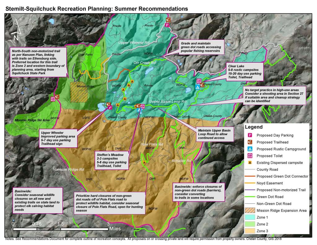
36 commitment from Chelan County to restrict motor vehicle use on Upper Wheeler Road beyond the junction of the connector road and the Upper Wheeler Road. Irrigation districts would retain access to Upper Wheeler Reservoir as needed. Camping, Day-Use, and Trails: For camping and day-use improvements, existing impacted areas will be used; the focus will be on accommodating existing use at peak to average times and reducing spread of impacts. Lily Lake (Section 22): While interest in improvements to recreational facilities at Lily Lake has been expressed in prior planning efforts, no development is proposed for Lily Lake through this planning effort. WDFW will work on developing a management strategy for recreation on the newly acquired Sections 22 and 16.. Options for addressing current recreational impacts in a restorative manner will be assessed through WDFW agency planning efforts under habitat protection guidelines from USFWS. Assess options for designating non-motorized trails near Lily Lake. Improve the existing trail around Lily Lake for walking and hiking use. Clear Lake (Section 23): Formalize camping sites within the currently used area for recreation use. Delineate sites by placing natural edges around the sites. Ensure all campsites have an appropriate fire ring to contain existing campfires and a picnic table. 5-8 walk-in campsites are possible within the current footprint. Allow room to create additional sites in the future if needed. Formalize and improve a parking area and trailhead for day-use including fishing, hunting, hiking, biking, and equestrian use on designated routes. The trailhead should include a vault toilet, trash container, and interpretive and regulatory signs sharing information on rules, expected behaviors, natural and cultural resource information. The parking area should include a pull-through for equestrian/trailer use and parking spots. Assess options for designating non-motorized trails near Clear Lake. Trails could be conversion of non-green dot roads to trails or occur within road buffers of existing open roads. Improve the existing trail around Clear Lake for non-motorized walking and hiking use. See design concept in Appendix B. Upper Wheeler Reservoir Access (Section 29): 36
37 Phase I: Improve the parking area and trailhead near the existing gate for day-use including fly-fishing, hunting, hiking, and wildlife viewing. The trailhead should include a sign identifying rules and regulations (for example, mountain biking on Wenatchee Heights Reclamation District property is not allowed). 5-7 parking spots. Extend green dot road designation to include improved parking area. Provide additional parking at road junction Orr Creek/Upper Basin Loop Road. 5-7 parking spots. Continue to allow dispersed camping at the road junction of Orr Creek/Upper Basin Loop Road, within green dot regulations. See design concept in Appendix B. Phase II: Assess the need for a vault or pit toilet for day use at the improved parking for Upper Wheeler Reservoir access. Steffen s Meadow (Section 28): Phase I: Formalize camping at Steffen s Pond/Meadow to reduce spread of impacts and contain off-road motor vehicle use. Delineate some of the high-use sites by placing natural edges around the sites and restoring vegetation. The campsites will include fire rings to contain existing campfires. 2-3 campsites with vehicle access. Formalize a parking area and trailhead for day-use including fishing, hunting, hiking, biking, and wildlife viewing. The trailhead should include educational and interpretive signage to identify rules and regulations and inform the public of the importance of natural resource conservation. 5-8 parking spots. Formalize and designate non-motorized trails near Steffen s Meadow. Some of these trails could be conversion of non-green dot roads to trails or formalizing usercreated trails. Dispersed campsites will remain available in the meadow, with walkin access. See design concept in Appendix B. Phase II: Develop a vault toilet for day and camping use. This would be phased in to align with the improvements to the green dot road system. All Other Dispersed Sites along Orr Creek/Stemilt Road Loop: Phase I: Maintain all existing dispersed sites that are off the primary Stemilt/Orr loop road that are in compliance with the green dot motorized use rule (within 100 of green dot road). Close or convert to walk-in only all other dispersed sites that are more 37
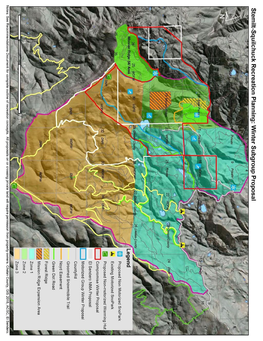
38 than a 100 off the road. Restore impacted areas if any dispersed campsites are closed. Monitor use and impacts at these sites and evaluate use levels to see if additional facilities such as metal fire rings, pit toilets, and borders are needed to contain impacts/hazards. Phase II: Provide facilities at the dispersed campsites including delineating sites, fire rings, and backcountry style toilets as needed based on monitoring results. Other Trails: Create a trailhead/ parking area at base of Upper Wheeler Road (Section 10); 5 parking spots. Add signage identifying rules and regulations. Continue to assess non green dot roads for conversion to non-motorized trails. Assess additional opportunities to create sustainable new trails along the existing green dot road corridor buffer. Evaluate trail proposals for potential impacts to water and wildlife. Target Shooting Phase I: Designate no target shooting zones around high use areas for day-use and camping, following WDFW Public Conduct Rules. Post signs to help achieve compliance with this rule. Phase II: Designate area(s) for target shooting if appropriate sites are found. Evaluate the potential to create a target shooting area near old quarry (Section 27). This site contains steep sides and steep back hill for bullet containment. Consider time and resources needed for cleanup of debris from homemade targets and shells, collaborate amongst agencies to address this need if establishing an intentional shooting area. Zone 1- Winter Sno-Park: Maintain adequate parking at maintained sno-parks for snowmobile access to Stemilt Basin. Create a sno-park at the base of Upper Wheeler Road with a seasonal toilet and adequate parking for non-motorized winter snow sports (snowshoe, backcountry ski, cross-country ski, fat-tire bike). Alternative non-motorized parking could be located at Orr Creek Road. Work with non-motorized winter recreation group to identify optimal location for access to non-motorized area in Section
39 As part of the seasonal green dot road closure proposal, close gates at snoparks when snow falls to prevent wheeled vehicles from driving on groomed snowmobile trails. Trails: Maintain existing groomed snowmobile trail system. Trails in Sections 16 and 22 will be subject to WDFW evaluation of winter recreation impacts to habitat and consultation with US Fish and Wildlife Service for recreation restrictions tied to funding. Designate a non-motorized winter use area per the Naneum plan concept (including the Lake Clara area on WDFW Section 23 identified in the Naneum Plan). The boundary of this area is agreed upon between representatives of both winter motorized and non-motorized users. The non-motorized winter use area will be accessible from Squilchuck State Park, Mission Ridge Ski Area, and Section 16. Identify and mark routes within non-motorized area for snowshoeing, cross-country skiing, back-country skiing, and fat-tire biking. Assess feasibility of designating a snowmobile route link to allow Forest Ridge residents who are authorized to use the Noyd Easement to access the groomed snowmobile system; the route will minimize the distance traveled through the proposed non-motorized winter recreation area. Create an annual permit system for residents of Forest Ridge that includes an educational component on the routes available for motorized use and stewardship of the area; users of this snowmobile link will agree to stay on the designated route. This route may intersect with private property; if so an agreement must be made between Forest Ridge residents and the private landowner. Zone 2 Use in Zone 2 is concentrated around Squilchuck State Park and Mission Ridge expansion area, and is primarily non-motorized. Zone 2- Summer Trails Assess feasibility of creating a north-south trail per the Naneum Ridge Plan. This trail should be located mostly be in zones 2. Explore the potential for a high elevation route within the buffer of the existing road corridors along Mission Ridge and Naneum Ridge roads. Locate trail to ensure high quality user experience. Consider seasonal trail closures during critical wildlife periods as part of the 39
40 proposed trail as per WDFW recommendations. As referenced in the Naneum Plan, Squilchuck State Park and Mission Ridge could provide access points for the northsouth trail. Mission Ridge plans to implement non-motorized multi-use trails linking the Mission Ridge expansion area with Squilchuck State Park and Scout-A-Vista. Trail connectors will be primarily located in the NW corner of Section 19, and include connections with Scout-A-Vista property and Squilchuck State Park. Consider a seasonal closure of trails in this area to protect wildlife, if trails are located in elk calving areas. WDFW will determine locations and duration of seasonal closures on WDFW land. Closures will be communicated via trailhead signage and online notices. Noyd Road Easement currently does and will continue to provide designated motorized vehicle access route for authorized Forest Ridge residents to access Upper Wheeler Road. Implement an annual permit issued for residents that includes educational material and acknowledgment of the rules and regulations of the area. A seasonal closure may also be implemented as needed to protect road conditions, wildlife, and water. Consider strategic fuel breaks and wildfire/fuels reduction planning with trail development. Trailheads and Signage Create a trailhead at the main Mission Ridge parking lot with signage, vault toilet, and garbage collection for hikers going into Stemilt and to Lake Clara. This trailhead will be for non-motorized access into Stemilt and Lake Clara. Develop educational signage to inform visitors about the risk of fires, ways to prevent forest fires, and seasonal trail closures to protect wildlife and/or the trails at all trailheads. Create signage for clarification of trail use types. Use signage to delineate uses for different trails (hiker, equestrian, mountain bike). Camping Provide additional signage on boundaries of Squilchuck State Park to alleviate private property issues (people camping on private property). Consider expanding camping opportunities in Squilchuck State Park (and possibly Mission Ridge property) according to recreation development planning by Washington State Parks and private landowners. 40
41 Zone 2 Winter Trails Create a snowshoe/backcountry ski trail from Squilchuck State Park to Mission Ridge/Section 30 non-motorized winter use area (likely utilizing a summer trail platform). Create groomed cross country ski trails in Section 19 and NE ¼ Section of 30. Evaluate feasibility of connecting to cross country ski trails in Section 17. Designate a non-motorized winter use area per the Naneum plan concept (including the Lake Clara area on WDFW Section 23 identified in the Naneum Plan). The boundary of this area is agreed upon between representatives of both winter motorized and non-motorized users. The non-motorized winter use area will be accessible from Squilchuck State Park, Mission Ridge Ski Area, and Section 16. Identify and mark routes within non-motorized area for snowshoeing, cross-country skiing, and fat-tire biking. Sno-parks Identify non-motorized sno-park locations at Squilchuck State Park, access to Section 16 (Orr Creek or Upper Wheeler Road) and potentially on Mission Ridge property. Work with Washington State Parks Winter Recreation Program to organize non-motorized sno-parks. Zone 3 Zone 3 Summer Trails Continue to provide dispersed hiking opportunities in Zone 3, both off trail and on non-green dot roads that are currently closed to vehicle traffic. WDFW does not support designated trail development in Zone 3 (other than a north-south trail as per Naneum Plan), due to its high value as core summer elk habitat. Maintain undeveloped nature of area east of Mission Ridge ski area and north of Nanuem Ridge (west of groomed snowmobile trails and green dot roads) by leaving the area primitive and used by non-motorized users (this concept applies for both summer and winter). Roads: Prioritize enforcement of closures of non-green dot roads (barriers) in Zone 3 to conserve large areas of contiguous high quality wildlife habitat. 41
42 Consider seasonal closure of Pole Flats road (closed for core summer elk habitat, open in fall for hunting). WDFW recommends this seasonal closure if increased recreation-related wildlife disturbance occurs as a result of recreation plan developments. Zone 3 Winter Consider creating a seasonal winter warming hut at Four Corners on the groomed snowmobile trail system, with a toilet. Consider creating a seasonal back-country hut or yurt on Naneum Ridge in Section 36 for non-motorized winter use, with a toilet. Assess feasibility of non-motorized summer use of hut system as well (for example, as part of a larger hut-to-hut system for hiking or mountain biking). Maintain a non-motorized play area in the high elevation terrain east of Mission Ridge Ski Area, as per the winter non-motorized area mentioned above. This area is accessible to non-motorized travelers due to its proximity to the ski area and Squilchuck State Park, and is agreed upon by both user groups (see winter recreation map). Maintain quality high-elevation off-trail play areas for snowmobile access in terrain closer to the groomed snowmoble routes, traditionally used for off-trail snowmobiling (see winter recreation map). Maps See the following maps for visual representation of the recommendations. Not all recommendations can be mapped, and the combination of the written document and maps is necessary for a comprehensive description. See Exhibit E for a detailed explanation of the winter non-motorized recreation proposal process. Figure 9. Summer Recommendations Map, See Below Figure 10. Winter Recommendations Map, See Below 42
43 43
44 44
45 Chapter 8: Implementation Implementation Framework This plan is intended to lay the foundations for a collaborative path to implementation. Although the Chelan County Natural Resources Department led the effort to develop this plan, many of the recommendations outlined that are outside of Chelan County jurisdiction will ultimately be implemented by the respective landowners, management agencies, nonprofits, or recreationists. The implementation of the Plan s recommendations is intended to be developed over time as funding and opportunities arise. In many cases, grants will be needed to help support the recommendations and a list of potential funding sources can be found in Appendix D. Environmental review, design work, documentation, and necessary permits will also be needed to implement many of the recommendations. It is envisioned that agencies, recreationists, non-profits, conservation groups, and individuals will all work together to help implement the Plan s recommendations. Volunteers and education facilities can offer a wealth of support and resources to the group. The following are early action recommendations that were identified as priorities through input on surveys by the Recreation Committee and Stemilt Partnership as being ripe for implementation and/or having a great deal of support for completing ahead of other recommendations in the Plan. Each of these early action items could feasibly be initiated and even completed in the next one to five years. Some items are ongoing and will continue as high priority elements over the planning duration. These actions are intended to improve visitor experience, protect natural resources, and enhance awareness of the basin and its recreation resources. Cost estimates are not provided as many of the recommendation will need to go through its own planning and design process which would include developing a budget. These early actions are not listed in any particular order for implementation and they can be implemented simultaneously. Various individuals and organizations have come forward to volunteer to help with implementing these recommendations. A preliminary list of implementers is included in the table below. Recreation Implementation Priorities Action/Recommendation Who Implementation/Restoration Steps Green dot roads 45
46 Maintain public access by addressing maintenance needs on 16.6 mile green dot road system in the Stemilt Basin. Grade and maintain roads to high use recreation sites such as Clear Lake for passenger vehicles, and other road sections for 4 X 4 vehicle access. Open a green dot connector road between Upper Wheeler Road and Orr Creek Road in Section 20, to complete a legal motorized access route from Forest Ridge to the green dot road system. This connector would be open to public access, and would alleviate issues of motorized impacts and trespass at Upper Wheeler Reservoir. For winter access, assess feasibility of designating a snowmobile route link to allow authorized Forest Ridge residents to access the groomed snowmobile system. The final route should be the least impactful to the proposed non-motorized area. Consider a seasonal closure of the green dot roads during spring melt off, prevent illegal mudding, and prevent wheeled vehicles from driving on groomed snowmobile trails. DNR, WDFW, Chelan County, irrigation districts Forest Ridge residents, WDFW, El Sendero, Apple Country Snowmobile Club, Wenatchee Valley Ridge Runners ATV Club WDFW, DNR, Chelan County, Stemilt Partnership Roads Committee, Apple Country Snowmobile Club, private landowners at access points On-going Winter: 1. Assess different route options for a winter snowmobile connector on the ground. 2. Select an option that allows public access and provides the least impact to the nonmotorized area, working with private landowners if needed. 3. Develop a permit system for forest ridge residents wanting to access this connection. Summer: 1. Public input process 2. Chelan County Public Works process for restricting motorized use on a county road 3. Revise green dot road maps 1. Convene Stemilt Roads Committee to put together a proposal 2. Present to agency green-dot committee 3. Public input process 4. Implement closure 5. Conduct outreach and education to recreation users with assistance from user groups. 46
47 Non-green dot roads Non-green dot roads are currently closed to public vehicle access. Implement effective vehicle closures on these roads such as gates, tank traps, or natural obstacles. Zone 3 and non-green dot roads off Pole Flats Road are a priority to preserve contiguous areas of habitat. A comprehensive road inventory and analysis should be completed to identify priorities for non-green dot road closure enhancements. WDFW, DNR, Chelan County, Wenatchee Sportsmen Association, Stemilt Partnership Roads Committee 1. Identify funding or technical resources for a comprehensive roads inventory 2. Conduct the roads inventory and identify priority road closure barriers/decommissioning (other priority closures may be identified prior to an inventory, based on wildlife/resource damage) 3. Convene roads committee to advise agencies/landowners on priority recommendations 4. Identify funding and grants to help implement 5. Conduct cultural resources review, SEPA generally not needed 6. Construct barriers on priority non-green dot roads 7. Conduct outreach and education to the community with assistance from user groups Create signs at strategic access points, trailheads, campgrounds, gates, and barriers that describe the green dot road system or other rules/allowed uses. DNR, WDFW, Chelan County, Wenatachee Sportsmen Association, Apple Country Snowmobile Club, El Sendero, other user groups 1. Develop messaging for signs 2. Test the sign messaging for effectiveness 1. Identify funding source for implementation 2. Implement signage 47
48 Education and Enforcement Promote a more active education and enforcement presence, especially along the Upper Basin Loop Road in Zone 1. Chelan County Sherriff s Office, WDFW and DNR enforcement, eyes in the woods volunteers 1. Convene WDFW, DNR, and Chelan County Sheriff s Office to identify a strategy to meet enforcement needs in the basin. 2. Search for grants and other funding revenue, volunteer assistance to increase enforcement. 3. Develop an outreach and education strategy to share about rules and affect visitor behavior. Encourage and assist recreation user groups and volunteers conducting regular clean-ups of the basin WDFW, DNR, Chelan County, Apple Country Snowmobile Club, Wenatchee Valley Ridge Runner ATV Club, El Sendero, Evergreen Mountain Bike Alliance 1. Convene interested groups 2. Conduct outreach to volunteers 3. Host clean-up days 4. Provide assistance such as trailers/trash hauling Summer Use: Camping, Day-Use, Trails Maintenance Engage in collaborative effort between land management agencies to seek additional funding for long-term maintenance of any camping/trailhead facilities before they are installed. Camping and Day-Use WDFW, DNR, Chelan County 1. Convene land managers 2. Develop strategy 3. Identify and pursue grant funding sources 48
49 Dispersed camping opportunities that are in compliance with the green dot road regulations will remain available along the Upper Basin Loop Road. Lily Lake (Section 22): Options for addressing current recreational impacts at Lily Lake in a restorative manner will be assessed through WDFW agency planning efforts under habitat protection guidelines from USFWS. WDFW, DNR, Chelan County WDFW, Stemilt Irrigation District On-going, monitor sites for resource damage/maintenance needs 1. WDFW determine recreation opportunities and constraints for Lily Lake. 2. Develop concepts for restoration and recreation at Lily Lake including potential trail improvements. Assess options for designating nonmotorized trails near Lily Lake. Improve the existing trail around Lily Lake for walking and hiking use. Clear Lake (Section 23): Formalize and delineate 5-8 camping sites. Formalize and improve a parking area for dayuse with parking spots. The trailhead should include a vault toilet, trash container, and interpretive and regulatory signs. Formalize the existing trail around Clear Lake. Upper Wheeler Reservoir Access (Section 29): Improve the parking area for 5-7 spots near the existing gate for day-use. Include signage. Extend green dot road designation to include improved parking area. Chelan County, Stemilt Irrigation District Chelan County, Wenatchee Valley Fly Fishers, Wenatachee Heights Reclamation District 1. Identify funding for construction and long-term maintenance. 2. Work with Stemilt Irrigation on potential improvements 3. Conduct environmental review and permitting 4. Construction. 1. Identify funding for maintenance and construction. 2. Conduct environmental review and permitting 3. Construction 49
50 Steffen s Meadow (Section 28): Formalize 2-3 camping spots at Steffen s Pond/Meadow to reduce spread of impacts. Formalize a parking area for 5-8 spots and include educational and interpretive signage to identify rules. Formalize existing trails near Steffen s Meadow for walking and foot access to meadow. Trails Consider seasonal closures of new and existing trails/routes to protect wildlife, particularly during elk calving season. Seasonal closure dates and locations would be based on input from WDFW wildlife biologists, and would follow the elk calving season of spring-early summer. Undertake feasibility study for northsouth trail as per the Naneum Ridge Plan, primarily in Zone 2. Explore the potential for a high elevation route within the buffer of the existing road corridors along Mission Ridge and Naneum Ridge roads. Locate trail to ensure high quality user experience. This could potentially be done in conjunction with Mission Ridge s expansion project. Trailheads and Signage Create a trailhead at the main Mission Ridge parking lot with signage, vault toilet, and garbage collection for hikers going into Stemilt and to Lake Clara. WDFW, Chelan County, Stemilt Irrigation District WDFW, DNR, Chelan County, Wenatachee Sportsmen Association DNR, State Parks, WDFW, Chelan County, Evergreen Mountain Bike Alliance, Mission Ridge Mission Ridge, Wenatchee Outdoors, other user groups, Chelan County 1. Identify funding for maintenance and construction. 2. Conduct environmental review and permitting 3. Construction 1. Convene land managers to develop proposed timing and locations of the proposed closure. 2. Public input process 3. Implement closure 4. Outreach and education to the community 1. Identify funding 2. Convene a trail study to assess route options. 3. Develop designs for a feasible route 4. Environmental review and permitting. 5. Construction 1. Identify funding. 2. Develop a concept design. 3. Conduct environmental review and permitting. 4. Construct. 50
51 Develop educational signage and information to inform visitors about the risk of fires, ways to prevent forest fires, and seasonal trail closures to protect wildlife and/or the trails at all trailheads. Target Shooting Designate no target shooting zones around high use areas for day-use and camping, following WDFW Public Conduct Rules. Post signs to help achieve compliance with this rule. Winter Use: Sno-park, Trails Sno-Park Maintain adequate parking at maintained sno-parks for snowmobile access to Stemilt Basin. With any closures of established sno-parks, assess opportunities for new parking opportunities and assist local groups with establishment of alternative snopark. DNR, WDFW, Chelan County, State Parks WDFW, Chelan County Chelan County, State Parks, WDFW, Apple Country Snowmobile Club, Wenatchee Valley Ridge Runners ATV Club 1. Develop messaging for signs 2. Test the sign messaging for effectiveness 3. Identify funding source for implementation 4. Implement signage 1. Identify and assess opportunities to replace parking for winter snowmobiling with any snopark closure. 2. Identify a preferred option. 3. Conduct any needed SEPA or cultural resource review. 4. Construct and maintain parking for snowmobiles. Trails Maintain existing groomed snowmobile trail system. Maintain quality high-elevation offtrail play areas for snowmobile access in terrain closer to the groomed snowmobile routes, traditionally used for off-trail snowmobiling. State Parks, Apple Country Snowmobile Club WDFW, DNR, Chelan County, Apple Country Snowmobile Club On-going On-going 51
52 Designate and establish a nonmotorized winter use area. This includes not only sections of zone 1, but also zone 2 and 3. Identify and mark routes within non-motorized area for snowshoeing, cross-country skiing, back-country skiing, and fattire biking. Huts Consider creating a seasonal warming hut at Four Corners on the groomed snowmobile trail system, with a toilet. Consider creating a seasonal backcountry hut or yurt on Naneum Ridge in Section 36 for non-motorized winter use. Assess feasibility of nonmotorized summer use of hut system. El Sendero, Apple Country Snowmobile Club, WDFW, DNR, Chelan County, USFS, Kyle Mathison Orchards, Mission Ridge DNR, Apple Country Snowmobile Club DNR, El Sendero, Evergreen Mountain Bike Alliance 1. Decide on a final alternative 2. Conduct on the ground GPS work and flagging to better delineate the boundaries. 3. Map the non-motorized proposal. 4. Share and educate users about the non-motorized area 5. Propose a Chelan County Public Works seasonal road closure process for Upper Wheeler Road 6. Share proposal with the USFS for consideration in their winter travel management plan. 1. Develop a concept design for the hut and facilities. 2. Conduct environmental review and permitting. 3. Identify funding. 4. Construct 1. Develop a concept design for the hut. Consider winter and summer use. 2. Conduct environmental review and permitting. 3. Identify funding. 4. Construct. Coordination and Roles Implementation Committee s Role An implementation committee will be formed to help guide implementation of the Plan s recommendations, develop a shared annual work plan, and address any continuing issues or opportunities that arise. The role of committee members is described below: 52
53 Participates in meetings representing the views and expertise of their organization and interest from the larger community. Provides support, expertise, direction, and work on annual work plans, products, and other necessary elements of implementing the plan. Seeks and organizes technical assistance and financial grant applications. Organizes and coordinates volunteer opportunities. Helps monitor effectiveness of the Plan s actions. Coordinator s Role Coordination is an important role and vital to the success of implementing the plan. Chelan County Natural Resource Department will continue to provide leadership and coordination of the recreation plan implementation and convene the implementation committee. The primary coordinator responsibilities are described below. Organizes and convenes committee meetings. Facilitates development of an annual work plan and year-end progress report. Provides an organizational link to government agencies, non-profit organizations, and the public. Engages the partners keeping them apprised of activities, grants, and other opportunities for partnership projects. While Chelan County is the lead coordinator, Chelan County is not the lead for implementing actions outside of County lands. Volunteer Labor Many recreation areas are maintained and celebrated through the work of dedicated volunteers and organizations. Existing organizations, such as Wenatchee Sportsmen Association, Evergreen Mountain Bike Alliance, Apple Country Snowmobile Club, Wenatchee Valley Ridge Runners ATV Club, El Sendero Backcountry Ski and Snowshoe Club, Backcountry Horsemen, and Washington Trails Association are examples of partner organizations engaged in volunteer service. Volunteer efforts can support the implementation of the Plan s recommendations and foster a sense of stewardship and ownership by recreation users. Example projects include adopting a site for maintenance, providing labor for special project events, planting trees and restoring riparian areas, conducting volunteer patrols, developing interpretive stories, and organizing cleanup campaigns and/or community celebrations. To use volunteer assistance most effectively, a volunteer program should be established. Components of a successful volunteer program include (1) volunteer coordinator, (2) task identification, (3) training and recruitment, and (4) rewards and recognition. 53
54 It is recommended that Memorandums of Understandings (MOUs) be developed and signed between volunteer organizations and the land managers. MOUs are not legally binding but clearly spell out the roles and responsibilities of all parties. Chapter 9: Monitoring A monitoring plan is designed to provide land managers with a framework to determine whether the goals and objectives of the plan are being met. The following indicators and monitoring strategies were gathered through input from the recreation planning group in November 2017, and refined by land management representatives and County and NPS staff in These indicators and monitoring strategies provide suggestions for how a monitoring strategy could be implemented to determine the success of the plan and identify adaptive management needs and future plan revisions/additions. Potential indicators related to key issues and opportunities Indicators translate desired conditions into measurable attributes (i.e. number of user-created trails) that could be tracked over time to evaluate changes in resource or experiential conditions. Along with input from the recreation committee, the planning team used the key issues and opportunities for the plan to develop related indicators. This process helped identify when management action may be needed given the importance of the resource or visitor experience affected by types of recreation. Thresholds represent the minimum acceptable condition for each indicator and will be established by considering descriptions of the desired conditions, data on existing conditions, staff and committee management experience, and knowledge on public preferences. Although defined as minimally acceptable, thresholds still represent acceptable conditions. Also, establishing thresholds does not imply that no action would be taken prior to reaching the threshold. Thresholds identify when conditions approach unacceptable levels, so threshold serve as warning lights letting managers, user groups, and the public know that corrective action will keep conditions acceptable, ultimately allowing goals to be met and tracked over time. For some indicators, objectives were set, meaning a specific result that the agencies and user groups aim to achieve within a specified time frame. If thresholds serve as warning lights to indicate when conditions are about to become unacceptable, objectives may be established to demonstrate positive progress towards achieving desired conditions. Another distinction between objectives and thresholds is that objectives contain some action that is typically within the control of the agencies/landowners, while thresholds are dependent upon conditions that result from the effects of visitor use. In practice, objectives are typically stated as managerial performance or accomplishment goals, whereas thresholds are typically based on physical, biological, or social resource conditions. 54
55 Indicators, thresholds, objectives, and associated management strategies, could be implemented as a result of this planning effort and are described below. The planning team arrived at the following five indicator topics that would translate the desired conditions into measurable attributes that could be tracked over time: Areas for traditional recreational uses Non-motorized recreation opportunities Use conflicts/illegal activities Effectiveness of green dot road system Preservation of contiguous habitat areas Visitor use management is an iterative process in which management decisions are continuously informed and improved. Indicators are monitored, and adjustments are made as appropriate. As monitoring of conditions continues, managers may decide to modify or add indicators if better ways are found to measure important changes in resource and experiential conditions. Monitoring indicators helps determine the most effective way to manage visitor use to attain desired visitor experiences and resource conditions. The following monitoring framework provides some options for using suggested indicators to track the success of the plan in addressing the original issues and opportunities. Monitoring Framework Key Issue/Opportunity: Continue to provide opportunities for traditional uses such as hunting, fishing, and snowmobiling. Potential indicators: Number of miles of green dot roads to access fishing and hunting Number of vehicle and trailer parking spots to access snowmobile trails Number of miles of groomed snowmobile trails Indicator rationale: These indicators are related to visitor experiences. The indicators can track trends in the access for opportunities for fishing, snowmobiling and hunting within the basin. Potential objective: Over the lifespan of the plan, agencies will work with user groups to provide at least 16.6 miles of green dot roads to access fishing and hunting in the basin (but not more than is suitable for wildlife and maintenance needs), an adequate number of vehicle and trailer parking spots to access snowmobile trails, and maintain the current extent of groomed snowmobile trails. Applicable analysis areas: Zone 1 and Zone 3 Suite of management strategies: different strategies would be chosen at each location, and may vary depending on context such as zoning. Evaluate Educate other users on the importance of traditional uses and importance of resource protection to the Stemilt community 55
56 Maintain current areas and/or the same amount and quality of areas for these user groups Provide parking by maintaining existing areas for these uses. Assess alternative locations for parking if current access is closed, and build new parking areas to support these uses if appropriate. Assist Apple Country Snowmobile Club in maintaining legal sno-park status if any changes in location are made. Designate new areas for fishing, snowmobiling, and hunting Monitoring Approach: DNR tracks the number of green dot roads on state lands. Chelan County can track this for County lands during fishing and hunting seasons within the planning area. May need to address seasonal closures and track differently than how it is currently tracked. Apple Country Snowmobile Club may help with baseline and monitoring of snowmobile parking and trails. Key Issue/Opportunity: Create desired new types of non-motorized recreation opportunities. Potential indicators: Total number of trail miles available to summer non-motorized recreation Total number of designated winter routes available to non-motorized recreation Indicator Rationale: These indicators are related to visitor experience and safety. Visitors that engage in non-motorized recreation activities within the basin have repeatedly requested separate opportunities to enhance safety and enjoyment, due to conflict. These indicators can track agency and user group progress toward the objectives. Potential objective and rationale: Over the lifespan of the plan, agencies will work with user groups to provide at least one new separate trail for summer non-motorized recreation within the basin, delineate at least three separate new designated routes for non-motorized winter recreation (one of each fat-tire bike, snowshoe, and cross country ski routes) within the basin. Applicable analysis areas: Western portion of the planning area, with access points from Squilchuck road, and some access points from Upper Wheeler and Orr Creek Road Suite of management strategies: different strategies would be chosen at each location, and may vary depending on context such as zoning. Evaluate Educate visitors about the importance of multiple uses Provide directional signs and signs encouraging visitors to stay on trail (as appropriate) Maintain current routes and trails 56
57 Improve current route/trail Formalize user-created trails as designated trails, if appropriate Establish and build new routes/trails based on best management practices for trails sustainability. Agencies may consider the USFS Trail Fundamentals & Trail Management Objectives, though not required. Assess for potential connectivity of the trail system. Establish different types of winter routes for different types of uses (i.e. fat tire bike, snowshoe, cross-country skiing), all as part of total number of designated winter routes available. Monitoring approach: User groups will be important for establishing, building, and maintaining sustainable routes/trails, as well as tracking mileage of what is available (El Sendero, Evergreen Mountain Bike Alliance, and Wenatchee Outdoors are examples of user groups that can both help establish these opportunities and help track the length of new non-motorized routes). Key issue/opportunity: Potential conflicts/illegal activies. Key issues/opportunity: Lack of agency resources to conduct adequate backcountry enforcement of illegal recreation uses. Potential indicators: Unendorsed activity Indicator rationale: This indicator is related to visitor experience and resource conditions. Unendorsed behaviors can become a primary safety concern for visitors, residents and LE staff (e.g. campfires during fire bans, drinking while driving, trespassing). Unendorsed activities also impact resources (e.g. dumping, poaching, mudding, wood cutting, not adhering to fishing regulations). Potential objective: No net increase in number of calls related to illegal/unendorsed activity, with 2018 law enforcement activity as a baseline. This objective is based on the availability of law enforcement to patrol/respond to incidents in the basin. Increased law enforcement presence may initially result in an increase of citiations/documented violations, therefore this indicator should be tracked by documenting the amount of time law enforcement was present in the area, rather than by the number of citations issued. 57
58 Applicable analysis areas: Zone 1 and 2 Suite of management strategies: The most effective management strategies would be chosen for each location, and may vary on context such as zoning: Evaluate possibilities of a dedicated law enforcement presence, through grant funding or agency designation Law enforcement emphasis patrols oriented towards educating. Add additional signage delineating private property lines Educating the public via social media and partnering with user groups Partner with user groups on clean-ups and stewardship activities. Establish trail watch/stewards volunteers program. Volunteers would participate in a training class to report on observed law violations. Monitoring Approach: Track time spent by law enforcement personnel in the planning area. Key issue/opportunity: Unlawful motorized use of non-green dot road system due to the lack of information and enforcement. Potential indicator: Number non-green dot roads with gates/barriers/signs installed or roads decommissioned Indicator Rationale: This indicator is related to both resource impacts and visitor experiences. As recreation users leave designated roads, wildlife is impactes, vegetation and soil loss can occur, deep ruts can form, and some user created roads trespass on private land. Recreationists may be leaving designated roads for a variety of reasons such as wanting to reach a destination off of the designated roads, they may not know what is designated or undesignated, or avoid undesirable road conditions. Issues of concern related to this indicator include natural resource impacts such as those described above, trespassing, and recreationist safety. Objective and rationale: Over the lifespan of the plan, agencies will work with partners towards the objective and to achieve visitor experience and resource protection goals. At least 2 non-green dot roads closed with a barrier, signed, or decommissioned per year, with all road closure proposals reviewed by the Stemilt Roads Committee. Applicable analysis areas: All zones. Suite of management strategies: The most effective management strategies would be chosen at each location, and may vary depending on context such as zoning. (then list management strategies from least to most stringent) Evaluate Complete road inventory and assessment, and focus closures on priority roads that are 58
59 causing the greatest impact to wildlife/natural resources. Educate motorists about the importance of staying on designated roads including use of social media Eradicate excess roads Provide informational signs and signs encouraging motorists to stay on designated roads Improve roads Relocate and or redesign roads to address resource issues related to green dot roads Construct Barriers (fences, etc.) Prioritize road closures and monitoring based on related resource impacts Monitoring approach: Track closures of non-green dot road implemented Track usage of non-green dot roads with traffic counters (WDFW) 59
60 Key issue/opportunity: Impacts of current and future recreation use on wildlife, water, and natural resources. Potential indicators: Size of contiguous areas 500 from green dot roads and trails Buffers around wetland/riparian areas maintained Indicator rationale: This indicator is related to resource protection and visitor experience. As visitors leave designated roads, vegetation, soil loss, and wildlife flushing can occur. Areas of contiguous habitat are important for wildlife within the basin as well as for water quality. Undeveloped areas are also important for those visitors who travel by foot and seek opportunities for solitude and exploration. The 500 indicator was chosen simply as an indicator of undeveloped lands, and does not reflect true wildlife impact buffers. The contiguous size of polygons of undisturbed area provides the indicator of quality habitat that is not sliced and diced by recreation routes. To measure areas, these can first be determined and then measured in GIS. A similar method could be used for assessing the riparian buffers and intersections with roads and trails to more specifically address rivers/water protection. Threshold and rationale: Maintain contiguous undeveloped habitat polygons in critical habitat areas, with a minimum of 3 polygons that increase in size over the planning period by reducing impacts of non-sanctioned routes (non-green dot roads or user-made trails. Applicable analysis areas: Entire basin, with particular emphasis on contiguous habitat area in Zone 3. Suite of management strategies: Evaluate Re-route existing recreation routes around sensitive areas Plan trails and roads to avoid bisecting large contiguous undisturbed areas Restore impacts to sensitive riparian areas Monitoring approach: Re-measure every five years throughout the basin to see if size of contiguous areas 500 from green dot roads and trails has increased, decreased, or remained constant Identify 3 priority areas to increase size of contiguous undisturbed area In addition to the potential indicators outlined above, the recommendations specifically call out the monitoring of dispersed campsites for impacts that indicate additional management needs. Dispersed campsites in the basin currently have no facilities, but if impacts exceed levels that verge on public safety, sanitation problems, or 60
61 resource damage, this plan recommends considering installation of metal fire rings, pit toilets (wallowa style, as can accommodate backcountry style use levels), and borders to reduce wildfire risk, contain human waste, and prevent spread of impacts. These campsites can be monitored by agency personnel or volunteer recreational users reporting on site conditions. Visible signs of fires that have escaped fire rings, toilet paper and/or human waste, and expanding footprint of sites and associated vegetation damage will indicate the need for potential additions to dispersed campsites. This plan emphasizes a phased approach, with some elements only occurring as needed and determined by use/impact levels. This approach is a way to anticipate future uses and provide guidance for managing recreational pressure that may increase over time in this area. The monitoring component provides a way to ensure the values of the community that were identified during this planning process are still being met within the planning area. Utilizing this monitoring component throughout the planning period will help determine adaptive management needs and provide data that can be used in future plan updates. 61
62 Appendices Appendix A: Stemilt-Squilchuck Recreation Committee Charter Vision: Establish sustainable recreation opportunities in the Stemilt-Squilchuck Basin through a community based planning process that embraces community values, protection of water and wildlife resources, and collaboration with all stakeholders. Lead Agency Chelan County Natural Resources Department is the lead agency coordinating the recreation planning process. Technical Assistance: The National Park Service s Rivers, Trails, and Conservation Assistance Program is providing technical assistance to Chelan County and its partners. Recreation Committee Role: The recreation committee has been formed to help guide and advise Chelan County, Stemilt Partnership, and land managers on the development of the Stemilt-Squilchuck Recreation Plan. The role of the recreation committee is to represent the community and its varied interests groups during the planning process. The recreation committee members will have the opportunity to participate in and provide input throughout the planning process prior to a broader public review. The recreation committee s responsibilities are: Attend approximately 5 to 7 meetings (3 hours each) over the next months (Spring 2017 to Summer/Fall 2018) These meetings will be to review and comment on draft information and to participate in discussions and brainstorming session designed to incorporate their thinking into the process. In addition, it is likely that two or more public events will occur during the planning process with which committee members will be invited to participate in. Provide support, expertise, and direction on all elements of the planning process from start to finish (i.e. outreach strategy, desired conditions, recreation and resource inventory, recreation plan concepts, draft plan, monitoring strategy). Committee members will participate fully in the process and share their ideas and concerns early and often. Committee members will seek to work collaboratively with other members to reach consensus. Serve as a liaison to their respective agency, nonprofit group, recreation user group, partnership team, or company. As a liaison, the committee member will bring input into the process from their larger constituency group as well as share the results of the recreation planning process with their recreation user group, partnership group, agency leadership, or company leadership. This is critical role and vital to the success of the plan. 62
63 Decision-making Process: The recreation committee will make recommendations to the Stemilt Partnership. The recreation committee will seek to make decisions by consensus, if consensus can t be reached by all, then they would first seek to modify the proposals to reach consensus. If consensus could still not be reached, the recreation committee would describe the different perspectives and present this to the Stemilt Partnership. The Stemilt Partnership will consider this input and working by consensus vote as described in their operating procedures will make final recommendations to the designated land manager/owner. The ultimate decision lies with the land manager. Any recommendations approved by the land manager would be incorporated into the plan. Recreation committee Recommend by consensus; if consensus can t be reached present all sides Stemilt Partnership Approve by consensus vote Land Manager Final approval for components on their land Stemilt- Squilchuck Recreation Plan Consensus: All members must support a decision for it to carry. A decision reached by consensus can sometimes represent a wide a range of support. When useful, a simple rating system will be used to help committee members individually and collectively evaluate where they stand in their consensus-based decisions. 1. Support (Consensus) 2. I can live with the decision and accept it, even though it may not be exactly what I want. (Consensus) 3. Cannot support (No Consensus) Committee Membership The recreation committee membership is listed below. The committee will strive to include one (or two) representative(s) from each of the recreation user groups who either use the area or have the potential to use the area. Members are encouraged to actively participate in the process (see role and responsibilities above). 63
64 Active Membership Organization Representative Chamber of Commerce Matt Kearny, Patrick Nolan, Kari Johnson Evergreen Mountain Bike Travis Hornby El Sendero Backcountry Ski and Snowshoe Gus Bekker, Andy Dappen, Chester Marler Wenatchee Valley Fly Fishers Bruce Merighi Wenatchee Sportsmen Jerry Gutzwiler, Dave Gimlin Apple Valley Snowmobile Club Jim Burts, Tom Hendrickson, Gene Reed Wenatchee Outdoors Sarah Schafer Wenatchee Valley Ridge Runners ATV Donna Germain Chelan-Douglas Land Trust Mickey Fleming Backcountry Horsemen Ken Bailey Wenatchee Valley College Ariahna Jones Our Valley Our Future Steve Maher Chelan County Natural Resource Department Erin McKay and Mike Kaputa Washington Department of Fish and Wildlife Pete Lopushinsky, William Moore Wildlife Specialist John Lehmkuhl Stemilt Growers Ben Alworth Washington State Parks Brian Patnode Mission Ridge Josh Jorgensen Washington Department of Natural Larry Leach Resources Stemilt Partnership Steering Committee Jerry Gutzwiler, Herb Troxel, James W. Wiggs Wenatchee Heights Irrigation District James (Will) Wiggs Stemilt Irrigation District Kevin Juchmes Chelan County Commissioner Kevin Overbay Washington Trails Association Cody Gillin Residents of the Stemilt-Squilchuck Basin Cindy Uren United States Forest Service Les Moscoso Potential Membership Other community members may be interested in participating in the future. Any potential new members should reach out to Chelan County. Chelan County seeks to create an open and transparent planning process and will grant new memberships when feasible. New members will need to be able to review relevant information regarding the progress made in the planning process so they can engage effectively. Observer Guidelines. Anyone from the public is welcome to observe the recreation committee meetings. Any observer wanting to make comments can let Chelan County know ahead of time and they will be incorporated into the agenda for the meeting. 64
65 Observers interested in joining the committee can work with Chelan County as described above. Public Input/Outreach. In addition to the recreation committee members, Chelan County and its partners will be reaching out to the other interested and potentially affected community members and funders at key times in the planning process to share information and gather input. Outreach methods may include e-newsletter articles, website updates, press releases, open houses, and surveys. 65

66 Appendix B: Concept Drawings Figure 11. Clear Lake Draft Design Drawing 66

67 Figure 12: Steffen s Meadow Draft Design Drawing 67
68 Figure 13. Upper Wheeler Reservoir Access Draft Design Drawing 68
69 Appendix C: Public Comment Response Approximately 220 public comments were received during the 90 day comment period from March 21- June 18. Verbal comments were also captured at the March 21 Open House in Malaga. Comments were compiled and are on record with Chelan County Natural Resource Department (see below for website). Comments were submitted by members of the public and local businesses, as well as the following organizations: Wenatchee Sportsmen s Association El Sendero Backcountry Ski and Snowshoe Club Washington Trails Association State of Washington House of Representatives Cary Condotta s Office Evergreen Mountain Bike Alliance Forest Ridge Subdivision Conservation Northwest Washington Wild Wenatchee Outdoors The Wilderness Society Wildwater River Guides Sierra Club North Cascades Conservation Council Alpine Lakes Protection Society Winter Wildlands Alliance North Central Washington Audubon Society Washington Outdoor Alliance Chelan-Douglas Land Trust Comments were grouped into comment type and responses to comment by subject are as follows. The comprehensive table of comments can be viewed on the Chelan County Natural Resources Stemilt Partnership website here: While the majority of public comments were regarding winter recreation proposals, all comments were considered equally and were weighed carefully when revising the plan recommendations. Variations of the draft recommendations with track changes and WDFW input can be viewed on the website above and show several rounds of revisions to the recommendations. Appendix E of this document provides a detailed account of the revisions to the winter recreation proposal. Comment Comments in opposition to a non-motorized winter recreation area. Strong sentiment from the motorized community that motorized areas are already limited and Response In response to concerns from the motorized community about a potential reduction in ridable area, additional representatives from the motorized community joined the planning group 69
70 are becoming more limited with new travel restrictions non-motorized users are not restricted from any area, and there is plenty of wilderness in this area for nonmotorized experience the area within the March 2018 proposal encompasses the highest quality snow and terrain in the basin there is currently no issue with sharing the area with motorized and nonmotorized snowmobile use is very established in this area but not many skier/snowshoers use it these are public lands that should be open to all uses the proposal supported by Apple Country Snowmobile Club should be adopted by the County and agencies noise ordinance for snow machines could help resolve some conflict between motorized and non-motorized user groups Comments in support of a non-motorized winter recreation area. Strong sentiment from the non-motorized community that the proposed area is reasonable and equitable in the big picture motorized and non-motorized recreation cannot co-exist in the same place because motorized activity is highly impactful on the experience and safety of non-motorized users a balanced approach to recreation should be implemented in the basin there is no designated non-motorized winter area on state lands in Washington and this reflects an imbalance in recreational management there cannot be a motorized route crossing through a non-motorized area the 2015 Naneum Plan, formally adopted by WDFW and DNR, calls for nonmotorized winter recreation opportunity Comments in support of allowing ATV use in the planning area and not closing green dot roads for vehicle access and presented a counter-proposal that reduced the size of the proposed non-motorized area but still included the non-motorized opportunities outlined in the Naneum Plan. A subgroup containing equal representation of motorized and non-motorized users, with observation from land managers, worked on refining the boundaries in a way both groups agreed on. This process is detailed in Appendix E of this plan. The compromise proposal is supported by representatives of Apple Country Snowmobile Club, and is reflected in the revised Winter Recommendations map. In addition, the recommendations include ensuring adequate parking for snowmobile access to the planning area as a high priority action that Chelan County is willing to assist Apple Country Snowmobile Club with. While the proposal for a non-motorized area evolved over the planning process as mentioned above and in Appendix E, the plan does include a recommendation for a non-motorized winter use area. The agencies have expressed that the proposal contained in the plan meets the goals of the Naneum Plan, and both motorized and non-motorized representatives have agreed on the compromise proposal. Recommendations include a non-motorized winter use area, signage and trails for snowshoeing, cross-country skiing, and fat-tire biking, and non-motorized snow-parks. The recommendations were revised to negate the need to close green dot roads for any reason other than resource protection. 70
71 Comments in support of opening a green dot connector road between Orr Creek and Upper Wheeler Road Comment in support of addressing parking issues for ATVs and snowmobiles at the base of Jump-off Road Comment in support of light-handed management and not spending tax-payer dollars to develop recreation opportunity in the Stemilt basin Comments in support of wildlife protection measures such as maintain large contiguous areas of habitat, free from road or recreation impacts implement seasonal closures on new routes close Pole Flats road to motorized use completing a comprehensive road inventory and habitat assessment closing non-green dot roads to vehicle use Comments on concerns for wildfire, including metal fire rings with lids should be installed at campsites need to be able to close roads during high fire danger should focus on fuels reduction efforts Comments on the need for more enforcement, including don t spend money developing new recreation facilities until you can enforce what already exists more enforcement needed to regulate green dot road usage, illegal dumping, etc. Request to show the north/south nonmotorized trail on the summer recommendations map The green dot road connector is supported as long as the end of Upper Wheeler road (from where the connector road branches off to the end of the current County Road) can be gated to reduce resource impacts in the Upper Wheeler Reservoir area. The motorized representatives from the planning group are aware of this issue and while a solution is not included in this plan, motorized groups will work with landowners to assess options for vehicle parking near Jump-off Road This approach is discussed in the Alternatives section of the plan. The Wildlife Considerations chapter discusses WDFW input recommendations based around wildlife protection. The Alternatives section also discusses a wildlife protection-based approach. The Monitoring section addresses the goal of protecting large contiguous areas of habitat and how this indicator can be measured. Although the public input determined that closing Pole Flats road would be an unacceptable impact on motorized recreation, all of the other comments listed here are directly addressed in the recommendations. The recommendation to close Pole Flats road was revised to consideration of a seasonal closure of Pole Flats road, open for hunting season. The recommendations were revised to include more wording on education and response related to wildfire. While not addressed in this plan, there is a large-scale fuels reduction effort currently ongoing across ownerships in the Stemilt- Squilchuck upper watershed. This is recognized as a critical part of the recreation plan, and is reflected in the recommendations. While the plan does not obligate agencies to increase law enforcement presence, collaborative efforts are underway to find funding sources to support increased law enforcement in the basin. The exact location of the North-South trail is unknown, and needs further analysis to be determined. However, this plan recommends that it occur in Zone 2, starting from Squilchuck 71
72 Request to mention fat-tire biking as a nonmotorized winter use included in the trail system Request to take out wilderness feel wording for Zone 3, it is misleading Request to include summer non-motorized use for the recreation hut proposed on Nanuem Ridge Request to clarify which trails/routes would be subject to seasonal closures for wildlife, and how this will be communicated to the public State Park and potentially crossing Mission Ridge property and passing through Mission Ridge permit area enroute to Naneum Ridge. This general area is called out for the trail location on the Summer Recommendations map. Wording on fat-tire biking was added to the winter recommendations. The wilderness feel wording was removed from Zone 3 description. Wording to assess feasibility of summer nonmotorized use for the recreation hut proposed on Naneum Ridge was added. Wording to clarify seasonal closure alerts was added to the recommendations. Appendix D: Potential Grant Funding Sources RCO Recreation and Conservation Office Recreation Grant Programs -NOVA -WWRP -RTP North Central Washington Community Foundation Regional Impact Grant Wenatchee Sportsman Association Rocky Mountain Elk Foundation WA State Parks Winter Recreation Program Appendix E: Winter Recreation Proposal Evolution Non-Motorized Winter Recreation Proposal Process The recommendation for non-motorized winter recreational opportunity in the planning area was the subject of the majority of public comment and a topic of great importance for residents and recreationalists of the Wenatchee valley and surrounding areas. Due to the broad spectrum of public opinion and the planning parameters that the recreation committee worked within, the non-motorized winter recreation subject required significant effort and coordination among a diverse stakeholder group. To provide transparency to the public and clarity to the entities evaluating this plan, the steps taken to arrive at the proposal(s) included in this plan are outlined below. 72
73 The non-motorized winter recreation proposal originated with the 2015 DNR and WDFW Naneum Ridge to Columbia River Recreation and Access Plan. The Naneum Plan includes the concept map shown below and the following Objectives and Strategies for winter recreation in the Stemilt basin: Figure 14. Naneum Plan Winter Concept Map Objective F: Provide a non-motorized winter trail system. Strategies 1. Partner with the public to identify trail location options within the area identified on the Concept Map-Winter. 2. Plan, design, and develop winter non-motorized trails. 3. Provide non-motorized winter access at Clara Lake and additional areas shown on the Concept Map-Winter. 4. Coordinate the design of the non-motorized winter trails and play areas with input from non-motorized users and the snowmobile community. 73
74 Objective G: Continue to provide winter motorized recreation in the Recreation Planning Area. Strategies 1. Continue existing agreement with Washington State Parks to maintain existing snowmobile trails in the Recreation Planning Area. 2. Maintain winter snowmobile trails in the Recreation Planning Area. 3. Continue to enforce existing snowmobile winter restrictions east of the Colockum Pass Road and in the West Bar area. Having adopted the Naneum Plan, WDFW and DNR are both committed to following through with the objectives and strategies outlined in the plan. However, the concepts as shown in the Naneum Plan were drawn from the 30,000ft level, and further planning by a group of local stakeholders was needed to identify the specific areas and boundaries that would provide the opportunities mandated by the Naneum Plan in a way that made sense on the ground. Several members of the Stemilt-Squilchuck recreation committee were involved in the Naneum planning process, and provided the Stemilt-Squilchuck group with background on the origin of the Naneum concept. In addition, agency staff involved in the Naneum Plan were able to provide insight to the Stemilt-Squilchuck group on the intent of the Naneum Plan objectives and strategies. The Stemilt-Squilchuck recreation committee picked up where the Naneum Plan left off, by including the non-motorized winter recreation concept in the list of initial concepts. The non-motorized winter recreation proposal was presented as a non-motorized use area mapped by El Sendero Backcountry Ski and Snowshoe Club representatives. The proposal, using a delineated area as way to provide non-motorized winter recreation experience rather than the trails and play areas outlined in the Naneum Plan Strategy, used the groomed snowmobile trail system as the eastern boundary and encompassed the play areas shown on the Naneum concept map and additional areas to the west of the groomed snowmobile trail system, Section 29, and some portions of private property. This proposal was discussed by the planning group, which included members from the Apple County Snowmobile Club, and the proposed boundary of the area was not disputed within the group at this stage. The original proposed non-motorized area is shown on the map below. 74

75 Figure 15. El Sendero Original Winter Proposal Map This map was shared in an initial public outreach effort in December 2017, via an ed survey to the Stemilt Partnership and local residents. 47 responses were received from this survey, and concern was expressed about the size and coverage of the non-motorized area proposal. One concern heard from several citizens was that the proposed nonmotorized area completely surrounded a section of private property, essentially landlocking this section from motorized winter access. Other concerns were heard that the proposed area encompassed some well-established and highly valued off-trail snowmobile riding areas. At the November 2017 planning meeting, response to these concerns, the boundary was shifted away from the privately owned Section 21 in the lower basin. A portion of the upper basin that was surrounded by groomed snowmobile trail was also removed from the area. However, the proponents of the original proposal were not willing to shift the boundary in the highest elevation parts of the basin. The revised map incorporating these changes is as follows. 75

76 Figure 16. March 2018 Open House Winter Recommendation Map This map, which encompasses the conceptual play areas shown on the Naneum map, plus Section 29 and some additional area just west of the groomed snowmobile trail system, was presented at the public open house at the Malaga Fire Hall on March 21, The public meeting had high attendance, and many attendees were motorized users who were concerned about the winter recreation proposal and the impacts it would have on established snowmobile use in the basin. A 90 day public comment period began following the open house, and as previously mentioned, this proposal was the topic of the majority of public comments. Over 170 public comments were received regarding this proposal; comments were nearly evenly split between support for and opposition of the proposed non-motorized area. Public comments can be viewed on the Chelan County Natural Resource Department website at In April of 2017, the motorized community, led by the Apple Country Snowmobile Club, organized a gathering to discuss this proposal. This gathering had over 100 attendees, and staff from Chelan County were in attendance to provide background on the origin of the 76

77 proposal. There was strong opposition to any type of non-motorized area in the Stemilt basin, but it was also recognized that because of past and current planning efforts, the motorized community needed to organize a response to the proposal that would fall within the parameters of the state-adopted Naneum Plan. While the motorized group organized this effort and nominated representatives, the planning group welcomed several more members from the motorized community in recognition that this group had not been adequately represented in the planning process to date. In May 2018, the motorized group representatives presented their counter-proposal to the planning group at a recreation planning meeting. This proposal also focused on a nonmotorized area that included many of the conceptual play areas shown in the Naneum Plan, but substantially lessened the amount of high-elevation off-trail area that was included in the original proposal. The counter-proposal shared at the May meeting is shown below. Figure 17. Motorized Group Winter Proposal Map 77
78 This proposal was discussed at the planning meeting, and a general consensus at the meeting implied that the group thought more work was needed, but that something close to this proposal would likely be acceptable to the group. A sub-grouped was formed, with equal representation from motorized and non-motorized groups, with the intent of continuing work on this proposal between planning meetings. The winter recreation subgroup met twice, in June and July of The group refined boundaries to find a compromise that both motorized and non-motorized representatives thought could provide the experiences both groups desired. During the course of these subgroup meetings, El Sendero Backcountry Ski and Snowshoe Club held a board meeting and the decision was made that El Sendero would officially not agree to any changes to the proposal shown at the March open house. However, the subgroup continued, without the affiliation of El Sendero, to work on a proposal that represented a compromise between the original proposal and the counter-proposal. The subgroup meetings were also attended by agency representatives observing the process and noting the compromise discussed by the subgroup. The compromise proposal resulting from this collaboration is shown below. 78
79 Figure 18. Compromise Winter Proposal Map This compromise proposal was presented to the planning group at the July 2018 planning meeting. The proposal was met with majority agreement, but because it did not have complete consensus (El Sendero still providing opposition), the group will follow the guidance of the Recreation Planning Committee Charter and present all sides to the Stemilt Partnership and land management agencies. The following map shows three proposals overlaid to clearly show the differences between proposals. Two proposals are not included in this map: the initial proposal that was created by El Sendero that was altered to accommodate the private land ownership, and the do nothing proposal from the motorized group that would focus on non-motorized trails but not include a designated non-motorized area. It is important to recognize that there were ideal scenarios for each group, but that three proposals shown on the following map all represent compromises on different ends. 79
 is 17,995 acres (the planning area does not include area currently within the Mission Ridge Ski Area")
80 Figure 19. All Winter Proposals Map The total planning area, including WDFW Section 23 (Lake Clara area) is 17,995 acres (the planning area does not include area currently within the Mission Ridge Ski Area Boundary). The total acreage of state and county land within the planning area is 12,953 acres. The amount of state/county land within the planning area encompassed by each non-motorized area proposal is as follows (not including Squilchuck State Park, which is already nonmotorized, or the Mission Ridge Ski Area Boundary): El Sendero Proposal: 4,535 acres Motorized Counter-proposal: 1,882 acres Compromise Proposal: 3,026 acres These calculations don t include USFS or private lands. The Naneum Plan concept drawing encompasses approximately 3,780 acres. It should also be noted that the Mission Ridge permit area boundary, which is larger than the current ski area boundary, is already nonmotorized and occurs of state land, so there is some overlap of the area proposed to be 80

81 included in the non-motorized area, and area that is already non-motorized under the Mission Ridge special use permit. Also of interest to user groups who are looking for off-trail recreation experiences with high quality terrain and snowpack is the amount of high-elevation terrain included in each proposal. The following map shows elevation changes through the planning area, with the different proposal boundaries overlaid. This gives some perspective on the amount of high-elevation terrain included in each proposal. Figure 20. Stemilt Elevation Map with All Winter Proposals Of that: 1,682 acres are 6,000ft or higher 4,133 acres are 5,000-6,000ft 4,614 acres are 4,000-5,000ft 81
82 The different proposals include the following percentages of the highest elevation terrain in the basin (6,000ft or higher): El Sendero proposal: 51% Motorized group counter-proposal:21% Compromise proposal: 36% There are still several issues that will need to be worked out with implementation. The following points will need to be addressed through continued stakeholder involvement: 1. A motorized route providing access from Forest Ridge neighborhood to the groomed snowmobile trail system, that crossess the non-motorized area with the least impact possible, needs to be established. This will require coordination between Forest Ridge residents, private landowners, and the motorized and nonmotorized group representatives. 2. A strategy to include the USFS and private properties included in the proposed area needs to be identified. Several options exist: a) the portions of the area on these lands are designated as voluntary and unenforced, with no mandate on the land owner to adopt this policy, b) not include these areas at all and assume that because they are surrounded by non-motorized area that they won t get motorized use, or c) work with USFS and private landowners to officially adopt these areas as enforceable non-motorized areas. The recommended option here is option a, with proposals to USFS and landowners to adopt this policy when they complete winter travel planning. 3. Upper Wheeler Road is currently a County road that is open to motorized vehicles year-round. The County road passes through Sections 16 and 20, which are WDFW lands and are included in the non-motorized area in all proposals. The planning group recommends that Chelan County Public Works consider a process, utilizing the public planning that has occurred in this planning effort, to include the portion of Upper Wheeler road that passes through Sections 16 and 20 in a non-motorized winter management area (not allowing motorized use on these portions of the road during the winter season). The majority of the planning group feels that the compromise proposal represents a goodfaith effort to reach a compromise between all user groups that can provide the opportunities mandated by the Naneum Plan by providing high-quality terrain and access to both motorized and non-motorized users. Agency staff have also shown support for this compromise proposal and the collaboration that occurred between user groups in reaching it. This document provides background on the work done by the both the planning group 82
83 and the community at large to bring the Naneum concepts to a point where they can be implemented on the ground in a way that works for the local community. The group now relies on the Stemilt Partnership and land management agencies to make the final decision on which proposal to accept and include in the Stemilt-Squilchuck Recreation Plan. 83

84 Appendix F: Naneum Plan/Stemilt Plan Area Overlap Context Map = State lands included in the Stemilt-Squilchuck Recreation Plan 84
Preferred Recreation Recommendations Stemilt-Squilchuck Recreation Plan March 2018
 Preferred Recreation Recommendations Stemilt-Squilchuck Recreation Plan March 2018 Below are the recommended recreation ideas and strategies that package together the various recreation concepts compiled
BACKCOUNTRY TRAIL FLOOD REHABILITATION PROGRAM
 BACKCOUNTRY TRAIL FLOOD REHABILITATION PROGRAM Backcountry Trail Flood Rehabilitation A June 2013 Flood Recovery Program Summary In June 2013, parts of Southern Alberta were devastated from significant
Rogue River Access and Management Plan Draft Alternatives
 Rogue River Access and Management Plan Draft Alternatives The Rogue River Access and Management Plan was initiated in December, 2011 and is being led by Jackson County Parks (JCP) and Oregon Department
Proposed Action. Payette National Forest Over-Snow Grooming in Valley, Adams and Idaho Counties. United States Department of Agriculture
 United States Department of Agriculture Forest Service January 2012 Proposed Action Payette National Forest Over-Snow Grooming in Valley, Adams and Idaho Counties Payette National Forest Valley, Adams
RE: Access Fund Comments on Yosemite National Park Wilderness Stewardship Plan, Preliminary Ideas and Concepts
 September 30, 2016 Superintendent Yosemite National Park Attn: Wilderness Stewardship Plan P.O. Box 577 Yosemite, CA 95389 RE: Access Fund Comments on Yosemite National Park Wilderness Stewardship Plan,
Proposal to Redevelop Lower Kananaskis River-Barrier Lake. Bow Valley Provincial Park. Frequently Asked Questions
 Proposal to Redevelop Lower Kananaskis River-Barrier Lake Bow Valley Provincial Park Frequently Asked Questions What is being proposed? What are the details of the proposal? Where is the project area located?
Logo Department Name Agency Organization Organization Address Information 5700 North Sabino Canyon Road
 Logo Department Name Agency Organization Organization Address Information United States Forest Coronado National Forest 5700 North Sabino Canyon Road Department of Service Santa Catalina Ranger District
Land Management Summary
 photo credit: ANGAIR Anglesea Heath Land Management Summary The Anglesea Heath (6,501 ha) was incorporated into the Great Otway National Park in January 2018. This provides an opportunity to consider the
FINAL TESTIMONY 1 COMMITTEE ON RESOURCES UNITED STATES HOUSE OF REPRESENTATIVES. July 13, 2005 CONCERNING. Motorized Recreational Use of Federal Lands
 FINAL TESTIMONY 1 STATEMENT OF DALE BOSWORTH CHIEF Of the FOREST SERVICE UNITED STATES DEPARTMENT OF AGRICULTURE Before the SUBCOMMITTEE ON FORESTS AND FOREST HEALTH And the SUBCOMMITTEE ON NATIONAL PARKS,
January 14, Orange County Transportation Authority Attn: M2 NCCP/HCP 550 South Main Street P.O. Box Orange, CA
 Equestrian Trails, Inc. Corral 357 P.O. Box 1026 Trabuco Canyon, CA 92678 http://saddlebackcanyonriders.com/ President: James Iacono... 714-612-1789 January 14, 2016 Orange County Transportation Authority
Continental Divide National Scenic Trail Legislative History and Planning Guidance
 Continental Divide National Scenic Trail Legislative History and Planning Guidance Legislation, Policy, and Direction Regarding National Scenic Trails The National Trails System Act, P.L. 90-543, was passed
Proposal to Redevelop Lower Kananaskis River-Barrier Lake. Bow Valley Provincial Park
 Frequently Asked Questions Proposal to Redevelop Lower Kananaskis River-Barrier Lake Bow Valley Provincial Park Frequently Asked Questions What has been decided? What are the details of the plan? What
As outlined in the Tatshenshini-Alsek Park Management Agreement, park management will:
 Management Strategy General Strategy The priority management focus for the park is to ensure that its internationally significant natural, cultural heritage and recreational values are protected and that
Rule Governing the Designation and Establishment of All-Terrain Vehicle Use Trails on State Land
 Rule Governing the Designation and Establishment of All-Terrain Vehicle Use Trails on State Land 1.0 Authority 1.1 This rule is promulgated pursuant to 23 V.S.A. 3506. Section 3506 (b)(4) states that an
Sawtooth National Forest Fairfield Ranger District
 United States Department of Agriculture Forest Service Sawtooth National Forest Fairfield Ranger District P.O. Box 189 Fairfield, ID. 83327 208-764-3202 Fax: 208-764-3211 File Code: 1950/7700 Date: December
PURPOSE AND NEED. Introduction
 Public Scoping: Allocation of Recreation Capacity for Commercial Outfitter Guide Services on North Kruzof Island Trails (Kruzof Island Outfitter Guide) PURPOSE AND NEED Introduction The U.S. Department
DECISION MEMO. Rawhide Trail #7073 Maintenance and Reconstruction
 Page 1 of 6 Background DECISION MEMO USDA Forest Service Jefferson Ranger District Jefferson County, Montana Rawhide Trail #7073 is located in the Elkhorn Mountain Range approximately 10 miles east of
ROAD AND TRAIL PROJECT APPROVAL
 ROAD AND TRAIL PROJECT APPROVAL www.marincountyparks.org Marin County Parks, 3501 Civic Center Dr, Suite 260, San Rafael, CA 94903 DATE: July 12, 2017 PRESERVE: Gary Giacomini Open Space Preserve PROJECT:
Parkland County Municipal Development Plan Amendment Acheson Industrial Area Structure Plan
 Parkland County Municipal Development Plan Amendment Acheson Industrial Area Structure Plan New Plan Acheson Industrial Area Structure Plan Amendment Parkland County Municipal Development Plan Board Reference
CHAPTER 5. Chapter 5 Recreation Element
 CHAPTER 5 Recreation Element Chapter 5 Recreation Element The Recreation Element of the Meyers Area Plan is a supplement to the Recreation Element of the TRPA Regional Plan and the El Dorado County General
MANAGEMENT DIRECTION STATEMENT June, 1999
 Thompson River District MANAGEMENT DIRECTION STATEMENT June, 1999 for Roche Lake Provincial Park Ministry of Environment Lands and Parks BC Parks Division Table of Contents I. Introduction A. Setting
Restore and implement protected status that is equivalent, or better than what was lost during the mid-1990 s
 THE ROSSLAND RANGE, OLD GLORY AREA. Executive summary. The Friends of the Rossland Range Society, on behalf of the local outdoor community, seeks to accomplish the following with respect to the Old Glory
Creating a User-Driven Long-Distance OHV Trail Through Partnering
 Joseph Raffaele Outdoor Recreation Planner U.S. Bureau of Land Management Yuma, Arizona Creating a User-Driven Long-Distance OHV Trail Through Partnering BLM is a multiple-use land management agency within
EXECUTIVE SUMMARY PROGRAM DEVELOPMENT REPORT PURPOSE EXISTING SETTING EXPANDING PARKLAND
 EXECUTIVE SUMMARY PROGRAM DEVELOPMENT REPORT PURPOSE As the culmination of the first phase of the master planning process, this Program Development Report creates the framework to develop the Calero County
Longmont to Boulder Regional Trail Jay Road Connection DRAFT FINAL REPORT
 Longmont to Boulder Regional Trail Jay Road Connection DRAFT FINAL REPORT December 2018 Project Summary Boulder County, Colorado, in partnership with the City of Boulder, is evaluating options for multi-use
JOSLIN FIELD, MAGIC VALLEY REGIONAL AIRPORT DECEMBER 2012
 1. Introduction The Federal Aviation Administration (FAA) recommends that airport master plans be updated every 5 years or as necessary to keep them current. The Master Plan for Joslin Field, Magic Valley
White Mountain National Forest Saco Ranger District
 United States Department of Agriculture Forest Service White Mountain National Forest Saco Ranger District 33 Kancamagus Highway Conway, NH 03818 Comm: (603) 447-5448 TTY: (603) 447-3121 File Code: 1950
Section II. Planning & Public Process Planning for the Baker/Carver Regional Trail began in 2010 as a City of Minnetrista initiative.
 Section II Planning & Public Process Planning for the began in 2010 as a City of initiative. city staff began discussions with the Park District on the possibility of a north/south regional trail connection
Yard Creek Provincial Park. Management Plan
 Yard Creek Provincial Park Management Plan Draft January 2010 Yard Creek Provincial Park Management Plan Approved by: telàlsemkin/siyam/chief Scott Benton Bill Williams Squamish Executive Director ation
March 14, SUBJECT: Public input to the Bureau of Land Management, Gunnison Field Office, Travel Management Plan
 March 14, 2019 Delivered via email to ewaters@blm.gov Elijah Waters Field Manager BLM Gunnison Field Office Gunnison, CO 81230 SUBJECT: Public input to the Bureau of Land Management, Gunnison Field Office,
April 10, Mark Stiles San Juan Public Lands Center Manager 15 Burnett Court Durango, CO Dear Mark,
 Mark Stiles San Juan Public Lands Center Manager 15 Burnett Court Durango, CO 81301 Dear Mark, We are pleased to offer the following comments on the draft San Juan Public Lands Center management plans
Theme: Predominately natural/natural appearing; rustic improvements to protect resources. Size*: 2,500 + acres Infrastructure**:
 Recreation Opportunity Spectrum (ROS) Classes The Recreation Opportunity Spectrum (ROS) provides a way to describe the variations in the degree of isolation from the sounds and influences of people, and
Map 1.1 Wenatchee Watershed Land Ownership
 Map 1.1 Wenatchee Watershed Land Ownership Map 1.1 Wenatchee Watershed Land Ownership The Wenatchee watershed lies in the heart of Washington state in Chelan County. Just larger than the state of Rhode
KANANASKIS COUNTRY PROVINCIAL RECREATION AREAS MANAGEMENT PLAN DRAFT TERMS OF REFERENCE - November 20, 2007
 KANANASKIS COUNTRY PROVINCIAL RECREATION AREAS MANAGEMENT PLAN DRAFT TERMS OF REFERENCE - November 20, 2007 BACKGROUND There are 42 Provincial Recreation Areas (PRAs) within Kananaskis Country located
13.1 REGIONAL TOURISM ISSUES AND SUMMARY OF FINDINGS
 13 REGIONAL TOURISM T he County of Mariposa s recreation needs and facilities fall within two categories: regional tourism and local recreation. This Element focuses on regional tourism issues related
Dungeness Recreation Area County Park Master Plan
 Dungeness Recreation Area County Park Public Outreach Meeting October 10, 2007 Project Overview USFWS Site Dungeness Recreation Area County Park Meeting Objectives: Re-Introduce project; provide status
Emily to Blind Lake Trail PROPOSED TRAIL DEVELOPMENT APPLICATION SUMMARY
 Emily to Blind Lake Trail PROPOSED TRAIL DEVELOPMENT APPLICATION SUMMARY Township 137 Range 26 (Fairfield Township) sections 2 & 3 Township 138 Range 26 (City of Emily) sections 27, 34, 35, & 36 Township
National Forests and Grasslands in Texas
 United States Department of Agriculture Forest Service National Forests and Grasslands in Texas Sam Houston NF 394 FM 1375 West New Waverly, Texas 77358 Phone 936-344-6205 Dear Friends, File Code: 1950
GOLDEN BACKCOUNTRY RECREATION ADVISORY COMMITTEE (GBRAC)
") GOLDEN BACKCOUNTRY RECREATION ADVISORY COMMITTEE (GBRAC) MINUTES from November 1, 2006 Meeting Attending: Sector / Stakeholder GBRAC Commercial Aerial Motorized Sector GBRAC Habitat Protection; Sport Fishing
GOLDEN BACKCOUNTRY RECREATION ADVISORY COMMITTEE (GBRAC) MINUTES from November 1, 2006 Meeting Attending: Sector / Stakeholder GBRAC Commercial Aerial Motorized Sector GBRAC Habitat Protection; Sport Fishing
MASTER PLAN EXECUTIVE SUMMARY
 Biscuit Run State Park Scottsville Road (State Route 20) Charlottesville, VA 22902 Biscuit Run State Park MASTER PLAN EXECUTIVE SUMMARY Department of Conservation and Recreation Division of Planning and
Response to Public Comments
 Appendix D Response to Public Comments Comment Letter # Response 1, 2, 3, 4, 5, 7, 8, 9, 10, 11, 12, 13, 14, 15, 16, 17, 18, 19, 20, 22, 23, 24, 25, 26, 27, 29, 30, 31, 32, 33, 34, 35, 36, 37, 38, 39,
Decision Memo Broken Wheel Ranch Equestrian Outfitter Special-Use Permit Proposed Action
 Decision Memo Broken Wheel Ranch Equestrian Outfitter Special-Use Permit USDA Forest Service Mississippi Bluffs Ranger District, Shawnee National Forest Jackson and Union Counties, Illinois Proposed Action
MUNICIPALITY OF ANCHORAGE
 MUNICIPALITY OF ANCHORAGE ANCHORAGE PARKS & RECREATION Memorandum PRC 08-56 DATE: 5 August 2008 TO: FROM: SUBJECT: Parks & Recreation Commission Holly Spoth-Torres, Park Planner PRC 08-56 Far North Bicentennial
Piedra River Protection Workgroup Meeting #5 Feb. 21, 2012 Ross Aragon Community Center, Pagosa Springs
 Piedra River Protection Workgroup Meeting #5 Feb. 21, 2012 Ross Aragon Community Center, Pagosa Springs What happened at this meeting? - Identified conservation easements - Discussed In-stream Flows -
Clearwater Lake Provincial Park. Draft Management Plan
 Clearwater Lake Provincial Park Draft Management Plan Clearwater Lake Provincial Park Draft Management Plan Table of Contents 1. Introduction... 3 2. Park History... 4 3. Park Attributes... 4 3.1 Location/Access...4
CHAPTER 6 NOISE EXPOSURE
 CHAPTER 6 NOISE EXPOSURE FAA requires that the NEM submitted for review represent the aircraft noise exposure for the year of submittal (in this case 2008) and for a future year (2013 for OSUA). However,
System Group Meeting #1. March 2014
 System Group Meeting #1 March 2014 Meeting #1 Outcomes 1. Understand Your Role 2. List of Revisions to Existing Conditions 3. Information Sources Study Area The Purpose of Mountain Accord is to Preserve
Village of Taos Ski Valley 2015 Master Plan. Recreation Element
 Village of Taos Ski Valley 2015 Master Plan Taos Ski Valley is known across the world for skiing and winter sports, but the Village has more to offer than advanced skiing terrain and short lift lines.
Blueways: Rivers, lakes, or streams with public access for recreation that includes fishing, nature observation, and opportunities for boating.
 Parks, Open Space and Trails PRINCE WILLIAM COUNTY 2008 COMPREHENSIVE PLAN TRAILS PLAN CONTENTS The components of the trails plan are: Intent Definitions Goals, Policies, and Action Strategies Trails Map
PROUDLY BRINGING YOU CANADA AT ITS BEST. Management Planning Program NEWSLETTER #1 OCTOBER, 2000
 PROUDLY BRINGING YOU CANADA AT ITS BEST VUNTUT NATIONAL PARK Management Planning Program NEWSLETTER #1 OCTOBER, 2000 INTRODUCTION This newsletter launches the development of the first management plan for
Establishing a National Urban Park in the Rouge Valley
 STAFF REPORT ACTION REQUIRED Establishing a National Urban Park in the Rouge Valley Date: March 29, 2012 To: From: Wards: Reference Number: Executive Committee Deputy City Manager, Cluster B All p:\2012\cluster
AGENDA ITEM 5 D WAKULLA ENVIRONMENTAL INSTITUTE (WEI) TRAIL FEASIBILITY STUDY
 TRAIL FEASIBILITY STUDY") March 19, 2018 AGENDA ITEM 5 D WAKULLA ENVIRONMENTAL INSTITUTE (WEI) TRAIL FEASIBILITY STUDY TYPE OF ITEM: Action STATEMENT OF ISSUE The Wakulla Environmental Institute (WEI) Trail is one of several trails
March 19, 2018 AGENDA ITEM 5 D WAKULLA ENVIRONMENTAL INSTITUTE (WEI) TRAIL FEASIBILITY STUDY TYPE OF ITEM: Action STATEMENT OF ISSUE The Wakulla Environmental Institute (WEI) Trail is one of several trails
Chapter 6: POLICY AND PROCEDURE RECOMMENDATIONS
 Chapter 6 POLICY AND PROCEDURE RECOMMENDATIONS FOR SRRA Below are seven policy elements that should be considered for adoption by the Southwest Regional Recreation Authority of Virginia: 1. Develop strategies
PROPOSED PARK ALTERNATIVES
 8 Chimne y Rock State Park M a ster Pl an 2011 PROPOSED PARK ALTERNATIVES Introduction Three different park development concepts were prepared and presented to the citizens of North Carolina through a
APPENDIX OFFICIAL MAP ORDINANCE OF HAMILTONBAN TOWNSHIP OFFICIAL MAP NARRATIVE
 APPENDIX A OFFICIAL MAP ORDINANCE OF HAMILTONBAN TOWNSHIP OFFICIAL MAP NARRATIVE INTRODUCTION: The Official Map of Hamiltonban Township has been prepared to identify those lands and features that Hamiltonban
Whitefish Range Partnership Tentatively Approved by WRP 11/18/2013!Rec. Wilderness Page 1
 Whitefish Range Partnership Tentatively Approved by WRP 11/18/2013!Rec. Wilderness Page 1 Recommended Wilderness Background The Whitefish Range has a long management and legislative history associated
RECREATION. Seven issues were identified that pertain to the effects of travel management on outdoor recreation within portions of the project area.
 RECREATION Seven issues were identified that pertain to the effects of travel management on outdoor recreation within portions of the project area. OPPORTUNITIES FOR SOLITUDE / QUIET TRAILS. One attraction
Connie Rudd Superintendent, Black Canyon of the Gunnison National Park
 National Park Service U.S. Department of the Interior Black Canyon of the Gunnison National Park and Curecanti National Recreation Area Information Brochure #1 Wilderness and Backcountry Management Plan
White Mountain National Forest Saco Ranger District
 United States Department of Agriculture Forest Service White Mountain National Forest 33 Kancamagus Highway Conway, NH 03818 Comm: (603) 447-5448 TTY: (603) 447-3121 File Code: 1950 Date: February 26,
Steps in the Management Planning Process
 Steps in the Management Planning Process Developing a management plan for Kalamalka Lake Park will follow a multi-stage process. The planning process for this park is currently in the Draft Management
Committee. Presentation Outline
 CW-33-15 11/9/2015 Community and Corporate Services Committee November 10, 2015 1 Presentation Outline Background Vision and Objectives Study Process and Timeline Public and Stakeholder Engagement Organization
Numaykoos Lake Provincial Park. Management Plan
 Numaykoos Lake Provincial Park Management Plan 2 Numaykoos Lake Provincial Park Table of Contents 1. Introduction... 3 2. Background... 3 3. Park Purpose... 5 4. Park Management Guidelines... 6 Appendix...
STONE MOUNTAIN PROVINCIAL PARK Purpose Statement and Zoning Plan
 1 STONE MOUNTAIN PROVINCIAL PARK Purpose Statement and Zoning Plan Stone Mountain Provincial Park is situated 140 km west of Fort Nelson at Kilometre 595 of the Alaska Highway. The 25 690 ha park is located
Proposed Scotchman Peaks Wilderness Act 2016 (S.3531)
") 1 Proposed Scotchman Peaks Wilderness Act 2016 (S.3531) Frequently Asked Questions PLACE Where is the area that would be designated as Wilderness? The lands outlined in S.3531 lie within Idaho along its
1 Proposed Scotchman Peaks Wilderness Act 2016 (S.3531) Frequently Asked Questions PLACE Where is the area that would be designated as Wilderness? The lands outlined in S.3531 lie within Idaho along its
PEMBERTON VALLEY RECREATIONAL TRAILS MASTER PLAN UPDATE Community Open House. April 2018
 PEMBERTON VALLEY RECREATIONAL TRAILS MASTER PLAN UPDATE Community Open House April 2018 Introductions Introductions Matt Bakker, BHA Project Coordinator Other Team Members: Liz Scroggins, Grey Owl Consulting
The Chu property is a 6.57 acre parcel located in the Town of Superior on the west side of McCaslin Boulevard. In 2014, the Town of Superior acquired
 1 The Chu property is a 6.57 acre parcel located in the Town of Superior on the west side of McCaslin Boulevard. In 2014, the Town of Superior acquired the Chu property for open space with a contribution
Table of Contents. page 3 Long term Goals Project Scope Project History. 4 User Groups Defined Trail Representative Committee. 5 Trail Users Breakdown
 Launched April 27th, 2010 1 Table of Contents page 3 Long term Goals Project Scope Project History 4 User Groups Defined Trail Representative Committee 5 Trail Users Breakdown 13 Trail Users Desires 16
Appendix A BC Provincial Parks System Goals
 Appendix A BC Provincial Parks System Goals The British Columbia Provincial Parks System has two mandates: To conserve significant and representative natural and cultural resources To provide a wide variety
Marchand Provincial Park. Management Plan
 Marchand Provincial Park Management Plan 2 Marchand Provincial Park Table of Contents 1. Introduction... 3 2. Park History... 3 3. Park Attributes... 4 3.1 Natural... 4 3.2 Recreational... 4 3.3 Additional
SOCIAL CONFLICT BETWEEN MOTORIZED AND NON-MOTORIZED RECREATIONAL ACTIVITIES.
 SOCIAL CONFLICT BETWEEN MOTORIZED AND NON-MOTORIZED RECREATIONAL ACTIVITIES. There is a great disparity in opinions about the effects on a person s recreational experience when they encounter others on
10/25/2013. What is the SCORP?! 2013 Local Government Survey 2013 Statewide Public Survey Advisory Group Priority Areas Your Suggestions!
 COLORADO OUTDOOR RECREATION TRENDS RESULTS FROM THE SCORP AND STATEWIDE Colorado Outdoor Recreation Resource Partnership September 2013 PRESENTATION What is the SCORP?! 2013 Local Government Survey 2013
Recreation Opportunity Spectrum for River Management v
 Recreation Opportunity Spectrum for Management v. 120803 Introduction The following Recreation Opportunity Spectrum (ROS) characterizations and matrices mirror the presentation in the ROS Primer and Field
South Colony Basin Recreation Fee Proposal
 South Colony Basin Recreation Fee Proposal Purpose and Need for Collecting Fees in South Colony Basin: Forest Service appropriated funds have not been sufficient to maintain current recreational services
MONTEREY REGIONAL AIRPORT MASTER PLAN TOPICAL QUESTIONS FROM THE PLANNING ADVISORY COMMITTEE AND TOPICAL RESPONSES
 MONTEREY REGIONAL AIRPORT MASTER PLAN TOPICAL QUESTIONS FROM THE PLANNING ADVISORY COMMITTEE AND TOPICAL RESPONSES Recurring topics emerged in some of the comments and questions raised by members of the
A GUIDE TO MANITOBA PROTECTED AREAS & LANDS PROTECTION
 A GUIDE TO MANITOBA PROTECTED AREAS & LANDS PROTECTION Manitoba Wildands December 2008 Discussions about the establishment of protected lands need to be clear about the definition of protection. We will
ANAGEMENT P LAN. February, for Elk Lakes and Height of the Rockies Provincial Parks. Ministry of Environment, Lands and Parks BC Parks Division
 M ANAGEMENT P LAN February, 1999 for Elk Lakes and Height of the Rockies Provincial Parks Ministry of Environment, Lands and Parks BC Parks Division Elk Lakes & Height of the Rockies Provincial Parks M
To: Cam Hooley From: Trails 2000 Date: September 30, 2016 Re: Hermosa Comments. Dear Cam:
 ! To: Cam Hooley From: Trails 2000 Date: September 30, 2016 Re: Hermosa Comments Dear Cam: Trails 2000 is commenting on the Forest Service Management Plan for the Hermosa Creek Watershed Management Plan
Trail # NW Tuesday, June DESIGN. Provide an Review the Provide an. Project Goals: System system. wayfinding
 I. Welcome / Introductions Bethany Creek Trail #2 Segment 3 Neighborhood Meeting #1 Bethany Presbyterian Church 15505 NW Springville Road, Portland, OR 97229 Tuesday, June 26, 2018 @ 6:00PM Meeting Minutes
Silver Lake Park An Environmental Jewel for the Citizens of Prince William County
 Silver Lake Park An Environmental Jewel for the Citizens of Prince William County The Prince William Park Authority Mission Statement states: The Prince William County Park Authority will create quality
Clam Harbour Provincial Park
 Clam Harbour Provincial Park Public Engagement Session Thursday, September 14 th, 2017 5:30pm 7:30pm Webbers Store 11470 Nova Scotia Trunk 7 Lake Charlotte, NS Agenda Overview of the Provincial Parks System
Submission on the Tukituki Catchment Proposal: EPA reference numbers; NSP 13/ , NSP 13/ , NSP 13/ , NSP 13/02.
 Hutt Valley Tramping Club PO Box 30 883 LOWER HUTT 5045 Tukituki Catchment Proposal Environmental Protection Agency Private Bag 63 002 WELLINGTON 6140 29 July 2013 Submission on the Tukituki Catchment
112th CONGRESS. 1st Session H. R. 113 IN THE HOUSE OF REPRESENTATIVES
 HR 113 IH 112th CONGRESS 1st Session H. R. 113 To provide for additions to the Cucamonga and Sheep Mountain Wilderness Areas in the Angeles and San Bernardino National Forests and the protection of existing
S Central Coast Heritage Protection Act APRIL 21, 2016
 STATEMENT OF GLENN CASAMASSA ASSOCIATE DEPUTY CHIEF, NATIONAL FOREST SYSTEM U.S. FOREST SERVICE U.S. DEPARTMENT OF AGRICULTURE BEFORE THE UNITED STATES SENATE COMMITTEE ON ENERGY AND NATURAL RESOURCES
Daisy Dean Trail 628/619 ATV Trail Construction
 Background and Purpose and Need The Daisy Dean ATV Trail Construction Project is located in the Little Belt Mountains, Musselshell Ranger District, Lewis and Clark National Forest approximately 32 miles
PROPOSAL FOR RECLASSIFICATION, BOUNDARY AMENDMENT AND DRAFT CONCEPT PLAN FOR SASKATOON MOUNTAIN NATURAL AREA. Frequently Asked Questions
 PROPOSAL FOR RECLASSIFICATION, BOUNDARY AMENDMENT AND DRAFT CONCEPT PLAN FOR SASKATOON MOUNTAIN NATURAL AREA 1. Why is this proposal being put forward? Frequently Asked Questions For many years, Alberta
National Wilderness Steering Committee
 National Wilderness Steering Committee Guidance White Paper Number 1 Issue: Cultural Resources and Wilderness Date: November 30, 2002 Introduction to the Issue Two of the purposes of the National Wilderness
Wallace Falls State Park Classification and Management Planning Stage 3 Preliminary Recommendations July 18, 2018 Sultan City Hall
 Wallace Falls State Park Classification and Management Planning Stage 3 Preliminary Recommendations July 18, 2018 Sultan City Hall Thanks for coming! This document contains State Parks preliminary recommendations
MANAGEMENT DIRECTION STATEMENT June, 1999
 Thompson River District MANAGEMENT DIRECTION STATEMENT June, 1999 for Clearwater River Corridor (Addition to Wells Gray Park) Ministry of Environment Lands and Parks BC Parks Division ii Table of Contents
Stephens Rd. Nature Preserve
 Stephens Rd. Nature Preserve History Stephens Road Nature Preserve (SRNP) is a 350-acre nature preserve in Huntersville that comprises nine properties purchased between 1994 and 2008. Parcels included
SUSTAINING OUR ENVIRONMENT, PLANNING FOR OUR FUTURE
 SUSTAINING OUR ENVIRONMENT, PLANNING FOR OUR FUTURE Key Recommendations to Inform the 2015 Provincial Review of the Oak Ridges Moraine Conservation Plan APRIL 2015 KEY RECOMMENDATIONS TO INFORM THE 2015
Tahoe National Forest Over-Snow Vehicle Use Designation
 Tahoe National Forest Over-Snow Vehicle Use Designation USDA Forest Service Tahoe National Forest February 20, 2015 Introduction The Forest Service, U.S. Department of Agriculture will prepare an Environmental
Bon Portage Island Conservation Campaign
 Bon Portage Island Conservation Campaign Protecting a Coastal Treasure Final Report to Nova Scotia Habitat Conservation Fund September 2012 Protection of Bon Portage Island Over the course of this two-year
Final Environmental Impact Statement for the Merced Wild and Scenic River. Comprehensive Management Plan, Yosemite National Park, Madera and Mariposa
 This document is scheduled to be published in the Federal Register on 02/26/2014 and available online at http://federalregister.gov/a/2014-04061, and on FDsys.gov DEPARTMENT OF THE INTERIOR 4312-FF NATIONAL
MARBLE RIVER PROVINCIAL PARK
 MARBLE RIVER PROVINCIAL PARK PURPOSE STATEMENT AND ZONING PLAN March 2003 MARBLE RIVER PROVINCIAL PARK Purpose Statement and Zoning Plan Primary Role The primary role of Marble River Park is to protect
2. Goals and Policies. The following are the adopted Parks and Trails Goals for Stillwater Township:
 D. PARKS AND TRAILS 1. Introduction Stillwater Township s population is relatively low, with most residents living on rural residences on large lots. The need for active park space has been minimal in
A Master Plan is one of the most important documents that can be prepared by an Airport.
 The Master Plan A Master Plan is one of the most important documents that can be prepared by an Airport. A Master Plan is a visionary and a strategic document detailing planning initiatives for the Airport
Thank you for the opportunity to comment on the proposed action to add trails and trailheads to the Red Rock District trail system.
 July 14, 2010 Jennifer Burns Red Rock Ranger District PO Box 20429 Sedona, AZ 86341 Flagstaff Biking Organization PO Box 23851 Flagstaff, AZ 86002 Dear Jennifer- Thank you for the opportunity to comment
Procedure for the Use of Power-Driven Mobility Devices on Mass Audubon Sanctuaries 1 September 17, 2012
 Procedure for the Use of Power-Driven Mobility Devices on Mass Audubon Sanctuaries 1 September 17, 2012 Background As part of Mass Audubon s mission to preserve the nature of Massachusetts for people and
National Park Service Wilderness Action Plan
 National Park Service U.S. Department of the Interior National Park Service Wilderness Action Plan National Wilderness Steering Committee National Park Service "The mountains can be reached in all seasons.
2.0 PARK VISION AND ROLES
 2.0 PARK VISION AND ROLES 2.1 Significance in the Protected Area System Marble Range and Edge Hills provincial parks protect 6.8% of the Pavillion Ranges Ecosection, which is located in the Southern Interior