Please find attached the handouts for tomorrow s Wells Recreation Work Group meeting at 1:00. Scott Kreiter. Douglas County PUD
|
|
|
- Dortha Watkins
- 5 years ago
- Views:
Transcription
1 From: Sent: To: Cc: Subject: Attachments: Scott Kreiter Thursday, August 21, :24 PM Bob Clubb; 'Jim Eychaner'; 'John Devine'; Mary Mayo; 'Patricia Leppert'; 'Susan Rosebrough'; Shane Bickford; 'Mike Palmer' 'Bricker, Kelly' Recreation RWG Handouts Recreation_RWG_Agenda_ pdf; Recreation_Access_Study_Summary.pdf; Recreation Needs Assessment Summary.pdf Please find attached the handouts for tomorrow s Wells Recreation Work Group meeting at 1:00. Scott Kreiter Douglas County PUD /9/2008
2 Agenda Recreation Resource Work Group Wells Hydroelectric Project Relicensing Douglas County PUD August 22, :00 pm 3:00 pm Meeting Location: Bridgeport City Hall 1206 Columbia Ave. Bridgeport, WA Conference Dial-in #: PIN# Meeting Coordinator: Scott Kreiter (509) Meeting Objective: To provide preliminary results for the Recreation Access Study and the Recreation Needs Evaluation Time Topic Lead 1:00 pm Review agenda and meeting objectives Scott Kreiter 1:05 pm Update on the relicensing schedule Shane Bickford 1:15 pm Recreation Access Study Update Scott Kreiter 1:45 pm Recreation Needs Evaluation Kelly Bricker 2:45 pm Action Items and next steps Scott Kreiter 3:00 pm Adjourn
3 1 EVALUATION OF PUBLIC ACCESS TO AND USE OF THE WELLS RESERVOIR AS IT RELATES TO RESERVOIR FLUCTUATIONS, AQUATIC PLANTS AND SUBSTRATE BUILDUP (PUBLIC ACCESS STUDY) Summary of Preliminary Results ABSTRACT Public access to, and use of, the Wells Reservoir can be affected by reservoir fluctuations and the growth of aquatic plants. Reservoir fluctuations, influenced by operational changes at Wells Dam and the amount of inflow from upstream dams and tributaries to the Wells Reservoir, can affect the ability to both utilize public access sites as well as general navigation of the reservoir. The degree of impact is dependent on the configuration, location, and usage of each recreation site. As expected, access restrictions are more pronounced at lower than normal forebay elevations at Wells Dam, generally below El Since the Wells Dam forebay is above El. 777 over 97 percent of the time, the incidents of access impact due to reservoir fluctuations is quite low when compared to normal reservoir operations. The buildup of sediment can also reduce public access to the reservoir particularly in locations subject to upstream bed load movement within the inundated tributaries. The two sites most affected by sediment buildup include the Monse and Methow River boat launches where sediment buildup is pronounced and can reduce access for larger motorized boats. Aquatic plants can be a seasonal impediment to public access including limiting the use of shoreline areas and several boat launches during the later parts of summer. Several swimming areas can also be affected depending upon the time of year and elevation of the reservoir. Aesthetics and safety within the swimming area can also be impacted by excessive aquatic plant growth. GOALS AND OBJECTIVES The goal of this study is to evaluate whether Wells Project recreation facilities (public access facilities) such as docks, boat launches and swimming areas, can be reasonably utilized under various reservoir operating scenarios and conditions. Specific objectives include: Evaluate accessibility to boat docks and launches during low reservoir elevations. Evaluate how reservoir elevations affect on-water boating experiences.
4 2 Evaluate the effect of aquatic plant growth on accessibility to boat docks, launches and designated swimming areas within the Wells Project (reservoir and tailrace). Evaluate whether river substrate is restricting access to boat docks, boat launches and designated swimming areas within the Wells Project (reservoir and tailrace). Develop a map showing general types of aquatic plants and where they occur. Develop a map showing areas of the reservoir that may be inaccessible during low reservoir elevations. Identify measures to improve boat docks and launches and swimming areas as they relate to reservoir fluctuations, aquatic plants and substrate buildup. Study Sites Study Sites Site Designation Site Description River Approx. River Mile Primary Usage(s) Columbia River Sites CO-1 Starr Boat Launch Columbia Trailerable Boat Launching CO-2 City of Pateros Memorial Park (Docks) Columbia Boat Docking CO-3 Winter Boat Launch Columbia Trailerable Boat Launching CO-4 City of Brewster Columbia Cove Park (Dock and Swimming Area) Columbia Boat Docking and Swimming CO-5 City of Brewster Columbia Cove Park (Boat Launch) Columbia Trailerable Boat Launching CO-6 Chicken Creek Boat Launch Washburn Pond Trailerable Boat Launching CO-7 City of Bridgeport Marina Park (Boat Launch) Columbia Trailerable Boat Launching CO-8 City of Bridgeport Marina Park (Swimming Area) Columbia Swimming T-1 Carpenter Island Informal Boat Launch Columbia Trailerable Boat Launching Methow River Sites ME-1 Methow Boat Launch Methow 0.4 Trailerable Boat Launching ME-2 City of Pateros Peninsula Park Methow 0.5 Swimming ME-3 Methow Fishing Access 1 (South Side of River) ME-4 Methow Fishing Access 2 (North Side of River) ME-5 Riverside Drive Recreation Access (At Tennis Courts, North Side of River) Okanogan River Sites Methow 1.2 Methow 1.5 Methow 0.9 Small Boat/Raft Launching and Bank Fishing Small Boat/Raft Launching and Bank Fishing Small Boat/Raft Launching and Bank Fishing OK-1 Cassimer Bar Fishing Access Okanogan 1.3 Bank Fishing OK-2 Okanogan River Informal Boat Launch 1 Okanogan 2.1 Trailerable Boat Launching OK-3 Monse Boat Launch Okanogan 5.2 Trailerable Boat Launching OK-4 Okanogan River Informal Boat Launch 2 Okanogan 6.8 Trailerable Boat Launching


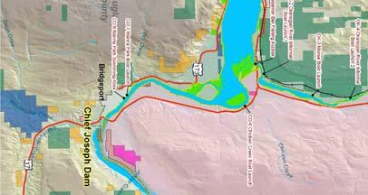
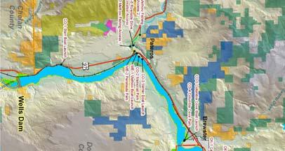
5 French Creek Benson Creek Hoo ker Creek Chiliwist Creek 3 97 French Creek Okanogan County W hitestone Creek Okanogan R iver Colville Indian Reservation Swamp Creek OK-4 Okanogan River Informal Boat Launch 2 OK-3 Monse Boat Launch CO-4 Columbia Cove Park Brewster CO-5 Columbia Cove Boat Launch OK-2 Okanogan River Informal Boat Launch 1 OK-1 Cassimer Bar Fishing Access Col umbia R Chicken Cre e k CO-6 Chicken Creek Boat Launch iver Met how River ME-4 Methow Fishing Access 2 ME-5 Riverside Drive Recreation Access ME-3 Methow Fishing Access 1 Pateros CO-3 Winter Boat Launch CO-2 Memorial Park ME-1 Methow Boat Launch ME-2 Peninsula Park 173 Dry Creek CO-7 Marina Park Boat Launch 97 Douglas County CO-8 Marina Park Swimming Area Bridgeport CO-1 Starr Boat Launch Jordan Creek Chief Joseph Dam Antoine Creek Chelan County T-1 Carpenter Island Informal Boat Launch Wells Dam Smith Draw West Foster Creek East F oster Creek 17 Whatcom San Juan Okanogan Pend Oreille Skagit Ferry Island Clallam Snohomish Stevens Chelan Jefferson Kitsap Douglas Spokane Lincoln King Mason I-90 I-405 Grays Harbor Kittitas Grant Pierce Thurston Adams Whitman Pacific Lewis Franklin Garfield Yakima Wahkiakum I-5 Columbia Cowlitz Benton Walla Walla Asotin Skamania I-82 Klickitat Clark I-205 Wells Hydroelectric Project Public Access Study - Study Sites 230kV Transmission Line Dams Railroad Project Boundary State Routes Bureau of Land Management Counties Cities US Army Corps of Engineers US Dept. of Defense US Forest Service Washington Dept. of Fish and Wildlife Washington State Parks Douglas PUD Washington Dept. of Natural Resources Colville Reservation Miles Notes: 1. The locations of all features shown are approximate. 2. This drawing is for information purposes. Douglas PUD can not guarantee the accuracy and content of this map.
6 4 METHODOLOGY Evaluate Access Related to Reservoir Fluctuations To evaluate access related to reservoir fluctuations, the steps described below were performed: A headwater duration curve for the years was developed using hourly elevation data from the Wells forebay to determine how often fluctuations occur. A backwater model (HEC-RAS) was used to determine specific elevations at recreation access sites during typical seasonal river flows Depths at boat launches and docks were evaluated to determine at what elevations access sites could become inaccessible due to low water. The effects of substrate buildup on access to the reservoir was evaluated. Reservoir bathymetry data were used to identify potential shallow areas in order to evaluate how reservoir fluctuations may affect on-water boating experiences. Evaluate Access Related to Aquatic Plants To evaluate access related to aquatic plants, the steps described below were performed: A field survey was conducted to map the extent of any aquatic weed growth using hand-held GPS equipment and detailed aerial photo imagery to establish general locations of aquatic plants near the sites. Plant identification was accomplished using a line and grapple. In areas where aquatic plants were determined to be potentially restricting access to the Wells Reservoir, potential options to improve access were identified and described.
7 5 Results Headwater Duration Curve The headwater duration curve demonstrates that the reservoir is operated for a vast majority of the time above El. 775 with over 95 percent of its operations above El. 778 and 50 percent of its operations above El Wells Reservoir (Lake Pateros) (5 Years) 100% 90% 80% Percent of Time at or Above 70% 60% 50% 40% 30% 20% 10% 0% Elevation Above Mean Sea Level (at Wells Dam Forebay) Boat Launch Evaluation Criteria Boat Launch/Dock Site Access Evaluation Criteria Criteria Description Criteria Preferred Ramp Slope percent 3 feet above the toe of the hardened (concrete) ramp Minimum Launch Depth surface and 4 feet above channel bottom (boats up to 26 feet in length) Minimum Channel Depth 4 feet (boats up to 26 feet in length) Minimum Channel Width 50 feet (at 5 mph) (California Dept. of Boating and Waterways, 1991; and COE, 2004; and Ohio DNR, 2003)
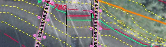
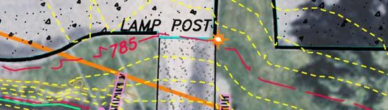
8 6 785 LEGEND: WS 781 WS 780 WS 779 WS 773 WS BREWSTER BRIDGE Elevation (ft) STARR BOAT LAUNCH CITY OF PATEROS MEMORIAL PARK WINTER BOAT LAUNCH CITY OF BREWSTER COLUMBIA COVE PARK SWIMMING CITY OF BRIDGEPORT MARINA PARK Approx. River Mile (mi) BACKWATER CURVES COLUMBIA RIVER - JULY FLOWS FIGURE C-2


9 7
10 8 Summary of the site access evaluations as related to reservoir fluctuations. Site Designation Summary - Site Access at Various Wells Reservoir Elevations Site Description Wells Dam Forebay Elevation Below Which Site Access is Negatively Impacted (For Average Flows Except as Noted) Percentage of Time Wells Forebay Above Elevation Columbia River Sites CO-1 Starr Boat Launch El % CO-2 City of Pateros Memorial Park (Docks) No access restrictions at ends of docks 100 % CO-3 Winter Boat Launch El % CO-4 CO-5 City of Brewster Columbia Cove Park (Dock and Swimming Area) City of Brewster Columbia Cove Park (Boat Launch) Dock No access restrictions El Swimming area 100 % 99 % El % CO-6 Chicken Creek Boat Launch Not Applicable Fluctuations in reservoir do not directly impact access due to isolation of site from Not Applicable main reservoir. CO-7 City of Bridgeport Marina Park (Boat Launch) El % CO-8 City of Bridgeport Marina Park (Swimming Area) El % Methow River Sites ME-1 Methow Boat Launch El % ME-2 City of Pateros Peninsula Park (Swimming Area) El % ME-3 Methow Fishing Access 1 Reservoir fluctuations do not negatively impact access. Not Applicable ME-4 Methow Fishing Access 2 Reservoir fluctuations do not negatively impact access. Not Applicable Riverside Drive Recreation ME-5 Access (At Tennis Courts, North Side of River) Okanogan River Sites OK-1 OK-2 OK-3 OK-4 Cassimer Bar Fishing Access Okanogan River Informal Boat Launch 1 Monse Boat Launch Okanogan River Informal Boat Launch 2 Reservoir fluctuations do not negatively impact access. Reservoir fluctuations do not negatively impact access. Not Applicable Not Applicable El % El. 780 (Average Seasonal Flow) El (Low Seasonal Flow) El. 773 (Average Seasonal Flow) El (Low Seasonal Flow) 35 % 8 % 99 % 98 %
11 9 Evaluation of Access Related to Substrate Buildup Substrate buildup was observed at three of the reservoir study sites: ME-1 (Methow boat launch), OK-3 (Monse boat launch), and CO-5 (Columbia Cove boat launch). At both the Methow and the Monse boat launches, the buildup of sediments in the ramp area from upstream bed load movement is reducing access to the ramp. At the Methow Launch, a bar has formed over the years between the launch and the main channel of the Methow River. At the Monse launch, the eddy caused by the bridge abutment deposits bed load in the launch area. It is difficult to estimate the deposition rate at these sites without further study, but a considerable amount of bed load moves down both the Methow and Okanogan rivers contributing to these problems. At the Columbia Cove launch, rocks have deposited on the ramp making launching more difficult at low reservoir levels. Evaluation of Access Related to Reservoir Fluctuations Shallow Areas A complete set of maps identifying areas of shallow, medium, and deep areas was developed. Reservoir fluctuations occur without warning. Boaters should exercise caution when boating on the reservoir. Recommendations include signage at boat launches educating boaters of potential reservoir fluctuations.
 MODERATE DEPTH (15-25 ft) DEEP")


12 ³ 10 PLATE B17!( Brewster CO-4 Columbia Cove Park CO-5 Columbia Cove Boat Launch!( BOAT ACCESSIBILITY SHALLOW WATER (0-15 ft) MODERATE DEPTH (15-25 ft) DEEP WATER (>25 ft) EXPLANATION!C RIVER MILE!( PROJECT FEATURES STATE ROUTES STREAMS-RIVERS CITIES PROJECT BOUNDARY 173 Reference surface elevation is 781 ft (NGVD29) Miles inch equals 0.1 miles P:\1\ \03\GIS\MapBooks\ShallowZones\ _ShallowZones.mxd Map Revised 07/30/ !C μ Notes: 1. The locations of all features shown are approximate. 2. This drawing is for information purposes. Douglas PUD #1 can not guarantee the accuracy and content of this map. 3. It is unlawful to copy or reproduce all or any part of this document whether for personal use or resale, without permission of Douglas PUD #1.
13 11 Evaluate Access Related to Aquatic Plants Evaluation of Access at Sites Related to Aquatic Plants In general, most of the substantial plant growths observed during the June survey were low growing and sparse, and thus unlikely to have any significant impacts on public access. Summary - Site Access at Various Wells Reservoir Elevations Site Designation Site Description Plant growth observed Proportion of Eurasian water milfoil Columbia River Sites Native Access not restricted Low CO-1 Starr Boat Launch immediately at the launch. Moderate restriction at approach to/from launch. CO-2 City of Pateros Memorial Park Low Native No restriction (Docks) CO-3 Winter Boat Launch Non-native No restriction High CO-4 CO-5 City of Brewster Columbia Cove Park (Dock and Swimming Area) City of Brewster Columbia Cove Park (Boat Launch) Dock Area: Native No restriction Swimming Area: No restriction Native No restriction CO-6 Chicken Creek Boat Launch Not assessed, non-motorized access only. Not Applicable CO-7 City of Bridgeport Marina Park (Boat Launch) Non-native No restriction High CO-8 City of Bridgeport Marina Park (Swimming Area) Native - Restricted Low Methow River Sites ME-1 Methow Boat Launch Native No restriction Low ME-2 City of Pateros Peninsula Park Native No restriction Low ME-3 Methow Fishing Access 1 (South Side of River) Native No restriction Low ME-4 Methow Fishing Access 2 (North Side of River) ME-5 Riverside Drive Recreation Access Okanogan River Sites No plant growth (main channel of Methow River) No restriction Native No restriction OK-1 Cassimer Bar Fishing Access Native Moderate restriction (fishing) Low OK-2 Okanogan River Informal Boat Launch 1 Native No restriction Low OK-3 Monse Boat Launch Native No restriction Low OK-4 Okanogan River Informal Boat Launch 2 Native No restriction Low Low Low Low
14 WELLS RECREATION NEEDS ASSESSMENT INTERIM STUDY REPORT FINDINGS SUMMARY I. STUDY OBJECTIVES August 22, 2008 Objective 1. Objective 2. Objective 3. Objective 4. Objective 5. Objective 6. Summarizing prior study findings to evaluate recreational use and demand within the Wells Project. This summary was based on results of the 2005 Wells Project Recreation Visitor Use Assessment, existing information from FERC Form 80s for the Wells Project, Interagency Committee for Outdoor Recreation outdoor recreation participation survey, WDFW fisherman surveys, WDFW hunter surveys, City of Bridgeport's Marina Park surveys, and other relevant recreational information. Assessing the needs of Hispanic use of recreational facilities and resource areas. Assessing the adequacy of existing recreation facilities at the Wells Project to accommodate current and future recreation demand. Assessing the adequacy of public access at Wells Project recreation facilities. Assessing the adequacy of facility maintenance at Wells Project recreation sites. Developing a prioritized list of potential actions to address Wells Project recreation needs. The list included criteria such as demand, effectiveness, feasibility, and cost. II. ASSESSMENT OF UNMET DEMAND (Objective 1) Reviewed 2002 SCORP o High latent demand relative to Wells Project recreation Walking and hiking Nature activities Sightseeing Bike riding Picnicking Water activities Fishing Camping Hunting Based on visitor comments, the most common activities reported by respondents in the Wells Project 2005 visitor survey were: Fishing (bank, dock, jetty) Boating/Swimming/Water Activities Hiking/Walking Picnicking Page 1 of 7
15 Camping Enhancement recommendations by the Interagency Committee for Outdoor Recreation (Recreation & Conservation Office): o Trails and paths for walking and biking o Manage dispersed shoreline camping o Improve access for water recreation o Improve opportunities for non-consumptive interaction with nature including fish and wildlife. Wells Project Visitors (Objective 1, 3, 4, 5): o Majority felt no other activities or services needed to be offered (62 percent) o Less than 50% felt that changes were needed Areas emphasized for change included improving or adding facilities such as picnic areas, restrooms, and boat launches o 75% felt directional and information signs and interpretive opportunities were adequate o Visitors generally satisfied with their experience, overall found minimal current unmet recreational demand Community Use Summary (Objectives 1, 2, 3, 4, 5): Brewster: o Majority of respondents used RV Campground, boat ramp, playground o Most popular activities were swimming and fishing o Trash identified by 4 respondents o Some indication of some signage needed in Spanish o Some indication of increased security/lighting at facilities Bridgeport: o Playground was the most utilized facility, followed by the trail and overlook o Responses were mixed regarding more educational information and the availability of information o Most popular activities were swimming and fishing o Individual comments regarding activities included the following: Attract visitors with fishing tournaments Facility is good and very helpful to promote family activities Unpredictable water levels Better bathroom facilities More areas for hiking More surveillance More information about maintaining the areas clean Signage stating not to throw garbage and to care Use the fish hatchery on the river in Bridgeport, Increase the bathroom facilities Build sidewalks along the banks of the river at marina park Signs not adequate for people driving Spread the facilities that are in Bridgeport, have edu. programs in schools Raise awareness of Bridgeport and all its resource More information in Spanish Spot Count Observations (Objectives 3, 4): Page 2 of 7
16 o Highest on weekends and holidays; exceptional high use during opening day fishing at boat launches; o Vast majority of estimated recreation use occurred during the peak season, May- September, occurred at Bridgeport Marina Park (30 percent of Wells estimated visitation); o Brewster Columbia Cove Park received the next highest estimated visitation. *Summary of Fish and Game: still working on this (Objective 3, 4). Summary of Hispanic Recreation Literature Review (Objective 2): Recreate in larger family groups Place high value on social qualities of their recreation experience Swimming highly important Utilize outdoor cooking facilities Focus should be on opportunities to hike, camp, participate in recreation near bodies of water Information from family and friends, print media Sensitive to fees Summary of high unmet demand (Objectives 3, 4, 5): Improved fishing access on the Okanagan River access, improved fishing/boating; may lessen access burden on the Brewster access for boat fishing during peak times Improved restroom facilities and picnic areas to meet interest of different cultural groups III. FUTURE RECREATION DEMAND (Objective 3) Reviewed trends: WDFW fishing survey o Fish for relaxation, to be with family and friends, sport, fun o Trout and salmon popular species o Salmon anglers spend more per trip Washington Fishing License sales o On the rise over the past three years statewide, relatively stable in Okanogan, Douglas and Chelan counties Washington Guide Activity o 10 outfitters operating within Okanogan, Chelan, and Douglas counties; 6 focus on guided fishing trips o 9 outfitters a multitude of experiences o 9 whitewater rafting outfitters o Slight growth since 2005, 466 to 501 in state ORV Green Sticker Sales o ORV use and growth will likely continue, however may be tempered by the increased fuel costs Boating Vessel Trends o Relatively stable, will be interesting to see the impact of fuel costs Great Washington State Birding Trail Page 3 of 7
17 o Appears to be interest with 64,500 maps distributed for this location. Results of survey not completed to date Outdoor Industry of America 2007 Results o Human powered outdoor recreation (camping, biking, trail, and paddle) are important financially to the State of Washington Estimate of Future Use (Objective 3) Focused on the population growth of Chelan, Okanagan, and Douglas counties, with some reference to Seattle area. Motorboating (wakeboarding / waterskiing) may increase in popularity but could be tempered by escalating fuel costs; motorboating activities were identified by 9 percent of the visitors to the Wells Project Fishing may increase 7 to 36 percent depending on population growth The Greater Columbia River Water Trail, may influence the type of activities taking place on the Wells Reservoir. Presently, very little activity in paddle sports was observed. However, with the advent of the water trail and publicity, as well as increased fuel costs, paddle sports may increase in this area as they have done in other areas of the state. IV. REGIONAL UNIQUENESS AND SIGNIFICANCE (Objective 3) Destination camping areas within a ten mile radius of the Wells Project area, that are not associated with the Wells Project include: o Alta Lake State Park o Bridgeport State Park Day use area: o Fort Okanagan State Park Regional recreational opportunities exist that offer fishing, boating, swimming, camping, picnicking and hiking What is unique in the region regarding the Wells Recreation opportunities? The availability of low-density experiences V. PUBLIC ACCESS ANALYSIS (Objective 4) Facilities Evaluation All of the recreation facilities and sites are within the FERC Wells Project Boundary; and most of the facilities are either located on Douglas PUD land or lands associated with towns and cities along the Wells Reservoir. Despite varying entities that operate and maintain the Wells Project recreation facilities, all of the facilities should be subject to the same level of routine, day-to-day maintenance activities. Routine maintenance is considered short-term maintenance activities and defined as repair, prevention, and cyclic maintenance, as compared to long-term maintenance (replacement and rehabilitation of facilities). Routine maintenance is discussed below by shortterm and annual maintenance. The following Tables (1 & 2) outline the key types of routine maintenance that should be undertaken at each facility (depending upon the site amenities offered at each location). Page 4 of 7
18 Operations and Maintenance Recommendations (Objective 5) Table 1. Routine Short-Term Maintenance Recommendations for the Wells Project Recreation Facilities. SHORT-TERM MAINTENANCE (includes those activities that occur on almost a daily or weekly basis, and are the responsibility of Operator) Utilities - Maintenance of all utilities (water, septic system, garbage removal, propane, etc.). Cleaning - Operator shall clean all Facilities regularly in accordance with accepted site cleaning practices. Vandalism - Graffiti or signs placed by the public will be removed and the Facilities restored by Operator at its cost within one week after Operator becomes aware of the graffiti. Operator shall take reasonable measures to prevent vandalism in the Facilities. Other Minor Short-term Maintenance - Operator shall perform all minor maintenance work on an as-needed basis. Such duties shall include, but not be limited to: replacing leaky and broken bathroom fixtures; applying disinfectant and deodorants in toilets; straightening sign posts; tightening door hinges; removing all nails, ropes, poles, and wire from trees and Facilities; and straightening and replacing barriers along roadways and spurs, painting picnic tables, cleaning fire pits, cleaning and repair of fish cleaning stations, etc. Boat Handling Docks - Operator shall be responsible for the installation and for removal of the docks. In addition, the moving hardware on boat docks, especially floating docks (e.g. hinges, pins, etc.) that link boat dock sections together should be inspected regularly to ensure safe operation of the docks. Running strips or bumpers around the boat-dock contact points should also be regularly inspected to ensure the parts are all well fastened and functioning properly. Page 5 of 7
19 Table 2. Annual Maintenance Recommendations for the Wells Project Recreation Facilities. ANNUAL MAINTENANCE (includes those activities that are expected to occur on an annual or semi-annual schedule, and are the responsibility of Operator) Equipment - Operator should inspect the conditions of all facilities prior to opening day each year. The facilities included in this provision are: picnic tables; cooking grills; water hydrants; boat docks; benches; fee collection stations; changing rooms; picnic shelters, fire rings; drinking fountains; trash receptacles; signs (entrance, directional, and informational); fish-cleaning stations; lights/lamps (indoor and outdoor); restroom/comfort stations; and playground equipment. Recommended Schedule of Annual Maintenance - Maintenance Activity (Target Date for Action) Straighten all barriers (Prior to Opening day) Paint interior of all restrooms with paint approved (At end of 3 year period) Paint or stain all bulletin boards with paint or stain approved (At end of 3 year period) Paint entrance signs with paint approved (At end of 3 year period) Paint/stain all exterior wood surfaces excluding roofs, of all restrooms with paint or stain approved (At end of 3 year period) Paint all picnic tables with paint approved (At end of 3 year period) Install and remove boat dock (Beginning and end of operating season) Winterize and de-winterize water supply system (Beginning and end of operating season) Pump vault toilets (As needed, but at least at end of operating season) VI. RECREATION ISSUES FOR RESOURCE AREAS (Objectives 2-5) Majority of respondents were satisfied with existing facilities (77 percent); number of improvements recommended was relatively low. Many respondents would prefer to experience a semi-primitive setting. Ninety-one percent enjoyed their trip and expect to come back in the future. The following is a list of improvements suggested by respondents regarding questions relative to facilities. Brewster: Clean bathrooms; interest in full RV hook-up and shade Provision of tent camping sites Expand boat ramp/launch Bridgeport: Expand boat ramp/launch More space at marina Pateros Resource Area: Page 6 of 7
20 Maintenance on toilet/showers ADA compliance Okanagan: Improve boat launch at Monse VII. SUMMARY OF ACTIONS TO ADDRESS PROJECT-RELATED ISSUES (Objective 6) Operations and maintenance as described above Adapt or reconstruct facilities at the end of their useful life to meet ADA standards for accessibility, including picnic tables, restrooms, boat launch access, and parking areas Consider the development of the Columbia River Water Trail in the provision of easy access and tent camping for non-motorized paddling; support via signage and information. Consider unique cultural recreation needs, including signage and the provision of greater picnic facilities for increased family group size. Consider boat access improvement on the Okanagan River which may alleviate crowding at certain times of the year at the Brewster boat launch. Monitor trends via the FERC Form 80 reporting to identify emerging uses as a result of the water trail or other influences on the economy. Page 7 of 7
RECREATION MANAGEMENT PLAN WELLS HYDROELECTRIC PROJECT FERC NO. 2149
 RECREATION MANAGEMENT PLAN WELLS HYDROELECTRIC PROJECT FERC NO. 2149 May 2010 Prepared by: Public Utility District No. 1 of Douglas County Copyright 2010. Public Utility District No. 1 of Douglas County.
Prescription Opiates and Heroin - Skamania County
 Opiate Related Deaths (Prescription and/or Heroin) by County of Residence, 2008-2010 County 3 yr count 2008-2010 Average annual rate per 100,000 Clallam 25 11.7 Spokane 142 10.1 Cowlitz 28 9.2 Ferry-Pend
Formstack Submission For: RCW : General Authority Peace Officer-Powers, Circumstances Submitted at 11/02/17 4:40 PM
 From: To: Subject: Date: noreply@formstack.com Deb Gregory RCW 10.93.070: General Authority Peace r-powers, Circumstances Thursday, November 2, 2017 1:41:08 PM Formstack Submission For: RCW 10.93.070:
PORTS IN WASHINGTON STATE
 PORTS IN WASHINGTON STATE New Market Industrial Campus and Tumwater Town Center Real Estate Development Master Plan Public Meeting #1 March 5, 2015 Founded in 2005, Community Attributes Inc. (CAI) tells
2018 MEDIA KIT CAPITAL PRESS. Frequency Weekly (Friday) Circulation 27,479. In-State Editors 2. ROP Splits Pre-Set Zones Pacific Inland
 Circulation 27,479. In-State Editors 2. ROP Splits Pre-Set Zones Pacific Inland") 2018 MEDIA KIT CAPITAL PRESS Frequency Weekly (Friday) Circulation In-State Editors 2 ROP Splits Pre-Set Zones Pacific Inland Insert Splits Pre-Set Zones County Adams Clackamas Lane Douglas Curry Coos
2018 MEDIA KIT CAPITAL PRESS Frequency Weekly (Friday) Circulation In-State Editors 2 ROP Splits Pre-Set Zones Pacific Inland Insert Splits Pre-Set Zones County Adams Clackamas Lane Douglas Curry Coos
The Washington DA List
 Andrew K. Miller Benton County 7122 W. Okanogan Place Kennewick, WA 99336 Phone (509) 735-3591 Fax (509) 736-3066 Arthur D. Curtis Clark County P.O. Box 5000 Vancouver, WA 98666 Phone (360) 397-2016 Fax
THE 2007 RECREATION ACTION PLAN WAS FILED WITH THE FEDERAL ENERGY REGULATION COMMISSION (FERC) ON DECEMBER 26, 2007 AND IS AWAITING APPROVAL.
 ON DECEMBER 26, 2007 AND IS AWAITING APPROVAL.") THE 2007 RECREATION ACTION PLAN WAS FILED WITH THE FEDERAL ENERGY REGULATION COMMISSION (FERC) ON DECEMBER 26, 2007 AND IS AWAITING APPROVAL. UPON APPROVAL, PUBLIC UTILITY DISTRICT NO. 1 OF DOUGLAS COUNTY
THE 2007 RECREATION ACTION PLAN WAS FILED WITH THE FEDERAL ENERGY REGULATION COMMISSION (FERC) ON DECEMBER 26, 2007 AND IS AWAITING APPROVAL. UPON APPROVAL, PUBLIC UTILITY DISTRICT NO. 1 OF DOUGLAS COUNTY
International Osoyoos Lake Board of Control Annual Report to the International Joint Commission
 International Osoyoos Lake Board of Control 2013 Annual Report to the International Joint Commission TABLE OF CONTENTS ACTIVITIES OF THE BOARD... 1 HYDROLOGIC CONDITIONS IN 2013... 2 Drought Criteria...
DRAFT FINAL ACCESSIBILITY GUIDELINES FOR OUTDOOR DEVELOPED AREAS
 Date: October 19, 2009 DRAFT FINAL ACCESSIBILITY GUIDELINES FOR OUTDOOR DEVELOPED AREAS Introduction Background Whom Guidelines Apply To How to Submit Comments Contact for Further Information General Issues:
Wallowa Falls Hydroelectric Project FERC Project No. P-308 Proposed Study Plans - Recreation August 2011
 Wallowa Falls Hydroelectric Project FERC Project No. P-308 August 2011 Prepared by: PacifiCorp Energy Hydro Resources 825 NE Multnomah, Suite 1500 Portland, OR 97232 For Public Review Wallowa Falls Hydroelectric
Domestic Violence Fatalities in Washington State
 2013 Domestic Violence Fatalities in Washington State In 2013, 35 people died in Washington State as a result of domestic violence. These deaths include 16 women and 1 man killed by partners and ex-partners;
SAXON HARBOR REDEVELOPMENT SURVEY
 SAXON HARBOR REDEVELOPMENT SURVEY SEPTEMBER, 2016 1,173 RESPONSES 1 BACKGROUND 1. WHAT TYPES OF ACTIVITIES DO YOU ENGAGE IN AT SAXON HARBOR Sightseeing Swimming Picnicing Fishing Camping Photography Motorized
Understanding the caring capacity of the visitor experience Provide facilities to support a high level user experience Address visual quality through
 Understanding the caring capacity of the visitor experience Provide facilities to support a high level user experience Address visual quality through recreation ecological restoration opportunities Collaboration
Camping (Primitive) Camping (RV) Electrical Potable Water Grill Established Fire Pit Picnic Table
 Camping (RV) Electrical Potable Water Grill Established Fire Pit Picnic Table") Alden - 9th Road River Mile 777 Map: 38.20833, -98.32031 Managing Agency: Kansas Department of Wildlife, Parks & Tourism Nearest Community: Alden, Rice County Kansas Developed Amenities Provided Parking
Alden - 9th Road River Mile 777 Map: 38.20833, -98.32031 Managing Agency: Kansas Department of Wildlife, Parks & Tourism Nearest Community: Alden, Rice County Kansas Developed Amenities Provided Parking
Outdoor Developed Areas
 The United States Access Board is an independent federal agency that promotes equality for people with disabilities through leadership in accessible design and the development of accessibility guidelines
What s covered. What s not covered. Options for those not covered. ABA Coverage
 The United States Access Board is an independent federal agency that promotes equality for people with disabilities through leadership in accessible design and the development of accessibility guidelines
Preferred Recreation Recommendations Stemilt-Squilchuck Recreation Plan March 2018
 Preferred Recreation Recommendations Stemilt-Squilchuck Recreation Plan March 2018 Below are the recommended recreation ideas and strategies that package together the various recreation concepts compiled
Rogue River Access and Management Plan Draft Alternatives
 Rogue River Access and Management Plan Draft Alternatives The Rogue River Access and Management Plan was initiated in December, 2011 and is being led by Jackson County Parks (JCP) and Oregon Department
TABLE OF CONTENTS LIST OF TABLES NONE LIST OF FIGURES NONE
 PacifiCorp / Cowlitz PUD FERC Project Nos. 935, 2071, 2111, 2213 TABLE OF CONTENTS 7.2 RECREATION DEMAND ANALYSIS (REC 2)... REC 2-1 7.2.1 Study Objectives... REC 2-1 7.2.2 Study Area... REC 2-1 7.2.3
Lake Red Rock Volunteer Service Opportunities Season
 Lake Red Rock Volunteer Service Opportunities - 2015 Season A detailed description of volunteer duties relating to each position is available upon request. Requirements of all positions: 1. Available to
Appalachian Power Company Smith Mountain Hydroelectric Project FERC No Debris Management Plan
 Appalachian Power Company Smith Mountain Hydroelectric Project FERC No. 2210 Debris Management Plan Final July2008 TABLE OF CONTENTS Description Page SUMMARY 1 1.0 Introduction.. 2 1.1 Project Lands and
Parks & Recreation Areas Program
 PARKS & RECREATION Parks & Recreation Areas Program As part of its mission to conserve and protect natural resources, the Upper Big Blue Natural Resources District (NRD) has been involved in several large-scale
Proposed Action Kaibab Campground Capital Improvement Project September 2008
 Background Kaibab Campground Capital Improvement Project September 2008 The Williams Ranger District of the Kaibab National Forest is proposing to improve the Kaibab Lake Campground. Kaibab Lake Campground
Summary of Recreation Sites Development Name:
 Development Name: Eau Pleine Site Number: 1 Owner: WVIC Eau Pleine Tailwater Boat Launch Lanes 1 Concrete plank landing, access to Eau Pleine tailwater & Lake DuBay. (45 planks long, 62.5') Picnic Tables
 CEMVP-PD-C MEMORANDUM FOR FILE SUBJECT: Supplement No. 4,, Design Memorandum 10, Kaskaskia River, Illinois 1. References: a., Design Memorandum No. 10, approved 1997 (includes Supplements 1-3) b. ER 1130-2-550,
DRAFT RECREATION RESOURCE MANAGEMENT PLAN
 DRAFT RECREATION RESOURCE MANAGEMENT PLAN FERC Project Nos. 935, 2071 and 2111 Prepared by: EDAW, Inc. Seattle, Washington and PacifiCorp Portland, Oregon April 2004 EXECUTIVE SUMMARY PacifiCorp FERC
Flow Stand Up Paddle Board Parkway Plan Analysis
 Regional Parks Department Jeffrey R. Leatherman, Director County of Sacramento Divisions Administration Golf Leisure Services Maintenance Rangers Therapeutic Recreation Services Flow Stand Up Paddle Board
BUCKEYE LAKE PROTECTION PLAN THE TOWN OF BEECH MOUNTAIN REGULATIONS GOVERNING IN-LAKE ACTIVITIES AND USES OF BUCKEYE LAKE
 I. PURPOSE BUCKEYE LAKE PROTECTION PLAN THE TOWN OF BEECH MOUNTAIN REGULATIONS GOVERNING IN-LAKE ACTIVITIES AND USES OF BUCKEYE LAKE The purpose of this regulation is to set forth for the Town of Beech
O REGON TRAILS SUMMIT. Oregon Trails Summit. Rogue River National Forest
 O REGON TRAILS SUMMIT Oregon Trails Summit 2014 Rogue River National Forest OREGON TRAILS 2015: A VISION FOR THE FUTURE The 2015-2024 Oregon Statewide Trails Plan Why do a trails plan? 2005-2014 Oregon
Okanogan Borderlands Historical Society : ;:!
 Okanogan Borderlands Historical Society : ;:! 1210 Ironwood Street Orovllle, WA 98844 ~.'.'.-f:'e~i'" "k :... November 18, 2008 Kimberly D. Bose, Secretary Federal Energy Regulatory Commission 888 First
Enduris Members 4Culture Adams Conservation District Adams County FPD #6 Adams County Mosquito Control District Adams County Noxious Weed Board Adams
 Enduris Members 4Culture Adams Conservation District Adams County FPD #6 Adams County Mosquito Control District Adams County Noxious Weed Board Adams County Park & Rec Board #2 Adams County Park & Recreation
Lake Tahoe Shoreline Plan 03 Policy Topic: Access Issues
 Lake Tahoe Shoreline Plan 03 Policy Topic: Access Issues V9 Last Updated 03.10.2017 1 Brief Description Physical access to the waters of Lake Tahoe is one of the key issues surrounding the Shoreline Plan
Androscoggin River Trail Access Sites. North Woods. 168 miles from its source at Lake Umbagog to Merrymeeting Bay
 Androscoggin River Trail Access Sites North Woods 168 miles from its source at Lake Umbagog to Merrymeeting Bay Trail Under Construction More than 40 Public Access Sites Available Androscoggin River Watershed
APPENDIX A PARKS AND RECREATION FACILITY INVENTORY
 APPENDIX A PARKS AND RECREATION FACILITY INVENTORY Okanogan County Parks Okanogan County Sa Teak Wa River trail Okanogan County Similkameen Trail River trail Okanogan County Fair Grounds Okanogan County
Proposal to Redevelop Lower Kananaskis River-Barrier Lake. Bow Valley Provincial Park. Frequently Asked Questions
 Proposal to Redevelop Lower Kananaskis River-Barrier Lake Bow Valley Provincial Park Frequently Asked Questions What is being proposed? What are the details of the proposal? Where is the project area located?
Terrestrial Resource Work Group
 Terrestrial Resource Work Group Date: February 6, 2007 Time: Location: 9:00 am 3:00 pm Douglas PUD Directions Sign In Sheet Agenda Meeting Notes Directions to Douglas PUD Douglas PUD 1151 Valley Mall Parkway
A Vision for South Skunk River and Chichaqua Bottoms Greenbelt
 A Vision for South Skunk River and Chichaqua Bottoms Greenbelt Photo: Jim Pease Chichaqua Bottoms Booklet 7 of 8 Greater Des Moines Water Trails and Greenways 1 2016 Table of Contents Booklet 1: Water
International Osoyoos Lake Board of Control Annual Report to the International Joint Commission
 International Osoyoos Lake Board of Control 2010 Annual Report to the International Joint Commission TABLE OF CONTENTS ACTIVITIES OF THE BOARD... 1 HYDROLOGIC CONDITIONS IN 2010... 2 Drought Criteria...
Appendix C Oregon Resident Component of Recreation Visitor Survey Results
 Appendix C Oregon Resident Component of Recreation Visitor Survey Results Oregon Resident Component of Recreation Visitor Survey Results Lewis River Hydroelectric Projects FERC Nos. 2111, 2213, 2071, and
Fossil Creek Wild & Scenic River Comprehensive River Management Plan Forest Service Proposed Action - details March 28, 2011
 Fossil Creek Wild & Scenic River Comprehensive River Management Plan Forest Service Proposed Action - details March 28, 2011 Primary Goals of the Proposed Action 1. Maintain or enhance ORVs primarily by
DRAFT. Dorabelle Campground Rehabilitation
 DRAFT Dorabelle Campground Rehabilitation September 2012 1.1 REGIONAL SETTING AND PROJECT LOCATION The Dorabelle Campground is located on the western shore of Shaver Lake in Fresno County, California (Section
Lake Myra County Park. Wake County, North Carolina Community Forum #2 June 12, 2008
 Lake Myra County Park Wake County, North Carolina Community Forum #2 June 12, 2008 Welcome and Introduction Meeting Agenda Welcome Introductions of Project Team Master Plan Process Community Forum #1 Updates
b. Minimum Site Area. Recreational vehicle parks shall be located on a parcel of land not less than 3 acres in area.
 6450 RECREATIONAL VEHICLE PARK REGULATIONS 6450 TITLE AND PURPOSE. The provisions of Section 6450 through 6499, inclusive, shall be known as the Recreational Vehicle Park Regulations. The purpose of these
AVISTA CORPORATION SPOKANE RIVER AND POST FALLS HYDROELECTRIC DEVELOPMENTS RECREATION PLAN. Spokane River Hydroelectric Project FERC Project No.
 AVISTA CORPORATION SPOKANE RIVER AND POST FALLS HYDROELECTRIC DEVELOPMENTS RECREATION PLAN FERC LICENSE ARTICLES 416 & 417 Spokane River Hydroelectric Project FERC Project No. 2545 Prepared by: REC Resources
Picnic Units A picnic unit is a part of a picnic area
 Grab Bars Grab bars are usually provided in buildings to provide stability and allow a person to use his or her arms to assist in movement over short distances. The most common location for grab bars is
Group similar facilities together separate dissimilar facilities.
 Park design Principle #1 Group similar facilities together separate dissimilar facilities. Why do we do this? Safety Differences in admission fees Differences in seasonal use Reduce user conflicts Principle
Section XIII. Cost Estimates
 Section XIII Cost Estimates 13-01. INTRODUCTION SECTION XIII COST ESTIMATES a. General. Preliminary cost estimates for development of proposed new and renovation or replacement actions at Lake Shelbyville
Small Business Earthquake CAT Document
 Small Business Earthquake CAT Document The below guidelines are coded in the system. If you have any questions specific to earthquake during the application, please contact your Small Business Underwriter.
Pillar Park. Management Plan
 Pillar Park Management Plan January 2014 Pillar Park Management Plan Approved by: Jeff Leahy Regional Director Thompson Cariboo Region BC Parks January 9, 2014 Date Brian Bawtinheimer Executive Director
4.0 Context for the Crossing Project
 4.0 Context for the Crossing Project This section provides background information about key features of the North Douglas Crossing project area, and opportunities and constraints. This information is important
Chapter 9 Recreation
 Chapter 9 Chapter 9 1.0 INTRODUCTION The Town of Littleton is within one of New England s most important recreation areas. More than three million people live within 100 miles of the area. Local residents
Welcome to the future of Terwillegar Park a Unique Natural Park
 Welcome to the future of Terwillegar Park a Unique Natural Park 1 Introduction The Terwillegar Park Concept Plan study will develop an overall concept plan, management objectives and development guidelines
10/25/2013. What is the SCORP?! 2013 Local Government Survey 2013 Statewide Public Survey Advisory Group Priority Areas Your Suggestions!
 COLORADO OUTDOOR RECREATION TRENDS RESULTS FROM THE SCORP AND STATEWIDE Colorado Outdoor Recreation Resource Partnership September 2013 PRESENTATION What is the SCORP?! 2013 Local Government Survey 2013
Lewis River Recreation Sites
 Lewis River Recreation Sites Parking Fees Hours Visitors entering day-use sites with vehicles must pay applicable fees during peak recreation season. * Pass holders, please check in with booth attendant
Lake Chelan Operations
 Lake Chelan Operations IPMA Executive Seminar September 17, 2013 Presented by: Janet Jaspers Chelan County PUD Lake Chelan Hydroelectric Project Today s Discussion Chelan PUD Overview Interesting Facts
GREENWOOD VEGETATION MANAGEMENT
 APPENDIX G GREENWOOD VEGETATION MANAGEMENT PROJECT RECREATION RESOURCE REPORT Prepared by: Laurie A. Smith Supervisory Forester Stearns Ranger District Daniel Boone National Forest August 4, 2016 The
Susitna-Watana Hydroelectric Project (FERC No ) Recreation Resources Study Study Plan Section Study Implementation Report
 Recreation Resources Study Study Plan Section Study Implementation Report") (FERC No. 14241) Recreation Resources Study Study Plan Section 12.5 2014 Study Implementation Report Prepared for Prepared by AECOM November 2015 TABLE OF CONTENTS 1. Introduction... 4 2. Study Objectives...
(FERC No. 14241) Recreation Resources Study Study Plan Section 12.5 2014 Study Implementation Report Prepared for Prepared by AECOM November 2015 TABLE OF CONTENTS 1. Introduction... 4 2. Study Objectives...
West Point Project U.S. Army Corps of Engineers VOLUNTEER VACANCY ANNOUNCEMENT Posted: 1/12/2018
 West Point Project U.S. Army Corps of Engineers VOLUNTEER VACANCY ANNOUNCEMENT Posted: 1/12/2018 Current Volunteer Coordinator: Park Ranger Rebecca Downey Rebecca.m.downey@usace.army.mil 706-645-6113 West
VOLUME II APPENDIX F DETAILED PHYSICAL DESCRIPTION OF PROJECT RESERVOIRS AND LANDS
 VOLUME II APPENDIX F DETAILED PHYSICAL DESCRIPTION OF PROJECT RESERVOIRS AND LANDS THE CENTRAL NEBRASKA PUBLIC POWER AND IRRIGATION DISTRICT FERC PROJECT NO. 1417 PHYSICAL DESCRIPTION OF PROJECT LANDS
Village of Stockholm
 Village of Stockholm 2016 Plan for the Community Park Park Committee: Harley Cochran Mark Coronna Steve Grams Jerry Larson Hap Palmberg FINAL: FOR VILLAGE BOARD APPROVAL March 8, 2016 1 Table of Contents
Header i
 Header i 048285014.10 Header Sub Title Body Text here. Body text here. Body text here. Section 1... 1 Executive Summary... 1 Opportunities and Constraints... 3 Overall Opportunities and Constraints Map
Silver Lake Park An Environmental Jewel for the Citizens of Prince William County
 Silver Lake Park An Environmental Jewel for the Citizens of Prince William County The Prince William Park Authority Mission Statement states: The Prince William County Park Authority will create quality
Existing Resource Information
 Botanical and Wildlife Vegetation alliances/wildlife habitats Grasslands annual/perennial Chaparral mixed/montane/chamise-redshank Riparian montane/valley foothill riparian Sierran mixed conifer Montane
CHAPTER 4 EXISTING PARKS AND RECREATION FACILITIES INVENTORY
 CHAPTER 4 EXISTING PARKS AND RECREATION FACILITIES INVENTORY Existing park and recreation sites and facilities provide the basis upon which to build a park and recreation plan for the city. This inventory
CHAPTER 5. Chapter 5 Recreation Element
 CHAPTER 5 Recreation Element Chapter 5 Recreation Element The Recreation Element of the Meyers Area Plan is a supplement to the Recreation Element of the TRPA Regional Plan and the El Dorado County General
Crystal Lake Area Trails
 Lake Area Trails Welcome to the Lake area of the Big Snowy Mountains! This island mountain range in central Montana features peaks reaching to 8,600 feet and long, high ridges from which vistas of the
WA DOH Incident Management Team SITUATION REPORT # 2
 WA DOH Incident Management Team SITUATION REPORT # 2 Incident Name: 2017 September Fires 9/6/17 Time: 1600 Phone 360-236-4089 E-mail: doh-sitl@doh.wa.gov I. AFFECTED AREA: States: Washington Counties of
Mountain Valley Pipeline, LLC Mountain Valley Pipeline Project Docket No. CP
 16. Prior to construction, Mountain Valley shall file with the Secretary, for review and approval by the Director of OEP, a segment-specific construction and operation access plan for the area between
Lewis River Recreation Sites
 Lewis River Recreation Sites N 0 miles 2 4 8 Parking Fees Hours Visitors entering day-use sites with vehicles must pay applicable fees during peak recreation season. * Pass holders, please check in with
PURPOSE AND NEED. Introduction
 Public Scoping: Allocation of Recreation Capacity for Commercial Outfitter Guide Services on North Kruzof Island Trails (Kruzof Island Outfitter Guide) PURPOSE AND NEED Introduction The U.S. Department
PARKS & BEACHES PROJECTS
 #18 72ND STREET PARK, LIBRARY, #19 BLUEWAYS & AQUATIC CENTER $1.1 MILLION $60 MILLION New facility to include: Create Kayak Launches with All Wheels Skate Park Floating Docks and Seating at: Library/Media
Accessibility Guidelines for Outdoor Recreation and Trails
 Accessibility Guidelines for Outdoor Recreation and Trails Association of Conservation Engineers September 17, 2007 Accessibility Guidelines for Outdoor Recreation and Trails Access Board is the independent
Kelly Motorized Trails Project Proposed Action
 Kelly Motorized Trails Project Proposed Action November 28, 2011 The Flagstaff Ranger District of the Coconino National Forest is seeking public input on the proposed Kelly Motorized Trails Project (formerly
Potomac River Commuter Ferry Feasibility Study & RPE Results
 1.1 Introduction The Prince William County Department of Transportation conducted a route proving exercise (RPE) and feasibility study of a proposed commuter ferry service on the Potomac River between
Who is Beneficial Designs?
 Who is Beneficial Designs? Beneficial Designs works towards universal access through research, design, and education. We believe all individuals should have access to the physical, intellectual, and spiritual
SPLASH PAD EVALUATION SUMMARY REPORT January 2016
 Public Utility District No. 1 of Chelan County Public Power Benefit Recreation and Parks Phase: Pre-feasibility For full report, refer to Appendix A SPLASH PAD EVALUATION SUMMARY REPORT January 2016 Photo
SIMON CANYON AREA OF CRITICAL ENVIRONMENTAL CONCERN (ACEC)
") SIMON CANYON AREA OF CRITICAL ENVIRONMENTAL CONCERN (ACEC) Activities: Facilities: Season / Hours: Description: Hiking, backpacking, fishing, picnicking, watchable wildlife. A graveled parking area, picnic
SIMON CANYON AREA OF CRITICAL ENVIRONMENTAL CONCERN (ACEC) Activities: Facilities: Season / Hours: Description: Hiking, backpacking, fishing, picnicking, watchable wildlife. A graveled parking area, picnic
Additional Economic Development Strategy submissions- Klickitat County
 Klickitat County Transportation Improvement Projects 1 White Salmon to Hood River Bridge Final EIS, design, bridge replacement 2 Klickitat County Rural Arterials Reconstruct to all-weather roads Part of
Daisy Dean Trail 628/619 ATV Trail Construction
 Background and Purpose and Need The Daisy Dean ATV Trail Construction Project is located in the Little Belt Mountains, Musselshell Ranger District, Lewis and Clark National Forest approximately 32 miles
Appendix D Dispersed/Displaced Recreation Visitor Survey Results
 Appendix D Dispersed/Displaced Recreation Visitor Survey Results Dispersed/Displaced Recreation Visitor Survey Results Lewis River Hydroelectric Projects FERC Nos. 2111, 2213, 2071, and 935 Prepared by:
CHAPTER III: TRAIL DESIGN STANDARDS, SPECIFICATIONS & PERMITS
 CHAPTER III Trail Design Standards, Specifications & Permits This chapter discusses trail standards, preferred surface types for different activities, permits, and other requirements one must consider
Please Tell Us What You Think: Candidate Sites for Recreation Business Activities
 Please Tell Us What You Think: Candidate Sites for Recreation Business Activities Background In January 2015, the Washington State Parks and Recreation Commission (Commission) approved some forms of privately
2017 ASSESSED VALUATIONS USED IN 2019 LOCAL EFFORT ASSISTANCE CALCULATIONS
 ADAMS CO. 01109 Washtucna #109 M&O ADAMS 50,821,206 0 0 50,821,206 01109 Washtucna #312 M&O WHITMAN 1,711,066 0 0 1,711,066 01109 Washtucna #43 M&O FRANKLIN 907,712 0 0 907,712 53,439,984 53,439,984 01122
APPLICATION FOR SITE DEVELOPMENT PLAN LETTER OF INTENT Amended
 Est. 1982 Est. 1982 Urban Planning Community Design Landscape Architecture 731 North Weber Street, Suite 10, Colorado Springs, CO 80903, 719 633-9700 http://www.gumanltd.com/ Members American society of
Federal Outdoor Recreation Trends Effects on Economic Opportunities
 United States Department of Agriculture Federal Outdoor Recreation Trends Effects on Economic Opportunities The Forest Service National Center for Natural Resources Economic Research is assisting the Federal
West Point Lake - Volunteer Openings Summer 2016
 West Point Lake - Volunteer Openings Summer 2016 West Point Lake is surrounded by deep forests and rolling fields extending 35 miles along the Chattahoochee River on the Alabama-Georgia state line. The
Oklahoma RV Parks and Campgrounds
 1 Oklahoma RV Parks and Campgrounds Rolling Stone Stables and RV Park Brief Description: Rolling Stone Stables and RV park is an 80 acre horse farm and RV park. We are located just 2 miles from I-40 for
River Ridge Campgrounds Cabin and RV sites
 River Ridge Campgrounds Cabin and RV sites Hooray!!! The River Ridge Campground at Sprewell Bluff Park is officially open for overnight guests! There are primitive cabins and RV sites for anyone who would
Location: Central Coast, Bella Coola, Cariboo Chilcotin Coast - Provincial : Campground (Discovery Coast Circle Route)
") Mt Robson Visitors Centre Information Date of Audit: 2016-08-26 Park Name: Fisheries Pool Campground Key Features: Camping,Picnic_Site,Beach,Fishing Location: Central Coast, Bella Coola, Cariboo Chilcotin
Mt Robson Visitors Centre Information Date of Audit: 2016-08-26 Park Name: Fisheries Pool Campground Key Features: Camping,Picnic_Site,Beach,Fishing Location: Central Coast, Bella Coola, Cariboo Chilcotin
ROAD AND TRAIL PROJECT APPROVAL
 ROAD AND TRAIL PROJECT APPROVAL www.marincountyparks.org Marin County Parks, 3501 Civic Center Dr, Suite 260, San Rafael, CA 94903 DATE: July 12, 2017 PRESERVE: Gary Giacomini Open Space Preserve PROJECT:
Recreationists on the Gifford Pinchot National Forest: A Survey of User Characteristics, Behaviors, and Attitudes
 Recreationists on the Gifford Pinchot National Forest: A Survey of User Characteristics, Behaviors, and Attitudes by Alan R. Graefe The Pennsylvania State University Robert C. Burns University of Florida
Research Report Agreement T4118, Task 24 HOV Action Plan HOV ACTION PLAN
 Research Report Agreement T4118, Task 24 HOV Action Plan HOV ACTION PLAN by John M. Ishimaru Senior Research Engineer Duane Wright Systems Analyst Programmer Mark E. Hallenbeck Director Jaime Kang Research
Proposal to Redevelop Lower Kananaskis River-Barrier Lake. Bow Valley Provincial Park
 Frequently Asked Questions Proposal to Redevelop Lower Kananaskis River-Barrier Lake Bow Valley Provincial Park Frequently Asked Questions What has been decided? What are the details of the plan? What
DEPARTMENT OF THE ARMY JOINT BASE GARRISON BOX , MAIL STOP 17 JOINT BASE LEWIS-MCCHORD, WA
 REPLY TO ATTENTION OF: DEPARTMENT OF THE ARMY JOINT BASE GARRISON BOX 339500, MAIL STOP 17 JOINT BASE LEWIS-MCCHORD, WA 98433-9500 Public Works Ms. Loree Randall Coastal Zone Management Program Federal
TENKILLER STATE PARK -An Overview-
 TENKILLER STATE PARK -An Overview- - 0 - TENKILLER STATE PARK Region: Northeast (Green Country) Cherokee & Sequoyah Counties CONTENTS General Information. 2 Addresses Driving Directions Phone Numbers Email
WORKING TOGETHER TO ENHANCE AIRPORT OPERATIONAL SAFETY. Ermenando Silva APEX, in Safety Manager ACI, World
 WORKING TOGETHER TO ENHANCE AIRPORT OPERATIONAL SAFETY Ermenando Silva APEX, in Safety Manager ACI, World Aerodrome Manual The aim and objectives of the aerodrome manual and how it is to be used by operating
Wallace Falls State Park Classification and Management Planning Stage 3 Preliminary Recommendations July 18, 2018 Sultan City Hall
 Wallace Falls State Park Classification and Management Planning Stage 3 Preliminary Recommendations July 18, 2018 Sultan City Hall Thanks for coming! This document contains State Parks preliminary recommendations
POLICY DCS-04: Tourism Directional Sign Policy. Development and Cultural Services
 DCS-04 Page 1 of 8 POLICY DCS-04: Tourism Directional Sign Policy Development and Cultural Services Approval Date: March 11, 2008 Approval Authority: Council, Resolution No. 7 Effective Date: March 11,
Saylorville Lake Volunteer Positions 2018
 Saylorville Lake Volunteer Positions 2018 Cleaning Hosts The primary duty of the Cleaning Host is to maintain cleanliness at picnic, campground, and boat ramp areas as outlined below. Park facilities being
Public Park System. Township of Derry. Providing natural open space for the recreational use of our residents and guests.
 Township of Derry Public Park System Providing natural open space for the recreational use of our residents and guests. Directory of Recreational Amenities Hershey s Commitment to Recreation Famous candy