A CONCEPT FOR F.H. BARBER PROVINCIAL PARK.
|
|
|
- Jessie Mervyn Farmer
- 5 years ago
- Views:
Transcription

1 A CONCEPT FOR F.H. BARBER PROVINCIAL PARK.
2 APPROVAL This Concept for F.H. Barber Provincial Park has been reviewed and is approved.
3 Lower Mainland Region Parks and Outdoor Recreation Division Ministry of Lands, Parks and Housing North Vancouver, British Columbia A CONCEPT FOR F. H. BARBER PROVINCIAL PARK Ellen Kavanagh M. H. Turner September, 1979 C. J. Velay Director
4 C. J. Velay J. C. Leman Director Regional Manager Operations Branch Lower Mainland Region Victoria, B. C. North Vancouver, B. C. This Concept for F. H. Barber Provincial Park is submitted for your approval.
5 TABLE OF CONTENTS Page Introduction...1 Historical Development and Recreation Features...3 Concept...6 Zoning...7 Development Proposal...7 Management...9 Summary...9

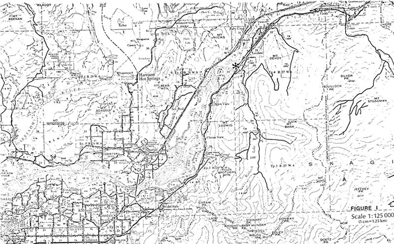
6 1 INTRODUCTION F. H. Barber Provincial Park, 1 kilometre west of Laidlaw, comprises 5 hectares of Fraser River floodplain bordering Jones Creek, the CNR tracks, and the Fraser River (Figure 1). This "Class A" provincial park was established in 1978 and is one of two major public accesses to the Fraser River between Chilliwack and Hope. The park is situated in the Coastal Western Hemlock biogeoclimatic zone with vegetation representative of the undisturbed Fraser floodplain. Black cottonwood, broadleaf maple and red alder are interspersed with red cedar and western hemlock. Salmonberry shrubs form much of the dense understory. Blue jays, chickadees, finches, ravens and eagles are among the many birds that frequent these treed areas along the Fraser River. The river is rich in a variety of fish, including salmon and sturgeon. Semi-precious stones, including agate, jadeite and jasper may be found among the cobbles and boulders deposited along the shoreline. LOOKING EAST FROM GRAVEL BAR TO F. H. BARBER PROVINCIAL PARK
7 2
8 HISTORICAL DEVELOPMENT AND RECREATION FEATURES 3 F. H. Barber "Class A" Provincial Park was established by an Order-In-Council in October, The park is named after Francis Barber, an early settler of the Laidlaw area, whose beneficiaries donated the land to the province. Originally comprising 4 hectares, one hectare of adjacent crown land ham been proposed for addition to the park. Historically, the Laidlaw area ham long been inhabited by the Upper Stalo Indians of the Fraser Valley. Grown-over circular pits, remnants of their semi-subterranean winter homes or "kekulis", can be found around Hunter Creek. Ancestors of kekuli dwellers live in the O'Hamil reserve along the Fraser River, near Laidlaw. The history of the area is linked with the Fraser River. The Fraser was a food source for Indians and a pathway to the goldfields of the Cariboo for the hoardes of gold seekers. Many of the men that went to the goldfields returned to the Lower Mainland to try to find a more secure way of life. Henry Hunter was one of the first homesteaders in the Laidlaw area. He returned from Barkerville in 1867 and homesteaded on 32 hectares of land bordering the Fraser River. He ran a small store on the riverbank that catered to the steamboat traffic that plied the river between New Westminster and Yale. The steamboats needed fuel and often stopped along the way to pick up wood cut by the nearby settlers, or to send out their own crews to do the cutting. F. H. Barber Park shows evidence of early logging, perhaps from the steamboat era. Logging and farming became the principal activities in the area, although the search for gold extended here too. In 1868, 30 Chinese were employed in an attempt to divert the water from Hunter Creek to wash the topsoil away from the surrounding area. The project was abandonned when it was realized that little gold would be found beneath the topsoil. Chinese workers later were employed in sawmills in the area, but none settled there permanently. By 1912, two railroads were established along this part of the Fraser River. The Canadian Pacific Railway was built in 1886 on the north side of the river, following the river into the interior. The Great Northern Railway (the section to Hope is now called CNR) led to Hope, then into the Okanagan Valley and down into the U.S.A. Originally called St. Elmo, the settlement became known as Laidlaw when a store owner named Laidlaw gave the G.N.R. land for a station house and siding if the railroad would name the stop after him. The trains meant an end to the steamboat era but opened up more opportunities in the logging industries and in farming. In 1919, 75 men were employed in a shingle mill that sent shingles all the way to Boston.
9 4 After World War I, veteran settlement land became available in the area for returning soldiers but few could make a go of it and sold their land. In 1921, Francis Barber bought a large tract of land, stretching from Hunter Creek to Jones Creek. Originally from Ontario, Francis Barber owned the Restmore Mattress Company, one of the first mattress and bed factories in Vancouver. He came to the Laidlaw area in search of hardwoods to build his beds. He established two small mills to cut the abundant maple and alder, shipping the lumber to Vancouver by train. From 1921 until his death in 1954, Barber was involved in a variety of enterprises in the area. These enterprises were almost a hobby to him. He hired people to run them, and came up on weekends to participate in them. Restmore Lodge, consisting of 30 odd cabins, a store, and a restaurant, was built in 1923 on Hunter Creek and along the old road from Chilliwack to Hope. The small Barber farm grew such exotic crops as peanuts, but also grew produce to supply other Barber enterprises like Restmore Lodge and later the Fishing Camp at Jones Lake, built in the early 1930's. The Barber store at Jones Creek catered to the men working at a logging camp at Jones Lake. The Jones Creek store had horses and three donkeys to transport guests to the fishing camp. During the 1940's, Barber was involved in a gold dredging operation on the Fraser River. Evidence of the dredging outfit may still be seen, located about a kilometre downriver from the park. Rights-of-way have resulted in halting further expansion of activities in the narrow swath of land that comprises the Laidlaw area. In 1960, the Restmore Lodge property was ruined by the pipeline right-of-way. In 1972, the highway relocated for a second time through the area (the first being in 1938 from the Old Yale Road). At that time, approximately 200 people lived in the community; there were two gas stations, two stores, and a restaurant. Twelve families had to move away completely, while other parcels of land were bisected by the highway. Today, Laidlaw has one store, a gas station and a population of about 150 people. Logging, cattle-raising, and dairy farming are still the principal activities in the area. The possible addition of yet another highway through the area will mean more people relocating, and more land being taken up. Figure 2 reflects the existing recreation features in the park.
10 EXISTING FEATURES
11 6 CONCEPT F. H. Barber Provincial Park and Ferry Island Provincial Park provide the only major access to the Fraser River between Chilliwack and Hope. Two Provincial Highway roadside rest-stops (Cheam View and Hunter Creek) are within 15 km of the park, but neither provides access to the Fraser River. Private sector campsites are situated in the Hope and Chilliwack areas. Opportunities based on the features in F. H. Barber Park exist for fishing, picnicking, rockhunting and nature interpretation. It is the concept for F. H. Barber Provincial Park to provide travellers on the Trans-Canada Highway with a rest stop and picnic site. Selfguided trails would point out the natural, geological and historical significance of the Fraser River to the surrounding area. Most of the park will remain in its natural state, giving visitors a chance to see how the Fraser River floodplain looked before industrialization and cultivation.
12 ZONING 7 Figure 3 illustrates the location of the zones. The Development Zone includes the area where construction of facilities is necessary to enhance or enable public recreation for day use picnicking and river access. The remaining area of the park falls into the Natural Zone, denoting that no specific developments or preservation features are identified and that the area will remain in its natural state. DEVELOPMENT PROPOSAL The development proposal (Figure 4) for F. H. Barber Park will focus on the existing meadow near the south boundary. Here, a picnic site will provide excellent views of the river and access to a broad gravel bar when the river is low. The access road from the Trans-Canada Highway will loop into the parking area, providing room for large recreational vehicles to manoeuvre easily. Parking and associated sanitary facilities will be provided for approximately 30 cars. The Type 2 trail system will include the forested area as well as access to the river in different locations of the park. Information and interpretive signs can be placed along the trails to allow visitors to further enjoy and be aware of the natural, historical and geological features of the area. A buffer of trees between the railway tracks and park developments will provide noise, safety and visual barriers for park visitors.
13
14 SCALE 1:4800 PROPOSED DEVELOPMENT FIGURE 4
15 9 MANAGEMENT Management of F. H. Barber Provincial Park will be from the Cultus District Office. SUMMARY The completion of the proposed development of F. H. Barber Provincial Park would result in the park being used mainly by westbound summer visitors. Besides being a pleasant spot to picnic, fish and rest, visitors would be able to see how the Fraser River floodplain looked before cultivation and industrialization made major changes.
ROBERTS CREEK PROVINCIAL PARK MASTER PLAN. November, 1981
 Ministry of Lands, Parks and Housing Parks and Outdoor Recreation Division Park Operations Branch North Vancouver, B. C. ROBERTS CREEK PROVINCIAL PARK MASTER PLAN November, 1981 Mr. G. Trachuk Director
Lower Mainland Region Parks and Outdoor Recreation Division Ministry of Lands, Parks and Housing
 Lower Mainland Region Parks and Outdoor Recreation Division Ministry of Lands, Parks and Housing North Vancouver, British Columbia MASTER PLAN FOR PEACE ARCH PROVINCIAL PARK M. H. TURNER September 1979
ADDENDA. 1. It does not conform to the Master Plan format in the following areas: Statement of Purpose - clarification of parks purpose in system.
 File: 2-7-2-79-27 ADDENDA Plan for Saltery Bay Park This plan has been reviewed and is approved with the following comments and conditions: 1. It does not conform to the Master Plan format in the following
Yard Creek Provincial Park. Management Plan
 Yard Creek Provincial Park Management Plan Draft January 2010 Yard Creek Provincial Park Management Plan Approved by: telàlsemkin/siyam/chief Scott Benton Bill Williams Squamish Executive Director ation
Victor Lake Park. Management Plan
 Victor Lake Park Management Plan November 2012 Victor Lake Park Management Plan Approved by: Jeff Leahy, Regional Director Thompson Cariboo Region BC Parks March 28, 2012 Date Brian Bawtinheimer, Executive
Beaver Creek Provincial Park. Management Plan
 Beaver Creek Provincial Park Management Plan 2 Beaver Creek Provincial Park Table of Contents 1. Introduction... 3 2. Park History... 3 3. Park Attributes... 4 3.1 Natural... 4 3.2 Recreational... 4 4.
Whitemouth Falls Provincial Park. Draft Management Plan
 Whitemouth Falls Provincial Park Draft Management Plan Whitemouth Falls Provincial Park Draft Management Plan Table of Contents 1. Introduction... 3 2. Park History... 3 3. Park Attributes... 4 3.1 Natural...
Pembina Valley Provincial Park. Draft Management Plan
 Pembina Valley Provincial Park Draft Management Plan 2 Pembina Valley Provincial Park Table of Contents 1. Introduction... 3 2. Park History... 3 3. Park Attributes... 3 3.1 Natural... 3 3.2 Recreational...
Watchorn Provincial Park. Management Plan
 Watchorn Provincial Park Management Plan 2 Watchorn Provincial Park Table of Contents 1. Introduction... 3 2. Park History... 3 3. Park Attributes... 3 3.1 Natural... 4 3.2 Recreational... 4 3.3 Additional
ANAGEMENT. LAN November, 1996
 M ANAGEMENT P LAN November, 1996 for Coldwater River Provincial Park Ministry of Environment, Lands and Parks BC Parks Department Coldwater River Provincial Park M ANAGEMENT P LAN Prepared by BC Parks
Segment 2: La Crescent to Miller s Corner
 goal of the USFWS refuges is to conserve, protect and enhance fish, wildlife and plants and their habitats for the continuing benefit of the American people. Refuge lands are used largely for fishing,
PLUMPER COVE MARINE PARK MASTER PLAN
 Lower Mainland Region Park Operations Branch Parks and Outdoor Recreation Division Ministry of Lands, Parks and Housing North Vancouver, B.C. PLUMPER COVE MARINE PARK MASTER PLAN DECEMBER, 1980 PLUMPER
Invest in Waterfront Property
 Invest in Waterfront Property Tchesinkut Lake $225,000 Total Acreage: 161 acres Private lakefront parcel located in North-Central BC Private Lakefront Retreat www.niho.com (604) 606-7900 Private Lakefront
B is for British Columbia. A is For Alberta
 C is for Canada A is For Alberta Alberta is one of the only provinces in Canada with 2 NHL teams. Edmonton, the capital of Alberta is the home of the West Edmonton Mall, which is the largest shopping mall
SUGARBOWL-GRIZZLY DEN PROVINCIAL PARK AND SUGARBOWL-GRIZZLY DEN PROTECTED AREA Purpose Statement and Zoning Plan
 SUGARBOWL-GRIZZLY DEN PROVINCIAL PARK AND SUGARBOWL-GRIZZLY DEN PROTECTED AREA Purpose Statement and Zoning Plan Located one hour east of Prince George on Highway 16, Sugarbowl-Grizzly Den Provincial Park
Human Geography of Canada
 Human Geography of Canada History and Government of Canada Like the United States, people migrated across Beringia into Canada, these people were the ancestors of the Inuit (Eskimos) 16 th and 17 th centuries,
ALEXANDRA BRIDGE PROVINCIAL PARK MASTER PLAN
 ALEXANDRA BRIDGE PROVINCIAL PARK MASTER PLAN SOUTH COAST REGION PARKS AND OUTDOOR RECREATION DIVISION MINISTRY OF LANDS, PARKS AND HOUSING ALEXANDRA BRIDGE PROVINCIAL PARK MASTER PLAN J. R. MORRIS DECEMBER
Invest in Waterfront Property
 Invest in Waterfront Property Fisherman River $139,000 Total Acreage: 40 acres Private Riverfront within Cape Scott Provincial Park Unique Private Recreational Land www.niho.com (604) 606-7900 Secluded
Economic Sectors. The region is home to what many consider to be one of the most valuable timber supplies in the Province.
 Sectors Economic Sectors With Powell River s strategic location it is no wonder the area is blessed with many successful industries and sectors. The strength of Powell River s economic condition comes
Portage Spillway Provincial Park. Draft Management Plan
 Portage Spillway Provincial Park Draft Management Plan 2 Portage Spillway Provincial Park Table of Contents 1. Introduction... 3 2. Park History... 3 3. Park Attributes... 4 3.1 Natural... 4 3.2 Recreational...
Marchand Provincial Park. Management Plan
 Marchand Provincial Park Management Plan 2 Marchand Provincial Park Table of Contents 1. Introduction... 3 2. Park History... 3 3. Park Attributes... 4 3.1 Natural... 4 3.2 Recreational... 4 3.3 Additional
Big Cook s Pond Cottage Management Plan. Environmental Assessment Registration
 GOVERNMENT OF NEWFOUNDLAND AND LABRADOR Department of Environment and Conservation Lands Branch, Land Management Division Big Cook s Pond Cottage Management Plan Environmental Assessment Registration 1.
SPECTACLE LAKE PROVINCIAL PARK PURPOSE STATEMENT AND ZONING PLAN
 SPECTACLE LAKE PROVINCIAL PARK PURPOSE STATEMENT AND ZONING PLAN August 2003 1 SPECTACLE LAKE PROVINCIAL PARK Purpose Statement and Zoning Plan Primary Role The primary role of Spectacle Lake Park is to
The Entrance to Phillips Arm Cardero Channel
 The Entrance to Phillips Arm Cardero Channel Jason Zroback jason@landquest.com 1 (604) 414-5577 Jamie Zroback jamie@landquest.com 1 (604) 483-1605 The Source for Oceanfront, Lakefront, Islands, Ranches,
SANTA-BOCA PROVINCIAL PARK
 SANTA-BOCA PROVINCIAL PARK PURPOSE STATEMENT AND ZONING PLAN March 2003 SANTA-BOCA PROVINCIAL PARK Purpose Statement and Zoning Plan Primary Role The primary role of Santa-Boca Park is to provide marine-based
We are pleased to approve the Craigleith Provincial Park Management Plan, as official policy for the management and development of this park.
 We are pleased to approve the Craigleith Provincial Park Management Plan, as official policy for the management and development of this park. The plan reflects this Ministry s intent to protect natural
Invest in Waterfront Property
 Invest in Waterfront Property Day Lake $599,000 Total Acreage: 465 acres Private lakefront parcel located in North-Central BC Private Lakefront Retreat www.niho.com (604) 606-7900 Private Lakefront Retreat!
Lake Acreage Mcleese Lake, BC
 Lake Acreage Mcleese Lake, BC Jason Zroback jason@landquest.com 1 (604) 414-5577 Jamie Zroback jamie@landquest.com 1 (604) 483-1605 The Source for Oceanfront, Lakefront, Islands, Ranches, Resorts & Land
MANAGEMENT DIRECTION STATEMENT
 Skeena District MAAGEMET DIRECTIO STATEMET July, 2000 for Driftwood Canyon Provincial Park Ministry of Environment Lands and Parks BC Parks Division i Table of Contents Driftwood Canyon Park Approvals
NICOLUM RIVER PARK MASTER PLAN. July, 1983
 Ministry of Lands, Parks and Housing Parks and Outdoor Recreation Division Lower Mainland Region NICOLUM RIVER PARK MASTER PLAN July, 1983 TABLE OF CONTENTS PART 1: SUMMARY AND BACKGROUND A. Plan Summary...1
MAIN LAKE PROVINCIAL PARK
 MAIN LAKE PROVINCIAL PARK PURPOSE STATEMENT AND ZONING PLAN March 2003 MAIN LAKE PROVINCIAL PARK Purpose Statement and Zoning Plan Primary Role The primary role of Main Lake Park is to protect a biologically
2.0 PARK VISION AND ROLES
 2.0 PARK VISION AND ROLES 2.1 Significance in the Protected Area System Marble Range and Edge Hills provincial parks protect 6.8% of the Pavillion Ranges Ecosection, which is located in the Southern Interior
Bell s Travel Guides
 Bell s Travel Guides Top of the World Highway Road Log Mile by Mile Description of the Top of the World Highway so you always know what lies ahead. Dawson City, Yukon to Tetlin Junction on the Alaska Highway
Davis Lake Provincial Park ANAGEMENT P LAN. (Draft Report Under Review) Prepared by Regional Operations Lower Mainland North Vancouver, BC
 Prepared by Regional Operations Lower Mainland North Vancouver, BC") Davis Lake Provincial Park M ANAGEMENT P LAN (Draft Report Under Review) Prepared by Regional Operations Lower Mainland North Vancouver, BC M ANAGEMENT P LAN April 2002 for Davis Lake Provincial Park Ministry
Davis Lake Provincial Park M ANAGEMENT P LAN (Draft Report Under Review) Prepared by Regional Operations Lower Mainland North Vancouver, BC M ANAGEMENT P LAN April 2002 for Davis Lake Provincial Park Ministry
Steps in the Management Planning Process
 Steps in the Management Planning Process Developing a management plan for Kalamalka Lake Park will follow a multi-stage process. The planning process for this park is currently in the Draft Management
MARBLE RIVER PROVINCIAL PARK
 MARBLE RIVER PROVINCIAL PARK PURPOSE STATEMENT AND ZONING PLAN March 2003 MARBLE RIVER PROVINCIAL PARK Purpose Statement and Zoning Plan Primary Role The primary role of Marble River Park is to protect
Walk-On Waterfront Executive Home Qualicum Beach, BC
 Walk-On Waterfront Executive Home Qualicum Beach, BC Jamie Zroback jamie@landquest.com 1 (604) 483-1605 Jason Zroback jason@landquest.com 1 (604) 414-5577 Marketing British Columbia to the World The Source
Proposal to Redevelop Lower Kananaskis River-Barrier Lake. Bow Valley Provincial Park
 Frequently Asked Questions Proposal to Redevelop Lower Kananaskis River-Barrier Lake Bow Valley Provincial Park Frequently Asked Questions What has been decided? What are the details of the plan? What
BLANKET CREEK PROVINCIAL PARK
 BLANKET CREEK PROVINCIAL PARK PURPOSE STATEMENT AND ZONING PLAN February 2003 BLANKET CREEK PROVINCIAL PARK Purpose Statement and Zoning Plan Primary Role The primary role of Blanket Creek Park is to maintain
Natural and Cultural Values and Their Management...18
 Skagit Valley Provincial Park Management Plan Table of Contents Plan Highlights...4 Introduction...5 The Management Planning Process...5 Background Summary...6 Relationship to Other Land Use Planning...8
MANAGEMENT DIRECTION STATEMENT March 2003
 Skeena Region MAAGEMET DIRECTIO STATEMET March 2003 for Meziadin Lake Provincial Park Ministry of Water, Land and Air Protection Environmental Stewardsh Division This page left blank on purpose ii Table
CANADA: ITS LAND, RESOURCES, & ECONOMY PRE-TEST
 PRE-TEST Name Directions: In the blank space, write a "T" if the statement is true and an "F" if the statement is false. 1. Canada has 11 geographic regions. 2. The cordillera is found in central Canada.
The Kitigan Zibi Reserve is located 130 kilometres north the new amalgamated city of Gatineau.
 DESCRIPTION The Kitigan Zibi Indian Reserve consists of the township of Maniwaki, less the portion occupied by the city of Maniwaki, the Provincial Highway 105 crossing the reserve, and the land occupied
MANAGEMENT DIRECTION STATEMENT
 Lower Mainland District MAAGEMET DIRECTIO STATEMET January 2001 for Liumchen Ecological Reserve Ministry of Environment Lands and Parks BC Parks Division Table of Contents Page Introduction... 1 Purpose
how it started where we are now what is coming up NEW WESTMINSTER WATERFRONT PARK THE RIVER THE PAST THE PEOPLE
 how it started Downtown Waterfront Park How It Started March 2009 City of New Westminster Purchases 3.2 Hectare Westminster Pier Site March 2009 City of New Westminster and Design Team develop plan for
PASSENGER TRANSPORTATION BRANCH MINISTRY OF TRANSPORTATION AND INFRASTRUCTURE LICENCE. Passenger Transportation Licence COPY
 SPECIAL AUTHORIZATION Page 1 of 6 PASSENGER TRANSPORTATION BRANCH MINISTRY OF TRANSPORTATION AND INFRASTRUCTURE LICENCE Passenger Transportation Licence Licence Holder: NEW WESTMINSTER, BC Trade Name(s):
MANAGEMENT DIRECTION STATEMENT June, 1999
 Thompson River District MANAGEMENT DIRECTION STATEMENT June, 1999 for Clearwater River Corridor (Addition to Wells Gray Park) Ministry of Environment Lands and Parks BC Parks Division ii Table of Contents
PASSENGER TRANSPORTATION BRANCH MINISTRY OF TRANSPORTATION AND INFRASTRUCTURE LICENCE. Passenger Transportation Licence COPY
 GENERAL AND SPECIAL AUTHORIZATION (Exclusion) PASSENGER TRANSPORTATION BRANCH MINISTRY OF TRANSPORTATION AND INFRASTRUCTURE LICENCE Passenger Transportation Licence Licence Holder: PACIFIC COACH LINES
ANAGEMENT P LAN. July for Chilliwack Lake Park & Chilliwack River Ecological Reserve. Ministry of Environment, Lands and Parks BC Parks Division
 M ANAGEMENT P LAN July 2000 for Chilliwack Lake Park & Chilliwack River Ecological Reserve Ministry of Environment, Lands and Parks BC Parks Division Chilliwack Lake Provincial Park & Chilliwack River
The Ultimate Fly-in Cabin Frogpond Lake, BC
 The Ultimate Fly-in Cabin Frogpond Lake, BC Jamie Zroback jamie@landquest.com 1 (604) 483-1605 Jason Zroback jason@landquest.com 1 (604) 414-5577 The Source for Oceanfront, Lakefront, Islands, Ranches,
D IRECTION S TATEMENT
 Vancouver Island Region M ANAGEMENT D IRECTION S TATEMENT September 2003 for Lower Nimpkish Provincial Park Ministry of Water, Land and Air Protection Environmental Stewardship Lower Nimpkish Provincial
5/27/2015 TOUR GUIDE CANADA EXAMPLE ITINERARY
 5/27/2015 TOUR GUIDE CANADA EXAMPLE ITINERARY TABLE OF CONTENTS About Tourguide Canada s tailored itineraries... 3 Road trip Clearwater via Mount Robson to Jasper (single day example)... 4 Proposed travel
Performance Term 4 An Opportunity to Reset Ferry Fares. Background:
 Performance Term 4 An Opportunity to Reset Ferry Fares Background: The British Columbia Ferry Corporation was established in 1958 through the Toll Highways and Bridges Authority. It was a government Crown
Invest in Timber Property
 Invest in Timber Property Hidden Lakes $637,000 Total Acreage: 1274 acres Timbered with private lakes located in North-Central BC Unique Timber Investment www.niho.com (604) 606-7900 Over 22,000 m3 of
In the 1860s, with a movement to
 Trains Railway crew on hand car, 1888. In the 1860s, with a movement to push for Canadian independence gaining ground, the British government passed legislation establishing the Dominion of Canada. At
Appendix 7 Local Green Spaces - Detailed Evidence
 Appendix 7 Local Green Spaces - Detailed Evidence Neigh Bridge Country Park, Somerford Keynes General information Neigh Bridge Country Park is situated at the southern entrance to Somerford Keynes village.
THE SETTING REGION COMMUNITY ANALYSIS
 THE SETTING REGION COMMUNITY ANALYSIS REGION Historical Setting The Crane Lake waterway pre-dates the American Indians who traveled its waters for generations before it became a fur-trading route for the
Norris Lake Provincial Park. Draft Management Plan
 Norris Lake Provincial Park Draft Management Plan 2 Norris Lake Provincial Park Table of Contents 1. Introduction... 3 2. Park History... 3 3. Park Attributes... 4 3.1 Natural... 4 3.2 Recreational...
ANAGEMENT. LAN November, 1996
 M ANAGEMENT P LAN November, 1996 for Paul Lake Provincial Park Ministry of Environment, Lands and Parks BC Parks Department Paul Lake Provincial Park M ANAGEMENT P LAN Prepared by BC Parks Kamloops Area
Clearwater Lake Provincial Park. Draft Management Plan
 Clearwater Lake Provincial Park Draft Management Plan Clearwater Lake Provincial Park Draft Management Plan Table of Contents 1. Introduction... 3 2. Park History... 4 3. Park Attributes... 4 3.1 Location/Access...4
SHUSWAP LAKE MARINE PROVINCIAL PARK
 SHUSWAP LAKE MARINE PROVINCIAL PARK Purpose Statement and Zoning Plan The primary role of the Shuswap Lake Marine Provincial Park is to provide a system of sites for marine overnight and day use of Shuswap
The World s Most Spectacular Rail Journey
 The World s Most Spectacular Rail Journey Rocky Mountaineer s Coastal Passage itinerary combined with an Alaskan Cruise If you have ever dreamt of combining a romantic sightseeing rail journey through
5.0 OUTDOOR RECREATION OPPORTUNITIES AND MANAGEMENT
 5.0 OUTDOOR RECREATION OPPORTUNITIES AND MANAGEMENT 5.1 Introduction This section describes the range of recreational activities that currently take place in Marble Range and Edge Hills Parks, as well
Kinder Morgan Canada Trans Mountain Pipeline Expansion Project
 Kinder Morgan Canada Trans Mountain Pipeline Expansion Project Lands Taken Up Inventory May 2015 LIMITATION Information collected for this Study is the sole property of the Michel First Nation. The information
Winnipeg Beach Provincial Park. Draft Management Plan
 Winnipeg Beach Provincial Park Draft Management Plan 2 Winnipeg Beach Provincial Park Table of Contents 1. Introduction... 3 2. Park History... 3 3. Park Attributes... 4 3.1 Natural...4 3.2 Recreational...4
Rogue River Access and Management Plan Draft Alternatives
 Rogue River Access and Management Plan Draft Alternatives The Rogue River Access and Management Plan was initiated in December, 2011 and is being led by Jackson County Parks (JCP) and Oregon Department
Appendix A BC Provincial Parks System Goals
 Appendix A BC Provincial Parks System Goals The British Columbia Provincial Parks System has two mandates: To conserve significant and representative natural and cultural resources To provide a wide variety
Port Bruce. Interim Management Statement
 Port Bruce Interim Management Statement Port Bruce Interim Management Statement August 3, 1999 This Port Bruce Provincial Park Interim Management Statement provides direction for the custodial management
Communication in the West and the Transcontinental Railroad!!!
 Communication in the West and the Transcontinental Railroad!!! What was communication like during Westward Expansion? If people wanted to get letters from the West back to the East, the fastest way was
Lesson 8 Wilderness: Human Uses, Past and Present
 Lesson 8 Wilderness: Human Uses, Past and Present Objectives: Students will: recognize that cultural resources are part of Wilderness and that these resources provide information about how the area was
Leaders in energy management
 1 Island Health 2002 76 90 166 2 Vancouver Coastal Health Authority 2002 47 102 149 3 Overwaitea Food Group 2002 39 108 147 4 Fraser Health Authority 2002 56 86 142 5 The University of British Columbia
You can also park on the side of the highway for a shorter approach; if you don t mind having your car towed. I was ticketed once and towed once.
 ARBUTUS GROVE Good problems, good views and closer than Squamish make this an attractive climbing spot for a few hours of fun. The freeway makes it a little noisy. Low vegetation (due to power line clearing)
Invest in Recreational Property
 Invest in Recreational Property Caledonia Estates: $39,500 $43,500 4.98 5.17 acre lots available in North-Central BC Unique Private Recreational Lots www.niho.com (604) 606-7900 Invest in Northern BC Fort
A summary of Draft Makara Peak Mountain Bike Park Master Plan
 A summary of Draft Makara Peak Mountain Bike Park Master Plan OVEMBER 216 Image: Peter Marshall 2 3 Introduction Since it was established in 1998, the Makara Peak Mountain Bike Park (Makara Peak) has grown
THE ISLANDS PROVINCIAL PARK
 THE ISLANDS PROVINCIAL PARK Situated at the mouth of the Roseway River on Nova Scotia s scenic South Shore, The Islands is located across the harbour from the historic town of Shelburne. The park s picturesque
Wallace Lake Provincial Park. Draft Management Plan
 Wallace Lake Provincial Park Draft Management Plan Wallace Lake Provincial Park Draft Management Plan Table of Contents 1. Introduction... 3 2. Park History... 3 3. Park Attributes... 4 3.1 Natural...
APPENDIX 19-II. Ontario Trail Network Trailheads EAST-WEST TIE TRANSMISSION PROJECT AMENDED ENVIRONMENTAL ASSESSMENT REPORT
 EAST-WEST TIE TRANSMISSION PROJECT AMENDED ENVIRONMENTAL ASSESSMENT REPORT APPENDIX 19-II Ontario Network heads Report. 1536607/2000/2219 Ontario Network heads in the n-commercial Land and Resource Use
COUNCIL REPORT Meeting Date: December 10, 2013
 Subject: Highway 63/881 Corridor Area Structure Plan Amendment Bylaw No. 13/037 APPROVALS: Felice Mazzoni, Director Henry Hunter, Executive Director Glen Laubenstein, Chief Administrative Officer COUNCIL
Stuart River Provincial Park Purpose Statement and Zoning Plan
 Stuart River Provincial Park Purpose Statement and Zoning Plan Stuart River Provincial Park protects three-quarters of the 110 kilometer long Stuart River corridor between Stuart Lake and the Nechako River.
Richmond Centre for Disability
 Richmond Centre for Disability Duke of Edinburgh Challenge Gold Medal Level Expedition Information & Planning May 21 24, 2010 Overall Schedule Time Location Activity May 21, 2010, Friday 9 a.m. RCD To
Trappist Monastery Provincial Park. Management Plan
 Trappist Monastery Provincial Park Management Plan 2 Trappist Monastery Provincial Park Table of Contents 1. Introduction... 3 2. Park History... 3 3. Park Attributes... 4 3.1 Natural... 4 3.2 Recreational...
Court Ordered Sale ASKING PRICE 2,950,000. DISTRICT LOT 4501 WESTSIDE ROAD 279 ACRES, LAKE OKANAGAN WATERFRONT Central Okanagan Regional District
 Court Ordered Sale DISTRICT LOT 4501 WESTSIDE ROAD 279 ACRES, LAKE OKANAGAN WATERFRONT Central Okanagan Regional District ASKING PRICE 2,950,000 For more information please contact: Brian Tattrie Vice
1. Overview of Atlantic Highlands and Its Waterfront
 Atlantic Highlands 1. Overview of Atlantic Highlands and Its Waterfront Atlantic Highlands: Satellite Photo by USGS 1.1. Geographical Overview The Borough of Atlantic Highlands is on Sandy Hook Bay. It
Criddle/Vane Homestead Provincial Park. Draft Management Plan
 Criddle/Vane Homestead Provincial Park Draft Management Plan 2 Criddle/Vane Homestead Provincial Park Table of Contents 1. Introduction... 3 2. Park History.... 3 3. Park Attributes.... 3 3.1 Natural....
Application Summary. Taxi - Amendment to Licence
 Application Summary Taxi - Amendment to Licence Application # 354-16 Applicant Royal City Taxi Ltd. Trade Name (s) Principals Address Current Licence Royal City Taxi DHILLON, Chamkaur MAGHERA, HArinder
STREET STATEMENT OF SIGNIFICANCE MARCH 2017
 1195 12 TH STREET STATEMENT OF SIGNIFICANCE MARCH 2017 HISTORIC CONTEXT The Rush House is located in the historic Ambleside neighbourhood of West Vancouver. Due to its position along the Burrard Inlet,
NEWBORO AND PORTLAND HARBOUR REDVELOPMENT PLANS
 INTRODUCTION The Municipal docks in both Newboro and Portland were transferred to the Township of Rideau Lakes by Parks Canada in 2002. Little has been done to improve the docks physical condition or role
Almaguin Strategic Plan - South River/Sundridge Airport
 June June 29, 29, 2009 2009 Page 1 Precision Management 26 Canterbury Crescent North Bay, Ontario P1C 1K7 Attention: Ms. Linda Wilson, B.B.A. (Hon.), M.B.A Re: Almaguin Strategic Plan - South River/Sundridge
County of Peterborough Active Transportation Master Plan
 The TMP developed a conceptual AT/cycling network for Peterborough County that identified both on-road and off-road (trail) AT facilities. This was a coarse network based on the existing trails and off-road
Trappist Monastery Provincial Park. Draft Management Plan
 Trappist Monastery Provincial Park Draft Management Plan 2 Trappist Monastery Provincial Park Table of Contents 1. Introduction... 3 2. Park History... 3 3. Park Attributes... 3 3.1 Natural... 3 3.2 Recreational...
A Publication of Friends of Sleeping Bear Dunes
 A Publication of Friends of Sleeping Bear Dunes 2014, Friends of Sleeping Bear Dunes, P.O. Box 545, Empire, MI 49630 www.friendsofsleepingbear.org info@friendsofsleepingbear.org Learn more about the Friends
Approval Statement. Brian Pfrimmer, Central Zone Manager Ontario Parks
 Approval Statement I am pleased to approve this Interim Management Statement for Dividing Lake Provincial Nature Reserve. This Nature Reserve contains biological features of provincial significance and
Campground Reservations Open
 For Immediate Release Thursday, January 10, 2019 Prince Albert National Park Campground Reservations Open There may be snow on the ground but now is the time to start planning summer camping trips according
Weber Point The First Sammamish Lumber and Shingles
 Weber Point The bunkhouse picture is "Courtesy Issaquah History Museums, Neg. 2005.1.18" Weber Point, located on the eastern shores of Lake Sammamish in the northern part of the city of Sammamish, is today
Green Point Cabin Cordero Channel
 Green Point Cabin Cordero Channel Jason Zroback jason@landquest.com 1 (604) 414-5577 Jamie Zroback jamie@landquest.com 1 (604) 483-1605 Marketing British Columbia to the World The Source for Oceanfront,
MP : The Big Chief Overlook and the Glen
 MP 253 254: The Big Chief Overlook and the Glen The mile between MP 253 and 254 has lots of history in it. It includes the only recorded remains of the Victory Highway on the Clear Creek County side of
Pinawa Provincial Park. Draft Management Plan
 Pinawa Provincial Park Draft Management Plan Pinawa Provincial Park Draft Management Plan Table of Contents 1. Introduction... 3 2. Park History... 3 3. Park Attributes... 4 3.1 Natural... 4 3.2 Recreational...
MASTER PLAN EXECUTIVE SUMMARY
 Biscuit Run State Park Scottsville Road (State Route 20) Charlottesville, VA 22902 Biscuit Run State Park MASTER PLAN EXECUTIVE SUMMARY Department of Conservation and Recreation Division of Planning and
Chapter 2: Summary of Existing Open Space System
 Chapter 2: Summary of Existing Open Space System In 1976, the Wake County Board of Commissioners established the Wake County Parks and Recreation Department in order to provide park facilities and programs
Decision (Applicant claims urgent public need )
") Decision (Applicant claims urgent public need ) Page 1 Application: Applicant: Address: 93-09 UPN Royal City Taxi Ltd. 436 Rousseau St, New Westminster BC V3L 3R3 Principals: GHUMAN, Parambir DHLLON, Chamkaur
Decision (Applicant claims urgent public need ) Page 1 Application: Applicant: Address: 93-09 UPN Royal City Taxi Ltd. 436 Rousseau St, New Westminster BC V3L 3R3 Principals: GHUMAN, Parambir DHLLON, Chamkaur