Davis Lake Provincial Park ANAGEMENT P LAN. (Draft Report Under Review) Prepared by Regional Operations Lower Mainland North Vancouver, BC
|
|
|
- Charla Sparks
- 5 years ago
- Views:
Transcription
1 Davis Lake Provincial Park M ANAGEMENT P LAN (Draft Report Under Review) Prepared by Regional Operations Lower Mainland North Vancouver, BC

2 M ANAGEMENT P LAN April 2002 for Davis Lake Provincial Park Ministry of Water, Land and Air Protection Environmental Stewardship and Biodiversity Division
3 Davis Lake Provincial Park Management Plan (Draft Report Under Review) Approved by: Regional Manager Lower Mainland Date: Bob Dalziel A/Assistant Deputy Minister Date:
4 Table of Contents Introduction...1. The Management Planning Process...1. Background Summary...1. Relationship to Other Land Use Planning...3. Management Issues...3. Conservation Issues...3. Recreation Issues...3. Role of the Park...4. Provincial and Regional Context...4. Conservation Role...4. Tourism and Outdoor Recreation Role...4. Outdoor Education/Interpretation Role...5. Cultural Heritage Role...5. Vision Statement...6. Relationship with First Nations...6. Park Zoning...7. Intensive Recreation Zone...7. Natural Environment Zone...7. Special Features Zone...9. Managing Natural, Cultural and Recreation Values General Management Policies Land and Resource Tenures Water Vegetation Terrestrial Wildlife Aquatic Wildlife Cultural Heritage Visual Landscape Managing Opportunities for Outdoor Recreation Access Day Use Frontcountry Camping Hiking Fishing and Hunting Boating Horseback Riding Mountain and Motorized Biking Commercial Recreation Opportunities...21.
5 Communications Information and Awareness In-Park Information Natural and Cultural Heritage Education Implementation High Priority Strategics Task or Project Strategies Ongoing or Monitoring Strategies List of Figures Figure 1: Regional Context Map...2. Figure 2: Davis Lake...5. Figure 3: Zoning...8. Figure 4: Western Hemlock Forest...9. Figure 5: Park Use Permits Figure 6: Proposed Park Study Area Figure 7: Park Conceptual Plan...20.
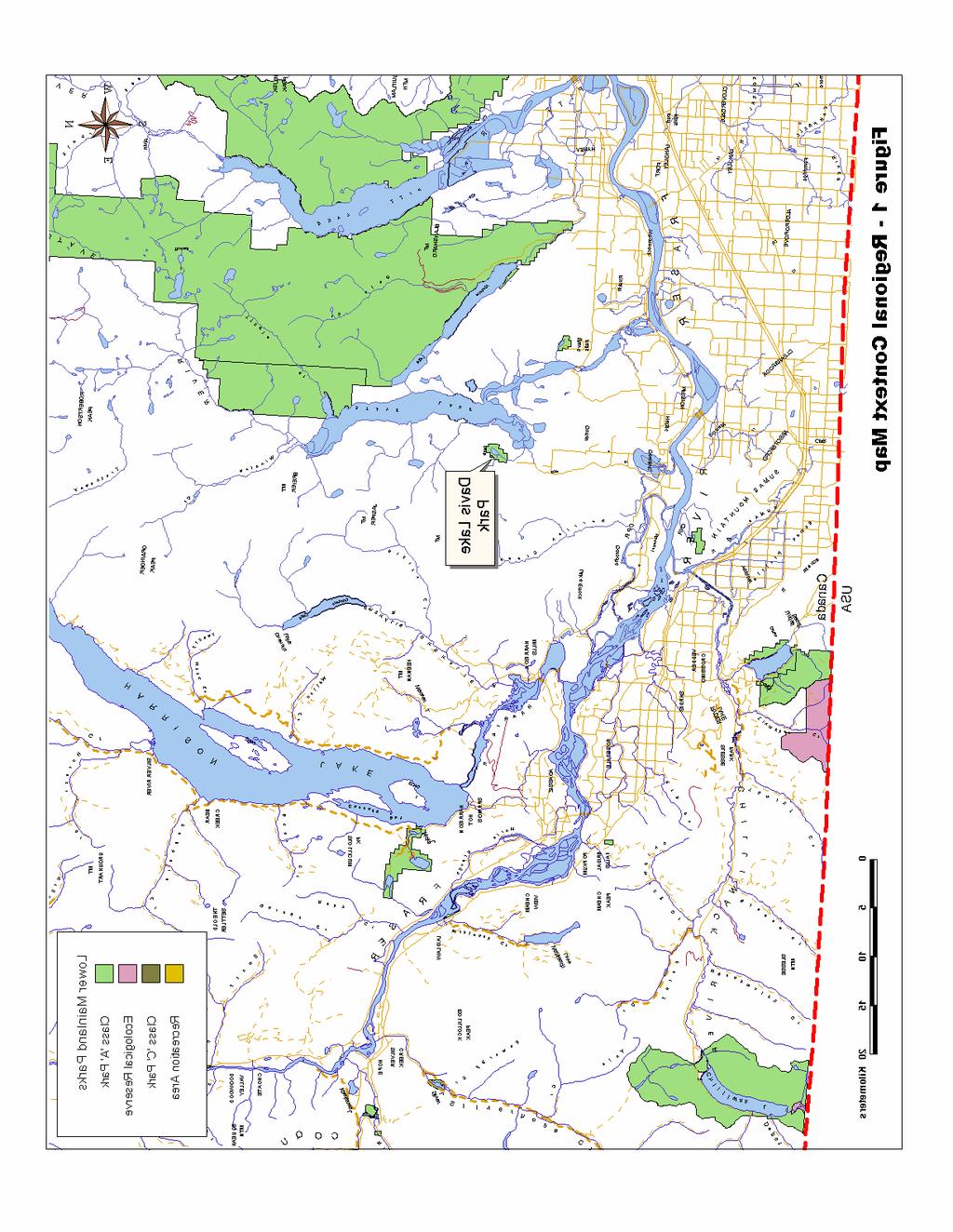
6 Introduction The Management Planning Process A Management Plan is an administrative manual and public document that directs protected area management for a five to ten year term. It sets out objectives and appropriate actions for conservation, recreation development, if appropriate, feature interpretation and protected area operations. Plan contents are based on an interpretation of current information relating to natural and cultural resources, recreation use, demand and activities both within the protected area and surrounding lands. The management planning process involves a rigorous analysis of the overall goals of the park, patterns of use, management objectives, identified conflicts, and public expectation. The plan, once approved, is to be employed in the design and development phase of the evolution of the park. Planning for the management of the park s resources and operation of the park will also be based on guidelines presented here. Background Summary Davis Lake is a 192-hectare park situated in the Lower Mainland area of British Columbia, approximately 19 kilometres north of Mission and 80 kilometres east of Vancouver (Figure 1). The park is readily accessible by residents of the Mission area and those of the Abbotsford and Matsqui communities via the Mission-Matsqui Bridge crossing the Fraser River. Prior to becoming a Class A provincial park in October, 1963, the land was unsuccessfully homesteaded in the s. During the 1940 s, Whonnock Lumber Company logged the area surrounding Davis Lake. Located in the Coastal Western Hemlock biogeoclimatic zone, the primary attraction of the park is the small warm-water lake and its beaches. This, combined with the natural setting that includes a scenic waterfall and representative western hemlock forest, offers an excellent site for developing park facilities to meet a small portion of the demand for recreation opportunities and outdoor education in the Lower Mainland. At present, there is very little opportunity for this type of recreation in the Mission- Matsqui area. The Fraser Valley Regional District recently rebuilt Cascade Falls Regional Park just south of Davis Lake Park. The District of Mission is responsible for many small parks and sports fields, however these parks do not offer an outdoor experience in a natural environment like Davis Lake Provincial Park. For similar outdoor experiences, Rolley Lake Provincial Park is available to the west of Davis Lake, and Sasquatch and Kilby Provincial Parks to the east. BC Hydro offers a similar recreational opportunity on the east arm of Stave Lake. 1
7 2
8 Relationship to Other Land Use Planning This management plan for Davis Lake Provincial Park builds on the approved 1980 Master Plan for the park and recreation/conservation strategies outlined in the 1996 Lower Mainland Protected Area Strategy. The plan is influenced by management plans on surrounding public lands, in particular the recreation plans of BC Hydro, the Municipality of Mission and the Fraser Valley Regional District. For Davis Lake Park, the plan is intended to complement these other plans and to provide recreational opportunities in a natural environment for the inspiration, use and enjoyment of the public. These opportunities will focus on partially meeting the demand for camping, day-use areas and outdoor education and interpretation within the Mission area and within the Lower Mainland region. Management Issues The plan addresses a number of management issues raised by the public and identified by BC Parks. These issues include: Conservation Issues Managing rare and fragile ecosystems such as the pure hemlock stand located at the south-east end of Davis Lake. The area contains steep slopes and large alluvial fans at the base of Murdo Creek where potential erosion could be damaging to the ecosystem. Managing general wildlife habitat. Preserving the biological diversity of the area. Many different vegetation types, including a great number of moss and lichen species and some large specimens of cedar and hemlock, are trees found in the area. Recreation Issues Addressing unregulated use that has led to significant environmental impacts. Managing vehicle and trail access to facilitate the public use of the park for recreational and educational/interpretive uses. Meeting recreation demands for the Mission Matsqui area by providing a warmwater, small lake park experience with opportunities for individual and group camping, day-use, and outdoor education and interpretation activities. This development will relieve some pressure from surrounding recreation areas with similar resources. Contributing to recreation facility priorities at a regional level. Based on demographics and existing park developments in the Lower Mainland, there is a need for facilities to support group camping, warm-water day use access and interpretation. 3
9 The Role of the Park Provincial and Regional Context Davis Lake Provincial Park, together with the surrounding protected areas including Golden Ears, Rolley Lake, Cultus Lake, and Sasquatch Provincial Parks, provides a broad area for recreational opportunities in the lower Fraser Valley of British Columbia. The park contributes to the protection of significant natural, cultural and recreational features in the Lower Mainland. Davis Lake is a small, warm water lake typical of the Fraser Valley area and comparable to other nearby protected lakes such as Rolley Lake and Alice Lake. Davis Lake Provincial Park provides water-based recreational opportunities including overnight camping with some day-use, fishing, boating, hiking, and outdoor education activities in a secluded setting close to a largely populated area. This park, although it provides similar opportunities as nearby provincial parks, also represents unique ecology not commonly found in the area. A pure stand of western hemlock, large cedar stumps with interpretive value, diverse vegetation and land forms, and prime bird habitat all provide for a unique recreational and interpretive experience. Conservation Role In keeping with the defined conservation goals of BC Parks protected area system, the conservation goals for Davis Lake Provincial Park are: To conserve special biological features such as a pure western hemlock stand and prime bird habitat. To conserve representative and diverse elements of the Coastal Western Hemlock biogeoclimatic zone. To preserve a natural setting for educational and recreational use by the public. Tourism and Outdoor Recreation Role Davis Lake has the potential to provide a broad spectrum of opportunities for recreation in the Lower Mainland. The outdoor recreation and tourism roles that this park serves are: To provide water-based recreational activities in a small-lake setting close to a populated area which will help satisfy regional outdoor recreation demands for group and individual camping and day-use. 4

10 Outdoor Education/Interpretation Role To provide an opportunity for outdoor education and interpretation activities. Cultural Heritage Role To protect potential cultural heritage features associated with First Nation and European use of the park. Figure 2: Davis Lake 5
11 Vision Statement Davis Lake Provincial Park is centered on a small lake where fishing and camping opportunities will be developed in an effort to contribute to the need for outdoor, waterbased recreation in the region. Deer Lake and Hicks Lake in Sasquatch Provincial Park and Rolley Lake and Alice Lake provide similar opportunities in this area of the Province, however, Davis Lake is a site where mainly visitors from Mission, Matsqui, Agassiz and Abbotsford will retreat for inspiration, use and enjoyment in a natural setting. Because the public has enjoyed a very secluded, rustic experience on this lake, development of the park will enhance this type of experience. Use will be limited and the main users will be tent and vehicle campers, small-lake anglers, and outdoor education enthusiasts. The facilities to be developed will adhere to the qualities of a rustic experience. A group campground will be developed as a basis for outdoor education and interpretive programs. Campsites focusing on the beach area and limited day access and parking will be provided. Relationship with First Nations BC Parks had limited information on the use of the park by First Nations. An archeological assessment of the immediate lake environment found no record of archeological sites. However, further archeological assessment is required. 6
12 Park Zoning Zoning is a planning procedure used to organize a provincial park into comprehensive land and water units based on management objectives. Davis Lake Provincial Park will be zoned for Intensive Recreation, Natural Environment, and Special Features (Figure 2). The small area zoned as Intensive Recreation will be used for public vehicles to access the park and developments. The Special Features Zone will cover especially sensitive and unique areas. The Natural Environment Zone will cover the remaining area of the park and will encompass only trail development. Intensive Recreation Zone The objectives for the Intensive Recreation Zone are to provide for a variety of facilityoriented recreational opportunities. Approximately 60 hectares will be zoned for Intensive Recreation at the north end of the lake where a 20 unit vehicle campground and a 20 unit walk-in campground will be developed. A limited day use area, providing access to the lake for the loading and unloading of car-top boats and for swimming and picnicking, will also be developed. The south end of the lake will be developed as a group campground and interpretive area that will be associated with Golden Ears outdoor education program. The road that provides access to the park and the park developments will also be included in this zone. Natural Environment Zone The objectives for the Natural Environment Zone are to provide for intermediate levels of outdoor recreational opportunities/uses in a natural setting. Most of the park area (130 ha) will be included in this zone where no motorized activities will be allowed. Development of the Davis Lake Trail around Davis Lake will provide hiking opportunities from the north end of the campground, around the west side of the lake, through the pure hemlock stand and over the alluvial fan at the base of Murdo Creek. The McDonald Trail will branch off the Davis LakeTrail to provide access to McDonald Falls. These trails will both be accessed by development of the north end of the park. Davis Lake itself will be included in this zone, accommodating non-motorized canoes, kayaks, and rowboats as well as swimmers and waders. 7
13 a v i s C r e e k W N S M u r d o E D Davis Lake 163 D a v i s C r e e k L a k e M u r d o M c D o n a l d F a l l s Zoning Intensive Recreation Lake (Natural Environment) k Natural Environment Special Features Figure 3 - Zoning Meters e e UTM grid (zone 10) r

14 Special Features Zone The Special Features Zone calls for preservation and presentation of the natural and cultural features. This type of zoning permits restricted recreation and interpretive use with minimal impact. The broad alluvial fan at the south end of the lake at the base of Murdo Creek creates highly sensitive bird habitat. The pure western hemlock stand of trees and the outlet of Davis Lake will be included in the Special Features Zone. In this zone, the Davis Lake Trail will be an interpretive trail, providing the only access and restricting any intensive recreation activities. Figure 4: Western Hemlock Forest 9
15 Managing Natural, Cultural & Recreational Values General Management Policies Park management will be directed towards conserving the natural and cultural values found within the park, while providing a variety of compatible outdoor recreation activities. As such, the principles of conservation management in Davis Lake Park will emphasize managing human impacts to prevent or minimize degradation of natural ecological process and cultural features. This section outlines management objectives and actions which provide general direction regarding park management and identifies priorities for specific management actions. These objectives and actions reflect the Park Act and the Park Act Regulations. Land and Resource Tenures Presently, there are two park use permits in effect in the Davis Lake area (Figure 5). The Ministry of Forests holds a permit to use the main road, which runs through the provincial park to the north-east of Davis Lake, for access to the Douglas Provincial Forest. This permit expires in June The second permit expires in September 2009 and is held by the Golden Ears Outdoor Learning Society for field camp purposes. This permit allows the construction of a structure, which would be the basis of an outdoor learning centre, and occupation of 5 kilometers square radius (sic) of parkland at the south end of Davis Lake. The structure would be provincially owned and would coincide with the proposed group campground at the south end of the lake. This structure is still in the planning stages. Management Objective: To manage existing permits. Management Strategy Clarify and revise if necessary, the terms of the permit issued to the Golden Ears Outdoor Learning Centre with respect to area (5 square kilometer radius), type of overnight accommodation, food services and special events envisioned and regulation and prohibition of movement of the public within the permit area. 10
16 k e Meters N W E a v i s C r e e k S D Davis Lake 163 D a v i s C r e e k L a k e M u r d o M c D o n a l d F a l l s Park Use Permits MOF Access Outdoor Learning Center e Figure 5 - Park Use Permits UTM grid (zone 10)
17 Water Nestled in the narrow steep-sided valley that runs generally north-south, Davis Lake is the park's principal recreation feature. The lake is approximately 1,000 metres long, 450 metres wide, has a maximum depth of 30 metres and covers an area of 26 hectares. Its elevation is slightly over 180 metres above sea level. The total length of shoreline is about 2500 metres consisting primarily of steep, heavily vegetated, rocky slopes with the exception of two small sand and fine gravel beaches totaling about 500 metres in length. The two small beaches are situated at both the north and south ends of the lake and are currently used by both campers and day users. The water is warm during the summer months and the lake level does not fluctuate more than 1 to 1.5 metres over the year. The foreshore fronting the beach at the south end of the lake has a very steep drop off making it hazardous for family bathing. The steep valley walls contain many stream channels that cascade over the granodiorite bedrock and form alluvial fans on the valley bottom. Murdo Creek is the main stream feeding Davis Lake at the south end. The creek contains McDonald Falls, a 12 meter vertical descent onto the valley floor. Several flood channels have been carved through an alluvial fan and through the process of erosion and deposition, the beach at the south end of the lake was formed. This alluvial fan has given rise to a unique and rather sensitive ecosystem that should be protected for educational and interpretive value. Generally, the steep valley walls and logging activity on the adjacent lands have contributed significantly to unpredictable drainage patterns within the park area. Some 10 years ago, the main creek at the south end of the lake was cleared of logs and debris. This clearing allowed the stream flush to increase, clearing out any excess substrates, exposing the gravel and creating a more hospitable place for fish spawning. This was done to enhance the coastal cutthroat trout population. Management Objective: To protect the water quality of the lake and its tributaries. Management Strategies: Design and locate all facilities to minimize risk of contaminating water sources protect delicate alluvial fans, the small beaches, and the surrounding ecosystems. Prohibit motorized boats on the lake. 12
18 Vegetation Located within the Coastal Western Hemlock Biogeoclimatic Zone, the park has been previously logged. The existing vegetation is Western hemlock, Douglas-fir, and Western red cedar interspersed with Douglas maple, alder, vine maple, salmonberry and blue huckleberry. The most significant vegetative feature is the virtually pure stand of western hemlock at the sound end of the lake. Much of this stand consists of large trees ranging from 50 to 75 cm d.b.h. and 30 to 50 metres tall with a very open floor carpeted with sword fern and deer fern. There are also several large red cedar stumps (2 to 3 metres d.b.h.) in this area. These have interpretation value because of the visible springboard notches and there are western hemlock growing atop them. There is a large number of small plant and moss species, which creates exceptional diversity, throughout the park. Management Objective: To conserve park vegetation, protect unique ecosystems such as the pure hemlock stand and use the diversity of the area as an interpretive tool. Management Strategies: Prevent any type of recreational use that compromises the ecological integrity, as the area holds a great diversity in the number of vegetation species that are at risk due to unstable soils and hydrological processes. Assess the hazard trees on the alluvial fan south of the lake while recognizing these trees are prime wildlife habitat. Monitor bank erosions and consider the protection of the bank in cases where outstanding tree specimens are threatened. Terrestrial Wildlife Because of the high level of floral diversity in such a small area, wildlife potential terrestrially speaking, is great. Forested areas next to an open lake always provide potential bird habitat and often spotted owl habitat. This area is no exception. The pure hemlock stand, large diameter trees, nearby water and alluvial fans all provide prime habitat for bears, ungulates, avian species, small mammals, reptiles and amphibians. The alluvial fan at the south end of the lake had flooded previously, killing the trees. Woodpeckers and sapsuckers as well as other avian species have since used these trees for feeding and nesting. Management Objective: To protect wildlife values while providing an interpretive and educational outdoor recreation experience for users. 13
19 Management Strategies: Conduct a wildlife habitat inventory for the area. Develop a wildlife viewing strategy to enhance visitor experience and appreciation for environmental sensitivity. Aquatic Wildlife In the aquatic environment, wildlife habitat is also excellent. Presently the lake supports small cutthroat trout (10 to 23 cm in length) as well as squawfish minnow. Some inlets to the lake were previously plugged with logging debris and have since been cleared. Fry have been observed in one stream. Davis Creek, the outlet draining the lake, drops about 120 metres into Stave Lake. The vertical rise from Stave Lake to Davis Lake on the creek may have considerable bearing on the fishery potential of Davis Lake. However, the lake is stocked with 1200 cutthroat trout annually and would need to be in the future to maintain an adequate sport fishery. Management Objective: To conserve fish habitat and maintain fish stocks that will permit a sustainable recreational fishery in Davis Lake. Management Strategies: Develop a fishery management strategy that builds on current knowledge and addresses lake stocking requirements and habitat protection priority. Design and locate all park facilities to minimize risk of disturbance to fish habitat at streams and along lakeshores. Review stocking and management requirements for lakes within the park. Cultural Heritage No cultural history appears to be documented prior to In the early part of the 20 th century, several attempts were made at homesteading the area but none were successful. During that time, selective timber cutting took place in the park area. During the 1940 s the Whonnock Lumber Company logged the area to the north of Davis Lake and presently active logging is being carried out to the north and east of the park. There are no recorded archaeological sites within the park. However, there is a monument to Murdock McDonald (one of the homesteaders who apparently drowned in the lake) situated near Murdo Creek at the south end of the lake. 14
20 Management Objective: To determine the extent of cultural features in the park and if found, protect them. Management Strategy: Prepare a Cultural History Theme document. Visual Landscape Davis Lake Park, including the lake itself, is an enclosed landscape due to the abundance and age of the vegetation. Any areas that are susceptible to forest harvesting are in the distance where they do not stand out when viewed from Davis Lake. Management Objective: To maintain and enhance the visual quality of Davis Lake Provincial Park, park access roads, and the surrounding area for the enjoyment of the park visitors. Management Strategy: Liaise with the Ministry of Forests regarding harvesting plans and visual quality objectives for the surrounding area where these areas may be viewed from the park. 15
21 Managing Opportunities for Outdoor Recreation Davis Lake Provincial Park provides opportunities to help meet the local and regional demand for outdoor recreation including day use, camping, hiking, angling, and boating, as well as group camping and outdoor education and interpretation. These opportunities will be limited by geography and developed at an appropriate level in accordance to the environmental sensitivity of the area. Precaution will be taken in facility development to avoid major soil disturbances in sensitive areas. Division policy concerning environment assessment, hazard trees and public safety will be applied in this area. Access Park users access Davis Lake via Sylvester Forest Access Road travelling north from Mission. Just north of the park boundary, a secondary road descends south back down the slope to Davis Lake. This road s grade and alignment necessitate its relocation to the west. The Weatherhead Creek area to the north west of the park provides exceptional recreation opportunities and access to Stave Lake. Management Objectives: To maintain motor vehicle access to the park developments at the north end of the lake. To restrict motor-vehicle access to the south end of the lake for group site users and outdoor learning facility users. To provide a scenic entrance to the park. Management Strategies: Encourage the Ministry of Forests to maintain roadside vegetation along the Forest Service access road south of the park Provide vehicle access roads and parking lots to future park developments at the north end of Davis Lake Add, to the park, a portion of the Douglas Provincial Forest that contains the proposed relocated access road to the north end of Davis Lake. Study Weatherhead Creek area as a possible addition to the park (Figure 6). 16
22 t e r W N E S C r e e k h e r h e a d Park Bounda ry Legend Proposed Study Area W e a 2 77 a v i s C r e e k M u r d D Lake Davis 163 D a v i s L a k e M u r d o C r e e k M c D o n a l d F a l l s S T A V E L A K E k L A K E Kilometers e Figure 6 - Proposed Park Study Area UTM grid (zone 10) C
23 Day Use Because of the small area of beach at the north and south ends of the lake, and the relative instability of the land due to hydrological attributes, the amount of development for day use will be limited. A staging area will be developed for anglers, day-hikers and sunbathers. Management Objective: To provide for limited day use. Management Strategies: Develop a ten-car parking area at the north end of the lake for day hikers and provide beach access for anglers and waders. Develop a boat launch area where car-top boats can be loaded and unloaded. Frontcountry Camping The park presents the opportunity to provide limited front country camping to help meet local and regional demand. Management Objectives: To provide a vehicle access and a walk-in camping experience at the north end of Davis Lake. To provide an area for group camping that is affiliated with outdoor learning and interpretation in Golden Ears Provincial Park. Management Strategies: Develop a 20 site walk-in campground and a 20 site vehicle access campground. Develop a group campground at the south of Davis Lake. Hiking Because of the diverse ecosystem in the park, hiking trails will be built for the public to experience these natural features. These trails will be included in the Natural Environment Zone and will access natural features in the Special Features Zone. Management Objective: To provide hiking opportunities around the west side of the lake and through the Special Features Zone on the Davis Lake Trail, as well as access to McDonald Falls by way of McDonald Trail. 18
24 Management Strategies: Construct and maintain the Davis Lake Trail as a Type II trail to offer trail access to the south end of the lake, and through the Special Features Zone. Construct and maintain McDonald Trail to access McDonald Falls from the lake. Deactivate and rehabilitate the upper section of McDonald Trail from the main access road. Figure 7 shows the overall development concept for Davis Lake. Fishing and Hunting Presently, there is a limited fishery in Davis Lake due to the small populations of cutthroat trout. However, it is stocked annually with some 1200 fish and will be enhanced for the purpose of maintaining a sport fishery for local users. Management Objective: To maintain a recreational fishing experience at Davis Lake. Management Strategy: As the lake s fishery is not presently self-sustaining, an enhancement program involving both habitat improvement and stocking projects is required. The Park is closed to hunting because of its size and recreation use. Boating The size of Davis Lake and the rustic nature of the area calls for non-motorized boats only to access the lake for boating and fishing. Management Objective: To provide a safe and appropriate opportunity for boating on a small lake. Management Strategies: Prohibit outboard motor use on the lake. Provide launching opportunities for canoes, kayaks, sailboards and rowboats. 19
25 e Meters Relocated Park Access W N S E a v i s Service Road C r e e k Group Campground M u r d o D Lake Davis»~»! 163»> D a v i s McDonald Falls Trail C r e e k Davis Lake Trail L a k e»% M u r d o F M c D o n a a l l s l d Proposed Facilities»!»%»~ Vehicle Campground Group Camping Walk-In Campground e k Figure 7 - Park Conceptual Plan UTM grid (zone 10) r
26 Horseback Riding The small size of the park and the lack of demand for horseback riding around Davis Lake indicates that the development of riding trails is unnecessary. Mountain and Motorized Biking The small size and rustic nature of the park is not conducive to mountain or authorized biking throughout the park. However, opportunities exist adjacent to the park in the Provincial Forest. Commercial Recreation Opportunities Because of the small size of the park, and existing commercial opportunities at the turnoff to the park on the Lougheed Highway, no commercial services will be offered at Davis Lake. Communications Communicating information about the park is an important aspect of this plan. Increased awareness provides major support for management strategies and decisions. BC Parks will liaise with the tourism sector in Mission in order to communicate park information to the public. Information and Awareness BC Parks provides information in brochures and a variety of publications. As well, the park is highlighted in a number of guidebooks. The development of Davis Lake Provincial Park will be promoted so the public is aware of the new facilities. Management Objective: To ensure that the public is aware of the park facilities and recreation opportunity. Management Strategies: Provide local tourism and information centres with updated information on the park s natural warm-water lake and recreation opportunities. Coordinate information with the Lower Mainland Region s park system as a whole. 21
27 In-Park Information Information will be provided to park visitors for the purpose of informing them about the type of recreation that is available at Davis Lake. Management Objective: To provide the park visitors with adequate information on park facilities, availability, safety information, and interpretive and outdoor educational opportunities found in Davis Lake Provincial Park. Management Strategy: Install information shelters to provide information on the park features, facilities, and safety regulations Natural and Cultural Heritage Education The ecological diversity found at Davis Lake Provincial Park provides opportunities for the public to learn more about their surroundings. The Golden Ears Outdoor Learning Program will aid in providing this type of awareness to the park users. Education helps the public to understand the need for respect for the environment. Management Objectives: To provide educational opportunities that describe the unique interpretive values within the park. To use the Golden Ears Outdoor Learning Program to facilitate outdoor learning and ecological awareness. Management Strategy: Develop the south end group campground as a site for an outdoor education program in association with Golden Ears Outdoor Education Program 22
28 Implementation The following is the priority for implementing strategies in the park. High Priority Strategies Prepare a cultural history theme document. Prohibit motorized boats on the lake. Implement conceptual plan for camping and day use. Add relocated access road to the park once development is complete. Construct and maintain Davis Lake Trail as a Type II trail to the south end of the lake, and through the Special Features Zone. Construct and maintain McDonald Trail to access McDonald Falls from the lake. Provide information on the park features, facilities, and safety regulations. Encourage Ministry of Forest to maintain aesthetics along Forest Services Road south of the park. Task or Project Strategies Clarify, and revise if necessary, the terms of Golden Ears Outdoor Learning Centre permit plan. Assess the hazard trees on the alluvial fan south of the lake while recognizing these trees are prime wildlife habitat. Conduct wildlife habitat inventory for the area Develop a wildlife viewing strategy to enhance visitor experience and appreciation for environmental sensitivity. Develop a fishery management strategy that builds on current knowledge and addresses lake stocking requirements and habitat protection priority Review stocking and management requirements for lakes within the park Liaise with the Ministry of Forests regarding harvesting plans and visual quality objectives for the surrounding area. Deactivate and rehabilitate the upper section of McDonald Trail from the main access road. Provide local tourism and information centres with updated information with emphasis placed on the park s natural warm-water lake and recreation opportunities. Study Weatherhead Creek as a possible park addition. Ongoing or Monitoring Strategies Monitor bank erosions and consider the protection of the bank in cases where outstanding tree specimens are threatened. Design and locate all facilities to minimize risk of contaminated water sources and of disturbance to habitat. 23
ANAGEMENT P LAN. July for Chilliwack Lake Park & Chilliwack River Ecological Reserve. Ministry of Environment, Lands and Parks BC Parks Division
 M ANAGEMENT P LAN July 2000 for Chilliwack Lake Park & Chilliwack River Ecological Reserve Ministry of Environment, Lands and Parks BC Parks Division Chilliwack Lake Provincial Park & Chilliwack River
MARBLE RIVER PROVINCIAL PARK
 MARBLE RIVER PROVINCIAL PARK PURPOSE STATEMENT AND ZONING PLAN March 2003 MARBLE RIVER PROVINCIAL PARK Purpose Statement and Zoning Plan Primary Role The primary role of Marble River Park is to protect
MAIN LAKE PROVINCIAL PARK
 MAIN LAKE PROVINCIAL PARK PURPOSE STATEMENT AND ZONING PLAN March 2003 MAIN LAKE PROVINCIAL PARK Purpose Statement and Zoning Plan Primary Role The primary role of Main Lake Park is to protect a biologically
MANAGEMENT DIRECTION STATEMENT
 Lower Mainland District MAAGEMET DIRECTIO STATEMET January 2001 for Liumchen Ecological Reserve Ministry of Environment Lands and Parks BC Parks Division Table of Contents Page Introduction... 1 Purpose
MANAGEMENT DIRECTION STATEMENT June, 1999
 Thompson River District MANAGEMENT DIRECTION STATEMENT June, 1999 for Roche Lake Provincial Park Ministry of Environment Lands and Parks BC Parks Division Table of Contents I. Introduction A. Setting
ANAGEMENT. LAN November, 1996
 M ANAGEMENT P LAN November, 1996 for Paul Lake Provincial Park Ministry of Environment, Lands and Parks BC Parks Department Paul Lake Provincial Park M ANAGEMENT P LAN Prepared by BC Parks Kamloops Area
BLANKET CREEK PROVINCIAL PARK
 BLANKET CREEK PROVINCIAL PARK PURPOSE STATEMENT AND ZONING PLAN February 2003 BLANKET CREEK PROVINCIAL PARK Purpose Statement and Zoning Plan Primary Role The primary role of Blanket Creek Park is to maintain
MANAGEMENT DIRECTION STATEMENT June, 1999
 Thompson River District MANAGEMENT DIRECTION STATEMENT June, 1999 for Clearwater River Corridor (Addition to Wells Gray Park) Ministry of Environment Lands and Parks BC Parks Division ii Table of Contents
ROBERTS CREEK PROVINCIAL PARK MASTER PLAN. November, 1981
 Ministry of Lands, Parks and Housing Parks and Outdoor Recreation Division Park Operations Branch North Vancouver, B. C. ROBERTS CREEK PROVINCIAL PARK MASTER PLAN November, 1981 Mr. G. Trachuk Director
ANAGEMENT P LAN. February, for Elk Lakes and Height of the Rockies Provincial Parks. Ministry of Environment, Lands and Parks BC Parks Division
 M ANAGEMENT P LAN February, 1999 for Elk Lakes and Height of the Rockies Provincial Parks Ministry of Environment, Lands and Parks BC Parks Division Elk Lakes & Height of the Rockies Provincial Parks M
Outdoor Recreation Opportunities Management
 Outdoor Recreation Opportunities Management Introduction The natural features of Height of the Rockies and Elk Lakes provincial parks provide a wide variety of outdoor recreational activities. However,
Yard Creek Provincial Park. Management Plan
 Yard Creek Provincial Park Management Plan Draft January 2010 Yard Creek Provincial Park Management Plan Approved by: telàlsemkin/siyam/chief Scott Benton Bill Williams Squamish Executive Director ation
VARGAS ISLAND PROVINCIAL PARK
 VARGAS ISLAND PROVINCIAL PARK PURPOSE STATEMENT AND ZONING PLAN February 2003 VARGAS ISLAND PROVINCIAL PARK Purpose Statement and Zoning Plan Primary Role The primary role of Vargas Island Park is to protect
SHUSWAP LAKE MARINE PROVINCIAL PARK
 SHUSWAP LAKE MARINE PROVINCIAL PARK Purpose Statement and Zoning Plan The primary role of the Shuswap Lake Marine Provincial Park is to provide a system of sites for marine overnight and day use of Shuswap
Appendix A BC Provincial Parks System Goals
 Appendix A BC Provincial Parks System Goals The British Columbia Provincial Parks System has two mandates: To conserve significant and representative natural and cultural resources To provide a wide variety
SPECTACLE LAKE PROVINCIAL PARK PURPOSE STATEMENT AND ZONING PLAN
 SPECTACLE LAKE PROVINCIAL PARK PURPOSE STATEMENT AND ZONING PLAN August 2003 1 SPECTACLE LAKE PROVINCIAL PARK Purpose Statement and Zoning Plan Primary Role The primary role of Spectacle Lake Park is to
SANTA-BOCA PROVINCIAL PARK
 SANTA-BOCA PROVINCIAL PARK PURPOSE STATEMENT AND ZONING PLAN March 2003 SANTA-BOCA PROVINCIAL PARK Purpose Statement and Zoning Plan Primary Role The primary role of Santa-Boca Park is to provide marine-based
5.0 OUTDOOR RECREATION OPPORTUNITIES AND MANAGEMENT
 5.0 OUTDOOR RECREATION OPPORTUNITIES AND MANAGEMENT 5.1 Introduction This section describes the range of recreational activities that currently take place in Marble Range and Edge Hills Parks, as well
Marchand Provincial Park. Management Plan
 Marchand Provincial Park Management Plan 2 Marchand Provincial Park Table of Contents 1. Introduction... 3 2. Park History... 3 3. Park Attributes... 4 3.1 Natural... 4 3.2 Recreational... 4 3.3 Additional
Role of the Protected Area
 Role of the Protected Area Provincial and Regional Context Height of the Rockies and Elk Lakes provincial parks lie in southeastern British Columbia in the Rocky Mountains, about 85 km southwest of Calgary,
2.0 PARK VISION AND ROLES
 2.0 PARK VISION AND ROLES 2.1 Significance in the Protected Area System Marble Range and Edge Hills provincial parks protect 6.8% of the Pavillion Ranges Ecosection, which is located in the Southern Interior
MANAGEMENT DIRECTION STATEMENT March 2003
 Skeena Region MAAGEMET DIRECTIO STATEMET March 2003 for Meziadin Lake Provincial Park Ministry of Water, Land and Air Protection Environmental Stewardsh Division This page left blank on purpose ii Table
FINGER-TATUK PROVINCIAL PARK
 FINGER-TATUK PROVINCIAL PARK PURPOSE STATEMENT AND ZONING PLAN March 2003 FINGER-TATUK PROVINCIAL PARK Purpose Statement and Zoning Plan Finger-Tatuk Provincial Park is 17,151 ha in size. It includes the
Pillar Park. Management Plan
 Pillar Park Management Plan January 2014 Pillar Park Management Plan Approved by: Jeff Leahy Regional Director Thompson Cariboo Region BC Parks January 9, 2014 Date Brian Bawtinheimer Executive Director
KANANASKIS COUNTRY PROVINCIAL RECREATION AREAS MANAGEMENT PLAN DRAFT TERMS OF REFERENCE - November 20, 2007
 KANANASKIS COUNTRY PROVINCIAL RECREATION AREAS MANAGEMENT PLAN DRAFT TERMS OF REFERENCE - November 20, 2007 BACKGROUND There are 42 Provincial Recreation Areas (PRAs) within Kananaskis Country located
Outdoor Recreation Opportunities Management
 Outdoor Recreation Opportunities Management Introduction A major role of a management plan is to provide direction regarding the types of recreation that are appropriate, and to outline the steps that
Sasagiu Rapids Provincial Park. Draft Management Plan
 Sasagiu Rapids Provincial Park Draft Management Plan 2 Sasagiu Rapids Provincial Park Table of Contents 1. Introduction... 3 2. Background and Park Attributes... 3 2.1 Park History.... 3 2.2 Natural Features...
As outlined in the Tatshenshini-Alsek Park Management Agreement, park management will:
 Management Strategy General Strategy The priority management focus for the park is to ensure that its internationally significant natural, cultural heritage and recreational values are protected and that
Watchorn Provincial Park. Management Plan
 Watchorn Provincial Park Management Plan 2 Watchorn Provincial Park Table of Contents 1. Introduction... 3 2. Park History... 3 3. Park Attributes... 3 3.1 Natural... 4 3.2 Recreational... 4 3.3 Additional
ADDENDA. 1. It does not conform to the Master Plan format in the following areas: Statement of Purpose - clarification of parks purpose in system.
 File: 2-7-2-79-27 ADDENDA Plan for Saltery Bay Park This plan has been reviewed and is approved with the following comments and conditions: 1. It does not conform to the Master Plan format in the following
Natural and Cultural Values and Their Management...18
 Skagit Valley Provincial Park Management Plan Table of Contents Plan Highlights...4 Introduction...5 The Management Planning Process...5 Background Summary...6 Relationship to Other Land Use Planning...8
CARMANAH WALBRAN PROVINCIAL PARK
 CARMANAH WALBRAN PROVINCIAL PARK PURPOSE STATEMENT AND ZONING PLAN September 2003 1 CARMANAH WALBRAN PROVINCIAL PARK Purpose Statement and Zoning Plan Carmanah Walbran Provincial Park is an expansion of
SUGARBOWL-GRIZZLY DEN PROVINCIAL PARK AND SUGARBOWL-GRIZZLY DEN PROTECTED AREA Purpose Statement and Zoning Plan
 SUGARBOWL-GRIZZLY DEN PROVINCIAL PARK AND SUGARBOWL-GRIZZLY DEN PROTECTED AREA Purpose Statement and Zoning Plan Located one hour east of Prince George on Highway 16, Sugarbowl-Grizzly Den Provincial Park
KOOTENAY LAKE PROVINCIAL PARK (MIDGE CREEK SITE)
") KOOTENAY LAKE PROVINCIAL PARK (MIDGE CREEK SITE) PURPOSE STATEMENT AND ZONING PLAN February 2003 Approved by: KOOTENAY LAKE PROVINCIAL PARK (Midge Creek Site) Purpose Statement and Zoning Plan Primary
KOOTENAY LAKE PROVINCIAL PARK (MIDGE CREEK SITE) PURPOSE STATEMENT AND ZONING PLAN February 2003 Approved by: KOOTENAY LAKE PROVINCIAL PARK (Midge Creek Site) Purpose Statement and Zoning Plan Primary
Whitemouth Falls Provincial Park. Draft Management Plan
 Whitemouth Falls Provincial Park Draft Management Plan Whitemouth Falls Provincial Park Draft Management Plan Table of Contents 1. Introduction... 3 2. Park History... 3 3. Park Attributes... 4 3.1 Natural...
Beaver Creek Provincial Park. Management Plan
 Beaver Creek Provincial Park Management Plan 2 Beaver Creek Provincial Park Table of Contents 1. Introduction... 3 2. Park History... 3 3. Park Attributes... 4 3.1 Natural... 4 3.2 Recreational... 4 4.
MANAGEMENT DIRECTION STATEMENT June, 1999
 Garibaldi/Sunshine Coast District MAAGEMET DIRECTIO STATEMET June, 1999 for Homathko Estuary Provincial Park Ministry of Environment Lands and Parks BC Parks Division TABLE OF COTETS Introduction...1
Clearwater Lake Provincial Park. Draft Management Plan
 Clearwater Lake Provincial Park Draft Management Plan Clearwater Lake Provincial Park Draft Management Plan Table of Contents 1. Introduction... 3 2. Park History... 4 3. Park Attributes... 4 3.1 Location/Access...4
Proposal to Redevelop Lower Kananaskis River-Barrier Lake. Bow Valley Provincial Park
 Frequently Asked Questions Proposal to Redevelop Lower Kananaskis River-Barrier Lake Bow Valley Provincial Park Frequently Asked Questions What has been decided? What are the details of the plan? What
THUNDER HILL PROVINCIAL PARK
 THUNDER HILL PROVINCIAL PARK PURPOSE STATEMENT AND ZONING PLAN February 2003 Approved by: THUNDER HILL PROVINCIAL PARK Purpose Statement and Zoning Plan Primary Role The primary role of Thunder Hill Provincial
Stuart River Provincial Park Purpose Statement and Zoning Plan
 Stuart River Provincial Park Purpose Statement and Zoning Plan Stuart River Provincial Park protects three-quarters of the 110 kilometer long Stuart River corridor between Stuart Lake and the Nechako River.
The following criteria were used to identify Benchmark Areas:
 7.0 BENCHMARK AREAS The Churn Creek Protected Area offers a significant opportunity to learn more about how grassland ecosystems function. One of the key tools that will be used to monitor larger grassland
APPENDIX. Alberta Land Stewardship Act AMENDMENTS TO THE SOUTH SASKATCHEWAN REGIONAL PLAN
 APPENDIX Alberta Land Stewardship Act AMENDMENTS TO THE SOUTH SASKATCHEWAN REGIONAL PLAN 1 All references to Alberta Environment and Sustainable Resource Development, Environment and Sustainable Resource
OMINEACA PROVINCIAL PARK
 OMINEACA PROVINCIAL PARK AND PROTECTED AREA PURPOSE STATEMENT AND ZONING PLAN March 2003 OMINECA PROVINCIAL PARK AND PROTECTED AREA Purpose Statement and Zoning Plan Omineca Park and Omineca Protected
NECHAKO CANYON PROTECTED AREA
 NECHAKO CANYON PROTECTED AREA PURPOSE STATEMENT AND ZONING PLAN March 2003 1 Nechako Canyon Protected Area Purpose Statement and Zoning Plan The Nechako Canyon Protected Area (1,246 hectares) is located
Steps in the Management Planning Process
 Steps in the Management Planning Process Developing a management plan for Kalamalka Lake Park will follow a multi-stage process. The planning process for this park is currently in the Draft Management
D IRECTION S TATEMENT
 Vancouver Island Region M ANAGEMENT D IRECTION S TATEMENT September 2003 for Lower Nimpkish Provincial Park Ministry of Water, Land and Air Protection Environmental Stewardship Lower Nimpkish Provincial
PLUMPER COVE MARINE PARK MASTER PLAN
 Lower Mainland Region Park Operations Branch Parks and Outdoor Recreation Division Ministry of Lands, Parks and Housing North Vancouver, B.C. PLUMPER COVE MARINE PARK MASTER PLAN DECEMBER, 1980 PLUMPER
Mackinnon Esker Ecological Reserve Draft - Management Plan
 Mackinnon Esker Ecological Reserve Draft - Management Plan May 2011 Photo Credit: This document replaces the direction provided in the Carp Lake Provincial Park and Protected Area and Mackinnon Esker Ecological
ANAGEMENT. LAN November, 1996
 M ANAGEMENT P LAN November, 1996 for Coldwater River Provincial Park Ministry of Environment, Lands and Parks BC Parks Department Coldwater River Provincial Park M ANAGEMENT P LAN Prepared by BC Parks
Richmond Centre for Disability
 Richmond Centre for Disability Duke of Edinburgh Challenge Gold Medal Level Expedition Information & Planning May 21 24, 2010 Overall Schedule Time Location Activity May 21, 2010, Friday 9 a.m. RCD To
Pembina Valley Provincial Park. Draft Management Plan
 Pembina Valley Provincial Park Draft Management Plan 2 Pembina Valley Provincial Park Table of Contents 1. Introduction... 3 2. Park History... 3 3. Park Attributes... 3 3.1 Natural... 3 3.2 Recreational...
Proposal to Redevelop Lower Kananaskis River-Barrier Lake. Bow Valley Provincial Park. Frequently Asked Questions
 Proposal to Redevelop Lower Kananaskis River-Barrier Lake Bow Valley Provincial Park Frequently Asked Questions What is being proposed? What are the details of the proposal? Where is the project area located?
MONTAGUE HARBOUR MARINE PROVINCIAL PARK
 MONTAGUE HARBOUR MARINE PROVINCIAL PARK PURPOSE STATEMENT AND ZONING PLAN March 2003 1 MONTAGUE HARBOUR MARINE PROVINCIAL PARK Purpose Statement and Zoning Plan Primary Role The primary role of Montague
MANAGEMENT DIRECTION STATEMENT March 2003
 Skeena Region MAAGEMET DIRECTIO STATEMET March 2003 for Great Glacier Provincial Park Ministry of Water, Land an Air Protection Environmental Stewardship Division ii This management direction statement
INLAND LAKE PROVINCIAL PARK
 INLAND LAKE PROVINCIAL PARK PURPOSE STATEMENT AND ZONING PLAN December 2002 INLAND LAKE PROVINCIAL PARK Purpose Statement and Zoning Plan Primary Role The primary role of Inland Lake Park is the protection
Evaluation of Outstanding Remarkable Values for Collawash River March 2011
 Evaluation of Outstanding Remarkable Values for Collawash River March 0 Segment From headwaters of East Fork Collawash River to Buckeye Creek Mileage: miles Free flowing: Yes Scenic:, Substantial River
STONE MOUNTAIN PROVINCIAL PARK Purpose Statement and Zoning Plan
 1 STONE MOUNTAIN PROVINCIAL PARK Purpose Statement and Zoning Plan Stone Mountain Provincial Park is situated 140 km west of Fort Nelson at Kilometre 595 of the Alaska Highway. The 25 690 ha park is located
Continental Divide National Scenic Trail Legislative History and Planning Guidance
 Continental Divide National Scenic Trail Legislative History and Planning Guidance Legislation, Policy, and Direction Regarding National Scenic Trails The National Trails System Act, P.L. 90-543, was passed
Finn Creek Park. Management Direction Statement Amendment
 Finn Creek Park Management Direction Statement Amendment November 2013 Management Direction Statement Amendment Approved by: Jeff Leahy Regional Director, Thompson Cariboo BC Parks November 12, 2013 Date
EPPER PASSAGE PROVINCIAL PARK PURPOSE STATEMENT AND ZONING PLAN
 EPPER PASSAGE PROVINCIAL PARK PURPOSE STATEMENT AND ZONING PLAN August 2003 1 EPPER PASSAGE PROVINCIAL PARK Purpose Statement and Zoning Plan Primary Role The primary role of Epper Passage Park is to protect
BROUGHTON ARCHIPELAGO PROVINCIAL PARK
 BROUGHTON ARCHIPELAGO PROVINCIAL PARK PURPOSE STATEMENT AND ZONING PLAN March 2003 BROUGHTON ARCHIPELAGO PROVINCIAL PARK Purpose Statement and Zoning Plan Primary Role The primary role is to contribute
Ouimet Canyon Provincial Nature Reserve. Management Plan
 Ouimet Canyon Provincial Nature Reserve Management Plan NOTE: This document has been scanned and formatted, and therefore is slightly different from the original version. -March 2002 Additional copies
PROUDLY BRINGING YOU CANADA AT ITS BEST. Management Planning Program NEWSLETTER #1 OCTOBER, 2000
 PROUDLY BRINGING YOU CANADA AT ITS BEST VUNTUT NATIONAL PARK Management Planning Program NEWSLETTER #1 OCTOBER, 2000 INTRODUCTION This newsletter launches the development of the first management plan for
SMITH RIVER FORT HALKETT PROTECTED AREA
 SMITH RIVER FORT HALKETT PROTECTED AREA PURPOSE STATEMENT AND ZONING PLAN Peace Region 2006 Approved by: Andy Ackerman, Regional Manager Environmental Stewardship Division Peace Region Date: 2006 Nancy
Criddle/Vane Homestead Provincial Park. Management Plan
 Criddle/Vane Homestead Provincial Park Management Plan 2 Criddle/Vane Homestead Provincial Park Table of Contents 1. Introduction... 3 2. Park History.... 3 3. Park Attributes.... 4 3.1 Natural.... 4 3.2
Birch Point Provincial Park. Management Plan
 Birch Point Provincial Park Management Plan 2 Birch Point Provincial Park Table of Contents 1. Introduction... 3 2. Park History... 3 3. Park Attributes... 4 3.1 Natural... 4 3.2 Recreational... 4 4. Park
ISBN c 1988 Government of Ontario Printed in Ontario, Canada
 Single copies of this publication are available for $2.00 from the Ontario Ministry of Natural Resources, Espanola District Office, P.O. Box 1340, 148 Fleming Street, Espanola, Ontario, POP 1CO, telephone:
Mackinnon Esker Ecological Reserve. Management Plan
 Mackinnon Esker Ecological Reserve Management Plan March 2017 Cover Page Photo Credit: Rob Bell This document replaces the direction provided in the Carp Lake Provincial Park and Protected Area and Mackinnon
Numaykoos Lake Provincial Park. Management Plan
 Numaykoos Lake Provincial Park Management Plan 2 Numaykoos Lake Provincial Park Table of Contents 1. Introduction... 3 2. Background... 3 3. Park Purpose... 5 4. Park Management Guidelines... 6 Appendix...
TRAILS WHERE TO FIND TRAILS IN NOVA SCOTIA
 TRAILs SIGNAGE Know the Signs............................ 44 WHERE YOU CAN RIDE Roads and Highways........................ 46 Designated Trails........................... 47 Established Trails...........................
MANAGEMENT DIRECTION STATEMENT
 Skeena District MAAGEMET DIRECTIO STATEMET July, 2000 for Driftwood Canyon Provincial Park Ministry of Environment Lands and Parks BC Parks Division i Table of Contents Driftwood Canyon Park Approvals
FINAL TESTIMONY 1 COMMITTEE ON RESOURCES UNITED STATES HOUSE OF REPRESENTATIVES. July 13, 2005 CONCERNING. Motorized Recreational Use of Federal Lands
 FINAL TESTIMONY 1 STATEMENT OF DALE BOSWORTH CHIEF Of the FOREST SERVICE UNITED STATES DEPARTMENT OF AGRICULTURE Before the SUBCOMMITTEE ON FORESTS AND FOREST HEALTH And the SUBCOMMITTEE ON NATIONAL PARKS,
Land Management Summary
 photo credit: ANGAIR Anglesea Heath Land Management Summary The Anglesea Heath (6,501 ha) was incorporated into the Great Otway National Park in January 2018. This provides an opportunity to consider the
TABLE OF CONTENTS. B. STATEMENT OF PURPOSE 8 1. Park Objectives 8 2. Manageme nt Philosophy 8
 TABLE OF CONTENTS Page A. INTRODUCTION 1 1. Setting 1 2. Regional Perspective 1 3. Present Development and Use 3 4. Land Status and Access 4 5. Demand 6 6. Purpose of Master Plan 7 B. STATEMENT OF PURPOSE
Pinawa Provincial Park. Draft Management Plan
 Pinawa Provincial Park Draft Management Plan Pinawa Provincial Park Draft Management Plan Table of Contents 1. Introduction... 3 2. Park History... 3 3. Park Attributes... 4 3.1 Natural... 4 3.2 Recreational...
Recreational Services Plan. Gatineau Park. Phase 1: Planning Framework
 Recreational Services Plan Gatineau Park Phase 1: Planning Framework 1 Plan Planning in Gatineau Park Gatineau Park : an overview Trends Preliminary assessment Strategic framework 2 Unique natural and
April 10, Mark Stiles San Juan Public Lands Center Manager 15 Burnett Court Durango, CO Dear Mark,
 Mark Stiles San Juan Public Lands Center Manager 15 Burnett Court Durango, CO 81301 Dear Mark, We are pleased to offer the following comments on the draft San Juan Public Lands Center management plans
Procedure for the Use of Power-Driven Mobility Devices on Mass Audubon Sanctuaries 1 September 17, 2012
 Procedure for the Use of Power-Driven Mobility Devices on Mass Audubon Sanctuaries 1 September 17, 2012 Background As part of Mass Audubon s mission to preserve the nature of Massachusetts for people and
PROPOSAL FOR RECLASSIFICATION, BOUNDARY AMENDMENT AND DRAFT CONCEPT PLAN FOR SASKATOON MOUNTAIN NATURAL AREA. Frequently Asked Questions
 PROPOSAL FOR RECLASSIFICATION, BOUNDARY AMENDMENT AND DRAFT CONCEPT PLAN FOR SASKATOON MOUNTAIN NATURAL AREA 1. Why is this proposal being put forward? Frequently Asked Questions For many years, Alberta
OCTOPUS ISLANDS PROVINCIAL PARK
 OCTOPUS ISLANDS PROVINCIAL PARK PURPOSE STATEMENT AND ZONING PLAN February 2003 OCTOPUS ISLANDS PROVINCIAL PARK Purpose Statement and Zoning Plan Primary Role The primary role of Octopus Islands Park is
Criddle/Vane Homestead Provincial Park. Draft Management Plan
 Criddle/Vane Homestead Provincial Park Draft Management Plan 2 Criddle/Vane Homestead Provincial Park Table of Contents 1. Introduction... 3 2. Park History.... 3 3. Park Attributes.... 3 3.1 Natural....
Little Limestone Lake Provincial Park. Draft Management Plan
 Little Limestone Lake Provincial Park Draft Management Plan Little Limestone Lake Provincial Park Draft Management Plan Table of Contents 1. Introduction... 3 2. Background... 3 3. Planning context...
ONE ISLAND LAKE PROVINCIAL PARK Purpose Statement and Zoning Plan
 ONE ISLAND LAKE PROVINCIAL PARK Purpose Statement and Zoning Plan Primary Role The primary role of One Island Lake Provincial Park is to provide recreational opportunities to regional and residential area
Bridge River Delta Park. Management Plan. Final Public Review Draft
 Bridge River Delta Park Management Plan Final Public Review Draft March 2016 Bridge River Delta Park Management Plan Approved by: Jeff Leahy Regional Director Thompson Cariboo Region BC Parks Date Brian
Kwadacha Wilderness Provincial Park and Kwadacha Addition (Kwadacha Recreation Area) Purpose Statement and Zoning Plan
 Purpose Statement and Zoning Plan") Kwadacha Wilderness Provincial Park and Kwadacha Addition (Kwadacha Recreation Area) Purpose Statement and Zoning Plan Located in a remote area of the northern interior of BC, this large park straddles
Kwadacha Wilderness Provincial Park and Kwadacha Addition (Kwadacha Recreation Area) Purpose Statement and Zoning Plan Located in a remote area of the northern interior of BC, this large park straddles
We are pleased to approve the Craigleith Provincial Park Management Plan, as official policy for the management and development of this park.
 We are pleased to approve the Craigleith Provincial Park Management Plan, as official policy for the management and development of this park. The plan reflects this Ministry s intent to protect natural
A CONCEPT FOR F.H. BARBER PROVINCIAL PARK.
 A CONCEPT FOR F.H. BARBER PROVINCIAL PARK. 2-7-4-101-27 APPROVAL This Concept for F.H. Barber Provincial Park has been reviewed and is approved. Lower Mainland Region Parks and Outdoor Recreation Division
A summary of Draft Makara Peak Mountain Bike Park Master Plan
 A summary of Draft Makara Peak Mountain Bike Park Master Plan OVEMBER 216 Image: Peter Marshall 2 3 Introduction Since it was established in 1998, the Makara Peak Mountain Bike Park (Makara Peak) has grown
BACKCOUNTRY TRAIL FLOOD REHABILITATION PROGRAM
 BACKCOUNTRY TRAIL FLOOD REHABILITATION PROGRAM Backcountry Trail Flood Rehabilitation A June 2013 Flood Recovery Program Summary In June 2013, parts of Southern Alberta were devastated from significant
SLIM CREEK PROVINCIAL PARK
 SLIM CREEK PROVINCIAL PARK PURPOSE STATEMENT AND ZONING PLAN March 2003 1 Slim Creek Provincial Park Purpose Statement and Zoning Plan Slim Creek Provincial Park is located along Highway 16, approximately
Crystal Lake Area Trails
 Lake Area Trails Welcome to the Lake area of the Big Snowy Mountains! This island mountain range in central Montana features peaks reaching to 8,600 feet and long, high ridges from which vistas of the
Sibley LUPA. Board Executive Committee Meeting December 7, 2017
 Sibley LUPA Board Executive Committee Meeting December 7, 2017 Project Location & Project Area 1,318-acre Robert Sibley Volcanic Regional Preserve Project Area Purpose Project Purpose & Goals Append the
Dividing Lake Provincial Nature Reserve
 - Do Not Remove i, '" i ' Dividing Lake Provincial Nature Reserve I!.' Interim Management Statement Amendment 2001-001 Park Boundary Amendment Approved: r.in'r entral Zone, Ontario Parks PJ Date 2. ()/
Theme: Predominately natural/natural appearing; rustic improvements to protect resources. Size*: 2,500 + acres Infrastructure**:
 Recreation Opportunity Spectrum (ROS) Classes The Recreation Opportunity Spectrum (ROS) provides a way to describe the variations in the degree of isolation from the sounds and influences of people, and
TOURISM & PUBLIC SERVICES RURAL SIGNAGE POLICY
 Policy and Procedures Subject Title: Tourism and Public Services Rural Signage Policy Corporate Policy (Approved by Council): X Policy Ref. No.: ROADS-01-07 Administrative Policy (Approved by CAO): By-Law
RE: Access Fund Comments on Yosemite National Park Wilderness Stewardship Plan, Preliminary Ideas and Concepts
 September 30, 2016 Superintendent Yosemite National Park Attn: Wilderness Stewardship Plan P.O. Box 577 Yosemite, CA 95389 RE: Access Fund Comments on Yosemite National Park Wilderness Stewardship Plan,
Flow Stand Up Paddle Board Parkway Plan Analysis
 Regional Parks Department Jeffrey R. Leatherman, Director County of Sacramento Divisions Administration Golf Leisure Services Maintenance Rangers Therapeutic Recreation Services Flow Stand Up Paddle Board
Order of the Minister of Environment #39, August 22, 2011 Tbilisi
 Registration Code 360050000.22.023.016080 Order of the Minister of Environment #39, August 22, 2011 Tbilisi On preparatory stages and procedure of the methodology for Elaborating structure, content and
NICOLUM RIVER PARK MASTER PLAN. July, 1983
 Ministry of Lands, Parks and Housing Parks and Outdoor Recreation Division Lower Mainland Region NICOLUM RIVER PARK MASTER PLAN July, 1983 TABLE OF CONTENTS PART 1: SUMMARY AND BACKGROUND A. Plan Summary...1