Southwest Regional Working Group
|
|
|
- Emil Walton
- 6 years ago
- Views:
Transcription


1 Southwest Regional Working Group The Southwest Regional Working Group liaison is Roger Clark, Lee County Parks and Recreation, 3410 Palm Beach Boulevard, Ft. Myers, Florida 33916, phone: , fax: , 96
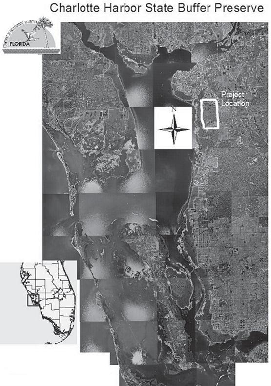
2 Charlotte Harbor Preserve State Park County: Charlotte, Lee PCL Size: 43,614 acres Project ID: SW acres $112,500 Project ID: MR acres $99, Project Manager: Florida Park Service (DEP) John Aspiolea, Assistant Park Manager Burnt Store Road, Punta Gorda, Florida Phone: , Fax: The first project (SW-063) completed initial control of cogon grass on the Punta Gorda management unit of Charlotte Harbor Preserve State Park. The project site is a mixture of pine flatwoods, hardwood hammocks, and isolated wetlands, grading into coastal wetlands and mangroves. A network of drainage ditches divides the uplands. This ditching affected the hydrology of many of the wetlands, creating conditions ripe for exotic plant invasion. Melaleuca, Brazilian pepper, climbing fern, shoebutton ardisia, downy rose-myrtle, and West African orchid also infested the site. The project area contained just over 500 acres of flatwoods and hammocks invaded by cogon grass. Cogon grass also invaded some of the spoil banks along the ditches. In a few locations, cogon grass formed a dense monoculture, but for the most part the plant occurred as scattered clumps or individual sprigs throughout the flatwoods. BIPM funded this project in its entirety. The second project (MR-008) was on the Cape Coral management unit, which consists of wetlands at the mouth of the Caloosahatchee River and the shoreline of Matlacha Pass. Spreader waterways in Cape Coral were designed to capture excess water from the canals and allow the water to sheet flow into the adjacent wetlands. These wetlands are part of the Park and include high marsh, salt flats, coastal berm, and mangroves. Seaside mahoe, Brazilian pepper, and Australian pine encroached into coastal berms along the shorelines of Matlacha Pass and the mouth of the Caloosahatchee River, as well as on coastal islands in Matlacha Pass within the Park. This project included a second work site at Yucca Pen, a large slough system north of Cape Coral. When drainage from the slough approaches Charlotte Harbor near Burnt Store Road, the sheet flow becomes channelized into Yucca Pen Creek and several unnamed creeks that pass through the Park. Seaside mahoe and Brazilian pepper were controlled in these watersheds and along the shoreline of Charlotte Harbor. The Florida Park Service fully funded this project. Imperata cylindrica cogon grass Category I foliar Roundup Schinus terebinthifolius Brazilian pepper Category I cut stump Garlon 4 Thespesia populnea seaside mahoe Category I cut stump Garlon 4 97
3 98


4 Examples of cogon grass infestation at CHPSP Dense cogon grass patch at Charlotte Harbor Preserve State Park Sparse cogon grass infestation at Charlotte Harbor Preserve State Park 99
 Reggie Norman, Park Manager 880 Belcher Road, P. O.")
 program.")
5 Barrier Island GEOpark County: Charlotte Don Pedro Island State Park PCL Size: 229 acres Stump Pass Beach State Park PCL Size: 231 acres Project ID: RP acres $50,000 Project Manager: Florida Park Service (DEP) Reggie Norman, Park Manager 880 Belcher Road, P. O. Box 1150, Boca Grande, Florida Phone: , Fax: Acquisition of Don Pedro Island State Park began in 1985 under the Land Acquisition Trust Fund (LATF) program. The natural communities of Don Pedro include marine tidal swamp, mesic flatwoods, and coastal strand. The state acquired Stump Pass Beach State Park in 1971 through the LATF and the federal Land and Water Conservation Fund. The natural communities of Stump Pass consist primarily of maritime hammock and estuarine tidal swamp. The rest of the property is beach dune, coastal strand, and marine unconsolidated substrate. This project was paid for entirely through Florida Park Service funding. Casuarina equisetifolia Australian pine Category I basal/girdle Garlon 4 Melaleuca quinquenervia melaleuca Category I cut stump Arsenal Schinus terebinthifolius Brazilian pepper Category I basal Garlon 4 100

6 Fakahatchee Strand Preserve State Park County: Collier PCL Size: 70,376 acres Project ID: SW-060 2,401 acres $65,380 Project Manager: Florida Park Service (DEP) Mike Owen PO Box 548, Copeland, Florida Phone: , Fax: The project site was primarily located on the west side of the preserve where natural communities include pine flatwoods, rockland hammock, prairie hammock, cypress swamp, and marl prairie. Brazilian pepper was located in Section 24 in the recently acquired southwest portion of the preserve, which was an abandoned goat and pig farm and former migrant camp, and in the northern half of Section 26 south of Prairie Canal. The filling of the northern four miles of Prairie Canal facilitated access for control of Brazilian pepper in this area. Schinus terebinthifolius Brazilian pepper Category I basal Garlon 4 Schinus terebinthifolius Brazilian pepper Category I foliar Roundup+Amm. Sulfate 101
 Joe Howard, Park Manager 20200 Tamiami Trail East, Naples, Florida 34114 Phone: 239-394-3397, Fax: 239-394-5113 E-mail: joe.howard@dep.state.")
7 Collier-Seminole State Park County: Collier PCL Size: 7,271 acres Project ID: SW acres $2,945 Project Manager: Florida Park Service (DEP) Joe Howard, Park Manager Tamiami Trail East, Naples, Florida Phone: , Fax: Collier-Seminole State Park features a wealth of vegetation and wildlife that is typical of the Everglades region of Florida. A tropical hammock dominated by trees that are characteristic of coastal forests of the West Indies and Yucatan is a special feature of the park. Also, the rare Florida royal palm is a common species here. Natural communities of the park include extensive mangrove swamp, as well as cypress swamp, hydric hammock salt marsh, and mesic pine flatwoods. This project primarily targeted Old World climbing fern on nine acres of mesic pine flatwoods. A smaller flatwoods site was treated for melaleuca. BIPM provided the herbicide only for this project through its Herbicide Bank. Lygodium microphyllum Old World climbing fern Category I foliar Rodeo Melaleuca quinquenervia melaleuca Category I cut stump Arsenal 102
8 Picayune Strand State Forest County: Collier PCL Size: 65,436 acres Project ID: SW acres $80,000 Project Manager: Division of Forestry (FDACS) Sonja Durrwachter, Forestry Supervisor II nd Ave SE, Naples, Florida Phone: , Fax: Picayune Strand State Forest is comprised of two adjacent Conservation and Recreation Lands (CARL) purchases, South Golden Gate Estates (SGGE) to the east and Belle Meade to the west. The forest is bordered to the east by Fakahatchee State Preserve and to the south by Collier-Seminole State Park and Ten Thousand Islands National Wildlife Refuge. The forest encompasses a wide variety of habitats, including cypress sloughs, pine flatwoods, hammocks, and grass prairies. The project area was the Belle Meade tract in an area previously treated by the lacing method in Schinus terebinthifolius Brazilian pepper Category I basal/mechanical Garlon 4 103
9 Florida Panther National Wildlife Refuge County: Collier PCL Size: 26,529 acres Project ID: SW acres $106, Project Manager: U.S. Fish and Wildlife Service Dennis Giardina State Road 29 S, Immokalee, Florida Phone: x 29 dennis_giardina@fws.gov This project controlled scattered infestations of Old World climbing fern, Lygodium microphyllum (lygodium), on the Florida Panther National Wildlife Refuge (Refuge). Cypress forest and mixed swamp communities comprised the majority of the affected habitat. Much of the treatment area was impacted by canal digging and railroad tram building related to timber extraction during the middle of the previous century. The project area lay in the southeast corner of the Refuge. Contractors worked from outlying infestations towards the densest infestations in several separate areas. Outlier lygodium infestations were identified by Refuge staff in the field and on maps. The Refuge also provided staff time and vehicles as an in-kind match worth $10,000. Lygodium microphyllum Old World climbing fern Category I foliar Aquaneat+Escort 104
 Pamela Keyes, Resource Management Specialist 300 Tower Road, Naples, Florida 34113 Phone: 941-417-6310, Fax: 941-417-6315 Email:")
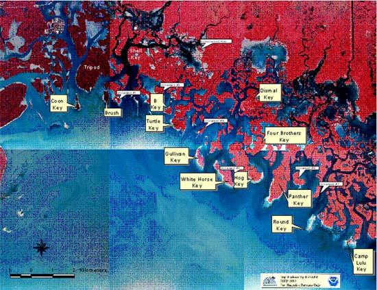
10 Ten Thousand Islands County: Collier PCL Size: 8,630 acres Project ID: SW-064 2,000 acres $40, Project ID: SW acres $40, Project Manager: Office of Coastal and Aquatic Managed Areas (DEP) Pamela Keyes, Resource Management Specialist 300 Tower Road, Naples, Florida Phone: , Fax: The Ten Thousands Islands are approximately 8,630 acres with 6,200 acres designated as a National Wildlife Refuge (managed by the US Fish and Wildlife Service) and 2,430 acres designated as a state Aquatic Preserve. Native communities that comprise the Ten Thousand Islands include beach, dune, mangrove forests, costal strand, tropical hardwood hammocks, sea grass beds, and oyster reefs. The first project provided initial control of Brazilian pepper in brackish wetlands of the Ten Thousand Islands National Wildlife Refuge. The project site was a 2,000-acre wetland area where mangrove forest transitions into a largely open mixed wetland. This unique zone is comprised of five percent tropical hardwood hammocks, thirty-five percent mangroves, and sixty percent emergent marsh. Brazilian pepper encroached throughout the area and was especially concentrated around the tropical hammocks and high marsh. The second project targeted all Category I and II invasive plants on twenty-three islands within the Ten Thousand Islands for maintenance control. Past initial treatment and maintenance control funded by BIPM, along with work by volunteers and staff, occurred on Shell Key, Tripod Key, Coon Key, Dismal Key Four Brothers Key, Hog Key, Camp LuLu, Whitehorse Key, Panther Key, Gullivan Key, Round Key, Brush Island, Turtle Key, Faka-Union Canal, Buttonwood Key B Key, Unnamed Island #1, Unnamed Island #2, Unnamed Island #4, Unnamed Island #5, Unnamed Island #6, Unnamed Island #7 and Fakahatchee Island. Colubrina asiatica latherleaf Category I basal Garlon 4 Melaleuca quinquenervia melaleuca Category I cut stump Chopper Schinus terebinthifolius Brazilian pepper Category I basal Garlon 4 Hibiscus tiliaceus mahoe Category II basal Garlon 4 Kalanchoe pinnata life plant Category II foliar Ranger Pro 105
11 106
12 Rookery Bay National Estuarine Research Reserve County: Collier PCL Size: 110,000 acres Project ID: MR acres $113,300 Project Manager: Office of Coastal and Aquatic Managed Areas (DEP) Keith Laakkonen, Resource Management Coordinator 300 Tower Road, Naples, Florida Phone: x212, Fax: Rookery Bay NERR is located ten miles southeast of Naples, Florida. The Reserve has a northern boundary at Gordon Pass and a southern boundary at Camp LuLu Key in the Ten Thousand Islands. Rare and endangered plants occurring in the Reserve area include barbed wire cactus, satinleaf, wild cotton, bay cedar, common wild pine, giant wild pine, and many-flowered grass pink. The project site is south of Henderson Creek adjacent to SR 951 (Collier Boulevard). Henderson Creek is a major source of freshwater flow into Rookery Bay. The Henderson Creek Restoration project requires the removal and control of all invasive plant species. The target zones comprise pine flatwoods and high coastal marsh with fringing mangrove forest along tidally influenced Henderson Creek. The project area consisted of three different zones. Zone 1, a 5-acre site located directly next to a mangrove restoration site, was heavily infested with Brazilian pepper, earleaf acacia and wedelia. Zone 2, an approximately 24-acre site, was heavily infested with downy rose-myrtle, some melaleuca, thick Brazilian pepper along the mangrove ecotone, and lygodium. Zone 3, an approximately 21-acre site, was heavily infested with downy rose-myrtle, air-potato, earleaf acacia, and Brazilian pepper. Additionally, maintenance control was conducted on the 20-acre Krantz parcel, which was previously heavily infested with downy rose-myrtle and melaleuca. This parcel received initial control in All control work was contracted through CAMA funding. Acacia auriculiformis earleaf acacia Category I basal Garlon 4 Lygodium microphyllum Old World climbing fern Category I foliar Roundup+Amm. Sulfate Rhodomyrtus tomentosa downy rose-myrtle Category I foliar Roundup+Amm. Sulfate Schinus terebinthifolius Brazilian pepper Category I basal Garlon 4 Urena lobata Caesar s weed Category II foliar Roundup+Amm. Sulfate 107

13 Sanibel Island/Bowman s Beach Park County: Lee PCL Size: 170 acres Project ID: SW acres $131,200 Project Manager: City of Sanibel Department of Natural Resources Robert Loflin, Ph.D., Natural Resources Director 800 Dunlop Road, Sanibel, Florida Phone: , Fax: Rob.Loflin@mysanibel.com The passage of Hurricane Charley forever changed the landscape of Sanibel Island. The high winds associated with the storm left much of the island vegetation damaged or destroyed. Bowman s Beach lost thousands of Australian pines as a result of the hurricane season. In addition, numerous boardwalks, the fitness trail, picnic tables, and parking lots were heavily damaged. This project assisted the City in removal of trees from the park. The City of Sanibel and Lee County provided matching funds of $80,000 and $180,000 respectively, for removal and treatment work for a total project cost of $391,200. The City also received assistance from FEMA and USFWS. In all, Australian pines were removed from 370 acres of Sanibel Island. Casuarina equisetifolia Australian pine Category I mechanical n/a 108 Somewhere under these trees is a house. The invasive Australian pine threatens both people and nature.


14 Sanibel Island/Bowman s Beach Park Australian pines grow over 100 feet tall and have a dense hard wood. This requires specialized (and expensive) heavy equipment to topple and cut the trees, which then... must be carried off for disposal... by burning... or by chipping. 109
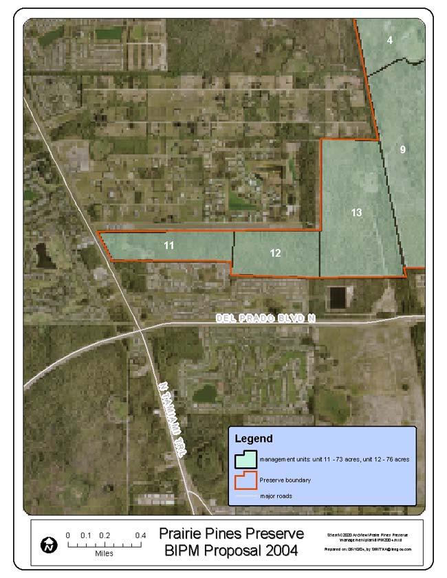
15 Prairie Pines Preserve County: Lee PCL Size: 2,709 acres Project ID: SW acres $153,000 Project Manager: Lee County Parks and Recreation Anik L. Smith, Land Stewardship Supervisor 3410 Palm Beach Boulevard, Fort Myers, Florida Phone: , Fax: Prairie Pines Preserve is the largest preserve owned and managed by Lee County. The preserve encompasses diverse native plant communities that provide habitat for several listed animals and seven listed plant species. Over four hundred species of native plants are documented on the preserve. Lee County Parks and Recreation provided $481,980 in matching funds for this project. The county divided the preserve into nineteen management units to make management and restoration projects easier. Units 11 and 12 were the first two units targeted for invasive exotic plant control since they are the location of the preserve entrance and most of the public use facilities such as trailhead, parking, and overlook. Management Unit 11 is 73 acres of primarily mesic pine flatwoods, prairie hammock and depression marsh. The mesic flatwoods were infested by melaleuca with twenty-five to fifty percent coverage. The depression marsh was ringed by a melaleuca monoculture that was beginning to invade the center of the marsh. Torpedo grass formed approximately twenty-five percent of the ground cover within the marsh. The prairie hammock was infested by Brazilian pepper with coverage of fifty to seventy-five percent. Management Unit 12 is 76 acres of mesic and wet pine flatwoods with twenty-five to fifty percent coverage of melaleuca. Downy rose-myrtle occurred at a relatively low density of less than five percent throughout the mesic and wet flatwoods of both management units. A Brontosaurus mower was used in the mesic and wet flatwoods to mulch melaleuca down to grade. A combination of biological and chemical control will be used for maintenance control of resprouts. Both the melaleuca snout weevil and psyllid already occur at the preserve and quickly attack fresh growth. Melaleuca within the depression marsh was cut with chainsaws, felled trees stacked, and stumps treated with an appropriate chemical mixture. Melaleuca quinquenervia melaleuca Category I mechanical Garlon 3A Panicum repens torpedo grass Category I foliar Rodeo Rhodomyrtus tomentosa downy rose-myrtle Category I mechanical Garlon 4 Schinus terebinthifolius Brazilian pepper Category I mechanical Garlon 4 110
16 111


17 Prairie Pines Preserve Before and after pictures taken about two months apart show how melaleuca dominates the landscape. If the natural community was wiped out by the melaleuca, restoration work will include replanting of native species. Downy rose-myrtle, while not quite as bad as melaleuca, will also overwhelm native species. After removal of the invasive species, this native pine flatwoods looks just about right. 112
Southwest Regional Working Group
 Southwest Regional Working Group The Southwest Regional Working Group liaison is Roger Clark, Lee County Parks and Recreation, 3410 Palm Beach Boulevard, Ft. Myers, Florida 33916, phone: 941-338-3343,
Mosquito Coast Regional Working Group
 Mosquito Coast Regional Working Group Merritt Island Invasive Exotic Plant Control Projects PCL: Merritt Island National Wildlife Refuge Project Manager: U.S. Fish and Wildlife Service Ron Hight, Refuge
MANAGEMENT STATUS REPORT FOR CONSERVATION 20/20 PRESERVES QUARTER 1 REPORT (October - December 2017) February 8, 2018
 February 8, 2018") CAPE CORAL, PINE ISLAND, SANIBEL and MATLACHA PASS AREAS Charlotte Harbor Buffer Preserve 446 acres adjacent to Charlotte Harbor Preserve State Park Nominations 58, 91, 95, 96, 99, 137, 262, 280, 372,
CAPE CORAL, PINE ISLAND, SANIBEL and MATLACHA PASS AREAS Charlotte Harbor Buffer Preserve 446 acres adjacent to Charlotte Harbor Preserve State Park Nominations 58, 91, 95, 96, 99, 137, 262, 280, 372,
MANAGEMENT STATUS REPORT FOR CONSERVATION 20/20 PRESERVES FY QUARTER 1 REPORT (October-December 2018) January 10, 2018
 January 10, 2018") CAPE CORAL, PINE ISLAND, SANIBEL and MATLACHA PASS AREAS Charlotte Harbor Buffer Preserve 448.61 acres adjacent to Charlotte Harbor Preserve State Park Nominations 58, 91, 95, 96, 99, 137, 262, 280, 372,
CAPE CORAL, PINE ISLAND, SANIBEL and MATLACHA PASS AREAS Charlotte Harbor Buffer Preserve 448.61 acres adjacent to Charlotte Harbor Preserve State Park Nominations 58, 91, 95, 96, 99, 137, 262, 280, 372,
Pinellas County Environmental Lands
 Pinellas County Environmental Lands In addition to traditional parks and recreation facilities, Pinellas County owns and manages a system of environmental lands that provides specialized resource-based
Conservation Lands. Conservation Lands Advisory Committee October 19, 2005
 Conservation Lands Advisory Committee October 19, 2005 Roland DeBlois Chief of Environmental Planning & Code Enforcement Community Development Department Beth Powell Conservation Lands Manager Parks Division
 MANAGEMENT STATUS REPORT FOR CONSERVATION 20/20 PRESERVES July 2012 (April 1 June 30) July 2012 CAPE CORAL, PINE ISLAND, and MATLACHA PASS AREAS Charlotte Harbor Preserve 400 acres C20/20 Preserves adjacent
MANAGEMENT STATUS REPORT FOR CONSERVATION 20/20 PRESERVES QUARTER 3 REPORT (April-June 2016) August 11, 2016
 August 11, 2016") CAPE CORAL, PINE ISLAND, SANIBEL and MATLACHA PASS AREAS Charlotte Harbor Preserve 446 acres C20/20 Preserves adjacent to Charlotte Harbor Preserve State Park Nominations 58, 91, 95, 96, 99, 137, 262,
CAPE CORAL, PINE ISLAND, SANIBEL and MATLACHA PASS AREAS Charlotte Harbor Preserve 446 acres C20/20 Preserves adjacent to Charlotte Harbor Preserve State Park Nominations 58, 91, 95, 96, 99, 137, 262,
East Central Regional Working Group
 East Central Regional Working Group The East Central Regional Working Group liaison is Gregg Walker, 2849 Babylon Court, Oviedo, Florida 32765, phone: 407-359-0506, e-mail: asligregg@aol.com 13 Lake Tohopekaliga
MANAGEMENT STATUS REPORT FOR CONSERVATION 20/20 PRESERVES QUARTER 3 REPORT (April - June 2018) July 12, 2018
 July 12, 2018") CAPE CORAL, PINE ISLAND, SANIBEL and MATLACHA PASS AREAS Charlotte Harbor Buffer Preserve 446 acres adjacent to Charlotte Harbor Preserve State Park Nominations 58, 91, 95, 96, 99, 137, 262, 280, 372,
CAPE CORAL, PINE ISLAND, SANIBEL and MATLACHA PASS AREAS Charlotte Harbor Buffer Preserve 446 acres adjacent to Charlotte Harbor Preserve State Park Nominations 58, 91, 95, 96, 99, 137, 262, 280, 372,
Brooker Creek Preserve Management Plan 2008 Update
 Brooker Creek Preserve Management Plan 2008 Update Plan approved by the Board of County Commissioners Pinellas County, Florida 19 August 2008 Pinellas County Department of Environmental Management Environmental
Guide to Local Activities
 Guide to Local Activities We welcome you to Naples and the Vineyards! Naples is a wonderful place to visit and live. Our coast has everything you can possibly want from pristine beaches and island getaways
Southeast Regional Working Group
 Southeast Regional Working Group The Southeast Regional Working Group liaison is Joe Maguire, Miami-Dade Parks and Recreation, 22200 S.W. 137 th Avenue, Miami, Florida 33170, phone: 305-257-0933, fax:
SOUTH SECTION TRAIL SITES as of Mon Oct
 SOUTH SECTION TRAIL SITES as of Mon Oct. 16 2017 Partial Site is open but some hiking trails/facilities may be closed Closed Site is closed until further notice Open Site is open Unknown We have no information
Wetlands Reservoirs of Biodiversity. Billy McCord, SCDNR
 Wetlands Reservoirs of Biodiversity Billy McCord, SCDNR Estuaries Tidal Deepwater Intertidal Salt Marsh Tidal Riverine Fresh & Brackish Deepwater Tidal Emergent Marsh Freshwater Riverine Seasonally Flooded
Florida Department of Environmental Protection Division of Recreation and Parks
 Florida Department of Environmental Protection Division of Recreation and Parks Land Honeymoon Island State Park Introduction Honeymoon Island State Park is a 2,810.16-acre public outdoor recreation and
Annual maintenance figures include areas that were re-treated in previous years, so the cumulative acreage is greater than the estimated total area
 1 Annual maintenance figures include areas that were re-treated in previous years, so the cumulative acreage is greater than the estimated total area infested. MANAGER COST ACRES Cities $501,169 1,201
3.0 EXISTING PARK & RECREATION SPACE
 3.0 EXISTING PARK & RECREATION SPACE TOWN PARK & RECREATION SPACE An inventory of current parks and recreation area in the Town of Cedarburg is shown in Table 3. These areas total roughly 381.89 acres.
Biodiversity is life Biodiversity is our life
 Biodiversity is life Biodiversity is our life Chapter 10 Section 2 Biodiversity at Risk Objectives Define and give examples of endangered and threatened species. Describe several ways that species are
Case Study: 1. The Clarence River Catchment
 Case Study: 1. The Clarence River Catchment The NSW coastline is a great natural asset, making an enormous contribution to the economy. The resources of coastal catchments such as the Clarence River Catchment,
STORNETTA BROTHERS COASTAL RANCH
 STORNETTA BROTHERS COASTAL RANCH Location: Surrounding Point Arena Lighthouse and immediately south of Manchester State Park Mendocino Co., CA Acres: 1,860 Resources: Over two miles of Pacific Ocean coastline
Toll Rates for Florida Turnpike System and Florida Department of Transportation (FDOT) Toll Facilities. South Florida
 Toll Facilities. South Florida") Toll Rates for Florida Turnpike System and Florida Department of Transportation (FDOT) Toll Facilities South Florida Effective: October 29, 207 S.R. 82 (HEFT) Miami-Dade and Broward Counties S.R. 82 (HEFT)
Toll Rates for Florida Turnpike System and Florida Department of Transportation (FDOT) Toll Facilities South Florida Effective: October 29, 207 S.R. 82 (HEFT) Miami-Dade and Broward Counties S.R. 82 (HEFT)
Figure 7. Dragline at Cape Coral, Figure 8. Cape Coral oblique aerial photograph, 1959.
 The dredge-and-fill method, which would later be criticized for its environmental impact, employed in the peak years of the early 1960s as many as four dredges and ten draglines, which at times operated
Rock Creek State Park
 Rock Creek State Park Rock Creek State Park Rock Creek State Park, located five miles west of Grinnell, consists of a large man-made lake and a surrounding fringe of land. There are several access points
2018 Resource & Relocation Guide
 Florida 2018 Resource & Relocation Guide 1 2 3 4 Table of Contents 5 6-7 Newcomer Information 22 Home Buyer Information 8 Help Hotlines 25 Buyer Mistakes 9 Health & Hospitals 27 How Much Can You Afford
HAROLD E. ALEXANDER SPRING RIVER WILDLIFE MANAGEMENT AREA
 HAROLD E. ALEXANDER SPRING RIVER WILDLIFE MANAGEMENT AREA HAROLD E. ALEXANDER SPRING RIVER WILDLIFE MANAGEMENT AREA Prepared by: Randy Brents Jr (Fire Management Officer) Dallas Harrell (Area Biologist)
Non-motorized Trail Plan & Proposal. August 8, 2014
 Town of Star Valley Ranch, Wyoming and the Star Valley Ranch Association in partnership with the USDA Forest Service, Bridger-Teton National Forest, Greys River Ranger District Non-motorized Trail Plan
Florida Department of Environmental Protection Division of Recreation and Parks
 Florida Department of Environmental Protection Division of Recreation and Parks Land Edward Ball Wakulla Springs State Park Introduction Edward Ball Wakulla Springs State Park is a 6,055.2-acre public
Shores Nature Trail Park
 Shores Nature Trail Park Revised /0 A B C D E F G H I Burnt Store Rd Del Prado Blvd Fowler St Ortiz Ave Davis rd Charlotte County Barrancas Ave Del Prado Blvd Slater Rd Bayshore Rd Nalle Grade Rd Exit
IOWA ORNITHOLOGISTS' UNION - Birding Sites in Dallas County
 IOWA ORNITHOLOGISTS' UNION - Birding Sites in Dallas County Printed on 7/19/2018 Beaver Bottoms Wetland (restricted) (Important Bird Area) GPS Coordinates:, Ownership: Private (see directions for access)
Appendix A Appendix A (Project Specifications) Auk Auk / Black Diamond (Trail 44) Reroute
 Auk Auk / Black Diamond (Trail 44) Reroute") Appendix A (Project Specifications) Auk Auk / Black Diamond (Trail 44) Reroute I. Proposed Action: This project proposes to reroute approximately 1,800 feet of a 50 inch wide trail, off of private property
Appendix A (Project Specifications) Auk Auk / Black Diamond (Trail 44) Reroute I. Proposed Action: This project proposes to reroute approximately 1,800 feet of a 50 inch wide trail, off of private property
$850,000 Awarded to 20 Organizations
 $850,000 Awarded to 20 Organizations The Conservation Alliance is pleased to fund the following organizations to support their efforts to protect wild lands and waterways for their habitat and recreation
FLORIDA DEPARTMENT OF ENVIRONMENTAL PROTECTION DIVISION OF RECREATION AND PARKS RECREATIONAL CARRYING CAPACITY GUIDELINES
 FLORIDA DEPARTMENT OF ENVIRONMENTAL PROTECTION DIVISION OF RECREATION AND PARKS RECREATIONAL CARRYING CAPACITY GUIDELINES THE SELECTION AND CAPACITY DETERMINATION OF USE SITES Introduction The Division
Newsletter #59 July 2008
 4 th of July parade Photos included. If the address label on this Newsletter is GREEN it is time to renew your membership. Use the enclosed envelope and the form on the last page to renew. New pine trees
Deering Estate Camp. Field Trip total: $ 5.00 Monday Tuesday Wednesday Thursday Friday. Campers will explore
 Discover Deering Campers will dive into the mission of the Deering Estate which is dedicated to preserving and protecting the natural, archaeological, architectural and historic legacy of the land. WEEK
MARINE PROTECTED AREAS LESSON PLAN Water Parks
 Marine Protected Areas U. S. Marine Protected Areas Lesson Plan MARINE PROTECTED AREAS LESSON PLAN Water Parks Theme U.S. Marine Protected Areas Links to Overview Essays and Resources Needed for Student
5 proposed wetland sites
 PROPOSED WETLAND SITES OF VIETNAM Hoang Van Thang, PhD. 5 proposed wetland sites 1. Lak Lake 2. Lo Go Sa Mat 3. Tram Chim 4. UMi Minh hthuong 5. Mui Ca Mau Lak Lake Coordinates: 12o24 22 12o26 25 N 108o09
IMPACTS OF THE RECENT TSUNAMI ON THE BUNDALA NATIONAL PARK THE FIRST RAMSAR WETLAND IN SRI LANKA
 IMPACTS OF THE RECENT TSUNAMI ON THE BUNDALA NATIONAL PARK THE FIRST RAMSAR WETLAND IN SRI LANKA by C.N.B. Bambaradeniya, IUCN The World Conservation Union, Sri Lanka Country Office (Email: cnb@iucnsl.org)
Conservation Area Management Statement
 Conservation Area Management Statement Miller Creek Wildlife Area Resolution #: Approval: Issue Date: Date of Last Revision: Table of Contents 1. Purpose....... 1 2. Property Description...... 1 2.1. Legal
CREW Cypress Dome Trails Self-Guided Tour
 CREW Cypress Dome Trails Self-Guided Tour The numbers in this guide correspond to numbers on the Cypress Dome Trail Map (included in this guide below) and to the brown number plates fastened to marker
On the Edge with Mangroves
 On the Edge with Mangroves (Author s Note: This is the twenty-second in a series of articles by members of the City of Sanibel Vegetation Committee dealing with vegetative matters of concern to island
Mangroves In The Southern Florida U S Fish And
 We have made it easy for you to find a PDF Ebooks without any digging. And by having access to our ebooks online or by storing it on your computer, you have convenient answers with mangroves in the southern
Lecture 08, 22 Sep 2003 Role Playing. Conservation Biology ECOL 406R/506R University of Arizona Fall Kevin Bonine
 Lecture 08, 22 Sep 2003 Role Playing Conservation Biology ECOL 406R/506R University of Arizona Fall 2003 Kevin Bonine 1. Role Playing Exercise 2. Exam Wed -group portion outside - ~40 minutes individual,
OWNED LAND ACTIVITIES REPORT February 2012
 OWNED LAND ACTIVITIES REPORT February 2012 BULL RUN MOUNTAINS NATURAL AREA PRESERVE A tremendous number of projects are underway on the Preserve. Currently VOF is working with the Smithsonian Conservation
WHAT PEOPLE ARE SAYING
 WHAT PEOPLE ARE SAYING As essential as sunscreen and a must-have for anyone visiting or living in South Florida. MAC STONE, author of Everglades: America s Wetland An alluring snapshot, capturing the regions
566± acres total - WILL DIVIDE Volusia County, FL
 L IC E N S E D HUNTING P RESERVE ts Q u a i l ahi ul anb l e are av r info! fo CALL TODAY LAKEFRONT PROPERTY PERFECTION This ranch lies on a natural sand ridge in North Volusia County, Florida and has
proof Northwest District
 1 Northwest District The Northwest Florida Water Management District is the most rural of all five water management districts. From just east of Tallahassee west to the Florida/Alabama line, and from the
USDA Forest Service Deschutes National Forest DECISION MEMO. Round Lake Christian Camp Master Plan for Reconstruction and New Facilities
 USDA Forest Service Deschutes National Forest DECISION MEMO Round Lake Christian Camp Master Plan for Reconstruction and New Facilities Jefferson County, Oregon T. 13 S., R. 8 E., Section 16, W.M. Background:
Malua Biobank Operations Report. Submitted by the Sabah Forestry Department May June 2009
 Malua Biobank Operations Report Submitted by the Sabah Forestry Department May 2009 - June 2009 Protection Boundary monitoring and patrol, gate installations, signage installation and maintenance, night
Appendix C. Past and Current Management of Selected Tidal Wetland Sites
 Appendix C. Past and Current Management of Selected Tidal Wetland Sites Maps and photographs of wetland sites can be found at http://www.elkhornslough.org/tidalwetlandproject. Site 1. Parsons Slough/South
Restoring Great Waters & National Parks for the 2nd Century of the National Park System: A National Overview
 Restoring Great Waters & National Parks for the 2nd Century of the National Park System: A National Overview John Adornato Conference on Ecological and Ecosystem Restoration New Orleans July 29, 2014 National
IOWA ORNITHOLOGISTS' UNION - Birding Sites in Cerro Gordo County
 IOWA ORNITHOLOGISTS' UNION - Birding Sites in Cerro Gordo County Printed on 11/17/2018 Blue-wing Marsh GPS Coordinates: 43.0834956379463,-93.4430980682373 Pure natural area primarily used for hunting.
History of the Florida Society for Ethical Ecotourism
 History of the Florida Society for Ethical Ecotourism 1998 CREW Land & Water Trust and the FDEP Rookery Bay National Estuarine Research Reserve receive a grant from The Advisory Council of Environmental
Welcome to Marco Island
 Marco Island is located in Southwest Florida, on the Gulf of Mexico, 178 miles south of Tampa,16 miles south of Naples, and 104 miles due west of Miami. Marco is the northern most and largest of the famous
X. WHATCOM CREEK SMA. X.1 Watershed Analysis. X.1.1 Landscape Setting
 X. WHATCOM CREEK SMA Summary: The entire length of Whatcom Creek is located within the City of Bellingham. SMA jurisdiction associated with this creek is approximately 300 acres. Land use is dominated
Frond Forum Florida Native Plant Society Cuplet Fern Chapter :: Seminole County
 Florida Native Plant Society Cuplet Fern Chapter :: Seminole County 2013 14 Board President: Beth Jackson Vice President: Sherry Williams Secretary: Christine Brown Treasurer: Susan Blount-Angermeier Chapter
Lewis and Clark National Historic Trail
 National Trails System Land and Water Conservation Fund FY2014 Lewis and Clark National Historic Trail Total LWCF Request: $ 3,130,000 Project Name Agency District # Tracts Acres Total Cost Columbia River
NATIONAL PARKS IN PERIL
 NATIONAL PARKS IN PERIL THE THREATS OF CLIMATE DISRUPTION State Fact Sheet: Florida Human disruption of the climate is the greatest threat ever to our national parks. At risk are nearly every resource
Town of Oakfield Agricultural and Farmland Protection Plan
 SECTION III COMMUNITY OVERVIEW A. Regional Setting / Location The Town of Oakfield is located in the northwestern portion of Genesee County. Located west of New York's Finger Lakes, the Town is uniquely
photos Department of Environment and Conservation Biodiversity Conservation
 photos Department of Environment and Conservation Biodiversity Conservation EcoEducation - making the connections to biodiversity conservation Do you consider experiential learning of biodiversity in the
Spatial Distribution and Characteristics of At-Risk Species in the Southeast U.S.
 Nicholas Institute for Environmental Policy Solutions Scoping Document Part 2 Exploratory Analysis of Characteristics and Trends of At-Risk Species in the Southeast U.S. Spatial Distribution and Characteristics
THOMAS A. SWIFT METROPARK Introductions History Present Conditions Future Development Plans Implementation Strategies Statistics
 THOMAS A. SWIFT METROPARK Introductions History Present Conditions Future Development Plans Implementation Strategies Statistics Introduction As an open meadow park positioned along the Mahoning River,
Things To Do, Places to Go
 Food Stores, etc: Things To Do, Places to Go Publix 4791 Estero Boulevard. It has a good selection, similar prices as off island, handy for beer and wine watch for specials. Topps - at Tropical Shores
April 10, Mark Stiles San Juan Public Lands Center Manager 15 Burnett Court Durango, CO Dear Mark,
 Mark Stiles San Juan Public Lands Center Manager 15 Burnett Court Durango, CO 81301 Dear Mark, We are pleased to offer the following comments on the draft San Juan Public Lands Center management plans
Attachment D: PHOTO LOG CITY OF ARCATA RAIL-WITH-TRAIL CONNECTIVITY PROJECT
 01051-09004 Attachment D: PHOTO LOG CITY OF ARCATA RAIL-WITH-TRAIL CONNECTIVITY PROJECT DRAFT: June 30, 2010 Applicant: City of Arcata 736 F Street Arcata, CA 95521 Phone (707) 825-2154 Prepared by: Winzler
MCARTHUR SWAMP PLANNING UNIT Pit-McCloud River Watershed
 Existing Conditions & Uses Overview Spring-fed lake and rivers; valuable grazing lands and important waterfowl area Planning unit provides the only public access to Ahjumawi Lava Springs State Park 7,596
FINGER-TATUK PROVINCIAL PARK
 FINGER-TATUK PROVINCIAL PARK PURPOSE STATEMENT AND ZONING PLAN March 2003 FINGER-TATUK PROVINCIAL PARK Purpose Statement and Zoning Plan Finger-Tatuk Provincial Park is 17,151 ha in size. It includes the
Boca Creek Acre Development Site , & Gasparilla Rd, Placida, FL
 Boca Creek 153 + Acre Development Site AREA AMENITIES BOCA CREEK 153.15 Acre Development Site Gasparilla Rd Placida Rd Gasparilla Rd 2 Marina & Boat Ramps Boca Grande Causeway
Bratt ") 4. % F l o r i d a D e s i g n a t e d P a d d l i n g T r a i l s ") 164 «97 ") 99. Barrineau Park. M a p 1. M a p 2.
 4. % F l o r i d a D e s i g n a t e d P a d d l i n g T r a i l s ) 164 «97 ) 99. Barrineau Park. M a p 1. M a p 2.") F l o r i d a D e s i g n a t e d P a d d l i n g T r a i l s Bratt ") 4 Bluff Springs «4 Jay ") P e r d i d o R i v e r P e r d i d o CR R99A i v Walnut e r Hill ") 164 ") 97A «89 «97 ") 197 Barrineau
F l o r i d a D e s i g n a t e d P a d d l i n g T r a i l s Bratt ") 4 Bluff Springs «4 Jay ") P e r d i d o R i v e r P e r d i d o CR R99A i v Walnut e r Hill ") 164 ") 97A «89 «97 ") 197 Barrineau
a place of exceptional natural beauty
 Mission Beach a place of exceptional natural beauty Where the rainforest grows right down to the sea And where you have the best chance of seeing a cassowary in the wild Tourism is the main industry at
STREAKED HORNED LARK. Conservation of a threatened species in an industrial landscape. Cat Brown US Fish and Wildlife Service
 STREAKED HORNED LARK Conservation of a threatened species in an industrial landscape Cat Brown US Fish and Wildlife Service HISTORICAL & CURRENT RANGE Streaked Horned Lark Distribution Historical Range:
Conservation Results In An Urban Environment Through Public-Private Partnerships
 Conservation Results In An Urban Environment Through Public-Private Partnerships James Boase, U.S. Fish and Wildlife Service Supporting Contributors John Hartig, USFWS Allison Krueger, USFWS Ed Roseman,
Phoenix Habitat Restoration Projects
 Phoenix Habitat Restoration Projects Spur Cross Ranch Cave Creek (Estergard) Regional Tree and Shade Summit March 9, 2010 Desert Riparian Ecosystems Healthy riparian areas like this once existed along
Bear Creek Habitat Improvement Project
 06/10/10 Bear Creek Habitat Improvement Project El Paso County, Colorado Pike National Forest and Colorado Springs Utilities Owned Land Report prepared by: Eric Billmeyer Executive Director Rocky Mountain
Bayview Escarpment. Interim Management Statement
 Bayview Escarpment Interim Management Statement Bayview Escarpment Provincial Nature Reserve Interim Management Statement January 15, 1995 REGIONAL DIRECTOR'S APPROVAL STATEMENT This Interim Management
DATE: January 19, WCA Governing Board. Johnathan Perisho, Project Manager. Mark Stanley, Executive Officer
 Item 14 DATE: January 19, 2017 TO: FROM: THROUGH: SUBJECT: WCA Governing Board Johnathan Perisho, Project Manager Mark Stanley, Executive Officer Item 14: Consideration of a resolution to accept an acquisition
Steve Holdsambeck District Ranger Spring Mountains National Recreation Area
 EXHIBIT C1 TESTIMONY ON RESOURCE MANAGEMENT ACTIVITIES ON THE SPRING MOUNTAINS NATIONAL RECREATION AREA HUMBOLDT-TOIYABE NATIONAL FOREST FOR THE LEGISLATIVE COMMITTEE ON PUBLIC LANDS May 28, 2004 Steve
What Is An Ecoregion?
 Ecoregions of Texas What Is An Ecoregion? Ecoregion a major ecosystem with distinctive geography, characteristic plants and animals, and ecosystems that receives uniform solar radiation and moisture Sometimes
GRASSLAND MANAGEMENT GRASSLAND MANAGEMENT
 GRASSLAND MANAGEMENT GRASSLAND MANAGEMENT EQUIPMENT AND TOOL REVIEW Equipment and Tool Review Nate Fayram and Kevin Doyle Who we are What we do Where we work In case that wasn t enough HERBICIDE BACKPACK
Physical. and. Human-made. Features
 Directions for Making a Geographic Features Vocabulary Book 1. Cut the photographs boxes out of page 2 and sort the them into two groups: physical features and human-made features. 2. Correctly match each
BA Collaborators. Driftless Area Initiative The Prairie Enthusiasts Trout Unlimited TNC TCF Natural Resources Foundation of Wisconsin
 BA Collaborators Driftless Area Initiative The Prairie Enthusiasts Trout Unlimited TNC TCF Natural Resources Foundation of Wisconsin The mission of the of the Blufflands Alliance is to actively conserve
Nags Head Woods Preserve ANNUAL REPORT
 Nags Head Woods Preserve 2017-2018 ANNUAL REPORT TOWN OF KILL DEVIL H I L L S Aaron McCall, Northeast Regional Steward September 2018 Staff Pictured from left: Jennifer Gilbreath, Conservation Coordinator,
Region 1 Piney Woods
 Region 1 Piney Woods Piney Woods 1. This ecoregion is found in East Texas. 2. Climate: average annual rainfall of 36 to 50 inches is fairly uniformly distributed throughout the year, and humidity and temperatures
Cat Island Chain Background & Access Guide
 Cat Chain Background & Access Guide Brown County Port & Resource Recovery Department 2561 S. Broadway, Green Bay, WI 54304 (920) 492-4950 www.portofgreenbay.com January 2018 1 Restoration of the Cat Chain
Acquisition in fee simple of approximately one-half acre of property on the shore of Spring Lake to expand the Lakeside Beach Park.
 Lakeside Beach TF00-136 $122,550.00 in fee simple of approximately one-half acre of property on the shore of Spring Lake to exp the Lakeside Beach. 2000 River Ravines TF00-150 $910,000.00 in fee simple
Checklist for a Successful Visit. Park Specific Items
 Checklist for a Successful Visit GENERAL ITEMS: Reserve your scheduled visit Send in your deposit and pay the balance on the date of the field trip Arrange transportation; coordinate your arrival and departure
Geographic Response Plan Map: EFL-40 ]^4011. ! Manatee [v NERR. National Park. Naval Facility. Piping Plover. Power Plant. Recreational Fishing
![Geographic Response Plan Map: EFL-40 ]^4011. ! Manatee [v NERR. National Park. Naval Facility. Piping Plover. Power Plant. Recreational Fishing](/thumbs/91/105050028.jpg "Geographic Response Plan Map: EFL-40 ]^4011. ! Manatee [v NERR. National Park. Naval Facility. Piping Plover. Power Plant. Recreational Fishing") 29 22'30"N 81 7'30"W!E(! EFL40-01 Basin Bulow Creek State Park Addison Blockhouse Historic State Park NRC - Ormond Beach Warehouse Equipment Site (ID JAX-E8) River Basin k k Marsh Aquatic Preserve!S( 200
29 22'30"N 81 7'30"W!E(! EFL40-01 Basin Bulow Creek State Park Addison Blockhouse Historic State Park NRC - Ormond Beach Warehouse Equipment Site (ID JAX-E8) River Basin k k Marsh Aquatic Preserve!S( 200
Region 1 South Florida Tamiami Trail to John Stretch Park
 Region 1 South Florida Tamiami Trail to John Stretch Park Description Dist S-N Wypt N-S Southern Terminus at US-41 (Tamiami Trail). 0.1 0.0 42-1 94.2 Oasis Visitor Center. P, PT, PW, RG,R. 1.2 0.1 94.1
A +/- 16 acre waterfront property for sale on Florida s Gulf Coast.
 A +/- 16 acre waterfront property for sale on Florida s Gulf Coast www.landsolutions.net PROJECT SUMMARY Marina Preserve is a ±16 acre waterfront property for sale on Florida s Gulf Coast. The development
Tracy Ranch 403+/- Acres Comanche County, Texas $965,185 ($2,395/acre)
") Office: (214) 361-9191 Tracy Ranch 403+/- Acres Comanche County, Texas $965,185 ($2,395/acre) LOCATION: The ranch is located in the northwestern portion of Comanche County near the Eastland County line,
Office: (214) 361-9191 Tracy Ranch 403+/- Acres Comanche County, Texas $965,185 ($2,395/acre) LOCATION: The ranch is located in the northwestern portion of Comanche County near the Eastland County line,
An NPS Wetland of International Significance!
 An NPS Wetland of International Significance! A World Class Tourism Destination Linda Friar Chief of Public Affairs 305-242-7714 Linda_Friar@nps.gov The Everglades - International Recognition as a special
INDUSTRIAL / BUSINESS PARK OPPORTUNITY
 INDUSTRIAL / BUSINESS PARK OPPORTUNITY FORT MYERS, FLORIDA WHAT S INSIDE: Development Location Page 1 Opportunity Details Page 2 Development Overview Page 3 Surrounding Area Pages 4-5 Additional Information
SECTION 3 GENERAL DESCRIPTION OF THE RIVER BASIN
 SECTION 3 GENERAL DESCRIPTION OF THE RIVER BASIN SECTION 3 GENERAL DESCRIPTION OF THE RIVER BASIN River basin description. A general description of the river basin or subbasin, as appropriate, in which
Ragged Mountain Natural Area. Public Planning Meeting #1 February 29 th, 2016
 Ragged Mountain Natural Area Public Planning Meeting #1 February 29 th, 2016 Planning During dam construction P&R approached by various groups asking if the rules would be changed once the dam was complete
Hudson Bay Lowlands Proposed Protected Areas
 Hudson Bay Lowlands Proposed Protected Areas Hudson Bay Lowlands Proposed Protected Areas The Protected Areas Initiative has identified portions of the Hudson Bay Lowlands region that have significant
Summary of prescribed fires in Prince Albert National Park 2015
 Summary of prescribed fires in Prince Albert National Park 2015 Prince Albert National Park conducted four controlled fires in spring 2015, plus an additional fire in October. Fuel Management for Hazard
APPENDIX F List of Commitments
 APPENDIX F List of Commitments s Table F.1 Standard Mitigation Measures Mitigation Measure MnDOT Specification Number Status Update Description Status Update Utilities Provide early notice to utility operators
DEEP CREEK RANCH 566± acres total - WILL DIVIDE Volusia County, FL
 LICESED HUTIG PRESERVE Quail hunts are available CALL TODAY for info! LAKEFROT PROPERTY PERFECTIO This ranch lies on a natural sand ridge in orth Volusia County, Florida and has a gentle roll and boasts
COASTAL CONSERVANCY. Staff Recommendation March 25, 2004 SONOMA COUNTY COASTAL TRAIL, PHASE I. File No Project Manager: Richard Retecki
 COASTAL CONSERVANCY Staff Recommendation March 25, 2004 SONOMA COUNTY COASTAL TRAIL, PHASE I File No. 03-142 Project Manager: Richard Retecki RECOMMENDED ACTION: Authorization to disburse up to $455,000
Project Manager, Cairns Airport Land Use Plan Submissions Cairns Airport Pty Ltd PO Box 57 Airport Administration Centre Cairns Airport, QLD, 4870
 Project Manager, Cairns Airport Land Use Plan Submissions Cairns Airport Pty Ltd PO Box 57 Airport Administration Centre Cairns Airport, QLD, 4870 Dear Madam/Sir, The Cairns and Far North Environment Centre