Asulkan Valley Avalanche track. Geography 477 Fall 2007 Penny Simpson, Jessica Paramio, Maciej Stetkiewicz, Ashley Dittmer
|
|
|
- Marcus Shepherd
- 5 years ago
- Views:
Transcription

1 Asulkan Valley Avalanche track Geography 477 Fall 2007 Penny Simpson, Jessica Paramio, Maciej Stetkiewicz, Ashley Dittmer
2 RationaleRationale Objectives Background Methodology ResultsResults Discussion Conclusion Recommendations Outline
3 Rationale Highly Highly used trail that showed evidence of frequent high magnitude avalanches. Areas Areas is frequented in the winter and early spring by cross country skiers
4 Objective Determine frequency and distribution patterns of high magnitude avalanches on recreational trail. Analyze Analyze present data accounts of trail usage.

5 Site description Located directly off of Highway 1 in Glacier National Park. Base of trail is located at Illecillewaet campground. Asulkan trail is 6.5 km long. Study site was approx. 3 km into trail. Max avalanche path crosses trail approx. 375 m.

6


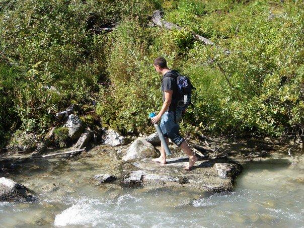
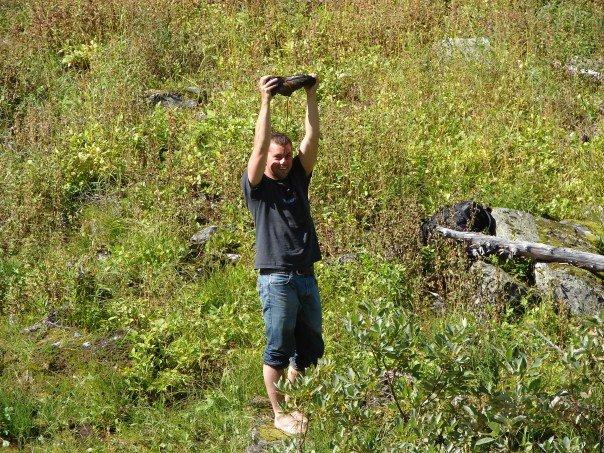
7 Team Avalanche, Missing Boot Brook and our Avalanche shoot
8

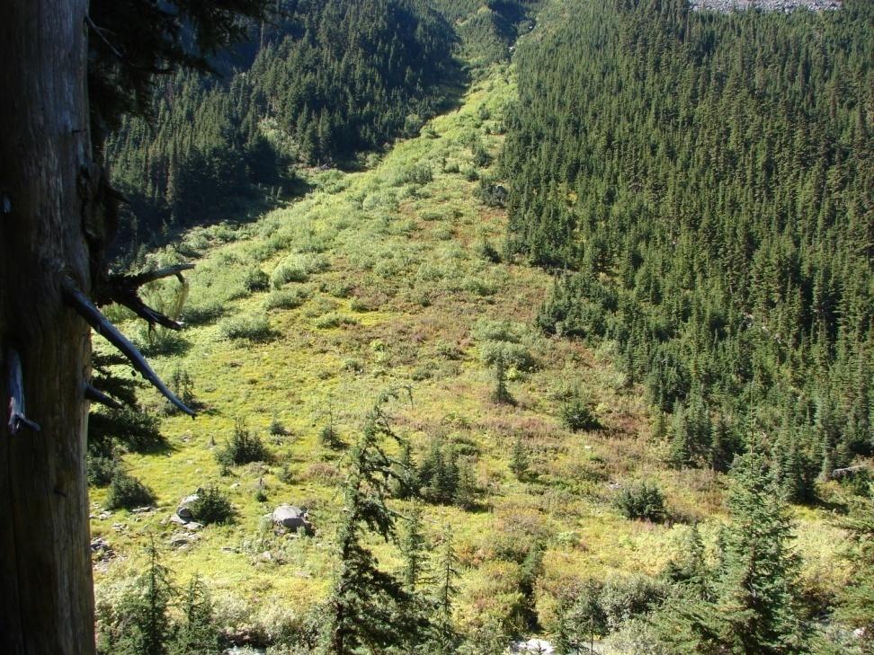
9 East and West viewpoints

10 Subalpine fir age range yrs Western Western Mountain Hemlock age range yrs Englemann Spruce age range yrs Tree species


11 Tree coring Base cores taken from the ground Scars

12 Scars
13 Methodology Took base core samples and scar samples. Scars were taken wherever they could be found at various elevations. A transect was set up on the northern side to produce age profile. Took tape measurements of estimated transect avalanche and distance traveled up slope, slope measurements. Sanded samples using six different grades (50, 80, 120, 220, 400 and 600). Scanned and analyzed samples with WinDendro 05/06 and Microscope.
14
15
16 Close relation between curves - Tree age useful as avalanche indicator.
17 Change in tree age with distance towards the interior of the Avalanche shoot. Decrease in age with the exception.
18 Assume Assume avalanches are controlling factor on tree age Scar Scar and tree age data to determine the minimum number of avalanches over a period ( date of oldest found event). Frequency and magnitude - number of events and extent of avalanche
19 Avalanches that reach the lateral extent of the shoot occur less frequently The The exception in the age prolie is a bit of a puzzle - maybe indication of different avalanche paths Additional research required
20 25 events with magnitude sufficient to reach Asulkan trail - about every 4 years 3 3 events with magnitude sufficient to climb about 100 m up the opposite slope - about every 37 years 1 1 event with magnitude sufficient to climb 150m or more up opposite slope - about every 73 years
21 Risk is subjective

22 Asulkan Risks
23 Park usage From From traffic increased 1% to 2% annually Ski tourism increasingly popular By 2001 Asulkan trail head exceeds capacity Asulkan Asulkan classified as a High Use Backcounty Land Management Unit
24 Trail Usage winter season
25 Monthly usage
26 Conclusions Evidence Evidence that high magnitude avalanches do cross the trail frequently There There is a risk to cross country skiers Further Further research is needed
27 What we would do differently More cores from both sides. Difficulty in identifying trees and types of scars (fire/bear/avalanche). Coring issues, and finding scars. Problems with project: absence of trees does not mean it is because of avalanche- heavy snow pack. Judgment call in approximate length of max. avalanche track. Put shoe in bag to cross river
28 References imap BC Avalanche Terrain Ratings for the Mountain National Parks, Parks Canada Parks Canada trail count data courtesy of Anna Brown, Park Warden Parks Canada, Mount Revelstoke National Park of Canada and Glacier National Park of Canada and Rogers Pass National Historic Site of Canada Management Plan, g/bc/glacier/pd-mp/toc-tdm_e.asptdm_e.asp
ENVIRONMENTAL HAZARDS OF AVALANCHES: PRELIMINARY RESEARCH IN GLACIER NATIONAL PARK
 ENVIRONMENTAL HAZARDS OF AVALANCHES: PRELIMINARY RESEARCH IN GLACIER NATIONAL PARK Site Focus: Balu Pass, Glacier National Park, B.C. Avalanche path near Balu Pass. (Photo Courtesy of: www.leelau.net/2007/rogerspass/day1/1)
Dating the Asulkan s East Spill Over Zone. Cali Bingham, Kara Piman, Blair Underhill, Martin Demidow, Sam Ward, Derek Heathfield and Ahmed Mumeni
 Dating the Asulkan s East Spill Over Zone Cali Bingham, Kara Piman, Blair Underhill, Martin Demidow, Sam Ward, Derek Heathfield and Ahmed Mumeni Purpose and Objectives Establish approximate dates of terminal
TUPPER DESIGNATED ACCESS ROUTE
 TUPPER DESIGNATED ACCESS ROUTE 1 FOR ACCESS/EGRESS TO CONNAUGHT, LOOKOUT, STONE ARCH, PORTAL PATHS AND TUPPER TRAVERSE EGRESS Length: 2.6km Vertical Gain: +162m / -83m (Values are for access. For egress,
Dating the Cheops Glacier with Lichenometry, Dendrochronology and Air Photo Analyses
 Dating the Cheops Glacier with Lichenometry, Dendrochronology and Air Photo Analyses By: Janek Wosnewski, Sean Hillis, Dan Gregory and Kodie Dewar December 09, 2009 Geography 477 Field School Instructor:
The Use of Dendrochronology to Determine Avalanche Frequency Along the Avalanche Path East of Balu Peak, Within the Balu Pass Trail, Roger's Pass, BC.
 1 The Use of Dendrochronology to Determine Avalanche Frequency Along the Avalanche Path East of Balu Peak, Within the Balu Pass Trail, Roger's Pass, BC. Allison Dick, Donald Mcfarlane, and Robyn McGregor
MP : the top of the bottom switchback
 MP 237 238: the top of the bottom switchback For reference this section of U S Highway 40 has been called the top of the bottom switchback on the Grand County side of the Pass. It is here that the proposed
Excelsior Pass Avalanche Accident January 1, 2008
 Excelsior Pass Avalanche Accident January 1, 2008 Accident Summary Time: 1 January 2008, approximately 13:00 hrs Location: Near Excelsior Pass to east of Church Mt, Northern Washington Cascades WA Activity:
VISITOR RISK MANAGEMENT APPLIED TO AVALANCHES IN NEW ZEALAND
 VISITOR RISK MANAGEMENT APPLIED TO AVALANCHES IN NEW ZEALAND Don Bogie*, Department of Conservation, Christchurch, New Zealand Mike Davies, Department of Conservation, Wellington, New Zealand ABSTRACT:
Jumbo Glacier Resort Master Plan Appendix 2-A
 Jumbo Glacier Resort Master Plan Appendix 2-A Avalanche Studies and Reports prepared by P. Schaerer of Stetham & Associates Pheidias Project Management Corp. Copyright June, 2005 JUMBO
Winter Terrain Atlas. Mount Revelstoke and Glacier National Parks
 Winter Terrain Atlas Mount Revelstoke and Glacier National Parks Winter Terrain Atlas - Table of Contents Glacier East Slide Paths Hermit Macdonald and Avalanche Connaught Creek Drainage Ursus Creek Drainage
Example of the layout of a Fieldwork Atlas
 Example of the layout of a Fieldwork Atlas Example of a Worksite with multiple facilities and work goals in one area: Map Center 49 3 46 N 117 3 11 W Noname Area with typical travel route marked. Avalanche
Guide Training Ski TAP APPLICATION PACKAGE. Hello and thank you for your interest in applying to the ACMG Training and Assessment Program (TAP).
.") Hello and thank you for your interest in applying to the ACMG Training and Assessment Program (TAP). As of April 30, 2018, the ACMG will be running the program for an undetermined period. For any courses
Hello and thank you for your interest in applying to the ACMG Training and Assessment Program (TAP). As of April 30, 2018, the ACMG will be running the program for an undetermined period. For any courses
26 Utah s Patchwork Parkway SCENIC BYWAY CORRIDOR MANAGEMENT PLAN (SR 143)
") Natural Natural Quality applies to those features in the visual environment that are in a relatively undisturbed state. These features predate the arrival of human populations and may include geological
Natural Natural Quality applies to those features in the visual environment that are in a relatively undisturbed state. These features predate the arrival of human populations and may include geological
Ski / Sled tracks as an expression of avalanche risk Jordy Hendrikx 1 & Jerry Johnson 2,1 1.
 Ski / Sled tracks as an expression of avalanche risk Jordy Hendrikx 1 & Jerry Johnson 2,1 1 Snow and Avalanche Laboratory, Montana State University, Bozeman, Montana, USA 2 Political Science, Montana State
Exemplar for Internal Achievement Standard Geography Level 1. Conduct geographic research, with direction
 Exemplar for internal assessment resource Geography for Achievement Standard 91011 Exemplar for Internal Achievement Standard Geography Level 1 This exemplar supports assessment against: Achievement Standard
Opportunities for Snowmobile Avalanche Education: An Exploration of the Current State of Snowmobiling in the Backcountry
 Opportunities for Snowmobile Avalanche Education: An Exploration of the Current State of Snowmobiling in the Backcountry Proposal of Final Project by Miranda Murphy Master of Arts - Integrated Studies
Restore and implement protected status that is equivalent, or better than what was lost during the mid-1990 s
 THE ROSSLAND RANGE, OLD GLORY AREA. Executive summary. The Friends of the Rossland Range Society, on behalf of the local outdoor community, seeks to accomplish the following with respect to the Old Glory
2010 International Snow Science Workshop
 MAPPING EXPOSURE TO AVALANCHE TERRAIN Cam Campbell* and Peter Marshall Canadian Avalanche Centre, Revelstoke, British Columbia ABSTRACT: During the winter of 2009-10, several signs were created in collaboration
Visitor Profile - Central Island Region
 TOURISM LABOUR MARKET RESEARCH PROJECT 2003 The Project The Tourism Labour Market Research Project, was designed to study the tourism labour market throughout the Vancouver Island region. The Visitor Survey
Glacier National Park
 Glacier National Park West Glacier, MO Page 1 Page 3-6 Report Rough Draft Glacier National Park Glacier National Park is located in the northwest corner of Montana and extends into Canada. It is located
Mapping the Snout. Subjects. Skills. Materials
 Subjects Mapping the Snout science math physical education Skills measuring cooperative action inferring map reading data interpretation questioning Materials - rulers - Mapping the Snout outline map and
Avalanche Prevention
 Avalanche Prevention COUGAR CORNER, CA COUGAR CORNER Avalanche Prevention Project Place Country/Region Cougar Corner Rogers Pass Area Canada Year of installation 2016 Customer Engineering Contractor Parks
PREPARE TO STOP DIP ROUGH ROAD SPEED ZONE AHEAD DANGER STOP AT PULLOFF ONLY 30 MUXIMUM SLOW TRAFFIC KEEP RIGHT. FOrm SINGLE LINE.
 SPEED ZONE AHEAD PREPARE TO STOP DANGER STOP AT PULLOFF ONLY 30 SLOW TRAFFIC KEEP RIGHT Maple Leaf FOrm SINGLE LINE DIP ROUGH ROAD MUXIMUM 30 (1101) éé 7/1 7/2 7/3 7/4 7/5 7/6 7/7~8 7/9 7/10 Monashe Mountain
VAST Challenge 2017 Reviewer Guide: Mini-Challenge 1
 VAST Challenge 2017 Reviewer Guide: Mini-Challenge 1 This document provides information to support peer review of submissions to VAST Challenge 2017, Mini-Challenge 1. It covers background about the submission
Visitor risk management in core zones of protected areas: First results from a survey of European park administrations
 Visitor risk management in core zones of protected areas: First results from a survey of European park administrations Zahra Ghelichipour, Andreas Muhar Abstract - Effective visitor risk management practices
Note: Coordinates are provided as Universal Transverse Mercator UTM Zone U21, North American Datum 1983 (NAD 83).
.") Northern Traverse Route Description The Northern Traverse (formerly the North Rim Traverse) is an unmarked and rugged backcountry hiking route. It is known be a demanding hike, because of its terrain and
Northern Traverse Route Description The Northern Traverse (formerly the North Rim Traverse) is an unmarked and rugged backcountry hiking route. It is known be a demanding hike, because of its terrain and
RE: Extreme Avalanche Hazard at New Jumbo Glacier Resort (JGR) Daylodge Building Site
 Daylodge Building Site") To: Ms. Autumn Cousins Manager, Policy and Compliance BC Environmental Assessment Office, via Email to autumn.cousins@gov.bc.ca and eao.compliance@gov.bc.ca PO Box 9426 Stn Prov Govt Victoria, BC V8W 9V1
To: Ms. Autumn Cousins Manager, Policy and Compliance BC Environmental Assessment Office, via Email to autumn.cousins@gov.bc.ca and eao.compliance@gov.bc.ca PO Box 9426 Stn Prov Govt Victoria, BC V8W 9V1
FRANCE : HOW TO IMPROVE THE AVALANCHE KNOWLEDGE OF MOUNTAIN GUIDES? THE ANSWER OF THE FRENCH MOUNTAIN GUIDES ASSOCIATION. Alain Duclos 1 TRANSMONTAGNE
 FRANCE : HOW TO IMPROVE THE AVALANCHE KNOWLEDGE OF MOUNTAIN GUIDES? THE ANSWER OF THE FRENCH MOUNTAIN GUIDES ASSOCIATION ABSTRACT : Alain Duclos 1 TRANSMONTAGNE Claude Rey 2 SNGM The French Mountain Guides
Risk Assessment in Winter Backcountry Travel
 Wilderness and Environmental Medicine, 20, 269 274 (2009) ORIGINAL RESEARCH Risk Assessment in Winter Backcountry Travel Natalie A. Silverton, MD; Scott E. McIntosh, MD; Han S. Kim, PhD, MSPH From the
THE YIELD OF AVALANCHE SNOW AT ROGERS PASS, BRITISH COLUMBIA, CANADA
 Journal / Glaciology, Vol. 34, No. 117, 1988 THE YIELD OF AVALANCHE SNOW AT ROGERS PASS, BRITISH COLUMBIA, CANADA By PETER SCHAERER (Institute for Research in Construction, National Research Council of
Estimating Tourism Expenditures for the Burlington Waterfront Path and the Island Line Trail
 A report by the University of Vermont Transportation Research Center Estimating Tourism Expenditures for the Burlington Waterfront Path and the Island Line Trail Report # 10-003 February 2010 Estimating
RTM 151C Winter Mountaineering (2 units) Department of Recreation and Tourism Management California State University Northridge
 Department of Recreation and Tourism Management California State University Northridge") RTM 151C Winter Mountaineering (2 units) Department of Recreation and Tourism Management California State University Northridge Spring 2017 Redwood Hall 151 Sat. 9:00-10:40 Class Meetings on Jan 21 plus
RTM 151C Winter Mountaineering (2 units) Department of Recreation and Tourism Management California State University Northridge Spring 2017 Redwood Hall 151 Sat. 9:00-10:40 Class Meetings on Jan 21 plus
Authentic Assessment in Algebra NCCTM Undersea Treasure. Jeffrey Williams. Wake Forest University.
 Undersea Treasure Jeffrey Williams Wake Forest University Willjd9@wfu.edu INTRODUCTION: Everyone wants to find a treasure in their life, especially when it deals with money. Many movies come out each year
2009 Muskoka Airport Economic Impact Study
 2009 Muskoka Airport Economic Impact Study November 4, 2009 Prepared by The District of Muskoka Planning and Economic Development Department BACKGROUND The Muskoka Airport is situated at the north end
Twin Lakes Avalanche Incident 1/31/2016
 Twin Lakes Avalanche Incident 1/31/2016 Location: Place State Published by: Dave Bingaman (PAC), George Halcom (PAC), and Kent May (PAC) Twin Lakes, Salmon River Mountains Idaho Date 01/31/2016 Time Summary
THE IMPACTS OF CLIMATE CHANGE ON SKI RESORTS AND TOURIST TRAFFIC. M. Tepfenhart, W. Mauser and F. Siebel
 THE IMPACTS OF CLIMATE CHANGE ON SKI RESORTS AND TOURIST TRAFFIC M. Tepfenhart, W. Mauser and F. Siebel Department of Geography, University of Munich, Luisenstr. 37, D - 80333 Munich, Germany, Sebastian
Resort Municipality Initiative Annual Report 2015
 Resort Municipality Initiative Annual Report 2015 Submitted by: City of Rossland in association with Tourism Rossland Prepared by: Deanne Steven Acknowledgements The City of Rossland would like to thank
General information for passengers
 Mountaineering General information for passengers Mountaineering is a special activity option on selected voyages in Antarctica on board m/v Plancius and m/v Ortelius ( Basecamp ) marked M on the tour
Victor Lake Park. Management Plan
 Victor Lake Park Management Plan November 2012 Victor Lake Park Management Plan Approved by: Jeff Leahy, Regional Director Thompson Cariboo Region BC Parks March 28, 2012 Date Brian Bawtinheimer, Executive
Cambridge International Examinations Cambridge International General Certificate of Secondary Education
 Cambridge International Examinations Cambridge International General Certificate of Secondary Education *3565143540* GEOGRAPHY 0460/42 Paper 4 Alternative to Coursework May/June 2017 1 hour 30 minutes
NOTE TO INQUIRY BACKGROUND CRASH RATE DEFINITIONS. TRUDY AUTY, BSc, ARCS FOR LAAG
 TOWN AND COUNTRY PLANNING ACT 1990 - SECTION 77 AND TOWN AND COUNTRY PLANNING (INQUIRIES PROCEDURE) (ENGLAND) RULES 2000 APPLICATIONS BY LONDON ASHFORD AIRPORT LTD SITE AT LONDON ASHFORD AIRPORT LIMITED,
Appendix A BC Provincial Parks System Goals
 Appendix A BC Provincial Parks System Goals The British Columbia Provincial Parks System has two mandates: To conserve significant and representative natural and cultural resources To provide a wide variety
Northern Ontario Passenger Vehicle Travel Profile
 TRANSPORTATION Final Report The Preparation of a Northern Ontario Passenger and Commercial Vehicle Origin-Destination Survey Northern Ontario Passenger Vehicle Travel Profile Submitted to Ministry of Transportation,
Summer 2013 Dalton Highway Recreation Study
 Summer 2013 Dalton Highway Recreation Study Implications for Recreation and Visitor Services Planning Peter J Fix School of Natural Resources and Extension University of Alaska Fairbanks OLLI Session 2
Yard Creek Provincial Park. Management Plan
 Yard Creek Provincial Park Management Plan Draft January 2010 Yard Creek Provincial Park Management Plan Approved by: telàlsemkin/siyam/chief Scott Benton Bill Williams Squamish Executive Director ation
THRESHOLD GUIDELINES FOR AVALANCHE SAFETY MEASURES
 BRITISH COLUMBIA MINISTRY OF TRANSPORTATION & INFRASTRUCTURE AVALANCHE & WEATHER PROGRAMS THRESHOLD GUIDELINES FOR AVALANCHE SAFETY MEASURES British Columbia Ministry of Transportation & Infrastructure
TROOP FIVE BOY SCOUTS OF AMERICA (
 TROOP FIVE BOY SCOUTS OF AMERICA (http://www.troop5.net) HISTORIC MOUNT WASHINGTON HIKE LOCATION: White Mountain National Forest, New Hampshire DATE: Friday - Monday, June 25-28 th, 2010. TIME: Be at the
50 YEARS OF AVALANCHE DEATHS IN THE UNITED STATES. Dale Atkins * Colorado Avalanche Information Center. Knox Williams
 50 YEARS OF AVALANCHE DEATHS N THE UNTED STATES Dale Atkins * Colorado Avalanche nformation Center Knox Williams Colorado Avalanche nformation Center ABSTRACT: Since 1950593 people have died in avalanches.
Mountain Goats and Winter Recreation November 17, 2011
 Mountain Goats and Winter Recreation November 17, 2011 Summary Mountain goats need protection from disruption and displacement in their winter feeding areas by motorized and non-motorized recreationists
Mindful Mountain Hiking Program
 Mindful Mountain Hiking Program Want to head for the hills? Join the Mindful Mountain Hiking Program for the summer and early autumn. Day hikes in Kananaskis Country and the Rockies are led by ACMG Day
TREK INTO MAURIENNE in 6 days
 TREK INTO MAURIENNE in 6 days A not very committed glacial trek with accessible difficulties. A real wild route with a good welcome of the wardens of refuges. A particularly snow-covered beautiful area
Gravel and Rock Extraction Highway Maintenance, Recapitalization and Twinning
 Gravel and Rock Extraction Highway Maintenance, Recapitalization and Twinning Backgrounder: Mountain National Parks A Need for Change Existing supplies of aggregate (sand and gravel) for highway maintenance,
L ANDS ADJACENT TO BANFF TRAILS STUDY
 L ANDS ADJACENT TO BANFF TRAILS STUDY Copies of this report may be obtained from: Banff National Park Park Planner Parks Canada Banff National Park P.O. Box 900 Banff, AB, T1L 1K2 A copy of this report
United States Department of the Interior National Park Service. Boundary Expansion Listed in National Register January 11, 2017
 NPS Form 10900-a (Rev. 8/2002) OMB No. 10240018 United States Department of the Interior National Park Service Boundary Expansion Listed in National Register January 11, 2017 National Register of Historic
IMPLICATIONS FOR TOURISM AND RECREATION
 IMPLICATIONS FOR TOURISM AND RECREATION Table of Contents Background... 1 Research methods... 5 CLIMATE CHANGE IMPACTS National park visitation... 9 Seasonal recreation Ski industry... 11 Golf industry...
Digital Terrain Analysis of Archer Mountain
 Digital Terrain Analysis of Archer Mountain Identifying a potential new recreational trail Photo: Justin Bush GEOG 593 - Duh Marcus Tobey Justin Bush Project Overview Background Project Area Overview Questions
GIFFORD PINCHOT NATIONAL FOREST
 GIFFORD PINCHOT NATIONAL FOREST 9341 Wright Meadow 93 Spencer Meadow Spencer Butte 4247' 30 30A 19 24 80 31C Lewis River Lower Falls 5 Quartz Creek 90 Taidnapam Falls Upper Falls 31 Spencer Peak 3861'
RW Bruhn Bridge and Approaches Project
 RW Bruhn Bridge and Approaches Project The Trans-Canada Highway 1 RW Bruhn Bridge and Approaches Project involves four-laning approximately 1.9 km of Highway 1 in Sicamous, including replacement of the
Engagement Summary Report. Trans-Canada Highway 1 RW Bruhn Bridge Replacement Project. Community Engagement November 15, 2016 to January 15, 2017
 Trans-Canada Highway 1 RW Bruhn Bridge Replacement Project Community Engagement November 15, 2016 to January 15, 2017 Engagement Summary Report February 2017 Prepared by Kirk & Co. Consulting Ltd. Trans-Canada
Western Highways Transportation Corridor: Adaptation and Challenges for Preserving a Cultural Landscape Today
 16 Western Highways Transportation Corridor: Adaptation and Challenges for Preserving a Cultural Landscape Today Gwénaëlle Le Parlouër, Cultural Resource Management Advisor, Parks Canada Agency, 30 Victoria
SNOW-SHOEING. $485 for one or two people 10:00 am to 3:00 pm, includes packed lunch ($240 for each additional person, Gratuity Included)
") SNOW-SHOEING There is no better way to experience the serene winter beauty of the San Juan Mountains than with a pair of snowshoes strapped to your feet. Frolic in fresh Colorado powder while learning
SNOW-SHOEING There is no better way to experience the serene winter beauty of the San Juan Mountains than with a pair of snowshoes strapped to your feet. Frolic in fresh Colorado powder while learning
Applying for Tourism Signs
 Applying for Tourism Signs Section 1, Application for Tourism Signing in Kent Introduction Kent County Council Highways and Transportation (KCC Highways) control signs on local roads (excluding Medway)
Mt. Gunnbjörn, Dome and Cone (IMG66)
") 2018 The Peaks of Greenland: Mt. Gunnbjörn, Dome and Cone (IMG66) Ski ascent of the highest peaks in the Greenland Arctic - Expedition manual - Content overview Expedition overview Further information
2018 The Peaks of Greenland: Mt. Gunnbjörn, Dome and Cone (IMG66) Ski ascent of the highest peaks in the Greenland Arctic - Expedition manual - Content overview Expedition overview Further information
National Recreation Trail Update Form
 National Recreation Trail Update Form Introduction Thank you for taking the time to complete this form. Your assistance will help ensure that the National Recreation Trail (NRT) database is complete and
THE WHOLE DÔMES DE MIAGE VIA DURIER IN 2 DAYS 3,673 M
 THE WHOLE DÔMES DE MIAGE VIA DURIER IN 2 DAYS 3,673 M The most beautiful snow ridge of Tré la Tête basin, a mythical crossing in one of the wildest areas of Mont-Blanc massif! The private kingdom of our
Glacier Retreat/ Developement in Glacier National Park
 Geog 413 Term Project Glacier Retreat/ Developement in Glacier National Park Heather Miller December 01, 2004 Abstracts Introduction / background Data Source Data Manipulation Spatial analysis method/process
Skiing and Snowshoes on Un-groomed Fernan Saddle Terrain
 Skiing and Snowshoes on Un-groomed Fernan Saddle Terrain Three ski or snowshoe routes are available from the Fernan Saddle Parking Lot which either do not cover routes ordinarily groomed for snow machine
MP : Headwaters of the Fraser River
 MP 236 237: Headwaters of the Fraser River The mile between these two mileage posts is often just referred to as the bottom switchback or the curve at the bottom of Berthoud Pass. For many locals this
Snow Way by Beth Geiger
 6 th Grade ELA SAMPLES OF STANDARDS STUDENTS ARE LEARNING THIS NINE WEEKS: STANDARDS: RI.6.2, RI.6.3, RI.6.5, RI.6.8, W.6.2 Snow Way by Beth Geiger Where will you find the world s best spot for stargazing?
Pocahontas Area Map Jasper INFORMATION CENTRES Lake Louise Field Golden Banff
 Pocahontas Miette Hot Springs Area Map Jasper Maligne JASPER Columbia Icefield Saskatchewan River Crossing INFORMATION CENTRES Banff National Park Louise Kootenay Park Lodge Yoho National Park Columbia
Domestic Tourism Statistics in India
 Domestic Tourism Statistics in India S V Ramana Murthy Deputy Director General Ministry of Statistics & Programme Implementation Email: svr.murthy@nic.in Presentation Sources of data Concerns Need for
Prior to contacting the Whitecourt Trailblazers Snowmobile Club, applicants must:
 WHITECOURT TRAILBLAZERS Box 607 Whitecourt, AB T7S 1N7 www.whitecourttrailblazers.ca CNT AMENDMENT Restriction Code 710: See Comments Comments All applicants are required to contact: Whitecourt Trailblazers
Meadows in the Sky Area Plan. Mount Revelstoke National Park. for discussion
 Meadows in the Sky Area Plan Mount Revelstoke National Park for discussion Meadows in the Sky Area Plan - Introduction Mount Revelstoke National Park celebrates its 100 th anniversary in 2014. Parks Canada
Recreational Services Plan. Gatineau Park. Phase 1: Planning Framework
 Recreational Services Plan Gatineau Park Phase 1: Planning Framework 1 Plan Planning in Gatineau Park Gatineau Park : an overview Trends Preliminary assessment Strategic framework 2 Unique natural and
Role of the Protected Area
 Role of the Protected Area Provincial and Regional Context Height of the Rockies and Elk Lakes provincial parks lie in southeastern British Columbia in the Rocky Mountains, about 85 km southwest of Calgary,
Route #2) Mt. Massive - Southwest Slopes
 Mt. Massive - Southwest Slopes") Route #2) Mt. Massive - Southwest Slopes Difficulty: Class 2 Ski: Advanced, D6 / R2 / III Exposure: Summit Elevation: Trailhead Elevation: Elevation Gain: Round-trip Length: Trailhead: County Sheriff:
Route #2) Mt. Massive - Southwest Slopes Difficulty: Class 2 Ski: Advanced, D6 / R2 / III Exposure: Summit Elevation: Trailhead Elevation: Elevation Gain: Round-trip Length: Trailhead: County Sheriff:
REGIONAL WILDLIFE CORRIDOR STUDY. Wind Valley/Dead Mans Flats
 REGIONAL WILDLIFE CORRIDOR STUDY Wind Valley/Dead Mans Flats Part II Wildlife Corridor Delineation Prepared for The Wind Valley Wildlife Corridor Committee that includes: Regulatory Agencies Alberta Sustainable
Engagement Summary Report. Trans-Canada Highway 1 RW Bruhn Bridge and Approaches Project Community Engagement February 1 18, 2018.
 Trans-Canada Highway 1 RW Bruhn Bridge and Approaches Project Community Engagement February 1 18, 2018 Engagement Summary Report April 2018 Prepared by Kirk & Co. Consulting Ltd. Trans-Canada Highway 1
TRACKING HELI-SKI GUIDES TO UNDERSTAND DECISION MAKING IN AVALANCHE TERRAIN
 TRACKING HELI-SKI GUIDES TO UNDERSTAND DECISION MAKING IN AVALANCHE TERRAIN Jordy Hendrikx 1*, Christopher Shelly 2 and Jerry Johnson 3, 1 1 Snow and Avalanche Laboratory, Department of Earth Sciences,
In southern Upper Valais a very high avalanche danger will be encountered in some regions Edition: , 08:00 / Next update: 9.1.
 Page 1/6 In southern Upper Valais a very high avalanche danger will be encountered in some regions Edition: 9.1.2018, 08:00 / Next update: 9.1.2018, 17:00 Avalanche danger updated on 9.1.2018, 08:00 region
5 Rail demand in Western Sydney
 5 Rail demand in Western Sydney About this chapter To better understand where new or enhanced rail services are needed, this chapter presents an overview of the existing and future demand on the rail network
APPENDIX X: RUNWAY LENGTH ANALYSIS
 APPENDIX X: RUNWAY LENGTH ANALYSIS Purpose For this Airport Master Plan study, the FAA has requested a runway length analysis to be completed to current FAA AC 150/5325-4B, Runway Length Requirements for
National Recreation Trail Application for Designation
 National Recreation Trail Application for Designation Introduction Thank you for your interest in the National Recreation Trail (NRT) program. Completed NRT application packages must be submitted by December
Non-motorized Trail Plan & Proposal. August 8, 2014
 Town of Star Valley Ranch, Wyoming and the Star Valley Ranch Association in partnership with the USDA Forest Service, Bridger-Teton National Forest, Greys River Ranger District Non-motorized Trail Plan
Alpine Glacial Features along the Chimney Pond Trail, Baxter State Park, Maine
 Maine Geologic Facts and Localities September, 2009 Alpine Glacial Features along the Chimney Pond Trail, Baxter State Park, Maine 45 54 57.98 N, 68 54 41.48 W Text by Robert A. Johnston, Department of
(west) onto Charleston Boulevard. Drive 16 miles on Charleston and turn right into Red Rock
 onto Charleston Boulevard. Drive 16 miles on Charleston and turn right into Red Rock") Hike: North Peak and Ice Box Overlook up and back Trailhead: 2.5 miles up the Rocky Gap Road not mark Distance: 5 miles round trip Elevation gain: 2,694 feet Elevation Peak: 7,094 feet Time: 3 to 5 hours
Hike: North Peak and Ice Box Overlook up and back Trailhead: 2.5 miles up the Rocky Gap Road not mark Distance: 5 miles round trip Elevation gain: 2,694 feet Elevation Peak: 7,094 feet Time: 3 to 5 hours
Mt. Gunnbjörn, Dome and Cone (IMG66)
") 2015 The Peaks of Greenland: Mt. Gunnbjörn, Dome and Cone (IMG66) Ski ascent of the highest peaks in the Greenland Arctic - Expedition manual - Content overview Expedition overview Further information
2015 The Peaks of Greenland: Mt. Gunnbjörn, Dome and Cone (IMG66) Ski ascent of the highest peaks in the Greenland Arctic - Expedition manual - Content overview Expedition overview Further information
P.O. Box 65 Hancock, Michigan USA fax
 This PDF file is a digital version of a chapter in the 2005 GWS Conference Proceedings. Please cite as follows: Harmon, David, ed. 2006. People, Places, and Parks: Proceedings of the 2005 George Wright
AURORA WILDLIFE RESEARCH
 AURORA WILDLIFE RESEARCH Kim Poole 2305 Annable Rd. Nelson, BC, V1L 6K4 Canada Tel: (250) 825-4063; Fax: (250) 825-4073 e-mail: klpoole@shaw.ca 27 April 2005 Mike Gall Conservation Specialist and Glenn
Fee: $ USD /person (see below)
") Information Package Package Includes: Team and Individual participation fees in the WSI Events (6 game guarantee) 1 Practice, 1 Exhibition Game / Scrimmages & 1 Multinational Game prior to tournaments
Information Package Package Includes: Team and Individual participation fees in the WSI Events (6 game guarantee) 1 Practice, 1 Exhibition Game / Scrimmages & 1 Multinational Game prior to tournaments
2012 Mat Su Valley Collision Avoidance Survey
 Table of Contents Table of Contents 1 INTRODUCTION Measurement Objectives 3 Methodology and Notes 4 Key Findings 5 PILOT LOCATION Activity in the Area 7 Pilot Location 8 Altitudes Flown 9 SAFETY IN THE
ENVIRONMENTAL PROFILE:
 Pyrenees Study Area for LEDDRA LOCATION: The Pyrenees study area is located in the Spanish Central Pyrenees (42º 36 N, 0º 00 E), in the Sobrarbe area (Huesca province, Aragón region). It includes the municipalities
TELEMARK NORDIC 5 YEAR PLAN OCTOBER, 2014
 Page 1 of 6 TELEMARK NORDIC 5 YEAR PLAN OCTOBER, 2014 VISION At Telemark all individuals will be able to follow their passion of cross country skiing, biathlon and snowshoeing in a first class, stimulating
blanketglacierchalet.com
 START: 0645 HRS (PST) Swiss Chalet, downtown Revelstoke END: Early morning at Blanket Glacier Heli Staging South of Revelstoke BASE MANAGER: Al and Marion Schaffer, OR Jami Kruger (Heli Coordinator) Our
Adventure & Sightseeing Tours
 Adventure & Sightseeing Tours The National Parks Circle Tour Start & Finish: Vancouver Duration: 14-21 Distance: 2500 km Drive the TransCanada Highway and you will pass through one National Park after
Mountain Footsteps. Photo: Ric Carless
 ho: Ric Carless Road Directions Middle White River FS Roads Deep Lake and Driftwood Lake see page 101, Connor Lakes along Maiyuk Creek see page 105, and for access Top of the World rovincial ark see page
1999 Reservations Northwest Users Survey Methodology and Results November 1999
 1999 Reservations Northwest Users Survey Methodology and Results November 1999 Oregon Survey Research Laboratory University of Oregon Eugene OR 97403-5245 541-346-0822 Fax: 541-346-5026 Internet: OSRL@OREGON.UOREGON.EDU
2004 SOUTH DAKOTA MOTEL AND CAMPGROUND OCCUPANCY REPORT and INTERNATIONAL VISITOR SURVEY
 2004 SOUTH DAKOTA MOTEL AND CAMPGROUND OCCUPANCY REPORT and INTERNATIONAL VISITOR SURVEY Prepared By: Center for Tourism Research Black Hills State University Spearfish, South Dakota Commissioned by: South
Runway Roughness Evaluation- Boeing Bump Methodology
 FLIGHT SERVICES Runway Roughness Evaluation- Boeing Bump Methodology Michael Roginski, PE, Principal Engineer Boeing Airport Compatibility Engineering ALACPA X Seminar, Mexico City, Mexico September 30-
August 22, Carol Prentice
 Sacajawea s Bitterroot Field Summary Report MOSQUITO CONSOLIDATED GOLD MINES, LTD. CUMO MINERALS EXPLORATION PROJECT IDAHO CITY RANGER DISTRICT, BOISE NATIONAL FOREST August 22, 2011 Carol Prentice This