PROLINE-CE. D.C.3.8 Croatian pilot actions EXCURSION BROCHURE. Imotsko polje and South Dalmatia springs
|
|
|
- Rose Robbins
- 5 years ago
- Views:
Transcription


1 D.C.3.8 Croatian pilot actions PROLINE-CE Imotsko polje and South Dalmatia springs EXCURSION BROCHURE

2 EXCURSION BROCHURE D.C.3.8 Pilot actions Imotsko polje and South Dalmatia springs CROATIAN GEOLOGICAL SURVEY Milana Sachsa Zagreb Department of Hydrogeology and Engineering Geology CONTRIBUTORS Josip Terzić, PhD Jasmina Lukač Reberski, PhD Ivana Boljat, dipl.ing.geol. Ivona Baniček, mag.geol. Matko Patekar, mag.geol. Editor Ana Selak, mag.ing.geol. mag.ing.prosp.arch. Issued April, 2018


3 Imotsko polje and Reservoir Ričice Imotski lakes: Crveno lake and Modro lake Prud spring Baćina lakes
4 EXCURSION BROCHURE 1 IMOTSKO POLJE and RESERVOIR RIČICE D.C.3.8 Pilot actions Imotsko polje and South Dalmatia springs Imotsko-Bekijsko polje, typical karstic field characterized by very complex hydrogeological features, stretches parallel to Dinaric direction (NW-SE) on area of 92 km 2. Imotsko polje is partly located within the territory of Republic of Croatia, while the remainder is in the neighbouring Federation of Bosnia and Herzegovina. The largest settlement in this area is Imotski with inhabitants. Several springs (Opačac being the largest one) form the eight name river, locally called Vrljika, the largest watercourse and recipient in Imotsko polje which drains the water through ponor (swallow-hole) on the southeastern part of polje and through Pećnik tunnel towards Federation of Bosnia and Herzegovina (reoccurring in the spring area of Tihaljina and through groundwater connections in Vrgoračko polje). Imotsko-Bekijsko polje is largely built of limestones and dolomites of Cretaceous age ( Ma), characterized by fracture-cavernous porosity. The oldest deposits that form the catchment are of Lower Cretaceous age (Rajić et al., 1977). The surrounding mountains and other elevations as well as karstic plateaus are all built from well permeable limestone, while the valleys are made in the less resilient limestone-dolomitic and dolomitic rocks or in the younger, Tertiary semi-permeable and impermeable deposits. Tertiary deposits ( Ma*), mostly consisting of flysch, lie transgressively on the Cretaceous base, while the Quaternary ones ( Ma) are deposited in Imotsko polje. These consist mostly of alluvial deposits of sand, gravel, loam, mixed with terra rossa and humus, and in the central part of the polje Pleistocene deposits ( Ma) are located clay, gravel and sand. 1 As a typical karst field, Imotsko polje has numerous springs (NE part) which form complex hydrological network in asymmetrical catchment. Besides Vrljika, other notable streams are Ričina and Suvaja (which forms Prološko Blato protected wetland area, periodically exposed to floods). *Ma = million years ago
5 As a typical karst field, Imotsko polje has numerous springs (NE part) which form complex hydrological network in an asymmetrical catchment. Besides Vrljika, other notable streams are Ričina and Suvaja (which forms Prološko Blato protected wetland area, periodically exposed to floods). The deposits in one part of the Imotsko polje represent a topographical barrier, while the major part of the polje has the function of an overhanging barrier. Quaternary deposits of the field, up to 150 m thick, of a clay-sandy composition in the part of the field around Opačac spring, have the function of a complete barrier and cause the drainage of the groundwaters that gravitate towards the field from the carbonate hinterland in the north and northeast. The most complicated hydraulic relationships are observed in the NW part of the Imotsko polje, where there are several hydrogeological phenomena of different hydraulic mechanisms at relatively low distances (Slišković, 2014). Fig. 1. Hydrographic network of the Pilot action Imotsko polje springs 2
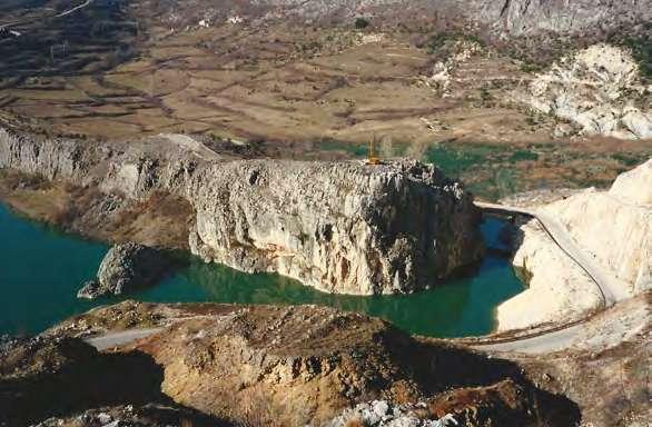
6 EXCURSION BROCHURE 1 IMOTSKO POLJE and RESERVOIR RIČICE D.C.3.8 Pilot actions Imotsko polje and South Dalmatia springs Investigations have found that the springs of the Vrljika River (Opačac and others) are completely independent of nearby lakes. Imotsko polje is faced with two basic problems: seasonal flooding and intensive agricultural activity (pollution and increased water demand). A major part of Imotsko polje was being flooded by Suvaja (Ričina) until Ričice reservoir (known as Zeleno lake ) and channel system have been built. The construction of the multifunctional Ričice reservoir was possible due to natural conditions of wider Ričice village area, located in the valley of intermittent Ričina River and its tributary Vrbice (Bojanić and Ivičić, 1978). The accumulation area is mainly built out of Promina deposits: marl complex, marly limestones and sandstones. These deposits are entirely impermeable. Bauxite can be found in the right side of the dam and in places where older Eocene limestones ( Ma) meet these deposits. 3 Fig. 2. Ričice reservoir Limestones and limestone breccia that form the higher parts of right side of the reservoir, part of the terrain near Parlov, carbonate area Kotao and bridge across Ričina River towards Ričice, represent permeable deposits.
7 Tectonic cracks, fractures, channels, caverns etc. contribute to the permeability of mentioned deposits. According to the structural-tectonic observation of carbonate deposits within the accumulation area, certain parts have the predisposition for potential groundwater pathways through which water flows towards Imotsko polje. These pathways can be defined as rather permeable zones than privileged pathways (Buljan et al., 1997). Water losses from the reservoir can be related to these permeable zones, which prevent exceeding of the foreseen maximum water level. Unfortunately, proposed observations and measurements that encompass controlled water discharge through the main outlet were not executed according to the programme. Technical solutions are required to tackle the water losses, after their location and quantity is determined. At the time of small and medium water levels, the water losses from the reservoir lake can be linked to the most upstream carbonate part of the accumulation. The percolation also occurs in case of water level reaching the carbonates in right embankment. Without further investigation, the quantification of losses between these two areas is not possible. Fig. 3. Ričice reservoir 4
8 EXCURSION BROCHURE 2 IMOTSKI LAKES: Crveno and Modro lakes 5 D.C.3.8 Pilot actions Imotsko polje and South Dalmatia springs Lakes of Imotski are a specific hydrogeological phenomena. Crveno Lake was described a number of times, but the data regarding its morphology is not consistent. Northwestern part of the Crveno Lake is almost vertical, while the southeast part has an inclination of 45 degrees. Garašić (2000) believes that the bottom of the lake is situated on -6 m below sea level, and according to Roglić (1938) the maximum registered water level was 320 m a.s.l. Fig. 4. Crveno Lake Modro Lake is located 550 m southeast of Crveno Lake. The lake s width is 230 m in NE-SW direction, and 90 m in NW-SE. According to Petrik (1960) the bottom of the lake is on 239 m a.s.l., and the maximum water level according to Roglić (1938) was 345 m a.s.l. Slišković and Ivičić (1999) explain the fluctuation of water levels in these lakes and other ones located within polje with separate hydrological systems inflow and outflow of Modro Lake through bottom and inflow and outflow through lateral channels of Crveno Lake. Two processes are happening simultaneously. The first one being dissolution and erosional destruction of the karstic underground via groundwater flow, resulting in branching out and accumulation of karstic forms.
9 The second process is the general relief reduction due to exogenous factors (dissolution, water, wind and ice erosion, abrasion) which causes resurfacing of the accumulated karst underground shapes. In the Late Miocene, a rather large lake existed in the area around Imotski, with swallow holes at its SW border. Through these swallow holes the water flowed down to the existing erosional base. Subsequent neotectonic activity dissected the area and differential movements of blocks caused the desiccation of the lake and the swallow holes ceased to function. Later on, the collapse processes of the margins plugged the swallow holes which were thus transformed into very deep pit (Crveno Lake) and/or huge sinkholes (Modro Lake). It is important to note that the Crveno and Modro Lakes are unique shapes, even for karst morphology. However, from geological and hydrogeological point of view, they do not represent extraordinary karst landscape forms, because they fit into the described origin scenario of the wider geological and hydrogeological area. Their morphological grandeur is a result of huge quantity of water in time of their formation, big gradient between the water sink altitude and closest local erosional base, and the tendency of the wider area for the development of karstic hydrogeology. Fig. 5. Modro Lake 6
10 EXCURSION BROCHURE 3 KARST SPRING PRUD 4 BAĆINA LAKES 7 D.C.3.8 Pilot actions Imotsko polje and South Dalmatia springs The Dinaric karst is a locus typicus for karst morphology, and it is quite famous in the hydrogeological community. It is determined by very deep and irregular karstification caused by compressive tectonics and an accumulation of soluble carbonates which can reach up to several km in thickness. The geology, tectonics, and structural framework of the Croatian Dinaric karst region have been reported in numerous publications; however, the evolution of the region is still a matter of debate and fundamental research (Vlahović et al., 2005; Velić, 2007; Korbar, 2009). Delineation of catchments in such karstic terrains is very difficult and numerical modelling is practically impossible. Numerous methods should be applied and systems have to be divided into mutually dependent catchments and sub-catchments (Terzić et al., 2012, 2014). The Baćina Lakes have been studied recently within one scientific hydrogeological project funded by Croatian Waters (Tezić et al., 2015) - together with limnological research, and partially within the Drinkadria project (funded by EU within IPA Adriatic Programme) and still ongoing PROLINE-CE project (funded by EU within Interreg CE Programme). Preliminary results have been reported in a few publications (Lukač Reberski et al., 2016, 2016a; Terzić et al., 2015a). The Prud karst spring and Baćina Lakes belong to the discharge zone common to both the South-Dalmatian and West-Herzegovinian Dinaric karst catchments. Although the Prud spring is situated in Croatia, most of its catchment is in Bosnia and Herzegovina, which raises transboundary issues considering groundwater protection zones and water use. The spring is used for extraction for the water supply of Metković town, and also the more widespread water utility NPKL (Neretva River - Pelješac Peninsula - Korčula Island - Lastovo Island). The water is generally of decent quality, and only concentrations of sulfate ions are increased, as a consequence of the dissolution of gypsum and anhydrites in the Herzegovinian underground.
.")
.")
11 Fig. 6. Prud spring Fig. 7. Prud spring The Baćina Lakes are situated to the south of the Prud spring, close to the Adriatic Sea coast near the town of Ploče. They are composed of seven lakes (Crniševo, Očuša, Podgora, Vrbnik, Sladinac, Vitanj and Plitko). Within their zone there are several springs, and also a tunnel which drives water from the upper zones (karst polje Jezero near Vrgorac; constructed in 1938) and the tunnel which drains water from the lakes into the sea (constructed in 1913). The deepest lake of Crniševo is subject to the underground influence of seawater penetration, and is also polluted by local waste disposal. 8

 as the most")

12 EXCURSION BROCHURE D.C.3.8 Pilot actions Imotsko polje and South Dalmatia springs 3 KARST SPRING PRUD 4 BAĆINA LAKES Fig. 8. Tunnel from Baćina Lakes to Vrgoračko polje Close to the lakes there is the Klokun karst spring, which is used as a water supply source for Ploče town and its surroundings. The discharge zone spreads from the right boundary of the Neretva river valley. The first spring in Croatia is the Prud, then there are several karst springs, especially in the Desne area with Modro oko (local water supply) as the most important one. Close to the Baćina Lakes and the zone finishes with the coastal spring Mandina mlinica, after which the flysch rock barrier influences the groundwater flow, also preventing extensive penetration of seawater into the aquifer. Therefore, after Mandina mlinica there is no important karst spring or vrulja (submarine spring) for over 50 km along the coast of the Adriatic Sea. 9 Fig. 9. Baćina Lakes
, many uncertainties and problems with interpretation still exist.")
. Fig. 10.")
13 Hydrogeological relationships in this karst terrain are very complex and interrelated. Although there has been lots of exploration to date (including tracing experiments), many uncertainties and problems with interpretation still exist. Groundwater, surface flows which sink and reappear, karst springs, poljes, estavelles, vruljas and swallow holes, speleological features, and their mutual relationships represent big challenges for hydrogeological researchers even today (Bonacci et al., 2013; Ivičić, 2000; Slišković, 2014; Terzić et al., 2015). Fig. 10. Baćina Lakes Within the most recent study, this big catchment area (total surface 1757 km 2 ) was taken as a hydrogeological system and divided into several sub-catchments which interrelate depending on any given moment in a hydrological cycle. To make this terrain even more complex, there are quite a lot of man-made interventions: a network of canals in karst poljes, tunnels draining water from karst poljes, and artificial barriers such as small dams. This recent delineation has to consider big parts of terrain in Bosnia and Herzegovina, although most of the hydrogeological and hydrochemical exploration has been performed in Croatia. 10

.")
14 EXCURSION BROCHURE 3 KARST SPRING PRUD 4 BAĆINA LAKES D.C.3.8 Pilot actions Imotsko polje and South Dalmatia springs All these issues raise questions of transboundary protection of spring water which is being extracted for public water supply use (Prud, Klokun, Modro oko, Butina, Banja). Generally, the water is of good quality, and the hydrochemical facies vary from the Ca-HCO3 type (usual for karst waters), to somewhere close to Na-Cl (mixing with the sea in coastal zones) or Ca-SO (proof of sulfate rocks). This research is being continued and particular importance will be given to stable isotope measurements, especially establishment of the local meteoric water line (LMWL) because there has been no such research in this area before. Fig. 11. Hydrographic network of the Pilot area South Dalmatia: Prud, Klokun and Mandina springs 11
15 12

16 EXCURSION BROCHURE D.C.3.8 Pilot actions Imotsko polje and South Dalmatia springs NOTES 13
17 14
18 EXCURSION BROCHURE D.C.3.8 Pilot actions Imotsko polje and South Dalmatia springs Bojanić, L. & Ivičić, D. (1978): Akumulacija Ričice, hidrogeološki radovi (Ričice reservoir, hydrogeological work). Expert documents of the Institute for geological exploration, Zagreb. Bonacci, O., Željković, I. & Galić, A. (2013): Karst rivers particularity: an example from Dinaric karst (Croatia/Bosnia and Herzegovina), Environ. Earth Sci. 70: Buljan, R., Ivičić, D. & Kapelj, S. (1997): Akumulacija Ričice, hidrogeološki istražni radovi u Godini (Ričice reservoir, hydrogeological exploration in 1997). Expert documents of the Institute for geological exploration, Zagreb. Garašić, M. (2000): Speleohidrološka istraživanja Crvenog jezera kraj Imotskog u Dinarskom kršu (Hrvatska) (Speleohydrological investigations of the Crveno lake near Imotski in the Dinaric karst, Croatia). In: Vlahović, I. & Biondić, R. (ed.): 2.hrvatski geološki kongres (Second Croatian Geological Congress), Cavtat-Dubrovnik, Proceedings, , Zagreb. Ivičić, D. (2000): Sliv izvora desne strane donjeg toka Neretve (Catchment of springs on right bank of Neretva River), Vodič ekskurzija 2. hrvatskog geološkog kongresa u Cavtatu (Excursion book, 2nd Croatian geological congress), Hrvatski geološki institut, Zagreb. REFERENCES Korbar T. (2009): Orogenic evolution of the External Dinarides in the NE Adriatic region: A model constrained by tectonostratigraphy of Upper Cretaceous to Palegone carbonates, Earth-Science Reviews, 96 (4): doi: /j.earscirev Lukač Reberski, J., Terzić, J., Filipović, M., Frangen, T., & Marković, T. (2016): Impact of land use on groundwater quality in south Dalmatia test area. Cross-border drinking water management. Karleuša, B. & Sušanj, I. (ur.). Rijeka: University of Rijeka, Faculty of Civil Engineering, Lukač Reberski, J., Terzić, J., Frangen, T. & Filipović, M. (2016a): Analiza stabilnih izotopa δ18o i δd u podzemnim i površinskim vodama šireg slijeva izvora Prud (Stable isotope δ18o and δd analysis in groundwater and surface water in the Prud spring catchment). Međunarodni znanstveno-stručni skup Čovjek i krš Knjiga sažetaka (Proceedings of international conference Man and karst ) / Simone Milanolo, Jasminko Mulaomerović (ur.). Sarajevo : Garmond Fig. 12. Flooded Vrgorac polje
19 Petrik, M. (1960): Hidrografska mjerenja u okolici Imotskog (Hydrographic investigations in the Imotski area) Ljetopis JAZU, 64, , Zagreb. Roglić, J. (1938): Imotsko polje (physical geographic characteristics). Posebna izd. Geogr. Društva (Special edition of the Geographical Society), 21, 1-125, Beograd. Slišković, I. & Ivičić, D. (1999): Hidrogeologija sliva i korištenje voda rijeke Trebižat (Hydrogeology and use of water in the Trebižat River catchment area). 2. Croatian water conference, Proceedings, , Dubrovnik. Slišković, I. (2014): Vode u kršu slivova Neretve i Cetine (Water in karst catchments of Neretva and Cetina), Croatian Geological Institute, Zagreb, 171 p. Terzić, J., Lukač Reberski, Jasmina, Frangen, T. & Rubinić, J. (2015): Hidrogeološka i paleolimnološka istraživanja Baćinskih jezera. Knjiga I. Hidrogeološka istraživanja Baćinskih jezera (Hydrogeological research of Baćina Lakes book 1; technical report). Fond HGI 74/15. Terzić, J., Lukač Reberski, J., Frangen, T., Rubinić, J., Boljat, I. & Burić, H. (2015a): Hidrogeološki odnosi dijela južne Dalmacije i Hercegovine (Hydrogeological relations in part of southern Dalmacia and Herzegovina). 5. hrvatski geološki kongres - Knjiga sažetaka (Excursion guidebook, 5th Croatian geological congress). Horvat, M. & Wacha, L. (ur.). Zagreb: Hrvatski geološki institut, Velić, I. (2007): Stratigraphy and Palaeobiogeography of Mesozoic Benthic Foraminifera of the Karst Dinarides (SE Europe). Geologia Croatica 60/1:1-113 Vlahović, I., Tišljar, J., Velić, I. & Matičec D. (2005): Evolution of the Adriatic Carbonate Platform: Palaeogeography, main events and depositional dynamics. Palaeogeography, Palaeoclimatology, Palaeoecology 220: doi: /j. palaeo Fig. 13. Vrgorac polje 16
20 PROLINE-CE project Efficient Practices of Land Use Management Integrating Water Resources Protection and Non-structural Flood Mitigation Experiences The main objective of PROLINE-CE is to improve the protection of drinking water resources as well as protecting regions against floods and droughts in an integrated land use management approach. Project duration PROLINE-CE partnership 13 financing partners and 5 associated partners, originating from 8 central European countries Project budget in total, ERFD funding
Post Congress excursions*:
 Post Congress excursions*: 1. Dubrovnik Ombla - Popovo polje (Vjetrenica) (BiH) HE Trebinje (BiH) Grahovsko polje (MNE) The Boka Kotorska Springs and Kotor Old town (UNESCO heritage site) (MNE) Dubrovnik
Adriatic karstic estuaries, their characteristics and evolution
 Conférence Méditerranéenne Côtière et Maritime EDITION 4, SPLIT, CROATIA (2017) Coastal and Maritime Mediterranean Conference Disponible en ligne http://www.paralia.fr Available online Adriatic karstic
Hydrological data collected for Trebizat river
 LIVING NERETVA, TOWARDS EU STANDARDS IN THE NERETVA RIVER BASIN (BiH) Hydrological data collected for Trebizat river 1 TREBIŽAT hydrological point of view complexity of the natural hydrodynamic water regime
Ecohydrology of karst poljes and their vulnerability
 Ecohydrology of karst poljes and their vulnerability Prof. emeritus O. Bonacci Faculty of Civil Engineering, Architecture and Geodesy, Split University, 21000 Split, Matice hrvatske 15, Croatia E-mail:
Water resources cycle in karst (feasibility studies and engineering design; case studies)
") Water resources cycle in karst (feasibility studies and engineering design; case studies) Prof. emeritus Ognjen Bonacci Faculty of Civil Engineering, Architecture and Geodesy, Split University E-mail:
Water resources cycle in karst (feasibility studies and engineering design; case studies) Prof. emeritus Ognjen Bonacci Faculty of Civil Engineering, Architecture and Geodesy, Split University E-mail:
Invitation to CROSS-BORDER DRINKING WATER MANAGEMENT. International Symposium: 29 th January Rijeka, Croatia
 Invitation to International Symposium: CROSS-BORDER DRINKING WATER MANAGEMENT 9 th January 06 Rijeka, Croatia Faculty of Civil Engineering University of Rijeka Radmile Matejčić 3 5000 Rijeka Croatia Rijeka,
The Timok River Basin in Serbia
 The Timok River Basin in Serbia UNECE Workshop on Integrated Transboundary Water Resources Management in SEE, Sarajevo, 18-20 May, 2009 Dragana Ninković, Dipl.-Ing. Dušan Dobričić, Dipl.-Ing. Content 1.
Protection and Sustainable Use of the Dinaric Karst Transboundary Aquifer System
 Protection and Sustainable Use of the Dinaric Karst Transboundary Aquifer System Second Workshop "River Basin Commissions and Other Joint Bodies for Transboundary Water Cooperation: Technical Aspects "
Extraordinary summer flood in a karst area: case study in Croatia
 The Extremes ofthe Extremes: Exlraordinan' Floods (Proceedings ol'a symposium held at Reykjavik. Iceland. July 2000). IAHS Publ. no. 271. 2002. 133 Extraordinary summer flood in a karst area: case study
Protection and Sustainable Use of the DINARIC KARST AQUIFER SYSTEM
 Protection and Sustainable Use of the DINARIC KARST AQUIFER SYSTEM 1. the context What is Karst? Karst is a special type of geologic environment that is formed by dissolution and corrosion of soluble rocks,
Excursion guidebook. Dubrovnik (Ombla) - Blue and Red Lakes (Imotski) - Gacka River - Plitvička Lakes - Zagreb - Ljubljana
 - Blue and Red Lakes (Imotski) - Gacka River - Plitvička Lakes - Zagreb - Ljubljana") 44 th Annual Congress of the IAH Groundwater Heritage and Sustainability Excursion guidebook Dubrovnik (Ombla) - Blue and Red Lakes (Imotski) - Gacka River - Plitvička Lakes - Zagreb - Ljubljana 25 th
44 th Annual Congress of the IAH Groundwater Heritage and Sustainability Excursion guidebook Dubrovnik (Ombla) - Blue and Red Lakes (Imotski) - Gacka River - Plitvička Lakes - Zagreb - Ljubljana 25 th
Hazards caused by natural and anthropogenic changes of catchment area in karst
 Natural Hazards and Earth System Sciences (004) 4: 655 66 SRef-ID: 684-998/nhess/004-4-655 European Geosciences Union 004 Natural Hazards and Earth System Sciences Hazards caused by natural and anthropogenic
Blocking Sea Intrusion in Brackish Karstic Springs
 European Water 1/2: 17-23, 3. 3 E.W. Publications Blocking Sea Intrusion in Brackish Karstic Springs The Case of Almiros Spring at Heraklion Crete, Greece A. Maramathas, Z. Maroulis, D. Marinos-Kouris
Danube River Basin District
 Ministry of Agriculture, Forestry and Water Management June 18 th, 2004 Danube River Basin District Part B - Report 2003 CROATIA Information required according to Art. 3 (8) and Annex I of the EU Water
REPORT of the visit of eminent experts in karstоlogy Derek Ford and Petar Milanović to the Centre for Karst Hydrogeology
 REPORT of the visit of eminent experts in karstоlogy Derek Ford and Petar Milanović to the Centre for Karst Hydrogeology In honour of the Petar Milanović s 80 th birthday, Centre for Karst Hydrogeology
SUPPORT TO WATER RESOURCES MANAGEMENT IN THE DRINA RIVER BASIN DRAFT ROOF REPORT INTRODUCTION AND GENERAL APPROACH
 SUPPORT TO WATER RESOURCES MANAGEMENT IN THE DRINA RIVER BASIN DRAFT ROOF REPORT INTRODUCTION AND GENERAL APPROACH Nadja Zeleznik, REC Public Concultation Beograd, Serbia, 4 July 2017 1 1. Introduction
Karst Without Boundaries
 International Conference and Field Seminar Karst Without Boundaries In partnership of In collaboration with Other supporting partners and organizations P R O C E E D I N G S Edited by N. Kukurić, Z. Stevanović,
3.0 OVERVIEW OF HUECO BOLSON
 3.0 OVERVIEW OF HUECO BOLSON The Hueco Bolson covers about 2,500 square miles, or 1.6 million acres in New Mexico, Texas, and Chihuahua (Figure 3-1). In Texas, the Hueco overlies portions of El Paso and
Seasonal Variability of the Groundwater Regime for Several Aquifers in Bulgaria Tatiana Orehova 1
 Seasonal Variability of the Groundwater Regime for Several Aquifers in Bulgaria Tatiana Orehova 1 The purpose of the paper is to analyse the seasonal variability of the groundwater regime for several aquifers
ARTIFICIAL RECHARGE OF THE UNDERGROUND KARSTIC AQUIFER OF FARSALA AREA (THESSALY, CENTRAL GREECE) 1
 1") ARTIFICIAL RECHARGE OF THE UNDERGROUND KARSTIC AQUIFER OF FARSALA AREA (THESSALY, CENTRAL GREECE) 1 MARIOLAKOS, I. 2, FOUNTOULIS, I., SPYRIDONOS, E., MARIOLAKOS, D., ANDREADAKIS, EM. ABSTRACT The area
ARTIFICIAL RECHARGE OF THE UNDERGROUND KARSTIC AQUIFER OF FARSALA AREA (THESSALY, CENTRAL GREECE) 1 MARIOLAKOS, I. 2, FOUNTOULIS, I., SPYRIDONOS, E., MARIOLAKOS, D., ANDREADAKIS, EM. ABSTRACT The area
Hydrological study for the operation of Aposelemis reservoir Extended abstract
 Hydrological study for the operation of Aposelemis Extended abstract Scope and contents of the study The scope of the study was the analytic and systematic approach of the Aposelemis operation, based on
Excursion guidebook. Arboretum Trsteno - Koločep Bay - Ston. 44 th Annual Congress of the IAH Groundwater Heritage and Sustainability
 44 th Annual Congress of the IAH Groundwater Heritage and Sustainability Excursion guidebook Arboretum Trsteno - Koločep Bay - Ston 25 th - 29 th September 2017, Hotel Dubrovnik Palace, Croatia HONORARY
Protection and Sustainable Use of the Dinaric Karst Transboundary Aquifer System
 Protection and Sustainable Use of the Dinaric Karst Transboundary Aquifer System What is DIKTAS? DIKTAS is a project initiated by the aquifer-sharing states and supported by GEF - Global Environment Facility.
Prosjekt Lesina Mediteranean sea Coastal lagoon
 Prosjekt Lesina Mediteranean sea Coastal lagoon PERIODE 2012-2015 LAND The Lesina Lagoon, alternatively known as the Lake of Lesina due to its small and previously fleeting hydrological connection to the
There are actually six geographic sub-regions, three in both the uplands and the lowlands.
 6 Regions of AR Although Arkansas is most easily divided into two distinct geographical regions, the northwestern uplands and the southeastern lowlands, this description does not accurately portray the
Visit of Chinese representatives of the International Research Centre for Karst (IRCK) to the CKH
 to the CKH") Visit of Chinese representatives of the International Research Centre for Karst (IRCK) to the CKH The International Research Center on Karst (IRCK) was formed in 2008 in Guilin, China under the Auspices
Visit of Chinese representatives of the International Research Centre for Karst (IRCK) to the CKH The International Research Center on Karst (IRCK) was formed in 2008 in Guilin, China under the Auspices
PORTISHEAD BRANCH LINE PRELIMINARY ENVIRONMENTAL INFORMATION REPORT VOLUME 4 APPENDIX Water Receptors
 PORTISHEAD BRANCH LINE PRELIMINARY ENVIRONMENTAL INFORMATION REPORT APPENDIX 17. 3 Water Receptors Contents Section Page 1 Water Receptors... 1-1 1.1 Surface Water Features/Receptors in the Study Area
HYDRAULIC STUDY OF THE NERETVA RIVER (FROM MOSTAR TO THE BORDER WITH THE REPUBLIC OF CROATIA)
") HYDRAULIC STUDY OF THE NERETVA RIVER (FROM MOSTAR TO THE BORDER WITH THE REPUBLIC OF CROATIA) B.Sc. Draženka Kvesić, civ. eng. PRONING DHI d.o.o., Račkog 3, Zagreb Croatia. Email: drazenka@proning-dhi.hr.
HYDRAULIC STUDY OF THE NERETVA RIVER (FROM MOSTAR TO THE BORDER WITH THE REPUBLIC OF CROATIA) B.Sc. Draženka Kvesić, civ. eng. PRONING DHI d.o.o., Račkog 3, Zagreb Croatia. Email: drazenka@proning-dhi.hr.
Procedia Earth and Planetary Science 13 ( 2015 ) th Applied Isotope Geochemistry Conference, AIG-11 BRGM
 th Applied Isotope Geochemistry Conference, AIG-11 BRGM") Available online at www.sciencedirect.com ScienceDirect Procedia Earth and Planetary Science 13 ( 2015 ) 256 260 11th Applied Isotope Geochemistry Conference, AIG-11 BRGM Investigating the Origin and Interaction
Available online at www.sciencedirect.com ScienceDirect Procedia Earth and Planetary Science 13 ( 2015 ) 256 260 11th Applied Isotope Geochemistry Conference, AIG-11 BRGM Investigating the Origin and Interaction
Example of transnational EU projects Croatian Hydrographic Institute
 Plenary session of the European IHO network (IENWG) 27th February, Official French Representation, Brussels Example of transnational EU projects Croatian Hydrographic Institute www.hhi.hr Vinka Kolić,
1. TITLE OF THE PROJECT HYDROPOWER SYSTEM UPPER HORIZONS. 2. SECTOR Energy
 1. TITLE OF THE PROJECT HYDROPOWER SYSTEM UPPER HORIZONS 2. SECTOR Energy 3. LOCATION The term Upper Horizons means the undeveloped part of the hydropower system Trebišnjica, which is located above the
Multicriteria flood mitigation in the Imotsko-Bekijsko Polje (Croatia, Bosnia and Herzegovina)
") DOI: 10.1515/jwld-2015-0018 Polish Academy of Sciences, Committee for Land Reclamation JOURNAL OF WATER AND LAND DEVELOPMENT and Environmental Engineering in Agriculture, 2015 2015, No. 26 (VII IX): 73
DOI: 10.1515/jwld-2015-0018 Polish Academy of Sciences, Committee for Land Reclamation JOURNAL OF WATER AND LAND DEVELOPMENT and Environmental Engineering in Agriculture, 2015 2015, No. 26 (VII IX): 73
J.M. Marques a, C. Matos b, P.M. Carreira c and M.O. Neves a
 GEOCHEMICAL AND ISOTOPIC TOOLS TO ASSESS CALDAS DA RAINHA THERMOMINERAL WATER SYSTEM ASCRIBED TO A KARST/FISSURED-POROUS ENVIRONMENT (PORTUGAL): A REVIEW J.M. Marques a, C. Matos b, P.M. Carreira c and
Groundwater Vulnerability in Western Herzegovina
 1 Paper N 0 : V.11 Groundwater Vulnerability in Western Herzegovina Mladen Zelenika, Ivan Slišković, Božo Soldo Abstract: The full and partial hydrogeological barriers together with terrains of low and
"Transboundary coordination according to the FD Directive in the shared river basins of Greece
 Workshop on Transboundary Issues Budapest March 31st April 1st "Transboundary coordination according to the FD Directive in the shared river basins of Greece Katerina Triantafyllou, ECOS Consulting S.A.
Breakthrough of the Tunnel with the Biggest Overburden in Croatia
 289 Breakthrough of the Tunnel with the Biggest Overburden in Croatia Redovnikovi, L., Ališi, I., and Džapo, M. University of Zagreb, Faculty of Geodesy, Fra Andrija Ka i a Mioši a 26, 1 Zagreb, Croatia,
The search results explanations of hydrological data
 Introduction The search results explanations of hydrological data Depending on the parameter, the instrumental measuring or visual observation method is used for the hydrological observations. Instrumentally
Caves of Mt. Miroč (Danube Gorge, Eastern Serbia)
") Caves of Mt. Miroč (Danube Gorge, Eastern Serbia) Vladimir LJUBOJEVIĆ Student Speleologic and Alpinistic Club (ASAK), Studentski trg 16, 11000 Belgrade, Yugoslavia fric@sezampro.yu Abstract Mt. Miroč is
Caves of Mt. Miroč (Danube Gorge, Eastern Serbia) Vladimir LJUBOJEVIĆ Student Speleologic and Alpinistic Club (ASAK), Studentski trg 16, 11000 Belgrade, Yugoslavia fric@sezampro.yu Abstract Mt. Miroč is
HYDROGEOLOGICAL RESEARCH OF THE CROATIAN PART OF THE TRANSBOUNDARY AQUIFERS (HR-SI) BETWEEN KVARNER BAY AND TRIESTE BAY
 BETWEEN KVARNER BAY AND TRIESTE BAY") Workshop on the protection of groundwater as a source of drinking water in karst areas April 14-15, 2008, Malinska - CROATIA HYDROGEOLOGICAL RESEARCH OF THE CROATIAN PART OF THE TRANSBOUNDARY AQUIFERS
Workshop on the protection of groundwater as a source of drinking water in karst areas April 14-15, 2008, Malinska - CROATIA HYDROGEOLOGICAL RESEARCH OF THE CROATIAN PART OF THE TRANSBOUNDARY AQUIFERS
THE IMPLEMENTATION OF EWFD/WFD IN THE REGION OF VOJVODINA WITHIN JOINT SLOVAK-SERBIA SERBIA PROJECTS
 Towards Integrated River Basin Management The 55 th Anniversary of the Founding of the Water Research Institute THE IMPLEMENTATION OF EWFD/WFD IN THE REGION OF VOJVODINA WITHIN JOINT SLOVAK-SERBIA SERBIA
Geologia Croatica. The conceptual hydrogeological model of the Plitvice Lakes. Božidar Biondić, Ranko Biondić and Hrvoje Meaški AB STRA CT
 63/2 195 206 16 Figs. 1 Tab. Zagreb 2010 195 The conceptual hydrogeological model of the Plitvice Lakes Božidar Biondić, Ranko Biondić and Hrvoje Meaški AB STRA CT Faculty of Geotechnical Engineering,
Settlement Patterns West of Ma ax Na, Belize
 SETTLEMENT PATTERNS WEST OF MA AX NA, BELIZE 1 Settlement Patterns West of Ma ax Na, Belize Minda J. Hernke Faculty Sponsor: Kathryn Reese-Taylor, Department of Sociology/Archaeology ABSTRACT The focus
DETECTION OF WATER LEAKS IN FOUM EL-GHERZA DAM (ALGERIA)
") Ninth International Water Technology Conference, IWTC9 2005, Sharm El-Sheikh, Egypt 581 DETECTION OF WATER LEAKS IN FOUM EL-GHERZA DAM (ALGERIA) N. Hocini and A.S. Moulla Applied Hydrology and Sedimentology
Ninth International Water Technology Conference, IWTC9 2005, Sharm El-Sheikh, Egypt 581 DETECTION OF WATER LEAKS IN FOUM EL-GHERZA DAM (ALGERIA) N. Hocini and A.S. Moulla Applied Hydrology and Sedimentology
EL PASO S DESALINATION EFFORTS
 El Paso s Desalination Efforts WATER DESALINATION AND REUSE STRATEGIES FOR NEW MEXICO SEPTEMBER NEW MEXICO WATER RESOURCES RESEARCH INSTITUTE 2004 Bill Hutchison has more than 20 years of experience as
Danube River Basin District
 Danube River District Part B - Report 2003 ROMANIA Information required according to Art. 3 (8) and Annex I of the EU Water Framework Directive Reporting deadline: June 22, 2004 Prepared by National Administration
Implementation of WFD in Serbia and Montenegro
 Ministry of Agriculture, Forestry and Water Management Directorate for Water Implementation of WFD in Serbia and Montenegro Nikola Marjanovic, PhD Civ. Eng. SERBIA AND MONTENEGRO SERBIA Area: 88.361 km
Benton County Karstic Mapping Project. Barbara France, Dustin Kochen, Tiffany Clark, John Maloney Paul Lowery's Environmental Geology
 Benton County Karstic Mapping Project Barbara France, Dustin Kochen, Tiffany Clark, John Maloney Paul Lowery's Environmental Geology Intro Karst refers to an area of bedrock that is very susceptible to
Transboundary and Not-Tranboundary Aquifers in the Basin
 Second Assessment of Transboundary Rivers, Lakes and Groundwaters under the UNECE Water Convention Transboundary and Not-Tranboundary Aquifers in the Basin Slovak Hydrometeorological Institute Bratislava,
International Groundwater Resources Assessment Centre. Transboundary Aquifers within the Second Assessment: the case of Dinaric Karst Aquifer System
 International Groundwater Resources Assessment Centre Transboundary Aquifers within the Second Assessment: the case of Dinaric Karst Aquifer System Dr Neno Kukuric Sarajevo, 2009 Content of the presentation
ORTHOLOGICAL MANAGEMENT OF HYDROLOGICAL RUNOFF BASINS OF THE PREFECTURE OF DRAMA (CURRENT SITUATION PROTECTIVE ACTIONS PERSPECTIVES)
") ORTHOLOGICAL MANAGEMENT OF HYDROLOGICAL RUNOFF BASINS OF THE PREFECTURE OF DRAMA (CURRENT SITUATION PROTECTIVE ACTIONS PERSPECTIVES) This paper presents the torrential environment of the torrents of the
ORTHOLOGICAL MANAGEMENT OF HYDROLOGICAL RUNOFF BASINS OF THE PREFECTURE OF DRAMA (CURRENT SITUATION PROTECTIVE ACTIONS PERSPECTIVES) This paper presents the torrential environment of the torrents of the
Transboundary Water Management in Republic of Macedonia
 12th International Conference EUROPE-INBO 2014 12-15 November 2014, Bucharest, Romania. Transboundary Water Management in Republic of Macedonia Ylber Mirta Head of Department for Waters ymirta@gmail.com
MIÑO O AND LIMIA BASINS
 Miño-Sil MIÑO O AND LIMIA BASINS José Álvarez Díaz Sil River Basin District s s Planning Office, Spain WORKSHOP ON TRANSBOUNDARY WATER RESOURCES BUDAPEST, HUNGARY, 8-10 FEBRUARY 2011 INDEX 1. OVERVIEW
Stephanie C. Haas Digital Library Center University of Florida Libraries Gainesville, FL
 OF FRACTURED EARTH AND LIQUID GEMS: THE SPRINGS OF FLORIDA Stephanie C. Haas Digital Library Center University of Florida Libraries Gainesville, FL haas@smathersnt2.uflib.ufl.edu Springs occur in the fractured
Intermediate report. Letter of agreement FAO - GCB/RAB/013/ITA
 Treated waste water for sustainable production of valuable biomass, soil and water quality improvement and combating desertification in Algeria and Tunisia Letter of agreement FAO - GCB/RAB/013/ITA Intermediate
The Isonzo/Soca river basin
 Geneva September 8 th 2014 The Isonzo/Soca river basin Status and perspective on the possible Alpine river basin to be assessed The Alpine Convention Water management, risk management and adaptation to
The Impact of Human Activities on Dolines (Sinkholes) Typical Geomorphologic Features on Karst (Slovenia) and Possibilities of their Preservation
 Typical Geomorphologic Features on Karst (Slovenia) and Possibilities of their Preservation") ISSN 0354-8724 (hard copy) ISSN 1820-7138 (online) The Impact of Human Activities on Dolines (Sinkholes) Typical Geomorphologic Features on Karst (Slovenia) and Possibilities of their Preservation Cernatič-Gregorič
ISSN 0354-8724 (hard copy) ISSN 1820-7138 (online) The Impact of Human Activities on Dolines (Sinkholes) Typical Geomorphologic Features on Karst (Slovenia) and Possibilities of their Preservation Cernatič-Gregorič
Its capacity function will again consist of two parts:
 1.4.2. Tunnel Fatničko polje and Beleća reservoir (FP->BR) At the time of the study, the tunnel was in the final stages of construction. The tunnel is much longer than DP->FP and has a steeper slope (S=
Presentation from 2015 World Water Week in Stockholm. The authors, all rights reserved. SIWI siwi.org
 Presentation from 2015 World Water Week in Stockholm www.worldwaterweek.org The authors, all rights reserved SIWI siwi.org WORLD WATER WEEK Stockholm, 23 th August 2015 Co-operative water governance: catalyst
Wind Power Plant Podveležje
 Wind Power Plant Podveležje Public Information Meeting Mostar, Topics 1. PROJECT BACKGROUND AND OBJECTIVES 2. PROJECT DESCRIPTION 3. PERMITTING STATUS 4. DESCRIPTION OF THE ENVIRONMENTAL CONDITIONS Physical
Geoscape Toronto The Oak Ridges Moraine Activity 2 - Page 1 of 10 Information Bulletin
 About 13,000 years ago as the Laurentide Ice Sheet melted, glacial meltwater accumulated between the ice sheet and the Niagara Escarpment. This formed a lake basin into which gravel and sand were deposited.
Long Island Subglacial Drainage Patterns Reveal the Direction of Glacial Flow
 Long Island Subglacial Drainage Patterns Reveal the Direction of Glacial Flow Waldemar Pacholik Introduction: The debate regarding the chronology of the development of Long Island s (LI s) topography is
REPORT Of the Symposium KARST 2018 EXPECT THE UNEXPECTED Trebinje, Bosnia & Herzegovina June, 2018.
 REPORT Of the Symposium KARST 2018 EXPECT THE UNEXPECTED Trebinje, Bosnia & Herzegovina 06-09. June, 2018. The Symposium under the name Karst 2018 Expect the unexpected was organised in the honour of 80th
P-46 The Karstic system of the Kerketio Mountain (Koziakas) and its exploitation. by George Bathrellos*, Efthimia Verikiou**, Hariklia Skilodimou***
 and its exploitation. by George Bathrellos*, Efthimia Verikiou**, Hariklia Skilodimou***") P-46 The Karstic system of the Kerketio Mountain (Koziakas) and its exploitation. by George Bathrellos*, Efthimia Verikiou**, Hariklia Skilodimou*** Abstract The Kerketio or Koziakas Mountain is the eastern
P-46 The Karstic system of the Kerketio Mountain (Koziakas) and its exploitation. by George Bathrellos*, Efthimia Verikiou**, Hariklia Skilodimou*** Abstract The Kerketio or Koziakas Mountain is the eastern
c. 1 inch = 0.6 miles e. 1:100,000 f. 1:250,000 f. 1 inch = 4.0 miles
 High School Advance Geology Map Test 2014 Name Use the information on each map to provide the best answer to the questions. Fill in the bubble of the best answer on your answer sheet. Answer questions
Appendix A Geographic and Geologic Terms Connected With Egypt
 Appendix A Geographic and Geologic Terms Connected With Egypt Egypt Official name is the Arab Republic of Egypt. Total area is 1,002,450 km 2, which makes Egypt the 29th largest country in the world. Only
Glacial Origins and Features of Long Island
 Glacial Origins and Features of Long Island Interior Coastal Plain Continental Shelf Long Island s Geology 0 Ma Phanerozoic 540 Ma Proterozoic 2500 Ma Archean 3800 Ma Hadean 4600 Ma C M P Geologic Time
Investment possibilities of municipal formation KINGISEPP MUNICIPAL DISTRICT. This project is funded by the European Union
 Investment possibilities of municipal formation KINGISEPP MUNICIPAL DISTRICT This project is funded by the European Union Kingisepp municipal district is situated in the South-West of Leningrad Region.
Protection and Sustainable Use of the Dinaric Karst Transboundary Aquifer System. Transboundary Diagnostic Analysis
 Protection and Sustainable Use of the Dinaric Karst Transboundary Aquifer System Transboundary Diagnostic Analysis December 2013 Executive Summary The Transboundary Diagnostic Analysis (TDA) described
Stability determination of ceilings of some caves
 International Journal of Geoheritage. 2015, 3(2): 24-32 DOI: 10.17149/ijg.j.issn.2210.3382.2015.02.004 2015 Darswin Publishing House Stability determination of ceilings of some caves Ivaylo Ivanov Civil
MANAGING FRESHWATER INFLOWS TO ESTUARIES
 MANAGING FRESHWATER INFLOWS TO ESTUARIES Yuna River Hydrologic Characterization A. Warner Warner, A. (2005). Yuna River Hydrologic Characterization. University Park, Pennsylvania: The Nature Conservancy.
Dragon s Eye a lake in Rogoznica
 Dragon s Eye a lake in Rogoznica Rogoznica Primary School School year 2012/2013 Introduction Coming to Rogoznica from the North and the South side, there are two signs on which it says Dragon s Eye (
Glaciology. Water. Glacier. Moraine. Types of glacier-dammed lakes. Mechanics of jökulhlaup
 A Jökulhlaup Jökulhlaup. Catastrophic events where large amounts of water are suddenly discharged. Jökulhlaup s are a sudden and rapid draining of a glacier dammed lake or of water impounded within a glacier.
INCO: International Scientific Cooperation Projects ( )
") INCO: International Scientific Cooperation Projects (1998-2002) Contract number: ICA2-CT-2002-10009 Covering period from January 1, 2003 to December 31, 2005 Anthropol.prot Title: STUDY OF ANTHROPOGENIC
INCO: International Scientific Cooperation Projects (1998-2002) Contract number: ICA2-CT-2002-10009 Covering period from January 1, 2003 to December 31, 2005 Anthropol.prot Title: STUDY OF ANTHROPOGENIC
Water sustainability: new challenges and solutions IGU Commission for Water Sustainability Dubrovnik, 24 th to 28 th August 2014
 Water sustainability: new challenges and solutions Dubrovnik, 24th to 28th August 2014 FIRST CONFERENCE CIRCULAR and CALL FOR PAPERS Water sustainability: new challenges and solutions International Scientific
2012. Proceedings of the 11 European Geoparks Conference. AGA Associação Geoparque Arouca, Arouca, 5-6.
 References to this volume It is suggested that either the following alternatives should be used for future bibliographic references to the whole or part this volume: th Sá, A.A., Rocha, D., Paz, A. & Correia,
Sandbag Barrier. Suitable Applications Sandbag barriers may be suitable: As a linear sediment control measure:
 Categories EC Erosion Control SE Sediment Control TC Tracking Control WE Wind Erosion Control Non-Stormwater NS Management Control Waste Management and WM Materials Pollution Control Legend: Primary Category
AN ANALISIS OF CITIES ENDANGERMENT OF FLOODS ON THE EXAMPLE OF NOVI SAD
 THE INTERNATIONAL CONFERENCE ON FLOOD MANAGEMENT 25-26.06.2018. BAJA, HUNGARY HIDRO CLB CONSULT 21000 NOVI SAD Kisačka 64 A 381 21 6542 657 AN ANALISIS OF CITIES ENDANGERMENT OF FLOODS ON THE EXAMPLE OF
Framework Agreement on the Sava River Basin and its implementation
 Framework Agreement on the Sava River Basin and its implementation Dejan Komatina, Ph.D. Civ. Eng., Secretary, ISRBC Samo Grošelj, Deputy Secretary Overview Introduction on the Sava river basin Establishment
Natural and man-made flooding hazards at the torrents in the town of Thessaloniki
 Risk Analysis VII PI-373 Natural and man-made flooding hazards at the torrents in the town of Thessaloniki S. Stefanidis, F. Tziaftani & C. Chatzicristaki Institute of Mountainous Water Management and
Overview. Sava River Basin. Sava River Basin. Sava River Basin
 Overview Introduction on the Framework Agreement on the a basis for sustainable development of the region Framework Agreement on the (FASRB) and the International Commission (ISRBC) Approach to Sustainable
TRANSBOUNDARY ASSESSMENT NP PLITVICE LAKES / NP UNA
 Ognjen Škunca & Željka Rajković consultants TRANSBOUNDARY ASSESSMENT NP PLITVICE LAKES / NP UNA 3 2 1 The studied TB region natural historical border between Croatian and B&H in the study area defined
DUSAN SRDOC, NADA HORVATINCIC, and BOGOMIL OBELIC. Faculty of Veterinary Science, University of Zagreb,
 [Radiocarbon, Vol 25, No. 2, 1983,P 421-427] RADIOCARBON DATING OF TUFA IN PALEOCLIMATIC STUDIES DUSAN SRDOC, NADA HORVATINCIC, and BOGOMIL OBELIC Rudjer Boskovic Institute, Zagreb, Yugoslavia, PO Box
Information on Ecological and Biological Significant Marine Areas in Albania
 Information on Ecological and Biological Significant Marine Areas in Albania The report is assembled from the draft strategic plan for marine and coastal protected areas in Albania, supported by the GEF-UNDP
Mr. Michael Malone CPS Energy 145 Navarro Street San Antonio, Texas Project No
 January 15, 2016 Mr. Michael Malone 145 Navarro Street San Antonio, Texas 78205 Project No. 0328985 Environmental Resources Management CityCentre Four 840 West Sam Houston Pkwy N. Suite 600 Houston, Texas
GLACIER STUDIES OF THE McCALL GLACIER, ALASKA
 GLACIER STUDIES OF THE McCALL GLACIER, ALASKA T John E. Sater* HE McCall Glacier is a long thin body of ice shaped roughly like a crescent. Its overall length is approximately 8 km. and its average width
WATER MANAGEMENT IN ROMANIA. Elisabeta CSERWID National Institute of Hydrology and Water Management ROMANIA
 WATER MANAGEMENT IN ROMANIA Elisabeta CSERWID National Institute of Hydrology and Water Management ROMANIA 2 I - Water management in Romania Romania general information Location: S-E Europe Surface: 238,391
Characterization of transboundary aquifers in Dinaric karst - a base study for sustainable water management at regional and local scale
 Characterization of transboundary aquifers in Dinaric karst - a base study for sustainable water management at regional and local scale Zoran Stevanovic 1, Neno Kukuric 2, Holger Treidel 3, Zelimir Pekas
READING QUESTIONS: Chapter 7, Glaciers GEOL 131 Fall pts. a. Alpine Ice from larger ice masses flowing through a valley to the ocean
 READING QUESTIONS: Chapter 7, Glaciers GEOL 131 Fall 2018 63 pts NAME DUE: Tuesday, October 23 Glaciers: A Part of Two Basic Cycles (p. 192-195) 1. Match each type of glacier to its description: (2 pts)
MAPs sector in Bosnia and Herzegovina
 MAPs sector in Bosnia and Herzegovina CEDDEM Decembre 2016 Bosnia & Herzegovina Official Name: Bosnia and Herzegovina (BH) Political system: Parliamentary democracy with a bicameral parliament; BH is composed
Managing water supply resources in karstic environment (temperate climate)
") UNESCO WORKSHOP Integrated Urban Water Management in TC Temperate Climates Belgrade 15-16 May 2006 Managing water supply resources in karstic environment (temperate climate) E. Rozos, D. Koutsoyiannis
UNESCO WORKSHOP Integrated Urban Water Management in TC Temperate Climates Belgrade 15-16 May 2006 Managing water supply resources in karstic environment (temperate climate) E. Rozos, D. Koutsoyiannis
2014 floods in Serbia
 16 th Meeting of WGF, Rim, 9-10 October 2014 2014 floods in Serbia Radovanka Pavlović Ministry of Agriculture and Environmental Protection Republic Water Direcrorate, Belgrade, Serbia Specific cyclone
PPCR/SC.4/5 October 9, Meeting of the PPCR Sub-Committee Washington, D.C. October 28, REVIEW OF ON-GOING WORK OF THE MDBs IN DJIBOUTI
 PPCR/SC.4/5 October 9, 2009 Meeting of the PPCR Sub-Committee Washington, D.C. October 28, 2009 REVIEW OF ON-GOING WORK OF THE MDBs IN DJIBOUTI Proposed Sub-Committee Decision The Sub-Committee reviewed
C R O AT I A I T I N E R A R Y
 CROATIA ITINERARY KOTOR MONTENEGRO DAY 1 KOTOR MONTENEGRO Located in a beautiful bay on the coast of Montenegro, Kotoris a city steeped in tradition and history with remarkable scenic views. A UNESCO World
SIMULATION OF BOSNIA AND HERZEGOVINA AIRSPACE
 SIMULATION OF BOSNIA AND HERZEGOVINA AIRSPACE SECTORIZATION AND ITS INFLUENCE ON FAB CE Valentina Barta, student Department of Aeronautics, Faculty of Transport and Traffic Sciences, University of Zagreb,
WATER RESOURCES IN BOSNIA AND HERZEGOVINA
 Bosna i Hercegovina Agencija za statistiku Bosne i Hercegovine Bosnia and Herzegovina Agency for Statistics of Bosnia and Herzegovina WATER RESOURCES IN BOSNIA AND HERZEGOVINA Water resources in BiH Climate:
Environmental Impact Assessment in Chile, its application in the case of glaciers. Carlos Salazar Hydro21 Consultores Ltda.
 Environmental Impact Assessment in Chile, its application in the case of glaciers Carlos Salazar Hydro21 Consultores Ltda. carlos.salazar@hydro21.cl Introduction Changes in the environmental law in Chile
"ST. KLIMENT OHRIDSKI FACULTY OF GEOLOGY AND GEOGRAPHY
 SOFIA UNIVERSITY "ST. KLIMENT OHRIDSKI FACULTY OF GEOLOGY AND GEOGRAPHY APPLICATION OF THE MODEL "DRIVING FORCES PRESSURE STATE - RESPONSE FOR ASSESSMENT OF FLOOD RISK RADOSTINA BORISOVA DOCHEVA Bachelor
Sava Zagreb Project has to be open to everybody
 Croatian Real Estate Newsletter Volume 89, January 2014 TOPIC OF THIS ISSUE: Interview Leo Penović Sava Zagreb Programme Manager Sava Zagreb Project has to be open to everybody CREN Patrons: TABLE OF CONTENTS
POLLUTION MONITORING OF SHIP EMISSIONS: AN INTEGRATED APPROACH FOR HARBOURS OF THE ADRIATIC BASIN (POSEIDON)
") POLLUTION MONITORING OF SHIP EMISSIONS: AN INTEGRATED APPROACH FOR HARBOURS OF THE ADRIATIC BASIN (POSEIDON) Implementation between 01/06/2014 and 31/05/2015 http://www.medmaritimeprojects.eu/section/poseidon
POLLUTION MONITORING OF SHIP EMISSIONS: AN INTEGRATED APPROACH FOR HARBOURS OF THE ADRIATIC BASIN (POSEIDON) Implementation between 01/06/2014 and 31/05/2015 http://www.medmaritimeprojects.eu/section/poseidon
The Potential of Renewable Energy Sources in Bosnia and Herzegovina
 The Potential of Renewable Energy Sources in Bosnia and Herzegovina Petar M.Gvero, Ph.D.,M.Sc. Assistant Professor Climate Change in South-Eastern European Countries: Causes, Impacts, Solutions Graz, Austria