Water resources cycle in karst (feasibility studies and engineering design; case studies)
|
|
|
- Lindsay Nichols
- 6 years ago
- Views:
Transcription
1 Water resources cycle in karst (feasibility studies and engineering design; case studies) Prof. emeritus Ognjen Bonacci Faculty of Civil Engineering, Architecture and Geodesy, Split University 1
2 1) Catchment in karst 1.1 Žrnovnica karst spring 2) Man s influence on the water regime in the karst terrains 2.1 Zrmanja River catchment 2.2 Rumin Mali & Rumin Veliki karst springs 2
3 CATCHMENT IN KARST 3
4 Catchment area, drainage area or drainage basin - the area of land bounded by watersheds draining into a river basin, spring or reservoir; - the entire geographical area drained by a river and its tributaries, and by spring; - an area characterized by all runoff being conveyed to the same outlet. The determination of the catchment boundaries and the catchment area is the starting point in all hydrological analyses and one of the essential data which serve as a basis for water resources protection, management, understanding and modelling of water circulation through karst massif. 4


5 Definition of karst catchment or basin area and boundaries belongs to the one of greatest problems of karst hydrology and hydrogeology, not adequately solved until now. 5
6 A catchment in karst represents a complex system composed of numerous (generally unknown) and extremely different surface and underground karst formations. Due to its heterogeneity and anisotropy, unexpected water circulation may occur in such a space. An additional problem regarding catchment boundaries and area definition is the fact that connections between surface water and groundwater can change very fast in time and space as a result of both natural processes and anthropogenic interventions. These changes can be either occasional or permanent. Discovery and quantification of these connections is in many cases impossible, which present the main reason why the definition of exact catchment in karst is an extremely complex task, very often unsolvable. For a karst aquifer, the traditional concept of the term ground-water basin is somewhat of a misnomer in that it minimizes the highly interconnected nature of surface and subsurface waters and the role of concentrated stormwater runoff as a significant source of recharge. 6
7 Numerous and extremely different surface and underground karst forms make possible unexpected connections of water in karst medium space which changes in time. Changes of underground flow path during the time are caused by: (1) different recharges from different parts of surface area mainly caused by variable distribution of areal precipitation; (2) different groundwater levels in karst aquifers and their fast changes in time and space; (3) anthropogenic influences; (4) exogenic and endogenic forces. The differences between the topographic and hydrologic catchments in karst terrain are, as a rule, so large that data about the topographic catchment are useless in practice. Determination of a karst catchment is an unreliable procedure due to unknown morphology of underground karst features and their connections with surface karst forms. The variability, in time and space, of karst aquifer as well as conduit parameters make this process extremely sensible and complex. 7
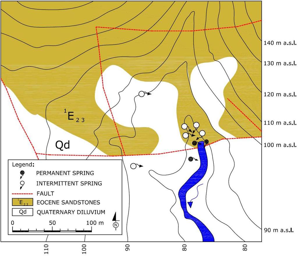
8 A relatively simple example of GWL changes in karst aquifer.? In situation 3 the depressions in karst (mostly poljes) are flooded. Karst spring is designated with, A. The swallow-hole (ponor), B, during the flood can act as spring. In this case it is an estavelle. Catchment boundaries are very fast changeable in time and space. 8
9 Example of the GWL influence on the changes of karst spring catchment area and boundaries 9
10 Schematic presentations of a few possible connections between two neighbouring karst spring aquifers 10
11 Water from the spring, b, can flow by surface stream to the catchment, A, or to any other catchment. Water sinking in the swallow-hole located in the catchment B can reappear in the same catchment or in the catchment, A, as well as in any other catchment. Water sinking in swallow-holes located in the catchment, A, can reappear in the same catchment or in any other catchment excluding the catchment, B. An attempt to present schematically all possible relationships of water circulation between two karst springs (a, and, b) and their topographic catchment areas 11(A, and, B)
12 An attempt to schematically expose a few possible relationships between the aquifers of two karst springs, a, and, b 12
13 Three possible type of flow: (1) flow under pressure in karst conduit; (2) flow with free surface in karst conduit and (3) flow through karst matrix In most cases all three types of flow exist at the same time what depends on structure of contact area and appearance of large karst underground features in it. Along a karst conduit the shape and diameter of its cross-section can vary 13 significantly.
14 Connection between two neighbouring karst spring aquifers Discharge from the spring, b, aquifer to the spring, a, aquifer, Q b-a, depends on dimension of area through which groundwater flow, hydrogeological and hydraulic characteristics of this area and slope of the groundwater piezometic 14 line, i
15 Žrnovnica karst spring The example of the catchment area definition for the karst spring Žrnovnica catchment in Dinaric karst Two simple hydrological methods are used in order to calculate its hydrologic-hydrogeologic catchment: (1) relationship between mean annual discharges and annual rainfall falling on the catchment, (2) Turc method. Topographic catchment area of the Žrnovnica Spring has 8.4 km 2. It is estimated that hydrologic-hydrogeologic catchment area of the Žrnovnica karst spring is much larger and very probably ranges between 60 km 2 and 80 km 2 15.


 Q min = 0.")

16 ŽRNOVNICA SPRING Q mean =1.81 m 3 /s Q max = 19.2 m 3 /s (18 Dec. 2004) Q min = m 3 /s (9, 10, 11, 14 Sep. 1993) 16

17 Location map of the Žrnovnica karst spring showing topographic catchment boundaries and some features crucial 17 for further analysis
18 Hypsometric curve of the topographic catchment 18
19 19
20 Three time series of the Žrnovnica Spring characteristic annual discharges for the period : (1) mean annual, Q AV (violet colour); (2) maximum annual, Q MAX (red colour); (3) minimum annual, Q MIN (dark 20 blue colour)
 mean, Q AV (violet colour); (2) maximum, Q MAX (red colour); (3) minimum, Q MIN (dark blue colour)21")
21 Three time series of the Žrnovnica Spring characteristic mean daily discharges for the period : (1) mean, Q AV (violet colour); (2) maximum, Q MAX (red colour); (3) minimum, Q MIN (dark blue colour)21
22 P 0 = -168 mm = m The linear regression between the mean annual Žrnovnica Spring discharges, Q AV, and annual precipitation measured at the Bisko rain gauging station, P, during the period 22
23 The high value of the coefficient of linear correlation r=0.928 proves strong dependence between discharges, Q AV, as the dependent variable and precipitation, P, as the independent variable. A feature requiring additional explanation is that the regression line crosses the abscissa at the point P 0 =-168 mm, which physically means that outflow from the spring exists when there is no precipitation in the analysed catchment area. From the hydrological point of view, it is not possible and can be explained by the fact that the Žrnovnica Spring is fed from another broader area. 23
24 The equation (Q AV = P ) can be used to calculate catchment area of the Žrnovnica Spring. Mean annual discharge, Q AV, expressed in m 3 /s, can be defined by the equation (Q AV t =P A c), where, t, represents number of second in year, P, annual precipitation expressed in m, A, catchment area expressed in m 2, and, c, is dimensionless annual effective infiltration coefficient (runoff coefficient). Inserting the second equation in the first one it is possible to define equation A = (t/c) [ (0.1845/ P)] which can serve for determination of catchment area, A, expressed in m 2. In this equation the only unknown parameter is annual effective infiltration coefficient, c. In Dinaric karst it varies in relatively narrow range between 0.4 and 0.6. Average annual precipitation measured in Bisko rain gauging station during the period is m. Using this equation and this value of annual precipitation and three values for the annual effective infiltration coefficient (0.4, 0.5 and 0.6) it is possible to calculate catchment area of the Žrnovnica Spring as follow: (1) A=64 km 2 for c=0.6, (2) A=77 km 2 for c=0.5, (3) A=96 km 2 for c=0.4. It must not be neglected that areal precipitation could be different than this which is used in previous calculation. Calculated values should be considered as rough assessment. They show that hydrologichydrogeologic area of the Žrnovnica Spring is much larger than topographic catchment area. 24
25 TURC method (1954) The Turc equation for calculation of annual runoff deficit, D, expressed in mm is D= P/[0.9+(P 2 /L 2 )] 0.5 P, is annual precipitation in the catchment area expressed in mm, and, L, is L=300+(25 T)+(0.05 T 3 ) T, is the average annual air temperature of the catchment area, expressed in ºC. Using these equations it is possible to calculate annual runoff expressed in mm for each year Q T =P-D Annual effective infiltration coefficient defined by Turc equation c T = Q T /P Catchment area, A T, which respond to effective infiltration coefficient defined by Turc equation can be calculated with the following formula: A T =(Q t)/(p c T ) where, A T, is Turc catchment area expressed in m 2, Q, is measured mean annual discharge expressed in m 3 /s, t, is number of second in year, P, is annual precipitation expressed in m, and, c T, is dimensionless effective infiltration coefficient defined by Turc equation. Using this procedure it is calculated that the average catchment area in the period of the Žrnovnica 25 Spring A=68.52 km 2
 measured, Q AV-M (dark blue colour); (2) defined by 26 Turc method, Q AV-T (red")
26 Two time series of the Žrnovnica Spring mean annual discharges for the period : (1) measured, Q AV-M (dark blue colour); (2) defined by 26 Turc method, Q AV-T (red colour)
27 The mean annual measured discharges, Q AV-M, lower than average value of the whole analysed period (Q=1.81 m 3 /s) are higher than mean annual discharges defined by Turc method, Q AV-T. The mean annual measured discharges, Q AV-M, higher than average value are lower than mean annual discharges defined by Turc method, Q AV-T. Measured mean annual discharges described real state of the analysed karst spring catchment, while discharges calculated by Turc method represent logical hydrological behaviour of process of transformation rainfall to runoff. In wet years there are more overflow from the Jadro Spring and/or Cetina River karst aquifers to the Žrnovnica Spring catchment than during the dry years. The catchment area of the Žrnovnica Spring is variable. The value of A=68.52 km 2 should be consider as an average. The both explained methods do not guarantee a high degree of accuracy, but are applicable in engineering practice as indicator. The previously given analyses should be confirmed and/or corrected by detailed investigations based on much more reliable continuously measured different hydrological, hydrogeological, chemical, isotopic etc. parameters based on GWL measured in dense network of deep piezometers. 27
28 The coefficient of linear correlation is high r=0.932 The linear regression between the mean annual discharges calculated by Turc method, Q AV-T, and measured discharges, Q AV-M, for the period
29 Two linear regressions between annual runoff coefficients (c M - calculated with measured annual discharges; c T - calculated with annual discharges defined by Turc method) and annual precipitation measured at Bisko rain gauging station, P, for the period
30 The Žrnovnica Spring average mean daily discharge duration curve for period drawn on log-normal probability 30 paper
31 Figure shows the Žrnovnica Spring average mean daily discharge duration curve for the period drawn on log-normal probability paper. It can be seen two break points on the duration curve at the following discharges: (1) 0.6 m 3 /s, (2) 7.9 m 3 /s. These breaks can be explained by the influence of karst features on the karst spring hydrological regime. The breaks point to the change (increasing or decreasing) in the karst spring catchment area. It seems that the catchment area of the Žrnovnica Spring increases two times after reaching two discharges (0.6 m 3 /s and 7.9 m 3 /s). These increases can be explained with groundwater overflow from other catchments. 31
32 Man s influence on the water regime in the karst terrains 32
33 Zrmanja River catchment Adriatic Sea 33
34 A highly particular hydrological-hydrogeological behaviour of the karst river Zrmanja The Zrmanja River is a typical karst river in the deep and well-developed central part of the Dinaric karst. The total length of the open stream flows running from the spring to the mouth in the Adriatic Sea is about 70 km. Since 1985 the reversible or pumpedstorage hydroelectric power plant Velebit has been in operation. Its development and operation have suddenly and strongly influenced the natural hydrological-hydrogeological regime of the river, altering it significantly. 34
35 The water belonging to the two sinking rivers, Ričica and Žižinka and flowing through the eastern part of the Gračac Plateau reappears in many karst springs located on the right bank of the Zrmanja River. The altitude of the Gračac Plateau varies between 510 and 590 m a.s.l. Water flowing from the Opsenica sinking river located in the western part of the Gračac Plateau rises in its natural state in the coastal Adriatic Sea karst springs. Two artificial reservoirs are constructed in the Gračac Plateau. The Razovac Reservoir is located on the Zrmanja River. The Opsenica Reservoir (A) redirects water to the Štikada Reservoir (B). Part of the water, which sinks and reappears in the coastal karst springs of the Adriatic Sea, was redirected to the Zrmanja River. 35

36 A schematic presentation of the main components of the RHEPP Velebit Installed Q turbine = 60 m 3 /s pump = 40 m 3 /s General longitudinal cross-section 36
37 A longitudinal cross-section of the Zrmanja River indicating the river bottom, minimum GWL, locations of the Razovac Reservoir and the nine hydrological gauging stations The datum planes of each station are given in the brackets. The red line indicates a supposed minimum GWL. This part of the Zrmanja River watercourse represents the suspended or hanging section, with a length of about 30 km. During the driest years the Zrmanja River dries up for a maximum length between 10 and 15 km. 37
 38")
38 The annual precipitation data series measured from 1960 to 2013 at the Gračac meteorological station (altitude 560 m a.s.l.) 38

39 The data series of the mean annual air temperature taken from 1960 to 2013 at the Gračac meteorological station 39
 1952-1984, before the construction of the RHEPP Velebit and (2) 1985-2013, after its")
40 Two time data subseries of the mean annual discharges measured at the Mokro Polje gauging station for the two subperiods: (1) , before the construction of the RHEPP Velebit and (2) , after its construction 40
 1953-1984, before the construction of the RHEPP Velebit and (2) 1985-2013, after its construction")
41 Two time data subseries of the mean annual discharges measured at the Jankovića Buk gauging station for the two subperiods: (1) , before the construction of the RHEPP Velebit and (2) , after its construction 41
 1975-1984 (dark blue)")
42 A drop in the average annual discharges in the subperiod starting from 1985, has been noted at all nine available hydrological gauging stations along the Zrmanja River. Figure presents the average mean annual discharges, Q me-av, measured at nine hydrological gauging stations along the Zrmanja River water course, L, in the two subperiods: (1) (dark blue) and (2) (violet). In all nine cases differences are statistically significant. 42
43 A very reasonable explanation for a sudden drop in the average mean annual discharges starting from 1985 is the construction and operation of two reservoirs in the Gračac Plateau in combination with the development of the RHEPP Velebit. They caused a sudden and statistically significant decrease of mean annual discharges at eight hydrologic gauging stations set up along the Zrmanja River from Zrmanja Vrelo to Berberov Buk. This shift is partly, but very probably to a lesser extent, caused by natural influence, i.e. by an increase in the air temperature from 1988 onwards and a decrease in the annual precipitations from A relatively small drop in percent of the mean annual discharges at the Jankovića Buk station can be explained by the decrease in precipitation and increase in air temperature due to the fact that practically all water collected at the two reservoirs located in the Gračac Plateau is diverted to the Zrmanja River into the Razovac Reservoir, that is located upstream of the Jankovića Buk gauging station. 43
44 The average minimum annual discharges, Q min-av, measured at eight hydrological gauging stations along the Zrmanja River water course, L, in the period There are no changes in the regime of minimum discharges before and after the development of the RHEPP Velebit. During the summer period all open streamflows in the Gračac Plateau dry up, and discharge in the Zrmanja River depends on the groundwater from aquifer which exists around its watercourse and has no connection with water from the Gračac Plateau. 44

45 Two time data subseries of the minimum annual discharges measured at the Jankovića Buk gauging station for the two subperiods A significant drop of 1.47 m 3 /s in the average minimum annual discharge can be explained by the operation of the RHEPP Velebit. During dry summer periods practically all water is used for production of hydroenergy and only a very small quantity is released from the Razovac Reservoir into the lower part of the Zrmanja River. 45
46 The average maximum annual discharges, Q max-av, measured at nine hydrological gauging stations along the Zrmanja River water course, L, in the period The hydrological regime of the maximum annual discharges is not influenced by the operation of the RHEPP Velebit. 46
47 The linear regressions between the mean annual discharges measured at the Mokro Polje station, Q, and annual precipitations measured at the Gračac station, P, during two subperiods: (1) (dark blue ) and (2) (violet) The regression lines are practically parallel 47
48 In case of all other hydrological gauging stations along the Zrmanja River excluded Jakovića Buk the results are practically identical. In case of these eight stations the regression lines for the recent subperiod lie below the regression lines for the subperiod when the RHEPP Velebit was not in operation. The reason is that in the recent subperiod the mean annual discharges are lower. In all analysed cases relationship between the mean annual discharge and precipitation during the recent subperiod, after the development of the RHEPP Velebit, are stronger. The coefficients of linear correlations are higher than in the previous subperiod. 48
49 The linear regressions between the mean annual discharges measured at the Jankovića Buk, Q, and annual precipitations measured at the Gračac, P, during two subperiods In case of the Jankovića Buk the regression line for the recent subperiod lies above the regression line for the subperiod when the RHEPP Velebit was not constructed. This can be explained by the fact that water collected at two reservoirs located in the Gračac Plateau is diverted to the Zrmanja River into the Razovac Reservoir, that is located upstream of the Jankovića Buk gauging station. It means that in the Jankovića Buk profile inflows more water than in natural state. 49
50 Rumin Veliki and Rumin Mali karst springs Any human intervention in karst terrains can unexpectedly, suddenly, strongly and, generally, dangerously change a local and/or a regional hydrological-hydrogeological regime. The operation of two reservoirs in Livanjsko Polje (Bosnia and Herzegovina) at an altitude between 716 m a.s.l. and 701 m a.s.l. and hydroelectrical development of the Cetina River system started in This year marked a drastic and practically instantaneous change in the regional hydrological regime. A significant drop in the characteristic (minimum, mean and maximum) annual discharges of two neighbouring karst springs, Rumin Mali and Rumin Veliki (Croatia), was caused by this anthropogenic construction. 50

51 51


52 Cetina Spring source: plongeesout.com Spring of the Cetina River, a submerged cave 52

53 Cetina River catchment Catchment areas of the karst springs Rumin Veliki and Rumin Mali, constituting a greater catchment area of the River Cetina. 53
54 The Buško Blato Reservoir (V= m 3, H max = m a.s.l.) The Lipa Reservoir (V= m 3, H max = m a.s.l.). 54


55 SMALL SPRING BUŠKO BLATO RESERVOIR 14 Nov LARGE SPRING 55

56 Location map of two analysed karst springs with discovered part of the Rumin Veliki karst conduit system These two springs are not hydrogeologically connected 56


57 Photograph of the Rumin Veliki Spring with the position of automatic water level gauging station 57
58 Cave map of the Rumin Mali Spring Cave map of the Rumin Veliki Spring 58

59 59

60 Study area hypsometric map Geologically and geomorphologically analysed study area spreads over a predominantly karst zone of the Dinara Mountain and a smaller area of the Kamešnica Mountain. 60


61 Geological map 61
62 Cross section between ponor zone in Livanjsko polje and the Rumin Veliki Spring Livanjsko Polje, located in the north-eastern part of the study area, presents an allogenic part of the system of the analysed karst catchment areas 62
63 Characteristic average discharges (minimum annual, Q min, average annual, Q mean, maximum annual, Q max ) in the following two subperiods: (1) in natural state ; (2) after system development In last column the results of t-test are given. Red bold numbers designate statistically significant difference. Subperiod Q min Q mean Q max Rumin Mali t-test E E-07 Rumin Veliki t-test E E
64 The maximum measured discharges at the Rumin Mali and Rumin Veliki Springs have never exceeded 19.2 m 3 /s and 106 m 3 /s respectively, despite the fact that the precipitation in the area is very intensive and abundant during the wet and cold period of the year. In last columns of Table the data indicating average annual maximum discharges confirm that differences in the two subperiods for both karst springs are smaller than for the mean annual discharges. This can be explained with their limited maximum outflow capacity, which causes groundwater overflow and/or storage in epikarst zone. 64

65 Two time data subseries of the mean annual discharges measured at the Rumin Veliki gauging station, RV Q av, for the two subperiods: , before the beginning of the operation of the Buško Blato Reservoir; and , after its operation. 65

66 Two time data subseries of the mean annual discharges measured at the Rumin Mali gauging station, RM Q av, for the two subperiods: , before the operation of the Buško Blato Reservoir; and , after its operation. 66
67 The dependence between mean annual discharges of the Rumin Veliki, RVQ av, and the Rumin Mali, RM Q av, with linear regression lines and the linear correlation coefficients, r, defined for the two subperiods: (dark blue and green); and (violet and red) 67
68 -In both subperiods linear correlation coefficients are relatively high. This is the proof of similarities in their hydrological regime. The linear correlation coefficient for the recent subperiod is much higher than during the first subperiod. -Similarity in the hydrological regime of two neighbouring karst springs is a normal consequence of their similar geological settings and identical regional climatological characteristics of their catchments. In the first subperiod two linear regression lines, cross the ordinate at the 10.1 m 3 /s and 3.11 m 3 /s. From the hydrological point of view, this is unusual behaviour. For non-karst terrains it is expected that the regression lines for two neighbouring springs or rivers with catchments developed in similar geological and climatological conditions pass through a coordinate point of departure or close to it. In karst terrains the fact that they do not pass through a co-ordinate point of departure can be explained with occasional recharge from other neighbouring catchments (from Livanjsko Polje). -In the second subperiod two linear regression lines, cross the ordinate at the 1.01 m 3 /s and m 3 /s. The regression lines practically pass through a co-ordinate point of departure. Due to the system operation, the springs recharge from Livanjsko Polje is strongly decreased and it occurs only for a short time and after extremely intensive precipitation which may cause flood in some parts of Livanjsko Polje. The system operation reduced the catchment areas of both analysed springs. 68
69 The linear regressions between the mean annual discharges, RV Q av, measured at Rumin Veliki and annual precipitations, P, measured at the Sinj gauging station during two subperiods: (dark blue); and (violet) 69
70 The regression line for the first subperiod crosses the abscissa at the point P 0 =-49 mm. This can be explained by the fact that the Rumin Veliki Spring in this subperiod is fed with water coming from an occasional overflow from Livanjsko Polje. In the second subperiod the regression line crosses the abscissa at the point P 0 =548 mm, which indicates that the overflow from Livanjsko Polje is either interrupted or significantly reduced. It should be noted that the linear correlation coefficient for the second period (r=0.822) is significantly higher than is the case in the first period (r=0.582), which supports previously mentioned conclusion. 70
71 The linear regressions between the mean annual discharges, RM Q av, measured at Rumin Mali and annual precipitations, P, measured at the Sinj gauging station during two subperiods: (dark blue); and (violet) 71
72 In the first subperiod regression line crosses the abscissa at the point P 0 =473 mm, whereas in the second, it crosses at the point P 0 =561 mm. The values for the second subperiod for both analysed springs are practically the same (548 mm and 561 mm).the linear correlation coefficient for the second period is (r=0.796) higher than in the first period (r=0.624). It can be concluded that the Rumin Mali Spring in its natural state was fed by water from Livanjsko Polje horizon in a very small quantity (if any), especially in comparison with the case of the Rumin Veliki Spring. 72
73 Catchment area of the Rumin Mali Spring, RM A, and Rumin Veliki Spring, RVA, calculated using relationship between mean annual discharges and annual rainfall falling on the catchment RM A (km2 ) Rumin Mali c = c = c = RV A (km2 ) Rumin Veliki c = c = c =
74 These values should be considered as a rough assessment. It must not be neglected that the areal precipitation could be different from the one used in previous calculations. The calculated values show that the catchment areas of both analysed karst springs decreased. The catchment area of the Rumin Mali and Rumin Veliki Springs decreased by about 35 % and 63 % respectively. Furthermore, it can be concluded that the system operation has had lower influence on the hydrological regime of the Rumin Mali Spring than it has had on the Rumin Veliki Spring. 74
75 CONCLUSION The effects of dams and HEPP-s on changing (mostly decreasing) streamflow seems to be universal. It is especially strong and hardly predictable in karst regions. The need for better understanding of deep and long lasting interrelationship between human activities and natural processes in karst terrains is of crucial importance in order to achieve their real sustainable development. Because of these unique hydrogeologic characteristics, data requirements for the hydrogeologic characterization of karst aquifers are somewhat more intensive and difficult to obtain than those for aquifers in most other types of hydrogeologic settings. 75
76 I prefer simple and logical (hydrological) approach based on water budget principles! Why!? 76

77 77
78 78

79 Thank you for your kind attention! 79
Ecohydrology of karst poljes and their vulnerability
 Ecohydrology of karst poljes and their vulnerability Prof. emeritus O. Bonacci Faculty of Civil Engineering, Architecture and Geodesy, Split University, 21000 Split, Matice hrvatske 15, Croatia E-mail:
Hydrological study for the operation of Aposelemis reservoir Extended abstract
 Hydrological study for the operation of Aposelemis Extended abstract Scope and contents of the study The scope of the study was the analytic and systematic approach of the Aposelemis operation, based on
Hazards caused by natural and anthropogenic changes of catchment area in karst
 Natural Hazards and Earth System Sciences (004) 4: 655 66 SRef-ID: 684-998/nhess/004-4-655 European Geosciences Union 004 Natural Hazards and Earth System Sciences Hazards caused by natural and anthropogenic
Hydrology Input for West Souris River IWMP
 Hydrology Input for West Souris River IWMP Prepared by: Mark Lee Manitoba Water Stewardship 1 1 1 Overall view of: drainage area watershed characteristics gauging stations meteorological stations Runoff
Shrubs and alpine meadows represent the only vegetation cover.
 Saldur river General description The study area is the upper Saldur basin (Eastern Italian Alps), whose elevations range from 2150 m a.s.l. (location of the main monitoring site, LSG) and 3738 m a.s.l.
Managing water supply resources in karstic environment (temperate climate)
") UNESCO WORKSHOP Integrated Urban Water Management in TC Temperate Climates Belgrade 15-16 May 2006 Managing water supply resources in karstic environment (temperate climate) E. Rozos, D. Koutsoyiannis
UNESCO WORKSHOP Integrated Urban Water Management in TC Temperate Climates Belgrade 15-16 May 2006 Managing water supply resources in karstic environment (temperate climate) E. Rozos, D. Koutsoyiannis
Introduction. The System. Model Limitations, Assumptions, and Parameters. Optional Services Tech Memo
 Optional Services Tech Memo Introduction This technical memo evaluates the impact of a tide gate to be installed at the confluence of the Left Bank Tributary of Thalia Creek and Lake Windsor. Specifically,
Water circulation in karst and determination of catchment areas: example of the River Zrmanja
 Hydrological Sciences Journal ISSN: 0262-6667 (Print) 2150-3435 (Online) Journal homepage: http://www.tandfonline.com/loi/thsj20 Water circulation in karst and determination of catchment areas: example
Blocking Sea Intrusion in Brackish Karstic Springs
 European Water 1/2: 17-23, 3. 3 E.W. Publications Blocking Sea Intrusion in Brackish Karstic Springs The Case of Almiros Spring at Heraklion Crete, Greece A. Maramathas, Z. Maroulis, D. Marinos-Kouris
MANAGING FRESHWATER INFLOWS TO ESTUARIES
 MANAGING FRESHWATER INFLOWS TO ESTUARIES Yuna River Hydrologic Characterization A. Warner Warner, A. (2005). Yuna River Hydrologic Characterization. University Park, Pennsylvania: The Nature Conservancy.
3.0 OVERVIEW OF HUECO BOLSON
 3.0 OVERVIEW OF HUECO BOLSON The Hueco Bolson covers about 2,500 square miles, or 1.6 million acres in New Mexico, Texas, and Chihuahua (Figure 3-1). In Texas, the Hueco overlies portions of El Paso and
Seasonal Variability of the Groundwater Regime for Several Aquifers in Bulgaria Tatiana Orehova 1
 Seasonal Variability of the Groundwater Regime for Several Aquifers in Bulgaria Tatiana Orehova 1 The purpose of the paper is to analyse the seasonal variability of the groundwater regime for several aquifers
Extraordinary summer flood in a karst area: case study in Croatia
 The Extremes ofthe Extremes: Exlraordinan' Floods (Proceedings ol'a symposium held at Reykjavik. Iceland. July 2000). IAHS Publ. no. 271. 2002. 133 Extraordinary summer flood in a karst area: case study
LESOTHO HIGHLANDS DEVELOPMENT AUTHORITY
 LESOTHO HIGHLANDS DEVELOPMENT AUTHORITY ANNUAL FLOW RELEASES INSTREAM FLOW REQUIREMENT (IFR) IMPLEMENTATION AND MONITORING (October 2004 to September 2005) TOWER ON MALIBAMATŠO RIVER @ KAO REPORT N0.6
Environmental Impact Assessment in Chile, its application in the case of glaciers. Carlos Salazar Hydro21 Consultores Ltda.
 Environmental Impact Assessment in Chile, its application in the case of glaciers Carlos Salazar Hydro21 Consultores Ltda. carlos.salazar@hydro21.cl Introduction Changes in the environmental law in Chile
ARTIFICIAL RECHARGE OF THE UNDERGROUND KARSTIC AQUIFER OF FARSALA AREA (THESSALY, CENTRAL GREECE) 1
 1") ARTIFICIAL RECHARGE OF THE UNDERGROUND KARSTIC AQUIFER OF FARSALA AREA (THESSALY, CENTRAL GREECE) 1 MARIOLAKOS, I. 2, FOUNTOULIS, I., SPYRIDONOS, E., MARIOLAKOS, D., ANDREADAKIS, EM. ABSTRACT The area
ARTIFICIAL RECHARGE OF THE UNDERGROUND KARSTIC AQUIFER OF FARSALA AREA (THESSALY, CENTRAL GREECE) 1 MARIOLAKOS, I. 2, FOUNTOULIS, I., SPYRIDONOS, E., MARIOLAKOS, D., ANDREADAKIS, EM. ABSTRACT The area
The Isonzo/Soca river basin
 Geneva September 8 th 2014 The Isonzo/Soca river basin Status and perspective on the possible Alpine river basin to be assessed The Alpine Convention Water management, risk management and adaptation to
THE NORTH ATLANTIC OSCILLATION (NAO) AND THE WATER TEMPERATURE OF THE SAVA RIVER IN SERBIA
 AND THE WATER TEMPERATURE OF THE SAVA RIVER IN SERBIA") www.ebscohost.com www.gi.sanu.ac.rs, www.doiserbia.nb.rs, J. Geogr. Inst. Cvijic. 67(2) (135 144) Original scientific paper UDC:911.2:551.482(497.11) DOI: https://doi.org/10.2298/ijgi1702135m THE NORTH
www.ebscohost.com www.gi.sanu.ac.rs, www.doiserbia.nb.rs, J. Geogr. Inst. Cvijic. 67(2) (135 144) Original scientific paper UDC:911.2:551.482(497.11) DOI: https://doi.org/10.2298/ijgi1702135m THE NORTH
IRRIGATION IN AGRICULTURE AND CLIMATE CHANGE. Agrotech, 2017
 IRRIGATION IN AGRICULTURE AND CLIMATE CHANGE Agrotech, 217 Legislation Current situation Needs, possibilities, existing and potential problems Irrigation is regulated with the Water Law, and when it comes
The Problem.. SuDS: Controlling the Flow. LANDF RM Technical delivery of SuDS 15/10/2013. Bridget Woods Ballard HR Wallingford 1.
 SuDS: Controlling the Flow 15th October 2013 Bridget Woods Ballard The Problem.. Page 2 Bridget Woods Ballard HR Wallingford 1 15th October 2013 Landform Event Page 3 HR Wallingford 2013 The Aim of SuDS.
HYDRAULIC DESIGN OF THE TOURISTIC BERTHING IN ASWAN CITY
 HYDRAULIC DESIGN OF THE TOURISTIC BERTHING IN ASWAN CITY Dr. Hossam El-Sersawy Researcher, Nile Research Institute (NRI), National Water Research Center (NWRC), Egypt E-mail: h_sersawy@hotmail.com Dr.
REPORT of the visit of eminent experts in karstоlogy Derek Ford and Petar Milanović to the Centre for Karst Hydrogeology
 REPORT of the visit of eminent experts in karstоlogy Derek Ford and Petar Milanović to the Centre for Karst Hydrogeology In honour of the Petar Milanović s 80 th birthday, Centre for Karst Hydrogeology
Rainfall Appendix. Summary Statistics of Rainfall Data for Sites in the West-Central Florida. A Simple Conceptualized Rainfall/Discharge Relationship
 Rainfall Appendix Summary Statistics of Rainfall Data for Sites in the West-Central Florida A Simple Conceptualized Rainfall/Discharge Relationship Stream or river flows are, of course, integrally associated
Hydrological Data HYDROLOGICAL MODELS
 HYDROLOGICAL MODELS There is no doubt that the driving force in a wetland is the water, and the dynamics of water is what characterizes each particular wetland ecosystem. Hence, its was of outmost importance
Jeneberang River. Serial No. : Indonesia-10 Location: South Sulawesi Area: 727 km 2 Origin: Mt. Bawakaraeng (2,833 MSL) Outlet: Makassar Strait
 Outlet: Makassar Strait") Jeneberang River Map of River Table of Basic Data Name: Jeneberang River Serial No. : Indonesia-10 Location: South Sulawesi S 5 10' 00" - 5 26' 00" E 119 23' 50" - 119 56' 10" Area: 727 km 2 Origin: Mt.
Jeneberang River Map of River Table of Basic Data Name: Jeneberang River Serial No. : Indonesia-10 Location: South Sulawesi S 5 10' 00" - 5 26' 00" E 119 23' 50" - 119 56' 10" Area: 727 km 2 Origin: Mt.
HEATHROW COMMUNITY NOISE FORUM
 HEATHROW COMMUNITY NOISE FORUM 3Villages flight path analysis report January 216 1 Contents 1. Executive summary 2. Introduction 3. Evolution of traffic from 25 to 215 4. Easterly departures 5. Westerly
FLOW REDUCTION IMPACTS ALONG RIVER NILE IN EGYPT
 FLOW REDUCTION IMPACTS ALONG RIVER NILE IN EGYPT Sherine S. Ismail Prof., Head of Lake Nasser studies department, Nile Research Institute, E-mail:sherine_shawky@yahoo.com ABSTRACT Nile water discharges
Watershed Runoff Analysis
 CREATING SOLUTIONS FOR A CHANGING WORLD Watershed Runoff Analysis April 18, 2017 John Melack, UCSB Ed Beighley & Dongmei Feng, Northeastern University Study Workflow Civil and Environmental Engineering
Cau River. Map of River. Table of Basic Data. Vietnam 5
 Cau River Map of River Table of Basic Data Name: Cau River Location: Thai Nguyen, Province, Viet Nam Area: 6,030 km 2 Origin: Mt. Phia Deng 1,527 m Outlet: Pha Lai Note: * Indicates missing data in some
Community resources management implications of HKH hydrological response to climate variability
 Community resources management implications of HKH hydrological response to climate variability -- presented by N. Forsythe on behalf of: H.J. Fowler, C.G. Kilsby, S. Blenkinsop, G.M. O Donnell (Newcastle
GLACIER STUDIES OF THE McCALL GLACIER, ALASKA
 GLACIER STUDIES OF THE McCALL GLACIER, ALASKA T John E. Sater* HE McCall Glacier is a long thin body of ice shaped roughly like a crescent. Its overall length is approximately 8 km. and its average width
Hydrological Analysis for Simanggo-2 HEPP
 Part 15 Hydrological Analysis for Simanggo-2 HEPP PART 15 HYDROLOGICAL ANALYSIS FOR SIMANGGO-2 HEPP 15.1 METEOROLOGY AND HYDROLOGY Meteorological Records and Hydrological Records are collected from Meteorological
HOW TO IMPROVE HIGH-FREQUENCY BUS SERVICE RELIABILITY THROUGH SCHEDULING
 HOW TO IMPROVE HIGH-FREQUENCY BUS SERVICE RELIABILITY THROUGH SCHEDULING Ms. Grace Fattouche Abstract This paper outlines a scheduling process for improving high-frequency bus service reliability based
The search results explanations of hydrological data
 Introduction The search results explanations of hydrological data Depending on the parameter, the instrumental measuring or visual observation method is used for the hydrological observations. Instrumentally
INTRODUCTION ACTA CARSOLOGICA 37/
 COBISS: 1.01 Sinking Karst Rivers Hydrology: case of The Lika and Gacka (croatia) HIDROLOgija PONORNIH REK like in gacke (hrvaška) Ognjen Bonacci 1 & Ivo Andrić 1 Abstract UDC 556.537(497.5) Ognjen Bonacci
GEOGRAPHY OF GLACIERS 2
 GEOGRAPHY OF GLACIERS 2 Roger Braithwaite School of Environment and Development 1.069 Arthur Lewis Building University of Manchester, UK Tel: UK+161 275 3653 r.braithwaite@man.ac.uk 09/08/2012 Geography
SECTION 3 GENERAL DESCRIPTION OF THE RIVER BASIN
 SECTION 3 GENERAL DESCRIPTION OF THE RIVER BASIN SECTION 3 GENERAL DESCRIPTION OF THE RIVER BASIN River basin description. A general description of the river basin or subbasin, as appropriate, in which
The Role of Glaciers in the Hydrologic Regime of the Nepal Himalaya. Donald Alford Richard Armstrong NSIDC Adina Racoviteanu NSIDC
 The Role of Glaciers in the Hydrologic Regime of the Nepal Himalaya Donald Alford Richard Armstrong NSIDC Adina Racoviteanu NSIDC Outline of the talk Study area and data bases Area altitude distributed
Simulation of the flow in the Koiliaris River basin (Greece) using a combination of GIS, the HSPF model and a Karstic Snow melt model
 using a combination of GIS, the HSPF model and a Karstic Snow melt model") iemss 2008: International Congress on Environmental Modelling and Software Integrating Sciences and Information Technology for Environmental Assessment and Decision Making 4 th Biennial Meeting of iemss,
iemss 2008: International Congress on Environmental Modelling and Software Integrating Sciences and Information Technology for Environmental Assessment and Decision Making 4 th Biennial Meeting of iemss,
ARRIVAL CHARACTERISTICS OF PASSENGERS INTENDING TO USE PUBLIC TRANSPORT
 ARRIVAL CHARACTERISTICS OF PASSENGERS INTENDING TO USE PUBLIC TRANSPORT Tiffany Lester, Darren Walton Opus International Consultants, Central Laboratories, Lower Hutt, New Zealand ABSTRACT A public transport
Statistical Evaluation of BMP Effectiveness in Reducing Fecal Coliform Impairment in Mermentau River Basin
 Statistical Evaluation of BMP Effectiveness in Reducing Fecal Coliform Impairment in Mermentau River Basin Z.-Q. Deng 1 and H. Chowdhary 2 1 Assistant Professor, Department of Civil and Environmental Engineering,
Update on FLOODS in Nigeria
 EUROPEAN COMMISSION JOINT RESEARCH CENTRE Update on FLOODS in Nigeria JRC Emergency Report #021 Nigeria, 19th of September 2018 Executive Summary The National Emergency Management Agency (NEMA) informs
Glacial lakes as sentinels of climate change in Central Himalaya, Nepal
 Glacial lakes as sentinels of climate change in Central Himalaya, Nepal Sudeep Thakuri 1,2,3, Franco Salerno 1,3, Claudio Smiraglia 2,3, Carlo D Agata 2,3, Gaetano Viviano 1,3, Emanuela C. Manfredi 1,3,
Impact of Landing Fee Policy on Airlines Service Decisions, Financial Performance and Airport Congestion
 Wenbin Wei Impact of Landing Fee Policy on Airlines Service Decisions, Financial Performance and Airport Congestion Wenbin Wei Department of Aviation and Technology San Jose State University One Washington
Waukegan & Calumet Rivers. All Hands Meeting
 Waukegan & Calumet Rivers 516(e) Update All Hands Meeting David F. Bucaro, P.E. Chief, Economic Formulation & Analysis Section, Planning Branch May 18 th, 2011 Kensington Court Ann Arbor, MI 1 2 Waukegan
Long term morphological analysis and simulations
 Long term morphological analysis and simulations Dr.-Ing. Markus Promny Bundesanstalt für Gewässerkunde / Federal Institute of Hydrology GESINUS 2010 - Liège - 29./30.07.2010 page 1 1D-models of German
GOOSENECK SWAMP INFORMATION DAY - Saturday 14 th December 2013
 GOOSENECK SWAMP INFORMATION DAY - Saturday 14 th December 2013 Progress of a restoration trial at Gooseneck Swamp - Grampians National Park, Victoria Gooseneck Swamp is situated at the far south-eastern
An Analysis of Dynamic Actions on the Big Long River
 Control # 17126 Page 1 of 19 An Analysis of Dynamic Actions on the Big Long River MCM Team Control # 17126 February 13, 2012 Control # 17126 Page 2 of 19 Contents 1. Introduction... 3 1.1 Problem Background...
Lessons Learned from the Floods this May
 Building Resiliance to Disasters in Western Balkans and Turkey Design a Regional Multi-Hazard EWS Composed of harmonized National EWS econd Meeting of the Design Team 9 11 September 2014, Durrës, Albania
II. THE BOULDER CREEK DRAINAGE BASIN
 II. THE BOULDER CREEK DRAINAGE BASIN This section provides an overview of the watersheds and flood hazards associated with Boulder Creek and South Boulder Creek including descriptions of the drainage basins,
THE IMPLEMENTATION OF EWFD/WFD IN THE REGION OF VOJVODINA WITHIN JOINT SLOVAK-SERBIA SERBIA PROJECTS
 Towards Integrated River Basin Management The 55 th Anniversary of the Founding of the Water Research Institute THE IMPLEMENTATION OF EWFD/WFD IN THE REGION OF VOJVODINA WITHIN JOINT SLOVAK-SERBIA SERBIA
Wingsuit Design and Basic Aerodynamics 2
 WINGSUIT DESIGN AND BASIC AERODYNAMICS 2 In this article I would like to expand on the basic aerodynamics principles I covered in my first article (Wingsuit Flying Aerodynamics 1) and to explain the challenges
LESOTHO HIGHLANDS DEVELOPMENT AUTHORITY
 LESOTHO HIGHLANDS DEVELOPMENT AUTHORITY ANNUAL FLOW RELEASES INSTREAM FLOW REQUIREMENT (IFR) IMPLEMENTATION AND MONITORING (October 2005 to September 2006) REPORT N0.7 OCTOBER 2007 STRATEGIC AND CORPORATE
CITY OF LYNDEN STORMWATER MANAGEMENT PROGRAM REPORT MARCH 1, 2016
 CITY OF LYNDEN STORMWATER MANAGEMENT PROGRAM 2015 WATER QUALITY MONITORING REPORT CITY OF LYNDEN 300 4 TH STREET LYNDEN, WASHINGTON 98264 PHONE (360) 354-3446 MARCH 1, 2016 This document serves as an attachment
Thirteenth International Water Technology Conference, IWTC , Hurghada, Egypt 1249
 Thirteenth International Water Technology Conference, IWTC 13 2009, Hurghada, Egypt 1249 EVALUATION OF LOCAL SCOUR AROUND BRIDGE PIERS (RIVER NILE BRIDGES AS CASE STUDY) Sherine Ismail Assoc. Prof., Survey
International Sava River Basin Commission
 International Sava River Basin Commission Pilot project on climate change: Building the link between the Flood Risk Management planning and climate change assessment in the Sava River Basin climate change
Natural and man-made flooding hazards at the torrents in the town of Thessaloniki
 Risk Analysis VII PI-373 Natural and man-made flooding hazards at the torrents in the town of Thessaloniki S. Stefanidis, F. Tziaftani & C. Chatzicristaki Institute of Mountainous Water Management and
VI. ALTERNATIVES TO THE MASTER PLAN C. RENOVATED EAST BUILDING ALTERNATIVE
 VI. ALTERNATIVES TO THE MASTER PLAN C. RENOVATED EAST BUILDING ALTERNATIVE INTRODUCTION The Renovated East Building Alternative would include the continued use of the renovated West Building and the renovation
HEATHROW COMMUNITY NOISE FORUM. Sunninghill flight path analysis report February 2016
 HEATHROW COMMUNITY NOISE FORUM Sunninghill flight path analysis report February 2016 1 Contents 1. Executive summary 2. Introduction 3. Evolution of traffic from 2005 to 2015 4. Easterly departures 5.
International Osoyoos Lake Board of Control Annual Report to the International Joint Commission
 International Osoyoos Lake Board of Control 2015 Annual Report to the International Joint Commission Cover: Northern extent of Osoyoos Lake, where the Okanagan River enters the lake, 2015. View is to the
Via Only. In reply refer to/attn: Place ID:794813:ERyan
 California Regional Water Quality Control Board, San Diego Region May 5, 2016 Via Email Only Mr. Richard Boon, Chief Orange County Stormwater Program OC Public Works 2301 N. Glassell Street Orange, CA
HYDRAULIC STUDY OF THE NERETVA RIVER (FROM MOSTAR TO THE BORDER WITH THE REPUBLIC OF CROATIA)
") HYDRAULIC STUDY OF THE NERETVA RIVER (FROM MOSTAR TO THE BORDER WITH THE REPUBLIC OF CROATIA) B.Sc. Draženka Kvesić, civ. eng. PRONING DHI d.o.o., Račkog 3, Zagreb Croatia. Email: drazenka@proning-dhi.hr.
HYDRAULIC STUDY OF THE NERETVA RIVER (FROM MOSTAR TO THE BORDER WITH THE REPUBLIC OF CROATIA) B.Sc. Draženka Kvesić, civ. eng. PRONING DHI d.o.o., Račkog 3, Zagreb Croatia. Email: drazenka@proning-dhi.hr.
WP4.4 Cordevole MCA alternatives description
 WP4.4 24/11/2010 version 2.0 Authors Member number and name Sara PAVAN, Matteo Cesca, Alessandro Vianello, Italo Saccardo PP2-ARPAV SHARE - Sustainable Hydropower in Alpine Rivers Ecosystems http://www.sharealpinerivers.eu
Reconstructing the water supply conditions of the Ancient Piraeus
 Biennial of Architectural and Urban Restoration Biennale del Restauro Architettonico e Urbano (BRAU4, Athens/Piraeus) 23-25 April 2018 Hellenic Maritime Museum of Piraeus Reconstructing the water supply
Outline. The main objectives. The main objectives. Distribution of stable isotopes in the Sava River in Serbia
 Distribution of stable isotopes in the Sava River in Serbia N. MILJEVIĆ 1, D. GOLOBOČANIN 1, M. NADEŽDI DIĆ, N. OGRINC 3 1 Vinča a Institute of Nuclear Sciences, POB 5, 11001 Belgrade, Serbia Republic
NORTH CASCADE SLACIER CLIMATE PROJECT Director: Dr. Mauri S. Pelto Department of Environmental Science Nichols College, Dudley MA 01571
 NORTH CASCADE SLACIER CLIMATE PROJECT Director: Dr. Mauri S. Pelto Department of Environmental Science Nichols College, Dudley MA 01571 INTRODUCTION The North Cascade Glacier-Climate Project was founded
Geoscape Toronto The Oak Ridges Moraine Activity 2 - Page 1 of 10 Information Bulletin
 About 13,000 years ago as the Laurentide Ice Sheet melted, glacial meltwater accumulated between the ice sheet and the Niagara Escarpment. This formed a lake basin into which gravel and sand were deposited.
Platte West Well Field A Protective Modeling Approach
 Platte West Well Field A Protective Modeling Approach Presented to: 2007 Eastern South Dakota Water Conference / 52 nd Annual Midwest Ground Water Conference June 25, 2007 Presented by: Luca DeAngelis,
Snow, Glacier and GLOF
 Snow, Glacier and GLOF & Report on Demonstration River Basin Activities Upper Indus Basin The 5th International Coordination Group (ICG) Meeting GEOSS Asian Water Cycle Initiative (AWCI) Tokyo, Japan,
Agenda Report. Spruce Street Outlet Drainage Improvements Tower Road Relief Sewer
 Agenda Report Subject: Prepared By: Spruce Street Outlet Drainage Improvements Tower Road Relief Sewer Steven M. Saunders, Director of Public Works/Village Engineer Date: August 12, 2012 On March 8, 2012
Thailand 12. Pasak River. Map of River
 Pasak River Map of River 232 Table of Basic Data Name: Pasak river Serial No. : Thailand-12 Location: Central part of Thailand N 14 21' 44" ~ 17 06' 02" E 100 34' 40" ~ 101 32' 56" Area: 15,779 km 2 Length
Dr. Dimitris P. Drakoulis THE REGIONAL ORGANIZATION OF THE EASTERN ROMAN EMPIRE IN THE EARLY BYZANTINE PERIOD (4TH-6TH CENTURY A.D.
 Dr. Dimitris P. Drakoulis THE REGIONAL ORGANIZATION OF THE EASTERN ROMAN EMPIRE IN THE EARLY BYZANTINE PERIOD (4TH-6TH CENTURY A.D.) ENGLISH SUMMARY The purpose of this doctoral dissertation is to contribute
AVALANCHE SAFETY PLAN
 AVALANCHE SAFETY PLAN MUNICIPALITY OF VALTOURNENCHE Valtournenche is a town located at the foot of the Mount Cervin, whose beauty attracts a large number of tourists. The morphology of the territory, characterized
Water resource situation of the Republic of Djibouti
 Water resource situation of the Republic of Djibouti Omar ASSOWE DABAR Integrating Groundwater Management within River Basins 15-17 January 2019 Nairobi, Kenya Regional Training Workshop on Introduction
PERFORMANCE MEASURE INFORMATION SHEET #16
 PERFORMANCE MEASURE INFORMATION SHEET #16 ARROW LAKES RESERVOIR: RECREATION Objective / Location Recreation/Arrow Lakes Reservoir Performance Measure Access Days Units Description MSIC 1) # Access Days
Intermediate report. Letter of agreement FAO - GCB/RAB/013/ITA
 Treated waste water for sustainable production of valuable biomass, soil and water quality improvement and combating desertification in Algeria and Tunisia Letter of agreement FAO - GCB/RAB/013/ITA Intermediate
DETECTION OF WATER LEAKS IN FOUM EL-GHERZA DAM (ALGERIA)
") Ninth International Water Technology Conference, IWTC9 2005, Sharm El-Sheikh, Egypt 581 DETECTION OF WATER LEAKS IN FOUM EL-GHERZA DAM (ALGERIA) N. Hocini and A.S. Moulla Applied Hydrology and Sedimentology
Ninth International Water Technology Conference, IWTC9 2005, Sharm El-Sheikh, Egypt 581 DETECTION OF WATER LEAKS IN FOUM EL-GHERZA DAM (ALGERIA) N. Hocini and A.S. Moulla Applied Hydrology and Sedimentology
Wilts & Berks Canal. Appendix E: Hydrology and Hydraulics CONTENTS 1. INTRODUCTION 2 2. HYDROLOGY 2 3. HYDRAULIC MODEL 2 4.
 Wilts & Berks Canal Melksham River Route Study Appendix E: Hydrology and Hydraulics CONTENTS 1. INTRODUCTION 2 2. HYDROLOGY 2 3. HYDRAULIC MODEL 2 4. CANAL OPERATION 3 5. WEIR DESIGN 4 6. FLOOD RISK 5
Common Ground Drainage Channel Diversion. Design Report
 Common Ground Drainage Channel Diversion Design Report Resource Management International Inc Consulting Engineers May 2017 COMMON GROUND DRAINAGE CHANNEL DIVERSION PREPARED FOR: QUILL LAKES WATERSHED NO.
Adriatic karstic estuaries, their characteristics and evolution
 Conférence Méditerranéenne Côtière et Maritime EDITION 4, SPLIT, CROATIA (2017) Coastal and Maritime Mediterranean Conference Disponible en ligne http://www.paralia.fr Available online Adriatic karstic
Technical Explanation Introduction
 Technical Explanation Introduction Local population of Volkovo and Orman has objected through their authorised representatives about the location of the North Bypass of Skopje route. The objections are
The Potentially Dangerous Glacial Lakes
 Chapter 11 The Potentially Dangerous Glacial Lakes On the basis of actively retreating glaciers and other criteria, the potentially dangerous glacial lakes were identified using the spatial and attribute
Visit of Chinese representatives of the International Research Centre for Karst (IRCK) to the CKH
 to the CKH") Visit of Chinese representatives of the International Research Centre for Karst (IRCK) to the CKH The International Research Center on Karst (IRCK) was formed in 2008 in Guilin, China under the Auspices
Visit of Chinese representatives of the International Research Centre for Karst (IRCK) to the CKH The International Research Center on Karst (IRCK) was formed in 2008 in Guilin, China under the Auspices
Natural Factors Affecting the Level of Osoyoos Lake
 Natural Factors Affecting the Level of Osoyoos Lake Background Osoyoos Lake is operated under conditions prescribed by the International Joint Commission (IJC) and Figure 1 shows the ranges within which
5 MAP SPECIFICATION FOR SKI-ORIENTEERING
 5 MAP SPECIFICATION FOR SKI-ORIENTEERING 5.1 General Maps for ski orienteering are based on the specifications for foot-orienteering maps. However in order to meet the specific requirements put on the
Estuaries of South America
 Gerardo M.E. Perillo Maria Cintia Piccolo Mario Pino-Quivira (Eds.) Estuaries of South America Their Geomorphology and Dynamics With 102 Figures and 20 Tables Springer 1 What Do We Know About the Geomorphology
CORRESPONDENCE ANALYSIS IN EXAMINATION OF REASONS FOR FLIGHT SCHEDULE PERTURBATIONS
 CORRESPONDENCE ANALYSIS IN EXAMINATION OF REASONS FOR FLIGHT SCHEDULE PERTURBATIONS MIRA PASKOTA * OBRAD BABIĆ University of Belgrade The Faculty of Transport and Traffic Engineering Abstract This paper
Investigation of River Stage Simulation Before and After Bengoh Dam Construction: Case Study of Sarawak River Basin Malaysia
 International Journal of Science and Engineering Investigations vol. 4, issue 42, July 2015 ISSN: 2251-8843 Investigation of River Stage Simulation Before and After Bengoh Dam Construction: Case Study
Chapter 20. The Physical Geography of Africa South of the Sahara
 Chapter 20 The Physical Geography of Africa South of the Sahara Chapter Objectives Identify the major landforms, water systems, and natural resources of Africa south of the Sahara. Describe the relationship
Chapter 7 Snow and ice
 Chapter 7 Snow and ice Throughout the solar system there are different types of large ice bodies, not only water ice but also ice made up of ammonia, carbon dioxide and other substances that are gases
AN OUTLINE OF THE NILE BASIN
 The Hydrology of the Nile by J. V. Sutcliffe & Y. P. Parks. IAHS Special Publication no. 5, 1999. CHAPTER 1 AN OUTLINE OF THE NILE BASIN INTRODUCTION The hydrology of the Nile basin cannot be understood
Lake Chelan Operations
 Lake Chelan Operations IPMA Executive Seminar September 17, 2013 Presented by: Janet Jaspers Chelan County PUD Lake Chelan Hydroelectric Project Today s Discussion Chelan PUD Overview Interesting Facts
Pump Fillage Calculation (PFC) Algorithm for Well Control
 Algorithm for Well Control") 6 th Annual Sucker Rod Pumping Workshop Wyndham Hotel, Dallas, Texas September 14 17, 2010 Pump Fillage Calculation (PFC) Algorithm for Well Control Victoria Ehimeakhe, Ph.D. Weatherford Introduction For
6 th Annual Sucker Rod Pumping Workshop Wyndham Hotel, Dallas, Texas September 14 17, 2010 Pump Fillage Calculation (PFC) Algorithm for Well Control Victoria Ehimeakhe, Ph.D. Weatherford Introduction For
1. TITLE OF THE PROJECT HYDROPOWER SYSTEM UPPER HORIZONS. 2. SECTOR Energy
 1. TITLE OF THE PROJECT HYDROPOWER SYSTEM UPPER HORIZONS 2. SECTOR Energy 3. LOCATION The term Upper Horizons means the undeveloped part of the hydropower system Trebišnjica, which is located above the
CO-OPERATION IN DANUBE RIVER BASIN - THE ROLE OF SHMI SLOVENSKÝ HYDROMETEOROLOGICKÝ ÚSTAV
 CO-OPERATION IN DANUBE RIVER BASIN - THE ROLE OF SHMI WMO RAVI Hydrological Forum 2016 Oslo, 1 Danube, the 2nd longest in Europe. 2857 km Flows across 10 European states River basin - 817 000 km2 1/11
American Airlines Next Top Model
 Page 1 of 12 American Airlines Next Top Model Introduction Airlines employ several distinct strategies for the boarding and deboarding of airplanes in an attempt to minimize the time each plane spends
Geomorphology. Glacial Flow and Reconstruction
 Geomorphology Glacial Flow and Reconstruction We will use simple mathematical models to understand ice dynamics, recreate a profile of the Laurentide ice sheet, and determine the climate change of the
Single and mass avalanching. Similarity of avalanching in space.
 Single and mass avalanching. Similarity of avalanching in space. Pavel Chernous* Center for Avalanche Safety, "Apatit" JSC, Kirovsk, Russia ABSTRACT: Sometimes it is possible to observe only single avalanche
Regional impacts and vulnerability mountain areas
 Regional impacts and vulnerability mountain areas 1 st EIONET workshop on climate change vulnerability, impacts and adaptation EEA, Copenhagen, 27-28 Nov 2007 Klaus Radunsky 28 Nov 2007 slide 1 Overview
Survey of Rodman Reservoir and middle-ocklawaha River springs during spring 2008 draw-down conditions: FWC and FWS
 Survey of Rodman Reservoir and middle-ocklawaha River springs during spring 2008 draw-down conditions: FWC and FWS Date of Survey: February 26, 2008 Survey conducted by: Dawn Jennings, USFWS Nicole Adimey,