CALDERDALE LOCAL PLAN TRANSPORT EVIDENCE
|
|
|
- Louisa Hancock
- 5 years ago
- Views:
Transcription


1 REPORT N O CALDERDALE LOCAL PLAN TRANSPORT EVIDENCE TECHNICAL NOTE 1: FUTURE NETWORK BASELINE JUNE 2016
2 CALDERDALE LOCAL PLAN TRANSPORT EVIDENCE FUTURE NETWORK BASELINE Calderdale Metropolitan Borough Council Project no: Date: Three White Rose Office Park, Millshaw Park Lane, Leeds, LS11 0DL Tel: +44 (0)
3 QUALITY MANAGEMENT ISSUE/REVISION FIRST ISSUE REVISION 1 REVISION 2 REVISION 3 Remarks Draft Final Date 11/4/16 10/6/16 Prepared by Tom Randall David Ellis Signature Checked by Ashley Russell Tom Randall Signature Authorised by Simon Pope Simon Pope Signature Project number Report number File reference
4 ii TABLE OF CONTENTS 1 PROJECT BACKGROUND PURPOSE BACKGROUND PREVIOUS STUDIES AND OTHER PLANS STEER DAVIES GLEAVE REPORT NEIGHBOURING DISTRICTS SETTLEMENT HIERARCHY MODEL (2013) RELEVANCE OF PREVIOUS STUDIES CURRENT TRENDS INTRODUCTION MODAL SHARE CHANGES SINCE CAR AVAILABILITY EMPLOYMENT LOCATIONS COMMUTING FLOWS ANALYSIS RELEVANCE OF CURRENT TRENDS PUBLIC TRANSPORT COVERAGE INTRODUCTION ACCESSIBILITY RELEVANCE OF ANALYSIS HIGH FREQUENCY BUS SERVICE ANALYSIS AIM... 15
5 iii 5.2 METHODOLOGY LIMITATIONS RESPONDING TO GROWTH HALIFAX ELLAND BRIGHOUSE NORTHOWRAM AND SHELF SOWERBY BRIDGE RIPPONDEN HEBDEN BRIDGE AND MYTHOLMROYD TODMORDEN RELEVANCE OF ANALYSIS PUBLIC TRANSPORT CONSTRAINTS STATIONS NEW PROVISION RELEVANCE OF PUBLIC TRANSPORT ACTIVE MODES WALKING ACCESSIBILITY CYCLE ACCESSIBILITY ACTIVE MODE ASSESSMENT PUBLIC HEALTH FUTURE OPPORTUNITIES STRATEGIC OPPORTUNITIES ASSESSMENT CAPACITY CONSTRAINTS BACKGROUND TRENDS TRANSPORT MODELLING... 52
6 iv 9.3 MODELLED OUTPUTS M62 JUNCTION 25 BRIGHOUSE BRIGHOUSE TOWN CENTRE HIPPERHOLME CROSS ROADS STUMP CROSS JUNCTION ELLAND TOWN CENTRE A629 CORRIDOR HALIFAX TOWN CENTRE A6026/COPLEY LANE SOWERBY BRIDGE CENTRE WAKEFIELD ROAD/BOLTON BROW JUNCTION, WHARF STREET/TUEL LANE HEBDEN BRIDGE CENTRE OTHER LOCATIONS PM PEAK RELEVANCE OF CAPACITY CONSTRAINTS POSSIBLE INTERVENTIONS M62 JUNCTION 25 BRIGHOUSE HEBDEN BRIDGE/ MYTHOLMROYD ELLAND TOWN CENTRE HIPPERHOLME CROSS ROADS STUMP CROSS BRIGHOUSE TOWN CENTRE A HALIFAX TOWN CENTRE SOWERBY BRIDGE FUNDING RELEVANCE OF LIKELY INTERVENTIONS... 61
7 v 11 SUMMARY PREVIOUS STUDIES CENSUS TRENDS PUBLIC TRANSPORT CONSTRAINTS WALKING AND CYCLING ACCESSIBILITY STRATEGIC OPPORTUNITIES MODELLED CAPACITY CONSTRAINTS POSSIBLE HIGHWAY INTERVENTIONS SUMMARY... 64
8 vi TABLES TABLE RESULTS OF THE SETTLEMENT HIERARCHY MODEL... 5 TABLE MODAL SPLIT IN METROPOLITAN COUNTIES IN TABLE COMMITTED RESIDENTIAL DEVELOPMENTS MODELLED TABLE 9-2 COMMITTED EMPLOYMENT DEVELOPMENTS MODELLED TABLE COMMITTED TRANSPORT SCHEMES MODELLED FIGURES FIGURE SUSTAINABILITY SCORES IN URBAN-RURAL FRINGE LOCATIONS... 6 FIGURE LOCATION OF HIGH FREQUENCY BUS STOPS IN HALIFAX FIGURE LOCATION OF HIGH FREQUENCY BUS STOPS IN ELLAND FIGURE LOCATION OF HIGH FREQUENCY BUS STOPS IN ELLAND FIGURE LOCATION OF HIGH FREQUENCY BUS STOPS IN NORTHOWRAM AND SHELF FIGURE LOCATION OF HIGH FREQUENCY BUS STOPS IN SOWERBY BRIDGE FIGURE LOCATION OF HIGH FREQUENCY BUS STOPS IN RIPPONDEN FIGURE LOCATION OF HIGH FREQUENCY BUS STOPS IN HEBDEN BRIDGE AND MYTHOLMROYD FIGURE LOCATION OF HIGH FREQUENCY BUS STOPS IN TODMORDEN FIGURE FUTURE OPPORTUNITIES: HIGHWAYS AND ACTIVE MODES FIGURE FUTURE OPPORTUNITIES: RAIL AND BUS FIGURE AM PEAK HOUR MODELLED CONGESTION FIGURE PM PEAK HOUR MODELLED CONGESTION APPENDICES APPENDIX A APPENDIX B WALKING ISOCHRONES APPENDIX A-1 ELLAND AND BRIGHOUSE APPENDIX A-2 HALIFAX AND SOWERBY BRIDGE APPENDIX A-3 HEBDEN BRIDGE AND MYTHOLMROYD APPENDIX A-4 RIPPONDEN APPENDIX A-5 SHELF AND NORTHOWRAM APPENDIX A-6 TODMORDEN CYCLING ISOCHRONES APPENDIX B-1 CALDERDALE APPENDIX B-2 CENTRAL CALDERDALE
9 vii APPENDIX C APPENDIX D APPENDIX E APPENDIX B-3 EAST CALDERDALE APPENDIX B-4 NORTH EAST CALDERDALE APPENDIX B-5 UPPER VALLEY SATURN MODEL APPENDIX C-1 AM PEAK APPENDIX C-2 PM PEAK APPENDIX C-3 INTER-PEAK GOOGLE TRAFFIC DATA (AM PEAK) APPENDIX D-1 HALIFAX APPENDIX D-2 BRIGHOUSE APPENDIX D-3 ELLAND APPENDIX D-4 SOWERBY BRIDGE APPENDIX D-5 NORTHOWRAM AND SHELF APPENDIX D-6 UPPER CALDER VALLEY TRACC PUBLIC TRANSPORT ACCESSIBILITY APPENDIX E-1 CALDERDALE COLLEGE APPENDIX E-2 CALDERDALE SECONDARY APPENDIX E-3 GPS APPENDIX E-4 HOSPITALS APPENDIX E-5 JUNIOR INFANT PRIMARY SCHOOLS APPENDIX E-6 PRIMARY EMPLOYMENT APPENDIX E-7 SHOPS SELLING DAY TO DAY GOODS APPENDIX E-8 TOWN CENTRES
10 1 1 PROJECT BACKGROUND 1.1 PURPOSE This technical note sets out the transport baseline for assessing the emerging Calderdale Local Plan. It is designed to act as a starting point for decision making as to the type, scale and location of future land allocations for development within the borough It provides a snapshot of future network operation prior to the application of growth to be allocated under the Local Plan but following realisation of committed developments, windfalls and planned major transport schemes The note sets out evidence based information on the following topics: 1. Relative levels of public transport accessibility 2. Relative levels of accessibility for walking and cycling 3. Relative levels of constraint in the highway network 4. Strategic opportunities which influence the plan 5. Other sources of evidence and influences for the plan 6. Assessment of the likely interventions needed to unlock highway constraints to development This baseline will be used to inform the decision making process that will create a draft settlement spatial strategy. 1.2 BACKGROUND Calderdale Metropolitan Borough Council (CMBC) is currently progressing the Calderdale Local Plan as a single document which combines the functions of a Core Strategy and Land Allocations and Designations Plan. Consultation on Potential Sites & Other Aspects of the Local Plan took place during November and December At review, consultation and inspection stage, CMBC must be able to demonstrate whether proposals within the Local Plan Development Plan Document are legally compliant. This will involve scrutinising how they have been prepared, the evidence presented and the degree to which they are consistent with national planning policies. It is with this aim and audience that this document and others will be completed Whilst our methodology is based on testing an agreed quantum of housing and employment growth as established by CMBC s Local Plan team, it should be noted that the implications from transport may well in turn influence the extent of housing requirements to be allocated, not least due to the interaction with neighbouring authorities and the wider City Region. It will therefore be essential to validate the drivers of housing growth at an early stage in the assessment process, given the potential for imported/exported trips to influence the extent of organic growth that is desirable and/or deliverable within Calderdale It is not the intention to re-visit the work of the Strategic Housing Market Assessment or Economic Land Study which is carried out at a district wide level. The evidence base outcomes will however add detail to the likely transport influences which will determine the attractiveness of development in particular locations and therefore in turn the extent of growth which is realistic.
11 2 2 PREVIOUS STUDIES AND OTHER PLANS PREVIOUS STUDIES 2.1 STEER DAVIES GLEAVE REPORT In January 2010, Steer Davies Gleave (SDG) issued a report on transport that was to form part of the evidence base for the Calderdale Core Strategy. The report compared the three approaches under consideration for the Core Strategy: East Calderdale focus (scenario 1); Todmorden focus (scenario 2); and Growth in proportion to existing settlement size (scenario 3) The document was guided by the local, regional and national planning policies in force at the time, including the Yorkshire and Humber Plan Regional Spatial Strategy to 2026, the West Yorkshire Local Transport Plan , and the Leeds City Region Transport Strategy SDG used a spreadsheet model to forecast the number and pattern of trips to and from areas in Calderdale under each of the three scenarios. For each scenario, the trip rate for new residential developments was added to the trip rate for existing residential developments; these trips were linked to new and existing employment sites. These journey-to-work trips were added to the core network based on its theoretical capacity The scenarios developed were used to forecast how new trips would use the transport network in Calderdale and to identify where traffic congestion and overcrowding on public transport would occur Under all three scenarios, demand was above or close to link capacity on the A58 between Halifax and Hipperholme, the A629 between Ovenden and north Halifax, the A629 between Halifax and Elland, the A629 between Elland and the M62. In scenario 1 and 3, the A58 east of Hipperholme and towards the M62/M606 junction was close to link capacity. The A6026 between Sowerby Bridge and Elland was close to link capacity in scenario 1 and 2. In scenario 2, the A646 between Luddendenfoot and Halifax was close to link capacity Each scenario was appraised using a framework informed by national guidance on transport and sustainability. Scenario 1 performed better than scenario 2 under the environment, safety and bus accessibility headings. There was no significant difference between the scenarios under the economy heading SDG identified three issues under the rail accessibility heading: development in Elland would support proposals for a new railway station; north Halifax, Shelf and Hipperholme would benefit from a station at Hipperholme; and development in eastern Calderdale would require improved services on the Halifax to Huddersfield line SDG concluded that all three scenarios will have a significant impact on the transport network. This will require significant mitigation measures in terms of improved public transport and, in some cases, highway improvements Under all three scenarios the main problems are likely to emerge on:
12 3 A58 Halifax-Hipperholme; A629 Ovenden and North Halifax; A639 Halifax-Elland; and A629 Elland and M SDG noted that existing highways are congested at peak times and judged that major highway improvements are unlikely to be feasible given local topography, funding limitations and land constraints. As a result, there are two key options available: 1. A business-as-usual approach in which highway congestion worsens and connectivity deteriorates. 2. A shift towards enhanced sustainable transport provision in which highway congestion worsens but public transport accessibility improves, so that overall connectivity improves The report outlined a range of interventions designed to improve public transport, including bus quality contracts, rail improvements and new stations, parking restraint, public transport-led development, and bus priority measures It also identified particular corridors where work is needed: improved rail connectivity on the A6306 corridor linking Halifax, Elland and Kirklees. bus improvements for the A6036 corridor linking Halifax, Shelf, Queensbury and Bradford; public transport improvements for links between A647 and A629; and improvements in public transport between Halifax and Hipperholme, as improving highways on this corridor is not feasible The report recommended corridor studies of the A629, A58 and A NEIGHBOURING DISTRICTS The draft Kirklees Local Plan published in November 2015 allocates land for different categories of development for the period up to 2031: 781 hectares of employment land; 15,733 dwellings; 3,295 dwellings on mixed use sites; 29 hectares of employment land on mixed use sites The following employment allocations in Kirklees will have a significant impact on Calderdale on account of their location, close to the border with Calderdale: Former Cooper Bridge Waste Water Treatment Works and land to west and north of Three Nuns Pub, Mirfield Road (46.83ha of employment land); Land south of Lindley Moor Road, Lindley (36.92ha); Land between Whitechapel Road and Whitehall Road, Cleckheaton (11.72ha); Former North Brierley Waste Water Treatment Works, Cleckheaton (15ha) The following housing allocation in Kirklees will have a significant impact on Calderdale on account of their location, close to the border with Calderdale: Land north of Bradley Road, Bradley (65.82ha);
13 4 Land east of Halifax Road, Birchencliffe (16.81ha); Bradford MDC has not produced a Site Allocations document The Bradford Core Strategy Development Plan Document published in February 2014 sets out the employment and housing needs of the borough at a high level. Officers at Bradford MDC have advised WSP Parsons Brickerhoff that the council will allocate 135 hectares of employment land across the district, made up of 100 ha in Bradford, 30 ha in Airedale and 5 ha in Wharfedale; and 42,100 dwellings across the district, made up of 27,750 in Bradford (Bradford City Centre, Bradford NE, Canal Road, Bradford SW, Bradford NW, Bradford SE and Shipley), 6,900 in the principal towns of the Aire and Wharfe valleys (Ilkley, Bingley and Keighley), 4900 in local growth centres (Burley-in-Wharfedale, Menston, Queensbury, Steeton-with- Eastburn, Silsden and Thornton), and 2550 in local service centres (Addingham, East Morton, Baildon, Harden, Howarth, Cottingley, Cullingworth, Oakworth, Denholme, Oxenhope, Wilsden) Of these housing allocations in Bradford, the following are particularly pertinent to Calderdale due to their proximity to the Calderdale boundary: 5,500 dwellings in Bradford South West, 6,000 dwellings in Bradford South East, 1000 dwellings in Queensbury, 700 dwellings in Thornton, 100 dwellings in Oxenhope, 200 dwellings in Oakworth, and 350 dwellings in Denholme. 2.3 SETTLEMENT HIERARCHY MODEL (2013) In 2013, Calderdale Council used the Settlement Hierarchy Model to measure the accessibility of services amenities and transport across Calderdale. The goal was to identify sustainable locations for growth in the district and to identify where gaps in service provision and transport links would be needed to be filled to enable growth The model divided the district into grid squares of equal size. Each grid square was given a score based on the accessibility of education, health, retail, employment, community facilities, public transport and private transport. Where appropriate grid squares were apportioned to settlements. In total, 41 settlements were analysed The results of the Settlement Hierarchy Model for the fifteen most sustainable settlements in Calderdale are shown in Table 2.1. The aggregate score shows the total score for all the grid squares that make up the settlement. The average score is the mean score for the grid squares that make up the settlement.
14 While in general urban areas were found to be the most sustainable locations, lower levels of sustainability were identified in urban fringe areas. The more urbanised east of the borough is most sustainable than the more rural west with the exception of certain towns in the Upper Valley. Halifax was the most sustainable location In general, the aggregate scores mirrored the average scores. However, Todmorden and, to a lesser extent, Brighouse performed more poorly in the average sustainability rankings, implying that high levels of sustainability were not maintained across these settlements. By contrast, Southowram ranked much higher in terms of average sustainability, suggesting its sustainability scores were maintained more consistently across the settlement The outputs from the model were used to classify the settlements by type using regional planning guidance, as shown in Table 2.1. Halifax and Brighouse are the most significant settlements, each occupying their own category, followed by Elland, Todmorden, Sowerby Bridge and Hebden Bridge. The settlements not included on the table were all classified as neighbourhood/small rural centres. Table Results of the Settlement Hierarchy Model LOCATION AGGREGATE SCORE [RANK] AVERAGE SCORE [RANK] SETTLEMENT TYPE Halifax 1069 [1] [3] Sub-regional town Brighouse 631 [2] [5] Principal town Elland 321 [3] [4] Local town Todmorden 272 [4] 9.06 [10] Local town Sowerby Bridge 223 [5] [2] Local town Hebden Bridge 111 [6] [1] Local town Shelf 97 [7] 9.74 [8] Local centre Mytholmroyd 96 [8] [6] Local centre Luddenden & Luddendenfoot 93 [9] 8.41 [12] Local centre Ripponden and Rishworth 90 [10] 8.95 [11] Local centre Northowram 66 [11] 9.43 [9] Local centre Holywell Green & Stainland 50 [12] 8.30 [13] Local centre Southowram 41 [13] [7] Local centre Portsmouth & Cornholme 35 [14] 6.95 [15] Neighbourhood/Small rural centre Bradshaw 28 [15] 7.06 [14] Neighbourhood/Small rural centre The Model was also used to identify the most sustainable locations on the edges of existing settlements for new development. The results of this analysis are shown in Figure 2.1. This analysis revealed that the edges of certain settlements are more sustainable than others. For instance, the eastern edge of Todmorden is an unsustainable location, whereas the north-eastern edge of Halifax is a sustainable location.

15 6 Figure Sustainability scores in urban-rural fringe locations The report on the results of the Settlement Hierarchy Model in 2013 noted that since the outputs of this model are purely quantitative, further investigations into these sites will be necessary, including the results of the SHLAA and Employment Land Review. Certain inputs, such as transport accessibility, could be refined to indicate, for instance, accessibility to high frequency public transport.
16 7 2.4 RELEVANCE OF PREVIOUS STUDIES The eastern part of the district is a more suitable location for housing and employment growth than the western part. The larger towns particularly Halifax, Brighouse and Elland are more suitable locations for housing and employment growth than the smaller towns and villages. The most sustainable locations on the periphery of existing settlements are in north and north-east Halifax, north Brighouse, north Elland, and, to a lesser extent, Northowram and Shelf. Targeted small-scale highway schemes may contribute to mitigating congestion in the short-term but in the long term congestion is likely to increase on several existing hotspots under any scenario. Since there are significant constraints on the ability of the council and other agencies to deliver highway capacity enhancements, public transport improvements are essential if Calderdale is to unlock its potential for housing and employment growth. Public transport improvements should take the form of new station openings, railway line upgrades, bus priority measures, new bus routes, and reforms to bus governance. All of these interventions require action at both a Calderdale and a West Yorkshire level. The increase in cross-boundary movements to and from Kirklees at Cooper Bridge and on the A641, resulting from employment growth (at Cooper Bridge) and housing growth (at Bradley Park Golf Course) prompted by the Kirklees Local Plan, must be taken into consideration.
17 8 3 CURRENT TRENDS 3.1 INTRODUCTION The following section provides an assessment and analysis of the 2011 census, drawing out transport related data in a Calderdale context. The primary focus of the assessment and analysis has been journey to work data. 3.2 MODAL SHARE In 2011, the car or van accounted for the majority of journeys to work in Calderdale: 66% of workers travelled to work in a car or van either as the driver or a passenger. Walking was the second most popular mode for travelling to work in the borough, accounting for 10.1% of journeys, followed by bus services (8.4%), rail services (3.3%), other modes (0.4%) and cycling (0.9%). The remainder of the borough s workforce (9.8%) worked mainly from home Calderdale is slightly below the West Yorkshire average for the share of work journeys made by car (66.7%) and by foot (11%). It is more significantly below the West Yorkshire average for the proportion of journeys to work made by bus (11.3%). The district is very close to the West Yorkshire average for the proportion of journeys to work made by rail (3.5%) and bike (1.25%), the latter despite the challenging topography of the district In terms of the share of journeys to work made by car, Calderdale sits between Leeds, at the lower end (62%) and, at the upper end, Wakefield (73.5%). A higher share of journeys to work are made by rail in Bradford (5.1%) but the share in Calderdale closely resembles those in the other West Yorkshire districts. A significantly higher proportion of journeys to work in Leeds are made by bus (14.2%) but Calderdale s share is closer to those in the other West Yorkshire districts. A higher proportion of journeys to work are made by bike in Leeds (1.79%) but Calderdale s share is closer to those in the other West Yorkshire districts Table 3.1 shows how the modal split in Calderdale compares to the metropolitan county areas outside London Outside West Yorkshire, Calderdale s share for car use is broadly similar to the metropolitan counties Table Modal Split in Metropolitan Counties in 2011 HOME WORKER RAIL AND LRT BUS CAR (DRIVER, BICYCLE WALK OTHER PASSENGER, TAXI) Calderdale 10% 3% 8% 66% 1% 10% 0% West Yorkshire 4% 4% 10% 68% 1% 11% 1% Greater Manchester 3% 4% 11% 67% 2% 10% 1% Merseyside 3% 7% 12% 64% 2% 10% 1% South Yorkshire 4% 4% 10% 69% 2% 11% 1% West Midlands 3% 4% 13% 67% 2% 9% 1% Tyne and Wear 3% 7% 7% 63% 2% 10% 1%
18 9 3.3 CHANGES SINCE Between 2001 and 2011, there were some noteworthy shifts in modal share for journeys to work in Calderdale. The largest shift occurred in bus use, which declined from 11.2% in 2001 to 8.4% in This trend was seen across West Yorkshire over that decade and could be related to higher car ownership, increases in bus fares and a reduction in service levels. Meanwhile, total car use increased slightly from 64.6% in 2001 to 66.7% in There was a small increase in rail commuting, which increased its modal share from 2.1% to 3.3% between 2001 and Over the same decade, the preponderance of active modes remained broadly even: cycling s share rose slightly by 0.1 percentage points, from 0.8% to 0.9%, while the share of walking journeys to work declined somewhat, falling from 10.8% to 10.1%. Meanwhile, the proportion of Calderdale residents working mainly at home recorded a more substantial one percentage point increase, growing from 8.8% to 9.8% In 2011, the car was the most popular mode of transport for commutes of all distances, including commutes of less than 2km. The car s dominance is particularly marked for commutes of between 2km and 10km. Commuters are most likely to ride as a passenger in a car for journeys of up to 10km The bus was a very common mode for commutes of up to 10km, but its popularity declined steeply for commutes of over 10km where rail and car journey times are more competitive. Rail commutes were most likely to be between 10km and 40km in length; rail is the second most popular choice for commuters travelling more than 40km Walking was a very common option for journeys to work of less than 5km, but it is uncommon for commutes that are greater than that distance. The vast majority of cycle commutes were less than 10km in length. 3.4 CAR AVAILABILITY In 2011, the proportion of households in Calderdale with access to at least one car stood at 88.4%. 38.4% had access to one car and 50% of households had access to two or more cars Car availability increased in Calderdale between 2001 and In this period, the proportion of households with no access to a car decreased from 15.3% to 11.4%. Correspondingly, the proportion of households with access to one car increased by 9 percentage points, and the proportion of households with access to two cars or more increased by 13 percentage points Car availability was significantly greater in Calderdale than in other West Yorkshire districts. On average, 25.5% of households in West Yorkshire did not have access to a car. Among the other West Yorkshire districts, this figure varied from 26.4% in Kirklees to 32% in Leeds Calderdale was closer to the West Yorkshire average of 41.8% for the proportion of households with access to one car. However, for the proportion of households who have access to two or more cars, Calderdale was an outlier in West Yorkshire where the average is 32.7%. Among the other districts, this varied from 26.3% in Leeds to 30.8% in Kirklees In Calderdale there was a positive correlation between car availability and rail use: households with access to at least one car were more likely to commute to work by rail than households with no access to a car, although rail use was highest among commuters from households with only one car There was a negative correlation between car availability and bus use among Calderdale commuters: households with access to two cars or more were less likely to use the bus than households with no access to a car. There was no strong correlation between car availability and use of active modes to commute to work.
19 Car availability varies significantly across the borough. The proportion of households with no access to a car varies from over 40% in parts of west and north Halifax to less than 20% in villages like Ripponden, Shelf and Northowram. 3.5 EMPLOYMENT LOCATIONS In 2011, the overwhelming majority of Calderdale s working residents (91.2%) worked in West Yorkshire and the majority of the borough s working residents commuted to destinations in Calderdale itself (64.5%). The Halifax Travel to Work Area coincides with boundaries of Calderdale Metropolitan Borough Council. Compared to other West Yorkshire districts, the Calderdale labour market is less self-contained than Leeds (with 78% of residents working in the district), Bradford (70%) and Wakefield (65%) but marginally more self-contained than Kirklees (63%). Calderdale is more self-contained that the City of Manchester (60%), though Manchester s boundaries are more tightly drawn and do not correspond with the built-up area, which merges with surrounding districts on all sides After Calderdale, Bradford is the most popular destination for the borough s working residents (10% commute to the city) followed by Kirklees (9.2%), Leeds (6.2%) and Rochdale (1.4%). In total, 4.3% of Calderdale s working residents commute to the districts of Greater Manchester. A very small proportion of the borough s working residents commute to destinations in South Yorkshire, North Yorkshire, Lancashire, and further afield Of those Calderdale residents who leave the borough for work (33% of the total working population), the vast majority commute to destinations in West Yorkshire (75.1%) but a significant minority commute to destinations in Greater Manchester (12.2%) and elsewhere in the North West (5%) The vast majority of Calderdale s working residents commute less than 30km to work (87.4%). Just under half of Calderdale s working residents commute less than 5km (48%) and just over one third commute between 5km and 20km (38.6%). 3.6 COMMUTING FLOWS In 2011, a total of 26,978 workers commuted to Calderdale, while 28,919 of the borough s residents left the borough for work. By a small margin, then, Calderdale experienced a net outflow of workers to other local authority areas (1,941 workers) In a West Yorkshire context, Calderdale s is positioned between Bradford and Kirklees, which are significant net exporters of labour (by 5,419 and 25,560 workers, respectively) and Leeds, which is a significant net importer of labour (by 54,692 workers). As a small net exporter of labour, Calderdale resembles Wakefield, which is a net importer by 661 workers By a significant margin, Calderdale is a net importer of labour from Kirklees (2,809). To a lesser extent, it is a net importer of labour from Cheshire West and Cheshire (406) and Rossendale (78). However, by a significant margin, Calderdale is a net exporter of labour to Bradford (1,932) and Leeds (2,587). To a lesser extent, it is a net exporter of labour to Rochdale (442), Wakefield (333), Manchester (772), Oldham (133), Burnley (130), Salford (113) and Trafford (114). 3.7 ANALYSIS The growth of car availability in Calderdale exceeded national trends between 2001 and 2011.By 2011, the proportion of households with access to at least one car was greater than the national average by ten percentage points. In addition, the car accounts for a greater proportion of trips to work in Calderdale than in England and Wales as a whole (63%) This is a comment on the ability of Calderdale residents to afford to purchase vehicles. It is also a comment on the availability and quality of public transport in the district and the potential for
20 11 residents to use active modes, which generates the need for households to purchase one or more vehicles The car has an obvious advantage in the more rural areas of the district and in areas poorly served by bus and rail. The growth in longer distance car commuting is linked to the long term national trend for people to seek work over greater distances The rise in car use in the last decade in Calderdale is associated with the decline in bus use. It is likely that many Calderdale residents have transferred from the bus to the private car The decline of bus use in Calderdale follows the general trend in the last decade across the UK, outside London. This decline is particularly marked in the former metropolitan counties. This is associated with the rise in car availability, increased road congestion, and the downward spiral of falling patronage, rising fares and reduced service levels The government is currently sponsoring the Buses Services Bill, which is due to receive Royal Assent in The legislation contains a number of tools for local authorities, which are designed to reverse the decline of bus services, including franchising powers and enhanced quality partnerships. The West Yorkshire Combined Authority (WYCA) is currently preparing a Bus Strategy, which is premised on the need to regenerate bus services and grow bus use in West Yorkshire. WYCA will then prepare a business case for a particular regulatory regime to deliver the Bus Strategy Rail usage in Calderdale is limited by the extent of the rail network coverage in the borough. Several settlements in the borough including the northern suburbs of Halifax, Elland, Northowram, Shelf, Hipperholme and Ripponden do not have a railway station. Building new stations on the existing railway network in Calderdale would increase the use of rail for commuting. This report discusses proposals for new stations in section The level of service on the Calder Valley line and the Halifax-Huddersfield line is likely to be suppressing a latent demand for rail use among residents who live closer to the line. For instance, Brighouse has limited service levels and services from Halifax to Leeds are slow given the distance covered. Faster, more frequent and more reliable services would increase the use of rail in the borough. The report discusses interventions to improve rail services in The small increase in rail commuting is likely to be connected to the expansion of employment opportunities in Leeds and Manchester, which are well-served by rail from many parts of Calderdale The relatively small contribution made by cycling is likely to be connected to the limited provision for cyclists in Calderdale. There are few dedicated cycling routes or cycle lanes. The result is that cycling is not perceived to be safe on many corridors. In places, topography undoubtedly presents a barrier to cycling, but this alone cannot explain the low proportion of commuting trips made by bike. The report discusses cycling accessibility in the main settlements in section RELEVANCE OF CURRENT TRENDS As a result of high car ownership and subsequent use, future pressures on the highway network will be key to decision making on the location of development. Opportunities exist to further improve on rail usage levels. The linkages between residential development and local employment locations are key based on the current trends of commuting within a localise labour market. Despite the topographical challenges, cycling and walking rates in Calderdale appear to be no different to other areas of West Yorkshire and therefore can be part of the travel choices for new development.
21 12 4 PUBLIC TRANSPORT COVERAGE 4.1 INTRODUCTION The TRACC software was run by the West Yorkshire Combined Authority (WYCA) in order to gauge public transport accessibility throughout the district. Isochrones produced that depict the journey time by public transport modes to key amenities across Calderdale are shown in the appendices The isochrones are based on different journey time parameters for each of the services based on an estimate of the acceptable journey time for users of each service. For instance, it was assumed that users would be prepared to travel for longer to access a further education college than a primary school These isochrones are based on the shortest theoretical public transport journey time to these destinations, taking into account all timetabled bus and rail services. This is a crude calculation of journey time that does not take into account the frequency of public transport services or the coverage of service provision across the day. Consequently, it is possible that while a service might exist between two points, it might be unattractive to potential users or unavailable at certain times of day The WYCA analysis was an existing piece of work undertaken with a focus on destinations in the Calderdale district. Calderdale is closely linked to its neighbours in terms of economy, education, healthcare and leisure, particularly with Kirklees. Currently this creates significant cross boundary movements to destinations outside Calderdale which are not shown in the plots produced by WYCA. This means that some areas close to the Kirklees border will have better public transport accessibility to services than indicated by the plots, however accessibility from areas in the Upper Calder valley would not be affected by the inclusion of destinations outside Calderdale These cross boundary movements may be influenced in future by wider changes beyond transport, such as the restructuring of hospital services between Huddersfield and Halifax As mentioned in Section 6 below, 20 mph is intended to be the default speed limit for residential areas of Calderdale. This is unlikely to cause any significant changes to public transport journey times in future as buses generally travel at slower speeds in built up areas and journey times are more heavily influenced by the time taken for passenger boarding/alighting. 4.2 ACCESSIBILITY FURTHER EDUCATION COLLEGES There is one college in Calderdale, the Calderdale College in Halifax. The vast majority of the borough s population lives within a 60 minute journey of the college. Only extremely isolated rural settlements lie outside this range. However, there are wide variations in journey time across the borough South and central Halifax, Sowerby Bridge and part of Southowram lie within a 15 minute journey of Calderdale College by public transport. Most of Halifax, west Elland, central Brighouse, south Hebden Bridge, Greetland, part of Shelf, Sowerby Bridge, Mytholmroyd, Northowram, Southowram and Ripponden lie within a 30 minute journey of the college by public transport. Most of Hebden Bridge, Todmorden, most of Brighouse, east Elland, the northern Halifax and part of Shelf lie beyond a 30 minute journey of the college by public transport Given that the main public transport corridors to the college use the roads and railways in the valley bottom, public transport accessibility is poorer for settlements on higher ground. The
22 13 northern suburbs of Halifax experience longer journey times than might be expected due to the dearth of direct cross-town services Many students resident in Calderdale travel to Kirklees to access post-16 and further education. Greenhead College and New College in Huddersfield are particularly popular choices among sixth form students from Calderdale. This generates a significant volume of cross-boundary movement. Central Huddersfield is easily accessible by bus and rail from Halifax and Brighouse and by bus from Elland. However, public transport links between Huddersfield and Upper Calderdale, Sowerby Bridge, north Halifax, Northowram and Shelf are poor. SECONDARY SCHOOLS There are thirteen secondary schools in Halifax and most of the borough s main settlements have a secondary school. The vast majority of the borough s population lives within a 30 minute journey of a secondary school. Only isolated rural settlements, mostly located on the hills above the Upper Valley such as Blackshaw Head, lie outside this range Certain areas of the borough lie towards the upper end of this 30 minute journey time bracket. They include, northern Hebden Bridge, Cragg Vale, Warland and Ogden. The remainder of the borough s built up area lies within a 20 minute journey of a secondary school by public transport. GP SURGERIES There are over thirty GP surgeries in Calderdale. These are mainly located in the eastern half of the borough, but each of the towns in the Upper Valley have at least one GP surgery. The vast majority of the borough s population lives within a 25 minute journey of a GP surgery and the majority lives within a 15 minute journey Areas with longer public transport journey times to GP surgeries tend to be small rural settlements in upland areas, such as Blackshaw Head. The exception to this trend is the area east of Hipperholme. HOSPITALS There is one hospital in Calderdale, the Calderdale Royal Hospital in south Halifax, and there are Walk-in Centres in west Halifax and Todmorden. Most of Halifax, Elland, Northowram, Southowram, Sowerby Bridge, Hebden Bridge, Mytholmroyd and Todmorden are located within a 25 minute journey by public transport of a medical facility. As mentioned above, the possible changes to hospital services in both Halifax and Huddersfield may influence this and potentially extend journey times by public transport depending on the service required and where this is provided North Halifax, north Hebden Bridge, central Brighouse and most of Shelf are located between 25 and 45 minutes by public transport from one of these facilities. The eastern and southern fringes of the borough including parts of south and north Brighouse, east Shelf, Ripponden and Rishworth, and Cragg Vale are located over 45 minutes from one of these facilities The public transport accessibility of the Calderdale Royal Hospital is undermined because it is not close to a railway station and there are few cross-town buses in Halifax. This means that interchange would be necessary for public transport access from many areas of the district. PRIMARY SCHOOLS There are several primary schools in all the mains settlements in Calderdale and several of the more isolated rural settlements. The vast majority of the borough s population lives within a 15 minute journey of a primary school by public transport. The areas that lie beyond this range are extremely isolated, with the exception of the area east of Hipperholme.
23 14 PRIMARY EMPLOYMENT Primary employment in Calderdale is mainly located in the eastern half of the borough in and close to the main towns. There are additional areas of primary employment in the Upper Valley and Ryburn Valley, along the valley bottoms, and in north Halifax. As a result of this wide distribution, the vast majority of the borough s population lies within a 25 minute journey of primary employment by public transport. The areas that lie outside this range are upland, rural communities. The central areas of the main settlements and north and west Halifax lie within a 15 minute journey of primary employment by public transport. EVERYDAY SHOPS Everyday shops are distributed widely across the borough. In each of the main settlements there is a good concentration of everyday shops in the central areas, which tend to be well-served by public transport. As a result, the vast majority of the borough s population lies within a 10 minute journey of an everyday shop by public transport. TOWN CENTRES Calderdale s town centres are fairly evenly distributed across the borough, but the largest centres are located in the eastern half of the borough. These centres are well-served by public transport, so the vast majority of the borough s population lives within 15 minutes of a town centre by public transport. The exceptions are north Halifax, Luddenden Foot, Southowram and Warland. 4.3 RELEVANCE OF ANALYSIS Public transport coverage is significantly better in the east of the borough than the west The larger towns in the west of the borough have access to all the important amenities Public transport access to amenities is patchier for western Calderdale: there is satisfactory access to further education, small shops, town centres and GPs but not always to secondary healthcare, primary employment or secondary schools. Important services such as secondary schools, GPs, primary schools and primary employment are not accessible from the smaller villages, particularly in the west of the borough This analysis depicts the best possible scenario for public transport coverage. In practice, public transport services also need to be considered in order to guage the potential value for users. Even in the east of the borough, where coverage is good, the level of service provision is likely to mean that public transport is not seen to be a useful option for access to certain amenities. Opportunities exist to improve public transport provision via investment from a number of sources (as shown in section 8)
24 15 5 HIGH FREQUENCY BUS SERVICE ANALYSIS 5.1 AIM Building on the previous chapter which examined the coverage of public transport, this section examines this in the context of service frequency. The goal of this analysis is to show which parts of the borough have access to bus services that are likely to be attractive to residents and workers as a transport choice. High frequency services reduce a user s overall journey time by minimising waiting time Long waiting times are a particular deterrent to using public transport, particularly among car owners. High frequency services require less advance planning and they are likely to be perceived as more reliable since the impact of delays is mitigated by the number of vehicles serving the route. This makes high frequency bus services more competitive with private modes of transport Consequently, the availability of high frequency bus services is an indication of the sustainability of settlements, and of areas within settlements, for future Local Plan growth. When locations have easy access to high frequency bus services, residents and workers have a good quality alternative to travel by private car. 5.2 METHODOLOGY Using data provided by WYCA, the bus stops in Calderdale receiving high frequency bus services were mapped A 400m buffer zone was applied to each bus stop receiving a frequent service. This represents the average distance people are prepared to walk to access bus services. Houses and businesses located within the buffer zone were defined as being located within easy walking access of a high frequency bus service This enabled a spatial analysis of the distribution of high frequency bus services across the district A high frequency service was defined as a bus stop that receives at least four buses per hour or, on average, one bus every 15 minutes, assuming even spacing Four buses per hour is the lower limit of a turn-up-and-go service frequency. This describes a level of service where bus users do not have to consult a timetable and plan their journey around catching a specific bus because they can be confident that a bus will arrive within a reasonable period of time after they arrive at the stop. A four bus per hour frequency means that a bus user arriving at a bus stop at random will on average wait for 7.5 minutes for the next bus and no more than 14:59 minutes. This is a reasonable waiting time The high frequency services were divided into two categories based on the level of frequency: four to seven services per hour; and eight or more services per hour (on average, one bus every 7.5 minutes, assuming even spacing) This split allows us to differentiate between bus stops with high frequency and very high frequency services. This distinction has important implications for the resilience of high frequency
25 16 service levels during the day and for the way bus users experience service levels. These issues are discussed below It should be noted that bus frequencies lower than four an hour cover a wider area than shown and are valid for pure access purposes in more rural areas of Calderdale. However, they would not provide a frequency high enough to give a good alternative to use of the private car for new developments. 5.3 LIMITATIONS The data and methodology used is of a level of detail which matches this stage of evidence gathering, providing an appropriate steer as to the relative accessibility of the settlements within Calderdale and the areas within those settlements. However, limitations to the outputs must be noted. 1. Destinations While a bus stop may receive a certain number of services per hour, this does not mean that all of those services serve the same destinations. For a bus user, the actual frequency of services from a bus stop to their destination might be lower than the total frequency of services departing from that bus stop. For instance, of six services departing from a stop during an hour, only two might serve the destination a user wants to access As a consequence, this methodology is likely to over-estimate the available high frequency bus services across Calderdale. In certain locations, there will be a gap between the way this methodology represents bus service levels and the way bus users experience service levels in those locations This emphasises the importance of distinguishing between high and very high frequency corridors. Bus users using bus stops receiving eight services per hour are more likely to have access to high frequency services serving their destination than bus users using bus stops which receive four services per hour Since the current Calderdale bus network has a radial structure with Halifax at its centre, bus users are more likely to experience a high frequency service if their destination is Halifax, or an intermediate stop on the radial corridor to Halifax. The frequency of service is likely to be significantly lower if they wish to make an orbital journey or a cross-town journey in Halifax. 2. Service Variations Service levels were based on the level of service during the AM peak, between 8am and 9am. This is likely to be the highest level of frequency achieved by any given service during the day. Service levels at other times will differ and they will most likely be lower during the inter-peak period and at the weekend, especially on Sunday It is likely that bus stops receiving eight or more services in the AM peak will still receive a relatively high frequency service during the inter-peak and at weekends, albeit a diminished one compared to the AM peak. However, stops receiving four services per hour in the AM peak are likely to drop below the high frequency threshold outside peak times. For instance, service levels might drop from four to two buses per hour. As a result, bus services that are well-used by morning commuters might not present an attractive option for leisure users in the evening and weekends, or for business users during the working day. 3. Walking distance The 400m buffer was plotted by drawing a straight line radius from each of the high frequency bus stops. This does not take into account rights of way, which enable pedestrians to access the bus stops, or topography, which influences the distance pedestrians are prepared to walk.
26 This 400m buffer over-estimates the accessibility of bus stops in the borough since in many cases it will be necessary for pedestrians starting their journey within the buffer to walk more than 400m to reach the bus stop. Where gradients on the route are very steep, some pedestrians might be prepared to walk as far as 400m. To some extent, this is likely to be offset by those pedestrians who are prepared to walk over 400m and those for whom steep gradients are less of a deterrent to walking. 5.4 RESPONDING TO GROWTH Ideally, new development will be located sufficiently close to existing high frequency bus corridors for these to offer a valid transport alternative. However, where this is not the case it can be expected that the bus network will adapt in certain circumstances Operators will modify or extend bus routes in response to new development when the commercial returns from serving new markets outweigh the costs of doing so Operators are more likely to modify or extend a bus route when development is of a high density, so operators have access to a high number of potential customers in a small area; development is located close to an existing radial corridor, so only small deviations to the route are required; development is located close to the terminus of a radial corridor so only a small extension to the route is required, with sections of route where there are no potential customers (such as undeveloped land) kept to a minimum; and new development allows operators to link up two areas of passenger demand to create a more commercially viable route The following analysis of Calderdale settlements will take these factors into account to determine which sites are most likely to be served by either existing or new high frequency bus routes.


27 HALIFAX Figure Location of high frequency bus stops in Halifax Most of the existing built-up area of Halifax is close to a high frequency bus corridor. All the main radial corridors are served with high frequency bus services. The following corridors have very high frequency services. in the north, on the Keighley Road and on Ovenden Way through Ovenden and Illingworth; in the south, on the A629 serving the hospital, Salterhebble and then Elland; and
28 19 in the west on the A58 to King Cross and then on the A646 to Sowerby Bridge However, there are significant gaps in the coverage of high frequency bus services, mainly in locations at the urban periphery: in the north-east at Holmfield between the Keighley Road and Queensbury Road; in the north-west on the western side of Mixenden; in the south along the A646 between Salterhebble and King Cross; in the west, along Gibbet Street, in the west at Warley; and to the east of the town at Bank Top and Southowram Moreover, since the following suburbs do not have very high frequency services, service levels may not be high frequency at weekends and evenings, nor during the inter-peak period: Pellon, Wheatley, Illingworth, Siddal, Norton Tower and Boothtown For the area between Keighley Road and Queensbury Road it might be possible to increase the frequency of existing services, making Shay Lane between the A629 and Holdsworth a high frequency corridor. This could be achieved by running more services up the A The area at Bank Top/Southowram is not located within easy access to a high frequency corridor and it is unlikely that it will be economic to divert or extend existing high frequency services here Given the topography of Halifax, it should be noted that the precise location of future development will determine whether the sites are within easy reach of high frequency bus services. It is possible that steep terrain with limited public footpaths may present a barrier for residents seeking to access the corridors with a current high frequency service The Halifax bus network is organised on a radial structure, with most services terminating in Halifax town centre. Most services from north and west Halifax terminate at the bus station or onstreet in the town centre, with limited opportunities for convenient bus-rail interchange. Planned investment from the West Yorkshire Plus Transport Fund will rectify this problem, connecting more bus services from the north and west to the railway station.


29 ELLAND Figure Location of high frequency bus stops in Elland The main corridor of high frequency provision runs from Lower Edge Road in the east to Stainland Road in the west, before heading to Halifax. This serves Elland town centre and West Vale village centre. Services converge in central Elland and West Vale to form a very high frequency service. This means that central Elland and much of the employment around it, as well as Lower Edge to the east and West Vale to the west, have access to high frequency bus services In addition a high frequency corridor on the A629 serves Ainley Top and links Elland to Huddersfield.
30 However, there are significant gaps in coverage, including: the southern edge of the town around South Parade; the south-western side of West Vale; the Rochdale Road and Saddleworth Road, affecting most of Greetland; the northern half of Elland Business Park; and the outlying villages of Holywell Green and Stainland In Greetland, the area south of the Saddleworth Roadis not currently served by high frequency bus corridors. It might be possible to increase service levels on existing routes. However, given the distance from existing high frequency corridors and the level of congestion at West Vale, this might be perceived as not commercially viable by operators. In addition, congestion at West Vale makes bus journeys from Greetland to Elland and Halifax less reliable South Elland, near South Lane, is not currently a high frequency bus corridor, but it is possible it could be served by one given a supporting level of development Potential areas for expansion of employment at Lowfields Business Park South, central Elland, South Parade, Wistons Lane, Ainley Top and Stainland Road north of West Vale are located within easy reach of high frequency bus services Given potential employment development proposed for Lowfields Business Park, it might be possible to increase the level of the bus services to this site. Currently only the southern part of the business park is accessible from a high frequency bus route It is considered unlikely that a high frequency bus service could be provided for the south-western side of West Vale by modifying existing services.


31 BRIGHOUSE Figure Location of high frequency bus stops in Elland The inner and older parts of Brighouse immediately adjacent to the town centre have high frequency bus services. Services extend out from the town centre on two main corridors: in the north of the town up to Lightcliffe Road; and
32 23 in the south of the town on the A643 to Rastrick The outlying villages to the north of Brighouse are served by two high frequency routes: Hipperholme is served by a high frequency bus route, which enters the village from the south on the A644 before heading west on the A58; and Bailiff Bridge is served by a high frequency bus route running north to south on the A However, several radial corridors in the town lack high frequency bus services resulting in large gaps in provision in various locations: on the A641 south of Daisy Road, affecting south-west Brighouse; in north-east Brighouse, on the A641 (which is only partly compensated for by services to the west); on the A644 on the eastern approach to the town centre, serving the industrial estates; on the A643 to Clifton; in north-west Brighouse at Hove Edge; and in the north of the town, high frequency services peter out above Brighouse High School and Brighouse cemetery, affecting Bailiff Bridge In addition, Brighouse has no very high frequency bus corridors, which means that many of these services may not be high frequency at evenings and weekends, nor during the inter-peak period Areas close to central Brighouse are therefore within easy reach of a high frequency bus service Given the potential quantum of development, it might be possible to extend existing services on Lightcliffe Lane to serve areas near Crow Nest Park In the more rural locations in Brighouse such as Northcliffe Lane, Thornhills and Birkhouse it is unlikely to be feasible to alter or lengthen existing high frequency bus corridors Given the potential quantum of development in Brighouse, at Clifton Moor, Bradford Road and Wakefield Road, it appears possible to increase service levels on existing bus routes or modify existing services to provide them with a high frequency service. In the case of Clifton Moor, it is likely that there would be sufficient demand to support the provision of a new service It is unlikely that areas away from Brookfoot/Elland Road could be served by modifying existing high frequency routes on Elland Road.


33 NORTHOWRAM AND SHELF Figure Location of high frequency bus stops in Northowram and Shelf Northowram and Shelf are served by a high frequency bus service on the A6036 linking the villages to Halifax and Bradford. The majority of the built up area of both villages is located within easy access of this route. However, the northern sections of both settlements, particularly Northowram, lie beyond easy walking distance of this route.
34 The lack of a high frequency bus route south of Shelf on the A644 means that the village lacks a direct high frequency bus service to Hipperholme and Brighouse. Bus users wishing to travel from Northowram and Shelf to Hipperholme and Brighouse would be required to change at Stump Cross, which would increase the total journey time significantly given that neither service is in the very high frequency category. There is also no high frequency service to Queensbury and the Worth Valley on the A644 north of Shelf Given the potential quantum of development in Northowram and Shelf, if they were located away from the current high frequency corridorsit is unlikely that they would generate sufficient demand for a deviation of existing services.
35 SOWERBY BRIDGE Most busses passing through Sowerby Bridge take one of three key routes. All of the services either originate or terminate in Halifax. None of the services link Sowerby Bridge with the settlements of Elland or Brighouse The first route is along the A646 from the Upper Calder Valley, across the northern perimeter of the settlement on towards the Kings Cross area and into Halifax. This is a very high frequency route. All of the housing and employment, both existing and proposed located along the northern edge of the town is within 400m of this route and a bus stop along it The second route is from the village of Sowerby, onto the A58, through the Town Centre and beyond into Halifax. Almost all of the houses within Sowerby are within 400m walking distance of this high frequency route The third route being from the Ryburn Valley and Ripponden along the A58 and beyond into Halifax. The majority of the housing and employment sites located along the A58 to the south west of Sowerby Bridge town centre are within 400m of this route and a bus stop along it The second and third routes mentioned above combine along the A58 through Sowerby Bridge Town Centre to deliver a very high frequency offering at the centre of the settlement A notable gap in the high and very high frequency bus routes is Tuel Lane which links the A646 and the A58 through the Town Centre. Tuel Lane is on a steep gradient making walking up towards the A646 or down towards the A58 challenging for many. Tule Lane cuts through the centre of Sowerby Bridge s main residential area Another notable gap is the A6026 which runs past the under construction Sowerby Bridge Copley Valley mixed use development and the Copley Valley Data Centre, a site which is also being considered for further employment growth With a few exceptions, all of the potential areas for housing growth in Sowerby Bridge are within easy access of a high or very frequency bus corridor Areas which are any distance away from the A646 and A58 corridors are unlikely to be served by amended high frequency bus services due to the rural nature of these areas, likely size of developments and topography Housing and employment growth along the A6026 should be sufficient to encourage operators to increase the number of services to 4 or more per hour.

36 27 Figure Location of high frequency bus stops in Sowerby Bridge

37 RIPPONDEN The high frequency bus offer in Ripponden and the A672 corridor is very limited. Ripponden, Triangle and Barkisland each have a single bus stop on a high frequency route, but high frequency services do not stop in the northern or southern ends of Ripponden, nor in any part of Rishworth. Consequently, most of the built up area in the Ryburn Valley does not lie within easy access of a high frequency bus route It is unlikely that the quantum of potential development in the Ryburn Valley would be sufficient to create a critical mass for enhanced bus services on the Halifax Road/Oldham Road corridor, given that this is a rural area with high rates of car ownership and use. Figure Location of high frequency bus stops in Ripponden

38 HEBDEN BRIDGE AND MYTHOLMROYD The towns are served by a very high frequency bus route on the A646 which links the towns of Upper Calderdale. The outlying settlements of Heptonstall and High Hirst are also connected by high frequency bus routes. As a result, the vast majority of the built up area of both Hebden Bridge and Mytholmroyd lies within easy reach of a high frequency bus route However, the lack of a high frequency service on the A6033 and B6138 means that north of Hebden Bridge and the south of Mytholmroyd do not have easy access to high frequency bus services. The outlying villages of Chiserley, Old Town, Slack and Cragg Vale are not served by high frequency bus services. Figure Location of high frequency bus stops in Hebden Bridge and Mytholmroyd


39 TODMORDEN Figure Location of high frequency bus stops in Todmorden Todmorden benefits from three high frequency bus services, one on each of the radial corridors converging on the town: a very high frequency service on the A646 to the east of the town arriving from Hebden Bridge; a high frequency service on the A6033 to the south of the town, which also serves Walsden arriving from Littleborough; and
40 31 a high frequency service on the A646 to the north of the town, arriving from Burnley Consequently, almost all of the built-up area of Todmorden and Walsden lie within easy access of a high frequency bus route. However, since none of the high frequency routes circulate through the residential areas on the hillside, bus users must walk to the valley bottom to access services. The outlying villages of Mankinholes and Lumbutts are not served by high frequency services. There is no high frequency service on the A681, which links Todmorden to Bacup and Rawtenstall Any potential development sites in Todmorden, outside the current area of high frequency bus access, are unlikely to be able to reach a critical mass which would give rise to amendments to existing services RELEVANCE OF ANALYSIS Halifax has the best high frequency bus coverage in the borough with high frequency services on almost all the main corridors. However, there are still substantial areas of the town, in the west and north-east, which lack access to high frequency services. Brighouse and Elland have several high frequency services, but there are significant gaps in coverage that should be taken into account when allocating development. However, the likely quantum of development in these settlements gives the greatest chance of route amendments or new routes being developed. The West Yorkshire Plus Transport schemes which seek to improve connectivity with Halifax railway station and bus access in Brighouse will assist the sustainability of these settlements. In Sowerby Bridge, Todmorden, Hebden Bridge and Mytholmroyd, high frequency services follow the A646 along the valley bottom. New development here should be located as close as possible to this corridor, near the centre of the towns. Smaller villages such as Ripponden, Shelf and Northowram have much more limited access to high frequency bus routes. Development here is less likely to be served by high frequency services. Housing and employment development should be located within walking distance of a very high or high frequency bus service. If development cannot be located along an existing high frequency route, it should be located as close to the terminus of the route as possible to increase the feasibility of securing an extension to the existing route. Provision should be made in the new development for turning circles. In order to secure a deviation from an existing route, development should be located as close to the existing route as possible. In all circumstances, higher density developments are most likely to produce a commercial case for bus route extensions or modifications. Housing and employment development at Holdsworth in Halifax, South Lane in Elland, Lowfields Business Park in Elland and Crows Nest Park in Brighouse may create a critical mass for the extension of or modification to existing bus routes. In more rural locations on the edge of settlement and for sites situated further from existing high frequency corridors where a smaller quantum of development is proposed, it is unlikely that there will be a commercial case for providing high frequency bus services.
41 32 6 PUBLIC TRANSPORT CONSTRAINTS BUS NETWORK In 2013, AECOM were commissioned by Calderdale Council to undertake a strategic review of the bus network in the borough. Given the constraints impacting on the local road network, it was necessary to understand how public transport might play a greater role in supporting Local Planled housing and employment growth The study proceeded in three stages: 1. Collating evidence to understand the baseline scenario; 2. Showing how network gaps can be addressed and how operational inefficiencies can be remedied; and 3. Understanding how plan-led growth might reinforce the changes needed to improve the bus network The report found that the main strength of the bus network is the range of high frequency services on several radial corridors, converging on Halifax. This includes services from Halifax to Huddersfield, Upper Calder Valley, Bradford via Queensbury and Sowerby Bridge The report identified the following weaknesses in Calderdale s bus network: Since most bus routes are focused on Halifax town centre, a key gap in the bus network is the lack of orbital services across Calderdale. There are few cross-town services and it is necessary to travel via Halifax on journeys between other towns in the borough. Bus links to the Upper Calder Valley from Brighouse, Elland and Huddersfield are particularly weak. Bus operating speeds are generally slow, even for express services between Huddersfield and Bradford, rendering the bus uncompetitive compared to other modes. Peak period congestion on the corridors which serve high frequency bus routes is the main cause of low operating speeds. Several high frequency bus services encounter multiple congestion hotspots. Congestion bottlenecks affecting key bus routes were identified on the A629 corridor, Brighouse, Hipperholme, Stump Cross and Hebden Bridge. Many services have short operating hours, centred on the middle of the day, with the first scheduled bus departing too late for morning commuters and the last scheduled bus departing too early for evening commuters or leisure users. There is no integrated ticketing in a network composed of several different operators. Journey times are extended by the need to change services. Network gaps adversely affect short distance trips In order to close these network gaps and improve operational efficiency, the report made the following recommendations: Use LTP and WYTF funding to alleviate the congestion bottlenecks. Develop infrastructure schemes to improve the efficiency for routes with high frequencies that service the same origin and destination. Explore the feasibility of express bus services on certain corridors: those with a large population catchment that are not currently served by rail.
42 33 Examine the feasibility of cross-town services fusing services that currently terminate in Halifax town centre and orbital services to connect the Upper Valley, Eastern Calderdale and Huddersfield directly The report considered how the growth strategies discussed in the Core Strategy would impact on the bus network. The Preferred Option in the Core Strategy advocates concentrating growth in Eastern Calderdale in general and Halifax in particular The report reiterated that improvements to the bus network outlined in the report (discussed above) would be needed to support any housing and employment growth in the borough. Changes to local services within Halifax and the development of new orbital routes will be required Commenting on the implications of the Preferred Option for bus services, the report made the following points: Growth in Elland would help to balance commuting patterns to and from this settlement and offer a framework for improved bus services. The focus on Halifax in the Preferred Option would help to improve bus services in the town, but this may be achieved at the expense of augmenting services in Brighouse and Elland. A package of measures on the A646 would be needed and should be expedited, but opportunities to improve links to Brighouse and Elland are limited under the Preferred Option. Focusing growth on eastern Calderdale will increase cross-border trips into Kirklees and increase the need for express bus services so that public transport absorbs a greater proportion of cross-border journeys. CALDER VALLEY LINE Arup was jointly commissioned by Calderdale Council and Bradford Council in conjunction with West Yorkshire PTE to explore how the Calder Valley line might support their strategic visions for sustainable economic growth. Arup reported in 2011 and in 2012 the firm produced a line enhancement strategy, which contained an outline business case for timetable improvements and electrification of the line In the 2011 report, the baseline assessment found that the line is used for self-contained trips with few journeys beyond Leeds or Manchester. There are relatively few trips to Wakefield or Huddersfield Between Hebden Bridge and New Pudsey a majority of trips are for destinations towards Leeds. Between Moston and Walsden a majority of trips are for destinations towards Manchester. Trips from Todmorden are evenly divided between Manchester and Leeds The report identified numerous constraints on the Calder Valley line. These include platform and track capacity constraints across the whole length of the line; signalling constraints; speed restrictions on multiple sections and several low junctions speeds; and inadequate turnback facilities between Rochdale and Leeds These constraints restrict service frequencies, lengthen journey times and limit the capacity of the route. They also impair the service performance of the line, which is lower than the average for the Northern Franchise At present, Network Rail is undertaking improvement work to address several of these constraints with a programme of track renewals, bridgeworks and improvements to the signalling system starting in 2016.
43 STATIONS As discussed earlier, there is potential to increase rail accessibility by opening new stations on existing railway lines In 2013, a report by Arup for WYCA assessed the potential for new stations on the railway network in West Yorkshire. The report found that Elland demonstrated the strongest business case for a new station on the Calder Valley line. Arup recommended Elland station for further study. Following this report, in 2015 WYCA identified Elland station as one of four proposed new stations in West Yorkshire with the greatest potential to demonstrate a good business case. WYCA noted that the Northern Hub works would help to remove the operational constraints to opening a station on this site A new station at Elland would support housing and employment growth in the town and contribute to a major gap in rail accessibility in this part of eastern Calderdale. The proposed site is conveniently located for employment sites in Elland. If developed as a park and ride station, the scheme will make public transport a more attractive option for residents and employees in Elland, many of whom currently rely on the congested A629 coridor Hipperholme was also assessed as a potential site for a station. Arup concluded that the current timetable could not easily accommodate an additional stop at Hipperholme and scheduling an additional stop here would unduly inconvenience passengers travelling between existing stops. In 2015, WYCA chose not to develop the proposal further in the short term. However, Arup noted that after Northern Hub improvements, a stronger case could be made for opening the station because the line will have more capacity enabling the operator to run more services. This raises the possibility that the proposal could be re-examined in the near future Locating housing and employment growth in Hipperholme would strengthen the business case for a station in the village by increasing demand. A Hipperholme station would also help to alleviate a major bottleneck on the Calderdale highway network, Hipperholme cross roads, by facilitating the transfer of existing and new trips from road to rail. At present, this pinch point is a major barrier to growth in the area. 6.3 NEW PROVISION It is clear that, in most cases, new public transport provision can be delivered most economically within or on the periphery of existing settlements, rather than in smaller villages and in isolated rural areas. This is because public transport services require a critical mass to be viable. Though new development can strengthen the case for providing new public transport, development should generally be located in settlements where existing bus and rail services can be enhanced Rail services could be improved in central Halifax, Brighouse, Sowerby Bridge and the towns of the Upper Valley and delivered for Elland and Hipperholme. However, villages and towns that do not currently lie on the alignment of an existing railway line, such as Shelf, north Halifax, north Brighouse, Southowram and Ripponden, are unlikely to be obtain railway services in the foreseeable future since the cost of constructing new alignments in likely to be prohibitive While bus services can have a far greater reach than rail services, covering suburbs and towns that are not located close to a railway line and offering a far wide range of routes, it is not economic to provide bus services in all locations. Settlements that are situated between major centres are the most viable location for new bus services because they can benefit from bus routes connecting those centres. Development should be concentrated on these existing routes where possible. Development located on sites at the edge of settlements, facing a large expanse of undeveloped countryside across which few existing services operate, are unlikely to generate sufficient demand for enhancing bus services While it would be viable to provide new orbital bus routes in Calderdale, these will be most viable when they link towns and large villages, rather than smaller villages and outlying suburbs. A new
44 35 high frequency service connecting Hebden Bridge and Brighouse via Elland is a more viable proposition than a regular service linking Southowram and Ripponden. New cross-town services in Halifax should be economic for this reason. 6.4 RELEVANCE OF PUBLIC TRANSPORT The accessibility of future residential and employment areas by public transport will be vital to assessing their relative merits. The Calder Valley Line will be a key component for the location of development, taking into account possible improvements. The current bus network is focussed upon travel to Halifax and this is unlikely to change in the near future. The possibility of bus route extensions into newly developed areas will need to be assessed when looking at options for development.
45 36 7 ACTIVE MODES 7.1 WALKING ACCESSIBILITY Walking isochrones have been calculated for the major settlements in Calderdale. These take into account possible walking routes. They show how far it is theoretically possible to walk in 5, 10 and 15 minutes at an average speed. The isochrones do not consider topography, but this is taken into account in the descriptions below and the relatively short travel times displayed. The descriptions below seek to identify the main barriers to pedestrian movement in the settlements and, conversely, what contributes to an attractive environment for pedestrians. This analysis is informed by the isochrones and mapping analysis. The isochrones can be found in the appendix to this document. ELLAND The urban structure of Elland, with development fanning out from the centre in almost every direction, is well-suited to walking because it means that a higher proportion of the town is close to the centre. Consequently, the majority of residents live within a 15 minute walk of the town centre and the industrial and commercial district between the centre and the A629. The street network in the town centre and the southern and western part of the town is permeable. Compared to most other Calderdale settlements, the gradients in and around Elland are relatively forgiving and present less of a deterrent to pedestrian movement. There is a substantial area of undeveloped land on the eastern side of the town that could be accessed on foot from the town centre The A6025, the A629 and, to a lesser extent, the river and the railway are barriers to pedestrian movement. As a result, the areas east of the A629, including Heathfield, are less accessible for pedestrians. The Lowfield Business Park, which is located on a limb to the north-east of the town, bounded by the A629, railway and river, is also less accessible from the residential areas. BRIGHOUSE The urban structure of Brighouse composed of three radial spokes of development extending outwards to the north, south and west, with undeveloped land in between means that a smaller proportion of the town, particularly the residential portion, is within a 15 minute walk of the town centre. As a result, many of the residential suburbs in the north and south and much of the industrial zone in the east lie beyond easy walking distance of the centre. However, the older streets in the town centre and on the north and south sides of the town are permeable. The railway station is reasonably accessible. Some undeveloped land to the east and north-east is accessible to pedestrians walking from the town centre, but much of the undeveloped land on the edge of the town is outside this range The A644, which marks the northern edge of the town centre, is a major barrier to pedestrian movement. The A644 on both the eastern and western sides of the town centre constrains walkability. To a lesser extent, the river, canal and railway line limit pedestrian movement to the south and west. However, in general, the gradients in Brighouse are less challenging than in the settlements of the Upper Valley. SOWERBY BRIDGE The town is compact, with most development clustered around the town centre. The majority of the town is within a 15 minute walk of the town centre. The employment areas in the town centre and to the east of the centre are thus accessible to pedestrians living in the town. The canal townpath is a useful thoroughfare for pedestrians.
46 Despite the constraints presented by the railway line, river and canal, the street network is highly permeable. Only the village of Sowerby, which is contiguous with Sowerby Bridge, lies outside this walking range, mainly because of its distance from the town centre. The station is reasonably accessible by foot, but is somewhat removed from the town centre core. The steep hillsides, on the north and south sides of the town may also constrain pedestrian movement. HALIFAX As a large town, only a small proportion of the built-up area of Halifax is within a 15 minute walk of the town centre. The built-up area stops abruptly just east of the town centre, on account of the steep hillside. Local topography influenced the pattern of development in the town, which follows Hebble valley to the north and south, rather than clustering around the town centre. In the postwar decades, a high proportion of new development occurred in the north of the town, several miles from the centre. The linear spread of development in north Halifax means that most of the northern suburbs lie well beyond walking range of the town centre and industrial zones. However, the inner suburbs to the north, west and south lie within easy walking range of the main employment areas in the town centre and on the eastern and northern fringes of the town centre. By contrast, very little undeveloped land on the edge of the town is accessible to pedestrians walking from the centre In the town centre, the traditional street pattern is permeable and this extends outwards, certain barriers notwithstanding, to the south and west. The A58 is a major impediment to pedestrian movement on both the northern and western sides of the town centre. To a lesser extent, the A629 presents a barrier on the western side. Topographical features, such as the steep hillsides in the north and east of the town, may also limit walkability for many pedestrians. However, gradients are less problematic in the south and west of the town. MYTHOLMROYD Mytholmrody is a small and largely compact village. The village centre is accessible from almost the entire village by a 15 minute walk. The old street network is permeable and most modern developments are effectively connected to it. Although the railway station is located on the fringes of the town centre, it is still close to most residential areas. Similarly, the industrial area on the eastern side of the town can be easily reached by foot from most of the residential streets, even though it is bounded by the canal and river on two sides. By contrast, the Country Business Park to the south of the town is not particularly accessible for pedestrians The railway line, which divides the village in two acts as a barrier to pedestrian movement, especially on the eastern side of the village where there are few crossings. The steep hillsides to the north and south of the village may limit the distances many pedestrians are prepared to walk. HEBDEN BRIDGE Hebden Bridge is compact and its built-up area is densely populated. As a result, almost the entire town can be reached from the town centre by a 15 minute walk. The town centre and most residential areas are highly permeable and there is a good concentration of services and amenities in the centre. The employment sites in the town centre are accessible to pedestrians The transport infrastructure serving the town rarely inhibits pedestrian movement. The one exception is that pedestrian access to the land south of the town is impeded by the railway, river and canal. The railway station is reasonably accessible for pedestrians though it is somewhat removed from the town centre and most of the residential areas The town centre is surrounded by steeply sloping land, which may limit the distance many pedestrians are prepared to walk. Most of the residential streets are located on these hillsides. The nearby villages of Heptonshall, Old Town and Chiserley lie outside the 15 minute walking range, on account of their distance from the town centre and the gradient of the land.
47 38 TODMORDEN While much of the town is within a 15 minute walk of the town centre, a significant proportion, in the north-west, east and south, lies outside this range. This is because development is strung out in three linear spokes, which follow the line of the valleys, converging on the town centre. Housing at the end of these spokes is relatively far from the town centre, while there are several large pockets of undeveloped land on steep hillsides close to the centre. Since commercial and industrial development also follows this linear pattern, many employment sites are only accessible on foot to residents of certain segments of the town The town centre, which is composed of a permeable network of streets built on largely flat land, is very accessible to pedestrians and this street pattern extends unbroken into surrounding residential areas. The railway station is located in a fairly central position and so it is accessible for pedestrians walking from over half of the built-up area Transport infrastructure presents an obstacle in places: the Burnley-Manchester and Calder Valley railway lines inhibit walkability in the north-west and south of the town, respectively. The steep hillsides to the north, south and west of the town centre may present a barrier to pedestrian movement, since these gradients must be navigated to reach a large proportion of the town s residential streets. NORTHOWRAM & SHELF The built form of Northowram and Shelf broadly follows the route of the A6036, with development protruding out to the east and west of the road in places. While Northowram is fairly compact with a clearly defined centre, Shelf follows has a more linear pattern with development divided into two distinct halves, which meet at Norwood Mill. Nevertheless, since neither village is particularly large, the vast majority of both settlements can be accessed in a 15 minute walk from their respective centres. There is a significant area of undeveloped land on the edge of the villages that is accessible on foot from the village centres. However, in Shelf, the commercial centre of the village is not particularly well-defined, with services strung out along the A6036; this increases walking time for residents Transport infrastructure does not present a major physical barrier to pedestrian movement in either village: the A6036 and A644 can be crossed and there are several pedestrian islands and pelican crossings. However, the volume and speed of traffic on the A6036 may provide a deterrent to walking in both settlements. The design of several modern housing estates in the villages, with their winding roads and cul-de-sacs, favours the car and impedes walkability Relative to other settlements in Calderdale, gradients do not present a significant obstacle to pedestrian movement across the existing build up area, with the exception of the Coley and Shibden valleys to the south of Shelf and Northowram, respectively. RIPPONDEN While the northern portion of Ripponden is accessible for pedestrians, much of its southern extent lies beyond a 15 minute walk from the village centre. This is partly because development has followed the line of the Ryburn valley and so the village has a linear structure. Moreover, in south Ripponden, the design of many of the new residential estates, which have been laid out in a series of winding cul-de-sacs, is not conducive to walkability and favours the car Steep gradients on both sides of the valley may inhibit pedestrian movement through the village. There are no significant infrastructural obstacles to walkability, but the eastern side of the valley is poorly served by bridges over the river and roads.
48 CYCLE ACCESSIBILITY Cycling isochrones have been calculated for the major settlements in Calderdale. These take into account possible cycling routes. They show how far it is theoretically possible to cycling in 5, 10 and 15 minutes at an average speed. The isochrones do not consider topography, but this is taken into account in the descriptions below and the relatively short travel times displayed. The descriptions below seek to identify the main barriers to cycling trips in the settlements and, conversely, what contributes to an attractive environment for cycling. This analysis is informed by the isochrones and mapping analysis. The isochrones can be found in the appendix to this document. HALIFAX The majority of Halifax is accessible from the town centre by a 15 minute cycle journey. The exceptions are the northern neighbourhoods of Mixenden and Illingworth on account of their distance from the town centre. A large proportion of the southern and western neighbourhoods are within a 10 minute cycle journey of the town centre. The steep gradients throughout the town may act as a deterrent to cycling in places, but a high proportion of short journeys of less than 5km can be completed without climbing any steep inclines. The town centre can be reached from many of the southern and western neighbourhoods without encountering challenging gradients The network of older streets in the south and west of the town offer a relatively pleasant environment to cyclists. However, several of the large radial and orbital highways act as a deterrent to cycling, particularly the A58 and A629. There are no segregated cycle routes in the town and only a few short sections of painted cycle lanes on major roads In the south of the town, the Calder-Hebble Navigation offers cyclists a traffic-free route, but the Halifax branch of this canal terminates short of the town centre. The canal offers an attractive means of travelling from south Halifax to destinations up and down the Calder valley. In addition, the Hebble Trail offers a traffic-free route from the Calder-Hebble Navigation from the Calder and Hebble junction to Phoebe Lane at Siddal, but lacks lighting and also stops short of Halifax town centre, so cyclists must proceed on roads which have little dedicated provision. ELLAND All of Elland is accessible from the town centre by a 10 minute cycle journey. A large proportion of the town, especially west of the A629, can be reached from the centre by a 5 minute cycle journey. In addition, the nearby villages of Hollywell Green and Greetland can be accessed in 15 minutes. Relative to other Calderdale settlements, the topography of Elland is well-suited to cycling with few steep inclines. Steeper inclines must be climbed to reach the surrounding villages. To the west of the town, the A629 and the Elland Riorges Link present an obstacle to cycling There is a section of segregated cycle route on the eastbound carriageway of the A629 north of Elland, which gives way to a shared use footway south of Halifax. There are no other segregated cycle routes or painted cycle lanes in Elland. The Calder and Hebble Navigation skirts the northern edge of the town, offering a traffic-free route for cycle journeys up and down the Calder Valley. However, the canal can only be accessed in the north of the town. BRIGHOUSE All of Brighouse is accessible from the town centre by a 15 minute cycle journey. A large proportion of the town, especially to the south, can be reached by cycle from the town centre within 10 minutes. The steep gradients on the north and south sides of the town may be a deterrent to cycling, but a high proportion of local journeys of 5km or less can be completed without climbing any steep inclines. Highway design and the volume of traffic on the major roads around Brighouse presents a more significant obstacle to cycling.
49 There are no segregated cycle routes in the town and no painted cycle lanes. The Calder and Hebble Navigation offers a traffic-free route for cyclists travelling west up the Calder Valley. There is a gap in the canal, between Brighouse town centre and the M62 to the east, and as a result there is no towpath for this section. SOWERBY BRIDGE AND RIPPONDEN All of Sowerby Bridge and Ripponden can be accessed from their respective centres within a 10 minute cycle journey. Nearby villages Luddenden Foot and Barkisland can be reached within a 15 minute cycle ride from Sowerby Bridge and Ripponden, respectively There are no segregated cycle routes in this area. There are painted cycle lanes north of Sowerby Bridge on Burnley Road and Rochdale Road, but no others. The Calder and Hebble Navigation offers a traffic-free route for cyclists travelling up and down the Calder Valley to neighbouring towns. A Sustrans cycle way (National Route 68, the Pennine Cycle Way) connects Sowerby Bridge, Barkisland and Mytholmroyd on a high level route The very steep gradients surrounding Sowerby Bridge and Ripponden present a formidable barrier to cycling that is not easily mitigated by dedicated cycling provision. However, there are few topographical impediments to cycling in the valley bottom. The volume of traffic on the A5, A6206 and A58 roads is a more major obstacle. HEBDEN BRIDGE, MYTHOLMROYD AND TODMORDEN In each of these settlements, the whole town can be reached from the town centre within a 10 minute cycle journey. The area of land within a 15 minute cycle journey is much smaller than other parts of Calderdale because the network of roads and cycleways on the hills and moors is sparser than the eastern valley. Nevertheless, neighbouring villages, such as Walsden, Cragg Vale and Heptonstall can be reached in a 15 minute cycle journey from Todmorden, Mytholmroyd and Hebden Bridge, respectively The very steep gradients surrounding Hebden Bridge, Mytholmroyd and Todmorden present a formidable barrier to cycling that is not easily mitigated by dedicated cycling provision. Many residential streets in the upper Calder valley can only be accessed via challenging inclines. However, there are few topographical impediments to cycling in the valley bottom. The volume of traffic on the A646 roads is a more significant obstacle to cycling While there are no segregated cycle routes in this area, the Calder and Hebble Navigation provides a traffic-free route between the towns and villages of the upper Calder valley. There are many access points to the canal in this area. A Sustrans cycle way (National Route 68, the Pennine Cycle Way) connects Mytholmroyd, Hebden Bridge and Blackshaw Head on a high level route. NORTHOWRAM AND SHELF In each of these villages, the whole village is accessible from the village centre in a 10 minute cycle journey and most of each village can be reached within 5 minutes. While there are some challenging gradients in the vicinity of Northowram and Shelf, many local journeys of 3km or less can be made without encountering steep hills There are no segregated cycle routes or painted cycleways in or around these villages. There is no access to the canal network. The volume of traffic on the Halifax Road may deter many people from cycling, in the absence of provision for cycling. 7.3 ACTIVE MODE ASSESSMENT In the eastern Calderdale settlements of Elland, Brighouse, Northowram and Shelf, the area that can be covered on foot or by cycle in 15 minutes from their respective centres is significantly
50 41 larger than it is in the Upper Valley settlements. The settlements in the eastern valley have a denser network of roads and footpaths and, certain exceptions notwithstanding, the topography is generally less of an impediment to walking and cycling In the Upper Valley settlements of Todmorden, Hebden Bridge, Ripponden, Mytholmroyd and Sowerby Bridge, the area that can be covered on foot or by cycle in 15 minutes is substantially smaller than the equivalent area in eastern Calderdale. In the Upper Valley, this area is limited by the sparser network of roads, steep hillsides, woodland and water courses, including the river and canal Elland and Shelf have the largest area of undeveloped land within a 15 minute walk or cycle from their respective centres. Brighouse and Northowram have a significant area of undeveloped land that can be accessed by foot or cycle, but certain parts of their peripheries are constrained. The area of Halifax that can be reached on foot or by cycle from the town centre is significant, but most of this area is already developed While the existing built-up area of settlements like Hebden Bridge, Todmorden and Sowerby Bridge is permeable for pedestrians and cyclists, a smaller proportion of the area surrounding these settlements is accessible via active modes Across Calderdale, even in the eastern valley, it is significant that much of the undeveloped land that can be accessed by foot or by cycle from town or village centres is very steep This assessment reinforces the following conclusions about the location of housing and employment growth: Development should be located in the larger towns in the eastern part of the district, rather than the smaller villages and the Upper Valley. Undeveloped land close to the centre of Elland and Brighouse is particularly suitable for development. Development in Halifax should be located as close to the centre as possible and fill gaps in the existing fabric of the town rather than spreading further outwards. Northowram and Shelf are suitable locations for smaller quantums of development. 7.4 PUBLIC HEALTH Public health policy is driven by the need to change travel behaviour so that more use is made of active modes and the need to improve air quality by reducing pollution Public health policy is implemented through policies such as road safety measures, bikeability training, school crossings and the 20mph zones, which are being rolled out across the borough. 20MPH ZONES mph areas are currently being promoted for the majority of residential areas in Calderdale. This is to help improve road safety in the areas where people live and reduce the rates and severity of accidents relating to road traffic. One of the main aims is to promote a new mindset that residential areas will be 20mph as a default There are also knock-on effects of creating residential areas that are more open to walking, cycling and play and therefore contribute to the wellbeing of residents. Reduced pollution and noise is also a result of 20mph speed limits.
51 The Local plan will need to maintain this presumption that all residential areas are operated with a 20mph speed limit and also ensure that current 20mph areas are not adversely impacted by through traffic. AIR QUALITY MANAGEMENT AREAS Calderdale Council currently has seven declared Air Quality Management Areas (AQMA) within the district. These are based on the assessment of levels of nitrogen dioxide (NO 2 ) which are derived mainly from vehicular traffic The AQMAs are in the following locations: Brighouse Hebden Bridge Hipperholme Luddendenfoot Calder and Hebble junction and Huddersfield Road Sowerby Bridge Stump Cross The extent of the existing AQMAs will need to be taken into account when assessing the sites for new housing development, as the National Planning Policy Framework (NPPF) states that new development should not significantly affect, or be affected by, air pollution The siting of new developments should also take into account an understanding of current roadside sources of pollution in order for their location to be adjusted so that they do not result in further AQMAs.
52 43 8 FUTURE OPPORTUNITIES 8.1 STRATEGIC OPPORTUNITIES The following schemes and proposals have been identified for presenting strategic opportunities for Calderdale: OPPORTUNITY DESCRIPTION DELIVERY Halifax-Huddersfield A629 Corridor Improvements A 110.6m West Yorkshire Plus Transport Fund project that will improve the main highway corridor connecting Calderdale and Kirklees. This will increase capacity at pinch points along the network (most notably at the Calder & Hebble Junction), create the potential for enhanced bus services, reduce journey times and underpin economic development, particularly in Halifax town centre and Copley Valley Halifax Station Gateway A West Yorkshire Plus Transport Fund project that will create a more attractive entry point to the town for visitors arriving by rail and open up development opportunities adjacent to the station. This will improve the appeal of rail and help to grow rail patronage Calder Valley railway line improvements. Network Rail is implementing measures to increase line speeds and to enable more frequent and reliable rail services along the Calder Valley line, enabling an enhanced rail service specification to be delivered in line with franchise commitments. The works, which will be finished in Control Period 5, include signalling upgrades and junction re-modelling. A parallel West Yorkshire Plus Transport Fund project seeks to supplement these Network Rail outputs to further improve line speeds at key pinch points along the route Bradford-Brighouse-Huddersfield A641 Corridor Improvements A 52m West Yorkshire Plus Transport Fund project that will improve the main highway corridor connecting Bradford and Huddersfield via Brighouse. This will increase capacity at pinch points along the network (most notably around Brighouse town centre), improve access to the M62 via the A644 to Junction 25, and underpin economic development of the Clifton Business Park site Electrification of the Calder Valley line The Calder Valley line was identified as a Tier One TBA (either priority line by the Rail North Electrification Task Force or in Whilst no funding for the scheme has formally ) been committed, it is likely that Network Rail will electrify the line at some point during Control Period 6 or 7. The work discussed above will pave the way for
53 44 OPPORTUNITY DESCRIPTION DELIVERY this. This will facilitate reduced journey times and more reliable, higher frequency services on rail services through Calderdale. Northern Powerhouse Rail (NPR) Transport for the North and Network Rail are TBA investigating a package of measures, including new rail infrastructure, which will enhance rail services across the North of England. The goal is to reduce journey times between the core cities of the North and to improve rail connectivity generally. Neither the preferred route nor the delivery date has been announced. There is scope for NPR to benefit Calderdale either directly (depending on the alignment chosen and the location of intermediary stations) or indirectly (as a result of released capacity on the existing network enabling the provision of new services to a greater range of destinations). Leeds City Region Metro (LCR Metro) The West Yorkshire Combined Authority is investigating the development of a Metro system for the Leeds City Region. This would be an integrated TBA and accessible metro-style public transport system, consisting of several different modes, including heavy rail, light rail and bus. The system would close gaps in the existing network and ensure that the city region can maximise the benefits of HS2. One of the strategic corridors currently under consideration is Bradford to Huddersfield via Brighouse and Halifax. The study will consider ways of improving bus- and rail-based public transport modes on this corridor. Delivery of this output would enhance connectivity and reduce journey times on a congested part of Calderdale s transport network. At present, neither the funding mechanism nor the delivery date has been confirmed for this project. HS2 HS2 is scheduled to reach Leeds and Manchester by This will reduce overall journey times between Calderdale, London and the Midlands and release capacity on the classic railway network, particularly on the East Coast Mainline, for additional local, regional and inter-city services. These new services are likely to benefit key centres in Calderdale, such as Halifax and Brighouse. Rapid and reliable connections from Calderdale to the HS2 terminals in Leeds and Manchester will enable Calderdale to share in the benefits derived from high speed rail. The business case for HS2 is premised on the development of effective local and regional transport links to enable surrounding centres to access the HS2 stations. The Leeds HS2 station has been defined as the Yorkshire Hub, which emphasises the importance of onward journeys from HS2 to other destinations in Yorkshire.

 WYCA and Highways England are exploring TBA opportunities and potential benefits from creating a new junction (24a) on the M62, enabling access to the")
54 45 OPPORTUNITY DESCRIPTION DELIVERY M62 Smart Motorway Upgrade Highways England is upgrading the M62 between Junctions 20 and 25 in Calderdale to a Smart Motorway. The investment will add an additional lane and introduce variable speed limits to maintain traffic flow. The delivery date has not been confirmed but Highways England hope to begin work before The Chancellor s budget announcement in March 2016 suggested that this work could be expedited by two years. Commencing before 2020 M62 New Junction (24a) WYCA and Highways England are exploring TBA opportunities and potential benefits from creating a new junction (24a) on the M62, enabling access to the A641 Bradford Road south of Brighouse. This could potentially alleviate pressure on surrounding motorway junctions, redistribute traffic across the local highway network and contribute to facilitating Local Plan growth in both Calderdale and Kirklees. Should a compelling case for the scheme be demonstrated, a suitable funding route will need to be identified, potentially involving contributions from both Highways England and the West Yorkshire Plus Transport Fund. M62 Corridor Enterprise Zone Nine non-contiguous sites located alongside the M onwards and M606 in West Yorkshire have been awarded Enterprise Zone (EZ) status. Owners are eligible for business rate discounts of up to 100% and, in one case, enhanced capital allowances. One of the EZ sites (Clifton Business Park) is in Calderdale and two EZ sites in Kirklees are located close to the Calderdale boundary (Lindley Moor and Moor Park). Forecasts by the LEP suggest that the EZ will deliver 100ha of employment land, 12,000 jobs and over 100 new or expanded businesses. EZ status will incentivise developers to invest in the Calderdale s key employment site at Clifton. The borough will derive agglomeration benefits from expedited development on nearby EZ sites in Kirklees. The granting of EZ status to the Clifton Moor site will strengthen Calderdale s capacity to draw down funding from other funding routes, such as the GHF or HEBP. The LEP is currently conducting due diligence work on the viability of sites in the EZ and investigating the job forecasts.
55 46 OPPORTUNITY DESCRIPTION DELIVERY Highways England Growth & Housing Fund Highways England manages a 100m Growth and 2016 onwards Housing Fund (GHF). The GHF enables Highways England to support local authorities, LEPs and private developers to unlock housing developments that require timely investment in the strategic road network to facilitate swift progress. GHF funding must complement and not replace other sources of public or private funding. The GHF is a competitive fund. Applications will score highly if outline or full planning permission has been received, detailed design has been completed, match funding from the public or private sectors that covers a high proportion of the costs of the works has been confirmed, over 850 jobs will be created, and more than 3000 homes will be delivered in total. Highways England expects applicants to explain precisely how the GHF would enable sites to come forward. Calderdale and the LEP could leverage this funding to unlock housing schemes in the vicinity of the strategic road network in the borough. The LEP has identified Clifton Business Park as a site that could benefit from GHF funding. However, the LEP notes that there is a need to understand the number of houses and jobs to be delivered, the nature of the highway scheme that GHF funding would support, and what changes would be required on the local road network. Assisted Area Status Assisted areas are recognised in European state aid rules as being less economically advantaged places that would benefit from additional support for development. As a result, financial support from Government is permitted to undertakings, typically businesses, for new investments in these areas. In Calderdale, the wards of Brighouse, Elland and Town are recognised as assisted areas. This means that these areas could be eligible to regional aid for projects and programmes that are using private sector investment to create economic growth via the Regional Growth Fund. Ongoing
56 47 OPPORTUNITY DESCRIPTION DELIVERY City Connect 2 City Connect 2 is a 30m programme for cycling TBA infrastructure in West Yorkshire. The programme includes proposals to improve surface treatments along the Rochdale Canal/Calder-Hebble Navigation, which runs through Calderdale, serving Todmorden, Hebden Bridge, Mytholmroyd, Sowerby Bridge, Elland and Brighouse. If delivered, this programme would improve connectivity for cyclists along the Calder Valley, encouraging the greater use of this sustainable mode of transport. This programme would increase the sustainability of development sites with access to the canal corridor. At present, no delivery date has been confirmed for this programme. WYCA is currently assessing the extent of the damage caused to the canal towpath caused by the floods in December The results of this work will inform delivery. Ryburn Greenway Sustrans is promoting a cycle route in the Ryburn Valley, linking Rishworth, Ryburn and Sowerby Bridge on the alignment of the former railway line. This would create a safe, traffic-free route for cyclists on this corridor, encouraging greater use of this active mode. The Greenway would also create a direct route to the rail network for residents of the Ryburn Valley. If delivered, this project would make development in parts of the Ryburn Valley more sustainable. At present, neither funding nor a delivery date has been identified for this project. TBA Highway Efficiency and Bus Package/Key Route Network The Highways Efficiency and Bus Package (HEBP) is a 125m capital fund administered by the West Yorkshire Combined Authority designed to improve highway efficiency on designated corridors to improve journey times and minimise delay for all road users, including buses and private vehicles. The HEBP complements, but does not seek to duplicate, the investment in corridors supported by the West Yorkshire Plus Transport Fund. Three HEBP corridors have been identified in Calderdale: the A6036 between Halifax and Bradford, the A629 between Halifax and Denholme, and the A646 between Halifax and Todmorden. By enhancing transport capacity on these corridors, the HEBP would make development more viable by enabling the highways to accommodate more demand. The HEBP might be combined with the Key Route Network, a revenue stream with a similar function. TBA Highway Network Efficiency This 7.3m scheme seeks to create a regional traffic management operation centre which would undertake real-time analysis of the highway network and continuous improvement processes to provide enhanced time management across the strategic and local transport networks. The scheme is exploring the feasibility of unifying several functions of existing
57 48 OPPORTUNITY DESCRIPTION DELIVERY UTMCs in a single location. In combination with the HEBP, this would help to improve highway efficiency on congested corridors across Calderdale, especially at key pinch points, reducing delay and shortening journey times. Rail Stations Parking Programme This programme will result in up to 1000 additional car parking spaces at railway stations across West Yorkshire. The aim is to enhance connectivity to and within West Yorkshire, to facilitate sustainable employment growth and to improve access to the rail network. For delivery purposes, the programme has been divided into two tranches. In Calderdale, Mytholmroyd sits in Tranche 1 and Hebden Bridge sits in Tranche 2. In January 2016, the promoters were seeking funding to advance Tranche 1 to Gateway 3 and Tranche 2 to Gateway 2. The programme will make stations more accessible to a wider range of users, which will support housing and employment growth in Calderdale These future opportunities for highway, active modes and public transport are shown diagrammatically below:

58 49 Figure Future Opportunities: Highways and Active Modes

59 50 Figure Future Opportunities: Rail and Bus 8.2 ASSESSMENT This summary of future opportunities has the following implications for the location of housing and employment growth:
60 51 Development should be concentrated in the eastern part of the district rather than the Upper Valley which will derive the most benefit from future public investment in transport infrastructure and business growth. Development should be located in places where residents will have easy access to transport to Leeds and Manchester which will benefit from even greater investment in transport infrastructure and employment growth. Development should be located close to existing railway lines and strategic highways, which will be enhanced and therefore support growth. Development should be positioned along existing bus and rail corridors, which are likely to be able to accommodate increased patronage, rather than areas with poor bus and rail coverage where it is harder to create new services.
61 52 9 CAPACITY CONSTRAINTS 9.1 BACKGROUND TRENDS The average speeds on local authority managed A roads in the AM peak in Calderdale in 2013/14 were 21.4mph. This is close to the West Yorkshire average (21.8mph); it is higher than Kirklees (20.5mph) and Bradford (20.5mph) but lower than Leeds 22.5mph) and Wakefield (23.9mph). The Calderdale average is significantly below the average for Yorkshire and the Humber (25.1mph) but this figure is skewed upwards by higher speeds in the rural districts of the region Average speeds on these roads in Calderdale during this time period have increased by 3.2mph since 2012/13. This is the second largest increase in West Yorkshire, where the average change has been an increase of 1mph. Over the last seven years, average speeds in Calderdale have changed only slightly, falling by 0.1mph since 2006/07. In this period, the average speed has varied from 21.7mph to 20.8mph. 9.2 TRANSPORT MODELLING The baseline for congestion on the road network has been analysed using previous modelling undertaken as part of the West Yorkshire Transport Fund schemes. The model is the best available to represent the network operation prior to the application of growth to be allocated under the Local Plan but following realisation of committed developments, windfalls and planned major transport schemes The Saturn traffic model used utilises demand for 2016 and a network representing This therefore represents the following: Committed Residential and Employment Developments (between 2014 and 2016) Committed transport schemes (between 2014 and 2016) Likely future transport scheme for the A629 corridor Phases 1A, 1B and The lists of committed developments and transport schemes are shown below. Table Committed residential developments modelled SETTLEMENT NUMBER OF RESIDENTIAL UNITS Brighouse 258 Elland 163 Halifax 461 Hebden Bridge 109 Mytholmroyd 22 Sowerby Bridge 204 Todmorden 137
62 53 Table 9-2 Committed employment developments modelled DEVELOPMENT SITE LOCATION Northgate House 2016 ASSUMPTION NOTES -650 staff Demolition of NGH and relocation of staff to alternative sites Princess Buildings 315 desks Staff relocated from NGH The Shay 54 desks Staff relocated from NGH Library (Northgate) New Central Library (Square Road) Dean Clough Piece Hall Croft Myl South Gate House -350k trips pa 450k trips pa 7,246 sqm 1.6m trips p/a 2,740 sqm 2,285 sqm Table Committed transport schemes modelled Current visits assumed to relocate to new library on Square Road Includes relocated trips and growth attributable to new facility Permanent occupiers to include 27x retail units, 17x workspace units, 6x A3 units, heritage centre Refurbished accommodation identified as available in Town Centre Delivery Plan Vacant accommodation identified as available in Town Centre Delivery Plan SCHEME NAME Ovenden Road / Shroggs Road Queens Road / Kings Cross Road A641 / Mill Lane Rochdale Road / West Vale / Stainland Road Copley Valley Link Road DESCRIPTION The junction of Ovenden Road / Shroggs Road has been running on MOVA signalisation. The junction with Queens Road / Kings Cross Road changed from a give-way junction to signalised cross roads. The junction with the A641 / Mill Lane is to be a new signalised junction in to the Supermarket site on Mill Lane. This is currently a give-way junction on to the A641. A Right Turn Lane (RTL) has been implemented on the Rochdale Road arm of the junction. This is to assist in traffic moving towards Stainland Road Northbound. A new link road from Hollas Lane on Wakefield Road to the junction of Mearclough Road / Canal Road and continuing down towards the rail station. This link road is in place to relieve traffic in and around Sowerby Bridge on the A Windfall developments between 2014 and 2016 have been taken account of during the modelling process by way of a general uplift in background traffic based on the forecasts contained within the national trip end model (TEMPRO) The modelling gives a good indication of the overall picture in terms of network performance. It is acknowledged to have limitations in certain areas as the focus for calibration and validation has been the A629 corridor. The model is in the process of being updated and this will be used for later stages of assessing the detail of specific sites It should be noted that the modelling includes committed developments as advised by CMBC officers. This has included all sites with planning permission and takes no account of actual delivery rates which are known to be around 15% lower, therefore the modelling is seen as a robust assessment.

63 MODELLED OUTPUTS The modelled outputs have been displayed graphically in order to show the junction hotspot locations where the ratio of traffic volume to capacity (v/c) is above 85% and therefore indicative of a lack of capacity for additional traffic. In certain areas on the network, the model is known to under-represent congestion on the ground In order to strengthen this analysis of capacity constraints, this report cross-references the data from the Saturn traffic model with data from Google maps, which models typical traffic data at particular times of day. The Google data can be used to identify gaps in the Saturn data and provides an indication of the extent to which congestion spreads across the network The Google traffic data for the AM peak period is shown in Appendix D The AM peak plot from the Saturn traffic model is shown below. These outputs are also shown in Appendix C in larger scale. Figure AM peak hour modelled congestion In the AM peak, the following locations are identified as being at or close to capacity. 9.4 M62 JUNCTION 25 BRIGHOUSE This junction shows modelled link capacity issues on the circulating carriageway of the roundabout and congestion at the junction onto the roundabout from the A644 from Cooper Bridge The westbound and eastbound exits from the M62 also experience congestion. In the AM peak the westbound off slip is affected by queuing back onto the roundabout from the A644. In comparison the eastbound exit of the M62 is less affected The A644 approach from Brighouse shows relatively little congestion at the roundabout.
64 This junction forms a key access point for both Kirklees and Calderdale and hence it is showing issues of congestion. The known problems at Cooper Bridge also exacerbate the issues seen here. 9.5 BRIGHOUSE TOWN CENTRE The A644 to the south east of the town centre shows some link capacity issues as a result of right turning traffic causing delays to other vehicles In central Brighouse several junctions that make up the through-route on the east side of the town are close to capacity: the junctions where the A641, A644 and A643 meet, with the inbound A644 and A643 showing the worst delays; the junction of the A641 and Ludenscheid Link, with the southbound arm of the A641 close to capacity On the west side of the town the roundabout that makes up the junction of the A644, A6025 and A643 shows congestion on all arms but is shown to be over capacity on the northern arm The junction of the A6025 and Brookfoot Lane shows capacity issues due to link capacity as a result of the narrow road with a lack of right turn lane and the topography which gives extreme gradients and bends. 9.6 HIPPERHOLME CROSS ROADS The Saturn model shows that the A58/A649 give-way element of the junction is at or close to capacity, however the model under-estimates congestion at the main cross roads. In reality the junction is close to capacity on all arms of the cross roads On the ground there is severe congestion on the approach to the cross roads from the east on the A58 up to Rookes Lane and on the A649 to Stoney Lane; from the north on the A644 to Gaythorn Terrace; from the west on the A58 to Woodfield House; from the south on the A644 to Broad Oak Place There are some link capacity issues on the approach to the cross-roads from both directions on the A58 due to the narrow road widths, parked vehicles etc The cross roads are particularly congested as the A58 forms a shorter east/west route than the M62 and there are a lack of alternative routes for this movement. 9.7 STUMP CROSS JUNCTION The Saturn model shows that this junction is close to capacity on both the eastbound and westbound A58 and A6036 approaches The data shows that there is severe congestion on the approach to the junction from the A6036 up to Marldon Road and on the A58 up to Lower Brear Farm. However it should be noted that some of this congestion is as a result of queuing back from the centre of Halifax As with Hipperholme cross roads, the A58 forms a strategic alternative route to the M62 for access to Halifax and beyond and after this point there are few other routes as an alternative. 9.8 ELLAND TOWN CENTRE The Saturn model shows several junctions as close to capacity in Elland town centre. On the west side there are particular issues shown at the junctions of Stainland Road and Rochdale Road; Stainland Road and Saddleworth Road; Green Lane and Saddleworth Road. There are also link capacity issues in this area as a result of being within the heart of the historic centre of Elland.
65 On the east side of the town there are issues shown on the through route formed by Huddersfield Road and Elland Riorges Link. Movements that are close to capacity are shown on the arm travelling towards the centre of Elland at; Elland Riorges Link/Huddersfield Road; Elland Riorges Link/Southgate. As a whole the eastern side of Elland is less capacity constrained than the west The capacity constraints shown in Elland are in part caused by the availability of the high capacity A629 which leads to both Halifax and the motorway at Ainley Top. Any traffic heading for these destinations must therefore travel through Elland unless they are willing to take a large detour on lower class roads. 9.9 A629 CORRIDOR On the ground, there is severe congestion northbound between the Elland Link Road and the Calder and Hebble junction; between the Calder and Hebble junction and Jubilee Road; between Falcon Street and Stafford Avenue; and between Prescott Street and Crown Street. There is congestion southbound between Orange Street at Prescott Street; between Hunger Hill and Free School Lane; between Abbey Walk and Jubilee Road; between the M62 overpass and the Ainley Top roundabout The Calder and Hebble junction experiences severe congestion: this is particularly marked on the A6026 which is congested from the junction to Bankhouse Lane for westbound traffic and Cow Lane for eastbound traffic; Stainland Road is congested from the junction to Elland for northbound traffic The Saturn model shows that the A629 corridor is close to capacity between the Calder and Hebble Junction and the railway bridge; at the junction with Exley Bank and Jubilee Road; at the junction with the A646; at the junction with Shaw Hill; at the junction with Hunger Hill; and at the junction with the Elland Link Road (as mentioned in ) The A629 Phase 1 and Phase 2 WY+TF improvement schemes have been developed as part of a full corridor package of measures, two elements of which (Phase 4 and Phase 5) are still to be confirmed. The current interventions modelled for Phase 1 and Phase 2 are based on the requirement to continue to manage the traffic on the A629 corridor in to and out of Halifax town centre through the defined AQMA The Phase 1 scheme in particular has been designed to enhance existing junction capacity to allow greater flexibility to manage traffic on the corridor given the fixed link capacity available as the corridor passes north of the Calderdale Royal Hospital. The junctions have been designed and modelled to operate as efficiently as possible, and therefore without excessive spare capacity, hence the corridor showing several points with a V/C ratio of more than 85% despite the modelled corridor improvement scheme It was accepted as part of the development of the A629 schemes that although the WY+TF intervention would create additional capacity and strengthen traffic management, the Calder and Hebble junction will still be needed to regulate northbound traffic on the corridor. The junction helps to minimise the potential for excessive congestion as the corridor passes the hospital and reduces down to a single lane towards the Shaw Hill junction HALIFAX TOWN CENTRE Due to the urban nature of Halifax town centre several junctions are shown to be close to capacity, including junctions on the A629 to the south and west of the town centre; the junction of the A629 and the A58 to the north-west of the town centre; junctions on Charlestown Road and Bank Bottom to the east of the town centre; and Church Street/Square Road near the railway station There is severe congestion on the A58 at Godley Road/Godley Lane on the approach to the centre from the north-east, which is not highlighted on the Saturn model.
66 At the A58/A629 junction there is congestion on the A58 eastbound from Hopwood Lane; the A629 southbound from Shroggs Road; and the A58 westbound from Cross Hills The nature of a large centre such as Halifax means that capacity constraint occurs because of the competing needs of vehicles, pedestrians and the built environment of a retail and economic centre. However, the nature of the topography around Halifax has meant that for north/south movements there is no real alternative for travel apart from through the centre A6026/COPLEY LANE The outputs show that the junction of the A6026 and Copley Lane is reaching capacity, with the worst conditions in the eastbound direction. The A6026 forms the single route for travel to Sowerby Bridge and beyond for many onward destinations and this signal junction is a constrained pinch point in the route SOWERBY BRIDGE CENTRE WAKEFIELD ROAD/BOLTON BROW JUNCTION, WHARF STREET/TUEL LANE The Saturn model shows that the junctions of the A6026 and Bolton Brown as well as Wharf Street and the A6139 are close to capacity At the junction of the A6026 and Bolton Brow there is congestion on the A6206 westbound just past Walker Lane; on Bolton Brow in both directions between the A6142 and Gratrix Lane. At the junction of Wharf Street and the A6139 there is severe congestion on the A6139 in both directions to Church View; on Wharf Street east of the junction in both directions to Fairbanks; on Wharf Street (later West Street) westbound up to Watson Mill Lane and eastbound up to Parkfield Drive As with previous locations, these junctions in Sowerby Bridge form a through route for the communities higher up the valley. Alternatives would involve lengthy detours across hilly moorland HEBDEN BRIDGE CENTRE The Saturn model shows that the junction of the A646 and the A6033 is close to capacity There are some link based constraints for the A646 as it passes through Hebden Bridge and Mytholmroyd as a result of the road widths and parking/loading activity related to the centres OTHER LOCATIONS Detailed examination of the modelled outputs reveals several other hotspot locations; however these are as a result of side roads which are not modelled in detail showing congestion rather than the main route PM PEAK The corresponding PM peak plot from the Saturn model is shown below.

67 58 Figure PM Peak hour modelled congestion The majority of sites identified in the AM peak are also shown in the PM peak, including: Brighouse Town Centre Hipperholme cross roads Stump Cross Elland Town Centre A629 corridor Halifax Town Centre A6026/Copley Lane Sowerby Bridge Centre As discussed above, the hotspot locations shown by the transport modelling generally align well with Google traffic data for typical traffic conditions. They have also been confirmed by local knowledge from Calderdale Council officers RELEVANCE OF CAPACITY CONSTRAINTS The nature of Calderdale s road network inevitably leads to concentrations of traffic in centres due to a lack of alternative through routes. Development that feeds directly into these areas of constraint will need to be examined alongside the opportunities for improvement or mitigation.
68 59 10 POSSIBLE INTERVENTIONS The possible type and scale of interventions have been assessed for the hotspot locations identified. The commentary provides an indication as to the feasible possibilities for highway improvements given the local conditions and constraints on funding. This does not preclude the possibilities which may exist for policy interventions as an alternative or addition M62 JUNCTION 25 BRIGHOUSE In order to improve the operation of this junction there would be a need for a major scheme of lane widening and probable signalisation The proposal for a new junction on the M62, 24a, could relieve this junction of some traffic which is currently using it to access the south side of Brighouse and north Huddersfield HEBDEN BRIDGE/ MYTHOLMROYD Along the A646, the scope for significant interventions is limited, due to the proximity of historic development close to the highway. Some minor improvements could be made to reduce the impacts of parked cars or awkward junction movements upon capacity, although these would be limited in their effects ELLAND TOWN CENTRE The identified issues in Elland Town Centre are seen at both the west and east of the town centre. The likely interventions in the western end of the town centre may take the form of traffic management of parking or one-way systems due to the limited scope for widening existing roads. In the eastern end of the town centre there is more scope for capacity improvements via the use of signals and limited road widening to form additional traffic lanes The proposed schemes to improve the A629 corridor may go some way to removing some through traffic from the centre of Elland as traffic re-routes back to the more strategic route HIPPERHOLME CROSS ROADS A previous scheme to improve capacity for this junction was in the form of a signalised gyratory. Although the scheme was agreed for funding via the Department for Transport it was subsequently withdrawn due to land ownership issues. Any future upgrade would likely be of a similar scale, requiring significant works, funding and third party land STUMP CROSS The particular topography of this junction makes any improvement challenging, although there appears to be sufficient room to engineer an improvement without impacting on properties. Any improvement at this location would involve significant works and probably third party land BRIGHOUSE TOWN CENTRE The planned West Yorkshire plus Transport Fund scheme for Bradford-Brighouse-Huddersfield A641 corridor improvements would incorporate improvements through the east side of Brighouse Much of the road network in Brighouse has already been incrementally improved over time in response to development pressures. It may be possible to make further online improvements in
69 A629 the form of signal control of roundabouts in order to re-balance the flows. Any options for improvements would be necessarily large-scale in nature and funding requirements The modelling assessed includes the available details for Phase 1 and Phase 2 of the A629 corridor improvement package. Phase 4 and Phase 5 of the WY+TF package are still to be developed. Phase 4 in particular will look at the corridor as a whole and seek to maximise the collective benefits of the phased interventions on the corridor. This will include a review of potential additional interventions, including at Jubilee Road, to help increase the capacity and performance of the corridor Phase 4 will consider the potential for additional interventions on the corridor to allow a holistic corridor wide approach to be applied to public transport provision with a view to delivering a significant enhancement over the existing provision The modelling at this stage has not incorporated the planned complementary measures for public transport and active modes and therefore the modal shift associated with these is not incorporated Any future measures on this corridor would likely be in the form of further public transport, cycling, pedestrian and traffic management measures to complement the planned highway capacity improvements HALIFAX TOWN CENTRE As part of the future phases of the A629 Corridor improvements there is an aspiration for enhancements in the centre of Halifax The early phases of the A629 corridor improvements also create the potential for enhanced bus services which would help reduce congestion at the identified hotspots in the centre of Halifax The Halifax Station Gateway is another West Yorkshire Plus Transport Fund scheme that has the potential to mitigate the road congestion identified throughout Halifax. The improved appeal of rail and the progression of development around the rail station has the potential to grow patronage on rail and create modal shift from road SOWERBY BRIDGE The constrained nature of Sowerby Bridge means that any intervention is likely to be small-scale in nature. Minor improvements may be possible via traffic management style measures e.g. banning movements, removing parking. There may also be scope to improve the operation of signalised junctions FUNDING The likely funding mechanisms for such schemes would need to include specific site requirements for Section 106 funding as well as the West Yorkshire Plus Transport Fund and Highways England Route Investment Strategy.
70 RELEVANCE OF LIKELY INTERVENTIONS In some locations, notably to the west of Calderdale, the scope for traditional highway improvements is limited by the topography and historic development pattern. Several planned interventions are likely to contribute to improving issues at several of the hotspots identified. Development could then be linked to these improvements. The scope for funding such improvements will need to be taken into account when assessing development options and their scale. The problems of awakening latent demand, peak spreading and the difficulty of locking-in capacity upgrades limit the appeal of traditional highway capacity enhancements.
71 62 11 SUMMARY This technical note has set out the key transport elements to be considered when assessing the possible options for the local plan. These are listed below: 11.2 PREVIOUS STUDIES The previous studies reviewed are generally still relevant and can be summarised as follows: The eastern part of the district is a more suitable location for housing and employment growth than the western part. The larger towns particularly Halifax, Brighouse and Elland are more suitable locations for housing and employment growth than the smaller towns and villages. Since there are significant constraints on the ability of the council and other agencies to deliver highway capacity enhancements, public transport improvements are essential if Calderdale is to unlock its potential for housing and employment growth CENSUS TRENDS The trends in current transport usage relate to the decisions regarding the local plan in the following ways: As a result of high car ownership and subsequent use, future pressures on the highway network will be key to decision making on the location of development Opportunities exist to further improve on rail usage levels The linkages between residential development and local employment locations are key based on the current trends of commuting within a relatively localised labour market Despite the topographical challenges, cycling and walking rates in Calderdale appear to be no different to other areas of West Yorkshire and therefore can be part of the travel choices for new development PUBLIC TRANSPORT CONSTRAINTS The options for travel by public transport will influence the local plan as follows: The accessibility of future residential and employment areas by public transport will be vital to assessing their relative merits. The Calder Valley Line will be a key component for the location of development, taking into account possible improvements The current bus network is focussed upon travel to Halifax and this is unlikely to change in the near future. The possibility of bus route extensions into newly developed areas will need to be assessed when looking at options for development WALKING AND CYCLING ACCESSIBILITY Areas that are accessible to cyclists and pedestrians are those with a traditional, permeable street pattern, fewer large roads, dedicated routes (such as the canal towpath) and gradual inclines. The main barriers to cycling and walking accessibility in Calderdale are wide, busy highways, curvilinear streets and cul-de-sacs, steep hillsides and industrial estates with limited access.
72 Elland, Brighouse and Northowram and Shelf were found to be particularly accessible for pedestrians and cyclists. Hebden Bridge, Mytholmroyd, Halifax and Sowerby Bridge were found to be accessible for pedestrians and cyclists but with certain obstacles. Todmorden and Ripponden were the least accessible for pedestrians and cyclists due to the number of obstacles Access by active modes in Calderdale is summarised below: Development should be located in the larger towns in the eastern part of the district, where fewer barriers of topography are seen, rather than the smaller villages and the Upper Valley. Undeveloped land close to the centre of Elland and Brighouse is particularly suitable for development. Development in Halifax should be located as close to the centre as possible and fill gaps in the existing fabric of the town rather than spreading further outwards. Northowram and Shelf are suitable locations for smaller quantums of development 11.6 STRATEGIC OPPORTUNITIES A range of forthcoming developments present strategic opportunities for Calderdale: improvements to existing rail infrastructure; construction of new rail infrastructure within and close to the district; improvements to road capacity; improvements to the operation of roads; incentives for private investment in employment and housing sites; and improvements to cycling corridors, including some new routes. The timeframe for these development ranges from schemes funded by the West Yorkshire Plus Transport Fund to ambitions that form the government s Northern Powerhouse agenda As with other topics examined, the biggest opportunities tend to be to the east of the district MODELLED CAPACITY CONSTRAINTS The traffic modelling undertaken, represents a baseline situation prior to local plan growth. It has identified issues of capacity constraint at the following locations: M62 Junction 25 Brighouse Brighouse Town Centre Hipperholme cross roads Stump Cross Elland Town Centre A629 corridor Halifax Town Centre A6026/Copley Lane Sowerby Bridge Centre Hebden Bridge Centre These are mainly related to the topography of Calderdale which gives limited route choice and therefore concentrates traffic on key through routes POSSIBLE HIGHWAY INTERVENTIONS The possible highway interventions identified consist mainly of traffic management schemes and minor alterations to junctions as a result of the constraints of topography and historic development. In town centres and on major corridors, efforts might be made to encourage a
73 64 modal shift to bus, rail and cycling. In certain locations, road widening or more significant junction enhancements might be possible Significant interventions may be possible in the following locations on the network; Hipperholme Crossroads, Stump Cross, Brighouse Town Centre A number of schemes currently proposed as part of the West Yorkshire Plus Transport Fund will address issues seen at Brighouse Town Centre, A629 and Halifax Town Centre The possibility of a new junction 24a of the M62, being investigated by Highways England and Kirklees Council may also play a role in relieving some of the capacity constrained locations SUMMARY Some consistent themes emerge from the topics examined, most notably the preferential status of the eastern side of Calderdale as a result of: The larger towns in the east being more sustainable locations The opportunities for improved public transport, and subsequent uplift in usage, are more likely in the east Walking and cycling is relevant in Calderdale especially in the flatter areas to the east The future strategic opportunities tend to be focussed on the east of Calderdale Highway constraints appear to be more readily improved in the east of Calderdale The eastern side of the authority is also influenced heavily by the local plans of Kirklees and Bradford Another key theme is that there are only limited improvements that can be made at many of the hotspot locations identified. Beyond the possible highway mitigation schemes identified, there is a need to link development to public transport currently available and likely improvements as the highway capacity will remain a constraint.
74 Appendix A WALKING ISOCHRONES
75 APPENDIX A-1 ELLAND AND BRIGHOUSE

76
77 APPENDIX A-2 HALIFAX AND SOWERBY BRIDGE

78
79 APPENDIX A-3 HEBDEN BRIDGE AND MYTHOLMROYD

80
81 APPENDIX A-4 RIPPONDEN

82
83 APPENDIX A-5 SHELF AND NORTHOWRAM

84
85 APPENDIX A-6 TODMORDEN

86
87 Appendix B CYCLING ISOCHRONES
88 APPENDIX B-1 CALDERDALE

89
90 APPENDIX B-2 CENTRAL CALDERDALE

91
92 APPENDIX B-3 EAST CALDERDALE

93
94 APPENDIX B-4 NORTH EAST CALDERDALE

95
96 APPENDIX B-5 UPPER VALLEY
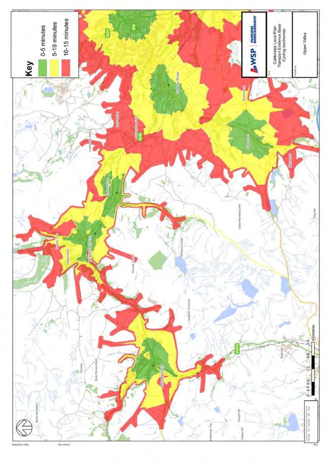
97
98 Appendix C SATURN MODEL
99 APPENDIX C-1 AM PEAK
100
101 APPENDIX C-2 PM PEAK

102
103 APPENDIX C-3 INTER-PEAK

104
105 Appendix D GOOGLE TRAFFIC DATA (AM PEAK)
106 APPENDIX D-1 HALIFAX

107
108 APPENDIX D-2 BRIGHOUSE
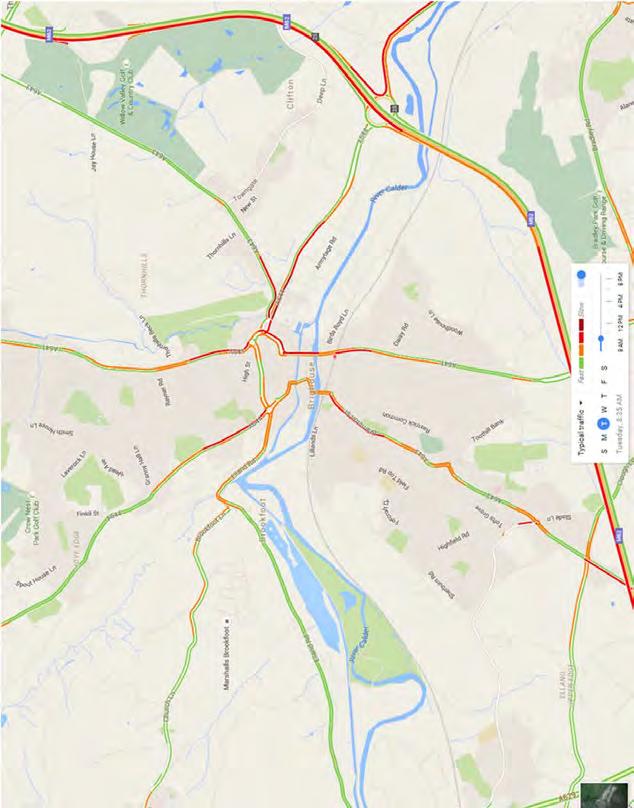
109
110 APPENDIX D-3 ELLAND

111
112 APPENDIX D-4 SOWERBY BRIDGE
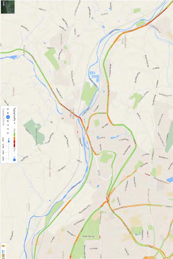
113
114 APPENDIX D-5 NORTHOWRAM AND SHELF

115
116 APPENDIX D-6 UPPER CALDER VALLEY


117


118 Appendix E TRACC PUBLIC TRANSPORT ACCESSIBILITY
119 APPENDIX E-1 CALDERDALE COLLEGE
120
121 APPENDIX E-2 CALDERDALE SECONDARY
122
123 APPENDIX E-3 GPS
124
125 APPENDIX E-4 HOSPITALS
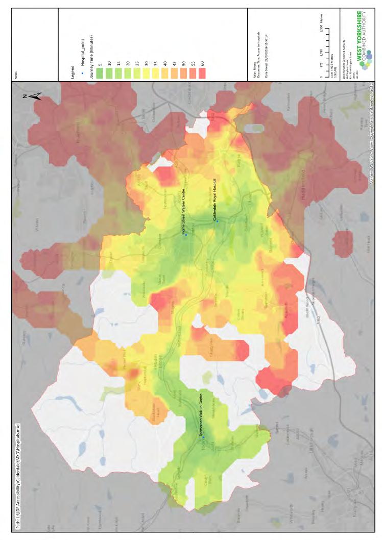
126
127 APPENDIX E-5 JUNIOR INFANT PRIMARY SCHOOLS
128
129 APPENDIX E-6 PRIMARY EMPLOYMENT
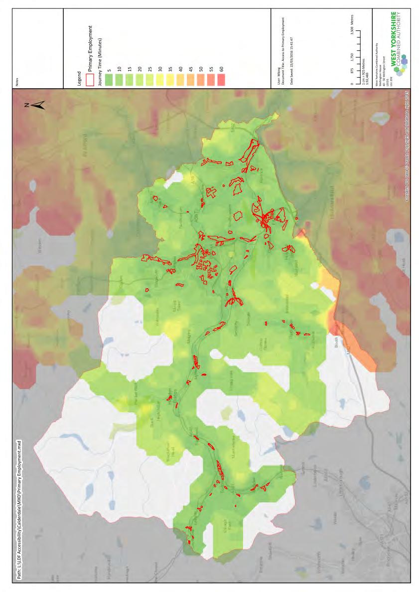
130
East Lancashire Highways and Transport Masterplan East Lancashire Rail Connectivity Study Conditional Output Statement (Appendix 'A' refers)
") Report to the Cabinet Member for Highways and Transport Report submitted by: Director of Corporate Commissioning Date: 1 June 2015 Part I Electoral Divisions affected: All East Lancashire Highways and
Report to the Cabinet Member for Highways and Transport Report submitted by: Director of Corporate Commissioning Date: 1 June 2015 Part I Electoral Divisions affected: All East Lancashire Highways and
Section A: Scheme Summary
 Section A: Scheme Summary Name of Scheme: PMO Scheme Code: Lead Organisation: Senior Responsible Officer: Lead Promoter Contact: Case Officer: North East Calderdale Transformational Programme WYTF-PA4-054
Report of the Strategic Director (Place) to the meeting of Environment and Waste Management Overview & Scrutiny Committee to be held on 28 March 2017.
 to the meeting of Environment and Waste Management Overview & Scrutiny Committee to be held on 28 March 2017.") Report of the Strategic Director (Place) to the meeting of Environment and Waste Management Overview & Scrutiny Committee to be held on 28 March 2017. Subject: AE Bradford District Rail Update. Summary
Report of the Strategic Director (Place) to the meeting of Environment and Waste Management Overview & Scrutiny Committee to be held on 28 March 2017. Subject: AE Bradford District Rail Update. Summary
APPENDIX 8. Leeds Socio-Economic Baseline Report. Report. July Metro and Leeds City Council
 APPENDIX 8 Leeds Socio-Economic Baseline Report Report July 2009 Prepared for: Prepared by: Metro and Leeds City Council Steer Davies Gleave West Riding House 67 Albion Street Leeds LS1 5AA +44 (0)113
5 Rail demand in Western Sydney
 5 Rail demand in Western Sydney About this chapter To better understand where new or enhanced rail services are needed, this chapter presents an overview of the existing and future demand on the rail network
East West Rail Consortium
 East West Rail Consortium EWR Wider Economic Case: Refresh 18 th November 2015 Rupert Dyer Rail Expertise Ltd Rail Expertise Ltd. Tel: 01543 493533 Email: info@railexpertise.co.uk 1 Introduction 1.1 The
Re-opening of the Skipton to Colne Railway Executive Summary
 Re-opening of the to Colne Railway Executive Summary SELRAP SELRAP is the East Lancashire Rail Action Partnership. It was established with the objective of campaigning for the reinstatement of the railway
EAST WEST RAIL EASTERN SECTION. prospectus for growth
 EAST WEST RAIL EASTERN SECTION prospectus for growth September 2018 executive summary The East West Rail Consortium, a partnership of local authorities, rail operators and Network Rail, continues to promote
Public Realm & Landscape
 Town Centre Context Public Realm & Landscape 1. Public realm in the Town Centre varies significantly in quality. Areas of particularly good quality public realm are located around the Minster and outside
Report of the Strategic Director of Place to the meeting of Executive to be held on 11 September 2018
 Report of the Strategic Director of Place to the meeting of Executive to be held on 11 September 2018 Subject: M Arrangements for the establishment of a West Yorkshire Urban Traffic Management Control
BARNSLEY METROPOLITAN BOROUGH COUNCIL
 BARNSLEY METROPOLITAN BOROUGH COUNCIL This matter is a Key Decision within the Council s definition and has been included in the relevant Forward Plan REPORT OF THE EXECUTIVE DIRECTOR OF PLACE TO CABINET
Report to: Greater Cambridge Partnership Joint Assembly 18 January A10 Foxton level crossing bypass and travel hub
 Report to: Greater Cambridge Partnership Joint Assembly 18 January 2018 Lead officer: Chris Tunstall GCP Director of Transport A10 Foxton level crossing bypass and travel hub 1. Purpose 1.1 The list of
2.3 On 27 November, the Department for Transport issued guidance on the use of the powers contained in the Act.
 Director: Dave Pearson, Director of Transport Services Report to: Bradford District Consultation Sub-Committee Date: 22 January 2018 Subject: Information Report 1 Purpose 1.1 Matters of information relating
Response to the London Heathrow Airport Expansion Public Consultation
 Response to the London Heathrow Airport Expansion Public Consultation Summary This report sets out the response to the Heathrow Airport s consultation on airport expansion and airspace change. The consultation
Calderdale MBC. Wards Affected: Town. Economy and Investment Panel: 20 October Halifax Station Gateway Masterplan
 Calderdale MBC Wards Affected: Town Economy and Investment Panel: 20 October 2016 Halifax Station Gateway Masterplan Report of the Acting Director, Economy and Environment 1. Purpose of the Report 1.1
Roundhouse Way Transport Interchange (Part of NATS City Centre Package)
") Roundhouse Way Transport Interchange (Part of NATS City Centre Package) 15/16 16/17 17/18 18/19 19/20 Total TOTAL COST Roundhouse Way Transport Interchange 0.5m 0.5m FUNDING CIL 0.05m 0.05m Growth Deal
Roundhouse Way Transport Interchange (Part of NATS City Centre Package) 15/16 16/17 17/18 18/19 19/20 Total TOTAL COST Roundhouse Way Transport Interchange 0.5m 0.5m FUNDING CIL 0.05m 0.05m Growth Deal
Produced by: Destination Research Sergi Jarques, Director
 Produced by: Destination Research Sergi Jarques, Director Economic Impact of Tourism Epping Forest - 2014 Economic Impact of Tourism Headline Figures Epping Forest - 2014 Total number of trips (day & staying)
Strategic Transport Forum 21 st September 2018
 Strategic Transport Forum 21 st September 2018 Agenda Item 4: Heathrow Airport Expansion: Surface Access Strategy Update Recommendation: It is recommended that the Forum consider the update provided by
Rail Update Station Usage Statistics and Network Rail Performance
 Rail Update Station Usage Statistics and Network Rail Performance Committee Operations Date of meeting 26 January 2018 Date of report 21 December 2017 Report by Senior Director 1. Object of report To update
A140 study and Major Road Network
 A140 study and Major Road Network Executive Summary The Government s new Transport Investment Strategy sets out a new long-term approach for government infrastructure spending. Funding will be targeted
WELLINGTON $422 MILLION $614 MILLION $83 MILLION 22% SPEND $1.9 BILLION
 WELLINGTON WELLINGTON $1.9 BILLION FORECAST TOTAL WELLINGTON INVESTMENT The Wellington region s transport challenges are dominated by the region s concentration of population in the metropolitan cities,
Agenda Item 5: Rail East Midlands Rail Franchise Consultation
 Strategic Transport Forum 15 th September 2017 Agenda Item 5: Rail East Midlands Rail Franchise Consultation Recommendation: It is recommended that the Forum agree (subject to any amendments agreed by
Kilometres. Blacktown. Penrith. Parramatta. Liverpool Bankstown. Campbelltown
 0 5 10 15 20 Kilometres Penrith Blacktown Parramatta Liverpool Bankstown Campbelltown accessibility outcomes Legend Outcomes targeted in Western Sydney are: public transport that is accessible throughout
Borders Railway: What is the impact two years on?
 STAR 2018 Borders Railway: What is the impact two years on? Rachel Thomas, Peter Brett Associates, Scott Leitham, Peter Brett Associates, and Rebecca Rossi, Transport Scotland 1 INTRODUCTION The Borders
TRANSPORT FOR GREATER MANCHESTER COMMITTEE REPORT FOR RESOLUTION
 TRANSPORT FOR GREATER MANCHESTER COMMITTEE REPORT FOR RESOLUTION DATE: 11 November 2011 SUBJECT: REPORT OF: Proposed making of a Quality Partnership Scheme for the A6 corridor between Manchester and Hazel
The case for rail devolution in London. Submission to the London Assembly Transport Committee. June Response.
 Response The case for rail devolution in London Submission to the London Assembly Transport Committee Pedro Abrantes Senior Economist pteg Support Unit Wellington House 40-50 Wellington Street Leeds LS1
Produced by: Destination Research Sergi Jarques, Director
 Produced by: Destination Research Sergi Jarques, Director Economic Impact of Tourism Oxfordshire - 2016 Economic Impact of Tourism Headline Figures Oxfordshire - 2016 number of trips (day & staying) 27,592,106
Wellington $312 $49 $456 OVERVIEW WELLINGTON REGIONAL SUMMARY
 National Land Transport Programme 2015 18 Wellington WELLINGTON REGIONAL SUMMARY OVERVIEW The Wellington region is made up of a number of cities, urban areas and supporting rural hinterland. The city is
Produced by: Destination Research Sergi Jarques, Director
 Produced by: Destination Research Sergi Jarques, Director Economic Impact of Tourism North Norfolk District - 2016 Contents Page Summary Results 2 Contextual analysis 4 Volume of Tourism 7 Staying Visitors
Produced by: Destination Research Sergi Jarques, Director
 Produced by: Destination Research Sergi Jarques, Director Economic Impact of Tourism Norfolk - 2016 Contents Page Summary Results 2 Contextual analysis 4 Volume of Tourism 7 Staying Visitors - Accommodation
Produced by: Destination Research Sergi Jarques, Director
 Produced by: Destination Research Sergi Jarques, Director Economic Impact of Tourism Oxfordshire - 2015 Economic Impact of Tourism Headline Figures Oxfordshire - 2015 Total number of trips (day & staying)
Grow the Economy Briefing note
 Grow the Economy Briefing note Key messages March 2018 The Calderdale economy has shown resilience and consistent growth in the last five years. Since 2012 overall borough performance across a range of
Produced by: Destination Research Sergi Jarques, Director
 Produced by: Destination Research Sergi Jarques, Director Economic Impact of Tourism Norfolk - 2017 Contents Page Summary Results 2 Contextual analysis 4 Volume of Tourism 7 Staying Visitors - Accommodation
3. Coach Supporting Statement
 3. Coach Supporting Statement Content 1. Setting the Scene 2. Vision 3. Coaches and the Shared Priorities 4. Issues 5. Delivery Programme in the first Plan Period 2001/02 2005/06 6. Good Practice 7. Strategy
PREFACE. Service frequency; Hours of service; Service coverage; Passenger loading; Reliability, and Transit vs. auto travel time.
 PREFACE The Florida Department of Transportation (FDOT) has embarked upon a statewide evaluation of transit system performance. The outcome of this evaluation is a benchmark of transit performance that
CONGESTION MONITORING THE NEW ZEALAND EXPERIENCE. By Mike Curran, Manager Strategic Policy, Transit New Zealand
 CONGESTION MONITORING THE NEW ZEALAND EXPERIENCE 26 th Australasian Transport Research Forum Wellington New Zealand 1-3 October 2003 By, Manager Strategic Policy, Transit New Zealand Abstract New Zealand
UK Experience with Bus Restructuring
 UK Experience with Bus Restructuring Outline 1. Background 2. Bus Deregulation outside London 3. London strategy 4. Results to date 5. Edinburgh Case Study 1 Background Prior to mid-1980s, UK local bus
SUMMARY PROOF OF EVIDENCE. Gerald Kells Transport Policy and Campaigns Advisor
 Highways Inquiry Procedure Rules 1994 Doc Ref: OBJ/0125 2 For a local inquiry into: SUMMARY PROOF OF EVIDENCE Gerald Kells Transport Policy and Campaigns Advisor For Friends of the Earth Cymru / Cyfeillion
Appendix 12. HS2/HS1 Connection. Prepared by Christopher Stokes
 Appendix 12 HS2/HS1 Connection Prepared by Christopher Stokes 12 HS2/HS1 CONNECTION Prepared by Christopher Stokes Introduction 12.1 This appendix examines the business case for through services to HS1,
Draft Greater Sydney Region Plan
 Powered by TCPDF (www.tcpdf.org) Draft Greater Sydney Region Plan Submission_id: 31119 Date of Lodgment: 12 Dec 2017 Origin of Submission: Online Organisation name: Serapark Pty Ltd Organisation type:
JOINT CORE STRATEGY FOR BROADLAND, NORWICH AND SOUTH NORFOLK EXAMINATION MATTER 3C EASTON/COSTESSEY
 Matter 3C Easton/Costessey Representor No. 8826 JOINT CORE STRATEGY FOR BROADLAND, NORWICH AND SOUTH NORFOLK EXAMINATION MATTER 3C EASTON/COSTESSEY SUBMISSION ON BEHALF OF TAYLOR WIMPEY DEVELOPMENTS AND
Chapter 12. HS2/HS1 Connection. Prepared by Christopher Stokes
 Chapter 12 HS2/HS1 Connection Prepared by Christopher Stokes 12 HS2/HS1 CONNECTION Prepared by Christopher Stokes 12.1 This chapter relates to the following questions listed by the Committee: 3.1 Business
Major Scheme Business Case Summary Report for Programme Entry
 Paper A Heart of South West Local Transport Board Major Scheme Business Case Summary Report for Programme Entry M5 Junction 25, Taunton July 2016 1 SCHEME SUMMARY Scheme Name M5 Junction 25, Taunton Date
As part of our transport vision, Leeds City Council, working with the West Yorkshire Combined Authority and Leeds Bradford Airport Company, is
 As part of our transport vision, Leeds City Council, working with the West Yorkshire Combined Authority and Leeds Bradford Airport Company, is considering options for improving surface access and connectivity
A TRANSPORT SYSTEM CONNECTING PEOPLE TO PLACES
 THE MAYOR'S VISION FOR TRANSPORT A TRANSPORT SYSTEM CONNECTING PEOPLE TO PLACES VISION We will build a transport system that works for everyone, connecting people to the places they want to go within the
National Passenger Survey Spring putting rail passengers first
 National Passenger Survey putting rail passengers first What is Passenger Focus? Passenger Focus is the independent national rail consumer watchdog. Our mission is to get the best deal for Britain s rail
The Economic Impact of Tourism Brighton & Hove Prepared by: Tourism South East Research Unit 40 Chamberlayne Road Eastleigh Hampshire SO50 5JH
 The Economic Impact of Tourism Brighton & Hove 2013 Prepared by: Tourism South East Research Unit 40 Chamberlayne Road Eastleigh Hampshire SO50 5JH CONTENTS 1. Summary of Results 1 1.1 Introduction 1 1.2
REAUTHORISATION OF THE ALLIANCE BETWEEN AIR NEW ZEALAND AND CATHAY PACIFIC
 Chair Cabinet Economic Growth and Infrastructure Committee Office of the Minister of Transport REAUTHORISATION OF THE ALLIANCE BETWEEN AIR NEW ZEALAND AND CATHAY PACIFIC Proposal 1. I propose that the
Train Stations are not just arrival and departure locations
 Train Stations are not just arrival and departure locations The Railway Study Association Mike Goggin 31 October 2017 Contents Introduction to Steer Davies Gleave The Passenger The Neighbour & Non-Traveller
PERTH AND KINROSS COUNCIL. Housing and Health Committee. 25 May Perth and Kinross Local Housing Strategy
 PERTH AND KINROSS COUNCIL 7 16/234 Housing and Health Committee 25 May 2016 Perth and Kinross Local Housing Strategy 2016-2021 Report by Director (Housing and Social Work) PURPOSE OF REPORT This report
N4 Carrick-on-Shannon to Dromod Road Project. 2.1 Introduction
 Chapter 2 Need for the Scheme 2.1 Introduction The National Primary Route N4, Dublin to Sligo is a strategic corridor from Dublin to the northwest and border counties (See RCSR 101 in Volume 2). The National
Economic Impact of Tourism. Norfolk
 Economic Impact of Tourism Norfolk - 2009 Produced by: East of England Tourism Dettingen House Dettingen Way, Bury St Edmunds Suffolk IP33 3TU Tel. 01284 727480 Contextual analysis Regional Economic Trends
PORTFOLIO: TRANSPORT, PLANNING AND SUSTAINABILITY (COUNCILLOR RAMESH PATEL)
") CYNGOR DINAS CAERDYDD CITY OF CARDIFF COUNCIL CABINET: 15 DECEMBER 2016 CARDIFF WEST TRANSPORT INTERCHANGE REPORT OF DIRECTOR CITY OPERATIONS AGENDA ITEM: 9 PORTFOLIO: TRANSPORT, PLANNING AND SUSTAINABILITY
CYNGOR DINAS CAERDYDD CITY OF CARDIFF COUNCIL CABINET: 15 DECEMBER 2016 CARDIFF WEST TRANSPORT INTERCHANGE REPORT OF DIRECTOR CITY OPERATIONS AGENDA ITEM: 9 PORTFOLIO: TRANSPORT, PLANNING AND SUSTAINABILITY
Gold Coast. Rapid Transit. Chapter twelve Social impact. Chapter content
 Gold Coast Rapid Transit Chapter twelve Social impact Chapter content Social impact assessment process...235 Existing community profile...237 Consultation...238 Social impacts and mitigation strategies...239
Team London Bridge Response to the Department for Transport Consultation on the combined Thameslink, Southern and Great Northern franchise
 Team London Bridge Response to the Department for Transport Consultation on the combined Thameslink, Southern and Great Northern franchise 23 August 2012 Table of Contents 1. Executive Summary 2. Introduction
North Waikato Integrated Growth Management
 North Waikato Integrated Growth Management Programme Business Case Draft Revision C November 2017 Contents 1. Introduction... 10 1.1 Partners and key stakeholders... 11 2. Programme context... 12 2.1 Geographic
Table 1 overleaf summarises the changes in planned growth between the 2016 and 2017 iterations of the plan.
 Addendum to Guildford Borough Proposed Submission Local Plan June 2016 Strategic Highway Assessment Report: High level review of potential of key changes in the Guildford borough Proposed Submission Local
Report Author: Jo Turton, Executive Director for the Environment, Lancashire County Council
 Transport for Lancashire Committee 1 st July 2013 Local Major Transport Scheme Investment Programme Report Author: Jo Turton, Executive Director for the Environment, Lancashire County Council Executive
Visual and Sensory Aspect
 Updated All Wales LANDMAP Statistics 2017 Visual and Sensory Aspect Final Report for Natural Resources Wales February 2018 Tel: 029 2043 7841 Email: sw@whiteconsultants.co.uk Web: www.whiteconsultants.co.uk
The Bus Services Bill and Municipal Bus Companies
 The Bus Services Bill and Municipal Bus Companies Summary Why we need bus services What are municipal bus operators? Network Warrington Being commercial/serving the community Bus Services Bill Value to
The Government s Aviation Strategy Transport for the North (TfN) response
 response") The Government s Aviation Strategy Transport for the North (TfN) response Transport for the North Background Good transport links are a crucial part of a strong economy supporting labour markets and delivering
The Government s Aviation Strategy Transport for the North (TfN) response Transport for the North Background Good transport links are a crucial part of a strong economy supporting labour markets and delivering
Ilkley Parking Review
 Ilkley Parking Review Bradford Metropolitan Borough Council Report July 2017 Our ref: 23073301 Client ref: SD Ilkley Parking Review Bradford Metropolitan Borough Council Report July 2017 Our ref: 23073301
Saighton Camp, Chester. Technical Note: Impact of Boughton Heath S278 Works upon the operation of the Local Highway Network
 Technical Note: Impact of Boughton Heath S278 Works July 2013 SAIGHTON CAMP CHESTER COMMERCIAL ESTATES GROUP TECHNICAL NOTE: IMPACT OF BOUGHTON HEATH S278 WORKS UPON THE OPERATION OF THE LOCAL HIGHWAY
Submission to Infrastructure Victoria s Draft 30-Year Infrastructure Strategy
 Submission to Infrastructure Victoria s Draft 30-Year Infrastructure Strategy 1. Introduction This submission is a response to Infrastructure Victoria s assessment of the need to construct a heavy rail
OBJECTION TO AMENDMENT TO PLANNING SCHEME AND GRANTING OF PLANNING PERMIT
 PLANNING AND ENVIRONMENT ACT 1987 OBJECTION TO AMENDMENT TO PLANNING SCHEME AND GRANTING OF PLANNING PERMIT AMENDMENT C32 APPLICATION 0873/02 Public Transport Users Association Inc. 247-249 Flinders Lane
London Borough of Barnet Traffic & Development Design Team
 London Borough of Barnet Traffic & Development Design Team AERODROME ROAD PEDESTRIAN FACILITY AND BUS STOP INTRODUCTION FEASIBILITY REPORT Job Number: 60668 Doc Ref: S106/12-13/60668 Author: Manoj Kalair
The West of England Partnership is the sub-regional partnership formed by the four councils working together with partners
 Great Western Route Utilisation Strategy Evidence Submission June 2008 Wilder House Wilder Street Bristol BS2 8PH 0117 903 6868 www.westofengland.org 1 The West of England Partnership is the sub-regional
Consultation on Draft Airports National Policy Statement: new runway capacity and infrastructure at airports in the South East of England
 Tony Kershaw Honorary Secretary County Hall Chichester West Sussex PO19 1RQ Telephone 033022 22543 Website: www.gatcom.org.uk If calling ask for Mrs. Paula Street e-mail: secretary@gatcom.org.uk 22 May
Gold Coast: Modelled Future PIA Queensland Awards for Planning Excellence 2014 Nomination under Cutting Edge Research category
 Gold Coast: Modelled Future PIA Queensland Awards for Planning Excellence 2014 Nomination under Cutting Edge Research category Jointly nominated by SGS Economics and Planning and City of Gold Coast August
Interstate 90 and Mercer Island Mobility Study APRIL Commissioned by. Prepared by
 Interstate 90 and Mercer Island Mobility Study APRIL 2017 Commissioned by Prepared by Interstate 90 and Mercer Island Mobility Study Commissioned by: Sound Transit Prepared by: April 2017 Contents Section
Movement Strategy. November On behalf of Barton Oxford LLP
 Movement Strategy November 2014 On behalf of Barton Oxford LLP BARTON PARK, OXFORD. Movement Strategy 17/11/2014 Quality Management Issue/revision Issue 1 Revision 1 Revision 2 Revision 3 Remarks Date
Chapter 8 Route Window NE7 Chadwell Heath station. Transport for London
 Chapter 8 Route Window NE7 Chadwell Heath station Transport CHADWELL HEATH STATION 8 Route Window NE7 Chadwell Heath station Baseline conditions 8.6 This route window lies within the London Boroughs of
CAA Passenger Survey Report 2005
 Economic Regulation Group CAA Passenger Survey Report 2005 Survey of passengers at Aberdeen, Bournemouth, Durham Tees Valley, Edinburgh, Gatwick, Glasgow, Heathrow, Inverness, Leeds Bradford, Luton, Manchester,
transport.gov.scot Borders Railway Year 1 Evaluation
 transport.gov.scot June 2017 CONTENTS 1 Introduction 2 Background 3 Methodological Approach 4 Investment Objectives 5 Visitor Trips 6 Service Quality and Barriers to Use 2 Transport Research Summary The
Proposals for the Harrogate Road / New Line Junction Improvement Scheme. August / September Supported by:
 Proposals for the Harrogate / New Line Junction Improvement Scheme August / September 2016 Supported by: Introduction Key Benefits Proposals are currently being developed for changes to the junction of
SRA FUTURE FARES POLICY
 SRA FUTURE FARES POLICY This response has been prepared by PTEG on behalf of the 7 Passenger Transport Authorities and Executives in England and Scotland. We welcome the publication of the consultation
HEAD OF ECONOMIC PROMOTION AND PLANNING Nathan Spilsted, Senior Planning Officer Tel:
 7. TRAVELLER SITES ALLOCATIONS DOCUMENT REPORT OF: Contact Officer: Wards Affected: Key Decision: Report to: HEAD OF ECONOMIC PROMOTION AND PLANNING Nathan Spilsted, Senior Planning Officer Email: nathan.spilsted@midsussex.gov.uk
Demand and Appraisal Report
 Demand and Appraisal Report HS2 London - West Midlands Report for HS2 Ltd MVA Consultancy, In Association With Mott MacDonald and Atkins April 2012 Document Control Project Title: MVA Project Number: Document
In your area. Stourton to Hunslet LA17. June Introduction. High Speed Two (HS2) is
 is") June 2018 www.hs2.org.uk In your area Stourton to Hunslet LA17 High Speed Two (HS2) is to Leeds M621 HUNSLET A639 STOURTON M621 A61 M1 A63 A639 M1 HS2 Phase 2b to Birmingham the Government s planned new
June 2018 www.hs2.org.uk In your area Stourton to Hunslet LA17 High Speed Two (HS2) is to Leeds M621 HUNSLET A639 STOURTON M621 A61 M1 A63 A639 M1 HS2 Phase 2b to Birmingham the Government s planned new
Guildford Borough Transport Strategy 2017, Topic Paper: Transport, June 2017 (accompanying Local Plan 2017) Local Plan Transport Strategy 2017
 Local Plan Transport Strategy 2017") Guildford Society Transport Group Position Paper August 2017 Based on submissions in response to the June/July 2017 Local Plan consultation including material presented to Drop-in Session 15 July 2017.
Guildford Society Transport Group Position Paper August 2017 Based on submissions in response to the June/July 2017 Local Plan consultation including material presented to Drop-in Session 15 July 2017.
CHRISTCHURCH MOTORWAYS. Project Summary Statement February 2010
 CHRISTCHURCH MOTORWAYS Project Summary Statement February 2010 Table of Contents 1. Purpose of Document 2. Strategic Context 3. Benefits 4. Project Scope and Economics 5. Implementation Plan 1 ROADS OF
This report is PUBLIC [NOT PROTECTIVELY MARKED] Board Meeting. Councillor Roger Lawrence Transport
![This report is PUBLIC [NOT PROTECTIVELY MARKED] Board Meeting. Councillor Roger Lawrence Transport](/thumbs/85/92100595.jpg "This report is PUBLIC [NOT PROTECTIVELY MARKED] Board Meeting. Councillor Roger Lawrence Transport") Agenda Item No. 5.4 Board Meeting Date 17 February 2017 Report title Cabinet Member Portfolio Lead Accountable Managing Director Accountable Employee Report has been considered by West Midlands Bus Alliance
Agenda Item No. 5.4 Board Meeting Date 17 February 2017 Report title Cabinet Member Portfolio Lead Accountable Managing Director Accountable Employee Report has been considered by West Midlands Bus Alliance
Noise Action Plan Summary
 2013-2018 Noise Action Plan Summary Introduction The EU Noise Directive 2002/49/EU and Environmental Noise (Scotland) Regulations 2006 requires airports with over 50,000 movements a year to produce a noise
Regulatory Committee
 Page 1 - Proposed Turning Movement Bans at South Gate Junction, Dorchester Regulatory Committee Date of Meeting 16 March 2017 Officer Subject of Report Executive Summary Andrew Martin Service Director
Commissioned by: Economic Impact of Tourism. Stevenage Results. Produced by: Destination Research
 Commissioned by: Produced by: Destination Research www.destinationresearch.co.uk December 2016 Contents Page Introduction and Contextual Analysis 3 Headline Figures 5 Volume of Tourism 7 Staying Visitors
Economic Impact of Tourism. Hertfordshire Results. Commissioned by: Visit Herts. Produced by:
 Commissioned by: Visit Herts Produced by: Destination Research www.destinationresearch.co.uk December 2016 Contents Page Introduction and Contextual Analysis 3 Headline Figures 5 Volume of Tourism 7 Staying
Chapter 6 Route Window NE5 Seven Kings station. Transport for London
 Chapter 6 Route Window NE5 Seven Kings station Transport SEVEN KINGS STATION 6 Route Window NE5 Seven Kings Station Transport Introduction 6.1 All construction activities in this route window are associated
Llandudno Junction. Regeneration Proposals for the Future. December 2009
 Llandudno Junction Regeneration Proposals for the Future December 2009 Llandudno Junction - Vision Statement 1 Purpose 1.1 The purpose of this document is to describe key priorities to support the regeneration
A303. Sparkford to Ilchester Dualling Scheme Preferred Route Announcement
 A303 Sparkford to Ilchester Dualling Scheme Preferred Route Announcement About this booklet This booklet presents the preferred route for the A303 Sparkford to Ilchester dualling scheme and a summary of
7. CONSULTATION ON THE TRAVELLER SITES ALLOCATIONS DOCUMENT
 7. CONSULTATION ON THE TRAVELLER SITES ALLOCATIONS DOCUMENT REPORT OF: HEAD OF ECONOMIC PROMOTION AND PLANNING Contact Officer: Nathan Spilsted, Senior Planning Officer Email: nathan.splistead@midsussex.gov.uk
South of England north-south connectivity
 South of England north-south connectivity An outline economic case for the inclusion of north-south connectivity improvements to form part of the government s road investment strategy (RIS2) Weston-super-Mare
Performance Criteria for Assessing Airport Expansion Alternatives for the London Region
 Performance Criteria for Assessing Airport Expansion Alternatives for the London Region Jagoda Egeland International Transport Forum at the OECD TRB Annual Meeting 836 - Measuring Aviation System Performance:
Lower Thames Crossing consultation response
 Lower Thames Crossing consultation response Context: This is the response from Campaign for Better Transport to the Department for Transport s consultation Options for a new Lower Thames Crossing. Consultation
STRATEGIC INVESTMENT IN MANCHESTER AIRPORT
 Report To: EXECUTIVE CABINET Date: 7 February 2018 Cabinet Deputy/Reporting Officer: Subject: Report Summary: Cllr Bill Fairfoull Executive Member (Finance & Performance) Tom Wilkinson, Assistant Director
Economic Impact of Tourism. Cambridgeshire 2010 Results
 Economic Impact of Tourism Cambridgeshire 2010 Results Produced by: Tourism South East Research Department 40 Chamberlayne Road, Eastleigh, Hampshire, SO50 5JH sjarques@tourismse.com http://www.tourismsoutheast.com
Regulating Air Transport: Department for Transport consultation on proposals to update the regulatory framework for aviation
 Regulating Air Transport: Department for Transport consultation on proposals to update the regulatory framework for aviation Response from the Aviation Environment Federation 18.3.10 The Aviation Environment
Draft City Centre Transport Proposals
 Draft City Centre Transport Proposals Introduction This draft position paper provides an overview of the current City Centre transport issues, including concepts of the possible future City Centre transport
Disabled Person s and Blind Person s Travel Pass
 DC-016 March 2018 Disabled Person s and Blind Person s Travel Pass Travel Passes for Disabled and Blind People If you are a West Yorkshire resident and have a disability, you may be able to get a Blind
33 Horseferry Road HP20 1UA London SW1P 4DR. Tuesday 10 th October Dear Sir,
 East Midlands Rail Franchise Programme Office Consultation Co-ordinator c/o Buckinghamshire County Council Zone 2/21 County Hall Department for Transport Walton Street Great Minster House Aylesbury 33
TAYplan SDPA. Main Issues Report. Options for Scotland s s SusTAYnable Region (Strategic Development Planning Authority)
") TAYplan SDPA (Strategic Development Planning Authority) Main Issues Report Options for Scotland s s SusTAYnable Region 2012-2032 2032 Content 1. The Development Plan System in Scotland 2. TAYplan in Context
TAYplan SDPA (Strategic Development Planning Authority) Main Issues Report Options for Scotland s s SusTAYnable Region 2012-2032 2032 Content 1. The Development Plan System in Scotland 2. TAYplan in Context