Communication in the West and the Transcontinental Railroad!!!
|
|
|
- Cameron Hubbard
- 5 years ago
- Views:
Transcription

1 Communication in the West and the Transcontinental Railroad!!!
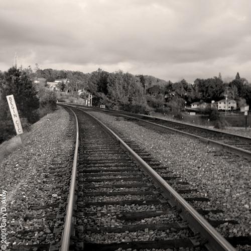
2 What was communication like during Westward Expansion?
3 If people wanted to get letters from the West back to the East, the fastest way was the Express. The Pony Express was able to deliver a letter in days by using a system of horse riders who would ride for a short time and pass the letters off to each other!

4 Better technology comes along A new technology came along that made it much faster to get messages back and forth between the East and West coasts. This new technology was called a machine. It used as a way to communicate. It was a system on lines, dots, and dashes that meant different letters.
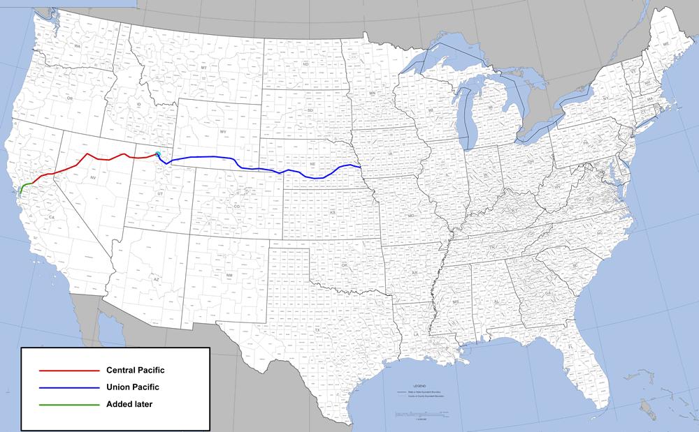
5 The telegraph moved messages quickly, but we needed a way to move people quickly
6
7 Break it down Transcontinental Trans=across Continental=the USA
8

9 The Transcontinental Railroad It was 1,775 miles from Omaha, NE to Sacramento, CA. (Page 130 in textbook)

10 The Transcontinental Railroad Railroads had already transformed life in the East, but at the end of the Civil War railroad tracks still stopped at the Missouri River. For a quarter of a century, men had dreamed of building a line from coast to coast. Now they would attempt to lay 1,775 miles of track from Omaha to Sacramento. Slide #1

11 The Transcontinental Railroad A path would have to be cut through mountains higher than any railroad-builder had ever faced; span deserts where there was no water anywhere; and cross treeless prairies where anxious and defiant Indians would resist their passage.

12 The Transcontinental Railroad In 1862, Congress gave charters to two companies to build these tracks. The Central Pacific was to push eastward from Sacramento, over the Sierra Nevada mountains. The Union Pacific was to start from Omaha Nebraska, cross the great plains and cut through the Rockies.

13 The Transcontinental Railroad The Union Pacific and Central Pacific were soon locked in a race to see who could lay the most track -- and therefore get the most land and money. Somewhere in the West -- no one knew exactly where -- the two lines were supposed to meet. Slide #5
14 The Transcontinental Railroad In 1862, Congress loaned the Central Pacific and Union Pacific Railroads $16,000 per mile of level track and $48,000 per mile of mountain track. Congress also promised each company 6,400 acres of federal land for every mile of track it laid. Slide #13

15 The Transcontinental Railroad In 1865, Crocker, in charge of construction, found a solution to their work force problem. Besides hiring Irish immigrants who worked for low pay, the Central pacific Railroad employed over 10,000 immigrants. Slide #14

16 The Transcontinental Railroad In 1866, the CPR had 44 blizzards while trying to tunnel through the Sierras. In 1869, the CPR laid 360 miles of track. On April 28, 1869, the CPR crew set a record of laying 10 miles in twelve hours. Slide #15
17 Negative Aspects of the Transcontinental Railroad When the railroads crossed the plains they affected the herds of that had freely wandered there. The RR tracks were usually trampled on by the herds.
18 Disadvantages of the Transcontinental Railroad The Railroad owners hired to shoot them so they wouldn t mess up the railroad. Soon the population of bison and buffalo began to. The Native Americans were very, very unhappy because they relied on the buffalo to live! Aside from the buffalo problem, the smoke from the coal engines began to the air.
19 The Advantages of the Transcontinental Railroad Traveling by RR was so many people used it. If they couldn t afford the train, they still traveled by covered wagon. The RR attracted many new to the US! The settlers moved West to try to make money by farming. The RR provided a way for getting their to the markets.
20 More Advantages of the Transcontinental Railroad The RR transported agricultural products to processing centers and helped major industries such as flour milling and meat processing develop in large cities like Chicago.
21 The Impact of the Railroads The railroads spurred economic growth. Steelworkers turned millions of tons of iron into steel for tracks and engines. Lumberjacks supplied wood for railroad ties. Miners dug coal to fuel the engines. The railroads opened every corner of the country to settlement and growth.

22 The Transcontinental Railroad Finally, on May 10, 1869, The CPR and UPR met at, Utah. The presidents of both railroads, Stanford and Durant, swung at the last gold spike. Slide #16
23 Here are your notes: The Pony Express and Telegraph were helpful for getting news across the country, but the Transcontinental Railroad was built to get people across the country. In 1862, Lincoln decided to build the RR. Two Companies started building the RR on each side of the country. They were racing to get the most land and money from the government. The RR companies had African-Americans and Immigrants work for them. People were able to make the trip on a train in only 3
24 Let s create a chart of all of the advantages and disadvantages the RR brought. Advantages Quick Travel Time Move Crops Able to Make more $ More immigration Transfer Supplies Cheap Disadvantages If the track broke, the train could crash Killed Buffalo Pollution
25 What was it like??? Turn to page 129 in your SS book! We are going to become the picture and you will be interviewed as if you are the people in the picture!
The Transcontinental Railroad
 Color Coded Notes Words in Red: Copy down exactly (word for word) from the slide. Words in Blue: Summarize in your own words. Words in Black: No need to write them down, just listen carefully to Mr. Sanders
Preparing for Writing Performance Tasks: Readying Students for Success in Writing and State Tests
 Preparing for Writing Performance Tasks: Readying Students for Success in Writing and State Tests "If students are to make knowledge their own, they must struggle with the details, wrestle with the facts,
Section 1: Vocabulary. Be able to determine if the word in bold is used correctly in a sentence.
 Section 1: Vocabulary. Be able to determine if the word in bold is used correctly in a sentence. Hardships: difficult conditions or situations that cause discomfort and/or suffering Pioneers: the people
Pony Express. https://www.youtube.com/watch?v=y1r- GeEd95c
 Pony Express https://www.youtube.com/watch?v=y1r- GeEd95c RIDERS Most riders were around 20 years of age Youngest rider was 11 Oldest rider was mid-40s Many riders were orphans Riders usually weighed around
U.S. History Mr. Boothby 12/14/2017
 U.S. History Mr. Boothby 12/14/2017 Target Chapter 24: Industry Comes of AGE PT1 THE IRON HORSE/ PROMONTORY POINT 1869 and the GOLDEN SPIKE! DID YOU DROP OFF YOUR BLUE AND THE GREY FOR 100 PTS??? http://www.apnotes.net/notes-12e/ch24-12e.html
Overland Stagecoach Service through Tucson If it weren t for stagecoaches, Tucson wouldn t have developed to be the town we see today!
 Ring s Reflections by Bob Ring Overland Stagecoach Service through Tucson 1857-1880 If it weren t for stagecoaches, Tucson wouldn t have developed to be the town we see today! Let s set the stage (sorry).
Morrill Act. frontier. transcontinental railroad. boomtowns reservations. sodbusters. Homestead Act deflation. cattle drive
 Vocabulary 17: End of the Frontier Cut out each picture and paste into the notebook on the left side of the page. Next to each picture, define the term in seven words or less. Words followed by an asterisk
The Highlights of Homeschooling History Literature Unit Study. Oregon Trail. Sample file. Created by Teresa Ives Lilly Sold by
 The Highlights of Homeschooling History Literature Unit Study Oregon Trail Created by Teresa Ives Lilly Sold by www.hshighlights.com INTRODUCTION This history/literature study guide is created to use in
STEEL RIBBON OF MAKING TRACKS FEATURE STORY. The railway helped to make Canada a country, but along the way there were winners and losers, shady
 FEATURE STORY RIBBON OF STEEL The railway helped to make Canada a country, but along the way there were winners and losers, shady deals and amazing achievements The first true railway in Canada was the
Transportation. By: Matthew Kikkert
 Transportation By: Matthew Kikkert Early Transportation Dirt roads began to connect major cities in the early 1700s, but conditions were very poor and dangerous. Taverns sprung up on these roads and were
Warm Up Use complete sentences
 Warm Up Use complete sentences What do you think are 3 differences between the Northern US and the Southern US that caused the Civil War? (asking what you think so there are no wrong answers except silly
A History of West Chicago
 A History of West Chicago The Prairie Prairie Inhabitants Winfield Mounds Dickson Mounds, near Lewistown, in southern Illinois. An example of what Native burial mounds look like. First Permanent Settlers
Lewis & Clark Return Home
 Lewis & Clark Return Home On March 23, 1806, Meriwether Lewis, William Clark, and their team started for home. At first they took the same path. But after they crossed the Rocky Mountains, the group split
CK Ranch Sublette County, Wyoming
 CK Ranch Sublette County, Wyoming 1 Since originally homesteaded in the late me of the finest recreational hunting and e ribbon trout fishing, bordering 5 miles of on request. 2 The CK Ranch is located
FRONTIER TRAILS Tour groups cruising through the
 on location: midwest randy mink NEBRASKA S FRONTIER TRAILS Tour groups cruising through the heart of Nebraska don t have to stray far from the superhighway to get a taste of early life on the prairie.
THE USA. The capital of USA is Washington D.C., in the District of Columbia.
 THE USA The United States of America is the richest and one of the biggest countries in the world. It has a population of about 295 million people. It is divided into 50 states; two of them, Alaska and
Welcome to the Midwest!
 Welcome to the Midwest! Why do we call the Midwest "America's Heartland"? 5 9 7 4 2 Farm State 6 8 1 St. Louis 3 St. Louis, Missouri "Gateway to the West" Frontier: the beginning of unexplored land Pioneers:
Lesson 1: Land and Climate of the West Land and Water of the West 1. There are 13 states in the West, divided into 3 regions a. Southwest: Nevada,
 Lesson 1: Land and Climate of the West Land and Water of the West 1. There are 13 states in the West, divided into 3 regions a. Southwest: Nevada, Utah, Arizona, New Mexico b. Mountain States: Wyoming,
The Tacoma Star of Destiny
 The Tacoma Star of Destiny The Tacoma Star of Destiny is an advertising tool that was developed early in the 20th century touting all the advantages of Tacoma, WA. The following is the list of the manufacturers,
Geography: Unit 2. Map. Rivers. Major Physical Features. Slide 1. Slide 2. Slide 3. Slide 4. North America United States and Canada.
 Mississippi River Slide 1 Slide 2 Slide 3 Slide 4 Geography: Unit 2 North America United States Map Major Physical Features Mountain Ranges Brooks Range Mackenzie Mountains Coast Mountains Cascades Sierra
Notice of Copyright. Citing Resources from the Western History Collections
 Notice of Copyright Published and unpublished materials may be protected by Copyright Law (Title 17, U.S. Code). Any copies of published and unpublished materials provided by the Western History Collections
This Is the. W e s t
 This Is the W e s t This Is the W e s t Copyright by Harcourt, Inc. All rights reserved. No part of this publication may be reproduced or transmitted in any form or by any means, electronic or mechanical,
Economy 3. This region s economy was based on agriculture. 4. This region produced items such as textiles, iron, and ships in great quantities. For th
 Geography 1. This region has a climate of warm summers and snowy cold winters. 2. This region has a climate that is generally warm and sunny, with long, hot, humid summers, and mild winters, and heavy
Human Geography of Canada
 Human Geography of Canada History and Government of Canada Like the United States, people migrated across Beringia into Canada, these people were the ancestors of the Inuit (Eskimos) 16 th and 17 th centuries,
Inquiry: Was It Destiny To Move West? Supporting Question 2: What new technologies influenced westward expansion?
 Inquiry: Was It Destiny To Move West? Supporting Question 2: What new technologies influenced westward expansion? Supporting Question 2: Directions: (1) Keep all papers organized and back in order after
Banff: Canada's First National Park By Eleanor Luxton
 Banff: Canada's First National Park By Eleanor Luxton If you are looking for a ebook by Eleanor Luxton Banff: Canada's First National Park in pdf form, in that case you come on to correct site. We presented
LOCATION, CLIMATE, AND NATURAL RESOURCES OF MEXICO
 SS6G3 The student will explain the impact of location, climate, distribution of natural resources, and population distribution on Latin America and the Caribbean. a. Compare how the location, climate,
In the 1860s, with a movement to
 Trains Railway crew on hand car, 1888. In the 1860s, with a movement to push for Canadian independence gaining ground, the British government passed legislation establishing the Dominion of Canada. At
Geography: Unit 2. Map. Major Physical Features. Rivers. Mississippi River Missouri River Ohio River Rio Grande. Mackenzie. Colorado River Green River
 1 2 3 4 Geography: Unit 2 North America United States and Canada Map Major Physical Features Mountain Ranges Brooks Range Mackenzie Mountains Coast Mountains Cascades Sierra Nevada Rocky Mountains Appalachian
MEEK tart'
 MEEK tart' Post Card Nebraska is one of the nation's leading stock raising areas. It is famous for dairy products. Corn, grain, hay and sugar beets grow in abundance. Industrial activity has rapidly developed.
THE ROCK ISLAND EXHIBIT AT THE WORLD'S FAIR IS LOCATED IN THE TRAVEL AND TRANSPORT BUILDING
 AT THE WORLD'S FAIR THE ROCK ISLAND EXHIBIT AT THE WORLD'S FAIR IS LOCATED IN THE TRAVEL AND TRANSPORT BUILDING THE ROMANCE OF A RAILROAD On the east wall of the Rock Island Theater at the World's Fair
Geography Unit: North America Section: Physical Characteristics and Systems of North America. Tutorial: Regions of North America
 Geography Unit: North America Section: Physical Characteristics and Systems of North America Tutorial: Regions of North America Regions of North America Welcome to the tutorial about the regions of North
DOWNLOAD OR READ : USA CALIFORNIA NEVADA NATIONAL GEOGRAPHIC ADVENTURE TRAVEL MAP PDF EBOOK EPUB MOBI
 DOWNLOAD OR READ : USA CALIFORNIA NEVADA NATIONAL GEOGRAPHIC ADVENTURE TRAVEL MAP PDF EBOOK EPUB MOBI Page 1 Page 2 usa california nevada national geographic adventure travel map usa california nevada
Journey to Pikes Peak
 Parent s Guide Journey to Pikes Peak P l e a s e D o N o t R e m o v e T h i s C o p y Dear Parents, We are so glad you are here thanks for visiting Journey to Pikes Peak! This interactive children s gallery
Ancient Egypt. Life Along the Nile River
 Ancient Egypt Life Along the Nile River 2018 Geography How Does Geography affect the way that people live? Geography- Where in the World? You are Here Streetsboro, Ohio United States of America Geography-
Curriculum Pacing Guide Grade/Course 5 Th Grade Geography Grading Period 1 st Nine Weeks
 2013-2014 Curriculum Pacing Guide Grade/Course 5 Th Grade Grading Period 1 st Nine Weeks Time Frame Unit/ photographs, pictures, and tables to Locate and identify: Continents and Oceans -North America
THE ROCK ISLAND EXHIBIT AT THE WORLD'S FAIR IS LOCATED IN THE TRAVEL AND TRANSPORT BUILDING THE ROMANCE OF A RAILROAD
 AT THE WORLDS FAIR 044 I N..0-311111S,1- THE ROCK ISLAND EXHIBIT AT THE WORLD'S FAIR IS LOCATED IN THE TRAVEL AND TRANSPORT BUILDING THE ROMANCE OF A RAILROAD On the east wall of the Rock Island Theater
RAILROAD THE BRISTOL. they thought, would be a better way to ship their lumber and produce to markets. It
 THE BRISTOL RAILROAD By GREG PAlIL Before there were railroads it was hard to travel in Vermont. Roads were narrow, rough, steep, and often muddy. Most people walked or rode horses. If they had heavy loads
Utah Studies DOMINGUEZ AND ESCALANTE
 Utah Studies THE WORLD IN THE 1400 S In the 1400 s merchants in Europe wanted to buy and sell goods with people in faraway places. Some of the reasons for this desire to trade with the world were: the
Land Distribution. Land Purchases. 14 The Nature of Settlement: Post-Revolution to the Civil War Changing Shape of New York
 14 The Nature of Settlement: Post-Revolution to the Civil War 1780-1865 Prof. Anthony Grande Geography Dept. Hunter College-CUNY Spring 2018 Settlement Sequence: State of New York Revolutionary War ends
Caboose Ride March 22, 2009
 Caboose Ride March 22, 2009 Run By at Restored Dearborn Tower Photo Frank Kammer The Cincinnati Chapter National Railway Society sponsored a caboose on the Banta Rails Caboose Ride that was operated on
A Historical Timeline of Cedar Falls
 A Historical Timeline of Cedar Falls 1700-1750 The Meskwaki (Fox), after having been forced out of their former homes further east, move into the area by 1750. They are allied with the Sauk through language
Laura Ingalls Wilder: A Pioneer s Life
 Laura Ingalls Wilder: A Pioneer s Life A Reading A Z Level S Leveled Book Word Count: 1,077 LEVELED BOOK S Laura Ingalls Wilder: A Pioneer s Life S V Y Written by Katherine Follett Visit www.readinga-z.com
Redesigning The Waterfront
 San Francisco Maritime National Park Service U.S. Department of the Interior National Historical Park California Redesigning The Waterfront A Self-Guided Walking Tour Then & Black Point Cove, ca. 1910.
Location, Climate, & Natural Resources. Where People Live & How They Trade
 Location, Climate, & Natural Resources Where People Live & How They Trade Standards SS6G13 The student will explain the impact of location, climate, distribution of natural resources, and population distribution
1. What was the length of the original National Road? 2. Where and when did the construction of the National Road begin?
 THE NATIONAL ROAD The Historic National Road is a landmark representing the beginning and progress of the United States of America. The original National Road was 800 miles long beginning in Cumberland,
TOWERBUTTE. Lewis and Clark s. >> By Jerry Penry, LS
 4.95 Lewis and Clark s TOWERBUTTE >> By Jerry Penry, LS Have you ever felt like you are standing on hallowed ground, knowing that some very important surveyors had previously occupied that same location?
Historic Trails Research. Lewis and Clark Landmark Document
 Historic Trails Research Lewis and Clark Landmark Document Lewis and Party Crossing the Clearwater Tributary of the Big Blackfoot River 1806-07-05(1)L (Clearwater Crossing) May 29, 2015 Revised: May 31,
V IDEO SCRIPT. TITLE: Rails And Other Roads. PREPARED FOR: Dakota Pathways: A History. WRITER: Paul Higbee. PRODUCER: Jim Sprecher
 V IDEO SCRIPT TITLE: Rails And Other Roads PREPARED FOR: Dakota Pathways: A History WRITER: Paul Higbee PRODUCER: Jim Sprecher DRAFT: Final with shot # s 1 SCRIPT NUMBER: 1 DATE: February 25, 2003 Approved
Unit 11: Travel and Trade
 Unit 11: Travel and Trade Today Due: Current Events Article Assignment Quiz: Unit 10 (Value of Land) In class: Unit 11 (Travel and Trade) HW: wkbk 97-102, study for quiz 11, read Unit 12 (155-166) Lesson
4th Grade Third 9 Weeks Test
 4th Grade Third 9 Weeks Test Multiple Choice Identify the choice that best completes the statement or answers the question. 1 A waterway for ships that is dug across land is called a. A port C river B
STANDARDS: Brain Wrinkles
 STANDARDS: SS6G3 The student will explain the impact of location, climate, distribution of natural resources, and population distribution on Latin America and the Caribbean. a. Compare how the location,
LANDER COUNTY RAIL ASSESSMENT NOVEMBER 2006
 of hydrologic features. A substantial proportion of the land between and north of the railroad tracks contain wetlands, as identified by the US Fish and Wildlife Service National Wetlands Inventory (NWI).
THE GREAT CAMEL EXPERIMENT
 THEGREATCAMELEXPERIMENT I.CONTEXT OfalltheimmigrantswhobecameTexansuponarrivinginoldIndianola German, Czech,Polishandmore perhapsnoneweremoreexoticthantheseventy fivethat cameashorein1856and1857fromalgeria,tunisia,egyptandturkey.butthese
Match the names below with their locations on the map by writing the correct letter in the blank.
 P r e v i e w Match the names below with their locations on the map by writing the correct letter in the blank. Physical Features of Canada 60ºN 70ºN 80ºN A R C T I C O C E A N 130ºW 120ºW 110ºW 90ºW 70ºW
Maggie s Weekly Activity Pack!
 Maggie s Weekly Activity Pack! Name Date Remembering A Great Adventure The Journey of Lewis and Clark It has been two hundred years since Lewis and Clark started their journey across America. In February
(Elie fab a f a ratlfnau plah'4atnvr>
 (Elie fab a f a ratlfnau plah'4atnvr> I THE JOB OF A RAILWAY PLATE LAYER When I was 16,1 signed on for five years training as an apprentice at Eastleigh Wagon Works. That ended in 1925 and I had to look
Mankato s Transportation Heritage
 Mankato s Transportation Heritage City of Mankato Mankato Heritage Preservation Commission May 11, 2017 1. Union Depot, 112 S. Riverfront Drive, c. 1896. The railroads were Mankato s dominant transportation
The Lost Settlement of Roanoke
 Name: Date: The Lost Settlement of Roanoke Inthe1500s,Spainwasapowerful nation.itsshipssailedtothespanish coloniesintheamericasandbrought richesbacktospain. SirWalterRaleigh,aseacaptainandsoldier,wasafriendofQueenElizabethI.
The Natchez Trace The DAR and its Tishomingo County Connection
 The Natchez Trace The DAR and its Tishomingo County Connection Presented By Cindy Whirley Nelson, Chapter Regent, 2006-2008, Chief Tishomingo Chapter DAR Since the time pre-historic tribes roamed the hills
California The Golden State
 California The Golden State California, constituent state of the United States of America. It was admitted as the 31st state of the union on September 9, 1850, and by the early 1960s it was the most populous
Swing-out Van Key Bench
 Swing-out Van Key Bench Eugene E Hansen Feb 2006 In this article we will describe how we made a swing-out bench with key machine mounts and key storage cabinets on a Ford Van F350 (one ton). To start with
Chapter 10 Sampo and Elmo, The Finnish Towns and Mines (1909)
") Chapter 10 Sampo and Elmo, The Finnish Towns and Mines (1909) The Sampo Coal Company constructed the town of Sampo in 1908. It started mine development efforts that same year on an eight-foot vein of coal
Chapter 10 Sampo and Elmo, The Finnish Towns and Mines (1909) The Sampo Coal Company constructed the town of Sampo in 1908. It started mine development efforts that same year on an eight-foot vein of coal
Lost Colony of Roanoke
 Lost Colony of Roanoke Lesson Number: 3 Title: The Lost Colony of Roanoke Grade Level: 5 th Time: 50-60 minutes Materials: Per Student: Roanoke: The Lost Colony short story Roanoke Theories worksheet Evidence
Trail Boss: Rich Bugarin Home # Cell#
 Henness Pass Road Hi-Landers October 2013 Club Run Trail Boss: Rich Bugarin Home # 916-771-3359 Cell# 916-300-3192 E-Mail: rbugarin@hi-landers.com Meet at the Grass Valley Lumber Jack Restraint at 9:00am
MS077 Southern Pacific Railroad Records Legal Department-Corporate Files (LCP) Inventory Compiled by Marsha Labodda
 Inventory Compiled by Marsha Labodda") MS077 Southern Pacific Railroad Records Legal Department-Corporate Files (LCP) Inventory Compiled by Marsha Labodda Box # File Folder # Description Dates LCP-1 Contains Certificate of Incorporation and
MS077 Southern Pacific Railroad Records Legal Department-Corporate Files (LCP) Inventory Compiled by Marsha Labodda Box # File Folder # Description Dates LCP-1 Contains Certificate of Incorporation and
Courtland Arizona. Railroads
 Courtland Arizona Railroads Glenn Snow June 2009 Copyright 2009 Glenn Snow GSnow@GleesonArizona.com Cover photograph: railroad spike, Southern Pacific track bed, Courtland Arizona. Railroads made the settlement
Building Canada. Every year on July 1, Canada celebrates its birthday. On CHAPTER 8
 CHAPTER 8 Building Canada Every year on July 1, Canada celebrates its birthday. On Parliament Hill in Ottawa, there is a concert and a huge fireworks display. Why July 1? On that day in 1867, the country
The Newsletter of the Alaska Live Steamers Jan. 2016
 The Newsletter of the Alaska Live Steamers Jan. 2016 Zach Barnes operating Lutz Braun s Steam Engine July 11 2015 In This Issue Presidents Message: Page 2 Littlest Hobo: Page 3 Meeting Notice: Page 3 Pendergrass
MAIN LINE GRAND CANYON MODEL RAILROADERS. JULY, 2013 Volume 22 Number 7. PRESIDENT S MESSAGE By John Draftz CALENDAR
 GRAND CANYON MODEL RAILROADERS MAIN LINE JULY, 2013 Volume 22 Number 7 PRESIDENT S MESSAGE By John Draftz The theme for our July meeting is Skill at kit bashing, scratch building and repainting - AKA what
Brain Wrinkles. Location, Climate, & Natural Resources of. Where People Live & How They Trade
 Location, Climate, & Natural Resources of Where People Live & How They Trade It s south of the US, east of the Pacific Ocean, and west of the Gulf of Mexico & Caribbean Sea. It s great that it s located
Murrieta Valley Historical Society Newsletter
 Murrieta Valley Historical Society Newsletter Volume 3. Issue 1. It is our mission to identify, preserve and promote the historic legacy of the Murrieta Valley and to educate the public about its historical
Fool's Gold. Jeffrey Dean Langham
 Fool's Gold by Jeffrey Dean Langham Copyright (c) 2013 This screenplaymay not be used or reproduced without the express written permission of the author. j_langham@hotmail.com FADE IN: EXT. CINDY'S BAR
Visit to METSO Alwar (22Mar.2014) A Brief Review
 A Brief Review") Visit to METSO Alwar (22Mar.2014) A Brief Review The Indian Institute of Metals Delhi Chapter regularly organizes visits to eminent industries in and around NCR, for benefit of its members. In this series,
Visit to METSO Alwar (22Mar.2014) A Brief Review The Indian Institute of Metals Delhi Chapter regularly organizes visits to eminent industries in and around NCR, for benefit of its members. In this series,
GEOGRAPHY OF THE UNITED STATES & CANADA. By Brett Lucas
 GEOGRAPHY OF THE UNITED STATES & CANADA By Brett Lucas THE CALIFORNIA REGION Setting the Boundaries What states and provinces are part of the region? Parts of CA and NV. What regions does it border? N.
ETV ENDOWMENT SOUTH DAKOTA GREAT FACES AND GREAT PLACES PATRICK
 SOUTH DAKOTA WITH THE ETV ENDOWMENT AND PATRICK MCMILLAN ETV ENDOWMENT SOUTH DAKOTA with PATRICK McMILLAN Day One: Wednesday-June 7, 2017: Arrivals in Rapid City, South Dakota. Arrive in your gateway city
Interview with Walter C. Robbins ID0005 [Sr] 20 September at his home Transcribed by Walter C. Robbins, Jr. ID0001 [Jr] 20 September 2005
![Interview with Walter C. Robbins ID0005 [Sr] 20 September at his home Transcribed by Walter C. Robbins, Jr. ID0001 [Jr] 20 September 2005](/thumbs/96/128003156.jpg "Interview with Walter C. Robbins ID0005 [Sr] 20 September at his home Transcribed by Walter C. Robbins, Jr. ID0001 [Jr] 20 September 2005") Interview with Walter C. Robbins ID0005 [Sr] 20 September 2005- at his home Transcribed by Walter C. Robbins, Jr. ID0001 [Jr] 20 September 2005 Jr - On the records that I have it says that you worked as
Interview with Walter C. Robbins ID0005 [Sr] 20 September 2005- at his home Transcribed by Walter C. Robbins, Jr. ID0001 [Jr] 20 September 2005 Jr - On the records that I have it says that you worked as
HISTORIC AMERICAN ENGINEERING RECORD COVE CREEK SPILLWAY BRIDGE. HAER No. AR-83
 HISTORIC AMERICAN ENGINEERING RECORD COVE CREEK SPILLWAY BRIDGE LOCATION: Spanning Cove Creek Spillway at State Highway 309 (formerly Paris-Mt. Magazine Road), Corley vicinity, Logan County, Arkansas UTM:
ARKANSAS HISTORIC PRESERVATION PROGRAM. An agency of the Department of Arkansas Heritage
 ARKANSAS HISTORIC PRESERVATION PROGRAM An agency of the Department of Arkansas Heritage Treasure is hidden all over Arkansas, right in our own backyards. We need two things to find it: knowledge and exploration.
Measuring Productivity for Car Booking Solutions
 Measuring Productivity for Car Booking Solutions Value Creation Study Rebecca Bartlett 20th January 2014 Table of Contents Executive Summary Introduction Method Productivity Analysis Scenario 1 Scenario
An introduction to travel & transport with a focus on canals and waterways.
 Teacher guidance notes page 1 Overview of the pack An introduction to travel & transport with a focus on canals and waterways. Key Stage 2 National Curriculum links Geography describe and understand key
Census Affects Children in Poverty by Professors Donald Hernandez and Nancy Denton State University of New York, Albany
 Phone: (301) 457-9900 4700 Silver Hill Road, Suite 1250-3, Suitland, MD 20746 Fax: (301) 457-9901 Census Affects in Poverty by Professors Donald Hernandez and Nancy Denton State University of New York,
Fort Ticonderoga Carillon Battlefield Walking Trail Guide
 Fort Ticonderoga Carillon Battlefield Walking Trail Guide Copyright Fort Ticonderoga. Photo Credit Carl Heilman II Length: Approximately 1¾ mile Welcome to Fort Ticonderoga s Walking Trail Blue markers
Weekly Disaster Stats Update
 Weekly Disaster Stats Update The Weekly Disaster Stats Update is published every week on Tuesday. The product is meant to provide a snapshot of major disaster statistics throughout the calendar year to-date,
Flying W Guest Ranch. Oklahoma - Beckham County - Elk City
 Flying W Guest Ranch Oklahoma - Beckham County - Elk City 2 Flying W Guest Ranch is a well-known guest ranch in a historic location about 90 miles west of Oklahoma City near Elk City, Oklahoma. Situated
Letter Assessment. (date) Dear, In 1864, Then in 1866, In 1867, As it happened in 1868, Then in 1877, The bust came in.
 Dear, In 1864, Then in 1866, In 1867, As it happened in 1868, Then in 1877, The bust came in.") Letter Assessment (date) Dear, In 1864, Then in 1866, In 1867, As it happened in 1868, Then in 1877, The bust came in. Your friend, The Birth of a City and Railroad in the Rocky Mountains Modified for
Letter Assessment (date) Dear, In 1864, Then in 1866, In 1867, As it happened in 1868, Then in 1877, The bust came in. Your friend, The Birth of a City and Railroad in the Rocky Mountains Modified for
Mrs. Reifsnyder World Geography. Unit 8: Latin America Study Guide SOLs Addressed: WG. 1c, 2b, 3c, 4, 10b/c
 Mrs. Reifsnyder World Geography Unit 8: Latin America Study Guide SOLs Addressed: WG. 1c, 2b, 3c, 4, 10b/c Essential Questions: - In what ways do physical, economic, and cultural characteristics influence
Steamboats On Okanagan Lake Okanagan History Vignette
 Photo courtesy of Kelowna Museum Steamboats On Okanagan Lake Okanagan History Vignette 33 Okanagan men going off to war S.S. Sicamous departs from Okanagan Landing during World War I Photo courtesy Kelowna
The Windrush. Page 1 of 2. visit twinkl.com
 HMT Empire Windrush began sailing in 1930. It was originally used as a cruise ship and passenger liner. However, during the Second World War, she was used as a troopship. At first, she was used to transport
satspapers.org CONTENTS Going Underground 3 Small tunnels 4 Getting bigger... 6 The biggest tunnels 8 Down the Mine 10
 CONTENTS Going Underground 3 Small tunnels 4 Getting bigger... 6 The biggest tunnels 8 Down the Mine 10 2 Going Underground Have you ever thought about what is going on underneath you? Under your feet,
Panama Adventure - 8 Days & 7 Nights
 One amazing quality that makes Panama so unique is that from one location in Panama City travelers can enjoy so much of this beautiful country and its culture and nature without having to change hotels.
ALBERTA S GRASSLANDS IN CONTEXT
 ALBERTA S GRASSLANDS IN CONTEXT GLOBAL GRASSLANDS 1 Temperate grasslands, located north of the Tropic of Cancer and south of the Tropic of Capricorn, are one of the world s great terrestrial biomes 2.
National parks WRITING
 National parks WRITING Content National parks were created to preserve natural habitats and allow people to visit and appreciate the natural beauty. Learning Outcomes Read about the purpose and characteristics
Unit 5: Selling of the American West
 Unit 5: Selling of the American West Announcements: midterms handed back assignment folder update posted next week turning in assignment folder June 12th Unit 5: Age of Exploration North America Thomas
Jed Smith California the Hard Way
 MOUNTAIN MEN Jed Smith California the Hard Way STEVE BOGA High Noon Books Novato, California Contents 1. A Young Man s Dreams...1 2. The Desert...5 3. The Mountain...15 4. Will Lies Down...21 5. Will Revives...28
Australia. Geography
 Australia Geography Label the Map!!! New South Wales New South Wales Location: State on the east coast of Australia. Australian Capital Territory - Sydney! (5th largest, 1st most populous) Climate Types:
'rho -)oy(t_ ler. From the stately Crystal Ballroom to the friendly airconditioned
oy(t_ ler. From the stately Crystal Ballroom to the friendly airconditioned") c k T I. k e *., 4/ *** \s. o..."'", *or -----, w ai. 1,4 4 -- 00000 oo ' 'rho -)oy(t_ ler From the stately Crystal Ballroom to the friendly airconditioned Selkirk Lounge, the public rooms of Royal Alexandra
c k T I. k e *., 4/ *** \s. o..."'", *or -----, w ai. 1,4 4 -- 00000 oo ' 'rho -)oy(t_ ler From the stately Crystal Ballroom to the friendly airconditioned Selkirk Lounge, the public rooms of Royal Alexandra
HISTORY OF THE WABASH RAILROAD. Local History at the St. Thomas Public Library
 HISTORY OF THE WABASH RAILROAD Local History at the St. Thomas Public Library 8 November 1838: The first railroad locomotive of the future Wabash Railroad is placed on track at Meredosia, Illinois. The
History of the Canada Southern Railway
 History of the Canada Southern Railway Local History at the St. Thomas Public Library www.st-thomas.library.on.ca Pre-1873: St. Thomas has almost no industrial exports and relies entirely on agriculture.
Dan Kinnaman: That sounds about right. I have January 4 through the 6th. But it could be anywhere in that area, I think, yeah.
 Tom Manning: Almost ready? Speaker 2: Yep, we're ready. Tom Manning: Okay. Dan, just state your name for the camera. Daniel Kinnaman. Tom Manning: Okay. From my research, the storm started, I don't know