Trail Boss: Rich Bugarin Home # Cell#
|
|
|
- Rosa Hodges
- 5 years ago
- Views:
Transcription
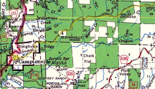
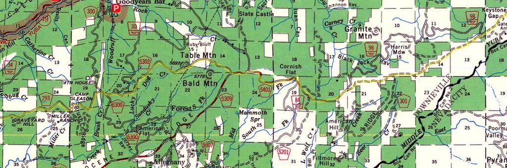
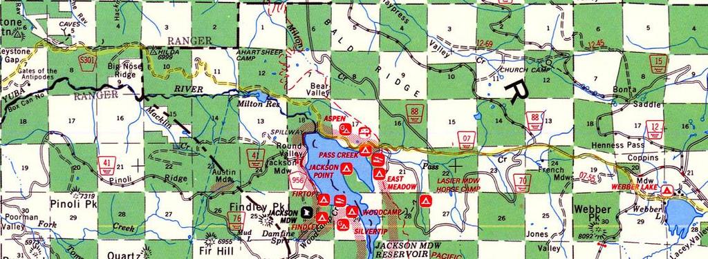
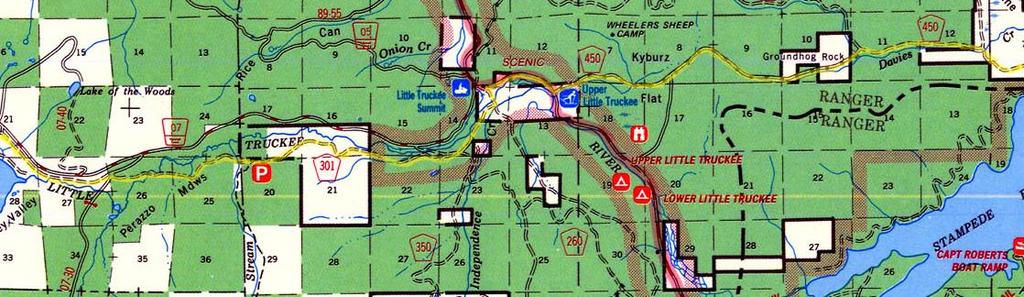
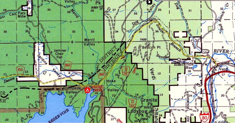
1 Henness Pass Road Hi-Landers October 2013 Club Run Trail Boss: Rich Bugarin Home # Cell# rbugarin@hi-landers.com Meet at the Grass Valley Lumber Jack Restraint at 9:00am on Saturday October 26 Th, 2013 Lumber Jack is located at 2075 Nevada City Hwy, Grass Valley, CA Take Hy 49 to Grass Valley take the Brunswick exit, Left on Brunswick then right on Nevada City Hwy for one block to Lumber Jack on the. This run is a full day it is 100 miles from Grass Valley to Verdi Nevada. It is SUV/high clearance 2WD capable and should run through the fall color change. I understand it is the only Trans Sierra back road/dirt road (other than the 10 rated Rubicon Trail). Have a good breakfast; bring a lunch and plenty of drinks/water and I suggest you top off your gas tank in Grass Valley there is an AM/PM near the Lumber jack we are meeting at. The run ends near Reno and is a good chance for a weekend getaway before returning home. Trail Routes: Hy 49 to Camptonville, Henness Pass Road is forest service 293, Then FS S302, FS S309, FS S301 past Milton Reservoir continue on FS S301, Left onto FS 07 at Jackson Meadows Reservoir, Just pass Webber lake turn off of FS 70 onto FS 301, HY 89, FS 450, FS 860 to Verdi Nevada From Ghost Town Explorers Webpage Located in the Tahoe National Forest, Henness Pass Road was thought to have been laid out around 1849 and construction began in 1852 as a wagon toll road from Nevada to the gold fields of California. The road starts on Highway 49 at either Camptonville or a south fork at Oregon Creek where a covered bridge built in the 1860's is still in use. The Henness Pass Road ends in Verdi Nevada. By 1859 the California gold rush was dying down and with the discovery of silver in the Nevada Comstock, a mass exodus of miners from California to Nevada began. The Henness Pass road with it's established mining towns and stage stops became one of the primary routes to the Comstock second to the Placerville-Carson route to the south. So plans to improve the road began. In 1859, the Truckee Turnpike Company was organized to build a road from Marysville to North San Juan in order to connect up with the Henness Pass Road. Not to be left out, in Nevada City the Henness Pass Turnpike Company was formed to hook up Nevada City to the Henness Pass Road at Eureka. The two company's joined forces and, using the old emigrant route, built a road all the way to Virginia City. Between 1860 and 1868, the road was extremely busy, kind of like the Riverside freeway on a Friday! The traffic was so bad that in order to regulate traffic, freight wagons ran during the day and stages ran at night. Even though there was considerable traffic on the Henness Pass Road, it was still second in use to the Placerville-Carson Route. When the Central Pacific Railroad was completed in 1868, the use of the Henness Pass route came to an end.
2 The Henness Pass Road is one of the last trans-sierra backroads that can still be driven today. The road is pretty much a high clearance two wheel drive dirt road with a few rough spots along the way. Part of the original road has been bypassed with a paved road near Jackson Meadows Reservoir and Weber Lake. I used the GPS and Topo on the laptop to try and stay on the original road, but we found that bridges were washed out and finally when we got near the 89 crossing, we hit our second washed out bridge and had to turn around and take the paved road to the 89. After crossing the 89, Henness Pass Road was a good dirt road all the way to Verdi Nevada where we lost it in a newer housing track. Henness Pass Trail Courtesy of the South Yuba River State Park The original Henness Pass road was primarily a road for an easier entrance into California. After the Donner Party disaster of 1846, emigrants avoided the rugged cliffs above Truckee (later Donner) Lake. Instead they turned northward taking a longer route developed by Patrick Henness (or Hanness) in either 1849 or 1850, although that is a subject of some debate. What is known is that Henness, along with his partner Jackson, is the probable discoverer of the pass that bears his name, and in 1852 the wagon road over it was improved in an attempt to draw overland emigrants to the country of North and Middle Yuba Rivers and to the towns in the Yuba and Nevada Counties. However, most emigrants continued to use the Echo Summit-Placerv lle rou e (Jo nson s Cu off). In 1855 the road was officially surveyed by D.B. Scott as part of the region's bid for selection as the site of the California State Wagon Road. Although Scott's survey spoke in the glowing terms of the relative ease of the route through the Henness Pass and gave low estimates on the cost of improvements, the route was passed over in favor of the road through El Dorado County. The Henness Pass Trail was a primary (and shorter route) to the Comstock Lode in Nevada. A major advantage of the Henness Pass route was its accessibility to trade via navigable Sacramento, Feather, and lower Yuba Rivers. Freight of all kinds loaded at San Francisco on river boats, barges, and steamers unloaded at Sacramento and Marysville and, depending on the dry or wet season, such other landings as Nicolaus, and Knights Landing, for transfer to teamsters, stages, and pack trains. Many camps and towns were created along the roads, the distances between determined by oxen moving seven to ten miles a day and horses and mules traveling twenty miles each day. Even during the peak years of use the Henness Pass road second to the Placerville-Carson route. The great need for transportation across the mountains, the crisis caused by the Civil War, and the need for gold and silver by both the North and the South contributed to the planning and building of the Central Pacific Railroad from Sacramento connecting with the railroad lines of the midwest and eastern United States. The opening of the railroad in 1868 and its completion in 1869 put an end to the heavy hauling over Henness pass. Thereafter it was used only for local traffic. Additional resources:
3
4
5
BROCHURE. APPLE HILL WOODS 118 +/- Acres Camino, California. Presented by Jim Copeland
 BROCHURE APPLE HILL WOODS 118 +/- Acres Camino, California Presented by Jim Copeland 1 The Property This 118 acre is a rare gem in the Sierra Nevada foothills. Covered with lush forestland and scattered
Black Rock Creek Ranch
 Black Rock Creek Ranch El Dorado County, California Proudly Offered By 707 Merchant Street, Suite 100, Vacaville, Ca 95688 (707) 455-4444 Office (707) 455-0455 Fax info@caoutdoorproperties.com www.californiaoutdoorproperties.com
Mother Lode Tour July 7 & 8, 2015
 Mother Lode Tour July 7 & 8, 2015 Tour leaves Orchard Creek at 8:30 AM July 7, 2015. Our exact route will be posted in late June so we don t have problems with road work. We will select roads that tend
Central Overland Trail Utah & Nevada Driving Guide, First Edition, 2016
 Central Overland Trail Utah & Nevada Driving Guide, First Edition, 2016 Page 51 In the third paragraph, second sentence, change 0.4 miles to 0.1 miles. In the fourth paragraph, second sentence, change
N E WSL E T T E R T H E T R A V E L E R
 LINCOLN HIGHWAY ASSOCIATION CALIFORNIA CHAPTER N E WSL E T T E R T H E T R A V E L E R E DI T O R; Gary K inst PUBLISHED QUARTERLY ON THE FIRST OF JANUARY, APRIL, JULY, OCTOBER V O L. 8 N O. 2 SPRIN G
DRAFT: FOR REVIEW PURPOSES ONLY. NOT FOR DISTRIBUTION.
 BACKBONE ENTER TITLE TRAILS HERE MAP Existing Regional Class 1 Trail (paved, separated from roadway) Proposed Regional Class 1 Trail (paved, separated from roadway) Proposed Regional Multi-Use Trail (natural
DOWNLOAD OR READ : USA CALIFORNIA NEVADA NATIONAL GEOGRAPHIC ADVENTURE TRAVEL MAP PDF EBOOK EPUB MOBI
 DOWNLOAD OR READ : USA CALIFORNIA NEVADA NATIONAL GEOGRAPHIC ADVENTURE TRAVEL MAP PDF EBOOK EPUB MOBI Page 1 Page 2 usa california nevada national geographic adventure travel map usa california nevada
MOUNTAIN BIKING THE CASCADE LOOP
 MOUNTAIN BIKING THE CASCADE LOOP By Henry Freimuth All photographs by Henry Freimuth The Cascades are on the Spanish Creek, which is a tributary of the Feather River. The Feather River was named by Spanish
Cost of Candidate Statement of Qualifications in Placer County for the November 4, 2008 Presidential General Election.
 Cost of Candidate Statement of Qualifications in Placer County for the November 4, 2008 Presidential General Election. Please note that the estimated cost of the Candidate Statement of Qualifications fee
BROCHURE Pilot Hill Meadows Acres Pilot Hill, California. Presented by Jim Copeland
 BROCHURE Pilot Hill Meadows 58.09 Acres Pilot Hill, California Presented by Jim Copeland 1 The Property This 58 acres is a portion of the 304 acre Pilot Hill Ranch in Pilot Hill and is a separate legal
CONNECT WITH SUCCESS!
 CONNECT WITH SUCCESS! SCADA CONVENTION State of California Auto Dismantlers Association No other industry event offers this opportunity to discuss California business issues and solve problems with the
Chapter 2: El Dorado County Characteristics and Demographics
 Chapter 2: El Dorado County Characteristics and Demographics 2.1 Geographic Area and Demographics El Dorado County comprises 1,805 square miles with over half of the area in the Eldorado National Forest
BROCHURE Sierra Foothills Ranch 55 Acres Pilot Hill, California. Presented by Jim Copeland
 BROCHURE Sierra Foothills Ranch 55 Acres Pilot Hill, California Presented by Jim Copeland 1 The Property This 55 acres is located midway between the historic California gold rush towns of Placerville and
BROCHURE. Brandy Hill Ranch 300 Acres Placerville, California
 BROCHURE Brandy Hill Ranch 300 Acres Placerville, California Presented by Jim Copeland Shown by appointment 1 The Property This 300-acre ranch is a rare gem in the Sierra Nevada foothills and is located
Rice s Crossing Road and Bridge
 s Crossing Road and Bridge s Crossing Road begins at Oregon House in Yuba County, traverses the Yuba River at s Crossing (former bridge site), and continues across South Yuba River State Park on its way
RECREATION AND RESORT PROJECTS
 RECREATION AND RESORT PROJECTS Coyote Moon Golf Clubhouse, Truckee, CA Dollar Point Pool and Tennis Club, Tahoe City, CA Donner Lake Boat Ramp, Truckee, CA Tahoe Swiss Village Beach and Shore Frontage,
THE TRACK CAR The Official Newsletter of West Coast Railroaders Group Copyright 2019 West Coast Railroaders Group All rights reserved.
 THE TRACK CAR The Official Newsletter of West Coast Railroaders Group Upcoming WCRG Events Vintage Track Car Rides: Roaring Camp Railroad Felton, California. Track Car Rides fundraiser benefiting Make-A-Wish
BROCHURE Pilot Hill Ranch 304 Acres +/- Pilot Hill, CA. Presented by Jim Copeland
 BROCHURE Pilot Hill Ranch 304 Acres +/- Pilot Hill, CA Presented by Jim Copeland 1 The Property This gently rolling 304 acres of ranchland is located in Pilot Hill, midway between the historic California
CHAPTER 2 COUNTY PROFILE
 COUNTY PROFILE CHAPTER 2: COUNTY PROFILE This chapter provides a profile of Amador County, California, in the planning context of parks and recreation services. This profile includes a description of the
El Dorado County / Tahoe Roadwork Schedule Sunday through Saturday September 9 September 15, 2012
 Today s Date: Friday, September 7, 2012, #12-255 District: District 3 - Marysville, http://www.dot.ca.gov/dist3 Jody Jones, District Director Contact: Deanna Shoopman deanna_shoopman@dot.ca.gov 530. 741.4566
Hitting the Road for Adventure!
 Lake Tahoe Airstream Club September 2016 WBCCI \ 2016 Hitting the Road for Adventure! September: & October: & November: December: 2016 Rally & Event Schedule 9/9-12 Rally at Truckee River RV Park Truckee,
The Traveler LINCOLN HIGHWAY ASSOCIATION CALIFORNIA CHAPTER VOLUME 5 NUMBER 2 APRIL New Tours Highlight Lincoln Highway Across California
 LINCOLN L HIGHWAY The Traveler LINCOLN HIGHWAY ASSOCIATION CALIFORNIA CHAPTER www.lincolnhwy.org/ca/traveler VOLUME 5 NUMBER 2 APRIL 2004 PUBLISHED QUARTERLY New Tours Highlight Lincoln Highway Across
For Sale High Visibility Commercial Land Ridge Rd. Sutter Creek, CA
 12300 Ridge Rd. Sutter Creek, CA 6 PARCELS TOTALING 9.69± ACRES To Jackson To Stockton 49 To Sacramento 49 To Jackson Rancheria 104 Ridge Road Sara Wann, SREA Gina Motto-Ros, Agent 1201 North McDowell
Sierra Roadwork Schedule Sunday through Saturday, October 1-7, 2017 LONG-TERM PROJECTS
 Date: September 29, 2017 #17-292 District: District 3 - Marysville, www.dot.ca.gov/dist3 Amarjeet S. Benipal, District Director Contact: Liza Whitmore, liza.whitmore@dot.ca.gov Phone: Office: (530) 634-7640
Tour 12 - Historic Plumas County
 SPECIALTY tour 12 page 1 Tour 12 - Historic Plumas County This tour highlights many of Plumas County s historic attractions and small museums. Local experts may be available for tours or presentations
Preparing for Writing Performance Tasks: Readying Students for Success in Writing and State Tests
 Preparing for Writing Performance Tasks: Readying Students for Success in Writing and State Tests "If students are to make knowledge their own, they must struggle with the details, wrestle with the facts,
CREW TYPE SUPERVISOR PHONE RANGER DISTRICT/Duty Station City. Helitack Staci Dickson Duty Station Nevada City
 Tahoe National Forest 2013 Temporary Fire Positions: American River Ranger District, Yuba River Ranger District, Truckee Ranger District and Sierraville Ranger District The Tahoe National Forest will soon
BID RESULTS FENCE-BULL RUN FIRE RESTORTATION-HUMBOLDT-TOIYABE NF, ELKO COUNTY #AG S
 ELKO COUNTY JAIL MEN'S & WOMEN'S HOUSING UNIT ADDITIONS, ELKO Elko County Commissioners 994 River Street Elko, NV 89801 PH: 000-000-0000 ARCHITECT: LOMBARD-CONRAD ARCHITECTS 392 5th Street Elko, NV 89801
Great Basin Drive, Yosemite to Las Vegas (C18A-3)
") Great Basin Drive, Yosemite to Las Vegas (C18A-3) After finishing up with the California parks, I left Yosemite and entered the Great Basin, which spans a large area east of the Sierra Nevada mountains
Great Basin Drive, Yosemite to Las Vegas (C18A-3) After finishing up with the California parks, I left Yosemite and entered the Great Basin, which spans a large area east of the Sierra Nevada mountains
Searchlight NV. Est Road is about 35 trail miles south of Searchlight. OLD CORRAL
 EAST LANFAIR VALLEY TRAIL NORTH The East Lanfair Valley Trail runs north/ south from Searchlight, NV to Goffs, CA, a distance of about 48 trail miles. The northern por on is also considered to be part
Northern Nevada Road Trip Various Locations, Nevada (N16C)
") Northern Nevada Road Trip Various Locations, Nevada (N16C) I moved to Nevada in January 2016. I had been to the state a number of times, often using Las Vegas as a starting point for road trips around
Northern Nevada Road Trip Various Locations, Nevada (N16C) I moved to Nevada in January 2016. I had been to the state a number of times, often using Las Vegas as a starting point for road trips around
The Life-force formula Immersion Wednesday June 7th Sunday June 11th, 2017 Shady Creek Event Center Pathfinder Way, Nevada City, Ca 95959
 General Info The Life-force formula Immersion Wednesday June 7th Sunday June 11th, 2017 Shady Creek Event Center 18601 Pathfinder Way, Nevada City, Ca 95959 Congratulations on making the decision to participate
California Section L - Page 1
 64 N. 63 N. 62 N. 725000m 726000m 727000m California Section L - Page 1 728000m 729000m 730000m CA Section L - 38.3 miles Start - Hwy 80 [Donner Summit], mile 1157.1 End - Hwy 49 [near Sierra City], mile
Overland Stagecoach Service through Tucson If it weren t for stagecoaches, Tucson wouldn t have developed to be the town we see today!
 Ring s Reflections by Bob Ring Overland Stagecoach Service through Tucson 1857-1880 If it weren t for stagecoaches, Tucson wouldn t have developed to be the town we see today! Let s set the stage (sorry).
SierraRescue.com ~ ~
 + SierraRescue.com ~ info@sierrarescue.com ~ 530-902-6122 HELLO FROM SIERRA RESCUE! Thanks for signing up for the WFR Review! The WFR Re-Certification is designed to recertify a wilderness first responder
FOCUSING ON REGIONAL CONNECTIVITY
 8 FOCUSING ON REGIONAL CONNECTIVITY Regional connectivity has three primary contexts in this RTP: the larger mega-region that extends from San Francisco to Reno-Sparks, the Northern Nevada and Lake Tahoe
Bodie State Historic Park
 Bodie State Historic Park Our Mission The mission of California State Parks is to provide for the health, inspiration and education of the people of California by helping to preserve the state s extraordinary
BROCHURE. FIDDLETOWN RANCH 714 +/- Acres Fiddletown Rd. Fiddletown, CA 95629
 BROCHURE FIDDLETOWN RANCH 714 +/- Acres 15640 Fiddletown Rd. Fiddletown, CA 95629 Offered by: Bruce Renfrew PH 650-773-1863 bruce@caoutdoorproperties.com BRE 01995642 And Jim Copeland PH 530-626-3943 jimcope@comcast.net
SIERRA BACKROADS------AUGUST 11-12, 2015
 SIERRA BACKROADS------AUGUST 11-12, 2015 We ll be truly exploring new country, for many of you, as we travel over paved U.S. Forestry roads into the heart of our Sierras---fun roads made for sport car
Upper Feather River Integrated Regional Water Management Planning Area. Administrative Boundaries
 L a s s e n V o l c a n i c W i l d e r n e s s L a s s e n V o l c a n i c Administrative Boundaries Bucks IRWM Hydroelectric Plant Sierra Sierra Canal or Ditch Pipeline, Aqueduct, Penstock National Forest
Carson City & Bishop
 Carson City & Bishop Spend a week riding Highway 395 and relearn what riding is all about! Carson City offers a variety of attractions, historic and modern. The city was named after Kit Carson and hit
No online items
 http://oac.cdlib.org/findaid/ark:/13030/tf009n97t4 No online items Processed by Lauren Lassleben, Project Archivist The Bancroft Library. University of California, Berkeley Berkeley, California, 94720-6000
Greenwood Creek Ranch El Dorado County, California Proudly Offered By
 Greenwood Creek Ranch El Dorado County, California Proudly Offered By 707 Merchant Street, Suite 100, Vacaville, Ca 95688 (707) 455-4444 Office (707) 455-0455 Fax info@caoutdoorproperties.com www.californiaoutdoorproperties.com
Lavic Jasper Field Trip
 Lavic Jasper Field Trip There are few places you can go and, once there, you park and step out of your vehicle and start collecting immediately. Lavic is one such place. In the bowl where our camping area
ECHOES FROM THE PA ST
 Founded July 24, 1968 and designated a 501(c)(3) in July 1971 Truckee Donner Historical Society P.O. Box 893 Truckee, CA 96160 530-582-0893 truckeehistory.org ECHOES FROM THE PA ST Dear Members, President's
El Dorado County / Tahoe Roadwork Schedule
 Today s Date: October 28, 2011 #11-267 District: District 3 - Marysville, http://www.dot.ca.gov/dist3 Jody Jones, District Director Contact: Deanna Shoopman deanna_shoopman@dot.ca.gov (530) 741-4566 desk
LINCOLN HIGHWAY ASSOCIATION CALIFORNIA CHAPTER N E WSL E T T E R T H E T R A V E L E R. E DI T O R Gary K inst
 LINCOLN HIGHWAY ASSOCIATION CALIFORNIA CHAPTER N E WSL E T T E R T H E T R A V E L E R E DI T O R Gary K inst PUBLISHED QUARTERLY ON THE FIRST OF JANUARY, APRIL, JULY, OCTOBER V O L. 11 N O.s 3 & 4 SU
California Section K - Page 1 WGS84 Zone 10S m
 750000m 751000m 752000m California Section K - Page 1 753000m 754000m 755000m WGS84 Zone 10S 757000m 04 N. 03 N. 04 N. 02 N. 05 N. 05 N. 06 N. 06 N. 01 N. Overnight camping is prohibited for approximately
Business Park. Amador Central. Offi ce / R&D Sites in Martell, CA FOR SALE & Build to Suit Opportunities DEVELOPMENT OPPORTUNITY. Blvd.
 DEVELOPMENT OPPORTUNITY Amador Central Business Park Offi ce / R&D Sites in Martell, CA FOR SALE & Build to Suit Opportunities 45 48 Locomoti ocomoti omo omo motive Ln Ln Ln Ln 47 46 44 35 Boxc xcar r
Cr./Left Fork of Boulder Creek/Horse Creek Made it 2.2 miles from Hwy on Left fork of Boulder Creek. Heavy washout;
 Road Inspector Inspection Inspection Date North Fork Mark M. 6/7 Open Boulder Cr. Helitack 6/16 no signs on either section of Boulder Cr. 2) we were able to make it to the creek crossing on Boulder Cr.
Business Park. Amador Central. Office / R&D Sites in Martell, CA FOR SALE & Build to Suit Opportunities DEVELOPMENT OPPORTUNITY. lvd a.
 DEVELOPMENT OPPORTUNITY Amador Central Business Park Office / R&D Sites in Martell, CA FOR SALE & Build to Suit Opportunities ppo t ities e iv ot m co Lo 47 47 46 46 37 3 7 38 38 Ln 45 45 lvd rb a c 35
Route #2) Mt. Massive - Southwest Slopes
 Mt. Massive - Southwest Slopes") Route #2) Mt. Massive - Southwest Slopes Difficulty: Class 2 Ski: Advanced, D6 / R2 / III Exposure: Summit Elevation: Trailhead Elevation: Elevation Gain: Round-trip Length: Trailhead: County Sheriff:
Route #2) Mt. Massive - Southwest Slopes Difficulty: Class 2 Ski: Advanced, D6 / R2 / III Exposure: Summit Elevation: Trailhead Elevation: Elevation Gain: Round-trip Length: Trailhead: County Sheriff:
Partners: Michigan California Timber Company Shasta-Trinity National Forest Pacific Crest Trail Association The Trust for Public Land
 Partners: Michigan California Timber Company Shasta-Trinity National Forest Pacific Crest Trail Association The Trust for Public Land Describe the project location, size, opportunities, and timing. Provide
! GoNevadaCounty.com Website Maintenance Contract JULY - DECEMBER 2015 EXTENSIONS
 ! GoNevadaCounty.com Website Maintenance Contract JULY - DECEMBER 2015 EXTENSIONS Website maintenance for GoNevadaCounty.com was subcontracted by the Nevada County Economic Resource Council by extending
Compiled by John Tamagni THE THOMPSON FAMILY
 Compiled by John Tamagni THE THOMPSON FAMILY William Burdette Thompson 1809-1853 Mary Ann Russell Thompson Cole 1818-1900 Fannie Thompson 1850-1856 1. William B. Thompson arrives at Bridgeport in 1849
Panning for History Michael Stahl
 Panning for History Michael Stahl The Young Scout troop went on a camping trip one weekend. The 12 boys and their patrol leader went into the woods close to their home city of Sacramento, located in the
FOR SALE. TOWN & COUNTRY BUILDING B TRUCKEE AIRPORT ROAD #2 Truckee, CA Listing Price: $685,750.00
 FOR SALE TOWN & COUNTRY BUILDING B 40169 TRUCKEE AIRPORT ROAD #2 Truckee, CA 96161 Listing Price: $685,750.00 Amazing Martis Valley View - Off Highway 267 South Breath-taking views of Northstar-at-Tahoe
The West Coast California Part 2
 The West Coast California Part 2 I have wanted to visit Yosemite National Park for years, always saying one day I ll get there. Well the time is here and I m going to spend 6 days exploring as much as
CREW TYPE SUPERVISOR /PHONE RANGER DISTRICT/Duty Station City
 Tahoe National Forest 2015 Temporary Fire Positions: American River Ranger District, Yuba River Ranger District, Truckee Ranger District and Sierraville Ranger District The Tahoe National Forest will soon
The Transcontinental Railroad
 Color Coded Notes Words in Red: Copy down exactly (word for word) from the slide. Words in Blue: Summarize in your own words. Words in Black: No need to write them down, just listen carefully to Mr. Sanders
LANDER COUNTY RAIL ASSESSMENT NOVEMBER 2006
 of hydrologic features. A substantial proportion of the land between and north of the railroad tracks contain wetlands, as identified by the US Fish and Wildlife Service National Wetlands Inventory (NWI).
LINCOLN HIGHWAY ASSOCIATION NEVADA CHAPTER MEETING RENO, NEVADA, July 16, 2016
 OFFICERS IN ATTENDANCE Cindy Ainsworth, President/State Director Vacant, Vice President Tom Davis, Treasurer Connie Davis, Secretary OTHERS IN ATTENDANCE LINCOLN HIGHWAY ASSOCIATION NEVADA CHAPTER MEETING
Reno/Carson City/Lake Tahoe NV Street Map (American Map) By Ameriacn Map
 By Ameriacn Map") Reno/Carson City/Lake Tahoe NV Street Map (American Map) By Ameriacn Map If looking for the ebook by Ameriacn Map Reno/Carson City/Lake Tahoe NV Street Map (American Map) in pdf form, then you have come
Reno/Carson City/Lake Tahoe NV Street Map (American Map) By Ameriacn Map If looking for the ebook by Ameriacn Map Reno/Carson City/Lake Tahoe NV Street Map (American Map) in pdf form, then you have come
Plumas National Forest
 nto River l Wildlife Ref Plumas National Forest life Refuge er National Wildlife Refuge 5 Tahoe National Forest Eldorado National Forest Eldorado National Forest-North Eldorado National Forest s Island
Bridgeport News South Yuba River State Park South Yuba River Park Association
 Bridgeport News South Yuba River State Park South Yuba River Park Association SYRPA Newsletter January 2016 IMPORTANT BRIDGE NEWS On December 13, 2015, two of the Bridgeport Park Rangers discovered that
TAHOE GETAWAY. Monday, October 1 through October 4, 2012
 TAHOE GETAWAY Monday, October 1 through October 4, 2012 COORDINATORS Sue Geisler --- Hiking Dennis Ratay --- Lodging Lodging is now filled. Waiting List: Anyone else interested in participating in the
BROCHURE. Bear Ridge Ranch 2820 Plubell Dr. Camino, CA 95709
 BROCHURE Bear Ridge Ranch 2820 Plubell Dr. Camino, CA 95709 Presented by Jim Copeland Shown by appointment only 1 The Property This 40-acre ranch is a rare gem in the Sierra Nevada foothills and is located
FOR LEASE WESTGATE SHOPPING CENTER. WESTGATE SHOPPING CENTER DONNER PASS ROAD #3 Truckee, CA 96161
 FOR LEASE 11429 DONNER PASS ROAD #3 2,004± Sq. Ft. prime retail space for lease in Westgate Shopping Center Busy shopping center with well-established tenant base and plenty of foot traffic. Presented
Hike at Pico Blanco Labor Day Weekend!
 Hike at Pico Blanco Labor Day Weekend! The Pico Blanco Hymn Here among the trees majestic Pleasures you will find On the trails of Pico Blanco With your friends and mine Trail the Eagle ever onward This
MP : The Big Chief Overlook and the Glen
 MP 253 254: The Big Chief Overlook and the Glen The mile between MP 253 and 254 has lots of history in it. It includes the only recorded remains of the Victory Highway on the Clear Creek County side of
Weston County, Wyoming
 The Sweet 200-Acre Property Weston County, Wyoming A unique opportunity to own a little piece of the old West, where one can experience unparalleled scenery, adventure and history walk in the footsteps
Water Cache Guidelines, Maps & Driving Directions
 Water Cache Guidelines, Maps & Driving Directions Fall 2017 Water Cache Guidelines on the Oregon Desert Trail Anyone planning to use the Oregon Desert Trail (ODT) is responsible for providing their own
 Augusta 287 200 287 Ovando 200 Lincoln Wolf Creek Craig Garnet 90 GARNET RANGE Drummond 141 Marysville 15 BIG BELT TAINS Granite Philipsburg 1 NGE CREEK Deer Lodge Elliston 12 Helena Rimini Comet 15 287
Indian Creek. Plumas County, California. Proudly Offered By
 Indian Creek Plumas County, California Proudly Offered By 707 Merchant Street, Suite 100, Vacaville, Ca 95688 (707) 455-4444 Office (707) 455-0455 Fax info@caoutdoorproperties.com Introduction House looking
Yucca Mountain Nuclear Fuel Locations and Associated Rail Facilities. Diablo Canyon Power Plant, California
 Yucca Mountain Nuclear Fuel Locations and Associated Rail Facilities Diablo Canyon Power Plant, California Yucca Mountain: Nuclear Fuel Locations and Associated Rail Facilities October 1, 2010 Final Report
OFFERING MEMORANDUM. Legends Books & Antiques 131 S. WASHINGTON ST., SONORA, CA 95370
 OFFERING MEMORANDUM Legends Books & Antiques 131 S. WASHINGTON ST., SONORA, CA 95370 02 CONTENTS PROPERTY HIGHLIGHTS PROPERTY OVERVIEW AND HISTORY PROPERTY PHOTOS RANKINGS LOCATION OVERVIEW DEMOGRAPHICS
The Loneliest Road in America Highway 50, Nevada (N16C)
") The Loneliest Road in America Highway 50, Nevada (N16C) U.S. Highway 50 crosses Nevada s mid-section, entering the state from Utah near Baker and Great Basin National Park, and leaving Nevada in the west
The Loneliest Road in America Highway 50, Nevada (N16C) U.S. Highway 50 crosses Nevada s mid-section, entering the state from Utah near Baker and Great Basin National Park, and leaving Nevada in the west
Section 1: Vocabulary. Be able to determine if the word in bold is used correctly in a sentence.
 Section 1: Vocabulary. Be able to determine if the word in bold is used correctly in a sentence. Hardships: difficult conditions or situations that cause discomfort and/or suffering Pioneers: the people
Camp Marin Sierra Winter Camping Information and Policies
 Camp Marin Sierra Winter Camping Information and Policies Camp Marin Sierra is a 320-acre facility bordered by thousands of acres of Tahoe National Forest land. Heading West, it is located on the right
Camp Marin Sierra Winter Camping Information and Policies
 Camp Marin Sierra Winter Camping Information and Policies Camp Marin Sierra is a 320-acre facility bordered by thousands of acres of Tahoe National Forest land. Heading West, it is located on the right
Reno/Carson City/Lake Tahoe NV Street Map (American Map) By Ameriacn Map
 By Ameriacn Map") Reno/Carson City/Lake Tahoe NV Street Map (American Map) By Ameriacn Map Reno, Nevada - Wikipedia, the free encyclopedia - Climate data for Reno, Nevada (Reno-Tahoe as part of his "A Map of the Floating
Reno/Carson City/Lake Tahoe NV Street Map (American Map) By Ameriacn Map Reno, Nevada - Wikipedia, the free encyclopedia - Climate data for Reno, Nevada (Reno-Tahoe as part of his "A Map of the Floating
CHAPTER 2. Introduction & Background
 Introduction & Background 2.1 Overview of Storey County Storey County is located in northwestern Nevada approximately 40 miles from the California state line. The western boundary follows township, range
E DI T O R Gary K inst PUBLISHED QUARTERLY ON THE FIRST OF JANUARY, APRIL, JULY, OCTOBER
 LINCOLN HIGHWAY ASSOCIATION CALIFORNIA CHAPTER N E WSL E T T E R T H E T R A V E L E R E DI T O R Gary K inst PUBLISHED QUARTERLY ON THE FIRST OF JANUARY, APRIL, JULY, OCTOBER V O L. 12 N O. 1 & 2 W IN
Silver Center Development USA Parkway & Highway 50 Silver Springs, Nevada
 O f f e r i n g M e m o r a n d u m Silver Center Development USA Parkway & Highway 50 Silver Springs, Nevada 25.7 Acres presented exclusively by Ron Cobb Principal Direct: (775) 329-4000 x103 Cell: (775)
LINCOLN HIGHWAY ASSOCIATION - CALIFORNIA CHAPTER EDITOR Gary Kinst
 THE TRAVELER LINCOLN HIGHWAY ASSOCIATION - CALIFORNIA CHAPTER www.lincolnhighwayassoc.org/ca/traveler EDITOR Gary Kinst PUBLISHED QUARTERLY ON THE FIRST OF JANUARY, APRIL, JULY, OCTOBER VOL. 17 NO. 4 FALL
Family Law Court Contact Information
 Family Law Court Contact Information County Alameda Alpine Amador Butte Calaveras Colusa Contra Costa Alameda Superior Court Hayward Hall of Justice 24405 Amador Street, Hayward, CA 94544 Alpine County
Fall e Campaign to Conserve. Royal Gorge
 Fall 2012 NSP PROJECT: ROYAL GORGE e Campaign to Conserve Royal Gorge Skiers on Rowton Peak's Razorback Trail with a view of Painted Rock and Lyon Peak David Galson As a life-long skier and a member of
Hoover Wilderness Region Trail Map: Twin Lakes, Lundy Lake, Bridgeport, Green Creek, Virginia Lakes, Buckeye Creek, Leavitt Meadows, Matterhorn Peak,
 Hoover Wilderness Region Trail Map: Twin Lakes, Lundy Lake, Bridgeport, Green Creek, Virginia Lakes, Buckeye Creek, Leavitt Meadows, Matterhorn Peak, (Tom Harrison Maps) By Tom Harrison If searched for
World-class adventures abound on the Sierra s western slopes
 World-class adventures abound on the Sierra s western slopes By Tom Stienstra September 17, 2017 Photo: Mason Trinca, Special To The Chronicle IMAGE 1 OF 4 Perry Norris, executive director of Truckee Donner
I I I JUNE LAKE. the other half of town. After a sharp S curve in the road by the power plant you will drive alongside Silver Lake.
 I I I JUNE LAKE T he June Lake Loop is a 15 mile road that loops around 4 lakes and a ski area, June Mountain. It begins and ends on US highway 395. The southern junction has a gas station and a gift shop.
College Avenue Campus Mettler, Stonier, and Tinsley Residence Halls General Instructions: Note: From New Jersey Turnpike (North or South) NOTE:
 NOTE:") College Avenue Campus Mettler, Stonier, and Tinsley Residence Halls General Instructions: Print directions and name of assigned building. Write your room number and phone number under the name of your
College Avenue Campus Mettler, Stonier, and Tinsley Residence Halls General Instructions: Print directions and name of assigned building. Write your room number and phone number under the name of your
Autumn in the Sierra
 October 2016 140 Where, when, and how to discover the best photography in America Published since 1989 37,57.0836N 119,13.3653W Autumn in the Sierra California s Aspen Groves If you enjoy photographing
Sonny Meadows A YOSEMITE AREA RANCH ESTATE
 ±443 Acre Magnificent Yosemite Area Estate Climb the mountains and get their good tidings. Nature's peace will flow into you as sunshine flows into trees. The winds will blow their own freshness into you,
RAILROAD THE BRISTOL. they thought, would be a better way to ship their lumber and produce to markets. It
 THE BRISTOL RAILROAD By GREG PAlIL Before there were railroads it was hard to travel in Vermont. Roads were narrow, rough, steep, and often muddy. Most people walked or rode horses. If they had heavy loads
COMMENT PERIOD. August 2, 2017 to September 1, 2017 INTRODUCTION
 DATE: July 31, 2017 TO: FROM: RE: Interested Persons Scott Johnson, Associate Planner Community Development Department NOTICE OF PREPARATION OF AN ENVIRONMENTAL IMPACT REPORT FOR THE SACRAMENTO CONVENTION
ASRA 2018 Hike Schedule
 ASRA 2018 Hike Schedule Date/Day Destination Hike Info Meeting Info Leader Feb 10, Saturday Stagecoach and 9:00 at the Confluence kiosk. Manzanita trails Parking fee required. We ll hike along the trail
History of the Denten Bridge
 History of the Denten Bridge By Scott J. Lawson, Plumas County Museum Director The subject of this piece is the historic Denten Bridge, located southeast of the town of Blairsden and east of Graeagle,
Lava Mountain Trail Distance: Elevation Range: Trail Type: Difficulty: Season: Driving Distance: Driving Time: USGS Maps: Pros Cons
 Lava Mountain Trail Distance: 13.4 miles (including the side trip to North Star Lake) Elevation Range: 5900'-8330' Trail Type: singletrack Difficulty: moderate Season: late June-October Driving Distance:
EDITOR; Gary Kinst PUBLISHED QUARTERLY ON THE FIRST OF JANUARY, APRIL, JULY, OCTOBER VOL.6 NO. 3 SUMMER JULY 2005 THE TRAILBLAZER
 LINCOLN HIGHWAY ASSOCIATION CALIFORNIA CHAPTER NEWSLETTER THE TRAVELER EDITOR; Gary Kinst PUBLISHED QUARTERLY ON THE FIRST OF JANUARY, APRIL, JULY, OCTOBER VOL.6 NO. 3 SUMMER JULY 2005 THE TRAILBLAZER
Houseworth: Houseworth, Thomas, San Francisco, Ca., Catalog, "VIEWS along and adjacent to the Central Pacific Railroad.
 Central Pacific Railroad Photographic History Museum LAWRENCE & THOMAS HOUSEWORTH STEREOGRAPH CATALOG # Miles Titles Additional Description Central Pacific Thomas Houseworth & Co., San Francisco. Central