Historic Overview DRAFT Southwest Corridor Existing Conditions Technical Report
|
|
|
- Roy Ford
- 5 years ago
- Views:
Transcription
1 Historic Overview DRAFT Southwest Corridor Existing Conditions Technical Report June 2012
2 About Metro Clean air and clean water do not stop at city limits or county lines. Neither does the need for jobs, a thriving economy and sustainable transportation and living choices for people and businesses in our region. Voters have asked Metro to help with the challenges and opportunities that affect the 25 cities and three counties in the Portland metropolitan area. A regional approach simply makes sense when it comes to making decisions about how the region grows, supports a resilient economy, keeps nature close by and responds to a changing climate. Metro works with communities to make this treasured place a great place to live, now and for generations to come. Stay in touch with news, stories and things to do.
3 ACKNOWLEDGEMENTS Southwest Corridor Plan project managers Tony Mendoza, Metro Malu Wilkinson, Metro Karen Withrow, Metro Jamie Snook, Metro Author Colin Rowan, Metro Reviewers Southwest Corridor Project Team Leaders Ben Bryant, City of Tualatin; Dennis Egner, City of Lake Oswego; Crista Gardner, Metro; John Gillam, City of Portland; Judith Gray, City of Tigard; Julia Hajduk, City of Sherwood; Talia Jacobson, ODOT; Steve L. Kelley, Washington County; Art Pearce, City of Portland; Alice Rouyer, City of Tualatin; Tyler Ryerson, City of Beaverton; Karen Schilling, Multnomah County; Lainie Smith, ODOT; Jay Sugnet, City of Portland; Morgan Tracy, City of Portland; Dave Unsworth, TriMet; Cliff Higgins, Metro
4
5 TABLE OF CONTENTS 1. Introduction Pre 1855 Native American History Early Euro American Traders and Settlers Historic Overview of Southwest Corridor Cities Beaverton Durham Lake Oswego King City Portland Sherwood Tigard Tualatin Transportation History River navigation and farm to market roads Rail transportation Age of the automobile Historic Preservation Key Findings Opportunities Constraints Works Cited Appendix A Building Footprints Historic Overview Report June
6 1. INTRODUCTION History is a string that ties our communities together; it provides a coherent narrative to inform our decisions based on the lessons of the past. The communities of the Southwest Corridor each have unique and shared histories. The study of these stories that define and connect the Corridor provide insight into the development patterns, cultures and built environments found throughout the area. This report chronicles the foundations of the cities in the Southwest Corridor, provides an account of the development patterns over time, gives an introduction to the transportation history of the Corridor and describes the historical preservation efforts demonstrated in each of the cities in the study area. 2. PRE 1855 NATIVE AMERICAN HISTORY Before the arrival of settlers of European descent, the Willamette and Tualatin River Valleys had long been home to American Indian peoples. Since c. 11,000 BCE, people have lived in the Pacific Northwest. Different groups have called the land in the Southwest Corridor home, the Atfalati (Tualatin) and the Chinookan Clackamas are the best documented, offering a primer, if not a complete picture, of life before European contact. The Tualatin Valley was long the home of the Atfalati people. A band of the Kalapuya tribe, the Atfalati (mispronounced by early settlers as Tualatin) lived in permanent villages near the shores of the now drained Wapato Lake in western Washington County. The Atfalati settled in longhouses on the valley floor rather than on the river highlands. The Atfalati routinely burned the valley floor in order to discourage the growth of forests. This practice resulted in favorable agricultural conditions monopolized by later settlers. Around 300 BCE the Chinook people settled along the Columbia and Willamette Rivers. The Chinook lived in small bands along the river highlands where they hunted for elk and deer, fished for salmon and gathered berries, acorns, camas and wapato. The bands would trade amongst themselves and with other tribes along the river valleys. One tribe of the Chinookan people to have lived in the area that is today Lake Oswego are the Clackamas (Zenk, 2008). The Clackamas lived along what is today the Clackamas River. The land where Lake Oswego is today was home to the tribe s western extent. According to accounts by the Lewis and Clark expedition, the tribe lived in eleven villages and had a population of roughly 1,800 people in Interactions with the expeditions brought disease to the Clackamas, decimating their population, exacting such a toll that by 1855 the remaining 88 survivors were relocated to the Grand Ronde Indian Reservation. (Boyd, 1994; City of Lake Oswego, n.d.). With the arrival of Euro American fur traders in the late 18 th century and settlers in the 19 th century came new germs and diseases, newfound competition and foreign concepts of land ownership and community. Despite new Western understanding of land ownership and 2 Historic Overview Report June 2012
7 discriminatory treatment, the Native people continued to maintain their identity and many traditions while the Euro American population increased in the area. 3. EARLY EURO AMERICAN TRADERS AND SETTLERS Euro American exploration and migration to the Pacific Northwest came in waves beginning with river explorations in the late 18 th century and culminated in the permanent settlements that were established in the 1840s. The first Euro Americans came to the Willamette Valley and the vicinity of the Southwest Corridor in the late 18 th century. Engaged in the Northwest China Trade, traders from eastern ports followed the trade route of Captain Robert Gray of Boston, Mass. This trade introduced Euro Americans to the Native tribes of the Pacific Northwest as they traded beaver pelts and fur. Leaving ports along the eastern seaboard, ships would make way for the mouth of the Columbia River. The vessels would be laden with foodstuffs, metals, textiles, firearms and trinkets to be traded with tribes along the rivers. The skins were then taken to Guangzhou, then known as Canton, where they were traded for tea, silks and porcelains. The Northwest China trade began with the voyage of the Columbia, which departed Boston in 1787 and returned in The trade s heyday came to a close in the early 1840s, when sea otter skins were depleted, the Native American population was reduced by disease and war, and the Chinese fur market was depressed due to civil strife and changing fashions (Krim, Rowan, & Frank, 2006). The first major overland expeditions to the Northwest were the explorations of the Louisiana Purchase, arriving in the Northwest in Meriwether Lewis, William Clark and their Corps of Discovery made their way to the mouth of the Columbia River and the Pacific Ocean (Bowen, 1978). The land that is today the city of Portland was first platted in 1844 to The city grew on the west side of the Willamette and soon eclipsed Oregon City as Oregon s premier city. The city grew because of its position near the confluence of the Willamette and Columbia Rivers. Merchants in the region looked inland instead of toward ocean bound trade routes. Known as the Inland Empire, the region developed steamboat and rail lines that supplied mining operations in Idaho and Montana. Wheat and livestock were traded through Portland and lumber trade was developed throughout the region. The cities that grew near Portland were often focused on providing local supplies and services. Some cities provided raw and finished materials for the region, such as Sherwood bricks. In the 1840s and 1850s, tens of thousands of new migrants found their way to the Pacific Northwest. The land of the Oregon Territory includes the present day states of Oregon, Washington, and parts of Idaho, Montana, and Wyoming. The Donation Land Claim Act of 1850 forever changed the region. The Donation Land Claim Act granted 320 acres to single, white men and 640 acres to married, white couples who established residency on the land Historic Overview Report June
8 before Dec. 1, This proclamation gave Euro American settlers legal and exclusive claim to the land, leading to the accelerated and forced removal of the native people. Those natives who had lived in tense coexistence with the white settlers were forcibly moved to reservations. The Donation Land Claim Act unleashed tens of thousands of farmers and city residents from eastern cities and throughout the Ohio River Valley. Oregon s Willamette Valley was the prime destination for many of these migrants at the Oregon Trail s end. Thanks to the annual burnings performed by the local American Indians, the valley floor was clear of trees and covered by tall grasses. Following the Oregon Trail, settlers arrived in Oregon City and spread throughout the valley (Cluver, 2012). The subsequent years saw rapid changes to the way land was developed, the growth of towns and cities, and connections to new transportation networks. The next section will provide brief histories of each city followed by an overview of transportation s role in connecting the Corridor. 4. HISTORIC OVERVIEW OF SOUTHWEST CORRIDOR CITIES This section provides a breakdown of each city s founding and a basic historical overview of the city s development. The sections provide a summary of the cities settlement patterns by Westerners. Particular detail will be given to the parts of the cities found in the Southwest Corridor. Through provision of individual histories tempts consideration of each city unto itself, it is important to regard the Corridor in a more comprehensive way, considering the linked histories and shared stories. The timeline below is provided to afford a chronological continuum to the European settlement of the Corridor City of Portland incorporated 1893 City of Beaverton incorporated 1893 City of Sherwood incorporated 1910 City of Lake Oswego incorporated 1913 City of Tualatin incorporated 1961 City of Tigard incorporated 1966 City of King City incorporated 1966 City of Durham incorporated 4.1 Beaverton 4 Historic Overview Report June 2012
9 Founded in 1893, Beaverton is named for the beavers which created large bodies of water throughout the Tualatin River Valley. The Atfalati Indians that lived in the area before western expansion called their villages Chakeipi, place of the beaver. The early settlers called the area Beaverdam and later Beaverton. (City of Beaverton, n.d.) Within the Southwest Corridor are the Beaverton neighborhoods of Greenway and Neighbors Southwest neighborhoods along Scholls Ferry Road such as Scholls. Much of the area s history can be understood by placenames. In the Southwest Corridor, off Hall Boulevard on Creekside Drive is the Augustus Fanno farmhouse. Namesake of Fanno Creek, Augustus Fanno, came to Oregon a schoolteacher but soon brought onion farming to the Tualatin Valley. Fanno made a small fortune by being the first to ship onions to Alaska during the Yukon Gold Rush. In the 1850s the Denney brothers built a farmhouse with their sister Rebecca along what is today Denney Avenue. The brothers built a sawmill along Fanno Creek and Rebecca started the area s first school. Augustus Fanno and Rebecca Denney, both school teachers, married in To this day, three of the American Freedom Trees stand where Augustus planted them in 1876 to celebrate the American centennial (End of the Oregon Trail Interpretative Center, 1998). Scholls Ferry Road creates some of the northwestern boundary of the Southwest Corridor data collection area, this road brought travelers to Peter Scholl s ferry across the Willamette. The ferry began operations shortly after Scholl took up a Donation Land Claim nearby in Durham Along the banks of the Tualatin River and adjacent to Boones Ferry Road, A. Alonzo Durham established a flour mill in Durham operated this mill until his death in The site was known as Durham Mills. With the building of the Oregon Electric Railway (detailed below), a stop was established at the location. The railway named the stop Durham, and the stop served as an important connection between farms and Portland along Boones Ferry Road. In the early 1900s many of the large trees found in Durham City Park were planted by the Pilkington Nursery, located adjacent to the park. In many ways, it was the presence of those commercially planted trees that led the city to be incorporated in Wary of industrial pressures on land in Tigard and Tualatin, residents voted to incorporate to protect the area from encroaching industrialization. The city has a strong tree ordinance which requires permits for tree removal and, through bond funded property acquisition; the city has acquired a number of wooded parcels and maintains the tree filled Durham City Park (City of Durham, n.d.). All of the city of Durham is within the Southwest Corridor data collection area. 4.3 Lake Oswego Historic Overview Report June
10 (Lake) Oswego was founded in 1847 by A. Alonzo Durham when he secured the first Donation Land Claim for the area. Durham named the new town after his New York hometown found on the banks of Lake Ontario. In Oswego, Durham established a sawmill operation at what was then called Sucker Creek (today s Oswego Creek). This was the area s first industry, but it was soon followed by iron mining operations when a vein of iron ore was discovered in the hills north of Sucker Creek. In 1865, the Oregon Iron Company was incorporated and led to Oswego being heralded as the Pittsburgh of the West. Oswego s iron mining and smelting industry employed more than 300 employees at its height (City of Lake Oswego, n.d.). At this time, narrow gauge railway was developed along the northern side of Sucker Creek, passing through Oswego and making a new connection to Portland. The Portland and Willamette Valley Railway Company operated the line and allowed for more reliable and quicker connections to be made (Scott, 1919). The development of electric interurbans in the 1910s moved Oswego into a first rate streetcar suburb. The iron company, now Oregon Iron & Steel, redeveloped their land, subdividing and platting their 24,000 acres of company land. Much of the early residential developments of the 1920s were built by the Ladd Estate Company (City of Lake Oswego, n.d.; Mills, 1945). The post war era brought rapid changes to Oswego. Residential development blossomed around the perimeter of Oswego Lake in the 1940s and 1950s. In 1960, Lake Grove was annexed and the city s name was changed to Lake Oswego (City of Lake Oswego, n.d.). The Lake Grove and Kruse Way areas of Lake Oswego are within the Southwest Corridor data collection area. 4.4 King City In 1963, the Tualatin Development Company originated the vision of the first senior community in the Portland region. Built on unincorporated land in Washington County, King City was created as an adult, 55 and older, community. Land was subdivided and residential streets were laid out around a nine hole golf course. At the beginning of 1964, the 250 acres of the adult community was still a farm; by the end of the year, the land was developed, houses built, golf course constructed, and the King City Civic Association incorporated. In 1965, the community was establishing itself through building programs and social events. Growth continued rapidly; in 1966, 270 homes were occupied, and the new town incorporated itself with the State of Oregon as a city (My King City, n.d.). Today, the city has annexed land near Bull Mountain; it remains primarily a senior community, but youth are now allowed to live in the city and access to schools is being provided in Tigard. The city remains a thriving and socially connected community (City of King City, n.d.). All of the City of King City is within the boundaries of the Southwest Corridor data collection area. 6 Historic Overview Report June 2012
11 4.5 Portland The city of Portland was first claimed and platted in by co founders Francis Pettygrove (from Portland, Maine) and Asa Lovejoy (from Boston, Massachusetts). Located midway between the established Fort Vancouver and the bustling frontier capital of Oregon City, Portland was famously named by chance of a coin toss between the cofounders. The city s growth and eventual prosperity would rely on superior transportation connections. It benefitted from being the head of navigation on the Willamette River for oceangoing vessels, as well as from the early construction of roads which made it the most economical shipping point for Oregon wheat to feed hungry California gold miners in the 1850s (Abbot, 2012). A number of neighborhoods and areas of Portland contribute to the story of the Southwest Corridor. Taken longitudinally, it can be seen as a transportation history of continued expansion, improved connection, and eventual spillover annexation. At the turn of the 20 th century, the area known as Southwest Portland today was largely outside of the city limits. Smaller areas such as Council Crest and the subdivisions of South Burlingame would be annexed in the early 20 th century. These annexations and the later integration of neighborhoods such as Multnomah and Hillsdale were possible by the rapidity and reliability of the streetcars radiating from downtown Portland at the time. The railways left a lasting imprint on the Corridor: the original rail grade that became Barbur Boulevard continued southwest toward Newberg and onward to Salem; the neighborhoods of southwest Portland were platted and connected to the central city through streetcars and interurbans. As the following section of this report will chronicle, the changes from the streetcar era to the automobile era would have profound impacts on the development patterns in Southwest Portland. In 1925, the City of Portland replaced the Fourth Avenue rail line with a surface street. Completion of Barbur Boulevard took almost a decade because of land acquisition issues, but soon automobile traffic was linking dispersed residential locations throughout the West Hills and south. Business quickly located autoorientated businesses along Barbur Boulevard (City of Portland, 2011). Annexation during the second half of the 20 th century brought many new neighborhoods into the city. Multnomah was first developed in the 1910s, based around the depot of the Oregon Electric Railway. Multnomah and the commercial district of Multnomah Village were annexed into the city of Portland in By the 1960s the rapid development of Washington County pressured Portland to annex several areas, increasing the population of the southwest area from about 15,000 to nearly 44,000 (City of Portland, 2011). During the 1950s and 1960s, most of the neighborhoods south of downtown were annexed into the city. Under the leadership of Mayor Terry Schrunk, the City of Portland implemented what Schrunk called a vigorous annexation policy (Abbot, 1983). The city accomplished more than two hundred annexations during the 1960s including a number of neighborhoods in the Southwest Corridor. Not all communities looked at the annexation by Portland in a Historic Overview Report June
12 positive light; Tigard successfully fended off annexation by incorporating as a city in Washington County in Also annexed in the 1950s 1960s was the community of Hillsdale. First settled by John Addison Slavin in 1850 through the Donation Land Claim Act, Slavin had a farm and constructed Slavin Road, now Capitol Highway, in order to provide better access to markets in Portland. In the 1920s, Slavin s subdivided land was host to the Portland West Side Auto Camp, an overnight auto camping rest area that included cabins and camping areas. While the area was known as Hillsdale since the 1880s, it was not until 1996 that the boundaries and definitional identity of the community was enshrined through the establishment of the Hillsdale neighborhood association (Your Roadmap to Home, n.d.). In the late 1960s, a proposed housing project in Hillsdale was stopped because city planners wanted to preserve the area s social isolation (Abbot, 1983). The city continues to change, redevelop and rebuild. Hillsdale and Southwest Portland neighborhoods can no longer be considered isolated, as they are tightly woven into the fabric of Portland and the other cities of the Corridor. Near the turn of the 20 th century Portland was the third largest city in the American West, today it is the 13 th largest city west of the Mississippi. 4.6 Sherwood By the 1870s, many families were living in the area around today s Sherwood. In 1885, James Christopher and Mary Ellen Smock gave right of way across their property to the Portland & Willamette River Valley Railway. With the depot established, the Smocks platted what is today Old Town in The town that grew along those streets came to be known as Smockville. A town meeting was held with most of the residents present in order to rename the town. Robert Alexander of Sherwood, Michigan suggested Sherwood in honor of his hometown and England s famed Sherwood Forest. The Town of Sherwood was incorporated in The initial industry of the town was the brickyard that supplied building bricks for much of Portland s rapid growth during this period. At this time most of Sherwood s historic commercial buildings were constructed, including the nine block brick façade of Old Town. A victim of the 1893 recession, the brickyard closed in The economy shifted, becoming more diverse and resilient. For most of the city s history a fruit and vegetable cannery and a tannery supported gradual growth. Rapid sprawl emanating from Portland and radiating along the Sunset Highway made Sherwood an attractive exurb beginning in the 1970s and continuing at an accelerated rate in the mid to late 1990s (City of Sherwood, n.d.). 4.7 Tigard In 1852, Wilson M. Tigard arrived in the Oregon Territory by wagon from Arkansas. When Tigard arrived to the Tualatin Valley, the land was already taken by land claims. Friends in the area encouraged the young Tigard to move to the area to work as a school teacher (Tigard, 2010). The city was known as East Butte until 1886, when Tigard s son, Charles, 8 Historic Overview Report June 2012
13 petitioned for a post office to be opened in his general store located on the corner of Southwest McDonald Street and Southwest Pacific Highway. In order to incent the petition, Charles Tigard offered to serve as postmaster for two years without pay (Tigard, 2010). As was the custom of the time, the Postal Service named the location and address for the applicant, in this case naming the facility Tigardville (Payne, 1979). The Tigardville General Store was the center of the small community, housing fraternal organizations such as the Odd Fellows, a small library and, in 1901, the area s first telephone (Payne, 1979). As rail service by interurban reached Tigardville, the station name was shortened to Tigard to avoid confusion with the later stop at Wilsonville. The village center was moved along the rail line between 1907 and 1910 as several small commercial buildings went up in the new commercial area (Buan, 1999). The rail line spurred residential growth in the area independent of large farm tracts. In 1916, the Tigard Lumber Company began operation and built a number of new houses near the station. The 1930s were a time of slow growth and gradual improvements. During this time, a civic association paved the streets and sidewalks of the downtown area and improved connections by road were made in order encourage automobile travel. Population slowly increased through the post war era, remaining just above three hundred until the late 1950s and 1960s brought a phenomenal population growth (Buan, 1999). In order to stop continued pressure for annexation by the city of Portland, the people of Tigard incorporated in Washington County in Lake Oswego, Tigard, and Beaverton effectively created a barrier stopping Portland s possible southward expansion (Abbot, 1983). The city continued to grow, attracting a number of industrial and commercial businesses to the Tigard Triangle during the 1980s and 1990s and the annexation of an area around Bull Mountain in 2004, and River Terrace in The city continues to redevelop and change. All of Tigard is within the study area. 4.8 Tualatin The City of Tualatin has been on the move, literally; since 1853 the town has been shifting its center and its name. The city began as the small village of Galbreath, built on the north side of the Tualatin River ferry crossing. In 1853, Samuel Galbreath began his ferry service; later, he built the first toll bridge across the Tualatin. Soon after the building of Galbreath s bridge, the town s name was changed to Bridgeport. The thriving village located itself along Boone s Ferry Road and provided crossing for travelers moving throughout the Willamette Valley. In 1886, the Portland & Willamette Railway Company purchased right of way through John Sweek s land. Sweek took advantage of this windfall by platting a new town around the railroad depot, selling the land and renaming the town Tualatin. Buoyed by the success of the Tualatin Mill Company s payroll, the town grew quickly. Historic Overview Report June
14 The city s center shifted again in 1906 with the building of the Oregon Electric Railroad s Portland Salem line. In 1913, the booming city incorporated and continued growing based on improved agricultural technology. Many new immigrants found their way to Tualatin, including a large number of Italian immigrants, (Buan, 1999). The new Italian families developed the onion flats between Tualatin and Sherwood during the early 20 th century (Martinazzi, 1994). Other specialty crops of the area included irises and other flower crops. The city grew as more people were attracted to the area. Investors purchased farms and subdivided lands as the electric rail connection put Portland only one hour away. Improved roads such as Boones Ferry Road allowed for greater automobile connections. During the 1960s, the city drew many new residents attracted to its suburb location, proximity to Washington County attractions, Portland, and Salem to the south. In 1970, the city annexed a great deal of this rapidly developing land in order to place certain controls on the development. Annexation brought tracts of land for industry and, in 1985, the city added a large tract to the west (City of Tualatin). The city continues to grow, offering industrial, institutional and commercial development opportunities in addition to residential life. Tualatin Town Center and westward are located within the Southwest Corridor study area. 5. TRANSPORTATION HISTORY Transportation technology has spurred the growth of the Southwest Corridor. Cities within the data collection area and throughout the region have grown and changed based on available transportation technologies. Land use patterns and spatial orientation of businesses and housing has been contingent on these developments. Initially, transportation was reliant on the earliest highways: rivers. River travel was the quickest and cheapest mode of transportation and vessels plied the waters of the Tualatin River and the Willamette River. Farm to market roads were developed throughout the area as well as roads connecting to ferry services. Initially muddy tracks, these roads slowly improved as plank roads and other improvements were added. Orientation of development shifted with the development of rail service throughout the area. First interurban service came, followed by streetcar and more local services. At the height of the streetcar and electric interurban era came the advent of the automobile age. Nothing would be the same again. The automobile removed the necessity to locate businesses and residential uses near commercial and transportation centers. The building of Interstate 5 and improvements to Highway 99W paved the way for increased automobility. The farms of the area were quickly converted as changing housing patterns brought residents out of the cities in the post war era. 5.1 River navigation and farm to market roads Farmers in the area found a lucrative and important market for their crops as soon as settlements developed. The California gold fields were located on land with poor 10 Historic Overview Report June 2012
15 agricultural potential and were claimed by men with little time to work their lands for agricultural subsistence. Soon, Tualatin and Willamette Valley farmers were shipping their goods to this lucrative market. A deepwater port was necessary and as Oregon City, Linn City, Linnton, and St. Helens all vied for control of the agricultural trade it was Portland s proximity to the Tualatin Valley farms and the existence of a year round deep water port that allowed it to become the regional shipping center. A rudimentary plank road was constructed by the Portland and Valley Plank Road Company. Receiving a charter from the territorial government, the company laid about ten miles of planks before they ran out of money in 1851 (Buan, 1999). Eventually, railroads would prove to be much more reliable long distance conveyors of market goods as roads were built radiating from rail stations, making easier local connections to rail stations. The difficulty of overland travel before and during the early rail period meant that rivers were the ideal transportation for most of the 19 th century. Steamboats and crossing ferries plied the Willamette and the Tualatin Rivers in the Southwest Corridor. In 1856, the legislature chartered the Tualatin River Transportation and Navigation Company to improve the Tualatin River in order to prepare it for navigation. The company was formed by John Taylor, operator of Taylor s Ferry and builder of Taylor s Ferry Road (Martinazzi, 1994). Though steamboats successfully navigated the river, full improvements, canals or locks were never completed. Many of the roads familiar today in the Southwest Corridor, Scholls Ferry Road, Capitol Highway, Taylors Ferry Road, and Boones Ferry Road, were built by purveyors of ferry services, guiding activities throughout the region along their roads. For a time, the Tualatin River Navigation Project operated a railroad that connected Sucker Lake (now Oswego Lake) to the Willamette, bridging the transportation gap (Buan, 1999). A canal was cut in 1871 near today s Lake Grove that connected Sucker Lake to the Tualatin River. This link was utilized by logging entities and farmers until replaced by rail connections. Remnants of the canal remain visible today. The planned connection between Sucker Lake and the Willamette River was never made because of the advent of quality rail service and difficult water levels at key times in the year. Throughout the 19 th century, sidewheeler steam service made connections along the Tualatin River from Oswego to Hillsboro and, eventually, riverway improvements were made that allowed navigation westward to Cornelius (Timmen, 1973). 5.2 Rail transportation The early story of rail transportation in the area is one of political power and financial intrigue. The first railroad through the Southwest Corridor was started with a legislative grant given to Joseph Gaston. Grant requirements stated that he needed to complete 20 miles of rail by With half of the work complete Ben Holladay of Pony Express wealth came to Portland and, with $35,000 of political bribes and graft, Holladay was able to wrangle the grant from Gaston. Holladay s actions led to development of the new towns of Beaverton and Sherwood. When the residents of Hillsboro and Forest Grove balked at Holladay s actions, Holladay aligned his service to the south, bolstering the town of Historic Overview Report June
16 Beaverton. Ten years later, the building of the Oregon & Transcontinental Railroad led to the platting of Sherwood (Buan, 1999). Growth continued at a slow pace, facilitated by rail service and farm to market roads that connected to rail stations until the advent of the first electric interurbans, the first commuter service. The first decade of the twentieth century was a time of frenzied electric railway building. Two new systems were built in Oregon: the Oregon Electric Railway Company lines and the Southern Pacific, known first as the Portland, Eugene & Eastern Railway. Along what today is Highway 99W, the Oregon Electric built tracks that followed the shoulder of the west hills to Bertha, while Southern Pacific had tracks at a higher elevation. The Oregon Electric continued south to Wilsonville. Opening to initial success, it would soon become a pawn in an intercontinental business battle between the Northern Pacific & Great Northern s James J. Hill and the Union Pacific s Edward Harriman. Beginning with gaining control of Chicago, then Seattle, Spokane and Portland, a rush of railroad building and competition eventually found the Oregon Electric being purchased by Hill (Mills R., 1943). The Oregon Electric Railroad s line passed the stations of Tigard and Tualatin, changing the cities housing patterns and opportunities to move freight other than by wagon road or via the Tualatin River connection. The Southern Pacific line, by way of Union Pacific, countered Hill s actions. They revealed a plan to make a web of electric interurbans that would make connections throughout the Willamette Valley. This system, almost overnight, created excitement about new improved connections. The Southern Pacific line served the communities of what is today the Southwest Corridor. These trains were called the Red Electrics because of the distinctive red engines and cars with portholes for the engineers. Though Hill s Oregon Electric line was considered finer, the service provided by the Red Electric created new demand to the small towns south of Portland (Mills R., 1943). Much of the labor to build these early rail lines was performed by Chinese immigrants and migrants from California brought to Oregon for the railroad construction. Many Chinese made their way north from California to seek new agricultural and labor opportunities. A host of exclusionary laws were created in order to restrict Chinese from enjoying the fullbenefits of their labors. Chinese exclusionary laws often would bar re entry, establishment of residency, and a host of civil rights in Oregon and California (Griffith, 2007). The Chinese laborers were often poorly treated by the communities in which they lived and where they worked. Their labors helped to create the rail lines and they invested money earned within the communities where they lived. This exclusion inspired Chinese fraternal organizations and other beneficiary societies that helped Chinese businesses open and flourish, defying oppressive and restrictive laws. It wasn t until the eve of World War II that Chinese residents, some families having been in the United States for almost a century, were given the right of citizenship. 5.3 Age of the automobile 12 Historic Overview Report June 2012
17 As Randall Mills writes, though Oregon had some of the finest interurban systems, still, there were those who remembered that Buick that arrived in 1908, (Mills R., 1943). Automania found its way to Oregon at the same time that the interurbans were developing. More and more automobiles were cluttering the country roads tourists with running boards overloaded with wondrous camping paraphernalia, Sunday drivers out for a ride, farmers on the way to market, drummers and salesmen on their rounds (Mills R. V., 1945). In 1908 there were seven hundred automobiles in the state of Oregon; by 1912 there were ten thousand; two years later there were sixteen thousand; and by 1920, there were over one hundred thousand automobiles registered in Oregon (Mills R. V., 1945). People began to abandon the trolleys and interurbans that had done so much to establish the early suburbs of the region. In 1913, Oregon took the first steps in creating an integrated highway system to accommodate this boom. The country s first statewide gasoline tax was instated by Oregon in This tax largely paid for the development of state highways and supported ongoing maintenance (Watson, 1950). The purpose of the State Highway Department can be summarized by their 1913 slogan: Get Oregon Out of the Mud. The state went about making road and bridge improvements, stabilizing the sides of roads and building new roads. Based on the hard work of the Good Roads Movement spearheaded by bicyclists, paving improvements were undertaken throughout the country. Watson states that the bicycle is the grandpapa of the Oregon State Highway financing system (Watson, 1950). The 1901 legislature provided for the construction of bicycle paths on either or both sides of all public highways of the state for the use of pedestrians and bicycles (Ibid.). A tax was levied on all bicyclists representing the first transportation user fee. The good roads for bicyclists were soon seen to be improvements that would aid increasing adoption of motor vehicles, and the success of road user fees was applied to the gas tax for automobiles (Terry, 2011). In the Southwest Corridor, the arrival of motordom brought severe and lasting changes to the development and land use patterns. The City of Portland went about creating a number of roads that linked the central city to outlying suburbs. Barbur Boulevard was one of the first major highway projects undertaken in the 1930s. Running south from Portland on the route of the then abandoned Southern Pacific rail line, Barbur Boulevard allowed Portland s downtown to begin stretching south, eventually the building of highway interchanges would effectively disrupt this expansion (Abbot, 1983). It took the City of Portland a decade of negotiations with the Southern Pacific railroad and various regulatory commissions, but in 1931 the city acquired the unused railroad right of way and in 1934 opened Barbur Boulevard. Barbur Boulevard was slowly connected to other stretches of former rail lines and roads to create Highway 99W. Named for the City Commissioner of Public Works, Asberry Barbur, Barbur Boulevard provided an early demonstration of automobile oriented development patterns. The City of Portland realized that automobile oriented roads might bring unwanted development, so the 1924 zoning code that allocated land to apartments and businesses was down zoned in 1935 in order to preserve a scenic entrance to the city and to protect the Burlingame Historic Overview Report June
18 neighborhood (Abbot, 1983). In the end, this technique did not work and low density singlefamily housing quickly located adjacent to auto oriented business strips built along the highway. Auto and motor courts, restaurants (such as the Original Pancake House), driveins, and gas stations were quickly built. In 1950, the Fred Meyer supermarket the chain s longest continuously operating store was opened. Oriented to the highway and not to a neighborhood, the supermarket represents the shift in design and focus of the nation. In the 1950s and 1960s, the creation of the interstate highway system led to bulldozing of neighborhoods such as Lair Hill in the Southwest Corridor in order to create Interstate 5 and Interstate 405. In 1966, Interstate 5 was completed. Running parallel to many parts of Highway 99W, Interstate 5 allowed for quick access to the blossoming towns south of Portland. Highway 99W transitioned from highway to urban arterial street during this period (City of Portland, 2011). Rapid growth on a scale never before seen took place in the subsequent decades. New land uses and designs promoted automobility. While the nation s course has shifted, the cities of the Southwest Corridor retain aspects of their historic beginnings. 6. HISTORIC PRESERVATION The first historic preservation ordinance in the United States was enacted in Charleston, South Carolina in Ultimately, that ordinance proved discriminatory, but it opened the door to other efforts such as the preservation of the French Quarter in New Orleans, Lousiana and a larger national movement. In 1966, the National Historic Preservation Act (NHPA) established the National Register of Historic Places. Each year the list of designated properties grows, providing a cultural trust and connection to historical buildings and sites that define the development of the nation. From this Act came the National Register Historic Districts such as Portland s Skidmore/Old Town and South Portland Historic Districts. These districts are geographical areas with a concentration of historically significant properties. The table below provides a survey of the historic preservation and inventory efforts in the Southwest Corridor. Most cities in the Southwest Corridor have groups concerned about historic preservation. These are: Beaverton Historical Society, Oswego Town Historical Society and the Oswego Heritage Council, Portland Historical Society, Inc., Sherwood Historical Society, Tigard Historical Society, Tualatin Historical Society, Washington County Museum, the Oregon Historical Society, and many citizens concenred with historic preservation. These groups coordinate historical preservation and curation of historical artifacts and oral histories. By maintaining the stories of the past we give voice to the future. City Beaverton Historic Preservation and Inventory efforts The City of Beaverton has identified many historic resources through a Historic Resource Inventory process that has been repeated three times. 14 Historic Overview Report June 2012
19 Downtown Beaverton is a Historic District. Historic Review process No Historic Districts in Southwest Corridor, but many designated historic properties and landmarks One listed National Register Historic Place in Southwest Corridor: Augustus Fanno Farmhouse. Durham King City Lake Oswego Historic Resources Inventory The City has identified no historic or cultural areas in the City. Historic Resources Inventory Historic Resources Advisory Board, Historic Preservation Chapter (LOC 58), Historic Preservation Plan (1989), Cultural Resources Inventory (1989). Old Town Design District preserves historic design elements. Four listed National Register Historic Places in Southwest Corridor: Bates House No. 2, No. 3, No. 4, and the Lake Oswego Hunt Club Ensemble. Portland Historic Resources Inventory, Historic Design review, historic Designation Review, Historic Preservation Incentive Review Historic Resource Protection overlay zones; South Portland Historic District and part of the Skidmore/ Old Town Historic District are within the Southwest Corridor study area. Many historic landmarks and Register of Historic Places found in the downtown portion of the Corridor and southward. Sherwood Historic Resources Inventory Old Town Overlay zone with Old Town Design Guidelines to direct design in the Smockville subdivision and neighborhoods generally considered Old Town. No National Register Historic Places. Tigard Historic Resources Inventory Two Historic District overlays governed by Municipal Code Title Historic Overview Report June
20 Historic Overlay zone which protects the buildings in the Districts. Two listed National Register Historic Places in Southwest Corridor: Tigard House and Rider Family Cabin. Tualatin Historic Resources Inventory A number of historic sites are listed in the Comprehensive Plan. One listed National Register Historic Place in Southwest Corridor: Meadowbrook. 7. KEY FINDINGS The Tualatin and Willamette River Valleys have provided sustenance for thousands of years for hundreds of thousands of people. The developments of the late 20th century forever changed the way the land is used. Many of these changes were exacerbated and facilitated by the rapid development of transportation technology. Rapid adoption of motor vehicles quickly altered traditional travel patterns, allowed new connections and increased mobility. Workers could live in one town and travel quickly to the central city or elsewhere for work. Land choice was no longer dominated by transportation options. These patterns are manifested in each of the cities of the Southwest Corridor, resulting in a predominance of single family residential neighborhoods where families have room for a yard and other amenities. To this day, services remain located along the main arterials of the cities allowing continued intercity connections. The cities of the Southwest Corridor each have unique and rich histories. While each City can be better understood through detailed study of important people and occurrences, a more comprehensive understanding is gained through the study of their shared histories. Appreciated as a group of interconnected woven communities we understand the role that transportation, farming, housing developments, and new industries have had on the area over the intervening century and half. 7.1 Opportunities The historic origins of the Southwest Corridor allows for the study of a number of themes. It is possible to see the development patterns over time and begin to understand how quickly certain changes happened. Historical perspective also makes it possible to understand how the veins of Highway 99W and Highway 217 have carried the lifeblood of the communities for more than a hundred years. Serving in this capacity, the land development patterns adjacent to these roads has changed radically over the years. Study of the Corridor s history will help explore the desirability of those changes and inform future developments. It is 16 Historic Overview Report June 2012
21 impossible to understand where we re going without looking back to where we are coming from. 7.2 Constraints The history of the Southwest Corridor provides few constraints. The challenges presented lies in the reconciliation of the different histories of the cities and their place within the region. As some cities developed in response to actions taken by adjacent cities, it is important to reflect on sometimes challenging relationships and local identities. By synthesizing the many histories and political conflicts, a metahistory of net progress can be written. WORKS CITED Abbot, C. (2012). "Portland, Oregon". Encyclopedia of American Urban History: SAGE Reference Online, Abbot, C. (1983). Portland: Planning, politics, and Growth in a Twentieth Century City. Lincoln, Neb.: University of Nebraska Press. Bowen, W. A. (1978). the Willamette Valley: Migration and Settlement on the Oregon Frontier. Seattle: University of Washington Press. Boyd, R. (1994). The Northwest Measles Epidemic of Oregon Historical Quarterly, 95 (1), Buan, C. (1999). This far off sunset land: a pictoral history of Washington County, Oregon. Virginia Beach, VA: The Donning Company Publishers. City of Beaverton. (n.d.). Beaverton History. Retrieved February 2, 2012, from City of Beaverton website: City of Durham. (n.d.). City of Durham Welcome Page. Retrieved February 03, 2012, from City of Durham City Hall: oregon.us/ City of King City. (n.d.). City of King City, Oregon video. Retrieved February 02, 2012, from Welcome to King City: City of Lake Oswego. (n.d.). A Brief History. Retrieved February 02, 2012, from Lake Oswego Public Library: lo/history.htm City of Portland. (2011). Barbur Concept Plan, Existing Conditions Report. Bureau of Planning & Sustainability. Portland: City of Portland. Historic Overview Report June
22 City of Sherwood. (n.d.). City History. Retrieved February 06, 2012, from City of Tualatin, Oregon: history City of Tualatin. (n.d.). Tualatin Annexation history. Retrieved February 08, 2012, from City of Tualatin : Cluver, C. (2012). Farming Families on the Oregon Frontier". Retrieved January 31, 2012, from Encyclopedia of Immigration and Migration in the American West: SAGE Reference Online End of the Oregon Trail Interpretative Center. (1998). Augustus Fanno emigrant of Retrieved December 2006, from End of the Oregon Trail Interpretative Center: Griffith, S. (2007). Dreams of the West: A History of the Chinese in Oregon, Portland, Oregon: Portland State University Press. Krim, R., Rowan, C., & Frank, M. (2006). Innovate Boston!: Shaping the future from our past: four amazing centuries of history. Boston, Mass.: Boston History & Innovation Collaborative. Martinazzi, L. a. (1994). Tualatin: from the beginning. Tualatin, Ore.: Tualatin Historical Society. Mills, R. (1943). Early Electric Interurbans in Oregon II: The Oregon Electric and Southern Pacific Systems. Oregon Historical Quarterly, 44 (4), 386=410. Mills, R. V. (1945). Recent History of Oregon's Electric Interurbans. Oregon Historical Quarterly, 46 (2), My King City. (n.d.). King City History. Retrieved February 02, 2012, from My King City Ken and Vicki's Real Estate: Payne, M. (1979). Tigardville Tigard. Lake Oswego, Ore.: Lake Grove Printing Company. Scott, L. M. (1919). History of the Narrow Gauge Railroad in the Willamette Valley. The Quarterly of the Oregon Historical Society, 20 (2), Terry, J. (2011, January 22). Portland enjoys a golden age of cycling a century ago. The Oregonian. Tigard, C. (2010, October 1). Curtis Tigard Interview. (S. Murdoch, Interviewer) Timmen, F. (1973). Blow for the Landing. Caldwell, Idaho: The Caxton Printers, Ltd. Watson, R. (1950). Casual and factual Glimpses at the Beginning and Development of Oregon's Roads and Highways. Salem, Oregon: State of Oregon State Highway Commission. 18 Historic Overview Report June 2012
23 Your Roadmap to Home. (n.d.). Hillsdale District SW Portland Homes. Retrieved February 02, 2012, from Portland Neighborhoods: Zenk, H. (2008). Notes on native American Place Names of the Willamette Valley Region. Oregon Historical Quarterly, 109 (1), Historic Overview Report June
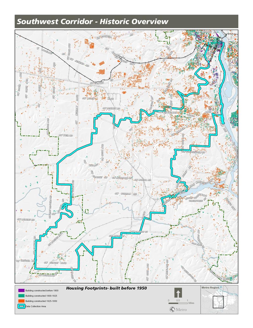
24 APPENDIX A BUILDING FOOTPRINTS 20 Historic Overview Report June 2012

25 Historic Overview Report June


26 22 Historic Overview Report June 2012

27 Historic Overview Report June

28 24 Historic Overview Report June 2012
A view of the Tualatin Valley in about Webfooters Post Card Club PO Box Portland OR
 June 2013 Exploring Portland s Capitol Hill A view of the Tualatin Valley in about 1912. Webfooters Post Card Club PO Box 17240 Portland OR 97217-0240 www.thewebfooters.com In this issue Remembering Portland
December 2017 Oregon City First Capital City in The West
 December 2017 Oregon City First Capital City in The West A History of Oregon City see page 2. Webfooters Post Card Club PO Box 17240 Portland OR 97217-0240 www.thewebfooters.com Oregon City: The First
Airport Planning Area
 PLANNING AREA POLICIES l AIRPORT Airport Planning Area LOCATION AND CONTEXT The Airport Planning Area ( Airport area ) is a key part of Boise s economy and transportation network; it features a multi-purpose
At the time, the portion of the line through Eagle County remains wholly under the ownership of Union Pacific Railroad (UP).
.") Chapter 5 The Railroad Corridor as a Trail Corridor The intent of this chapter is to identify how the rail corridor, if available for lease or purchase in all or part, could be incorporated into the core
Chapter 5 The Railroad Corridor as a Trail Corridor The intent of this chapter is to identify how the rail corridor, if available for lease or purchase in all or part, could be incorporated into the core
Here is one more (a big one) for tomorrow s hearing. Thanks and let me know if you have questions! Aaron C. Deas Office of Government Affairs
 for tomorrow s hearing. Thanks and let me know if you have questions! Aaron C. Deas Office of Government Affairs") From: To: Subject: Date: Attachments: Deas, Aaron JWMCC Exhibits HB 5530 Testimony - TriMet Thursday, May 18, 2017 1:54:09 PM 2017-05-18-SWCLightRail SupportFULL.pdf Here is one more (a big one) for tomorrow
From: To: Subject: Date: Attachments: Deas, Aaron JWMCC Exhibits HB 5530 Testimony - TriMet Thursday, May 18, 2017 1:54:09 PM 2017-05-18-SWCLightRail SupportFULL.pdf Here is one more (a big one) for tomorrow
Section 1: Vocabulary. Be able to determine if the word in bold is used correctly in a sentence.
 Section 1: Vocabulary. Be able to determine if the word in bold is used correctly in a sentence. Hardships: difficult conditions or situations that cause discomfort and/or suffering Pioneers: the people
CHAPTER 4 -- THE LAND USE PLAN: DESCRIPTIONS AND POLICIES FOR THIRTEEN PLANNING AREAS
 CHAPTER 4 -- THE LAND USE PLAN: DESCRIPTIONS AND POLICIES FOR THIRTEEN PLANNING AREAS NORTH CENTRAL CAC AREA LITTLE VALLEY ROAD TO JUG HANDLE CREEK PLANNING AREA This planning area includes Cleone, Noyo,
The Tacoma Star of Destiny
 The Tacoma Star of Destiny The Tacoma Star of Destiny is an advertising tool that was developed early in the 20th century touting all the advantages of Tacoma, WA. The following is the list of the manufacturers,
MINNESOTA ARCHITECTURE - HISTORY INVENTORY FORM Property Location
 MINNESOTA ARCHITECTURE - HISTORY INVENTORY FORM ------ - Property Location -- ---- Property Name: Washington Park Address: 215 N 4th Street County: Blue Earth City/Twp: Mankato PIN: R01.09.07.461.001 Legal
Gardner: overview. Santa Fe, Oregon, and California National Historic Trails UNINCORPORATED JOHNSON COUNTY OLATHE UNINCORPORATED JOHNSON COUNTY
 Santa Fe, Oregon, and California ational Historic Trails : overview 99: p.134 100: p.135 GARDER JUCTIO 102: p.137 56: p.126 EDGERTO Burlington orthern Intermodal and Logistics 98: p.133 101: p.136 S Waverly
A History of Beaverton
 March 2017 A History of Beaverton The newly completed Oregon Electric Depot in Beaverton in 1909. A History of Beaverton see page 3. Webfooters Post Card Club PO Box 17240 Portland OR 97217-0240 www.thewebfooters.com
Economy 3. This region s economy was based on agriculture. 4. This region produced items such as textiles, iron, and ships in great quantities. For th
 Geography 1. This region has a climate of warm summers and snowy cold winters. 2. This region has a climate that is generally warm and sunny, with long, hot, humid summers, and mild winters, and heavy
CHAPTER 1 INTRODUCTION MORENO VALLEY GENERAL PLAN 1. INTRODUCTION. 1.1 What is a General Plan?
 1. INTRODUCTION 1.1 What is a General Plan? A General Plan is a comprehensive long-term strategy for the physical development of a city. It determines how land may be used and the infrastructure and public
APPENDIX OFFICIAL MAP ORDINANCE OF HAMILTONBAN TOWNSHIP OFFICIAL MAP NARRATIVE
 APPENDIX A OFFICIAL MAP ORDINANCE OF HAMILTONBAN TOWNSHIP OFFICIAL MAP NARRATIVE INTRODUCTION: The Official Map of Hamiltonban Township has been prepared to identify those lands and features that Hamiltonban
STREET STATEMENT OF SIGNIFICANCE MARCH 2017
 1195 12 TH STREET STATEMENT OF SIGNIFICANCE MARCH 2017 HISTORIC CONTEXT The Rush House is located in the historic Ambleside neighbourhood of West Vancouver. Due to its position along the Burrard Inlet,
Westbrook Station. Transit Oriented Development Opportunity
 DEVELOPM Westbrook Station Transit Oriented Development Opportunity OPPOR Table of Contents Prime Real Estate Development Opportunity page 1 Calgary City of Opportunity page 3 What is Transit Oriented
ROADBUILDERS THEATRE
 SCRIPTED PRESENTATION [Sam Hill] Welcome everyone to the conference and to today s presentation of early road building in Washington. More specifically we will look at some techniques that were first used
Mankato s Transportation Heritage
 Mankato s Transportation Heritage City of Mankato Mankato Heritage Preservation Commission May 11, 2017 1. Union Depot, 112 S. Riverfront Drive, c. 1896. The railroads were Mankato s dominant transportation
Unit 11: Travel and Trade
 Unit 11: Travel and Trade Today Due: Current Events Article Assignment Quiz: Unit 10 (Value of Land) In class: Unit 11 (Travel and Trade) HW: wkbk 97-102, study for quiz 11, read Unit 12 (155-166) Lesson
Chapter 2: Summary of Existing Open Space System
 Chapter 2: Summary of Existing Open Space System In 1976, the Wake County Board of Commissioners established the Wake County Parks and Recreation Department in order to provide park facilities and programs
In 1850, Congress passed a law donating two and one half million acres to the State of Illinois for the use of the Illinois Central Rail Road.
 Merna The town of Merna was founded by primarily Irish and German farmers. Their faith and families were an integral part of who they were. There was and still is today a strong sense of community. Most
Largest cities in the United States by population by decade
 1 of 17 11/15/2008 7:30 AM Largest cities in the United States by population by decade From Wikipedia, the free encyclopedia This entry tracks and ranks the population of the largest cities in the United
Curriculum Pacing Guide Grade/Course 5 Th Grade Geography Grading Period 1 st Nine Weeks
 2013-2014 Curriculum Pacing Guide Grade/Course 5 Th Grade Grading Period 1 st Nine Weeks Time Frame Unit/ photographs, pictures, and tables to Locate and identify: Continents and Oceans -North America
Chapter 6: POLICY AND PROCEDURE RECOMMENDATIONS
 Chapter 6 POLICY AND PROCEDURE RECOMMENDATIONS FOR SRRA Below are seven policy elements that should be considered for adoption by the Southwest Regional Recreation Authority of Virginia: 1. Develop strategies
SOUTH INTERCHANGE AREA
 Santaquin City General Plan 1 Location and Characteristics The South Interchange Area of Santaquin is located west of Interstate 15 and south of 500 South (Figure 1). It includes properties already annexed
Leasing Brochure. Park Plaza Shopping Center 1150 N. Federal Highway, Pompano Beach, Florida Under Construction - Coming Very Soon
 Park Plaza Shopping Center 1150 N. Federal Highway, Pompano Beach, Florida 33062 Leasing Brochure Under Construction - Coming Very Soon Exclusive Leasing Broker 2048 East Sample Road, Lighthouse Point,
Communication in the West and the Transcontinental Railroad!!!
 Communication in the West and the Transcontinental Railroad!!! What was communication like during Westward Expansion? If people wanted to get letters from the West back to the East, the fastest way was
Map 1.1 Wenatchee Watershed Land Ownership
 Map 1.1 Wenatchee Watershed Land Ownership Map 1.1 Wenatchee Watershed Land Ownership The Wenatchee watershed lies in the heart of Washington state in Chelan County. Just larger than the state of Rhode
CHAPTER FIVE PROSPECTS FOR FUTURE ECONOMIC DEVELOPMENT
 CHAPTER FIVE PROSPECTS FOR FUTURE ECONOMIC DEVELOPMENT 5.1 GENERAL The recommended type and location of future land uses in Alpine should, in part, consider potential opportunities for future economic
Part Three : COMMUNITY PLAN AREAS AND SPECIAL STUDY AREAS SACRAMENTO 2030 GENERAL PLAN. Introduction
 Special study Areas Part Three : COMMUNITY PLAN AREAS AND SPECIAL STUDY AREAS SACRAMENTO 2030 GENERAL PLAN Introduction Beyond the boundaries of the 2030 General Plan, the City has defined Special Study
Aviation, Rail, & Trucking 6-1
 6-1 This chapter describes the services, facilities, and condition of air, rail, and trucking as components of the transportation system. These three intermodal areas have an impact on the factors to be
Section II. Planning & Public Process Planning for the Baker/Carver Regional Trail began in 2010 as a City of Minnetrista initiative.
 Section II Planning & Public Process Planning for the began in 2010 as a City of initiative. city staff began discussions with the Park District on the possibility of a north/south regional trail connection
To Mumbai, Back and Forth. Circulatory Urbanism Photo Essay. Photos by Ishan Tankha Text by Rahul Srivastava and Matias Echanove
 To Mumbai, Back and Forth Circulatory Urbanism Photo Essay Photos by Ishan Tankha Text by Rahul Srivastava and Matias Echanove This photo essay is an extract from a study by the Institute of Urbanology.
O HARA TOWNSHIP. Chapter 2 - Early History. Comprehensive Development Plan
 O HARA TOWNSHIP Chapter 2 - Early History The O Hara Township History Committee has assembled a significant volume of historical data from primary and secondary sources, about persons, places and events
A CASE FOR COMPLETING THE JORDAN RIVER PARKWAY: A
 A CASE FOR COMPLETING THE JORDAN RIVER PARKWAY: A safe crossing at 9000 South and 850 West Proposed 9000 South Underpass Parkway Timeline Parkway, Trail, and Tourism Facts Blueprint Jordan River 1971 1973
// LEARN // ENGAGE // VOLUNTEER // DONATE // PROJECT OVERVIEW MAP
 // LEARN // ENGAGE // VOLUNTEER // DONATE // PROJECT OVERVIEW MAP PROJECT OVERVIEW MAP The Atlanta BeltLine is a dynamic and transformative project for Atlanta. Through the development of a new transit
CHAPTER 1. INTRODUCTION AND BACKGROUND
 SETTING CHAPTER 1. INTRODUCTION AND BACKGROUND The City and Borough of Juneau (CBJ) is located in the central portion of the Alaskan panhandle, approximately 700 miles from Anchorage and 950 miles from
THE ALBERTA GAZETTE, SEPTEMBER
 VILLAGE OF CEREAL Order No. 16915 IN THE MATTER OF THE "Municipal Government Act": File No. 241(A)3 AND IN THE MATTER OF an application by the Council of the Village of Cereal, in the Province of Alberta,
Hearings will be held in the Shirley Huffman Auditorium in the Charles D. Cameron Public Services Building, 155 North First Avenue, Hillsboro, Oregon.
 Hearings will be held in the Shirley Huffman Auditorium in the Charles D. Cameron Public Services Building, 155 North First Avenue, Hillsboro, Oregon. On September 24, 2013, the Board of County Commissioners
Transportation. By: Matthew Kikkert
 Transportation By: Matthew Kikkert Early Transportation Dirt roads began to connect major cities in the early 1700s, but conditions were very poor and dangerous. Taverns sprung up on these roads and were
The Sunshine Coast is part of the global community and generates wealth through export, high-value industries and new investment.
 3.2 Strategic intent 3.2.1 Shaping growth an overview In 2031, the Sunshine Coast is renowned for its vibrant economy, ecological values, unique character and strong sense of community. It is Australia
A CONCEPT FOR F.H. BARBER PROVINCIAL PARK.
 A CONCEPT FOR F.H. BARBER PROVINCIAL PARK. 2-7-4-101-27 APPROVAL This Concept for F.H. Barber Provincial Park has been reviewed and is approved. Lower Mainland Region Parks and Outdoor Recreation Division
Historic Highway Advisory Committee To Meet in The Dalles
 In This Issue Get Involved Highway Gets Major Endorsement New Life for the Old Road Bike Pods and Hubs Time Travel on the Historic Highway Gorge Ride 2014 The Historic Columbia River Highway News is your
BLACK POINT COMMUNITY PLAN UPDATE ADVISORY COMMITTEE
 BLACK POINT COMMUNITY PLAN UPDATE ADVISORY COMMITTEE Thursday, March 20, 2014 6:00 8:00 PM Novato Atherton Fire Department Training Room 450 Atherton Avenue Novato, CA 94945 AGENDA 1. Review and accept
The following trails completed their work utilizing funds awarded by the Greenways Foundation:
 The Greenways Foundation Grant Awards 2013 and 2014 Our grant program has been in place since 2012 and is funded entirely by the proceeds received through our Indiana BMV specialty license plate. Please
Segment 2: La Crescent to Miller s Corner
 goal of the USFWS refuges is to conserve, protect and enhance fish, wildlife and plants and their habitats for the continuing benefit of the American people. Refuge lands are used largely for fishing,
4.0 Context for the Crossing Project
 4.0 Context for the Crossing Project This section provides background information about key features of the North Douglas Crossing project area, and opportunities and constraints. This information is important
Cascade River State Park Management Plan Amendment
 This document is made available electronically by the Minnesota Legislative Reference Library as part of an ongoing digital archiving project. http://www.leg.state.mn.us/lrl/lrl.asp Cascade River State
COMMITTEE OF THE WHOLE PLANNING COMMISSION MEETING. City and Borough of Juneau Mike Satre, Chairman. 6:00 p.m. August 12, 2014
 COMMITTEE OF THE WHOLE PLANNING COMMISSION MEETING City and Borough of Juneau Mike Satre, Chairman 6:00 p.m. August 12, 2014 I. ROLL CALL Dennis Watson, Vice Chairman, called the Committee of the Whole
RAY YENKANA Willowbrook Cr, Dawson Creek BC Canada $2,847,000
 1716 Willowbrook Cr, Dawson Creek BC Canada For SALE $2,847,000 This is a rare find, 32 townhomes in Dawson Creek, BC. Excellent investment in a single title multi family complex. Vendor has upgraded this
Business Item No
 Metropolitan Parks and Open Space Commission Meeting date: February 6, 2018 For the Community Development Committee meeting of February 20, 2018 For the Metropolitan Council meeting of February 28, 2018
South Lake Union History Trail
 South Lake Union History Trail Seattle Starts Here: Welcome to the History Trail Travel through 150 years of history, from wilderness to world city, right at the water s edge and the city s heart. Explore
Boise Municipal Code. Chapter DEFINITIONS
 Chapter 12-03 DEFINITIONS Sections: 12-03-01 ADMINISTRATOR 12-03-02 AIRPORT DESIGNATIONS 12-03-03 AIRPORT HAZARD 12-03-04 AIRPORT HEIGHT LIMITATIONS 12-03-05 AIRPORT REFERENCE POINT 12-03-06 AIRPORT INSTRUMENT
PROPOSED ALTERATION AND EXPANSION OF THE MOUNT PEARL MUNICIPAL BOUNDARY TO INCLUDE THE AREA OF THE FORMER PEARL ESTATE LANDS & ENVIRONS
 PROPOSED ALTERATION AND EXPANSION OF THE MOUNT PEARL MUNICIPAL BOUNDARY TO INCLUDE THE AREA OF THE FORMER PEARL ESTATE LANDS & ENVIRONS JANUARY 4, 2007 INTRODUCTION In accordance with Sections 3 to 6 inclusive
Director, Community Planning, Toronto and East York District
 STAFF REPORT October 25, 2005 To: From: : Subject: Toronto and East York Community Council Director, Community Planning, Toronto and East York District Status Report OPA & Rezoning Application 05 117524
Preparing for Writing Performance Tasks: Readying Students for Success in Writing and State Tests
 Preparing for Writing Performance Tasks: Readying Students for Success in Writing and State Tests "If students are to make knowledge their own, they must struggle with the details, wrestle with the facts,
NATIONAL AIRSPACE POLICY OF NEW ZEALAND
 NATIONAL AIRSPACE POLICY OF NEW ZEALAND APRIL 2012 FOREWORD TO NATIONAL AIRSPACE POLICY STATEMENT When the government issued Connecting New Zealand, its policy direction for transport in August 2011, one
TOWERBUTTE. Lewis and Clark s. >> By Jerry Penry, LS
 4.95 Lewis and Clark s TOWERBUTTE >> By Jerry Penry, LS Have you ever felt like you are standing on hallowed ground, knowing that some very important surveyors had previously occupied that same location?
Bayshore Boulevard: A Brief Look at its Historic Past
 Sunland Tribune Volume 20 Article 8 1994 Bayshore Boulevard: A Brief Look at its Historic Past Charles A. Brown Follow this and additional works at: http://scholarcommons.usf.edu/sunlandtribune Recommended
2. Goals and Policies. The following are the adopted Parks and Trails Goals for Stillwater Township:
 D. PARKS AND TRAILS 1. Introduction Stillwater Township s population is relatively low, with most residents living on rural residences on large lots. The need for active park space has been minimal in
Spanish Missions History and Purpose
 Spanish Missions History and Purpose Columbus's voyage of discovery opened a new world of possibilities for the Spanish. In the Americas, Spain soon began to use its soldiers to increase the size of its
NOTE: YOU MAY COMPLETE THIS SURVEY ONLINE (USING THIS DOCUMENT TO VIEW MAPS AND GRAPHICS) AT:
 AT:") for completing the Town of Beech Mountain Comprehensive Planning Survey. The information you provide in reply to the following questions will be used to help the Town develop a plan that will guide our
for completing the Town of Beech Mountain Comprehensive Planning Survey. The information you provide in reply to the following questions will be used to help the Town develop a plan that will guide our
Introduction. The City of Elk Grove
 The Quiet Zone Application Process: Lessons Learned from Elk Grove, California 8/22/05 By: Dominic Spaethling, PB; Barry Lemke, PB; Gwen Owens, City of Elk Grove, CA Introduction The City of Elk Grove
Inquiry: Was It Destiny To Move West? Supporting Question 2: What new technologies influenced westward expansion?
 Inquiry: Was It Destiny To Move West? Supporting Question 2: What new technologies influenced westward expansion? Supporting Question 2: Directions: (1) Keep all papers organized and back in order after
I INTRODUCTION AND BACKGROUND
 I INTRODUCTION AND BACKGROUND INTRODUCTION AND BACKGROUND - I I INTRODUCTION AND BACKGROUND a. project setting Looking south to the project site The Davenport Cement Plant (also referred to as the Cemex
FNORTHWEST ARKANSAS WESTERN BELTWAY FEASIBILITY STUDY
 FNORTHWEST ARKANSAS WESTERN BELTWAY FEASIBILITY STUDY EXECUTIVE SUMMARY The 2030 Northwest Arkansas Regional Transportation Plan developed by the Northwest Arkansas Regional Planning Commission (NWARPC)
The Transportation Corridor Overlay District
 The Transportation Corridor Overlay District The Transportation Corridor Overlay District is a policy framework under which certain potentially beneficial development proposals may be considered, given
A History of West Chicago
 A History of West Chicago The Prairie Prairie Inhabitants Winfield Mounds Dickson Mounds, near Lewistown, in southern Illinois. An example of what Native burial mounds look like. First Permanent Settlers
When the trail took off over ten years ago, no one could have imagined the holistic benefits across North and South Carolina since then, or the
 When the trail took off over ten years ago, no one could have imagined the holistic benefits across North and South Carolina since then, or the wholehearted community engagement. It is a brilliant system
PROUDLY BRINGING YOU CANADA AT ITS BEST. Management Planning Program NEWSLETTER #1 OCTOBER, 2000
 PROUDLY BRINGING YOU CANADA AT ITS BEST VUNTUT NATIONAL PARK Management Planning Program NEWSLETTER #1 OCTOBER, 2000 INTRODUCTION This newsletter launches the development of the first management plan for
Northeast Quadrant Distinctive Features
 NORTHEAST QUADRANT Northeast Quadrant Distinctive Features LAND USE The Northeast Quadrant includes all the area within the planning area that is east of Interstate 5 and to the north of State Route 44.
INTRODUCTION 250,000
 INTRODUCTION The United States of America has over 250,000 rivers, with a total of about 3,500,000 miles of rivers. The main stems of 38 rivers in the United States are at least 500 miles (800 km) long.
EXHIBIT 1. BOARD AUTHORIZATION FOR PUBLIC HEARING AND SUBSEQUENT ISSUANCE OF A JOINT DEVELOPMENT SOLICITATION
 EXHIBIT 1. BOARD AUTHORIZATION FOR PUBLIC HEARING AND SUBSEQUENT ISSUANCE OF A JOINT DEVELOPMENT SOLICITATION Washington Metropolitan Area Transit Authority Board Action/Information Summary @Action O Information
Oak Park Historic District
 2.2.25 Oak Park Historic District Ordinance # 2007-094 and 2008-11 December 4, 2007 and March 4, 2008 Oak Park Historic District The Oak Park Historic District represents the commercial core of Oak Park,
Corporate Environmental Leadership Seminar Yale School of Forestry & Environmental Studies June 4-15, 2000
 KLEE 443 Corporate Environmental Leadership Seminar Yale School of Forestry & Environmental Studies June 4-15, 2000 Robert J. Klee M.E.S., Yale School of Forestry & Environmental Studies, 1999 ECO-INDUSTRIAL
A VISION FOR EL MIRAGE
 el mirage A VISION FOR EL MIRAGE OASIS, ARIZONA A thriving desert jewel destination with a strong arts district, high-wage employment parks system joined together by cohesive, multi-use accessible trails
Parkland County Municipal Development Plan Amendment Acheson Industrial Area Structure Plan
 Parkland County Municipal Development Plan Amendment Acheson Industrial Area Structure Plan New Plan Acheson Industrial Area Structure Plan Amendment Parkland County Municipal Development Plan Board Reference
FEASIBILITY CRITERIA
 This chapter describes the methodology and criteria used to evaluate the feasibility of developing trails throughout the study areas. Land availability, habitat sensitivity, roadway crossings and on-street
Longmont to Boulder Regional Trail Jay Road Connection DRAFT FINAL REPORT
 Longmont to Boulder Regional Trail Jay Road Connection DRAFT FINAL REPORT December 2018 Project Summary Boulder County, Colorado, in partnership with the City of Boulder, is evaluating options for multi-use
OFFERING MEMORANDUM. Applebee s - Ground Lease Walmart Supercenter Outparcel Warren, MI
 Applebee s - Ground Lease Walmart Supercenter Outparcel Warren, MI Florida Investment Sales Exclusively Retail. Extensive Solutions. JOHN ARTOPE Executive Vice President, Market Leader D 407.902.2621 john.artope@srsre.com
AGENDA BILL. Beaverton City Council Beaverton, Oregon BUDGET IMPACT AMOUNT BUDGETED $0
 AGENDA BILL Beaverton City Council Beaverton, Oregon SUBJECT: Quarterly Update by Metro Councilor Kathryn Harrington FOR AGENDA OF: 03-22-16 BILL NO: 16055 Mayor's Approval: DEPARTMENT OF ORIGIN: Mayor
Land Distribution. Land Purchases. 14 The Nature of Settlement: Post-Revolution to the Civil War Changing Shape of New York
 14 The Nature of Settlement: Post-Revolution to the Civil War 1780-1865 Prof. Anthony Grande Geography Dept. Hunter College-CUNY Spring 2018 Settlement Sequence: State of New York Revolutionary War ends
The Falls: A Visitor & Interpretive Center for the Upper Lock
 The Falls: A Visitor & Interpretive Center for the Upper Lock Image courtesy of Northern Spark Surface by Aaron Dysart Illuminate the Lock is a program of Mississippi Park Connection The Falls Initiative
LEWIS & CLARK FALL/WINTER ACTIVITIES FOR THE WHOLE FAMILY February 15, 2005
 LEWIS & CLARK FALL/WINTER ACTIVITIES FOR THE WHOLE FAMILY February 15, 2005 STORY : National Signature Event entitled Destination: The Pacific November 11 through 15, 2005 Clatsop County Oregon & Pacific
A number of goals were identified during the initial work on this Big Lake Transportation Plan.
 C. Transportation General Background Information Big Lake s transportation system includes all the roads, paths and facilities that allow the movement of private vehicles, trains and planes, as well as
4. Safety Concerns Potential Short and Medium-Term Improvements
 NH Route 104 Access Management Study Page 19 4. Safety Concerns Potential Short and Medium-Term Improvements Potential safety improvement strategies are listed by priority based on field observations by
North Shore Lacamas Lake
 North Shore Lacamas Lake January 27, 2017 A Vision for Conservation and Recreation Acknowledgements Funding Funding for this planning effort was provided by the City of Camas and the Columbia Land rust
BEACON HILL, MOUNT BAKER & SEWARD PARK. community info
 BEACON HILL, MOUNT BAKER & SEWARD PARK community info BEACON HILL neighborhood Beacon Hill, in south Seattle, is still considered an affordable place to buy a home. In the North Beacon Hill area, there
HARBOUR EDGE STITCH. Uniting the Waterfront with the City Centre
 78 AC_BEU_CCMP_2_TM1_4 _FD.indd 78 20/07/12 12:04 PM 01 HARBOUR EDGE STITCH Uniting the Waterfront with the City Centre 01 VISION OUR 2032 VISION IS: Quay Street as a high-quality Harbour Edge space that
MONTGOMERY COUNTY PLANNING DEPARTMENT THE MARYLAND-NATIONAL CAPITAL PARK AND PLANNING COMMISSION
 MONTGOMERY COUNTY PLANNING DEPARTMENT THE MARYLAND-NATIONAL CAPITAL PARK AND PLANNING COMMISSION Three Sisters Road: Abandonment No. AB740 MCPB Item No. 11 Date: 5-1-14 Katherine Holt, Senior Planner,
Unit 5: Selling of the American West
 Unit 5: Selling of the American West Announcements: midterms handed back assignment folder update posted next week turning in assignment folder June 12th Unit 5: Age of Exploration North America Thomas
Draft Greater Sydney Region Plan
 Draft Greater Sydney Region Plan Submission_id: 31221 Date of Lodgment: 13 Dec 2017 Origin of Submission: Online Organisation name: Infrastructure Group Organisation type: Other First name: Jacob Ibrahim
Public Transport for Perth in 2031
 South West Group Submission Public Transport for Perth in 2031 October 2011 South West Group Vision and Mission Local Governments in South Metropolitan Perth, through cooperation with industry, community
RE: Request for de-annexation of Harney Peak Ranch lands from the City of Rapid City
 14AN002 September 2, 2014 Harney Peak Ranch Mr. David Lamb and Ms. Andrea Andersen, owner/operators 4555 Reservoir Road Rapid City, SD 57703 City of Rapid City City Council Planning Commission RE: Request
Chagrin Falls Steam and Interurban Railways
 Chagrin Falls Steam and Interurban Railways Steam Railways In 1877 there were 79,000 miles of railroad track across the US, but Chagrin Falls had none. Residents and business owners traveled to Solon to
Welcome to the Cross County Trail Public Input Session!
 Welcome to the Cross County Trail Public Input Session! Please sign in on the table below! What are we doing here? Camden County has proposed a bicycle and pedestrian trail spanning across the entire county.
DRAFT Appendix A Appendix B. Planning Process & Public Participation
 1 2 3 4 5 Appendix A Appendix B Planning Process & Public Participation This chapter provides an overview of the planning process. Summaries of public input for the comprehensive planning process are provided.
OREGON TOURISM LISTENING SESSION SUM M ARY
 OREGON TOURISM LISTENING SESSION SUM M ARY June 2018 T O U R I S M L I S T E N I N G S E S S I O N O V E R V I E W Travel Oregon, in partnership with the Central Oregon Visitors Association, hosted an
next purchase at Antelope Springs Ranch. These centrally located parcels are strategically positioned between Roswell and Artesia, New Mexico.
 Wide open spaces and beautiful sunsets! That s what you get when you make your next purchase at Antelope Springs Ranch. These centrally located parcels are strategically positioned between Roswell and
This Is the. W e s t
 This Is the W e s t This Is the W e s t Copyright by Harcourt, Inc. All rights reserved. No part of this publication may be reproduced or transmitted in any form or by any means, electronic or mechanical,