Ningaloo Marine Park (Commonwealth Waters)
|
|
|
- Jemima Marsh
- 5 years ago
- Views:
Transcription


1 Ningaloo Marine Park (Commonwealth Waters) M A N A G E M E N T P L A N
 M A")

")
2 Ningaloo Marine Park (Commonwealth Waters) M A N A G E M E N T P L A N This is the second Management Plan for Ningaloo Marine Park (Commonwealth Waters)
3 Commonwealth of Australia 2002 Ningaloo Marine Park (Commonwealth Waters) Management Plan Published by Environment Australia ISBN This work is copyright. Apart from any use as permitted under the Copyright Act 1968, no part may be reproduced by any process without prior written permission from the Commonwealth, available from Environment Australia. Requests and inquiries concerning reproduction and rights should be addressed to the First Assistant Secretary, Marine and Water Division, Environment Australia, GPO Box 787, Canberra ACT This plan may be cited as: Commonwealth of Australia Ningaloo Marine Park (Commonwealth Waters) Management Plan Environment Australia, Canberra. For additional copies of this publication, please contact the Community Information Unit of Environment Australia on toll free Cover images background images clockwise from top left: Green turtle Chelonia mydas. Courtesy of C Bryce Yellowfin tuna Thunnus albacares. Courtesy of C Bryce Round-faced batfish Platax teira. Courtesy of S Morrison Jellyfish. Courtesy of C Bryce colour images from left to right Starfish Thromidia catalai. Courtesy of C Bryce Blue stripe seaperch Lutnjanus kasmira. Courtesy of PF Morrison Milyering Visitor s Centre. Courtesy of WA Department of Conservation and Land Management Gorgonian. Courtesy of S Morrison main photograph Whale shark Rhincodon typus. Courtesy of S Morrison ii m a n a g e m e n t p l a n
4 Foreword Ningaloo Marine Park consists of Ningaloo Marine Park (Commonwealth Waters) and Ningaloo Marine Park (State Waters). Ningaloo Marine Park (Commonwealth Waters) was declared by proclamation under the National Parks and Wildlife Conservation Act 1975 (NPWC Act) on 7 May The boundaries were amended to include the second stage of the Park by proclamation on 21 July Environment Australia is the Commonwealth s managing authority for the Marine Park. Ningaloo Marine Park (State Waters), also declared in 1987, is managed by the Western Australian Department of Conservation and Land Management (CALM) and the Western Australian Department of Fisheries (Fisheries). By arrangement CALM carries out the day-to-day management of the Commonwealth waters component with Fisheries responsible for all matters relating to fishing including compliance and enforcement. In December 1998, the Commonwealth Government launched Australia s Oceans Policy with a commitment to integrated and ecosystem-based planning and management. Delivery of the National Representative System of Marine Protected Areas (NRSMPA) is a major focus of the Oceans Policy. Ningaloo Marine Park is part of the NRSMPA. The primary goal of the NRSMPA is to establish and manage a comprehensive, adequate and representative system of marine protected areas, to contribute to the long-term ecological viability of marine systems, to maintain ecological processes and to protect Australia s biological diversity at all levels. Marine protected areas within the NRSMPA have been established especially for the conservation of biodiversity and have a secure status. This is the second Management Plan for Ningaloo Marine Park (Commonwealth Waters). On 16 July 2000, the NPWC Act, under which Ningaloo Marine Park (Commonwealth Waters) was proclaimed, was replaced by the Environment Protection and Biodiversity Conservation Act 1999 (EPBC Act). The second ningaloo marine park (commonwealth waters) iii
5 Management Plan for the Marine Park will operate under the EPBC Act and the Regulations made under the Act (EPBC Regulations) will apply, in accordance with the Plan. This Plan has been prepared in accordance with the EPBC Act and provides for the protection and conservation of the Marine Park. It sets out strategic objectives, management goals and management strategies to ensure that the natural, social and cultural values of the area receive an appropriate level of protection. As required by the EPBC Act, the Plan assigns an IUCN category to the Marine Park, and indicates the activities that may be carried on and those that are to be prohibited or regulated in the Marine Park. The objectives, goals and strategies of this Management Plan are intended to complement the management regime developed by the Western Australian Government for the Marine Park. Where the Plan uses the term Commonwealth waters, this refers to the Commonwealth waters of Ningaloo Marine Park. The second Management Plan provides for Ningaloo Marine Park (Commonwealth Waters) to be managed as an IUCN Category II Reserve (National Park) according to the Australian IUCN reserve management principles set out in the EPBC Regulations. The management planning for Ningaloo Marine Park (Commonwealth Waters) is designed to conform to the Australian and New Zealand Environment and Conservation Council s (ANZECC) 1997 guidelines, Best Practice in Natural Resource Management and Performance Standards, with an emphasis on strategic objectives, goals, management strategies, performance measures, targets and monitoring. The performance assessment framework will also generally follow that set out in the Strategic Plan of Action for the National Representative System of Marine Protected Areas: A Guide for Action by Australian Governments (ANZECC 1999). Because the Management Plan is a legal document intended to be in force for seven years, it will not include detailed performance measures, targets and monitoring regimes. This will allow for the development and review of the performance assessment program, and allow for changes in management to occur during the life of the iv m a n a g e m e n t p l a n
6 Plan, provided those changes are consistent with the Plan. The Plan itself may only be altered following the same statutory and consultative processes used in its preparation. Conall O Connell First Assistant Secretary Marine and Water Division Delegate of the Director of National Parks Environment Australia GPO Box 787 Canberra ACT 2601 ningaloo marine park (commonwealth waters) v
7 Acknowledgments Environment Australia is grateful to those individuals and organisations that assisted in the drafting of this Plan, in particular CALM and Fisheries. Le Provost Dames and Moore prepared a literature review to provide background information for the preparation of the Plan and to inform management. Much of the descriptive section of the Plan has been drawn from this report. The contribution of individuals and groups that provided initial submissions, information and assistance during the preparation of the Plan is acknowledged. vi m a n a g e m e n t p l a n
8 Contents Foreword Acknowledgments Contents List of Abbreviations iii vi vii x Summary 1 1. Introduction 4 2. Management Framework National and International Context Legislative Context Management of Ningaloo Marine Park 13 (Commonwealth Waters) 3. Strategic Objectives Ningaloo Marine Park (Commonwealth Waters) 16 A Description 4.1 Ningaloo Marine Park Climate Oceanography Bathymetry Geology and Geomorphology Biogeography Marine Habitats Marine Flora and Fauna Rare, Vulnerable and Endangered Marine Species History Major Human Uses Potential Pressures on Ningaloo Marine Park (Commonwealth Waters) Commercial and Recreational Fishing Petroleum and Mineral Exploration and Production 43 ningaloo marine park (commonwealth waters) vii
9 5.3 Tourism Pollution Introduced Species Commercial shipping Aircraft Managing Ningaloo Marine Park (Commonwealth Waters) Conservation of Biodiversity Commercial Fishing Recreational Fishing (including charter fishing) Petroleum and Mineral Exploration and Production Tourism Commercial Shipping Pollution Other Commercial Activities Indigenous and Non-indigenous Culture Education Research Compliance and Enforcement Stakeholder and Community Liaison Reviewing This Plan Performance Assessment Reviewing the Plan Bibliography Attachments 72 Attachment 1: Information on Figures 72 Attachment 2a: Proclamation of Ningaloo Marine Park 73 (Commonwealth Waters) Stage 1 (Commonwealth of Australia Gazette No. GN 3). Attachment 2b: Proclamation of Ningaloo Marine Park 75 (Commonwealth Waters) Stage 2 (Commonwealth of Australia Gazette No. GN 31). Attachment 3: Summary of IUCN Guidelines for Protected Area 77 Management Categories Attachment 4: Extract from Schedule 8 Environment Protection and 79 Biodiversity Conservation Act 1999: Australian IUCN reserve management principles viii m a n a g e m e n t p l a n
10 Attachment 5: Commonwealth legislation relevant to Ningaloo Marine Park (Commonwealth Waters) 81 Attachment 6: Whales and Dolphins found in Ningaloo Marine Park 83 (Commonwealth Waters) Attachment 7: Seabirds found in Ningaloo Marine Park 84 (Commonwealth Waters) Attachment 8: Commonwealth endangered and vulnerable species 85 Attachment 9: Marine fauna listed under Western Australian 86 endangered species legislation Attachment 10: Marine fauna listed under international agreements 87 Figures 1: Location and Boundaries of Ningaloo Marine Park 6 2: Gross Circulation in the Eastern Indian Ocean 20 3: Major Currents in the Vicinity of Ningaloo Marine Park 21 4: Bathymetry 23 ningaloo marine park (commonwealth waters) ix
11 List of Abbreviations The following abbreviations apply to terms used in the Management Plan. AFMA AEEZ AGSO AMSA ANZECC CALM CAMBA CITES Commonwealth waters DISR Director EPBC Act EPBC Regulations Fisheries IMCRA IUCN Australian Fisheries Management Authority Australian Exclusive Economic Zone Australian Geological Survey Organisation Australian Maritime Safety Authority Australian and New Zealand Environment and Conservation Council WA Department of Conservation and Land Management Agreement between the Government of Australia and the Government of the People's Republic of China for the protection of Migratory Birds and their Environment. (China Australia Migratory Birds Agreement) Convention on International Trade in Endangered Species of Wild Fauna and Flora Ningaloo Marine Park (Commonwealth Waters) Department of Industry, Science and Resources Director of National Parks (Commonwealth) Environment Protection and Biodiversity Conservation Act 1999 Environment Protection and Biodiversity Conservation Regulations and any other regulations made under the EPBC Act Western Australian Department of Fisheries Interim Marine and Coastal Regionalisation for Australia World Conservation Union (previously International Union for the Conservation of Nature and Natural Resources) x m a n a g e m e n t p l a n
12 JAMBA MARPOL Ningaloo Marine Park Agreement between the Government of Japan and the Government of Australia for the Protection of Migratory Birds and Birds in Danger of Extinction and their Environment. (Japan Australia Migratory Birds Agreement) International Convention for the Prevention of Pollution from Ships 1973, as amended by the Protocol of 1978 Commonwealth waters and State waters collectively NPWC Act National Parks and Wildlife Conservation Act 1975 NRSMPA Ramsar State waters UNEP WDTF WTBF National Representative System of Marine Protected Areas Convention on Wetlands of International Importance Especially as Waterfowl Habitat Ningaloo Marine Park (State Waters) United Nations Environment Program Western Deepwater Trawl Fishery Western Tuna and Billfish Fishery ningaloo marine park (commonwealth waters) xi
13 Summary Ningaloo Marine Park is located along the coast of Western Australia, stretching for about 260 km northwards, from just below the Tropic of Capricorn. The Marine Park includes both State and Commonwealth waters. It encompasses representative habitats of a large marine ecosystem from the shoreline to the edge of the continental slope. Ningaloo Reef, in the State waters, is one of the longest fringing barrier reefs in the world. The Marine Park, including Ningaloo Reef, provides habitat for a diverse range of marine species. For example, over 200 species of coral, 600 species of mollusc and 500 species of fish have been recorded. The Marine Park is also noted for its large marine fauna including seasonal aggregations of the world s largest fish, the whale shark; large pelagic fish including tuna and billfish; whales and dolphins; marine turtles; and dugongs. It is visited regularly by migratory birds listed on international agreements to which Australia is a signatory. Ningaloo Marine Park has a cultural heritage of national significance. The coastal environments contain evidence of a long association with and use of the resources of the marine environment by Indigenous people for over 30,000 years. The Marine Park is also gaining an international reputation for nature-based tourism. Ningaloo Marine Park consists of Ningaloo Marine Park (Commonwealth Waters) and Ningaloo Marine Park (State Waters), declared under Commonwealth and Western Australian legislation, but managed so far as possible as a single unit by Environment Australia, the Western Australian Department of Conservation and Land Management (CALM) and the Western Australian Department of Fisheries (Fisheries). The day-to-day management of the Commonwealth waters is carried out by CALM, with Fisheries responsible for all matters relating to fishing. While Ningaloo Marine Park is generally managed as one unit, this does not mean that uniform provisions cover the whole Marine Park ningaloo marine park (commonwealth waters) 1
14 as some parts are managed under different regimes. The State waters include Sanctuary, Recreation and General Use Zones while the Commonwealth waters are managed as a single whole with similar provisions to the Recreation Zone of the State waters. Ningaloo Marine Park (Commonwealth Waters) is managed predominantly for conservation, recreation, science and education. Consistent with these strategic objectives, and recognising the exclusion of commercial extraction of resources, Ningaloo Marine Park (Commonwealth Waters) is to be managed as an IUCN Category II National Park: Protected Area Managed Mainly for Ecosystem Conservation and Recreation. This Management Plan identifies the major existing and potential pressures on the ecological, social and cultural values of the Commonwealth waters of Ningaloo Marine Park. These are pollution; aspects of commercial and recreational fishing and tourism; introduced species; petroleum and mineral exploration and production; and commercial shipping. The Plan specifies the management goals and strategies for Ningaloo Marine Park (Commonwealth Waters). The goals relate to the strategic objectives of the Marine Park which are: Conservation To maintain the marine biodiversity of the Marine Park; and To maintain key ecological processes and life support systems. Recreation To provide for and manage recreational and cultural uses to the extent compatible with the conservation objectives for the Marine Park. Science and Education To promote education, nature appreciation and scientific research on the biological, geophysical and cultural values of the Marine Park. 2 m a n a g e m e n t p l a n
15 National System To manage the area as part of a comprehensive, adequate and representative system of marine protected areas to contribute to the long-term ecological viability of marine and estuarine systems. Compliance monitoring and enforcement of the provisions of this Management Plan and the Regulations to the EPBC Act will be carried out by CALM and Fisheries. This Management Plan will operate for seven years (unless revoked or amended sooner by another management plan) and a review will be commenced approximately two years before its expiry. Performance assessment will be carried out during the life of this Plan and the results will contribute to the next review of the Plan. Performance assessment will focus on the strategies for the conservation of biodiversity; monitoring of charter operations for recreational fishing; education; increasing knowledge of the Marine Park s marine biodiversity and ecosystem processes; compliance with the provisions of the Management Plan and Regulations to the EPBC Act; and performance against the Australian Principles for the IUCN Protected Area Management Category II. ningaloo marine park (commonwealth waters) 3
16 1. Introduction Ningaloo Marine Park is located along the coast of Western Australia, stretching north for about 260 km from just below the Tropic of Capricorn. The Marine Park encompasses representative habitats of a large marine ecosystem from the shoreline to the edge of the continental slope. It includes Ningaloo Reef, the longest fringing barrier reef in Australia. The Marine Park consists of both State and Commonwealth waters declared separately under Commonwealth and State legislation but managed as a single unit by Environment Australia, the Western Australian Department of Conservation and Land Management (CALM) and the Western Australian Department of Fisheries (Fisheries). The day-to-day management of the Commonwealth waters is carried out by CALM with Fisheries responsible for all matters relating to fishing. Ningaloo Marine Park (Commonwealth Waters) was declared by proclamation under the National Parks and Wildlife Conservation Act 1975 (NPWC Act) on 7 May 1987 (see Attachment 2a). The boundaries were amended to include the second stage of the Marine Park by proclamation on 21 July 1992 (see Attachment 2b). The Marine Park includes the waters and seabed and extends for a depth of 1,000 metres below the seabed. The NPWC Act was replaced by the EPBC Act on 16 July The proclamation of Ningaloo Marine Park (Commonwealth Waters) is continued in force by the Environmental Reform (Consequential Provisions) Act 1999 as if it had been made under the EPBC Act, and as if the proclamation stated that the purposes for which the Marine Park was declared were: the preservation of the area in its natural condition; and, the encouragement and regulation of the appropriate use, appreciation and enjoyment of the area by the public. The location and boundaries of both the Commonwealth waters and State waters components of Ningaloo Marine Park are presented in Figure 1. 4 m a n a g e m e n t p l a n
17 This is the second Management Plan for the Commonwealth waters of Ningaloo Marine Park. It has been prepared in close consultation with CALM and Fisheries. While separate plans of management are required for each jurisdiction, where appropriate, this Management Plan for the Commonwealth waters component is intended to complement the Management Plan for the State waters. ningaloo marine park (commonwealth waters) 5
18 Figure 1: Location and Boundaries of Ningaloo Marine Park 6 m a n a g e m e n t p l a n
19 2. Management Framework 2.1 National and International Context Ningaloo Marine Park has major international and national significance. The Marine Park provides a unique representation of a whole marine ecosystem, from the intertidal environments of the coastline to the coral reef and lagoon and the deep oceanic environments of the edge of the continental slope. The Marine Park, including Ningaloo Reef, provides habitat for a diverse range of marine species. For example, over 200 species of coral, 600 species of mollusc and 500 species of fish have been recorded. The Marine Park lies along a transition zone between tropical northern and temperate southern flora and fauna, with a number of tropical species reaching their southern limits in the Marine Park. Internationally, Ningaloo Marine Park is best known for its coral reef and associated marine life. It contains the only fringing coral reef located on the western side of a continental land mass and one of the longest fringing barrier reefs in the world. Compared to many other reefs internationally which are becoming degraded through anthropogenic impacts such as overfishing and pollution (Wilkinson 2000) Ningaloo Reef is, for the most part, in a pristine condition due to the high quality of the oceanic waters, and relatively low levels of land-based pollution. The World Conservation Union (IUCN) has included Ningaloo Reef in its list of coral reefs of international significance (UNEP/IUCN 1988). Ningaloo Marine Park is visited regularly by significant numbers of the world s largest fish, the whale shark. The Marine Park lies on the migration path of the humpback whale and is home to marine turtles and dugongs. It is visited on a regular basis by migratory birds listed on international agreements to which Australia is a signatory. ningaloo marine park (commonwealth waters) 7
20 The Marine Park has cultural heritage of international significance. Its coastal environments contain evidence of an association with and use by Indigenous people for a period of over 30,000 years. Rock shelters provide evidence of human decorative traditions which indicate an antiquity of cultural development in Australia comparable with the earliest such evidence from Europe. Ningaloo Marine Park is also gaining an international reputation for nature based tourism and recreational game fishing. Australia has international obligations that apply within Ningaloo Marine Park for the protection of migratory birds and their habitat as set out in the Japan Australia Migratory Birds Agreement (JAMBA) and China Australia Migratory Birds Agreement (CAMBA). Australia also has obligations under the Bonn Convention which provides a framework for enhancing the conservation status of rare and threatened migratory species. The Convention on International Trade in Endangered Species of Wild Fauna and Flora (CITES) lists several species which inhabit and/or migrate through Ningaloo Marine Park. The whole of Ningaloo Marine Park is listed on the Register of the National Estate (Australian Heritage Commission 2000 a & b). The area on the Register also covers those parts of Petroleum Exploration Permits currently excised from the Commonwealth Park. Ningaloo Marine Park is part of the National Representative System of Marine Protected Areas (NRSMPA). The primary goal of the NRSMPA is to establish and manage a comprehensive, adequate and representative system of marine protected areas, to contribute to the long-term ecological viability of marine systems, to maintain ecological processes and to protect Australia s biological diversity at all levels. Marine protected areas within the NRSMPA have been established especially for the conservation of biodiversity and have a secure status. While all marine protected areas within the NRSMPA have been declared for the primary purpose of conservation of biodiversity, a range of management regimes are applied to the individual areas in order to accomplish the strategic objectives for each area. All marine protected areas can be considered as being on a continuum of management regimes. These range from strict nature reserves, 8 m a n a g e m e n t p l a n
21 through marine parks which are managed primarily for nature conservation but with more extensive recreation and other uses permitted, to multiple use marine parks whose objectives include nature conservation combined with a variable amount of sustainable use of natural resources. The range of management regimes are broadly described by the IUCN protected area management categories IUCN Commission on National Parks and Protected Areas (1994). (See Attachment 3 for summary). Ningaloo Marine Park (Commonwealth Waters) is to be managed as an IUCN Category II National Park: Protected Area Managed Mainly for Ecosystem Conservation and Recreation. 2.2 Legislative Context Ningaloo Marine Park (Commonwealth Waters) is a Commonwealth reserve under the EPBC Act. Administration, management and control of Commonwealth reserves is the function of the Director of National Parks. The Director s functions and powers in relation to Ningaloo Marine Park (Commonwealth Waters) and other Commonwealth marine reserves have been delegated to the First Assistant Secretary of the Marine and Water Division of Environment Australia. The EPBC Act requires the Director to prepare management plans for Commonwealth reserves. When prepared the plans are given to the Minister for the Environment and Heritage for approval. A management plan is a disallowable instrument, and when approved must be tabled in each House of the Commonwealth Parliament. A plan may be disallowed by either House of the Parliament. A management plan for a Commonwealth reserve has effect for seven years, subject to being revoked or amended earlier by another management plan for the reserve. ningaloo marine park (commonwealth waters) 9
22 A management plan for a Commonwealth reserve must provide for the protection and conservation of the reserve and must assign the reserve to one of the following IUCN categories: strict nature reserve; wilderness area; national park; natural monument; habitat/species management area; protected landscape/seascape; managed resource protected area. The provisions of a management plan for a Commonwealth reserve must not be inconsistent with the Australian IUCN reserve management principles for the IUCN category to which the reserve is assigned by the Plan. The management principles are prescribed by the EPBC Regulations (see Attachment 4). In preparing a management plan account must be taken of various matters. So far as relevant to Ningaloo Marine Park (Commonwealth Waters) these matters include: the regulation of the use of the reserve for the purpose for which it was declared (the preservation of the area in its natural condition; and, the encouragement and regulation of the appropriate use, appreciation and enjoyment of the area by the public); and the interests of any Indigenous persons interested in the reserve; and the protection of the special features of the reserve, including objects and sites of biological, historical, palaeontological, archaeological, geological and geographical interest; and the protection, conservation and management of biodiversity and heritage within the reserve; and the protection of the reserve against damage; and 10 m a n a g e m e n t p l a n
23 Australia's obligations under agreements between Australia and one or more other countries relevant to the protection and conservation of biodiversity and heritage. The EPBC Act prohibits certain acts from being done in a Commonwealth reserve except in accordance with a management plan. The acts are: kill, injure, take, trade, keep or move a member of a native species; or damage heritage; or carry on an excavation; or erect a building or other structure; or carry out works; or take an action for commercial purposes. Mining operations are also prohibited unless the Governor-General has approved them and they are carried on in accordance with a management plan. Mining operations are operations or activities connected with, or incidental to, the mining or recovery of minerals or the production of material from minerals. It includes: prospecting and exploration for minerals; milling, refining, treatment and processing of minerals; and storage and disposal of minerals and materials produced from minerals. A mineral is defined as a naturally occurring substance or mixture of substances. The EPBC Act requires the Director to exercise the Director s powers and perform the Director s functions to give effect to the management plan for a Commonwealth reserve, and the Commonwealth and other Commonwealth agencies must not perform functions or exercise powers inconsistently with the management plan. As noted earlier, Ningaloo Marine Park (Commonwealth Waters) was declared under the NPWC Act which was replaced by the EPBC Act on 16 July The EPBC Act has also replaced four other Commonwealth Acts. They were the Environment Protection (Impact of Proposals) Act 1974, Endangered Species Protection Act 1992, Whale Protection Act 1980 and World Heritage Properties Conservation Act ningaloo marine park (commonwealth waters) 11
24 These other parts of the EPBC Act will also be relevant to the management of Ningaloo Marine Park (Commonwealth Waters) and the taking of actions in and in relation to the Marine Park. The taking of an action in a Commonwealth marine area (including the airspace above it) that will have a significant impact on the environment, or the taking of an action outside a Commonwealth marine area that will have a significant impact on the environment in a Commonwealth marine area, will be subject to the assessment and approval provisions of the EPBC Act. Ningaloo Marine Park (Commonwealth Waters) is a Commonwealth marine area for the purposes of the Act. Actions that would or are likely to have a significant impact on a specified matter of national environmental significance will also be subject to the assessment and approval provisions of the EPBC Act. The matters of national environmental significance are: World Heritage properties; wetlands of international importance (Ramsar wetlands); listed threatened species and communities; listed migratory species; nuclear actions; the marine environment; and such further actions as are prescribed by the EPBC Regulations under the Act. Responsibility for compliance with the assessment and approval provisions of the EPBC Act lies with persons taking relevant controlled actions. A person proposing to take an action that the person thinks may be or is a controlled action must refer the proposal to the Minister for the Environment and Heritage for the Minister s decision as to whether or not the action is a controlled action. Civil and criminal penalties may be imposed for breaches of the EPBC Act. The EPBC Act also contains provisions that prohibit and regulate actions in relation to threatened species, migratory species, cetaceans (whales and dolphins) and other (listed) marine species. 12 m a n a g e m e n t p l a n
25 2.3 Management of Ningaloo Marine Park (Commonwealth Waters) Ecosystem-based management Ningaloo Marine Park is managed as a single marine protected area with an ecosystem-based approach under a cooperative management arrangement. The management regime for Ningaloo Marine Park (Commonwealth Waters) is formalised under a Memorandum of Understanding between Environment Australia, CALM and Fisheries. Under the Memorandum of Understanding CALM is responsible for carrying out the day-to-day management including the policies and prescriptions incorporated in the Ningaloo Marine Park (Commonwealth Waters) Management Plan and for developing and executing annual management programs for areas of common interest. These programs are developed through consultation with the three agencies. Fisheries is responsible for management, law enforcement and related activities in relation to fisheries in the Ningaloo Marine Park (Commonwealth Waters). The text of the Memorandum of Understanding can be found via the Environment Australia website at Apart from CALM and Fisheries, a number of other agencies assist in the management of the Commonwealth waters component including Coastwatch, a program of the Australian Customs Service, and the Royal Australian Navy. The Western Australian Department of Transport and Commonwealth Department of Transport and Regional Services are responsible for regulations relating to boating, boating safety and shipping. These agencies operate under the relevant State or Commonwealth legislation. Planning The Director of National Parks is responsible for the preparation of the Management Plan for Ningaloo Marine Park (Commonwealth Waters) and CALM is responsible for the preparation of the management plan for Ningaloo Marine Park (State Waters). While it is desirable that the two management plans are prepared at the same time, the requirements of the respective legislation under which each plan is prepared and operates precludes this. To ensure ningaloo marine park (commonwealth waters) 13
26 consistent and complementary management, extensive consultation between the agencies is carried out during the preparation of each management plan. Although Ningaloo Marine Park is generally managed as one entity, this does not mean that uniform provisions cover the whole Marine Park, as some parts are managed under different regimes. The State waters include Sanctuary, Recreation and General Use Zones while the Commonwealth waters are managed with similar provisions to the Recreation Zone of the State waters. Should the WA government extend the State waters component of Ningaloo Marine Park, the Director will consider a complementary Commonwealth waters extension. A summary of the main provisions of the Commonwealth legislation affecting the planning and management of Ningaloo Marine Park (Commonwealth Waters) is at Attachment 5. IUCN Protected Area Management Category As noted in section 2.2, the EPBC Act requires that a management plan for a Commonwealth reserve must assign the reserve to an IUCN protected area management category. Ningaloo Marine Park (Commonwealth Waters) is to be managed under this Plan predominantly for conservation, recreation, science and education (see section 3, Strategic Objectives). Consistent with these strategic objectives, and the purpose for which the reserve was declared, Ningaloo Marine Park (Commonwealth Waters) is assigned to the IUCN category national park : IUCN Category II National Park: Protected Area Managed Mainly for Ecosystem Conservation and Recreation. The management of the Commonwealth waters will be consistent with the Australian IUCN reserve management principles for IUCN Category II that are prescribed by the EPBC Regulations (see Attachment 4). 14 m a n a g e m e n t p l a n
27 3. Strategic Objectives The strategic objectives for the management of Ningaloo Marine Park (Commonwealth Waters) focus on conservation, recreation, science and education. These have been designed to provide for the protection and conservation of the unique marine biodiversity, and to maintain the key ecological processes of the Marine Park while allowing appropriate recreational activities. The strategic objectives of science and education promote increased understanding of the Marine Park and also aim to engender community stewardship. These strategic objectives are consistent with IUCN Category II, National Park management category, and form the basis for the management of Ningaloo Marine Park (Commonwealth Waters) as described in this Plan. The strategic objectives are: Conservation To maintain the marine biodiversity of the Marine Park; and To maintain key ecological processes and life support systems. Recreation To provide for and manage recreational and cultural uses to the extent compatible with the conservation objectives for the Marine Park. Science and Education To promote education, nature appreciation and scientific research on the biological, geophysical and cultural values of the Marine Park. National System To manage the area as part of a comprehensive, adequate and representative system of marine protected areas to contribute to the long-term ecological viability of marine and estuarine systems. ningaloo marine park (commonwealth waters) 15
28 4. Ningaloo Marine Park (Commonwealth Waters) A Description 4.1 Ningaloo Marine Park Ningaloo Marine Park extends for 260 km along the west coast of the Cape Range peninsula, near Exmouth in Western Australia, stretching from about S to S. It is located approximately 1200 km north of Perth. The Marine Park encompasses the majority of Ningaloo Reef, the longest fringing barrier reef in Australia, and the associated waters and seabed out to the edge of the continental slope. The geomorphology, bathymetry and ocean currents of the area provide a unique situation resulting in a pristine coral reef as well as oceanic habitats and species very close to the shore. The Marine Park thus contains representative habitats of the whole ecosystem from shore and intertidal environments to coral reef and continental slope. The State waters component of Ningaloo Marine Park extends from the shoreline to the boundary of the coastal waters of Western Australia, approximately three nautical miles seaward of the edge of the reef. The State component also includes a narrow (40m) strip of land from Amherst Point to Winderabandi Point, excluding Mauds Landing Townsite. Thus the State component includes habitats from the shorelines, reef, back reef lagoon and near shore waters seaward of the reef. The Commonwealth waters component extends seaward from the limit of the coastal waters of Western Australia a further three to nine nautical miles, becoming wider to the south of Point Cloates. The major habitats of the Commonwealth component are the waters and seabed of the continental shelf and continental slope. The Commonwealth waters component excludes two areas covered by Petroleum Exploration Licence WA 24 Parts 2 and 3 which, under the NPWC Act, could not be proclaimed part of the Marine Park. 16 m a n a g e m e n t p l a n
29 The location and boundaries of Ningaloo Marine Park, including Commonwealth waters and State waters, are presented in Figure 1. The area of the Marine Park (State and Commonwealth Waters) is 4587 km 2. The Commonwealth waters component covers 2326 km 2 while the State waters component covers 2261 km Climate The climate of Ningaloo Marine Park and its hinterland is arid-tropical, characterised by low rainfall and high evaporation rate, relatively high temperatures and seasonal tropical cyclones. The hinterland to the Marine Park is arid, with rainfall on the coast (Vlaming Head) averaging only 294mm per annum. The driest months are September, October and November, rainfall in each month averaging less than 5mm (Bureau of Meteorology 1999). Extreme rainfall events, most frequently associated with the passage of tropical cyclones, may result in monthly falls exceeding the annual average. Summer temperatures are hot with the mean daily maximum temperature on the coast at Vlaming Head being 33.6 C and the minimum 23.5 C in the two hottest months (February and March). Winter temperatures are more moderate, with a daily mean maximum of 22.9 C and minimum of 14.6 C in July, the coolest month (Bureau of Meteorology 1999). Temperatures offshore are generally less extreme, reflecting the moderating influence of the ocean. Winds in spring and summer are predominantly from the south-west with wind speeds to 35 km/h over land, but considerably stronger offshore in the marine environment. Wind direction in winter is more variable but dominated by winds from the south, with speeds again up to 35 km/h. Autumn is a transitional period with winds from any direction, although dominated by winds from the south-eastern quarter. Calm periods occur most commonly during the autumn and winter months. Both wind and rainfall are significantly influenced by tropical cyclones which occur most frequently in February and March, but have been ningaloo marine park (commonwealth waters) 17
30 recorded in this region as early as December and as late as May. The region generally experiences a cyclone impact around every two years with a severe cyclone impact likely every 25 years. Southern parts of the Marine Park are slightly less influenced by cyclonic activity than the north. Winds generated in tropical cyclones that pass through the region may exceed 200 km/h and rainfall events exceeding 200mm in a 24-hour period have been recorded. 4.3 Oceanography Regional sea surface temperatures range from C in summer and C in winter (Steedman Science & Engineering 1991), decreasing southwards. Tides at the northern end of the Marine Park are described as semidiurnal with two highs and two lows per day, with a mean spring tidal range of one and a half metres at Point Murat. Tidal range decreases southward and tides in the southern part of the Marine Park may be more accurately described as mixed, that is diurnal and semi-diurnal (Department of Defence 1999). Currents may be wind driven, tidal or oceanic drift. All are important components of the local oceanography. Minor currents may also be driven by salinity and temperature variations. There are two major oceanic drift currents affecting the Marine Park. These are the southward flowing Leeuwin Current and the northward flowing Ningaloo Current. The Leeuwin Current flows southward along the edge of the continental shelf. It flows most strongly in March and April, decreases in winter and is weakest in summer. The Leeuwin Current is important in that it is a warm, relatively low salinity, low nutrient, southward flowing current as opposed to the cool, northward flowing currents which occur off the west coasts of South America (Humboldt Current) and southern Africa (Benguela Current). It is responsible both for the southward transport of tropical marine species and for modifying the water temperature such that it is suitable for the survival of these tropical species in what would otherwise be temperate conditions. Beneath 18 m a n a g e m e n t p l a n
31 the Leeuwin Current there is a northward flowing counter-current of much cooler water. During the spring to mid-autumn period, a northward flowing winddriven current, termed the Ningaloo Current, passes along the front of the reef and is a counter current to the southward flowing Leeuwin Current which occurs further offshore at the shelf break. Northward winds are believed to drive water along the coast, leading to upwelling of cooler waters from beneath the Leeuwin Current. Recent studies suggest that the Ningaloo Current determines the dispersal of coral larvae following the autumn mass spawning and plays an important part in retaining planktonic biomass within the Ningaloo ecosystem (Taylor and Pearce 1999). The Leeuwin and Ningaloo Currents thus play a significant part in transporting tropical organisms into the Marine Park, modifying conditions (warming) such that they are suitable for the tropical organisms survival (Leeuwin Current) and recirculating nutrients within the system (Ningaloo Current), such that an essentially low nutrient system is able to sustain relatively high productivity. The gross circulation in the eastern Indian Ocean and the oceanic circulation affecting Ningaloo Marine Park are depicted in Figures 2 and 3. ningaloo marine park (commonwealth waters) 19
32 Figure 2: Gross Circulation in the Eastern Indian Ocean 20 m a n a g e m e n t p l a n
33 Figure 3: Major Currents in the Vicinity of Ningaloo Marine Park ningaloo marine park (commonwealth waters) 21
34 Tsunami According to the former chief geophysicist of the Mundaring Geophysical Observatory (now closed), there have been four recorded major tsunamis on the West Australian coast in 120 years (Mr P Gregson, pers comm). Tsunamis (tidal waves) could be expected on the WA coast every 10 to 20 years, due predominantly to undersea earthquakes in the Sunda Arc south of Java. This is the most active earthquake zone in the region and the North West Cape area, including the northern section of the Ningaloo Reef, is the most exposed area on the northern coast for tsunamis to hit. A tsunami hit the Ningaloo Reef and Pilbara coastal region on 3 June The most significant impact on the shoreline occurred near the North West Cape. The tsunami inundated the beach near Yardi Creek and places further south where the shore is exposed by gaps in the reef. Thousands of fish and crayfish were carried ashore several hundred metres. 4.4 Bathymetry A major feature of the Marine Park is the bathymetry which has an extremely rapid drop-off in bottom depth in the northern part of the Marine Park opposite Cape Range. This results in a narrow continental shelf with the landward edge of the continental slope (shelf break) being unusually close to the shore. For example, between Point Cloates and Jurabi Point, depths of 100m occur within 6km of the shore and 500m within 15km. This narrow continental shelf also results in oceanic species such as migrating whales and migratory pelagic fish being found very close to the shore. At the southern end of the Marine Park the continental shelf broadens out to greater than 30km in the vicinity of Amherst Point. The Marine Park thus extends from high water mark to the upper continental slope with water depths ranging from intertidal to in excess of 500m. Water depths within Commonwealth waters range from about 30m to greater than 500m (see Figure 4). 22 m a n a g e m e n t p l a n

35 Figure 4: Bathymetry ningaloo marine park (commonwealth waters) 23
36 4.5 Geology and Geomorphology The Marine Park lies across the boundary of the northern and southern Carnarvon Basins with the greatest area located in the Exmouth sub-basin of the northern Carnarvon Basin. The Cape Range Anticline is one of the major geological structures of the Exmouth sub-basin (Johnstone et al. 1976), as are the wave cut bench and emergent reef systems which preceded the Ningaloo Reef system (Veeh et al. 1979). The continental slope and shelf (comprising the Dirk Hartog Shelf to the west of the Cape Range peninsula, Rowley Shelf to the north-east and Exmouth Gulf to the east) are the dominant marine features. Cape Range is the dominant feature of the terrestrial landscape. To the north-east, the Muiron Islands are recognised as extensions of the anticline which gave rise to Cape Range. The Cape Range peninsula and adjacent marine areas (Ningaloo Reef and Exmouth Gulf) are underlain by some thousands of metres of sedimentary rocks. The extensive sedimentary sequence ranges from Palaeozoic to Holocene in age (van de Graaff et al. 1980, Hocking et al. 1983). The unique system of emergent reefs and stepped wave eroded benches on the western side of Cape Range is an element worthy of consideration in any management planning process. They preceded the development of the Ningaloo Reef of the present day. An understanding of their origin and history is important in ensuring the present day reef is placed in its proper context. 4.6 Biogeography Ningaloo Marine Park can be considered to be located in an overlap area between the tropical and temperate biogeographic regions of Western Australia, with a mix of mainly tropical and fewer temperate species. For example, the shallow portions of the Commonwealth waters of the west coast of North West Cape have a predominantly tropical biota with a small proportion of temperate species. Superimposed on the tropical and temperate components of the fauna is a small element of shallow water species that are endemic to Western Australia. 24 m a n a g e m e n t p l a n
37 The Interim Marine and Coastal Regionalisation for Australia (IMCRA) has established the bioregional framework for the planning and management of the NRSMPA, of which Ningaloo Marine Park is a part (IMCRA 1998). IMCRA, an ecosystem-based regionalisation, identifies regions with biological and physical characteristics distinct from those found elsewhere in Australia. Ningaloo Marine Park falls primarily within the Ningaloo IMCRA region that extends northward from Gnaraloo Bay to North West Cape, and seaward from the shoreline to the outer edge of the continental shelf. This includes most of the Commonwealth waters of the Marine Park. The Ningaloo Bioregion is described as an area of great complexity with a species-rich coral reef community. The fringing reef is continuous in the north but interrupted in the south (IMCRA 1998). 4.7 Marine Habitats The habitats represented within the Marine Park may be categorised into: open ocean, supporting planktonic and pelagic sea creatures including species of fish such as tuna and billfish, whales and whale sharks; the seabeds of both the continental slope and shelf, supporting demersal (bottom-living) fish, mollusc and crustacean species; epibenthic flora (algae) and fauna (e.g. sponges, soft corals); and infauna (e.g. burrowing bivalves, crustaceans); coral reef, comprising the reef and lagoon; and intertidal systems formed at the point of contact between the land and the sea, including rocky shores, sandy beaches and mangroves. There is regular exchange between the pelagic and demersal systems for feeding and reproduction, and continuous movement of water and animals between the deep ocean and the reef and lagoon inshore (LeProvost Dames and Moore, 2000, Taylor and Pearce, 1999). Thus, Ningaloo Marine Park may be considered to ningaloo marine park (commonwealth waters) 25
38 include representation of the whole marine ecosystem in this region from the shore to the edge of the continental slope. The three major habitats represented within the Commonwealth waters component of the Marine Park are the open waters and the seabeds of the continental slope and continental shelf. Representation of the remaining shallow water habitats is confined to the State waters component. Open Ocean Off the Ningaloo coast the open water habitat is characterised by warm, relatively low salinity, low nutrient water. It supports populations of mainly migratory species of fish (e.g. mackerel, tuna, marlin and sailfish) and other large marine fauna (e.g. whales, dolphins, turtles). Demersal fish species include snappers and sea perches, emperors, lizardfish and goatfish, among others. These populations are supported by food chains based on phytoplankton, which are the basis of primary production in this environment. The phytoplankton in turn support zooplankton, which are frequently the juvenile stages of species found in other habitats such as fish and coral larvae, and these directly or indirectly support the higher order predators. Continental Slope The continental slope occurs at depths between 170m and 800m. Little is known about the benthic (bottom dwelling) communities that inhabit the deep waters of the Commonwealth waters. The limited information from surveys in the Commonwealth waters and the North West Shelf (to the north) suggests that the benthic fauna is dominated by sponges, with burrowing worms and crustaceans in the soft sediments of mud, sand and fine ooze. A number of shelled molluscs and a diversity of polychaete worms have been recorded. Continental Shelf In the northern part of the Marine Park, the continental shelf, which in this area is termed the Dirk Hartog Shelf (Carrigy & Fairbridge 1954), is very narrow, ranging from 5 to 6km. From Point Cloates 26 m a n a g e m e n t p l a n
39 southward, the shelf becomes wider, reaching more than 30km in width at the southern boundary of the Marine Park. The substrate generally consists of a variable thickness veneer of sand overlying limestone. The predominant sessile flora and fauna are algae and sponges with some soft coral, and there is a diverse mobile crustacean and mollusc fauna. While the benthic communities of the Commonwealth waters component of the Marine Park remains largely unstudied, from the small number of surveys carried out it has been suggested that the benthic fauna in waters deeper than about 40m is dominated by sponges. This is consistent with findings in other areas of the west coast of Western Australia. Thirty species of echinoderms have been recorded. The high diversity of bottomliving decapod crustaceans recorded from the North West Shelf is expected to occur in the Commonwealth waters with some differences in species between the two areas. 4.8 Marine Flora and Fauna This section concentrates on the marine fauna of the Commonwealth waters of Ningaloo Marine Park as little is known of the marine flora. Fish In offshore waters, pelagic fish recorded in large numbers include trevally (Family: Carangidae), tuna and mackerel (Family: Scombridae), marlin and sailfish (Family: Istiophoridae). Commonly encountered fish include Spanish mackerel (Scomberus commerson), golden trevally (Gnathanodon speciocus) and yellowfin tuna (Thunnus albacares). Large demersal species, including snappers and seaperches (Family: Lutjanidae), emperors (Family: Lethrinidae), lizardfish (Family: Synodontidae) and goatfish (Family: Mullidae), also occur. The Western Australian Museum (1988) lists 43 smaller demersal fish species recorded by CSIRO from depths of m on the North West Shelf, many of which could be expected to occur at the same depths west of Ningaloo Reef, in both State and Commonwealth waters. The Commonwealth waters are significant for tuna migration (Western Australian Museum 1988) and potentially for juvenile southern bluefin tuna (Caton, Hearn and Sarti 1988). ningaloo marine park (commonwealth waters) 27
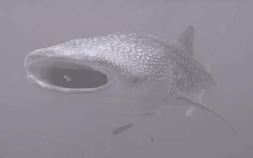
40 Whale sharks (Rhincodon typus) are the largest fish in the world, reaching lengths of more than 12m. They are filter feeders, feeding on plankton, small fish and squid, and occur in both tropical and temperate waters. Normally oceanic and cosmopolitan in their distribution, whale sharks aggregate in the waters of the Ningaloo Marine Park, frequently close to the Ningaloo Reef front, both in the lagoon and outside it, during late March to early June. This aggregation behaviour is only known to occur in a few places in the world. Whale sharks are listed by IUCN as vulnerable and as a listed migratory species under the EPBC Act. Large sharks, such as the oceanic white-tipped shark (Carcharhinus longimanus), and grey reef shark (Carcharhinus amblyrhynchos), and manta rays (Manta birostris) occur in deep water outside the reef and are likely to be found in Commonwealth waters. Manta rays congregate inside the reef as well as in deep water with Ningaloo Reef being an important area for manta rays in autumn and winter (Preen et al. 1997). Numerous other species of rays, small sharks, and juveniles of the larger shark species occur inside the reef, i.e. in State waters (Storrie & Morrison 1998). Whale sharks are listed by IUCN as vulnerable. They are listed as both vulnerable and migratory species under the EPBC Act. Marine Reptiles Marine reptiles in the Marine Park are sea snakes and marine turtles. Of the sea snakes, the olive sea snake (Aipysurus laevis) is most commonly reported. Four species of marine turtle are known to occur in the Marine Park. These are the hawksbill (Eretmochelys imbricata), flatback (Natator depressus), green (Chelonia mydas), and loggerhead turtles (Caretta caretta). The most common turtle in the Marine Park is the green turtle. It is reported to have a high density in Ningaloo Marine Park (Preen et al. 1997). Both green and loggerhead turtles feed in the State waters of the Marine Park and nest on many of the beaches. Under the Commonwealth EPBC Act the green turtle is listed as vulnerable and the loggerhead is listed as endangered. These two species and the hawksbill turtle are listed under the Bonn Convention and as listed migratory species under the EPBC Act. Under the Western Australian Wildlife Conservation Act 1950 the loggerhead turtle is listed as rare. 28 m a n a g e m e n t p l a n
41 Marine Mammals Marine mammals in the Marine Park are dugongs, whales and dolphins. Dugongs (Dugong dugong) occur occasionally in the Commonwealth waters of the Marine Park. However they mostly inhabit the shallow waters fringing the coast and the offshore islands, and in Exmouth Gulf. Whales are a major feature of the Commonwealth waters of the Marine Park. Humpback whales (Megaptera novaeangliae) migrate annually through the Marine Park moving northward to Kimberley breeding grounds in winter (May August) and southward toward summer Antarctic feeding grounds in August November. Both northward and southward migrations occur within 10 to 20 kilometres of the shore, as well as further seaward. Blue whales (Balaenoptera musculus) and sperm whales (Physeter macrocephalus) occur well offshore and may occasionally be observed in the offshore parts of the Commonwealth waters of the Marine Park. Minke whales (Balaenoptera acutorostrata), Bryde s whales (B. edeni) and killer whales (Orcinus orca) have also been observed. The most common species of dolphin occurring in the Marine Park is the bottlenose dolphin (Tursiops truncatus). Other species reported include the Indo-Pacific humpbacked dolphin (Sousa chinensis), common dolphin, (Delphinus delphis), spinner dolphin (Stenella longirostris), spotted dolphin (Stenella attenuata) and Risso s dolphin (Grampus griseus), with many of these species occurring in Commonwealth waters (Storrie and Morrison 1998). Apart from the seasonal migration of humpback whales, most of the whales and dolphins observed in the Marine Park tend to move singly or in small pods and do not congregate in large numbers. Those species of whale and dolphin that, on the basis of their known distributions may occasionally be observed in the Marine Park, are presented in Attachment 6. ningaloo marine park (commonwealth waters) 29
42 While Australian sea lions (Neophoca cinerea) have occasionally been observed in the Marine Park, these would be considered as visitors travelling well north of their normal range. Southern elephant seals (Miroonga leonina) have also been observed in the State waters. Seabirds About 30 species of seabirds are reported to occur on the coastal islands, mainland coastline and offshore waters in the region (CALM 1997, Keeling & Parker 1986, RAOU, 1996 and Storr 1984). These are listed in Attachment 7, with those recorded seaward of the outer reef, and thus likely to occur in Commonwealth waters, indicated. There are no breeding sites within Commonwealth waters. 4.9 Rare, Vulnerable and Endangered Marine Species A number of the species that occur within the Marine Park area have been listed as being in need of protection under State and/or Commonwealth legislation or under international treaties or agreements. Endangered Species (Commonwealth Legislation) Marine fauna of the Ningaloo Marine Park (Commonwealth Waters) listed under the EPBC Act as at 16 July 2000, include three species listed as endangered (blue whale, southern right whale and loggerhead turtle) with the whale shark, three species of turtle and one bird listed as vulnerable (Attachment 8). Rare or Endangered Species (State Legislation) Under the Western Australian Wildlife Conservation Act 1950, fauna in need of special protection is listed in four schedules. Schedule 1 lists species that are rare or likely to become extinct and includes the loggerhead turtle and five species of cetaceans which may be found in both the Commonwealth and State waters (Attachment 9). 30 m a n a g e m e n t p l a n
43 Species Listed Under International Agreements jamba and camba agreements Australia has international obligations that apply within Ningaloo Marine Park for the protection of migratory birds and their habitat as set out in the bilateral agreements between Australia and the Governments of Japan and China (JAMBA and CAMBA respectively). There are 13 species of seabirds which are listed on JAMBA and/or CAMBA which have been recorded seaward of the outer reef and are thus likely to be in Commonwealth waters. These include the whitewinged, bridled and Caspian terns, white-bellied sea-eagle, the wedge-tailed and flesh-footed shearwaters, the brown booby and Wilson s storm-petrel (see Attachment 7). bonn convention Migratory species listed under the Convention on the Conservation of Migratory Species of Wild Animals (Bonn Convention) as at 14 February 2000 that are known or likely to occur within the Ningaloo Marine Park are listed in Attachment 10. Of particular note are the humpback whales, three species of turtle, dugong, osprey and the whale shark. cites Australian species (including species which occur in Australian waters) protected under the Convention on International Trade in Endangered Species of Wild Fauna and Flora (CITES) are listed in schedules 1 to 3 of the Wildlife Protection (Regulation of Exports and Imports) Act Species listed which occur in Ningaloo Marine Park include the blue whale, loggerhead turtle (endangered) and a number of other whales and turtles (see Attachment 10). australia s obligations This Marine Park contributes to meeting Australia s obligations under the CAMBA, JAMBA agreements and Bonn Convention. The management strategies set out in this Management Plan aim to provide as far as possible ongoing protection of those species and their habitats subject to these agreements in the Commonwealth waters of Ningaloo Marine Park. CITES is not affected by the provisions of this Management Plan. ningaloo marine park (commonwealth waters) 31
44 4.10 History Indigenous history and culture The Indigenous cultural values of the Commonwealth waters of Ningaloo Marine Park relate to the long association of Aboriginal people with the coastal waters of parts of the area. Archaeological evidence from the Cape Range peninsula indicates that Aboriginal people inhabited and used the coastal resources of the Ningaloo coast for over 30,000 years. Numerous sites of Aboriginal occupancy have been recorded along the Ningaloo coast, mostly on the western coastal margin rather than in the more inhospitable country inland. These sites include rock shelters near the north-western coastline (Pryzywolnik in prep.) and numerous shell middens known in the coastal dunes. There is evidence of occupation beneath rock overhangs and in caves in the foothills (Morse 1988, 1993a, 1993b). A number of cave sites are known in the Cape Range itself and probably many more have not yet been recorded. Materials collected from the sites indicate that both terrestrial and marine resources were exploited for food (Morse 1988) and decorative ornaments (Morse 1993a). These sites represent the oldest dated evidence for exploitation of marine resources in Australia and provide the earliest evidence for human decorative ornaments in Australia (Morse 1993c). Available evidence points to a long and frequent use of the western coast of the Cape Range peninsula by Aboriginal people during both late Pleistocene and Holocene times (Morse 1993c). It has been argued that some 18,000 years ago, during the arid conditions of the last glacial period, Aboriginal people followed the coastline as it retreated some 10 to 12 kilometres (Morse 1999). The Aboriginal people used coastal resources which have now been inundated with rising sea levels. Ningaloo Marine Park and its hinterland were occupied by two groups of Aboriginal people as documented by Tindale (1974). The Junigudira were located on North West Cape and the Cape Range peninsula to a line between the bottom of Exmouth Gulf and Whaleback Hills. The people were described as coastal inhabitants who used rafts made of sticks. They made use of the resources of the mangroves which archaeological evidence indicates were then more 32 m a n a g e m e n t p l a n
45 extensive on the western coast of Ningaloo Marine Park than they are today (Kendrick and Morse 1982, 1991). They also lived along the eastern shore of Exmouth Gulf. Resources used included fish, shellfish, crabs, crustaceans, sea urchins, turtle, dugong, and flora and fauna associated with the mangrove communities. The territory of the Baiyungu was mapped by Tindale (1974) as the area south of the present settlement of Coral Bay and extending south to Quobba Point. The coastal portions of this area now comprise the southern parts of Ningaloo, Cardabia, Quobba and Warroora Stations. The Aboriginal people had sophisticated, coastally focused subsistence strategies and maintained an extensive trading network. Aboriginal people are variously reported to have left the Cape Range peninsula either prior to European settlement or shortly thereafter, possibly due to the incidence of diseases introduced by whalers or pearlers who operated out of Exmouth Gulf. More recently some of the traditional people have returned to the area. The Baiyungu Aboriginal Corporation has purchased and is managing Cardabia Station, near Coral Bay. The Ningaloo area is now spoken for by the Yamatji Land and Sea Council. Section 359A of the EPBC Act provides that the provisions of the Act and EPBC Regulations relating to Commonwealth reserves do not prevent an Indigenous person from continuing in accordance with law, the traditional use of an area in a Commonwealth reserve for hunting or food-gathering (except for purposes of sale), or ceremonial and religious purposes; although the Regulations do affect traditional use of an area in a Commonwealth reserve if they are made for the purpose of conserving biodiversity in the area, and expressly affect the traditional use of the area by Indigenous persons. The relationship between Aboriginal people and the Commonwealth waters of Ningaloo Marine Park is not known. The whole of the Ningaloo Marine Park is currently subject to an application for a determination of native title under the Native Title Act 1993 on behalf of the Gnulli Native Title Application Group which is comprised of the Ingaarda-Teddei, Baiyungu and Talangi peoples. The claim covers a much greater area than the Marine Park. Section 8 ningaloo marine park (commonwealth waters) 33
46 of the EPBC Act provides that the Act does not affect the operation of the Native Title Act The Commonwealth will respect any native title rights and interests which may exist. European history in the vicinity of the Marine Park The first recorded European contact with North West Cape was a sighting by the crew of the Dutch ship Zeewolf in Later in the same year, the first known landing by a European was made by Captain Jacobz of the ship Mauritius. American whalers operated in the area as early as the 1790s, some 90 years before the land was taken up by Europeans for grazing. Whaling at this time was a ship-based operation and, while it is likely landings were made to acquire fresh water and possibly game, no infrastructure was established on land. The whalers are reported to have initially targeted sperm whales and later, in response to a better understanding of whale migrations, humpback whales. Shore based whaling occurred, for relatively short periods only, at Norwegian Bay and later Point Cloates from 1913 until about 1955, when the Point Cloates station was closed and the men and equipment were transferred to Carnarvon. Between 1936 and 1938 factory ships with chasers operated off the north-west coast, taking a total of 7,240 humpback whales in three years (Chittleborough 1962). Pearling (diving for wild pearl shells) was an activity primarily carried out in Exmouth Gulf and the Rowley Shelf to the east and north of the Marine Park. It is therefore likely that some pearling activity took place in the north-eastern part of the Marine Park. Many of the pearling vessels, or luggers, undertook voyages between Exmouth Gulf and Fremantle. On these voyages a number of vessels were lost along the Ningaloo coast. While there are many shipwrecks recorded in Ningaloo Marine Park and Exmouth Gulf, none of the wrecks occur in the Commonwealth waters of the Marine Park. The pastoral industry commenced with the establishment in 1876 of Minilya Station, which originally encompassed the whole of the Cape Range peninsula. This area was progressively subdivided into the 34 m a n a g e m e n t p l a n
47 present station areas, with Yardie Creek, Ningaloo, Cardabia and Warroora Stations occupying the western coastline. Yardie Creek Station was subsequently acquired by the Western Australian State Government to form part of the Cape Range National Park. In recent years, tourist facilities have gradually developed around the towns of Exmouth and Coral Bay Major Human Uses Much of the human use of Ningaloo Marine Park takes place in the State waters and adjacent land. This includes recreational activities on the reef such as diving and snorkelling, wildlife interaction, and recreational fishing. Current uses of the Commonwealth waters of Ningaloo Marine Park include recreational fishing (including charter fishing), boating (including cruising yachts) and shipping transport. There are a number of oil exploration wells to the north-west of the Marine Park. Limited commercial fishing has been undertaken in the Commonwealth waters. Recreational fishing including charter fishing Recreational fishing is a major activity in Ningaloo Marine Park with an increase in recent years in recreational fishing for billfish (especially sailfish), marlin and tuna. It is estimated that approximately 25 per cent of this activity in Ningaloo Marine Park takes place in the Commonwealth waters. This area is regarded as one of the best in the world for catching small individuals of billfish species. There is a high level of tag and release of billfish and tuna by the game fishing clubs. A survey by Fisheries estimated fishing effort in both Commonwealth waters and State waters of Ningaloo Marine Park from private boats is in the order of 45,000 angler days per annum (Fisheries unpublished data). A review of recreational fishing in the Gascoyne region of Western Australia (Fisheries 1999), of which Ningaloo Marine Park is a part, recognised that there are major management issues with recreational fishing such as increased fishing pressure, both from increased participation and improvements in technology. This has led to some localised depletion of key recreational species. Recreational ningaloo marine park (commonwealth waters) 35
48 fishing has the potential to cause adverse impacts on target and non-target species in Ningaloo Marine Park. Some of the impacts of fishing are discussed in section 5, Pressures on Ningaloo Marine Park (Commonwealth Waters). In 1991 Fisheries imposed additional restrictions on the areas, methods and level of recreational fishing within the State waters of Ningaloo Marine Park. As all fishers in Commonwealth waters will travel through the State waters, those restrictions and possession limits also apply to the fishers in Commonwealth waters. Key recommendations of the Gascoyne region review (Fisheries 1999) included increasing restrictions on recreational fishing, including trip and bag possession limits. Charter fishing operations are considered as recreational fishing and are subject to the restrictions imposed by State regulation. Under amendments to the Western Australian Fish Resources Management Act 1994, all charter fishing operators will require a fishing tour licence from Fisheries. Commercial fishing Historically, commercial fishing has been limited in the Marine Park. Commercial fishing in the vicinity of the Marine Park is managed by the Australian Fisheries Management Authority (Commonwealth) and Fisheries (State). The fisheries operating in the vicinity of Ningaloo Marine Park under Commonwealth jurisdiction are the Western Tuna and Billfish Fishery (WTBF) (long-line fishing) and the Western Deepwater Trawl Fishery (WDTF). The WDTF fishery boundary has a small overlap with the boundary of the Commonwealth waters of the Marine Park. Fish targeted by the WTBF include the migratory yellowfin, bigeye, albacore and skip jack tuna and broadbill swordfish, while the WDTF targets demersal fish. Records indicate there has been little or no trawling in the overlap area of the WDTF and the Marine Park in recent years. The State-managed commercial fishing in the vicinity of the Commonwealth waters includes some wet line and trap and line fishing, for species such as red emperor. Many of these fishers also operate charter fishing businesses in conjunction with commercial 36 m a n a g e m e n t p l a n
49 fishing. For the last 30 years, there has been a condition on all Western Australian State fishing licences prohibiting fishing in the area between Tantabiddi Well in the north and Point Maud in the south, and out to the limit of the Australian Exclusive Economic Zone. Additionally, the waters of the west coast from Shark Bay to North West Cape (including the Commonwealth waters of the Marine Park) are also closed to shark fishing to protect breeding stocks (Simpendorfer and Donohue 1998). The first Management Plan for Ningaloo Marine Park (Commonwealth Waters), which ceased to have effect on 31 December 2000, stated that commercial fishing would be phased out during the course of that Plan and that the second Management Plan will not allow commercial fishing within the Commonwealth waters of the Marine Park. There are currently no permits for commercial fishing in the Commonwealth waters of Ningaloo Marine Park. Tourism Ningaloo Marine Park is a key tourist destination. Recorded visits to the Marine Park and the adjoining Cape Range National Park now exceed 80,000 per annum, having doubled in the last ten years (CALM unpublished data). There is also an increasing number of international visitors, with the presence of the international airport at Exmouth an indication of the popularity of the area for overseas visitors. Most visitors come to the area to experience the coral reef and other natural environments. The main activities undertaken by tourists to Ningaloo Marine Park are snorkelling and diving, recreational fishing, beach recreation and camping, coral and wildlife viewing and wildlife interaction tours. Wildlife interaction tours, which seasonally target whale sharks and whales as well as dugong, manta rays and turtles, provide an opportunity for increased awareness and appreciation of some of the more spectacular wildlife of Ningaloo Marine Park. All of these activities take place in the State waters with recreational fishing, including charter tours, being the only commercial tourism activity currently regularly occurring in the Commonwealth waters. There is ningaloo marine park (commonwealth waters) 37
50 the potential for other commercial activities, such as whale watching tours, to take place in the Commonwealth waters. Petroleum and mineral exploration and production Ningaloo Marine Park is situated in a region that is considered to be prospective for oil and gas production. Offshore exploration activities take place in association with exploration permits to the west and north-west of the Marine Park. A number of exploration wells which recovered or show evidence of petroleum-bearing sequences are located in areas adjacent to the Marine Park. The discovery of oil in the onshore Rough Range No. 1 petroleum exploration well in November 1953 was the first demonstration of the petroleum potential of the region. It was singularly important as the trigger for the widespread search for commercial petroleum reserves in Australia (Johnstone, 1979). The ongoing effort to find additional petroleum resources is likely to view the region as having additional untested potential. Drilling for petroleum exploration and production is not permitted in either the Commonwealth or State waters of Ningaloo Marine Park. In the Commonwealth waters of the Marine Park, no exploration, production or other activity connected with or incidental to the mining or recovery of minerals, including petroleum, is permitted. Potential negative impacts from petroleum and mining activities on the ecological and physical values of the Commonwealth waters are discussed in section 5. There are two petroleum exploration permit areas which are adjacent to and form an incision into the boundaries of the Commonwealth waters of Ningaloo Marine Park (see Figure 1). These are exploration permit areas WA-24-P parts 2 and 3. The NPWC Act did not permit areas covered by existing interests to be proclaimed as part of the Marine Park. It has been the stated intention of the Commonwealth Government that these areas be added to the Marine Park in the event of the exploration permits expiring. Under the EPBC Act, there is now the potential to declare these areas as part of Ningaloo Marine Park (Commonwealth Waters) while the permits are still operational, without affecting any prior usage rights 38 m a n a g e m e n t p l a n
51 as described in section 359 of the EPBC Act. Environment Australia will be liaising with the industry and the Department of Industry, Science and Resources on this issue. Commercial shipping Commercial shipping regularly passes through the Commonwealth waters. Commercial shipping has the potential to discharge polluting substances such as fuel and oils, sewage and other wastes. The discharge of substances from shipping is regulated by the Protection of the Sea (Prevention of Pollution by Ships) Act This legislation is administered by the Australian Maritime Safety Authority (an agency of the Commonwealth Department of Transport and Regional Services). Pollution from the release of operational discharges from ships has gradually decreased in recent years as Australia and other countries enforce restrictions on operational discharges as required by the Convention for the Prevention of Marine Pollution from Ships (MARPOL Convention). Research Due to a number of unique and interesting features, Ningaloo Marine Park and its environments have provided opportunities for research in a number of different fields. The location of the coral reef and the edge of the continental shelf so close to the shore, the regular migration of whales and whale sharks, and the presence of Aboriginal sites all provide opportunities for research. The main areas of research undertaken within Ningaloo Marine Park include: biological and habitat surveys, particularly within the shallow waters of the reef and lagoon; oceanographic studies, in particular of the Leeuwin Current and more recently the Ningaloo Current, and their implications for species distribution and population dynamics within the Marine Park; whale shark population and migration studies; ningaloo marine park (commonwealth waters) 39
52 humpback whale migration pattern studies as part of wider migration studies; coral biology studies, including coral predation, mass spawning and associated de-oxygenation events; surveys of distribution and abundance of the coral-eating snail, Drupella cornus; archaeological studies into Aboriginal occupation and environmental change; and recreational studies. Despite the research that has so far been undertaken, there is still very limited knowledge about many of the values of Ningaloo Marine Park. In particular, there is limited knowledge about the deep water environments including the benthic communities. Education Education is currently a focus of the Marine Park s management. This is achieved through the production and distribution of printed material, interpretative signs, face-to-face contact between visitors and staff, and educational displays. The Milyering Visitor Centre, located adjacent to the State waters of Ningaloo Marine Park in Cape Range National Park, provides a key focus for visitor education and interaction. Scope exists for expanding public and other educational material, for example, covering the geological history of the region and its unique setting which have contributed to the high biodiversity values for which the region has come to be known. 40 m a n a g e m e n t p l a n
, as described in Section 4 (see Table 1).")
53 5. Potential Pressures on Ningaloo Marine Park (Commonwealth Waters) Any natural area subject to human visitation and use is exposed to actual or potential pressures. This section summarises the main human-induced pressures on the key values of Ningaloo Marine Park (Commonwealth Waters), as described in Section 4 (see Table 1). There are also potential pressures from natural disasters, such as tropical cyclones and natural predators, and global phenomena such as increased sea water temperatures. The major potential or current human-induced pressures identified as affecting the physical, ecological, social and cultural values of Ningaloo Marine Park (Commonwealth Waters) include pollution, impacts on target and non-target species from commercial and recreational fishing, and impacts from tourism, introduced species, operations for the exploration and production of petroleum products or minerals, and commercial shipping. TABLE 1: Potential pressures on the major values of Ningaloo Marine Park (Commonwealth Waters) values potential pressures i physical 1. High water quality Pollution: contaminants and marine debris arising from petroleum or mineral exploration and production; aquaculture; fishing oil/chemical spill from shipping accident land based run off ii ecological 1. Diverse marine communities and assemblages including benthic, demersal and pelagic species of invertebrates and fish. Commercial and recreational fishing: reduction in populations habitat modification bycatch and disposal of bycatch Petroleum or mineral exploration and production activities including seismic operations Pollution (see above) Introduced marine pests ningaloo marine park (commonwealth waters) 41
54 TABLE 1 continued Potential pressures on the major values of Ningaloo Marine Park (Commonwealth Waters) values potential pressures ii ecological continued 2. Marine mammals and fish (e.g. whales; dugong; whale sharks) 3. Marine reptiles (e.g. turtles) 4. Sea birds Disturbance from inappropriate tourist/vessel interactions Seismic operations Entanglement with or ingestion of marine debris (e.g. plastics, discarded ropes and fishing line) Collision with ships Oil/chemical spill Commercial fishing (caught as bycatch) Predation of juveniles by feral animals (e.g. foxes) Entanglement with or ingestion of marine debris (e.g. plastic bags, bait straps and fishing line) Disturbance from inappropriate tourist interactions Oil/chemical spill Entanglement with or ingestion of marine debris (e.g. discarded ropes and fishing line.) Commercial fishing (caught as bycatch) Oil/chemical spill Disturbance to roosting from human presence iii social 1. Major destination for recreational fishers 2. Recreational boating and yachting 3. Destination for nature based tourism (e.g. diving/fishing, whale shark/marine life viewing/ interaction tours) Recreational experience potentially affected by: overfishing increased competition for some target fish species (e.g. billfish) crowding at specific sites during peak periods or at major ecological events (e.g. whale migration) reduced water quality (e.g. marine debris) over-regulation Reduced amenity resulting from major oil/chemical spill iv cultural 1. Long association of Aboriginal people with the Ningaloo coastal marine environment including prehistoric coastlines. Activities which break, or perpetuate an existing break, with Aboriginal people s long association with Ningaloo. 42 m a n a g e m e n t p l a n
55 5.1 Commercial and Recreational Fishing Commercial and recreational fishing have the potential for major negative impacts on the marine life of the Commonwealth waters. Some of these include: significantly reducing the distribution and abundance of target species thus changing the population structure; reducing population levels of non-target species through bycatch; major impacts on benthic communities including destruction of flora and fauna, and loss of demersal fish and other fauna through habitat modification (e.g. from trawling); bycatch of sea birds, turtles, dolphins and sharks; interruption of natural ecological balance through large-scale removal of particular species; and increased levels and types of litter which can impact on marine fauna (e.g. through entanglement). Chesson and Clayton (1998), Harris and Ward (1999), Moran et al (1995) and Moran and Stephenson (in press). Most of these impacts are more likely to be associated with commercial fishing due to the scale and nature of activities and, in some cases, the number and types of fish and other species which may be affected. However, very high levels of recreational fishing also have the potential to significantly impact on fish populations and increase levels of litter. Potential impacts of both recreational and commercial fishing are reduced through legislative regulation, educational programs and the implementation of government policies such as the Commonwealth Bycatch Policy (Commonwealth of Australia 2000). 5.2 Petroleum and Mineral Exploration and Production While the petroleum industry in Australia has a generally good environmental record, there is still the potential for damage to the sensitive marine communities from exploration and extraction activities. Some of the potential negative impacts from these activities result from: ningaloo marine park (commonwealth waters) 43
56 accidental discharge of substances (for example, oil, gas or fuel) caused by leakage, spillage, ruptures or blow out; emission of high-energy, low-frequency noise during seismic surveys; discharge of drilling fluids and cuttings; and rig and supply vessel anchors which may disturb bottom sediment or reef structures. Swan et al. (1994). There is evidence that seismic operations which emit high energy, low frequency noise have the potential to cause stress and possible mortality to marine fauna in certain circumstances. Species of particular concern include cetaceans and large migratory fish. McCauley et al. (1998) and McCauley et al. (2000). All petroleum industry activities are subject to assessment and management under Commonwealth and State legislation. A wide range of technical and procedural measures is in place to ensure that activities are conducted in an environmentally responsible manner. 5.3 Tourism While tourism can have very positive influences on the Marine Park in the form of increased awareness among visitors and the community, unless it is managed appropriately it can also have damaging effects. Tourism activities have a potential for negative impacts on the ecological, social and cultural heritage values of the Marine Park. For example, disturbance from inappropriate interactions between tourists and certain large marine fauna may stress the animals. Low flying aircraft may also disturb large marine fauna such as whales. At Ningaloo Marine Park, these impacts are minimised by providing guidelines to commercial operators and individuals for interactions with certain fauna such as whales (ANZECC 2000), whale sharks and turtles (at nesting sites). The Regulations contain provisions for interactions with cetaceans (Part 8) which are consistent with the ANZECC guidelines. While currently there are no commercial wildlife interaction tours in Commonwealth waters, many of the fauna targeted for these tours 44 m a n a g e m e n t p l a n
57 inhabit the Commonwealth waters as well as the State waters and there is the potential for commercial tourism. Other impacts relating to tourism which may affect the Commonwealth waters of Ningaloo Marine Park, such as increased litter and pollution, and impacts relating to recreational fishing, are discussed under the appropriate headings. 5.4 Pollution Pollution from a variety of sources presents one of the major threats to the values of Ningaloo Marine Park. Sources may be either landbased or sea-based. Sources from the land are limited by a number of factors including the low level of run off from the hinterland due to the generally low rainfall and high evaporation rates, and the limited development of the hinterland. Nevertheless, silt laden run off and contaminants from coastal developments such as townships can be significant after periods of heavy rainfall. The impacts are greatest on the State waters. A major oil spill, particularly from shipping, would negatively affect water quality and may cause large-scale mortality of some marine life, depending on the location, dispersal and volatility of the oil product. Based on recent history, the risks of such an event are low, but need to be minimised as the consequences could be great in terms of negative impacts on the social, cultural and recreational values of both State and Commonwealth waters. Pollution which may impact on Commonwealth waters includes: flotsam and jetsam from recreational and commercial uses including fishing (e.g. plastic bags, bait straps and fishing lines) and petroleum related activities; pollution from shore based activities (e.g. sewage); fuel and oil discharges or spills e.g. from vessels (small or large scale); and sewage and other wastes from vessels including commercial shipping and waste associated with petroleum activities. ningaloo marine park (commonwealth waters) 45
58 The potential impacts of pollution include: reduction in the water quality which may negatively impact on marine species and communities in the Marine Park, especially the coral reefs and associated flora and fauna; entanglement of birds, fish and marine mammals and ingestion of marine debris, e.g. plastics, possibly causing death; collision of marine fauna with large flotsam; and mortality of fauna and flora and damage to habitats from an oil or chemical spill. Australia has the capability to respond to spills of oil and chemicals, known as the National Plan to Combat Pollution of the Sea by Oil and Other Noxious and Hazardous Substances. This plan provides a national framework for responding promptly and efficiently to marine pollution incidents. Nevertheless, the sparse population and limited access of the coastline mean that it would be difficult to quickly put in place oil containment or dispersal measures in the event of a large oil spill out to sea. The proposed management strategies of this Plan aim, among other things, to reduce the risk of such a major accident. 5.5 Introduced Species Introduced foxes are known to prey on the eggs and juveniles of green and loggerhead turtles which nest on some of the beaches of Ningaloo Marine Park. While the nesting areas are in the State component of the Marine Park, the fox predation impacts on the populations of turtles that forage in the Commonwealth waters. Introduced marine pests pose a potential threat to the marine communities. One of the main sources of introduced marine pests, the deliberate release of ballast water, is unlikely to occur in the Commonwealth waters. There is also the potential for the introduction of exotic organisms that may become detached from the hull of a cruising yacht while at port or in a lagoon such as Ningaloo. Nationally, there is a range of activities being undertaken to minimise the risk of marine pest incursions through the National Taskforce on the Prevention and Management of Marine Pest 46 m a n a g e m e n t p l a n
59 Incursions, and the development of mandatory requirements for ships to manage their ballast water to avoid the introduction of marine pests which is due to be introduced on 1 July Commercial shipping The Commonwealth waters of Ningaloo Marine Park are used by commercial shipping carrying predominantly domestic freight. There is some international traffic. The main potential impacts from commercial shipping include low level discharge of oil and fuel and possibly sewage and other wastes and noise impacts. The release of flotsam, such as large shipping containers and fuel drums, e.g. during storms, is a potential hazard to large marine fauna and small vessels. A large-scale oil spill from a fuel tanker could result in a significant impact on the marine communities of Ningaloo Marine Park. Under Commonwealth law, all shipping is regulated to minimise impacts from the discharge of wastes, flotsam and oil spills. Nevertheless, the potential threats remain. 5.7 Aircraft Low flying aircraft for either military or civil purposes can have an impact on Marine Park visitors and migrating whales. The EPBC Regulations and the ANZECC Australian National Guidelines for Cetacean Observation (ANZECC 2000) include vertical limits of approach to cetaceans. ningaloo marine park (commonwealth waters) 47
60 6. Managing Ningaloo Marine Park (Commonwealth Waters) This section of the Plan states how the Marine Park is to be managed as required by Section 367 of the EPBC Act. It outlines the management goals and management strategies for the Commonwealth waters of Ningaloo Marine Park. Consistent with the ANZECC best practice model in performance reporting (ANZECC 1997), the management goals and strategies derive from the requirements of the legislation, the strategic objectives for the Marine Park (section 3), and an analysis of the potential pressures on the key values of the Commonwealth waters (section 5). The values and major uses of Ningaloo Marine Park (Commonwealth Waters) are described in section 4. Because of the high degree of ecological interaction between the Commonwealth and State waters components, and the fact that Ningaloo Marine Park encompasses a large marine ecosystem, the management of Ningaloo Marine Park follows a cooperative and ecosystem-based management approach. 6.1 Conservation of Biodiversity The key ecological values of Ningaloo Marine Park (Commonwealth Waters) are the rich and diverse marine communities, assemblages of pelagic and demersal fish. Currently little is known about the benthic communities. There is a regular exchange between the pelagic and demersal systems for feeding and reproduction with a continuous movement of water and animals between the deep ocean and the nearer shore habitats of both the Commonwealth waters and State waters. Of particular note for management purposes are the pelagic and demersal fish, the large marine mammals, marine reptiles and sea birds, including some endangered and vulnerable fauna. The marine benthic flora and fauna of the deep water habitats of the Commonwealth waters are of scientific interest due to the presence of both tropical and temperate influences. These habitats 48 m a n a g e m e n t p l a n
61 have not been systematically studied. Management of the Commonwealth waters would benefit from increased knowledge about the ecosystems and ecosystem processes of these waters including further study into the geological history of ecosystems of the Marine Park that have influenced current ecological processes. The major potential or existing human-induced pressures on the ecological values of the Commonwealth waters include: any activity which negatively impacts on the water quality; fishing activities which impact on populations of fish and non-target species; destruction of habitat by trawling; tourism where there are inappropriate interactions of humans with marine fauna; entanglement in and ingestion of litter; predation or competition from introduced species; and some aspects of exploration and extraction of petroleum and minerals including seismic surveys. Natural processes can also have major effects on the biodiversity of the region. Major natural processes such as periodic cyclones are known to cause the greatest form of local habitat variation and rapid change. Large fragments of living coral reef are known to have been eroded from the living reef and transported several tens of metres inland of the high tide level during major cyclonic storms. Natural cycles promote high levels of biodiversity by producing local environmental heterogeneity (Meffe et al. 1997). Management goals conservation of biodiversity 1. To apply ecosystem-based management to Ningaloo Marine Park. 2. To ensure that the abundance and species diversity of marine communities and ecosystem processes in the Commonwealth waters are not adversely affected by human activities. 3. To promote the maintenance of the high water quality required to sustain the marine communities and habitats of Ningaloo Marine Park. 4. To foster broad community stewardship, and commitment to the protection, of the diverse values of the Marine Park. 5. To increase the knowledge of marine communities and species and key ecological processes in the Commonwealth waters. ningaloo marine park (commonwealth waters) 49
62 Management strategies conservation of biodiversity 1. Work with the Western Australian Government agencies in the integrated planning and management of the Ningaloo Marine Park ecosystem. 2. Restrict and prohibit activities inconsistent with the maintenance of biodiversity, habitat, ecosystem structure and function. 3. Support the improved management of recreational fishing by Fisheries. 4. Provide educational material aimed at promoting an awareness of the ecological values of the Marine Park, promoting community stewardship and reducing the impacts of human users on the marine communities of the Commonwealth waters. 5. Encourage research to increase knowledge of marine species and communities and ecosystem processes. 6. Investigate the possible establishment of sanctuary or no take zones in the Commonwealth waters during the period of this Plan. 6.2 Commercial Fishing Commercial fishing has historically been limited in the Commonwealth waters of Ningaloo Marine Park (see section 4.11). The potential impacts of commercial fishing on the ecological and physical values of the Commonwealth waters are discussed in section 5.1. Subsection 354(1) of the EPBC Act provides that an action must not be taken for commercial purposes in a Commonwealth reserve except in accordance with a management plan for the reserve. This second Management Plan confirms the direction of the first Plan that commercial fishing will no longer be permitted in the Commonwealth waters of Ningaloo Marine Park. Management goals commercial fishing 1. To eliminate the current and potential impacts of commercial fishing on the ecological values of the Commonwealth waters. 50 m a n a g e m e n t p l a n
63 Management strategies commercial fishing 1. Exclude commercial fishing from the Commonwealth waters of Ningaloo Marine Park. 2. In cooperation with AFMA and Fisheries, develop a coordinated compliance and enforcement regime for commercial fishing in Ningaloo Marine Park (Commonwealth Waters). 3. Monitor the incidence of longlines drifting into Ningaloo Marine Park (Commonwealth Waters). In association with the relevant fishing industry associations, AFMA and Fisheries, Environment Australia will develop codes of conduct and procedures for retrieving lines as appropriate. 6.3 Recreational Fishing (including charter fishing) Recreational fishing is a major activity in the Commonwealth waters of Ningaloo Marine Park. Recreational fishing in the Commonwealth waters is mostly for big game fish and is often undertaken via commercial charter tours. As discussed in section 5.1, recreational fishing has the potential to impact on the ecological values of the Marine Park particularly through reducing populations of target and non-target fish species and increasing litter. The EPBC Regulations specify the methods of recreational fishing permitted in protected areas. These include the use of a line and baited hook or lure. Spearfishing is not allowed without a permit from the Director. The Regulations (12.35) give the Director the capacity to make determinations relating to recreational fishing in the Commonwealth waters. The Director will do so if considered necessary during the life of this Plan. Regulation operates subject to s354(1)(a) of the EPBC Act, which prohibits activities in relation to native species (including fish) e.g. killing, injuring or taking; except in accordance with a management plan. Consistent with the strategic objectives, the following management goals and strategies aim to provide appropriate opportunities for recreational fishing while minimising the potential impacts of this activity on the ecological values of the Marine Park. ningaloo marine park (commonwealth waters) 51
64 Management goals recreational fishing 1. To minimise the potential negative impacts of recreational fishing on ecological values in the Commonwealth waters. 2. To allow recreational fishing in the Commonwealth waters consistent with the conservation of the values of the Marine Park. Environment Australia will take a precautionary approach on this issue. 3. To improve individual responsibility and support for sustainable fishing. Management strategies recreational fishing 1. Recreational fishing, including commercial charters for recreational fishing, will be allowed in the Marine Park, in accordance with the provisions of regulation of the EPBC Regulations, including any determinations made by the Director under subregulation 12.35(3). 2. Commercial fishing charter operators will require a permit from the Director. Only those fishers with a current Western Australian licence to undertake commercial charters for recreational fishing in the area will be eligible. 3. Work with Fisheries to reduce impacts of recreational fishers, through restrictions such as bag and possession limits and prohibitions on sale. 4. Support education programs targeting recreational fishers. These will be aimed at reducing the environmental impacts of recreational fishing and promoting community stewardship of fish and the marine environment. 5. In consultation with Fisheries, carry out monitoring of recreational fishing activities in the Commonwealth waters to assess the impacts and sustainability of charter and recreational fishing (e.g. through the use of the log books of charter operators). Should there be indications of significant biodiversity impacts from recreational fishing, Environment Australia will consider further management options which may include appropriate restrictions. 52 m a n a g e m e n t p l a n
65 6.4 Petroleum and Mineral Exploration and Production The North West Shelf, to the north of Ningaloo Marine Park, is a major area for oil and gas production and exploration and the Ningaloo region is considered as prospective. Offshore exploration has been carried out within the Marine Park prior to its establishment and has continued in areas adjacent to it. As described in section 5.2, petroleum exploration and production activities have a potential for negative impacts on the marine environment. The management goals and strategies for petroleum and mineral activities relate to minimising potential impacts on the Commonwealth waters of the Marine Park from activities in the vicinity of the Marine Park. As described in section 4.11, the two petroleum exploration permit areas, WA-24-P parts 2 and 3, which are adjacent to and form an incision into the boundaries of the Commonwealth waters of Ningaloo Marine Park, are being considered for addition to the Marine Park. Consistent with the first Management Plan and the categorisation of Ningaloo Marine Park (Commonwealth Waters) as an IUCN II National Park, mining operations are prohibited within the Marine Park. Management goals petroleum and mineral exploration and production 1. To prevent adverse impacts on the physical, ecological, social and cultural values of the Commonwealth waters from petroleum or mining activities in the vicinity of Ningaloo Marine Park. Management strategies petroleum and mineral exploration and production 1. Maintain the exclusion of petroleum and mineral exploration and production from Commonwealth waters. 2. Continue to liaise with the Department of Industry, Science and Resources concerning the assessment of application permits and exploration release areas in the vicinity of Ningaloo Marine Park. ningaloo marine park (commonwealth waters) 53
66 3. Investigate options for adding the petroleum exploration permit areas WA-24 Parts 2 and 3 to the Commonwealth waters of Ningaloo Marine Park. This would require a proclamation to be made in accordance with the EPBC Act to amend the existing proclamation of the Marine Park. 3.1 If the Proclamation of the Park is amended to include the areas to which petroleum exploration permits WA-24 Parts 2 and 3 relate, and the permits are no longer in force or effect at that time, those areas will be managed in accordance with this Management Plan, including the prohibition on petroleum and mineral exploration and production. 3.2 If the Proclamation of the Park is amended to include the areas to which petroleum exploration permits WA-24 Parts 2 and 3 relate, and the permits are still in force or effect at that time, those areas will be managed in accordance with this Management Plan, including the prohibition on petroleum and mineral exploration and production, but subject to the rights of the holder of permits WA-24 Parts 2 and 3, in accordance with s359 of the EPBC Act. 6.5 Tourism Tourism provides an opportunity for visitors to appreciate the physical, natural and cultural values of the Marine Park. The main commercial tourism activity in the Commonwealth waters is charter fishing. The management goals and strategies for this activity are included in the section on recreational fishing (section 6.3). Wildlife interaction tours currently only occur in the State waters however potential for some tours exists in the Commonwealth waters. The provision of tourism activities needs to be consistent with the strategic objectives of Ningaloo Marine Park (Commonwealth Waters). The management strategies for tourism activities relate to current and possible future tourism activities in the Commonwealth waters and aim to reduce any negative impacts on the ecological values of the Commonwealth waters, in particular large marine fauna. 54 m a n a g e m e n t p l a n
67 As noted in relation to commercial fishing, action must not be taken for commercial purposes in Ningaloo Marine Park (Commonwealth Waters), except in accordance with the Management plan. Should any commercial activity be proposed to take place in the Commonwealth waters in the future, a permit will be required from the Director. The Director will assess such applications taking into account the strategic objectives for the Marine Park and the likely impacts of the proposed activity. Where the activity involves a species that is protected under Part 13 of the EPBC Act, it may also need a permit under Part 13 of the Act. Where there is likely to be a significant impact on such a species, the activity may require assessment and approval under Chapter 4 of the EPBC Act. In addition, the EPBC Regulations specify the parameters for human interaction with cetaceans (whales and dolphins) in Commonwealth marine areas. These are based on the ANZECC Australian National Guidelines for Cetacean Observation (ANZECC 2000). Under the EPBC Act, Regulations may be made to regulate or prohibit the landing and use of aircraft in, and the flying of aircraft over Ningaloo Marine Park (Commonwealth Waters). Management goals tourism 1. To provide for the operation of low impact commercial tourism activities which add to the recreational and educational experience of Marine Park users. 2. To ensure that tourist operations do not negatively impact on the ecological or cultural heritage values of the Marine Park. Management strategies tourism 1. Monitor the location and extent of commercial tour operations in the Commonwealth waters and investigate sustainability levels. 2. Review guidelines for human interaction with large marine fauna. 3. Commercial tourism proposals will be considered on a case by case basis and the activity may be allowed under permit. 4. Liaise with CALM regarding the issue of commercial tour permits as required. ningaloo marine park (commonwealth waters) 55
68 5. Provide educational material and licence conditions to commercial wildlife tour operators aimed at reducing any negative impacts of tourism on the Commonwealth waters. 6.6 Commercial Shipping Commercial shipping has the potential to negatively impact on the ecological, social and cultural values of the Commonwealth waters mainly through pollution. Management goals commercial shipping 1. To reduce potential negative impacts on the values of the Commonwealth waters from discharges from commercial shipping. Management strategies commercial shipping 1. Review the risks posed by commercial shipping to the key values of the Commonwealth waters. 2. Liaise with the WA Department of Transport and the Australian Maritime Safety Authority with the aim of minimising the release of pollutants and wastes from commercial shipping in Ningaloo Marine Park (Commonwealth Waters). 6.7 Pollution Pollution has been identified as a potential threat to the values of Ningaloo Marine Park (see section 5.4). Potential sources of pollution include major oil spills from shipping, low level oil and fuel spills, litter, flotsam and jetsam from recreational and commercial users, and sewage and other wastes from land based sources or vessels. Management goals pollution 1. To reduce potential negative impacts on the values of the Commonwealth waters from potentially polluting activities. 56 m a n a g e m e n t p l a n
69 Management strategies pollution Undertake education and information programs in cooperation with CALM and Fisheries, as appropriate, aimed at: reducing litter which may negatively impact on wildlife and water quality minimising the discharge of sewage and other wastes from recreational and commercial vessels 6.8 Other Commercial Activities As noted previously an action must not be taken for commercial purposes in the Marine Park except in accordance with a management plan. Commercial operations in the Commonwealth waters of Ningaloo Marine Park also require a permit under the EPBC Regulations. The use of Ningaloo Marine Park (Commonwealth Waters) for other commercial purposes will be considered on a caseby-case basis, taking into account the strategic objectives for the Marine Park and the likely impacts of the proposed activity. These may be allowed under permit. 6.9 Indigenous and Non-indigenous Culture The Indigenous cultural values of Ningaloo Marine Park relate to the long association of Aboriginal people with the coastline and resources of the marine environment from prehistoric times. The Baiyungu Aboriginal Corporation have renewed their presence in the area by purchasing and managing the Cardabia Pastoral Lease near Coral Bay. Very few threats to Aboriginal cultural values pertaining to Commonwealth waters have been identified. It is possible that Aboriginal cultural values could be threatened by events causing serious pollution, or by restrictions to Aboriginal access to, and involvement in, the region. ningaloo marine park (commonwealth waters) 57
70 While there are many historic shipwrecks in the State waters of Ningaloo Marine Park, there are no known historic wrecks or other historic or cultural features in the Commonwealth waters. All historic shipwrecks are subject to the provisions of the Historic Shipwrecks Act Should an historic shipwreck be discovered in the Commonwealth waters of Ningaloo Marine Park, the wreck will be managed in accordance with this legislation which is administered by Environment Australia. In the case of State waters, the provisions under the Historic Shipwrecks Act 1976 are mostly delegated to State agencies. Management goals Indigenous cultural heritage 1. To support involvement of Aboriginal people in management of Commonwealth waters as appropriate. Management strategies Indigenous cultural heritage 1. Maintain liaison and consultation with local Aboriginal communities. 2. In consultation with CALM, investigate and support opportunities for involvement of Aboriginal people in the management of the Marine Park. 3. Observe requirements of the Native Title Act Local Aboriginal people will be consulted regarding any use of their cultural knowledge and vocabulary. 5. The Commonwealth will respect any native title rights and interests which may exist Education Education is a major strategy to achieve the management goals and thus the strategic objectives of the Marine Park. Public education is provided through the production and distribution of printed material, face-to-face contact, and educational displays such as at the Milyering Visitor Centre. 58 m a n a g e m e n t p l a n
71 Management goals education 1. To improve public awareness, understanding and appreciation of the marine and coastal environments of Ningaloo Marine Park and of the potential impacts of human activities on these environments. 2. To reduce the negative impacts of human activities on the values of the Marine Park and engender community stewardship of the marine environment through public education. Management strategies education 1. Prepare an education strategy including: Providing information to increase public awareness and appreciation of the natural, physical and cultural values of the Commonwealth waters of Ningaloo Marine Park. Providing information on the potential negative impacts of human activities on the values of Ningaloo Marine Park and ways to minimise these impacts. Utilising the facilities at Milyering Visitor Centre. Providing and distributing information via written material, the Internet and face-to-face contact and investigating other options for the provision of visitor information Research Ningaloo Marine Park provides opportunities for a wide variety of research programs investigating aspects of the coral reef, large marine fauna, ocean currents and cultural and environmental history. Most research activity takes place in the State waters and coastal environments. There are currently large gaps in the knowledge of the marine communities, species and ecosystem processes in Ningaloo Marine Park, particularly in the deeper waters. Improving knowledge of these aspects is critical to improving management of the Marine Park. One of the key gaps in knowledge and research is in the geological origins of the Ningaloo Reef and the emergent flanks of the Cape Range and other anticlines of the region. Another is ningaloo marine park (commonwealth waters) 59
72 knowledge of species and ecosystem processes of the deeper waters and seabed of the continental shelf and slope. Under the EPBC Regulations, carrying out research in the Commonwealth waters of Ningaloo Marine Park requires a permit from the Director. Management goals research 1. To encourage research that will improve knowledge of the values of Ningaloo Marine Park and inform its management. 2. To ensure that information from research is made available to managers of Ningaloo Marine Park. 3. To provide opportunities for research which is of intrinsic benefit to science and humanity, provided these do not impact negatively on the values of the Marine Park. 4. To minimise potential negative impacts from research on the values of Ningaloo Marine Park. Management strategies research 1. Prepare a research plan to include areas of priority research required for management. 2. Develop and implement mechanisms for improving feedback of research results to management. 3. Develop and implement mechanisms to encourage appropriate research at Ningaloo Marine Park. 4. Utilise existing scientific data from a variety of sources such as those generated from previous scientific activities of the petroleum industry. 5. Research which involves the killing, injuring or taking of native species will be assessed on a case by case basis and may be allowed under permit. 60 m a n a g e m e n t p l a n
73 6.11 Compliance and Enforcement Visitors to and users of Ningaloo Marine Park (Commonwealth Waters) are subject to the provisions of the EPBC Regulations and the Management Plan. Under the terms of the Memorandum of Understanding between Environment Australia, CALM and Fisheries, law enforcement in Ningaloo Marine Park (Commonwealth Waters) is primarily carried out by CALM. In the case of fisheries-related activities, enforcement is primarily the responsibility of Fisheries. Relevant officers of each organisation will be considered for appointment as wardens under the EPBC Act. A compliance and enforcement plan will be prepared for Ningaloo Marine Park (Commonwealth Waters) Stakeholder and Community Liaison Ongoing stakeholder and community liaison will be carried out as part of the planning and management of Ningaloo Marine Park (Commonwealth Waters). The Ningaloo Marine Park Management Liaison Committee will be the major forum for regular formal liaison between Environment Australia, CALM and Fisheries. The involvement of the Coral Coast Parks Advisory Committee, based at Exmouth, will be sought as appropriate. As required under the EPBC Act, any proposed amendments to the Plan will involve consultation with stakeholders. ningaloo marine park (commonwealth waters) 61
74 7. Reviewing This Plan 7.1 Performance Assessment A performance assessment framework has been developed in line with the Strategic Plan of Action for the National Representative System of Marine Protected Areas: A Guide for Action by Australian Governments (ANZECC 1999) and Best Practice in Performance Reporting in Natural Resource Management (ANZECC 1997). The performance assessment model for the management of Ningaloo Marine Park (Commonwealth Waters) includes the legislative framework; strategic objectives; analysis of potential pressures on the major values of the Marine Park; management goals; management strategies; and performance measures, targets and monitoring programs. The first elements are dealt with in detail in this Management Plan, particularly in sections 3, 5 and 6. The performance measures, targets and monitoring programs will be further developed from these elements. The performance assessment framework and reports will be produced in consultation with CALM and Fisheries, and will be reviewed annually by the Ningaloo Marine Park Management Liaison Committee. Performance assessment will focus on the effectiveness of the management strategies detailed in this Management Plan, compliance with the provisions of the Plan and the EPBC Regulations, and performance against the Australian Principles for the IUCN Protected Area Management Category II. 7.2 Reviewing the Plan This Management Plan will operate for 7 years. A review of the Plan will be commenced approximately two years before the date of termination. The review will objectively examine the appropriateness of the management prescriptions in the light of any new information concerning the biodiversity, technical advances, environmental safety and the needs of the community. 62 m a n a g e m e n t p l a n
75 Performance assessment will be carried out during the life of this Plan and the results will be used in the development of the next (third) Management Plan for Ningaloo Marine Park (Commonwealth Waters). ningaloo marine park (commonwealth waters) 63
76 8. Bibliography ANZECC (1997). Best Practice in Performance Reporting in Natural Resource Management. Benchmarking and Best Practice Program. Australian and New Zealand Environment and Conservation Council, Working Group on National Parks and Protected Area Management, Canberra. ANZECC (1999). Strategic Plan of Action for the National Representative System of Marine Protected Areas: A Guide for Action by Australian Governments. Australian and New Zealand Environment and Conservation Council, Task Force on Marine Protected Areas, Canberra. ANZECC (2000). Australian National Guidelines for Cetacean Observation and Areas of Special Interest for Cetacean Observation. Australian and New Zealand Environment and Conservation Council, Canberra. Australian Heritage Commission (2000a). Register of the National Estate: Ningaloo Reef Tract, Exmouth WA. Database Number: Registered 21 March Date accessed 5 May Australian Heritage Commission (2000b). Register of the National Estate: Ningaloo Marine Park and Proposed Additions, Exmouth WA. Database Number: Registered 30 May Date accessed 5 May Ayling, A.M. and Ayling, A.L. (1987). Ningaloo Marine Park: Preliminary Fish Density Assessment and Habitat Survey. Report prepared for the Department of Conservation and Land Management by Sea Research, Daintree, Queensland. Boldy, M. (1986). Proposed Ningaloo Marine Park: features of oceanographic interest. Data Report 86/1 for the Australian National Parks & Wildlife Service. Australian Oceanographic Data Centre, Hydrographic Service, RAN, North Sydney. 64 m a n a g e m e n t p l a n
77 Bureau of Meteorology (1999). Climatic Averages. Climate Averages for Exmouth (Vlaming Head). (downloaded from the internet, 10 December 1999). CALM (1989). Parks and Reserves of the Cape Range Peninsula. Part 2: Ningaloo Marine Park (State Waters) Management Plan Management Plan No. 12. Department of Conservation and Land Management, Perth. CALM (1994). A Representative Marine Reserve System for Western Australia. Report of the Marine Parks and Reserves Selection Working Group, Department of Conservation and Land Management, Perth, WA. CALM (1997). Birds of Cape Range National Park and Ningaloo Marine Park: A checklist for bird watchers. Department of Conservation and Land Management, Perth. Carrigy, M.A. and Fairbridge, R.W. (1954). Recent Sedimentation, Physiography and Structure of the Continental Shelves of Western Australia. Journal of the Royal Society of Western Australia. 38: Caton, A., Hearn, B. and Sarti, N. (1988). Southern bluefin tuna research results. Australian Fisheries. 47(5): Chesson J., and Clayton H. (1998). A framework for assessing fisheries with respect to ecologically sustainable development. Bureau of Rural Sciences, Canberra. Chittleborough, R.G. (1962). Recent Whaling: Forward to the second edition. In Dakin, W.J. (ed.). Whalemen Adventurers. Sirius Books, Sydney. Commonwealth of Australia (1998). Australia s Oceans Policy. Environment Australia, Canberra. Commonwealth of Australia (2000). The Commonwealth Policy on Fisheries Bycatch. Agriculture, Fisheries and Forestry Australia, Canberra. Department of Defence (1999). Australian National Tide Tables Australian Hydrographic Publication 11. ningaloo marine park (commonwealth waters) 65
78 Environment Australia (1998a). Draft Recovery Plan for Marine Turtles in Australia. Environment Australia, Canberra. Environment Australia (1998b). Threat Abatement Plan for the Incidental Catch (or By-Catch) of Seabirds during Oceanic Longline Fishing Operations. Environment Australia. Fairbridge, R.W. (1950). Recent and Pleistocene coral reefs of Australia. Journal of Geology. 58(4): Fisheries Western Australia (1999). A Quality Future for Recreational Fishing in the Gascoyne: A Five Year Management Strategy for Recreational Fishing. Proposals for Community Discussion. Fisheries Western Australia, Perth. Gentilli, J. (1978). Physioclimatology of Western Australia. Dept of Geography, University of Western Australia, Nedlands. Godfrey, J.S. and Ridgway, K.R. (1985). The large-scale environment of the poleward-flowing Leeuwin Current, Western Australia: longshore steric height gradients, wind stresses and geostrophic flow. Journal of Physical Oceanography. 15(5): Government of Western Australia. (1994). New Horizons in Marine Management. Government of Western Australia, Perth. Johnstone, M.H., Jones, D.K., Person, G.R., Smith, D.N and Thomas, G.M. (1976). The Phanerozoic of the Perth and Carnarvon Basins, Western Australia. 25th International Geological Congress, Sydney, Excursion Guide 39c. Johnstone, M.H. (1979). A case history of Rough Range. The APEA Journal. 19 (1) 1 6. Harris, A. and Ward, P. (1999). Non-target Species in Australia s Commonwealth Fisheries. A Critical Review. Bureau of Rural Sciences, Canberra. Hatcher, B.G. (1991). Coral Reefs in the Leeuwin Current an ecological perspective. Journal of the Royal Society of Western Australia. 74: m a n a g e m e n t p l a n
79 Hocking, R.M., Williams, S.J., Lavaring, I.H., and Moore, P.S. (1983, Winning Pool-Minilya, Western Australia 1:250,000 Geological Series Explanatory Notes. Sheets SF49 13, SF50 13 International Index. Geological Survey of Western Australia, Perth, Western Australia. Holloway, P.E. and Nye, H.C. (1985). Leeuwin Current and wind distributions on the southern part of the North West Shelf between January 1982 and July Australian Journal of Marine and Freshwater Research. 36: Hutchins, J.B. (1991). Dispersal of Tropical Fishes to Temperate Seas in the Southern Hemisphere. Journal of the Royal Society of Western Australia. 74: Interim Marine and Coastal Regionalisation for Australia Technical Group (1998). Interim Marine and Coastal Regionalisation for Australia: an ecosystem based classification for marine and coastal environments. Version 3.3. Environment Australia, Commonwealth Department of the Environment, Canberra. IUCN Commission on National Parks and Protected Areas (1994). Guidelines for Protected Area Management Categories. IUCN: Gland and Cambridge. Keeling, S. and Parker, I. (1986). An account of a survey of birds utilising the coastal fringe of the Exmouth Peninsula at Coral Bay and between Yardie Creek and Bundegi Reef Western Australia. Report to the Western Australian Department of Conservation and Land Management, Perth. Kendrick, G.W. and Morse, K. (1982). An Aboriginal shell midden deposit from the Warroora coast, north-western Australia. Australian Archaeology. 14: Kendrick, G.W. and Morse K. (1991). Evidence of recent mangrove decline from an archaeological site on the north central coast of Western Australia. Australian Journal of Ecology. 15: Lenanton, R.C., Joll, L., Penn, J. and Jones, K. (1991). The influences of the Leeuwin Current on coastal fisheries in Western Australia. Journal of the Royal Society of Western Australia. 74: ningaloo marine park (commonwealth waters) 67
80 LeProvost Dames & Moore (2000). Ningaloo Marine Park (Commonwealth Waters) Literature Review. LeProvost Dames & Moore, Perth. McCauley, R.D., Jenner, C., Jenner, M-N., McCabe, K.A. and Murdoch, J. (1998). The response of humpback whales (Megaptera novaeangliae) to offshore seismic survey noise: preliminary results of observations about a working seismic vessel and experimental exposures. APPEA Journal pp McCauley, R.D., Fewtrell, J., Duncan, A.J., Jenner, C., Jenner, M-N., Penrose, J.D., Prince, R.I.T., Adhitya, A., Murdoch, J. and McCabe, K.M. (2000). Marine seismic surveys a study of environmental implications. APPEA Journal pp May, R. F, Lenanton, R.C.J. and Berry, P.F. (1993). Ningaloo Marine Park. Report and Recommendations by the Marine Park Working Group, National Parks Authority Report 1, Western Australia. Meffe, G.K., Carroll, C.R., and contributors (1997). Principles of Conservation Biology. 2nd Edition. Sinauer Associates. Sunderland, Mass. 729 pp. Moran, M.J., Jenke, J., Cassells, G. and Nowra, G. (1995). Research for Allocation of North-West Marine Finfish resources among Diverse User Groups. FRDC Final Report: Project no. 91/28, WA Fisheries, Perth. Moran, M.J., and Stephenson, P.C. (in press). Effects of otter trawling on macrobenthos and management of demersal scalefish fisheries on the continental shelf of north-western Australia. ICES Journal of Marine Science. Morse, K. (1988). Mandu Mandu Creek rockshelter: Pleistocene human coastal occupation of North West Cape, Western Australia. Archaeology in Oceania. 23(3): Morse, K. (1993a). Shell Beads from Mandu Mandu Creek rockshelter, Cape Range Peninsula, Western Australia, dated before 30,000 BP. Antiquity. 67: m a n a g e m e n t p l a n
81 Morse, K. (1993b). New radiocarbon dates from North West Cape, Western Australia: a preliminary report. In A. Smith, M. Spriggs and B. Frankhauser (eds.). Sahul in review: Pleistocene archaeology in Australia, New Guinea and Island Melanesia. Canberra, Australian National University. Department of Prehistory. Occasional papers in prehistory No. 24, pp Morse, K. (1993c). Who can see the sea? Prehistoric Aboriginal occupation of the Cape Range peninsula. In Humphreys, W.F. (ed.). The Biogeography of the Cape Range, Western Australia. Records of the Western Australian Museum, No 45. pp Morse, K. (1999). Coastwatch: Pleistocene resource use on the Cape Range peninsula. In Hall, J. and McNiven, I. (eds.). Australian Coastal Archaeology. Research papers in Archaeology and Natural History No. 31. pp Australian National University Canberra. Norman, B.M. (1999). Aspects of the biology and ecotourism industry of the whale shark Rhincodon typus in north-western Australia. MPhil Thesis, Murdoch University, Australia. Pattiaratchi, C.B. and Buchan, S.J. (1991). Implications of long term climate change for the Leeuwin Current. Journal of the Royal Society of Western Australia. 74: Pearce, A. and Cresswell, G. (1985). Ocean Circulation off Western Australia and the Leeuwin Current. CSIRO Division of Oceanography Information Service Sheet. No. 16(3): 1 4. Preen, A.R., Marsh, H., Lawler, I.R., Prince, R.I.T. and Shepherd, R. (1997). Distribution and Abundance of Dugongs, Turtles, Dolphins and Other Megafauna in Shark Bay, Ningaloo Reef and Exmouth Gulf, Western Australia. Wildlife Research, 24(2): Prince, R. (1990). Status of the Western Australian Marine Turtle Populations: The Western Australian Marine Turtle Project In James, R. (1994). (ed.). Proceedings of the Australian Marine Turtle Conservation Workshop 14 17th November Australian Nature Conservation Agency, Canberra. ningaloo marine park (commonwealth waters) 69
82 RAOU (1996). Handbook of Australian, New Zealand and Antarctic Birds. Volume 1. Royal Australasian Ornithologists Union. Oxford University Press, Melbourne. Simpfendorfer, C. and Donohue, K. (1998). Keeping the fish in fish and chips : research and management of the Western Australian shark fishery. Australian Journal of Marine and Freshwater Research. 49: Simpson, C. (1991). Mass spawning of corals on Western Australian reefs and comparisons with the Great Barrier Reef. Journal of the Royal Society of Western Australia. 74: Simpson, C.J. and Masini, R.J. (1986). Tide and Seawater Temperature Data from the Ningaloo Reef Tract, Western Australia, and the Implications for Coral Mass Spawning. Bulletin 253. Western Australian Department of Conservation and Environment, Perth. Steedman Science & Engineering (1991). Metocean Characteristics of Griffin Oilfield Area. Report to BHP Petroleum Pty. Ltd., Melbourne. Storr, G. M. (1984). Birds of the Pilbara Region, Western Australia. Records of the Western Australian Museum, Supplement No. 16. Storrie, A. and Morrison, S. (1998). The Marine Life of Ningaloo Marine Park and Coral Bay. Department of Conservation and Land Management, Perth. Swan, J.M., Neff, J.M., Young, P.C. (1994).(eds.). Environmental Implications of Offshore Oil and Gas Development in Australia The Findings of an Independent Scientific Review. Australian Petroleum Exploration Association, Sydney. Taylor, J.G. and Pearce, A.F. (1999). Ningaloo Reef currents: implications for coral spawn dispersal, zooplankton and whale shark abundance. Journal of the Royal Society of WA. 82(2): Tindale, N.B. (1974). Aboriginal Tribes of Australia: Their Terrain, Environmental Controls, Distribution, Limits, and Proper Names. University of California Press, Berkeley and Los Angeles, California. 70 m a n a g e m e n t p l a n
83 Tucker, M. (1991). Whales and Whale Watching in Australia. Australian National Parks and Wildlife Service, Canberra. United Nations Environment Program /International Union for the Conservation of Nature (1988). Coral Reefs of the World. Volume 2: Red Sea, Indian Ocean and Gulf. UNEP Regional Seas Directories and Bibliographies. IUCN, Gland and Cambridge &UK/UNEP, Nairobi, pp van de Graaff, W.J.E., Denman, P.D., Hocking, R. M. and Baxter, J.L. (1980). Yanrey-Ningaloo, Western Australia 1:250,000 Geological Series Explanatory Notes. Sheets SF49 12, SF50 9 International Index. Geological Survey of Western Australia, Perth, Western Australia. Veeh, H.H., Schwebel, D., van de Graaff, W.J.E. and Denman, R.D. (1979). Uranium-series ages of coralline terrace deposits in Western Australia. Journal of the Geological Society of Australia. 26: Wells, F.E. (1980). The distribution of shallow-water marine prosobranch gastropod molluscs along the coastline of Western Australia. Veliger.22: Western Australian Museum (1988). A feasibility study for the sampling of benthos in the Commonwealth waters of the Ningaloo Marine Park. Report to the Australian National Parks & Wildlife Service by the Western Australian Museum, Perth. Wilkinson, C. R. (ed.) (2000). Status of Coral Reefs of the World: 2000 Global Coral Reef Monitoring Network. Australian Institute of Marine Sciences, Townsville. Wilson, B.R. and Allen, G.R. (1987). Major components and distribution of marine fauna. In Dyne, G.R. and Walton, D.W. (eds.). Fauna of Australia. General Articles. Volume 1A. Australian Government Publishing Service, Canberra, pp ningaloo marine park (commonwealth waters) 71

84 9.Attachments Attachment 1: Information on Figures All figures produced by Environmental Resource Information Network Environment Australia, Commonwealth of Australia, Canberra. COPYRIGHT Commonwealth of Australia July Projection: Geographic Datum: WGS1984 Caveat: data are assumed to be correct as received from the data suppliers. Sources: AUSLIG 2000: Australian Maritime Boundary Information System (AMBIS) data. AUSLIG 2000: Australian Coastline and State Borders. CSIRO Marine Research, Hobart (Figure 2). Schematised from Taylor and Pearce, 1999 (Figure 3). AGSO 1998: GEBCO (15 second) Bathymetry data (Figure 4). 72 m a n a g e m e n t p l a n
TOWARDS SUSTAINABLE MANAGEMENT OF MARINE AND COASTAL HABITATS ASIA- PACIFIC DAY FOR THE OCEAN
 TOWARDS SUSTAINABLE MANAGEMENT OF MARINE AND COASTAL HABITATS WANNAKIAT THUBTHIMSANG PHUKET MARINE BIOLOGICAL CENTER, DMCR, THAILAND ASIA- PACIFIC DAY FOR THE OCEAN 20 NOVEMBER 2018, CONFERENCE ROOM 4,
Title/Name of the area: Chwaka Bay, Zanzibar
 Title/Name of the area: Chwaka Bay, Zanzibar Presented by: Dr. Charles Lugomela, Ag. Head, Department of Aquatic Sciences and Fisheries, University of Dar es Salaam, P.O. Box 35064 Dar es Salaam, Tanzania
Virginian Atlantic (Ecoregion 8)
") Virginian Atlantic (Ecoregion 8) Background The Virginian Atlantic Ecoregion extends from the south side of Cape Cod to Cape Hatteras in North Carolina. The waters of the ecoregion are a mix of cold and
Virginian Atlantic (Ecoregion 8) Background The Virginian Atlantic Ecoregion extends from the south side of Cape Cod to Cape Hatteras in North Carolina. The waters of the ecoregion are a mix of cold and
4) Data sources and reporting ) References at the international level... 5
 Data sources and reporting ) References at the international level... 5") D- 1: Protected areas (PA) 1) General description... 2 1.1) Brief definition... 2 1.2) Units of measurement... 2 1.3) Context...2 2) Relevance for environmental policy... 2 2.1) Purpose... 2 2.2) Issue...
D- 1: Protected areas (PA) 1) General description... 2 1.1) Brief definition... 2 1.2) Units of measurement... 2 1.3) Context...2 2) Relevance for environmental policy... 2 2.1) Purpose... 2 2.2) Issue...
Twelve Apostles Marine National Park Australia
 EVALUATION REPORT Twelve Apostles Marine National Park Australia Location: Victoria, Australia coastal waters Global Ocean Refuge Status: Nominated (2017), Evaluated (2017) MPAtlas.org ID: 7703885 Manager(s):
Kermadec. Ocean Sanctuary
 Kermadec Ocean Sanctuary Kermadec Ocean Sanctuary, New Zealand Pacific Remote Islands National Marine Monument, United States Coral Sea Marine Reserve, Australia Proposed Pitcairn Marine Reserve, United
Alaskan/Fjordland Pacific (Ecoregion 22)
") Alaskan/Fjordland Pacific (Ecoregion 22) Background The Alaskan/Fjordland Pacific Ecoregion is an area of abundant marine resources. The ecoregion begins at Vancouver Island and moves up the Gulf of Alaska
Alaskan/Fjordland Pacific (Ecoregion 22) Background The Alaskan/Fjordland Pacific Ecoregion is an area of abundant marine resources. The ecoregion begins at Vancouver Island and moves up the Gulf of Alaska
How South Africa is making progress towards the Aichi 2020 Target 11
 How South Africa is making progress towards the Aichi 2020 Target 11 Montreal, Canada 2 May 2016 Oceans and Coasts Content Protected area considerations and progress 1994-2010 Terrestrial Protected Area
UNITED NATIONS NATIONS UNIES. United Nations Transitional Administration in East Timor au Timor Oriental UNTAET REGULATION NO.
 UNITED NATIONS NATIONS UNIES United Nations Transitional Administration Administration Transitoire de Nations Unies in East Timor au Timor Oriental UNTAET REGULATION NO. 2000/19 UNTAET/REG/2000/19 30 June
Biosphere Reserves of India : Complete Study Notes
 Biosphere Reserves of India : Complete Study Notes Author : Oliveboard Date : April 7, 2017 Biosphere reserves of India form an important topic for the UPSC CSE preparation. This blog post covers all important
What is an Marine Protected Area?
 Policies, Issues, and Implications of Marine Protected Areas Kara Anlauf University of Idaho Before the House Subcommittee on Fisheries Conservation, Wildlife and Oceans April 29, 2003 What is an Marine
The Regional Coral Reef Task Force and Action plan. 27 th ICRI. Cairns Australia July 2012
 The Regional Coral Reef Task Force and Action plan 27 th ICRI Cairns Australia July 2012 Western Indian Ocean Region East Africa mainland states Indian Ocean Islands states Biogeographic division of the
Conservation Partners for the National Reserve System Program: a Western NSW focus
 Conservation Partners for the National Reserve System Program: a Western NSW focus Cooper, N. 1, Webber, L. 2, Nicolson, K. 3 1 Department of Environment, Climate Change and Water NSW, PO Box 788 Broken
Analysing data on protected areas
 Analysing data on protected areas International goals The OECD is developing an improved method to generate more detailed indicators on protected areas, both terrestrial and marine, for countries across
Status of Antillean Manatees in Belize
 Status of Antillean Manatees in Belize Belize regional stronghold of the Antillean Manatee (Trichechus manatus manatus) Belize population is estimated to be in the region of 800 to 1000 animals Highest
Draft LAW. ON SOME AMENDAMENTS IN THE LAW No.9587, DATED ON THE PROTECTION OF BIODIVERSITY AS AMENDED. Draft 2. Version 1.
 Technical Assistance for Strengthening the Capacity of the Ministry of Environment, Forests and Water Administration in Albania for Law Drafting and Enforcement of National Environmental Legislation A
APPENDIX A TERMS OF DESIGNATION
 247 248 ABOUT THIS DOCUMENT On May 11, 1994 the National Oceanic and Atmospheric Administration (NOAA) published the final Olympic Coast National Marine Sanctuary Regulations (59 FR 24586). This official
Protection of Ulcinj Saline
 Strasbourg, 25 March 2015 T-PVS/Files (2015) 21 [files21e_2015.docx] CONVENTION ON THE CONSERVATION OF EUROPEAN WILDLIFE AND NATURAL HABITATS Standing Committee 35 th meeting Strasbourg, 1-4 December 2015
LATIN AMERICA / CARIBBEAN COIBA NATIONAL PARK PANAMA
 LATIN AMERICA / CARIBBEAN COIBA NATIONAL PARK PANAMA WORLD HERITAGE NOMINATION IUCN TECHNICAL EVALUATION COIBA NATIONAL PARK (PANAMA) ID Nº 1138 Bis Background note: Coiba National Park was nominated for
Order of the Minister of Environment #39, August 22, 2011 Tbilisi
 Registration Code 360050000.22.023.016080 Order of the Minister of Environment #39, August 22, 2011 Tbilisi On preparatory stages and procedure of the methodology for Elaborating structure, content and
We, Ministers, assembled in Berlin for the International Conference on Biodiversity and Tourism from 6 to 8 March 1997
 March 8th, 1997 Berlin Declaration BIOLOGICAL DIVERSITY AND SUSTAINABLE TOURISM We, Ministers, assembled in Berlin for the International Conference on Biodiversity and Tourism from 6 to 8 March 1997 -
Bazaruto Archipelago National Park-Mozambique. Mozambique. Workshop on MPAs- Is MPAs a useful tool In Fisheries management?
 Bazaruto Archipelago National Park-Mozambique Workshop on MPAs- Is MPAs a useful tool In Fisheries management? Norway ; 24-25 25 October 2006 By Paula Santana Afonso Institute for Fisheries Research Mozambique
ENVIRONMENT ACTION PLAN
 ENVIRONMENT ACTION PLAN 2015 16 Airservices Australia 2015 This work is copyright. Apart from any use as permitted under the Copyright Act 1968, no part may be reproduced by any process without prior written
PART 1. EXECUTIVE SUMMARY. English Translation of the Russian Original
 REVISION OF THE PARTIAL SUBMISSION OF THE RUSSIAN FEDERATION TO THE COMMISSION ON THE LIMITS OF THE CONTINENTAL SHELF RELATED TO THE CONTINENTAL SHELF IN THE SEA OF OKHOTSK PART 1. EXECUTIVE SUMMARY English
WORLD HERITAGE NOMINATION - IUCN TECHNICAL EVALUATION EAST RENNELL (SOLOMON ISLANDS)
") WORLD HERITAGE NOMINATION - IUCN TECHNICAL EVALUATION EAST RENNELL (SOLOMON ISLANDS) 1. DOCUMENTATION (i) IUCN/WCMC Data Sheet ( 6 references) (ii) Additional Literature Consulted: Collins, N.M. et. al.
WORLD HERITAGE NOMINATION - IUCN TECHNICAL EVALUATION EAST RENNELL (SOLOMON ISLANDS) 1. DOCUMENTATION (i) IUCN/WCMC Data Sheet ( 6 references) (ii) Additional Literature Consulted: Collins, N.M. et. al.
INFORMATION NOTICE 15-2 Limited & Excluded Lands
 INFORMATION NOTICE 15-2 Limited & Excluded Lands Schedule 1 (Land Description) of onshore petroleum Agreements issued by the Department of Energy details the total hectares calculated. Total hectares are
Forms of Natural Protection in Greece
 Forms of Natural Protection in Greece 105 th Primary School of Thessaloniki NATIONAL PARKS AND PROTECTED AREAS The irregular and constantly increasing human intervention in nature and the relentless exploitation
Adapting to climate change by promoting sustainable livelihoods, human and food security, and resilient ecosystems
 Adapting to climate change by promoting sustainable livelihoods, human and food security, and resilient ecosystems ICRI Indian Ocean Day December 13, 2011 Regional Challenges Atlantic Caribbean Challenge
Marine Protection Rules Part 141 Ship Design, Construction, Equipment and Operation Noxious Liquid Substances in Bulk
 Marine Protection Rules Part 141 Ship Design, Construction, Equipment and Operation Noxious Liquid Substances in Bulk ISBN 978-0-947527-48-8 Published by Maritime New Zealand, PO Box 25620, Wellington
Protected areas. because of the environmental protection that they attempt to provide.
 Protected areas o Protected areas account for most ecoutourism activity because of the environmental protection that they attempt to provide. o The World Conservation Union (IUCN 1994) defines protected
Seychelles Annex VII. National data and information management plan
 Seychelles Annex VII. National data and information management plan TABLE OF CONTENTS 1. National D&I Coordinator and institutional contact details. 2. List of specialists for the national MEDA development.
Maritime Areas Act, 1983 (1)(Act No. 15 of 19 May 1983)
(Act No. 15 of 19 May 1983)") Page 1 Maritime Areas Act, 1983 (1)(Act No. 15 of 19 May 1983) An act to declare the Maritime Areas and for matters incidental thereto and connected therewith. 1. This Act may be cited as the Maritime
Page 1 Maritime Areas Act, 1983 (1)(Act No. 15 of 19 May 1983) An act to declare the Maritime Areas and for matters incidental thereto and connected therewith. 1. This Act may be cited as the Maritime
Ohrid Lake and Prespa Lake, Sub basin s on Crn Drim river basin International Workshop, Sarajevo, Bosna and Hercegovina May 2009
 Ohrid Lake and Prespa Lake, Sub basin s on Crn Drim river basin International Workshop, Sarajevo, Bosna and Hercegovina 18-20 May 2009 Ms. Darinka Jantinska Ministry of Environment and Physical Planning
Palau National Marine Sanctuary Building Palau s future and honoring its past
 A fact sheet from Sept 2015 Palau National Marine Sanctuary Building Palau s future and honoring its past Caring for the environment has long been an important part of Palau s culture. For centuries, traditional
REGIONAL AGREEMENT AND FRAMEWORK FOR MARINE MAMMALS CONSERVATION IN THE WCR: THE SPAW PROTOCOL AND THE MARINE MAMMAL ACTION PLAN
 REGIONAL AGREEMENT AND FRAMEWORK FOR MARINE MAMMALS CONSERVATION IN THE WCR: THE SPAW PROTOCOL AND THE MARINE MAMMAL ACTION PLAN ALESSANDRA VANZELLA-KHOURI SPAW Programme Officer United Nations Environment
Communication and consultation protocol
 Communication and consultation protocol Airservices Australia 2011 This work is copyright. Apart from any use as permitted under the Copyright Act 1968, no part may be reproduced by any process without
photos Department of Environment and Conservation Biodiversity Conservation
 photos Department of Environment and Conservation Biodiversity Conservation EcoEducation - making the connections to biodiversity conservation Do you consider experiential learning of biodiversity in the
CAFNEC Submission to the proposed amendments to the. Plan of Management
 Management Cairns CAFNEC Submission to the proposed amendments to the Cairns Area Plan of Management Please accept this submission on Behalf of the Cairns and Far North Environment Centre. Regards 19 March
Australia s Nature Coast
 Australia s Nature Coast Background A partnership between Fraser Coast Opportunities and Sunshine Coast Destination Ltd has been created to develop and promote the region as one unified, world class ecotourism
Introduces the topic. Diamond shape of whole essay. Diamond shape of each body paragraph
 Academic writing has a particular structure. This structure can be represented like a diamond. The diamond structure repeats on a small level in paragraphs and assignment tasks and on a larger level in
NATIONAL AIRSPACE POLICY OF NEW ZEALAND
 NATIONAL AIRSPACE POLICY OF NEW ZEALAND APRIL 2012 FOREWORD TO NATIONAL AIRSPACE POLICY STATEMENT When the government issued Connecting New Zealand, its policy direction for transport in August 2011, one
Assessing and Protecting the World s Heritage. Assessing and Protecting the World s Heritage
 Assessing and Protecting the World s Heritage NEFA BACKGROUND PAPER Assessing and Protecting the World s Heritage Prepared by: Dailan Pugh, 2014 With the NSW opposition parties threatening to open up the
15/06/2018. Lord Howe Island Marine Park. Moreton Bay Marine Park. Rottnest Island Conservation Reserve WA
 15/06/2018 Lord Howe Island Marine Park Intro Values Management Legislation Core programs Intro A few islands and a few Marine Parks along the way Moreton Bay Marine Park 3400,000ha 2 million people Ramsar
TRANSATLANTIC PLATFORM FOR ACTION ON THE GLOBAL ENVIRONMENT (T-PAGE) 1. Background Paper on US Marine Protected Areas (MPAs)
 1. Background Paper on US Marine Protected Areas (MPAs)") TRANSATLANTIC PLATFORM FOR ACTION ON THE GLOBAL ENVIRONMENT (T-PAGE) 1 Background Paper on US Marine Protected Areas (MPAs) June 2007 Authors: Melanie Nakagawa, Attorney, International Program Kate Wing,
TRANSATLANTIC PLATFORM FOR ACTION ON THE GLOBAL ENVIRONMENT (T-PAGE) 1 Background Paper on US Marine Protected Areas (MPAs) June 2007 Authors: Melanie Nakagawa, Attorney, International Program Kate Wing,
Use of Wetlands for Sustainable Tourism Management
 Use of Wetlands for Sustainable Tourism Management Christine Lim a and Michael McAleer b a School of Tourism and Hotel Management, Griffith University (christine.lim@mailbox.gu.edu.au) b Department of
Wilderness Areas Designated by the White Pine County bill
 Wilderness Areas Designated by the White Pine County bill SEC. 321. SHORT TITLE. This subtitle may be cited as the `Pam White Wilderness Act of 2006'. SEC. 322. FINDINGS. Congress finds that-- The White
Australian Network of Environmental Defender s Offices
 Australian Network of Environmental Defender s Offices Submission on draft Regulation Impact Statement to ban disposal of capital dredge spoil material in the Great Barrier Reef Marine Park 27 March 2015
Proposed National Marine Conservation Area Reserve Southern Strait of Georgia PROJECT UPDATE Spring 2012
 Proposed National Marine Conservation Area Reserve Southern Strait of Georgia PROJECT UPDATE Spring 2012 National marine conservation areas (NMCAs) are established to protect, conserve and present examples
The Senate and the Chamber of Representatives of the Eastern Republic of Uruguay, meeting in general assembly, decree:
 Page 1 Act 17.033 of 20 November 1998 establishing the boundaries of the territorial sea, the adjacent zone, the exclusive economic zone, and the continental shelf The Senate and the Chamber of Representatives
Rule Governing the Designation and Establishment of All-Terrain Vehicle Use Trails on State Land
 Rule Governing the Designation and Establishment of All-Terrain Vehicle Use Trails on State Land 1.0 Authority 1.1 This rule is promulgated pursuant to 23 V.S.A. 3506. Section 3506 (b)(4) states that an
Protecting the Best Places
 United Nations Environment Programme World Conservation Monitoring Centre Protecting the Best Places an international policy perspective Charles Besançon UNEP World Conservation Monitoring Centre Mission
How should the proposed protected area be administered and managed?
 SPERRGEBIET CONSERVATION PLANNING Questionnaire In big words the main objectives of this questionnaire are to contribute to: 1. finding approaches and mechanism for implementing a multi-use protected area
Marine Protection Rules Part 101B: Surveys and Inspections Noxious Liquid Substances Carried in Bulk
 Marine Protection Rules Part 101B: Surveys and Inspections Noxious Liquid Substances Carried in Bulk MNZ Consolidation Marine Protection Rules ISBN 978-0-478-44759-0 Published by Maritime New Zealand,
Continental Divide National Scenic Trail Legislative History and Planning Guidance
 Continental Divide National Scenic Trail Legislative History and Planning Guidance Legislation, Policy, and Direction Regarding National Scenic Trails The National Trails System Act, P.L. 90-543, was passed
Satoquo SEINO (Graduate School of Engineering, Kyushu University, Japan)
") A reconsideration of horseshoe crab conservation methodology in Japan over the last 100 years and prospects for a marine protected area network in Asian seas Satoquo SEINO (Graduate School of Engineering,
A reconsideration of horseshoe crab conservation methodology in Japan over the last 100 years and prospects for a marine protected area network in Asian seas Satoquo SEINO (Graduate School of Engineering,
Draft Resolution on wetlands in polar and subpolar regions
 RAMSAR CONVENTION ON WETLANDS 54th Meeting of the Standing Committee Gland, Switzerland, 23 27 April 2018 Submitted by Sweden Draft Resolution on wetlands in polar and subpolar regions SC54-Com.15 (21.14)
PROUDLY BRINGING YOU CANADA AT ITS BEST. Management Planning Program NEWSLETTER #1 OCTOBER, 2000
 PROUDLY BRINGING YOU CANADA AT ITS BEST VUNTUT NATIONAL PARK Management Planning Program NEWSLETTER #1 OCTOBER, 2000 INTRODUCTION This newsletter launches the development of the first management plan for
VARGAS ISLAND PROVINCIAL PARK
 VARGAS ISLAND PROVINCIAL PARK PURPOSE STATEMENT AND ZONING PLAN February 2003 VARGAS ISLAND PROVINCIAL PARK Purpose Statement and Zoning Plan Primary Role The primary role of Vargas Island Park is to protect
HUT POINT, ROSS ISLAND
 Measure 2 (2005) Annex K Management Plan for Antarctic Specially Protected Area No. 158 HUT POINT, ROSS ISLAND (including Historic Site and Monument No. 18, the historic Discovery hut of Captain R F Scott)
ARTWEI ARTWEI ARTWEI
 Protection / Management Plans for Natura 2000 areas and Maritime Spatial Plan for internal sea waters - including the Szczecin Lagoon Szczecin, 7th May 2011 Andrzej Zych Inspectorate of Coast Protection
Malpelo Fauna and Flora Sanctuary Colombia
 EVALUATION REPORT Malpelo Fauna and Flora Sanctuary Colombia Location: South Pacific Global Ocean Refuge Status: Nominated (2017), Evaluated (2017) MPAtlas.org ID: 3803 Manager(s): Nancy Murillo Bohórquez
The Maltese Islands: Geography
 The Maltese Islands: Geography The Maltese Archipelago comprises a group of small low islands aligned in a NW-SE direction. At their extreme points the Maltese Islands fall within the following points:
Terrestrial Protected Area Nomination: Central Mangrove Wetland South-West, Grand Cayman
 Terrestrial Protected Area Nomination: Central Mangrove Wetland South-West, Grand Cayman The attached nomination, proposing that a parcel of land in the Central Mangrove Wetland be made a Protected Area
Case Study: 1. The Clarence River Catchment
 Case Study: 1. The Clarence River Catchment The NSW coastline is a great natural asset, making an enormous contribution to the economy. The resources of coastal catchments such as the Clarence River Catchment,
 AGREEMENT Between Director of the Białowieża National Park, based in Białowieża (Poland) and Director of the National Park Bialowieża Forest, based in Kamieniuki (Belarus) and Head Forester of the Białowieża
COMMUNICATION AND AWARENESS-RAISING STRATEGY
 MEMORANDUM OF UNDERSTANDING ON THE CONSERVATION OF MIGRATORY SHARKS CMS/Sharks/Outcome 3.5 14 December 2018 3 rd Meeting of the Signatories (Sharks MOS3) Monaco, 10 14 December 2018 COMMUNICATION AND AWARENESS-RAISING
Priority Species, Communities, Ecosystems, and Threats
 Priority Species, Communities, Ecosystems, and Threats East Gippsland Regional Catchment Strategy 2015/2016 1.0 Objective This document aims to assist in the preparation of project applications for 2015-2016
Inquiry into Australia's national parks, conservation reserves and marine protected areas
 Inquiry into Australia's national parks, conservation reserves and marine protected areas 1st March 2006 The Australian Network of Environmental Defender's Offices (ANEDO) consists of nine independently
Thematic Report on Mountain Ecosystems. Please provide the following details on the origin of this report. National Focal Point
 Thematic Report on Mountain Ecosystems Please provide the following details on the origin of this report. Contracting Party: Australia National Focal Point Full name of the institution: Department of the
Aircraft Maintenance Organisations - Certification. Contents
 Contents Rule objective... 3 Extent of consultation... 3 New Zealand Transport Strategy... 4 Summary of submissions... 5 Examination of submissions... 6 Insertion of Amendments... 6 Effective date of rule...
Questions and Answers
 Home The Region Questions & Answers Documents Maps & Imagery Reserve Council Public Comment Search This Site About This Site Questions and Answers 1. Why is the President making this announcement? 2. What
Questions and Answers Cape Town Agreement of 2012
 Questions and Answers Cape Town Agreement of 2012 1. What is the Cape Town Agreement of 2012? The Cape Town Agreement of 2012 (the Agreement) sets internationally agreed minimum standards for the design,
ASIA / PACIFIC NINGALOO COAST AUSTRALIA
 ASIA / PACIFIC NINGALOO COAST AUSTRALIA WORLD HERITAGE NOMINATION IUCN TECHNICAL EVALUATION NINGALOO COAST (AUSTRALIA) ID No. 1369 IUCN RECOMMENDATION TO 35 th SESSION: To inscribe the property under natural
Section 1 Introduction to Sustainable Tourism
 Section 1 Introduction to Sustainable Tourism What is Sustainable Tourism? In defining Sustainable Tourism it is useful to start with an understanding of sustainable development. A term popularised following
Coral Reef status in South Asian Seas Region and its possible restoration partnering with other Agencies
 Coral Reef status in South Asian Seas Region and its possible restoration partnering with other Agencies Dr. Sivaji Patra Senior Programme Officer (Regional) South Asian Seas Programme-SACEP 06 th December,
PROTECTING ANTARCTICA: AN ONGOING EFFORT
 PROTECTING ANTARCTICA: AN ONGOING EFFORT Address by the Minister for Foreign Affairs and Trade, Senator the Hon Gareth Evans QC, to the Opening Session of the 1993 Fenner Conference on a Conservation strategy
Boatswain bay biodiversity reserve
 Boatswain bay biodiversity reserve March 2003 1 1. Plan and description 1.1. Geographic location, boundaries and dimensions The plan of the proposed Boatswain bay biodiversity reserve and its location
Jamaica Member Report
 National Environment and Jamaica Member Report International Coral Reef Initiative 28 th General Meeting October 14-17, 2013 Belize City, Belize Loúreene Jones Coastal and Marine Resources Beaches Wetlands
Access: The rocky shoreline is only accessible via private property.
 10. Whale Cove Site description: Whale Cove is a small cove fringed by private homes and condominiums with diverse and relatively undisturbed rocky intertidal and subtidal habitat located approximately
Queensland s Commitment to the World Heritage Convention
 WORLD HERITAGE LEADERSHIP Queensland s Commitment to the World Heritage Convention The Hon Andrew Powell MP Minister for Environment and Heritage Protection The theme for this symposium Australia s World
Significant Ecological Marine Area Assessment Sheet
 Significant Ecological Marine Area Assessment Sheet Name: Poor Knights Islands Summary: The reef systems of Poor Knights Islands and adjoining reef edges of soft bottom habitat score as a high ranking
UNITED STATES DEPARTMENT OF THE INTERIOR BUREAU OF LAND MANAGEMENT MANUAL TRANSMITTAL SHEET
 Form 1221-2 (June 1969) UNITED STATES DEPARTMENT OF THE INTERIOR BUREAU OF LAND MANAGEMENT MANUAL TRANSMITTAL SHEET Release 8-83 Date Subject 8353 Trail Management Areas Secretarially Designated (Public)
سبل تفعيل تنفيذ ا تفاقية الا راضى الرطبة فى المنطقة العربية
 CONVENTION ON WETLANDS "RAMSAR" AND THE ARAB REGION سبل تفعيل تنفيذ ا تفاقية الا راضى الرطبة فى المنطقة العربية "رامسار" National Institute of Oceanography and Fisheries WETLANDS SERVICES AND PRODUCTS
Tubbataha Reefs Natural Park Philippines
 EVALUATION REPORT Tubbataha Reefs Natural Park Philippines Location: Cagayancillo, Palawan, Philippines; Sulu Sea, Pacific Ocean Global Ocean Refuge Status: Nominated (2017), Evaluated (2017) MPAtlas.org
Northern Pacific Sea Star
 Northern Pacific Sea Star The Northern Pacific Seastar http://www.marine.csiro.au/leafletsfolder/01npseastar.html Reproduced with permission of Craig Macaulay, CSIRO http://www.marine.csiro.au/leafletsfolder/01npseastar.html
European Union Delegation in Albania Organization for Security and Co-operation in Europe Presence in Albania
 The Secretariat of the Convention on the Conservation of European Wildlife and Natural Habitats (Bern Convention). The Secretariat of the Convention on Wetlands of International Importance especially as
MARINE PROTECTED AREA IN MALAYSIA
 MARINE PROTECTED AREA IN MALAYSIA AB RAHIM GOR YAMAN Director, Division of Planning and Management Department of Marine Park Ministry of Natural Resources and Environment abrahim@nre.gov.my History of
Land Management Summary
 photo credit: ANGAIR Anglesea Heath Land Management Summary The Anglesea Heath (6,501 ha) was incorporated into the Great Otway National Park in January 2018. This provides an opportunity to consider the
Bon Portage Island Conservation Campaign
 Bon Portage Island Conservation Campaign Protecting a Coastal Treasure Final Report to Nova Scotia Habitat Conservation Fund September 2012 Protection of Bon Portage Island Over the course of this two-year
SOUTHLAND CONSERVATION BOARD
 SOUTHLAND CONSERVATION BOARD TE ROOPU ATAWHAI O MURIHIKU Secretariat Local Government and Environment Committee Select Committee Office Parliament Buildings WELLINGTON 6011 To the Local Government and
Proposed National Marine Conservation Area Reserve Southern Strait of Georgia PROJECT UPDATE Spring 2012
 Proposed National Marine Conservation Area Reserve Southern Strait of Georgia PROJECT UPDATE Spring 2012 National marine conservation areas (NMCAs) are established to protect, conserve and present examples
The Airport Charges Regulations 2011
 The Airport Charges Regulations 2011 CAA Annual Report 2013 14 CAP 1210 The Airport Charges Regulations 2011 CAA Annual Report 2013 14 Civil Aviation Authority 2014 All rights reserved. Copies of this
chapter fifteen New South Wales marine parks
 chapter fifteen New South Wales marine parks Introduction The New South Wales State government manages the marine area generally out to three nautical miles. The New South Wales system of marine protected
Project Manager, Cairns Airport Land Use Plan Submissions Cairns Airport Pty Ltd PO Box 57 Airport Administration Centre Cairns Airport, QLD, 4870
 Project Manager, Cairns Airport Land Use Plan Submissions Cairns Airport Pty Ltd PO Box 57 Airport Administration Centre Cairns Airport, QLD, 4870 Dear Madam/Sir, The Cairns and Far North Environment Centre
Biosphere Reserve of IRAN. Mehrasa Mehrdadi Department of Environment of IRAN
 Biosphere Reserve of IRAN Mehrasa Mehrdadi Department of Environment of IRAN Biodiversity in Iran Comprises a land area of 1.64 million km² The average altitude is over 1200 m, Is bordered by Turkmenistan,
158 HUT POINT, ROSS ISLAND
 Measure 13 (2015) Management Plan For Antarctic Specially Protected Area No. 158 HUT POINT, ROSS ISLAND (including Historic Site and Monument No. 18, the historic Discovery hut of Captain Robert Falcon
The Regional Coral Reef Task Force and Action plan. Indian Ocean Day. Reunion December 2011
 The Regional Coral Reef Task Force and Action plan Indian Ocean Day Reunion December 2011 Western Indian Ocean Region East Africa mainland states Indian Ocean Islands states Biogeographic division of the
Criteria for the selection of marine and coastal protected areas. Note by the Executive Secretary I. INTRODUCTION
 CBD CONVENTION ON BIOLOGICAL DIVERSITY Distr. GENERAL UNEP/CBD/COP/5/INF/8 20 April 2000 ENGLISH ONLY CONFERENCE OF THE PARTIES TO THE CONVENTION ON BIOLOGICAL DIVERSITY Fifth meeting Nairobi, 15-26 May
Biodiversity and Protected Areas-- Ukraine
 Biodiversity and Protected Areas-- Ukraine EarthTrends Country Profiles Ukraine Europe World Total Land Area (000 ha) 60,370 2,301,873 13,328,979 Protected Areas Extent of Protected Areas by IUCN Category
Malpelo Fauna and Flora Sanctuary Colombia
 EVALUATION REPORT Malpelo Fauna and Flora Sanctuary Colombia Location: South Pacific Global Ocean Refuge Status: Nominated (2017), Evaluated (2017) MPAtlas.org ID: 3803 Manager(s): Paola Andrea Rojas Malagón,