Management Plan. San Salvador National Parks. San Salvador Island, Bahamas BAHAMAS REEF ENVIRONMENT EDUCATIONAL FOUNDATION
|
|
|
- Phillip Clarke
- 6 years ago
- Views:
Transcription


1 San Salvador National Parks San Salvador Island, Bahamas Management Plan 2017 BAHAMAS REEF ENVIRONMENT EDUCATIONAL FOUNDATION Ministry of Agriculture, Marine Resources
2 Cover photo: Sandy Voegeli and Alex Mustard
3 SAN SALVADOR NATIONAL PARKS Management Plan 2017 Bahamas National Trust
4 EECUTIVE SUMMARY The Management Plan for the San Salvador National Parks is intended to provide the longterm vision for the overall management of five national parks for the island of San Salvador, which collectively cover 25,750 acres of marine and freshwater habitats. This plan was an undertaking through numerous partnerships between the Bahamas National Trust (BNT), the San Salvador Living Jewels Foundation, the Gerace Research Centre (GRC) and Global Parks from grant funding from the Critical Ecosystem Partnership Fund (CEPF), and under the Bahamas Protected Project with funding from Oceans 5, through collaborative efforts between The Nature Conservancy (TNC), BNT, and the Bahamas Reef Environment Educational Foundation (BREEF). Activities under both project grants integrated a cooperative and participatory planning process involving the San Salvador Living Jewels Foundation partners, Local Government and the local communities on San Salvador. This plan will balance sustainable traditional uses, facilitate managing invasive alien species, protect areas critical to the survival of the endemic and critically endangered San Salvador Rock Iguana, preserve seabirds nesting habitats with little to no human disturbance, and will encourage the development of an ecotourism sector for San Salvador residents. The plan presents ways to ensure sufficient capacity for effective park management and operations, conserving native species (with particular efforts to endemic and endangered species), natural processes, aesthetics, historical resources, and provide local and international visitors opportunities to explore and appreciate the natural wonders of the complex and unique ecology of San Salvador. The management of the national parks on San Salvador calls for a staff compliment of 8 persons for on-site park management, operations, and to support science programmes and community education and outreach initiatives. Park headquarters will be located in Cockburn Town, where the Parks Administrator, Park Warden, Outreach/ Education Officer, Officer Manager/Financial Clerk and Gift Shop attendant will operate out of, along with a Security Officer. A Science Officer and an additional Park Warden will operate out of a sub-office at or near Graham s Harbour, through a partnership with the Gerace Research Centre. The park units will be managed based on their significance against imminent threats, using management zoning with varying levels of human activity. All parrotfish species within the San Salvador National Parks will be fully protected to promote coral reef resilience, for recovery following elevated sea surface temperature events. Modest development will be done to provide standard park identification signs, a three sided shelter/kiosk, sanitary facilities, a parking area and a dock where appropriate. This plan will require collaborative management with the Department of Physical Planning, the Customs Department, Ministry of Agriculture and Marine Resources, enforcement officers of the Royal Bahamas Defence Force and the Royal Bahamas Police Force, other conservation agencies, and the local communities of San Salvador. The management plan for the San Salvador National Parks covers the following five national parks declared on April 23 rd, 2015: 1. Graham s Harbour Iguana and Seabird National Park 4. Southern Great Lake National Park 2. West Coast Marine Park 5. Green s Bay National Park 3. Pigeon Creek & Snow Bay National Park Photo: Sandy Voegeli
5 White Cay 0 Point of Interest Airport Town Fringe Reef 2 4 Miles Green Cay Catto Cay Hawksnest Cay Gaulin Cay Graham s Harbour Iguana and Seabird National Park Cut Cay Man Cay Km Three Sisters Queen s Highway Gerace Research Center Bonefish Bay Club Med Northwest Arm Lake Long Lake Little Lake Duck Pond Blue Pond Queen s Highway Storr s Lake Crab Cay Chicago Herald Monument Cockburn Town Fernandez Bay Long Bay Columbus Landing Monument Little Lake Southern Great Lake National Park Granny Lake Pigeon Creek Green Bay Goulding Cay Green s Bay National Park Stouts Lake Snow Bay West Coast Marine Park Queen s Highway Snow Bay Nancy Cay Pigeon Creek and Snow Bay National Park French Bay High Cay Sandy Point Middle Cay Low Cay Hinchinbroke Rocks SAN SALVADOR NATIONAL PARKS Bahamas National Trust San Salvador National Parks Management Plan 5
6 TABLE OF CONTENTS EECUTIVE SUMMARY... 4 Introduction... 9 San Salvador Island Overview 9 Geographic Location 10 History of San Salvador National Parks 10 Environmental Importance 13 CRITICAL ISSUES & POTENTIAL THREATS PARK MANAGEMENT PLAN Park Purpose 21 Park Significance 22 Park Mission 22 Vision for the Future 23 PARK MANAGEMENT GOALS AND OBJECTIVES MANAGEMENT ZONING Conservation Zone 31 Sensitive Resource Zone 31 Visitor Services/Park Administration Zone 31 NATIONAL PARK PROFILES AND STRATEGIES Graham s Harbour Iguana and Seabird National Park 33 West Coast Marine Park 36 Pigeon Creek and Snow Bay National Park 39 Southern Great Lake National Park 42 Green s Bay National Park 44 6 San Salvador National Parks Management Plan
7 APPENDICES Appendix A: Relevant National Policies and Legislation Appendix B: References Appendix C: Parks And Protected Areas Selection Criteria With Matrices For San Salvador National Parks SITE NAME: Graham s Harbour/Rice Bay including offshore cays 54 SITE NAME: Pigeon Creek Mangrove Lagoon 55 SITE NAME: Pigeon Creek including offshore cays 56 SITE NAME: Snow Bay 57 SITE NAME: Green s Bay including offshore cays 58 SITE NAME: Great Lake (southern region) 59 APPENDI D: Conservation Targets Appendix E: Estimated Initial And Annual Funding Needs Appendix F: Glossary Appendix G: Community Participation and Input AKNOWLEDGMENTS San Salvador National Parks Management Plan 7

8 Map of The Bahamas highlighting the location of San Salvador Island 8 San Salvador National Parks Management Plan
 lakes.")
9 Introduction San Salvador Island Overview San Salvador is approximately 7 miles wide by 13 miles long, oriented along a north-south axis and bordered by a narrow shelf that has an abrupt shelf-edge break leading to a very steep slope. Nearly a third of the total land area of 91 square miles consists of dune ridges with adjacent troughs forming brackish (hyper saline) lakes. The land is protected by a series of fringing reefs that surround the island with a break in the vicinity of Cockburn Town on the west coast. This breach in the reef allows access to the island for shipping, dockage, and mooring during normal weather patterns. As such, it is extremely difficult for species populations to become naturally re-established from same species populations on neighboring islands. Despite its vulnerability, the natural areas of San Salvador remain relatively untouched. San Salvador is home to the critically endangered San Salvador Rock Iguana, one of the most impressive assemblage of nesting seabirds to be found anywhere in The Bahamas, two (2) Key Biodiversity Areas (KBAs) and exceptional dive sites that attract divers from all over the world. It also is the probable location where Columbus first set foot in the New World. San Salvador National Parks Management Plan 9
10 Geographic Location San Salvador is a small island bordered by a narrow shelf with an abrupt shelf-edge break leading to a very steep slope (along the west side of the island, this slope is known to divers as The Wall ). The island is surrounded by 4,000 meters deep waters and is exposed to waves from the Atlantic Ocean. It is pod shaped with a north-south orientation and measures 11.2 km east-west. Almost sq km of surface area, nearly a third of the total land area, consists of dune ridges with adjacent troughs forming brackish (hypersaline) lakes. A series of fringing reefs surround the island with a break in the vicinity of Cockburn Town on the West Coast. This breach in the reef provides access to the island for shipping, dockage, and mooring during normal weather patterns. The coral reefs form several protected embayments including Graham s Harbour and Rice Bay in the North, Long Bay in the East, Snow Bay and French Bay in the South, and Fernandez Bay and Bonefish Bay in the West. San Salvador is similar in many respects to other islands of the Bahamian Archipelago, but it is unique in its position away from the Bahama Banks. The isolation of San Salvador influences its climate and ecology as well as its cultural history (see Shaklee, 2008; for a discussion of climate and cultural history). This isolation from the Bahamas basin in conjunction with the island s narrow shelf makes the near shore environments extremely vulnerable. It is difficult, if not impossible, for populations of organisms to become re-established from populations existing on surrounding islands. The population replenishment is especially true for fringing and patch reefs which are the cornerstone for San Salvador s diving operations. History of San Salvador National Parks The expansion of the Bahamas National Protected Area System is an undertaking supported by the National Implementation Support Programme (NISP) partners, to advance the Government s commitments under international obligations for the development of a comprehensive and representative system of Protected Areas throughout the archipelago by 2020 (Caribbean Challenge Initiative - org). This commitment has spurred The Bahamas National Trust (BNT) to identify national priority sites of biological, ecological and cultural significance to be added to the National Parks System. This will be done through a systematic approach that involves the participation of local people. The Bahamas National Trust, with support from conservation partner organizations, has long recommended and promoted areas of important marine and terrestrial habitats in and around San Salvador for protection. As early as 1983, sentiments were expressed to protect critical habitats on the island as part of the proposal submitted to the Government of The Bahamas, which recommended that 52 sites be designated as National Parks under mandate by BNT. Notably, scientists consider San Salvador to be the most studied island in The Bahamian Archipelago. This is primarily due to the presence of the Gerace Research Center (GRC), which since 1971 has hosted thousands of international research scientists who have generated copious data on the natural and cultural history of the island. This data has been very useful in promoting and justifying the establishment of San Salvador National Park. Appendix B of this document is a partial compilation of publications that provided support data for the establishment of San Salvador National Parks. In 2000, the Iguana Specialist Group (ISG) of the World Conservation Union (IUCN) held an iguana and seabird workshop on San Salvador. An outcome of this workshop was a document which, among the 26 sites 10 San Salvador National Parks Management Plan

11 Photo: Sharrah Moss considered in the Bahamas, ranked Graham s Harbour as the highest priority site for protection of iguanas and seabirds. Inland Lakes ranked seventh, while the East and South shore and cays came in seventeenth. In 2005, the Bahamas National Trust and the San Salvador Living Jewels (SSLJ) Foundation embarked on an educational campaign to engage the communities of San Salvador in the development of a national park proposal. In February 2007, The BNT submitted to the Government of the Bahamas, a proposal for a San Salvador National Park system that incorporated five (5) sites for consideration. However, delays ensued that were later attributed to private land holding concerns. In 2006, BREEF started an annual summer Sea Camp for children of San Salvador. This was carried out with the support of the Gerace Research Centre and the San Salvador Living Jewels Foundation, and involves over 35 children between the ages of 8-14 each year. Key Sea Camp themes include fisheries, shark conservation, sea turtles, coral reefs and Marine Protected Areas, with field study excursions to teach students about the value of critical areas such as Graham s Harbour, the West Coast Dive Sites and Pigeon Creek. In 2012, the Sea Campers collected petition signatures and created a video to advocate for the establishment of national parks on San Salvador. In 2012, The Bahamas National Trust made it a priority to seek funding to rebuild the momentum of advancing San Salvador s National Park System through implementation of extensive education and outreach initiatives. The Critical Ecosystems Partnership Fund (CEPF) provided funding to advance park designations and management plan development. The goal of this effort was to establish a San Salvador National Park comprised of several separate national park units, to develop a park management plan to ensure that effective management prescriptions are put in place, and to assist The Bahamas in meeting the Government s 2020 Declaration to meet the obligation under the Caribbean Challenge Initiative. San Salvador National Parks Management Plan 11
12 In April 2014, BNT submitted a San Salvador National Park proposal that was based on scientific data, previous planning efforts, and fully considered community stakeholder interests. The proposal was fully endorsed by the people of San Salvador, the San Salvador Living Jewels Foundation, The Nature Conservancy (TNC), BEST Commission, The Department of Marine Resources, The Bahamas Reef Environment Educational Foundation (BREEF), other conservation partners, and a host of international supporters. On April 23rd, 2015, The Deputy Prime Minister of The Bahamas and Member of Parliament for San Salvador, The Hon. Philip Brave Davis, announced the declaration of five (5) new national parks on and around the island of San Salvador, during a Park Announcement Reception on Almond Tree Park in Cockburn Town, San Salvador. A host of dignitaries and spectators gathered on this momentous occasion, including The Hon. Kenred Dorsett, Minister of Environment & Housing, Philip Smith, Former Member of Parliament for San Salvador, representatives from Local Government, the Bahamas National Trust, The Nature Conservancy, BREEF, and numerous residents of San Salvador. The National Park units are limited to marine and freshwater environments, and crown owned islands (cays) within the park boundaries. It was based on the clear need to provide park status as a proactive measure to prevent the degradation of the marine and freshwater environment and cays due to inappropriate use, upland development and anthropogenic pressures. The five sites declared were: Graham s Harbour Iguana and Seabird National Park - Size 5,723 acres West Coast Marine Park - Size 10,313 acres Pigeon Creek & Snow Bay National Park - Size 5,060 acres Southern Great Lake National Park - Size 4,068 acres Green s Bay National Park - Size 586 acres 12 San Salvador National Parks Management Plan
 exists on exposed limestone rock. Sea oats (Uniola paniculata) dominate the dune system in areas that have sand substrate.")

13 Environmental Importance San Salvador s Vegetation Coastal Along the shoreline there are two vegetation community types based on substrate. Shrubland/rocky shore (Rhachicallis americana) exists on exposed limestone rock. Sea oats (Uniola paniculata) dominate the dune system in areas that have sand substrate. Nearshore The nearshore vegetation is located farther inland where it is more protected from salt spray. The coastal coppice community inland from the rocky shore occurs on limestone and typically includes a variety of broadleaf evergreen species. Areas inland from the dune system may be dominated by silver thatch palm and occur on a sand substrate. Interior The interior vegetation includes a variety of saline and fresh water wetlands and upland coppice. Mangroves line the inland brackish lakes and are also found in protected areas of the coastline (French Bay) and estuaries such as Pigeon Creek. The height of the mangroves can be up to four (4) meters. There are also sparsely vegetated flats with plants growing out of cracks in the rocks or in pits where soil has collected with an average shrub height less than 0.5 m. The upland areas have the most extensive and diverse plant community on the island. It is similar to the coastal coppice but with taller vegetation (up to seven (7) meters). The vegetation occurs in areas of exposed limestone with large pockets of dark fertile soils. This community is characterized as having a wide variety of broadleaf evergreen species with no one species being dominant. Areas that have remained relatively untouched in recent years by human presence have high numbers of orchids and bromeliads. Lignan vitae Photo: Sandy Voegeli Native orchid Photo: Sandy Voegeli San Salvador s Birds The offshore cays, main island bluffs, and interior lakes of San Salvador support some of the largest breeding colonies of seabirds to be found anywhere in The Bahamas. Remarkably, San Salvador hosts 14 of the 17 (or 82%) seabird species that breed in The Bahamas. This is the largest diversity of breeding seabirds anywhere in The Bahamas. Eight (8) of these species are of special concern because of declining numbers in the West Indies region, and their vulnerability to extinction. For some species, such as the Audubon s Shearwater and Doublecrested Cormorant, a significant percentage of the entire West Indies population breeds on San Salvador. San Salvador National Parks Management Plan 13

14 Frigate birds Photo: Dr. William Hayes The fragility of San Salvador s seabird populations can be better appreciated from a broader perspective. Globally, seabirds are declining at an alarming rate. Approximately 20% of the world s seabird species are threatened by extinction. The loss of seabirds on tropical islands due to human disturbance has been estimated at a staggering 90 to 99%. In addition to the seabirds, San Salvador is home to the critically endangered West Indian Woodpecker. The West Indian Woodpecker (Melanerpes superciliaris) occupies six (6) major Caribbean islands, representing a highly disjunctive distribution. Each island population in The Bahamas is generally recognized as a distinct subspecies. These populations are restricted to the islands of San Salvador and Abaco. The woodpecker is considered rare on San Salvador Island, and is one of the rarest woodpecker populations in the Caribbean (for more information regarding the birds of San Salvador, see Cummins et al and White, 1998). San Salvador Rock Iguana (Cyclura rileyi rileyi) San Salvador is home to one (1) of the seven (7) sub-species of Bahamian rock iguanas, which make up the three (3) West Indian rock iguana species (genus Cyclura), that are endemic to The Bahamas. All Bahamian rock iguanas are highly endangered and protected by Bahamian Law (Wild Animals Protection Act) and by international law under the Convention of International Trade of Endangered Species (CITES). We know from the fossil record that the main island of San Salvador was once teeming with iguanas. As the largest terrestrial vertebrates in The Bahamas, iguanas contribute to the uniqueness and health of Bahamian ecosystems. Iguanas are found elsewhere in The Bahamas, but those on San Salvador are unique as they have no other home in the world. At present, less than 600 iguanas likely remain, and these are now restricted to a mere fraction (0.2%) of their former range (Hayes et al., 1995, 2004). They are essentially confined to the most remote and inaccessible places available: four (4) tiny offshore cays and two (2) small islets within the hypersaline lakes (31.5 ha total). Other Reptiles San Salvador is home to five (5) other species of native reptiles, including the very rare Wormsnake (Leptotyphlops columbi). This is an endemic species to San Salvador. 14 San Salvador National Parks Management Plan

15 San Salvador Rock Iguanas Photo: Christian Dimitrius San Salvador National Parks Management Plan 15


16 San Salvador s Coral Reef System San Salvador offers a wealth of attractions to the visiting diver. The island has shallow reefs and breathtaking wall dives first discovered by scuba divers in the 1970s. The waters are remarkably clear, with typical visibility of 100 to 150 feet, and more than 20 miles of dramatic vertical walls, beginning at a depth as low as 40 feet. Divers have been thrilled with encounters of grouper, hawksbill turtles, hammerhead and other species of sharks, spotted eagle rays, dolphins and whales. San Salvador s reefs have been studied since the early 1970 s and a wealth of information exists about both their present and past condition/health (see for example McGrath and Smith, 2003; McGrath et al. 2007; and Peckol et al. 2001). The first coral to be listed as an endangered species, Acropora palmata, more commonly known as elkhorn coral, is found in numerous reef locations around San Salvador. Occurrence of the coral hybrid, Acropora prolifera, a cross between Acropera palmata and Acropera cervicornis, was confirmed to also occur in San Salvador s marine environment. Elkhorn Coral Photo: Sandy Voegeli Coral Hybrid Photo: Sandy Voegeli 16 San Salvador National Parks Management Plan

17 Photo: Dr. William Hayes CRITICAL ISSUES & POTENTIAL THREATS Management planning focuses on identifying and developing strategies to solve problems. This plan identifies and addresses the key issues and existing and potential threats relative to the San Salvador National Parks that were identified in the planning process. Additionally, this plan recommends zoning, water craft size and speed limits, sensitive species protection, resource monitoring and other actions to appropriately manage these issues. In implementing this plan, constructive and on-going dialogue will be necessary among all stakeholders to find mutually supported limits and uses that are consistent with the purposes of each park. Climate Change & Natural Disasters The impacts of climate change are already being experienced, and will continue for years to come. Increased intensity of storms, sea level rise, elevated sea surface temperatures and ocean acidification are a reality we are facing today, that will affect San Salvador s natural and cultural resources and beyond. The BNT is committed to integrating climate change adaptation into national park management, and actions will be included in this plan and will be ongoing to mitigate impacts to a changing climate. One of the first steps in addressing climate change for the San Salvador National Parks, will be to prohibit the harvesting on all species of parrotfish and sea urchins, as they are critical to reef recovery following mass bleaching events caused by elevated water temperatures. Parrotfish are herbivores, and are therefore of ecological importance in controlling algae growth on coral reefs. Other actions will be considered in the Climate Change Action Plan for National Parks and Protected Areas managed by the Bahamas National Trust, including developing strategies for monitoring for coral reef resiliency, developing a bleaching response plan, and responding to mass bleaching events. San Salvador National Parks Management Plan 17
18 Watercraft Disturbances from Tour and Dive Operators Watercraft provide the basic means by which consumptive and non-consumptive park users access and use of the parks. Properly used, watercraft and preserving natural resources can co-exist. Inappropriate speeds and noises can cause significant impact to breeding birds, turtles and fish. Solving this problem calls for collaborative and continuing communication between all users. Zoning for various types of watercraft and speed limits are necessary and are proposed in this plan. Disturbance of Wildlife Visitors, including tourists, scientists and students can pose a threat to nesting seabirds, sea turtles and iguanas. Access to crown owned cays will be limited and all students groups and researchers planning to enter sensitive areas closed to tourists, will be required to have a permit describing what they may and may not do. Iguana Feeding Feeding iguanas presents the potential for altering their natural behavior. National park regulations will emphasize that this activity is not permitted, and education and outreach efforts should include language and messages to provide knowledge on the importance of protected endemic iguanas found on the cays located within national park boundaries. Commercial Fishing vs. Recreational Activities Several of the national parks in San Salvador provide both traditional and commercial fishing as well as non-consumptive tourist related activities (diving and snorkeling). Collaboration between all stakeholders is critical. In this plan, sensitive areas are identified to ban consumptive uses. Wildlife Trafficking While endemic Bahamian iguanas are protected by Bahamian and international laws, they are subject to smuggling operations driven by the demand for rare and protected species. The recent smuggling of 13 endangered iguanas out of the country accentuates the need for conservation intervention. Establishing San Salvador National Parks with a focus on protecting the remaining San Salvador Rock Iguanas and their habitat is an important step in protecting this endangered species. Recreational Uses of Pigeon Creek Conflicts between unregulated powerboats (especially jet skis) and non-motorized crafts such as kayaks and canoes create visitor safety issues and aesthetic conflicts between users. This plan will recommend zoning and the active participation of tour operators in planning and monitoring national park areas. 18 San Salvador National Parks Management Plan
19 Overfishing & Illegal Fishing Practices During stakeholder consultations, concerns were raised regarding commercial fishing from visiting boaters and issues related to illegal resource harvest by tour operators in the park areas. Illegal fishing practices must be controlled. National park status will facilitate this through aggressive patrolling and enforcement, in conjunction with local enforcement agencies on San Salvador. Invasive Alien Species Invasive Lionfish (Pterois sp.) are already established in The Bahamas, and have been observed on reef sites. Plans to control and monitor Lionfish populations will be adopted from existing national strategies and in coordination with local partnerships. Assessments on the distribution of other invasive species (plant and animals) may be facilitated through the Gerace Research Center. Incompatible Development Of Adjoining Lands With increased interest in the development of private lands adjoining the national parks on San Salvador, there is a potential threat to the biological and aesthetic integrity of the parks. BNT will work with The BEST Commission, Department of Physical Planning and other relevant Government Agencies, to ensure that development does not provide a threat to the purpose of the parks. Anchor Damage Lack of knowledge and experience by recreational boaters increases the likelihood for damage to marine communities. Physical contact to marine habitats by anchoring causes damages to reefs and other benthic habitats (i.e. seagrass beds), and management measures will be implemented to safeguard against anchor damage through installing mooring buoys and instituting no anchor zones. Boat Maintenance/Hull Cleaning Pollutants generated from boat hull maintenance and cleaning may impair water quality and threaten the health of marine ecosystems. The discharge of toxic substances into Marine Park waters can directly or indirectly negatively impact marine life in a number of ways, and as such, is generally considered undesirable. While Graham s Harbour has been the most practical location for this practice, The BNT and SSLJ partners will work with local dive boat companies to locate a new site for hull maintenance. In the interim, this practice will be allowed under a permitting system, and guidelines will be developed in collaboration with the Department of Environmental Health Services (DEHS) to ensure the integrity of park resources remain intact. Bioprospecting Like the rest of the world, the San Salvador national parks are home to a vast array of biological diversity, which harbors an astonishing assortment of different chemicals for differing adaptation purposes. As island communities in The Bahamas have known for some time, many of these compounds found in the environment have medicinal and other useful properties. This knowledge is also known by scientists, San Salvador National Parks Management Plan 19
20 researchers and pharmaceutical companies, who seek to find new discoveries for profitable gains and it is the exploration of compounds in the species that they encounter that we refer to as bioprospecting. Throughout history, bioprospecting and the resulting economic gains have been benefiting the research and development companies with little benefit to the host country or the indigenous people who have shared their culturally inherited knowledge about their environment. This is also true for The Bahamas, where a gorgonian coral known as Sea Plume (Pseudopterogorgia elisabethae), was discovered to possess compounds with anti-inflammatory properties and became targeted by the cosmetic industry; and subsequently is harvested extensively in the country for commercial gains. The greatest concern is that many companies patent these compounds; often do not disclose where the compound originated; and keep their research highly classified. It has been recognized by the international community that there is a great need for ensuring that the host country and the local communities benefit from their natural resources and traditional knowledge of their beneficial properties. The United Nations Convention on Biological Diversity (CBD) is the principal international regulatory body that speaks to bioprospecting, which was ratified in This convention not only recognizes each country s sovereign control over its own genetic resources but more importantly, gives countries like The Bahamas leverage for negotiating the terms of extracting biological resources and specifically calls for the shared benefit from any information or economic gains; referred to as Access and Benefits Sharing (ABS). However, many countries that are signatory to the CBD, have yet to develop and enforce a policy for ABS; including The Bahamas. The national parks of San Salvador have extensive populations of economically important organisms including the highly sought-after Sea Plume. All bioprospecting and resultant harvesting activities will be strictly prohibited within the national park boundaries until The Bahamas finalizes its national policy on ABS. After which, The BNT will develop specific management guidelines that align with the national policy but also to the objectives of each national park. 20 San Salvador National Parks Management Plan

21 Photo: Sandy Voegeli PARK MANAGEMENT PLAN Every national park unit needs a plan that provides clear guidance about how natural and cultural resources, visitor use, educational programmes, community relations, and park administration will be managed. Planning is a process by which policy is placed into a structure that enables implementation. A management plan is a tool that describes how a park is to be protected, used, developed and managed. It represents the desired future state or condition of the park and the most efficient path to that future. The purpose of this Management Plan, for the San Salvador National Parks, is to provide the necessary tools for park administrators and staff to implement the purpose, vision, management goals and objectives established for the park. This plan addresses key issues and concerns related to consumptive and non-consumptive uses, visitor access to the parks, protection of rare and endangered species and sensitive habitats, the care of significant cultural features and educational programmes. The plan also addresses goals and objectives relating to zoning, sustainable tourism, administrative development, staffing and equipment needs. Park Purpose The park purpose reaffirms the reasons the park was set aside for protection. The purposes of San Salvador National Park include: To protect and manage the national and internationally important natural and cultural resources associated with San Salvador. San Salvador National Parks Management Plan 21
22 In collaboration with local residents, the San Salvador Living Jewels Foundation, the Gerace Research Center, and off island partners, manage park resources in a way that sustainably accommodates traditional uses and life styles. Provide opportunities for Bahamians and foreign visitors to experience and enjoy the park s natural and cultural features in a sustainable way. Encourage scientists from around the world to study and monitor the parks natural resources. Develops educational opportunities and programmes for island residents and visitors. Protect the endemic and all other native species that represent the unique biodiversity of the park. Protect the natural beauty and aesthetic value of the relatively unaltered ecosystems for present and future generations Park Significance San Salvador has a known and well studied wealth of natural, cultural and historical resources that are recognized around the world. San Salvador is similar in many respects to other islands of the Bahamian Archipelago, except that it is located outside the Bahamas Banks. The isolation of San Salvador influences its climate, ecology and cultural history. Moreover, this isolation in conjunction with the island s narrow shelf makes the near shore environment extremely vulnerable to anthropogenic influences. As such, it is extremely difficult for species populations to become naturally reestablished from same species populations on neighboring islands. But despite its vulnerability, the natural areas of San Salvador remain relatively untouched Key features include: the critically endangered San Salvador Rock Iguana, the largest diversity of breeding seabirds in the Bahamas, the only tidal mangrove creek on San Salvador, including a critical mangrove system and nursery area for the Nassau grouper, Queen conch and Spiny Lobster, the internationally important coral reefs and associated subsurface geomorphology, San Salvador is the probable location where Columbus first set foot in the New World. Two (2) of the national park sites, Graham s Harbour and Southern Great Lake, are classified as Key Biodiversity Areas (KBAs), which are sites identified nationally with global significance, supported by the International Union for the Conservation of Nature (IUCN), Birdlife International, Conservation International (CI), the Critical Ecosystem Partnership Fund (CEPF), and other conservation international organizations. Park Mission The mission is to protect a complex of world class marine and freshwater environments, that makes provisions for a sustainable level of human use that educates, inspires and develops an appreciation of these unique resources 22 San Salvador National Parks Management Plan

23 Vision for the Future The park vision is a set of conditions to strive for upon the completion of the objectives identified in this plan. The plan calls for actions that can make this vision a reality. The San Salvador National Parks will: Protect the biological integrity and ecological processes that support the unique marine and freshwater resources, cay habitat and associated terrestrial life for the use and enjoyment of future generations. Become a vital element within the Bahamian National Park System. Be a source of enjoyment, inspiration, pride and education for the residents of San Salvador, other Bahamians islands, and international visitors. Provide positive and sustainable economic opportunities to the residents of San Salvador. Continue to provide opportunities for sustainable traditional uses among local residents. Continue to be an important resource for research projects involving Bahamian and international scientists. Provide park infrastructure that facilitates visitor information, education, interpretation, and administrative offices. Be managed to enable the San Salvador Living Jewels Foundation, Gerace Research Center, other local groups and individuals to feel an ownership of the park, and be engaged as partners, advisors and supporters. Photo: Christian Dimitrius San Salvador National Parks Management Plan 23

24 Photo: Sandy Voegeli PARK MANAGEMENT GOALS AND OBJECTIVES Defining goals and objectives is the first step, and one of the most important steps in the management planning process. Goals are defined here as the broadly stated primary purposes for which the San Salvador National Parks were established. They identify WHAT we want to achieve. Objectives are the more explicit statements of how the goals will be accomplished. They also identify HOW we are going to get there. In all cases, the goals and objectives must be consistent with the language and intent of the fundamental purpose of the park, as reflected in the legislation or decree establishing it. The following goals and objectives apply to all of the park units in San Salvador National Park. Strategies specific to each national park unit will be described in the Section VI of this plan. Goal # 1: Ensure sufficient capacity for effective park management and operations Objectives Park Administration Staffing requirements include 8 individuals who will manage the Island s five National Parks. Park staff include a Parks Administrator who will oversee overall BNT operations on San Salvador, including concession and permit management, and two Deputy Park Wardens who will carry out a range of duties relative to general park maintenance, patrolling, resource protection, signage installation, trail development and infrastructure maintenance. An Office Manager/Financial Clerk will support Parks and office operations, and an Education Officer will be in charge of interpretation, and implementing community outreach and educational programmes. A Science Officer will implement a scientific monitoring programme within park units, and will work along with visiting researchers and professors to assist in such activities. A Gift Shop Attendant 24 San Salvador National Parks Management Plan
25 will manage the sales of BNT merchandises and other inventory, and a Security Officer will be stationed at Park Headquarters to ensure BNT s assets are secure. Boundary Identification BNT in conjunction with NISP Partners, have collaborated with the Department of Lands and Surveys (DLS) to define national park boundaries, and further efforts will include demarcating signage at the boundary intersection between water and land, and on all major crown owned cays. It will include buoys or post markers in marine and inland water environments. Administrative Facility Development Working with Government, BNT will arrange for a headquarter office and educational space in or near Cockburn Town. The facility should be remodeled in a way to serve both as a visitor contact facility and as a park administrative office, to include information and interpretive exhibits that describe the park and its features. Renovations to an existing building for a Park Headquarters is recommended, rather than constructing a new facility, in which the BNT will work with the Ministry of Works and Local Government for the necessary structural repairs. A sub-office will also be established near Graham s Harbour to facilitate science programmes in conjunction with the Gerace Research Centre, and park operations for Graham s Harbour Iguana and Seabird National Park and Green s Cay National Park. Major Equipment This plan recommends that the park be assigned two boats (including one flats boat), and two vehicles, one of which to be capable of pulling either boat. Both boats will be based at the administrative office and be outfitted with GPS navigation, communication, and emergency response equipment. Emergency Preparedness And Visitor Safety As San Salvador is subject to hurricanes and other major storms, the staff will develop an emergency preparedness plan which will be reviewed annually. The plan will address action checklist for the 4 levels of increasing readiness for Hurricanes as well as response protocol for other visitor safety related events. Sustainable Financing All management and operations depend upon financial support. While the foundation of many protected area systems has historically relied on public finance, this model is becoming more and more difficult to rely on. Over time, it must be recognized that there must be multiple sources of funding, including finding creative and equitable ways to access a portion of the foreign exchange that the tourist industry brings to the island. BNT will develop a sustainable and recurring financial plan for supporting park operations. Existing and potential sources of funding include: Dive tag programme Grants from national and international organizations for specific projects Corporate contributions Fundraising efforts by the San Salvador Living Jewels Foundation and other local groups Scientific research permits Concession contracts and commercial permit fees Funding through the BNT and Bahamas Protected Area Fund (BPAF) San Salvador National Parks Management Plan 25

26 User fees (i.e. park entrance, diving, commercial photography and videography) Appendix D presents an estimate of initial capital costs and annually recurring funding needs. Goal #2: Conserve and protect native species, ecological processes and aesthetics, with particular effort given to protecting endemic and endangered species. Objectives: Aquatic System Integrity An essential function of Park Wardens is to protect the complex association of the reef structure, living organisms and the fish and wildlife that rely on a healthy environment. An important element of this goal is to understand and preserve the linkage between upland development and aquatic ecological process within park boundaries. BNT will consult with relevant government agencies in reviewing development permits and Environmental Impact Assessments for projects that could have an impact on park resources. BNT will coordinate with regulatory agencies to assure park resources are protected. Fish and Wildlife Healthy populations of reef organisms, fish, wildlife, large sea birds and the endangered San Salvador Rock Iguana, are at the core of the purpose of the San Salvador National Parks. Establishing patrols, various procedures to prevent illegal activities and bring those in violation of park bylaws to court, is a vital part of the warden s job. Park wardens will work with local enforcement agencies in San Salvador (Police Officers, Bahamas Customs), local fisherman, tour guides, and dive operators, to establish a diverse and robust monitoring programme. Commercial guides will be required to get a permit to operate in the parks, and if they do not comply with the provisions of their permit, the permit will be revoked. BNT will continue to encourage and support research in the park by qualified scientists, including on-going cooperation with the Gerace Research Center. Where appropriate, BNT will identify particular problems and seek out researchers that can focus on the nature of the issues and how to address them. Researchers receiving permits will be required to provide an annual progress report and a final report to BNT and relevant government agencies. Scenic Qualities And Natural Soundscapes National parks are known for the quality of the visitor experience. Human presence is welcomed and vital to the support of national parks, but it is sometimes necessary to regulate their activities in order to maintain the aesthetic qualities of a park. It is well understood that the sound of motorized water craft is unavoidable for park users; however, high noise levels can have a serious impact on wildlife, particularly during nesting seasons, which cannot be ignored. Speed limits, motor size and routes will be assigned where necessary. BNT will carefully monitor noise, pollution and disturbance of wildlife within park boundaries. Photo: Alex Mustard 26 San Salvador National Parks Management Plan

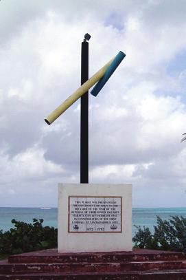
27 Goal #3: Conserve historic resources of the park Objectives Columbus Landfall Site San Salvadorians have every right to be proud of the determination that Columbus first steps in the New World were taken on San Salvador. His point of landing is thought be within the West Coast Marine Park near Bamboo Point. As such, a Memorial Plaque has been placed on the seabed at Longs Bay as a monument to commemorate Columbus anchoring place. Park staff will consult with Antiquities, Monuments and Museums Corporation (AMMC) and others to tell this story, interpret his point of anchoring and coming to shore. This would be part of the Interpretive Plan identified in Goal #5. Columbus Landing Site Memorial Plaque Photo: Sandy Voegeli Oral Histories Documenting oral histories is becoming more and more important as time passes. BNT will initiate an oral history project to document the life stories of older, more experienced residents of San Salvador. Goal #4: Promote positive relations with the San Salvador Living Jewels Foundation, Gerace Research Centre, and other community organizations and individuals. Objectives The San Salvador Living Jewels Foundation It would have been impossible to know whether a plan for a San Salvador National Park would be necessary without the SSLJ. For 10 years, this dedicated group has been working tirelessly to identify, support and establish these national parks. Together with the Foundation members, BNT will establish a special partnership that continues to engage the energy and dedication of this group. The character of this relationship was developed and mutually agreed upon through a Memorandum of Understanding (MOU) between the BNT and SSLJ, signed June, Gerace Research Center (GRC) Since 1971, the GRC has hosted thousands of international research scientists who have developed extensive data on the natural history of San Salvador. The results of this work significantly contributed to the identification of these special sites for park status. Additionally, GRC has and continues to host students of all ages, to teach them San Salvador National Parks Management Plan 27

28 about the natural history and biological significance of San Salvador. The character of the future relationship between BNT and the GRC will be carefully thought out and mutually agreed to as this plan is implemented. If all parties see value, it is also possible to consider a tripartite agreement between BNT, GRC, and LJF. General Community Outreach And Engagement The San Salvador National Parks are products of community participation over a sustained period of time. Appendix G shows the history of community involvement in this effort. It is critical that park staff continue this engagement through sessions to address park issues, community concerns, and to foster question and answer sessions, etc. Educational Programmes Based on approved interpretive themes, the park s Education Officer will liaise with local schools and other organizations to assure that young people are informed about the importance of preserving the park s natural resources, and the value that it brings to the community. Photo: BNT Nature Tourism Based Economic Opportunities BNT places a high priority on ensuring that the San Salvador National Park encourages and supports park related economic activities for the residents of San Salvador. This can significantly benefit the local economies, as well as strengthen and broaden local support for the parks. This may include, but not limited to kayaking, bird watching, guided tours via watercraft, fishing and diving. BNT will coordinate with the Ministry of Tourism (MOT) on Eco-Tourism Guide training workshops informing and building upon local skills for ecotourism activities along with providing assistance in getting the necessary permits. Efforts will also include helping residents to apply for grants or special loans to start eco-tourism businesses. Individual Practice Of Traditional Consumptive Resource Use Customs For some residents of San Salvador, traditional resource use is a critical part of their income and life style. Consistent with the purpose of the park, these individuals must be allowed and enabled to continue these customs, once the activities do not undermine the purpose of the park. This will involve continuing dialogue between these park users, BNT staff, and tourism providers. 28 San Salvador National Parks Management Plan
29 Goal #5: Provide visitors with opportunities to explore, learn, enjoy and appreciate the natural wonders, their complex ecology and its rich cultural heritage. Objectives Visitor information and interpretation In order to inform the public about the parks and to assist visitors in planning their trip before they arrive, BNT will develop and maintain an interactive page on the BNT website for San Salvador National Park. The webpage will provide up to date information on the park, including links to local registered guides. Primary Interpretive Themes BNT will take the lead in developing an Interpretive Plan based on the following themes: The national and international significance of the park s geomorphology and living ecosystems. Description of rare and endangered species that inhabit the park and why their preservation is important. The importance of the park as a nursery for fish and other marine organisms that are harvested outside park boundaries. The features that make San Salvador National Park unique within the Bahamas. The historical story and significance of Columbus s visit to San Salvador. On site visitor services and facilities Wherever the proposed park administrative office is located, a significant part of this complex will be allocated to providing visitor information and interpretive displays consistent with approved interpretive themes and planning. Even though the park does not have a mainland base, anticipated access points from land may include a BNT standard sign identifying the site, a 3 sided shelter kiosk with current information posted, a composting or pump-out toilets and, where possible, a cleared area for parking. Offsite education programmes It is vital that the park s Education Officer make every effort to develop educational programmes for both children and adult residents. Public presentations and school programmes should be a major part of the park s outreach efforts. Visitor Safety Visitor safety must always be a top priority. Park wardens will be trained and equipped to assist with boat problems, search and rescue efforts, CPR and first aid. All commercial tour guides must have a permit which includes the safety of their clients. San Salvador National Parks Management Plan 29

30 MANAGEMENT ZONING Management zoning involves decisions about what type of recreational or consumptive use should be allowed, and where. Typically it involves a range of spatial zones with varying levels and types of human activity. Zoning requires two steps: 1. A descriptive step which identifies important values and opportunities. It requires an inventory of resource characteristics and existing uses. 2. An allocation/prescriptive step in which decisions are made about which opportunities and values should be provided, and where. In short, the zoning process helps managers, operators, visitors and local communities understand what the park values are and where they are located, especially the sensitive resources. The proposed management zones for San Salvador National Park s five (5) units take into account important resources, use patterns, opportunities for visitor use, and management needs. The management zones identified here combines BNT policies and the protocol used in the Andros West Side National Park management plan. However only three (3) of the management zones allocated in West Andros plan are appropriate for San Salvador National Parks, including a Conservation Zone, Sensitive Resource Zone and Visitor Service/Park Administration Zone (zoning maps can be found in the following section). 30 San Salvador National Parks Management Plan
31 Conservation Zone In this zone, waters, and in some cases cays, will be managed to conserve natural resources and processes while accommodating uses and experiences that do not adversely affect the ecological integrity or scenic quality of the area. Regulations on levels and methods of traditional and commercial sports fishing will continue, and may be amended in the future as future conditions dictate. Scientific monitoring of the status of key features of the aquatic marine and freshwater environments (fish populations, coral cover, benthic community), bird species and population, and the populations of the endangered San Salvador Rock Iguana, will guide future use characteristics and levels. The vast majority of the San Salvador Parks will be designated as Conservation Zone. Sensitive Resource Zone This zone consists of places in the park that support resources that are (1) unusually fragile, (2) limited geographically and (3) would benefit from area-specific protection. Areas in this zone will be managed to restore where appropriate, perpetuate target species and their habitats, and to limit and remove potentially disruptive activities. The following areas will be designated in this zone: Pigeon Creek and Snow Bay National Park The entire Pigeon Creek aquatic marine environment Graham s Harbour Seabird and Iguana National Park Green, Catto, Gaulin and White Cays, including a 100 ft. buffer zone around each cay Selected dive sites West Coast Marine Park All dive sites, including a 100 ft. buffer zone around each site Green s Bay National Park None identified in this plan Southern Great Lakes National Park All of the cays within the park boundary, including a 100 ft. buffer around each cay Visitor Services/Park Administration Zone This zone will consist of buildings, grounds, docks and marina space leased or purchased for staging mainland park operations, educational programmes, access to parks, and other visitor services. It is important to note that the San Salvador National Park does not encompass any privately owned land. The areas being considered for the Administration Zone classification however, are located adjacent to or outside of park boundaries, which includes an administrative headquarters based in or near Cockburn Town and will be situated in a leased building or purchased land. BNT will work with the Administrator s Office, Local Government and private landowners to permit modest development at key access points to each national park. If possible, with land owner agreement, each of these areas may have a standard park identification sign, a three sided shelter/kiosk, sanitary facilities, a parking area for 3 to 5 cars, and a dock as appropriate to the site. San Salvador National Parks Management Plan 31

32 The following section profiling individual national parks offers more details on access points for each area. Recognizing the absence of any mainland base within park boundaries, future planning may consider slight boundary adjustments that would consider specific uses for vacant crown owned land that would enhance access or provide critical habitat of wildlife. NOTE: In terms of IUCN protected area classification, the conservation zone used by this plan is comparable to IUCN category #2, the sensitive resource zone is comparable to IUCN category #1a, and the visitor use/park administrative zone does not have a comparable IUCN category. Photo: Sandy Voegeli 32 San Salvador National Parks Management Plan

33 Photo: Sandy Voegeli NATIONAL PARK PROFILES AND STRATEGIES Graham s Harbour Iguana and Seabird National Park Location Graham s Harbour /Rice Bay trends from Barker s Point north to Green Cay, northeast along the fringing reef toward and around White Cay, heading southeast towards the Three Sisters Rocks. All cays within park boundaries are crowne land, and are included in the park. Graham s Harbour Physical Resources A dock is location at Graham s Harbour, and restroom facilities, parking, and recreational area are location at the adjacent community park, that is privately owned. Graham s Harbour Biological Resources Protected by fringing reefs, Graham s Harbour contains the most stable and extensive seagrass meadows around the island. It is buffered against extremes in water current velocity and is approximately 9 feet deep at mean low tide. As a unit of San Salvador National Park, Graham s Harbour protects the largest remaining iguana population (Green Cay), the largest and most diverse seabird colonies (Catto, Gaulin, Green and White Cays) in San Salvador, and protects the extensive eelgrass beds and coral reefs that serve as important marine nurseries. Species of significance found at Graham s Harbour, include the critically endangered San Salvador rock iguana (Cyclura rileyi rileyi), nesting seabirds and waterbirds such as the Brown Booby (Sula leucogaster), Red-fotted Booby (Sula sula), Bridled Tern (Sterna anaethetus), Roseate Tern (Sterna dougallii), Royal Tern (Thalasseus maximus), Sooty Tern (Onychoprion fuscatus), Least Tern (Sternula antillarum), Magnificent Frigatebirds (Fregata San Salvador National Parks Management Plan 33
34 GRAHAM S HARBOUR IGUANA AND SEABIRD NATIONAL PARK Management Zones White Cay Graham s Harbour Iguana and Seabird National Park Catto Cay Green Cay Gaulin Cay Cut Cay Man Cay Three Sisters Queen s Highway Gerace Research Center 0 2 Miles Management Zones Administrative Zone Km Sensitive Zone With 100 Feet Marine Buffer Conservation Zone Park Boundary Fringe Reef SAN SALVADOR NATIONAL PARKS Bahamas National Trust 34 San Salvador National Parks Management Plan
35 magnificensis), Brown Noddy (Anous stolidus), Audubon s Shearwaters (Puffinus lherminieri), White-tailed Tropicbird (Phaethon lepturus), Gull-billed Terns (Sterna nilotica), Double-crested Cormorant (Phalacrocorax auritus), and Laughing Gulls (Larus atricilla). Graham s Harbour Existing Uses Scientific research, some snorkeling and diving, commercial and subsistence fishing (including boats from other islands), Jet ski tours around San Salvador island pass through this park unit. Management Strategies In order to protect native seabirds, establish a 100 ft. buffer zone around all cays except Green Cay. This Sensitive Resource Zone will only be assessable to visitors with special permits, e.g. research. There will be power boat speed limits applied within 100 ft. of the primary reef areas. Provide information signage at the existing community park and two other ramps west of this developed area that offer boat access. In cooperation with local owners, upgrade dock, sanitary, parking and a shelter that already exist at this site. Provide 5 mooring buoys at Green Cay. Visitor use will be limited to marked foot trails except for those with special permits, to provide increased protection to sensitive areas of the cay for nesting seabirds and iguanas. Establish no anchorage zones, especially for large yachts, to protect critical marine habitats (reef and seagrass areas). Set speed limits/no wake zones to avoid disturbances to sensitive resources. Continue to engage private landowners where property borders park boundaries (i.e. Community park) Prohibit visitation to offshore cays during bird nesting season. Graham s Harbour Threats Recreation Wildlife Trafficking Watercraft Disturbances from Tour Operators Lack of infrastructure/signage Anchor damage Incompatible Coastal Development Boat Maintenance/Hull Cleaning Invasive Alien Species (marine and terrestrial) Iguana Feeding Disturbance of Wildlife Lack of communication Bioprospecting Overfishing & Illegal Fishing Practices Climate Change & Natural Distasters (sea level rise, elevated sea surface temperatures, hurricanes) Graham s Harbour Purpose The park protects the largest remaining population of the San Salvador rock iguana, the largest and most diverse seabird colonies found in The Bahamas, and extensive seagrass beds and reef system important for fisheries. San Salvador National Parks Management Plan 35
36 West Coast Marine Park Location Boundary along the west side extends out from the high water mark adjacent to the international airport runway and out to the drop off, or wall, with an additional buffer zone of 100 feet beyond the wall or buoy. Boundary continues south along the wall and around the southern point of Snow Bay, including marine waters surrounding Low Cay (private). The park boundary ends at the southern point of Snow Bay. Physical Resources Several mooring buoys are location throughout the park, that are utilized and maintained by local dive tour operators. West Coast Biological Resources San Salvador offers a wealth of attractions to the visiting diver. The island has shallow reefs and breathtaking wall dives which were first discovered by scuba divers in the 1970 s. West Coast Marine park is unique for its stunning water clarity, with a typical visibility of ft, and more than 20 miles of dramatic vertical walls, beginning at a depth as low as 40 feet. The rocky southern shoreline at French Bay provides vital nesting habitat for White-tailed Tropic birds and Audubon s Shearwaters. The critically endangered hawksbill turtle is the predominant sea turtle observed at West Coast Marine Park, with nesting activity on the southwest point of Sandy Point. Recent observations confirm the deep channels in the park, is a migratory route for species of whales, especially the humpback whale (A. Minkus, 2014). Historical Resources West Coast Marine Park is the anchorage location for Christopher Columbus first landfall to The Bahamas, and as such, a commemorative plaque sits on the seafloor in the park to recognize this historal site. Considering this significance, West Coast Marine Park is eligible for a UNESCO World Heritage Site designation, which would be the first in The Bahamas. Existing Uses Primarily diving and snorkeling and some fishing. Existing boat access if limited. Most access is via the established resort dive operators. Jet ski tours around the island pass through this park. Management Strategies Establish park administrative headquarters in or near Cockburn Town. Provide parking and information signage adjacent to the site recommended for park headquarters. Explore to improve public access at this site. Identify primary dive sites (30) and close adjacent waters to commercial and subsistence fishing in order to preserve resources and reduce conflict between divers and fishermen. Working with private landowners, explore additional opportunities for public access to this park. Provide 5 mooring buoys in the area north of Cockburn Town, and install moorings to accommodate larger vessels/yachts at Longs Bay. 36 San Salvador National Parks Management Plan
37 WEST COAST MARINE PARK Management Zones Bonefish Bay Club Med Cockburn Town Little Lake Fernandez Bay Columbus Landing Monument Long Bay Southern Great Lake National Park West Coast Marine Park Stouts Lake Queen s Highway Pigeon Creek Snow Bay Pigeon Creek and Snow Bay National Park Sandy Point French Bay Low Cay High Cay * ** Middle Cay Management Zones 0 2 Miles Administrative Zone Km Conservation Zone Park Boundary * Fringe Reef Cay privately owned and not included in park management zone SAN SALVADOR NATIONAL PARKS Bahamas National Trust San Salvador National Parks Management Plan 37
38 Prohibit harvesting of all parrotfish species, to ensure reefs are able to recover from elevated water temperatures. Establish no anchorage zones, especially for large yachts, to protect critical marine habitats (reef and seagrass areas). West Coast Threats Overfishing & Illegal Fishing Practices Lack of infrastructure/signage Anchor damage Incompatible Coastal Development Poaching Invasive Alien Species (marine) Lack of communication Groundings User conflicts between dive operators and fishermen Climate Change and Natural Disasters (sea level rise, elevated sea surface temperatures, hurricanes) West Coast Purpose The park protects some of the most dramatic and breathtaking coral wall formations in The Bahamas, that attract repeat divers annually, and rocky southern shorelines provides nesting habitat for seabirds. 38 San Salvador National Parks Management Plan

39 Photo: BNT Pigeon Creek and Snow Bay National Park Location The park includes the natural open water through the entire length of Pigeon Creek and the mangroves to the high water mark. This includes the waters surrounding the offshore Low, Middle, and High Cays, which are privately owned and not included in the park. Snow Bay extends from the high water mark to the wall, beginning at the northern point of the Bay and ending at the southern point of Snow Bay. It includes Nancy Cay and the marine areas surrounding Middle and High Cays (privately owned). Pigeon Creek and Snow Bay Biological Resources Pigeon Creek is the island s only tidal creek, making it an invaluable resource and a primary conservation area. National Park status for the creek and the waters surrounding the cays just offshore protects the island s most important nursery area. The creek includes mangroves, seagrasses, hard bottom corals and sponges. It is home to the island s main population of sea urchins. It is the only nursery area for the Nassau Grouper and is a nursery area for spiny lobster and numerous other reef fish. The island s fisheries rely primarily on this nursery area. Snow Bay is the sea connection to Pigeon Creek. The bay supports a high diversity of coral reefs and queen conch populations. Reef species eventually spawn and seed the areas downstream. This area also has a high value as an important fisheries location for local residents. Existing Uses Catch and release bonefishing, and subsistence fishing. Limited kayaking, canoeing, and sightseeing by tour guides using jet skis. Picnicking tours for hotel guests. Existing access is available at Pigeon Creek Settlement and Snow Bay. San Salvador National Parks Management Plan 39

40 Management Strategies In order to protect sensitive species, Pigeon Creek will be closed to all fishing activities, with the exception of Catch and Release bonefishing. A combination of power boat engine size and speed limits will be imposed as appropriate. Working with landowners, maintain the existing car parking area and dock at Pigeon Creek Settlement. Piegeon Creek and Snow Bay Threats Invasive Alien Species (marine and terrestrial) Lack of infrastructure/signage User conflicts Recreation Anchor damage Wildlife disturbance Incompatible Coastal Development Overfishing and Illegal fishing practices Iguana Feeding Climate Change & Natural Distasters (sea level rise, elevated sea surface temperatures, hurricanes) Pigeon Creek and Snow Bay s Purpose The park protects the island s only tidal creek, and the connectivity between the mangrove forests, seagrass beds and offshore reef system. 40 San Salvador National Parks Management Plan
Terrestrial Protected Area Nomination: Central Mangrove Wetland South-West, Grand Cayman
 Terrestrial Protected Area Nomination: Central Mangrove Wetland South-West, Grand Cayman The attached nomination, proposing that a parcel of land in the Central Mangrove Wetland be made a Protected Area
Title/Name of the area: Chwaka Bay, Zanzibar
 Title/Name of the area: Chwaka Bay, Zanzibar Presented by: Dr. Charles Lugomela, Ag. Head, Department of Aquatic Sciences and Fisheries, University of Dar es Salaam, P.O. Box 35064 Dar es Salaam, Tanzania
We, Ministers, assembled in Berlin for the International Conference on Biodiversity and Tourism from 6 to 8 March 1997
 March 8th, 1997 Berlin Declaration BIOLOGICAL DIVERSITY AND SUSTAINABLE TOURISM We, Ministers, assembled in Berlin for the International Conference on Biodiversity and Tourism from 6 to 8 March 1997 -
The MPA Name. The past and future of the. Montego Bay Marine Park Trust
 The MPA Name The past and future of the Montego Bay Marine Park Trust Park Boundaries and Sanctuary Area 100m/330ft/50 Fathom Depth Contour to The Average Highest High Tide Mark 50 Fathom/100M Depth Great
VARGAS ISLAND PROVINCIAL PARK
 VARGAS ISLAND PROVINCIAL PARK PURPOSE STATEMENT AND ZONING PLAN February 2003 VARGAS ISLAND PROVINCIAL PARK Purpose Statement and Zoning Plan Primary Role The primary role of Vargas Island Park is to protect
Adapting to climate change by promoting sustainable livelihoods, human and food security, and resilient ecosystems
 Adapting to climate change by promoting sustainable livelihoods, human and food security, and resilient ecosystems ICRI Indian Ocean Day December 13, 2011 Regional Challenges Atlantic Caribbean Challenge
Buck Island Reef National Monument News Release Date: Immediate Contact: Joel Tutein, Superintendent, x 222
 National Park Service U.S. Department of the Interior www.nps.gov 2100 Church Street, # 100 Christiansted, VI 00820 News Release Date: Immediate Contact: Joel Tutein, Superintendent, Joel.Tutein@nps.gov
PROUDLY BRINGING YOU CANADA AT ITS BEST. Management Planning Program NEWSLETTER #1 OCTOBER, 2000
 PROUDLY BRINGING YOU CANADA AT ITS BEST VUNTUT NATIONAL PARK Management Planning Program NEWSLETTER #1 OCTOBER, 2000 INTRODUCTION This newsletter launches the development of the first management plan for
TURTLE SURVIVAL ALLIANCE EXECUTIVE DIRECTOR
 Transforming passion for turtles into effective conservation action through a global network of living collections and recovery programs. TURTLE SURVIVAL ALLIANCE BACKGROUND TURTLE SURVIVAL ALLIANCE EXECUTIVE
TOWARDS SUSTAINABLE MANAGEMENT OF MARINE AND COASTAL HABITATS ASIA- PACIFIC DAY FOR THE OCEAN
 TOWARDS SUSTAINABLE MANAGEMENT OF MARINE AND COASTAL HABITATS WANNAKIAT THUBTHIMSANG PHUKET MARINE BIOLOGICAL CENTER, DMCR, THAILAND ASIA- PACIFIC DAY FOR THE OCEAN 20 NOVEMBER 2018, CONFERENCE ROOM 4,
How South Africa is making progress towards the Aichi 2020 Target 11
 How South Africa is making progress towards the Aichi 2020 Target 11 Montreal, Canada 2 May 2016 Oceans and Coasts Content Protected area considerations and progress 1994-2010 Terrestrial Protected Area
Bon Portage Island Conservation Campaign
 Bon Portage Island Conservation Campaign Protecting a Coastal Treasure Final Report to Nova Scotia Habitat Conservation Fund September 2012 Protection of Bon Portage Island Over the course of this two-year
Member s report on activities related to ICRI
 Member s Report INTERNATIONAL CORAL REEF INITIATIVE (ICRI) 32 nd General Meeting 7-9 December 2017 Nairobi, Kenya Member s report on activities related to ICRI MALAYSIA Reporting period November November
The Ecology and Economy of Coral Reefs: Considerations in Marketing Sustainability
 The Ecology and Economy of Coral Reefs: Considerations in Marketing Sustainability Rick MacPherson Director, Conservation Programs Coral Reef Alliance Coral Reefs in Peril: Worldwide Status 2004: 70% of
Overview CARIBBEAN MARINE BIODIVERSITY PROGRAM
 CARIBBEAN MARINE BIODIVERSITY PROGRAM Overview The Caribbean Marine Biodiversity Program is a five-year project (2014-2019), funded by the U.S. Agency for International Development and The Nature Conservancy,
Michipicoten Island Regional Plan
 Michipicoten Island Regional Plan This is one of twenty Regional Plans that support implementation of the Lake Superior Biodiversity Conservation Strategy (Strategy). The Strategy, prepared and overseen
A Proposed Framework for the Development of Joint Cooperation On Nature Conservation and Sustainable Tourism At World Heritage Natural sites.
 Introduction: A Proposed Framework for the Development of Joint Cooperation On Nature Conservation and Sustainable Tourism At World Heritage Natural sites Between The tourism industry and the UNESCO, World
REGIONAL AGREEMENT AND FRAMEWORK FOR MARINE MAMMALS CONSERVATION IN THE WCR: THE SPAW PROTOCOL AND THE MARINE MAMMAL ACTION PLAN
 REGIONAL AGREEMENT AND FRAMEWORK FOR MARINE MAMMALS CONSERVATION IN THE WCR: THE SPAW PROTOCOL AND THE MARINE MAMMAL ACTION PLAN ALESSANDRA VANZELLA-KHOURI SPAW Programme Officer United Nations Environment
Developing Lampi Marine National Park as an Ecotourism Role Model
 Developing Lampi Marine National Park as an Ecotourism Role Model Ms Tania Miorin, Country Director, Istituto Oikos & Dr Paul Rogers, Ecotourism Consultant PART I: BACKGROUND Ms Tania miorin OIKOS in Myanmar
The Regional Coral Reef Task Force and Action plan. 27 th ICRI. Cairns Australia July 2012
 The Regional Coral Reef Task Force and Action plan 27 th ICRI Cairns Australia July 2012 Western Indian Ocean Region East Africa mainland states Indian Ocean Islands states Biogeographic division of the
Twelve Apostles Marine National Park Australia
 EVALUATION REPORT Twelve Apostles Marine National Park Australia Location: Victoria, Australia coastal waters Global Ocean Refuge Status: Nominated (2017), Evaluated (2017) MPAtlas.org ID: 7703885 Manager(s):
Our Mission: Our Goals:
 Our Mission: Reef Relief is a nonprofit membership organization dedicated to improving and protecting our coral reef ecosystem. Our programs instill an attitude of stewardship in boaters, divers, fishermen
Tourism and Wetlands
 CONVENTION ON WETLANDS (Ramsar, Iran, 1971) 43 rd Meeting of the Standing Committee Gland, Switzerland, 31 October 4 November 2011 DOC. SC43-27 Tourism and Wetlands Action requested. The Standing Committee
Code of conduct on international travel and invasive alien species
 Code of conduct on international travel and invasive alien species Riccardo Scalera Programme officer, IUCN/SSC Invasive Species Specialist Group 37th meeting of the Standing Committee of the Bern Convention
33. Coiba National Park and its Special Zone of Marine Protection (Panama) N 1138 rev)
 N 1138 rev)") World Heritage status of the area and the Outstanding Universal Value of the Monarch butterfly migration phenomenon, c) Explore options for the development of non-butterfly related tourism activities;
World Heritage status of the area and the Outstanding Universal Value of the Monarch butterfly migration phenomenon, c) Explore options for the development of non-butterfly related tourism activities;
U.S. Activities in Puerto Rico, U.S. Virgin Islands and the Wider Caribbean. NOAA and the US Coral Reef Task Force
 U.S. Activities in Puerto Rico, U.S. Virgin Islands and the Wider Caribbean NOAA and the US Coral Reef Task Force U.S. Coral Reef Task Force Co-Chairs: National Oceanic and Atmospheric Administration (NOAA)
BABIA GÓRA DECLARATION ON SUSTAINABLE TOURISM DEVELOPMENT IN MOUNTAIN AREAS
 BABIA GÓRA DECLARATION ON SUSTAINABLE TOURISM DEVELOPMENT IN MOUNTAIN AREAS The participants of the International Workshop for CEE Countries Tourism in Mountain Areas and the Convention on Biological Diversity",
Land Management Summary
 photo credit: ANGAIR Anglesea Heath Land Management Summary The Anglesea Heath (6,501 ha) was incorporated into the Great Otway National Park in January 2018. This provides an opportunity to consider the
National Park Service Wilderness Action Plan
 National Park Service U.S. Department of the Interior National Park Service Wilderness Action Plan National Wilderness Steering Committee National Park Service "The mountains can be reached in all seasons.
Protected Areas & Ecotourism
 Protected Areas & Ecotourism IUCN Best Practice Guidelines, tools & protected area/ecotourism highlights from around the world Kathy Zischka, Director Annual General Meeting Australian 2 November Committee
photos Department of Environment and Conservation Biodiversity Conservation
 photos Department of Environment and Conservation Biodiversity Conservation EcoEducation - making the connections to biodiversity conservation Do you consider experiential learning of biodiversity in the
THE STORY OF MALDIVES. DR MARIYAM SHAKEELA Minister Of Environment and Energy Republic Of Maldives
 THE STORY OF MALDIVES DR MARIYAM SHAKEELA Minister Of Environment and Energy Republic Of Maldives Significance of ecotourism & coral reefs on regional economy Coral reefs are among the most diverse and
A GUIDE TO MANITOBA PROTECTED AREAS & LANDS PROTECTION
 A GUIDE TO MANITOBA PROTECTED AREAS & LANDS PROTECTION Manitoba Wildands December 2008 Discussions about the establishment of protected lands need to be clear about the definition of protection. We will
LATIN AMERICA / CARIBBEAN COIBA NATIONAL PARK PANAMA
 LATIN AMERICA / CARIBBEAN COIBA NATIONAL PARK PANAMA WORLD HERITAGE NOMINATION IUCN TECHNICAL EVALUATION COIBA NATIONAL PARK (PANAMA) ID Nº 1138 Bis Background note: Coiba National Park was nominated for
Creation of a Community-managed Biodiversity Park in the Saloum Delta of Senegal. Voré Gana Seck Director GREEN Senegal for People, Land, Ocean
 Creation of a Community-managed Biodiversity Park in the Saloum Delta of Senegal Voré Gana Seck Director GREEN Senegal for People, Land, Ocean Rationale for the Creation of the Biodiversity Park F In line
Appendix Template for Submission of Scientific Information to Describe Ecologically or Biologically Significant Marine Areas
 Appendi Template for Submission of Scientific Information to Describe Ecologically or Biologically Significant Marine Areas Title/Name of the area: Pedro Bank and Cays Presented by: Loureene Jones Smith
Unit 1 Lesson 1: Introduction to the Dry Tortugas and Sustainable Seas Expedition
 Unit 1 Lesson 1: Introduction to the Dry Tortugas and Sustainable Seas Expedition Lesson Objectives: Introduce students to the historical, geographic, and ecological importance of the Dry Tortugas. Introduce
The Vision for the San Juan Islands Scenic Byway
 The Vision for the San Juan Islands Scenic Byway 2 Judd Cove, Orcas Island, Courtesy of Kurt Thorson (kurtthorson.com) and San Juan County Land Bank Vision for the San Juan Islands Scenic Byway The San
MARINE PROTECTED AREAS LESSON PLAN Water Parks
 Marine Protected Areas U. S. Marine Protected Areas Lesson Plan MARINE PROTECTED AREAS LESSON PLAN Water Parks Theme U.S. Marine Protected Areas Links to Overview Essays and Resources Needed for Student
LAUNCH OF THE COASTAL ZONE MANAGEMENT TRUST
 A 60km stretch of coastline on the Yucatan Peninsula of Mexico is the testing ground for an idea that could protect fragile environments around the world: insuring coral reefs. The Economist World Ocean
Tubbataha Reefs Natural Park Philippines
 EVALUATION REPORT Tubbataha Reefs Natural Park Philippines Location: Cagayancillo, Palawan, Philippines; Sulu Sea, Pacific Ocean Global Ocean Refuge Status: Nominated (2017), Evaluated (2017) MPAtlas.org
Global Sustainable Tourism Destinations Criteria
 Global Sustainable Tourism Destinations Criteria Draft destination level Global Sustainable Tourism Criteria as proposed after Destinations and International Standards joint working group meeting and follow-up
Palau National Marine Sanctuary Building Palau s future and honoring its past
 A fact sheet from Sept 2015 Palau National Marine Sanctuary Building Palau s future and honoring its past Caring for the environment has long been an important part of Palau s culture. For centuries, traditional
Seychelles National Parks Authority Aspects of Research
 Seychelles National Parks Authority Aspects of Research First Pan-African Conference on Sustainable Tourism Management in African National Parks and Protected Areas: Challenges and Opportunities 15-18
IMPACTS OF THE RECENT TSUNAMI ON THE BUNDALA NATIONAL PARK THE FIRST RAMSAR WETLAND IN SRI LANKA
 IMPACTS OF THE RECENT TSUNAMI ON THE BUNDALA NATIONAL PARK THE FIRST RAMSAR WETLAND IN SRI LANKA by C.N.B. Bambaradeniya, IUCN The World Conservation Union, Sri Lanka Country Office (Email: cnb@iucnsl.org)
NATIONAL AIRSPACE POLICY OF NEW ZEALAND
 NATIONAL AIRSPACE POLICY OF NEW ZEALAND APRIL 2012 FOREWORD TO NATIONAL AIRSPACE POLICY STATEMENT When the government issued Connecting New Zealand, its policy direction for transport in August 2011, one
Map 1.1 Wenatchee Watershed Land Ownership
 Map 1.1 Wenatchee Watershed Land Ownership Map 1.1 Wenatchee Watershed Land Ownership The Wenatchee watershed lies in the heart of Washington state in Chelan County. Just larger than the state of Rhode
THE REALITY OF OCEAN ACIDIFICATION IN THE CARIBBEAN. Rachel Allen Centre for Marine Science, Jamaica
 THE REALITY OF OCEAN ACIDIFICATION IN THE CARIBBEAN Rachel Allen Centre for Marine Science, Jamaica AS A RESULT: Numerous scientific articles on OA Introduction of Acidification as a issue negotiated at
SCALING AND AMPLIFYING MPAS FOR THE EFFECTIVE CONSERVATION OF THE CENTER OF CENTER OF MARINE BIODIVERSITY,
 SCALING AND AMPLIFYING MPAS FOR THE EFFECTIVE CONSERVATION OF THE CENTER OF CENTER OF MARINE BIODIVERSITY, THE VERDE ISLAND PASSAGE A. Rex F. Montebon, Ph.D. 2015 EAS Congress Furama Resort, Danang, Vietnam
GLOBAL LEADERS IN BUILDING EFFECTIVE MARINE PROTECTED AREAS
 GLOBAL LEADERS IN BUILDING EFFECTIVE MARINE PROTECTED AREAS Marine protected areas (MPAs) like national parks on land set aside dedicated areas for conservation to help the ocean thrive, provide jobs,
GABON DESIGNED BY NATURE. First Pan-African Conference on Sustainable Tourism Management in National Parks and Protected Areas:
 Arusha, 16 th Octobre 2012 GABON DESIGNED BY NATURE First Pan-African Conference on Sustainable Tourism Management in National Parks and Protected Areas: Wildlife watching, Challenges and Opportunities
STATEMENT BY THE MOST HONOURABLE ANDREW HOLNESS, ON, MP PRIME MINISTER OF JAMAICA AT THE HIGH LEVEL PANEL FOR A SUSTAINABLE OCEAN ECONOMY
 STATEMENT BY THE MOST HONOURABLE ANDREW HOLNESS, ON, MP PRIME MINISTER OF JAMAICA AT THE HIGH LEVEL PANEL FOR A SUSTAINABLE OCEAN ECONOMY NEW YORK 24 SEPTEMBER 2018 Mr. Chairman, I am quite honoured to
Bazaruto Archipelago National Park-Mozambique. Mozambique. Workshop on MPAs- Is MPAs a useful tool In Fisheries management?
 Bazaruto Archipelago National Park-Mozambique Workshop on MPAs- Is MPAs a useful tool In Fisheries management? Norway ; 24-25 25 October 2006 By Paula Santana Afonso Institute for Fisheries Research Mozambique
MAP KEY. BLACK CIRCLES: Our 3 trip destinations of Tulum, Progreso, and Hacienda Temozon in Merida.
 SPRING 2017 GLOBAL OUTREACH is the newest product to come from The SA Way s educational brand. It is part study abroad, part ecoadventure, focusing on Spanish language, ethical service learning, environmental
June 29 th 2015 SOS LEMURS SPECIAL INITIATIVE
 June 29 th 2015 SOS LEMURS SPECIAL INITIATIVE 1 SUMMARY FOREWORD...3 SOS LEMURS HELP US SAVE MADAGASCAR S ICONS...3 EMERGENCY ACTION PLAN...4 WHY PROTECT LEMURS?... 4 THE IUCN ACTION PLAN!... 5 GENERAL
Status of Mangroves in Belize
 Status of Mangroves in Belize State of the Coastal zone Summit June 7 th 2012 Nadia Bood*, Emil Cherrington and Tim Smith Outline Introduction to mangroves Importance of mangrove to Belize National status
Pinellas County Environmental Lands
 Pinellas County Environmental Lands In addition to traditional parks and recreation facilities, Pinellas County owns and manages a system of environmental lands that provides specialized resource-based
Initiative internationale des récifs coralliens/ International Coral Reef Initiative
 Initiative internationale des récifs coralliens/ International Coral Reef Initiative International Coral Reef Initiative A unique informal partnership bringing together governments, international organizations,
SELF-ASSESSMENT CHECKLIST
 Tourism and Mountains A Practical Guide to Managing the Environmental and Social Impacts of Mountain Tours Using this Self-Assessment Checklist This checklist has been developed to help mountain-based
ReefFix. May, For the Organization of American States (OAS) and the Inter-American Biodiversity Information Network (IABIN)
 and the Inter-American Biodiversity Information Network (IABIN)") Fondation pour la Protection de la Biodiversité Marine FoProBiM B.P. 642 www.foprobim.org (mail) 6011 Henning St. Port-au-Prince, Haiti Bethesda, MD 20817 ReefFix Rapid Assessment of the Economic Value
Fondation pour la Protection de la Biodiversité Marine FoProBiM B.P. 642 www.foprobim.org (mail) 6011 Henning St. Port-au-Prince, Haiti Bethesda, MD 20817 ReefFix Rapid Assessment of the Economic Value
Virginian Atlantic (Ecoregion 8)
") Virginian Atlantic (Ecoregion 8) Background The Virginian Atlantic Ecoregion extends from the south side of Cape Cod to Cape Hatteras in North Carolina. The waters of the ecoregion are a mix of cold and
Virginian Atlantic (Ecoregion 8) Background The Virginian Atlantic Ecoregion extends from the south side of Cape Cod to Cape Hatteras in North Carolina. The waters of the ecoregion are a mix of cold and
An unparalleled opportunity. Creating marine reserves in the UK Overseas Territories
 An unparalleled opportunity Creating marine reserves in the UK Overseas Territories July 2012 An unparalleled opportunity Creating marine reserves in the UK Overseas Territories Who are the Pew Charitable
As outlined in the Tatshenshini-Alsek Park Management Agreement, park management will:
 Management Strategy General Strategy The priority management focus for the park is to ensure that its internationally significant natural, cultural heritage and recreational values are protected and that
Access: The rocky shoreline is only accessible via private property.
 10. Whale Cove Site description: Whale Cove is a small cove fringed by private homes and condominiums with diverse and relatively undisturbed rocky intertidal and subtidal habitat located approximately
BROUGHTON ARCHIPELAGO PROVINCIAL PARK
 BROUGHTON ARCHIPELAGO PROVINCIAL PARK PURPOSE STATEMENT AND ZONING PLAN March 2003 BROUGHTON ARCHIPELAGO PROVINCIAL PARK Purpose Statement and Zoning Plan Primary Role The primary role is to contribute
Safety Regulatory Oversight of Commercial Operations Conducted Offshore
 Page 1 of 15 Safety Regulatory Oversight of Commercial Operations Conducted Offshore 1. Purpose and Scope 2. Authority... 2 3. References... 2 4. Records... 2 5. Policy... 2 5.3 What are the regulatory
Project : Marine Ecology Research Center (MERC) Sabah, Malaysia
 Sabah, Malaysia") Project : Marine Ecology Research Center (MERC) Sabah, Malaysia Table of contents 1) Introduction of Malaysia 2) Malaysia Map & Location of MERC 3) Introduction of MERC 4) Activities of MERC 4.1) Active
Project : Marine Ecology Research Center (MERC) Sabah, Malaysia Table of contents 1) Introduction of Malaysia 2) Malaysia Map & Location of MERC 3) Introduction of MERC 4) Activities of MERC 4.1) Active
Protection of Ulcinj Saline
 Strasbourg, 25 March 2015 T-PVS/Files (2015) 21 [files21e_2015.docx] CONVENTION ON THE CONSERVATION OF EUROPEAN WILDLIFE AND NATURAL HABITATS Standing Committee 35 th meeting Strasbourg, 1-4 December 2015
Order of the Minister of Environment #39, August 22, 2011 Tbilisi
 Registration Code 360050000.22.023.016080 Order of the Minister of Environment #39, August 22, 2011 Tbilisi On preparatory stages and procedure of the methodology for Elaborating structure, content and
ICRI Monaco January 2010
 Economic Valuation of Coral Reefs in the Caribbean ICRI Monaco January 2010 Lauretta Burke World Resources Institute (WRI) Beautiful Valuable Valuable Valuable Valuable Valuable Photos: Krishna Desai Valuable
Malpelo Fauna and Flora Sanctuary Colombia
 EVALUATION REPORT Malpelo Fauna and Flora Sanctuary Colombia Location: South Pacific Global Ocean Refuge Status: Nominated (2017), Evaluated (2017) MPAtlas.org ID: 3803 Manager(s): Nancy Murillo Bohórquez
Quarterly Newsletter for WWF Caucasus and CEPF jointly supporting biodiversity conservation in the Caucasus
 Newsletter Hot in this issue: Black Sea Sturgeon October-December 2008 Quarterly Newsletter for WWF Caucasus and CEPF jointly supporting biodiversity conservation in the Caucasus Highlighted in issue:
 AGREEMENT Between Director of the Białowieża National Park, based in Białowieża (Poland) and Director of the National Park Bialowieża Forest, based in Kamieniuki (Belarus) and Head Forester of the Białowieża
SANTA-BOCA PROVINCIAL PARK
 SANTA-BOCA PROVINCIAL PARK PURPOSE STATEMENT AND ZONING PLAN March 2003 SANTA-BOCA PROVINCIAL PARK Purpose Statement and Zoning Plan Primary Role The primary role of Santa-Boca Park is to provide marine-based
Questions and Answers
 Home The Region Questions & Answers Documents Maps & Imagery Reserve Council Public Comment Search This Site About This Site Questions and Answers 1. Why is the President making this announcement? 2. What
Proposed Action. Payette National Forest Over-Snow Grooming in Valley, Adams and Idaho Counties. United States Department of Agriculture
 United States Department of Agriculture Forest Service January 2012 Proposed Action Payette National Forest Over-Snow Grooming in Valley, Adams and Idaho Counties Payette National Forest Valley, Adams
Sasagiu Rapids Provincial Park. Draft Management Plan
 Sasagiu Rapids Provincial Park Draft Management Plan 2 Sasagiu Rapids Provincial Park Table of Contents 1. Introduction... 3 2. Background and Park Attributes... 3 2.1 Park History.... 3 2.2 Natural Features...
ANNEX I. 40 th Anniversary of The Bahamas proposal for. The Expansion of. The. Protected Area System. The Commonwealth of The Bahamas
 ANNEX I 40 th Anniversary of The Bahamas proposal for The Expansion of The Protected Area System Of The Commonwealth of The Bahamas Table of Contents Introduction... 3 A Unique Opportunity for MPA Declaration...
Official Journal of the European Union L 337/43
 22.12.2005 Official Journal of the European Union L 337/43 PROTOCOL on the implementation of the Alpine Convention of 1991 in the field of tourism Tourism Protocol Preamble THE FEDERAL REPUBLIC OF GERMANY,
Forms of Natural Protection in Greece
 Forms of Natural Protection in Greece 105 th Primary School of Thessaloniki NATIONAL PARKS AND PROTECTED AREAS The irregular and constantly increasing human intervention in nature and the relentless exploitation
The Regional Coral Reef Task Force and Action plan. Indian Ocean Day. Reunion December 2011
 The Regional Coral Reef Task Force and Action plan Indian Ocean Day Reunion December 2011 Western Indian Ocean Region East Africa mainland states Indian Ocean Islands states Biogeographic division of the
RE: Access Fund Comments on Yosemite National Park Wilderness Stewardship Plan, Preliminary Ideas and Concepts
 September 30, 2016 Superintendent Yosemite National Park Attn: Wilderness Stewardship Plan P.O. Box 577 Yosemite, CA 95389 RE: Access Fund Comments on Yosemite National Park Wilderness Stewardship Plan,
ECOTOURISM. Hill & Mountain Ecosystems
 ECOTOURISM Hill & Mountain Ecosystems Importance of Hill & Mountain Areas Home to most indigenous populations Provider of essential resources Major source of water supply Centres of culture and indigenous
FINAL TESTIMONY 1 COMMITTEE ON RESOURCES UNITED STATES HOUSE OF REPRESENTATIVES. July 13, 2005 CONCERNING. Motorized Recreational Use of Federal Lands
 FINAL TESTIMONY 1 STATEMENT OF DALE BOSWORTH CHIEF Of the FOREST SERVICE UNITED STATES DEPARTMENT OF AGRICULTURE Before the SUBCOMMITTEE ON FORESTS AND FOREST HEALTH And the SUBCOMMITTEE ON NATIONAL PARKS,
COMMUNICATION AND AWARENESS-RAISING STRATEGY
 MEMORANDUM OF UNDERSTANDING ON THE CONSERVATION OF MIGRATORY SHARKS CMS/Sharks/Outcome 3.5 14 December 2018 3 rd Meeting of the Signatories (Sharks MOS3) Monaco, 10 14 December 2018 COMMUNICATION AND AWARENESS-RAISING
Nature Conservation and Developing Sustainable tourism in Myanmar
 Nature Conservation and Developing Sustainable tourism in Myanmar Myanmar Tourism O Tourism in Myanmar has boomed in recent years, with the industry generating nearly $1.8 billion in revenue in 2014 as
QUÉBEC DECLARATION ON ECOTOURISM World Ecotourism Summit Québec City, Canada, 2002
 QUÉBEC DECLARATION ON ECOTOURISM World Ecotourism Summit Québec City, Canada, 2002 The participants at the Summit acknowledge the World Summit on Sustainable Development (WSSD) in Johannesburg, August/September
National Wilderness Steering Committee
 National Wilderness Steering Committee Guidance White Paper Number 1 Issue: Cultural Resources and Wilderness Date: November 30, 2002 Introduction to the Issue Two of the purposes of the National Wilderness
Bridge District Board of Directors Meeting
 Partnership with the Golden Gate Bridge District National Park Service, and Golden Gate National Parks Conservancy presented at the Bridge District Board of Directors Meeting March 11, 2011 THE GOLDEN
Status of Antillean Manatees in Belize
 Status of Antillean Manatees in Belize Belize regional stronghold of the Antillean Manatee (Trichechus manatus manatus) Belize population is estimated to be in the region of 800 to 1000 animals Highest
4) Data sources and reporting ) References at the international level... 5
 Data sources and reporting ) References at the international level... 5") D- 1: Protected areas (PA) 1) General description... 2 1.1) Brief definition... 2 1.2) Units of measurement... 2 1.3) Context...2 2) Relevance for environmental policy... 2 2.1) Purpose... 2 2.2) Issue...
D- 1: Protected areas (PA) 1) General description... 2 1.1) Brief definition... 2 1.2) Units of measurement... 2 1.3) Context...2 2) Relevance for environmental policy... 2 2.1) Purpose... 2 2.2) Issue...
Coral reef management for sustainable development
 Coral reef management for sustainable development 2015 Australian Fellowship Program Building capacity to protect coral reefs as a foundation for sustainable development and ecosystem based adaptation
VERP Assignment for Ft. Fisher State Recreation Area
 Case Background VERP Assignment for Ft. Fisher State Recreation Area Fort Fisher State Recreation Area is a jewel of the southeastern coast of North Carolina. Comprised of a wide variety of maritime ecosystems,
ENVIRONMENT ACTION PLAN
 ENVIRONMENT ACTION PLAN 2015 16 Airservices Australia 2015 This work is copyright. Apart from any use as permitted under the Copyright Act 1968, no part may be reproduced by any process without prior written
NARRABEEN LAGOON SUMMIT am Wednesday, 13 April 2005 Warringah Council Chambers, 725 Pittwater Road, Dee Why.
 NARRABEEN LAGOON SUMMIT 9.15 9.30am Wednesday, 13 April 2005 Warringah Council Chambers, 725 Pittwater Road, Dee Why. NSW Minister for the Environment, the Hon. Bob Debus I am very pleased to be here to
BACKCOUNTRY TRAIL FLOOD REHABILITATION PROGRAM
 BACKCOUNTRY TRAIL FLOOD REHABILITATION PROGRAM Backcountry Trail Flood Rehabilitation A June 2013 Flood Recovery Program Summary In June 2013, parts of Southern Alberta were devastated from significant
What is Pimachiowin Aki? What is The Land that Gives Life?
 What is Pimachiowin Aki? What is The Land that Gives Life? Pimachiowin Aki is Canada s newest and first mixed (cultural and natural) World Heritage Site. In Anishaabemowin, the Ojibwe language, Pimachiowin
Vietnam Marine Protected Area Management Effectiveness Evaluation
 Vietnam Marine Protected Area Management Effectiveness Evaluation 5 th EAS Congress (16-21 November, 2015) Bui Thi Thu Hien IUCN Viet Nam Marine Protected Areas: Global Status There are over 161,000 protected
A vision for a healthier, more prosperous and secure future for all coastal communities. Can Gio Biosphere Reserve 2010 IUCN Vietnam MERD
 A vision for a healthier, more prosperous and secure future for all coastal communities Can Gio Biosphere Reserve 2010 IUCN Vietnam MERD Local woman caring for mangroves in Hau Loc, Thanh Hoa CARE International
Biosphere Reserves of India : Complete Study Notes
 Biosphere Reserves of India : Complete Study Notes Author : Oliveboard Date : April 7, 2017 Biosphere reserves of India form an important topic for the UPSC CSE preparation. This blog post covers all important