ANNEX I. 40 th Anniversary of The Bahamas proposal for. The Expansion of. The. Protected Area System. The Commonwealth of The Bahamas
|
|
|
- Sharleen Wood
- 5 years ago
- Views:
Transcription

1 ANNEX I 40 th Anniversary of The Bahamas proposal for The Expansion of The Protected Area System Of The Commonwealth of The Bahamas
2 Table of Contents Introduction... 3 A Unique Opportunity for MPA Declaration... 6 ABACO The Abaco Marls National Reserve East Abaco Creeks National Park Cross Harbour Conservation Area South Abaco Blue Holes Conservation Area ACKLINS/ CROOKED ISLAND Acklin's Bight ANDROS Andros Green Cay National Park Joulters Protected Area BIMINI North Bimini Marine Protected Area CAY SAL Cay Sal Land & Sea Park ELEUTHERA South Eleuthera Marine Protected Area GRAND BAHAMA North Shore -The Gap National Park East Grand Bahama National Park INAGUA Hogsty Reef Protected Area LONG ISLAND North Long Island Marine Reserve MAYAGUANA Booby Cay National Park NEW PROVIDENCE South West Marine Managed Area Perpall Tract National Park SAN SALVADOR San Salvador National Park SOUTHEASTERN BAHAMAS MARINE PROTECTED AREA PROPOSED PARK EXTENSIONS EXUMA Moriah Harbor Cay National Park Extension GRAND BAHAMA Lucayan National Park Expansion Peterson Cay National Park Expansion CONCLUSION..34 2
3 Introduction Over the past two decades, various commitments by governments have been made to conserve the marine and coastal environment, such as: the Biodiversity Convention (CBD); the Cartagena Convention and its protocols; and agreements under multilateral processes, such as CARICOM and the Organization of Eastern Caribbean States (OECS). Significant funding to protect the Caribbean s marine / coastal environment has been provided by the Global Environment Facility (GEF) and other public funding agencies. Governments, civil society, and the private sector have carried out many on-the-ground actions. While some progress has been made, trend lines point clearly toward the need for heightened action and leadership. In 2008, the Caribbean Challenge Initiative (CCI) was launched by a set of governments, as an effort to provide greater leadership, and to chart a new course for protecting and sustainably managing the marine and coastal environment across the Caribbean. The Bahamas was one of two governments that initially agreed to participate in the CCI in Since that time 7 other Caribbean governments have also committed to the CCI. 1. Objectives of CCI CCI is intended to galvanize leadership around the marine / coastal environment, and has had three broad, informal objectives to date: To catalyze high-level political will to protect and better manage marine and coastal resources To mobilize funding not only significant additional funding for marine / coastal conservation, but also to put in place sustainable funding mechanisms To accelerate and support on-the-ground action to implement the various marine and coastal conservation commitments made by governments. 2. Commitments under CCI To achieve these objectives, governments have made two types of commitments: 20 by 20 target - To effectively conserve at least 20% of their near-shore marine / coastal environment by (If this were achieved across the Caribbean, it would triple the area under protection, to 8.4 million ha.). Sustainable finance architecture target - To support and put in place new sustainable finance architecture that will generate long-term funding for the marine and coastal environment (taking the form of a set of trust funds and sustainable finance mechanisms, such as tourism fees). 3. Commitment under GEF Project The GEF Full Size Project Building a Sustainable Marine Protected Area requires a 10% commitment by February As of November 2013 the project has achieved only 758,684.4 hectares of the 2.5 Million required in for the project. This paper proposes 1,140,831.9 hectares which would bring the total hectares of protected area to 1,899,516.3 hectares or 4,693,807 acres. At present the project has only completed less than 1% of the project goal. 3
4 4. Progress to date Sustainable finance architecture Caribbean Biodiversity Fund This regional level trust fund was legally established in September Steps are now being taken to operationalize this regional fund, which will be based in The Bahamas. In Phase I, the CBF will be capitalized with a US $40 million endowment to support the fund s eight founding CCI countries. Bahamas Protected Area Fund (BPAF) CBF investment returns will be channeled annually according to an agreed formula to independent national level trust funds that are being set up in CCI countries. In The Bahamas, through a wide consultation process the BPAF legislation was drafted in Following further review by the Government the draft BPAF legislation was amended in early 2013 and sent to Cabinet. The Cabinet has given the approval for the draft legislation to be sent to Attorney General s Office. It is anticipated that the BPAF legislation will be officially passed in Parliament sometime in Marine Protected Areas (MPAs) Master Plans for protected area systems. In 2012 The Master Plan for The Bahamas Protected Area System was completed. This document is a comprehensive blueprint for action to achieve an effective national system of protected areas in The Bahamas, developed collaboratively by major stakeholders. For example, the Master Plan identifies new protected areas that need to be declared, and defines the additional funding, training, capacity building, and policy actions needed to effectively manage the protected area system. 4

5 Figure 1. Bahamas Wide Marine Gap Results 2008 The Bahamas Gap Analysis, which is a part of the Protected Areas Master Plan, recommended that establishment of protected areas in the following localities would contribute significantly, both in biodiversity coverage and in maintaining connectivity: Grand Bahama (eastern cays and offshore marine area extending towards Abaco) Abaco (eastern reef and nearshore environment (seagrass, mangroves) extending from Pelican Cays to Cherokee Sound) Northern Bimini (eastern half of sound, including near and offshore marine environment) South Andros (pine forest, coppice ridge and string of blue holes) Northwest Andros (tidal creeks, nursery areas for priority marine species) San Salvador (northern reefs and offshore cays) Long Island (northern coastline to offshore SPAGs) 5
6 Cay Sal Bank (coral reef, beaches for sea turtle nesting) Additional protected areas should be placed throughout the central and southern Bahamas to ensure greater representation and redundancy. New marine / coastal protected areas declared and improved management - since 2008, six new marine protected areas have been declared in The Bahamas. The original 2008 marine protected areas (MPAs) for The Bahamas comprised approximately 154,011 hectares (596 sq. miles). As of June 2012, The Bahamas now has 758,684 hectares (2929 sq. miles) of marine protected areas, which are legally defined. This accounts for 3-5% protection of The Bahamas near shore marine environment. A Unique Opportunity for MPA Declaration Two significant events are taking place in 2013, namely The Bahamas will be celebrating its 40 th Anniversary of Independence and the first Summit of Caribbean Political and Business Leaders will be held to officially launch the second phase of the Caribbean Challenge Initiative. To help fulfill The Bahamas 20 by 20 commitment under the Caribbean Challenge Initiative, the National Implementation Support Programme (NISP) Partnership has developed this proposal for the Ministry of Environment and Housing consideration for inclusion in the 40 th Anniversary activities undertaken by government. This proposal is designed to add an environmental component to the celebratory activities being held in honor of our country s 40 th anniversary of Independence. Currently the Bahamas Protected Area System consists of 27 national parks and four marine reserves. In total there are 31 areas in the Bahamas National Protected Areas System. The 40 for 40 Campaign seeks to have at least 9 new Marine Protected Areas (MPAs) declared in honor of the 40 th anniversary of our country s independence. In keeping with national celebrations, it is envisioned that these new protected areas will be established throughout the entire The Bahamas. The second phase of CCI was launched in May 2013, at a Summit of Caribbean Political and Business Leaders. The Summit was co-hosted by Prime Minister Keith Mitchell of Grenada, Premier Orlando Smith of the British Virgin Islands, and Sir Richard Branson (CEO, Virgin). The Summit brought together for the first time Heads of Government, CEOs of major corporations with Caribbean business operations, and key partners, to set a new course for the region s marine and coastal environment. The event created opportunities for Leaders to: (i) Endorse, at the highest level, new commitments to marine conservation by government and private sector leaders (covering such issues as marine protected areas, fisheries, tourism, and ecosystem-based adaptation); (ii) Announce new, concrete conservation actions being taken; (iii) Announce new funding programs; and (iv) Announce new innovative public-private partnerships. 6
7 The Bahamas participated in the Summit during which, the Government restated its commitments to the CCI and committed to further extend the national protected area system of The Bahamas by including in the existing network additional marine and coastal areas. Since March 2010, NISP partners comprised of the Bahamas National Trust, The Department of Marine Resources, The Nature Conservancy and the BEST Commission have been working on the project Building a Sustainable National Marine Protected Area Network for The Bahamas. Additionally, since January 2012, The Nature Conservancy in conjunction with partners has been implementing the project Expanding Marine Protection across The Bahamas with the support of the Waitt Foundation. Both projects seek to advance The Bahamas goals under the Caribbean Challenge Initiative particularly as it relates to the 20% by 2020 target and improving effective management of our national protected areas system by Bearing in mind the recommendations of the Gap Analysis, as well as taking into consideration stakeholder consultation, existing MPA proposals and the 40 for 40 campaign, project partners have identified the following sites for MPA declaration in 2013: 7
8 Proposed Areas Island Size (acres) 1. The Abaco Marls National Abaco 192,500 Reserve 2. East Abaco Creeks Park 95, Cross Harbour Conservation 14,000 Area 4. South Abaco Blue Holes Park 34, Bight of Acklins Protected Acklins 61,500 Area 6. Andros Green Cay National Andros 580 Park 7. The Joulters, North Andros 92, North Bimini Marine Bimini 6000 Protected Area 9. Cay Sal Land and Sea Park Cay Sal 1, South Eleuthera Marine Eleuthera 2,750 Reserve 11. North Shore The Gap Grand Bahama 280,000 National Park 12. East Grand Bahama National 12,500 Park 13. Hogsty Reef Protected Area Inagua 7, North Long Island Marine Long Island 42,000 Reserve 15. Bobby Cay National Park Mayaguana Southwest New Providence New Providence 18,000 Marine Managed Area 17. Perpall Track San Salvador National Park San Salvador 17, Southeastern Bahamas South Eastern Bahamas 1,920,000 Marine Park (Acklins, Crooked Island Samana Cays etc.) Park Expansion Areas Park Expansions Islands Size (acres) Moriah Harbour Cay National Park Expansion Exuma 18,000 Lucayan National Park Grand Bahama 2,880 Expansion Peterson Cay National Park 1000 Expansion 8

9 A map of the proposed MPA sites and park expansions listed above can be found in Figure 2 below. Figure 2. Map of proposed MPAs and national parks for expansion. 9

10 ABACO The Abaco Marls National Reserve Size: 192,500 Acres The Marls is an extensive mangrove flats located on the Western side of Abaco. Local bonefishing guides heavily use the Marls. The Marls serves as an important nursery habitat for commercially and ecologically important species. The purpose of the proposed park is to protect a portion of this vital wetland habitat, while still allowing cultural and recreational activities. The proposal suggests that fishing be allowed, and that existing fishing regulations be enforced within the boundaries. Protecting this creek system will ensure that nursery habitats for Queen conch, groupers and turtles, will be safeguarded against development.

11 East Abaco Creeks National Park Size: 13,000 Acres This is an extensive wetland habitat connected hydrologically through blue holes that include the Snake Cay creeks, the Bight of Old Robinson and Cherokee Sound. The purpose of the proposed park is to protect vital wetland habitat, while still allowing cultural and recreational activities. The proposal suggests that fishing be allowed, and that existing fishing regulations be enforced within the boundaries. Protecting this creek system will ensure that nursery habitats for Queen conch, groupers and turtles, will be safeguarded against development. The endangered white crowned pigeon and a few other offshore birds have been seen roosting and nesting in the mangroves in the area as well. Like Cross Harbour Bahamians have historically used these creaks for subsistence fishing and enjoyment. The Bight of Old Robinson has the second highest density of blue holes in The Bahamas. Research has shown that Bahamian blue holes have the highest biodiversity of any underwater caves in the world. The hydrologic connectivity of these blue holes highlights the importance of the protecting these systems from anthropogenic impacts due to development.
 as it falls under the new Forestry Legislation. Additionally, this site has a high marine biodiversity and abundant fish stocks.")
12 Cross Harbour Conservation Area Size: 14,000 acres Located on crown land from Blackwood Point to Cross Harbour Point, this proposed conservation area should be officially declared a Conservation Forest (no-build zone) as it falls under the new Forestry Legislation. Additionally, this site has a high marine biodiversity and abundant fish stocks. It is an important breeding ground for nurse sharks and the Queen conch and some believe it is perhaps the most important bonefish breeding ground on the entire Little Bahama Bank. Economically this area is significant as it yields B$ 141 million for the Bahamian economy. Culturally, Cross Harbour is one of the primary bonefishing areas on all of Abaco, used by local lodges and independent bonefish guides and residents of south and central Abaco use the pine forests, beaches and water for recreation. The ramp is an important facility for local fishermen.

13 South Abaco Blue Holes Conservation Area Size: 34,000 Acres The South Abaco Blue Holes Conservation Area is located on crown and treasury pinelands between the South Bahama Palms Shores residential area and the Crossing Rocks Settlement on South Abaco, which is on the eastern side of Ernest Dean Highway. The proposed conservation area protects four (4) inland blue holes/ sinkholes as well as thirteen (13) offshore blue holes. The inland sites have become world renowned for their amazing scientific value including new species of cave adapted animals, but even more fascinating, the location of pre-historical remains of animals never before known to exist in The Bahamas. Historically, the area has been used for recreation, cave diving and tours, and noncommercial fishing. The South Abaco Blue Holes show great potential for continuing ecotourism and environmental education opportunities, continuing its international fame following an extensive National Geographic article. The proposal takes into consideration the environment as well as stakeholder opinion; having been developed with considerable community involvement.
. The area is also important for both seabirds and White-Crowned Pigeon breeding.")
14 ACKLINS/ CROOKED ISLAND Acklin's Bight Size: 61,500 Acres The cays known as North Cay, Fish Cay, Guana Cay, Wood Cay and South Cay constitute the known range of the Bahamian Rock Iguana (Cyclura rileyi nuchalis). The area is also important for both seabirds and White-Crowned Pigeon breeding. The immediate surroundings and a portion of the Acklin s Bight mangrove flat, serve as important nursery habitats for the reefs located adjacent to the islands of Acklin s and Crooked Island. Salina Point is a major bone fishing attraction for the island and adding a protected area will increase ecotourism for the site. 14

15 ANDROS Andros Green Cay National Park Size: 580 Acres* Green Cay is an isolated island on the eastern side of the Tongue of the Ocean with no permanent dwellings; however, it provides an anchorage and a fishing ground. Coral reefs are found along the southern and eastern shoreline and around the rocks and ledges extending eastwards from the cay over the Great Bahama Bank. There are areas of mangrove and seagrass beds although the seagrass beds are relatively sparse. It is recommended that the boundaries of this park be expanded into open and nearby deep waters*. 15

16 Joulters Protected Area Size: 79,500 Acres The Joulters are located north of North Andros and are comprised of several islands. The area is an extensive mangrove flat system and is presently utilized for bonefishing. The critically endangered Piping Plovers reside on the island chain. Traditional activities and ecotourism activities will continue to be allowed as well as enforcement of current laws and regulations. 16
 as well as commercially important species.")
17 BIMINI North Bimini Marine Protected Area Size: 6,000 Acres The eastern half of Bimini Sound and adjacent waters contain mangrove and seagrass habitats. The mangrove system is an important nursery habitat for lemon sharks (researched by the Bimini Biological Field Station) as well as commercially important species. Because it is one of the few mangrove systems on the western edge of the Great Bahama Banks, it may be an important nursery area for many species on a regional scale. Catch-and-release bonefishing is important within the proposed reserve area. 17

18 CAY SAL CAY SAL LAND & SEA PARK Size: 1,750,000 Acres The Cay Sal Bank is located midway between Cuba, the Bahamas and the USA. The isolated cays that exist on the bank are home to many seabirds and provide resting stops for migratory birds. Given its remote location, the area remains relatively undisturbed. Cay Sal contains important turtle nesting habitats, healthy reef systems and diverse commercially important species. The Cay Sal Bank was earmarked in the 2008 Bahamas wide Marine Gap Results as being a critical area for protection. The Bank has been subject to a number of recent research projects, the Deepwater Horizon oil spill Bahamas Preassessment exercises in 2009, the Khaled bin Sultan Living Ocean s Foundation Global Reef Expedition in 2010 and ongoing bird assessments. The Cay Sal Land & Sea Park was first proposed in 1982 as part of the Bahamas National Trust s Development of a National park system. The Cay Sal Land & Sea Park would encompass the entirety of the Cay Sal Bank: the islands, the corals and a bit of deeper water surrounding the bank. 18
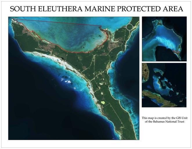
19 ELEUTHERA South Eleuthera Marine Protected Area Size: 2,750 Acres The area proposed initially included an area around Powell Point and the Schooner Cays off Cape Eleuthera. This area was ranked among the highest during the scientific review of proposed fishery reserve sites by Stoner et al. (1999), because of the areas importance for conch, lobster, grouper, and coral reef habitats. The proposed Fishery Reserve area and surrounding areas for South Eleuthera was extensively studied in the late 1980 s and early 1990 s as one of the focal sites for the Perry Institute for Marine Science/Caribbean Marine Research Center s Fisheries Oceanography and Recruitment in the Caribbean and subtropics (FORECAST) research program. As a result, there are numerous published accounts on habitats within the area, as well as the status of its conch and lobster stocks. These studies have shown the importance of the reef area near Cape Eleuthera as lobster habitat, and the area around the Schooner Cays as containing some of the highest conch densities in the Bahamas. Due to social concerns the initial areas proposed have been modified. Nevertheless, the proposed area contains important inshore areas for conch, juvenile lobsters, and juvenile reef fish, including snappers and groupers. While the area currently being considered does not contain the diversity of key habitats that the initially proposed area possessed, it does include some areas of ecological significance. Habitats within the currently proposed area include extensive sand, seagrass and low-relief hardbottom habitats. The proposed area also includes several mangrove lined tidal creek systems, conch habitat, and nurseries for lobster, Nassau grouper and several snapper species. 19
20 20
21 GRAND BAHAMA North Shore -The Gap National Park Size: 280,000 Acres Located on the north eastern shore of Grand Bahama, the proposed park covers an area 40miles from Dover Sound to Cormorant Bush (between Pelican Point and McClean s Town). The coastal area on the north shore consists of mangrove wetlands, tidal creeks, sand and mud flats, beach strand and rocky shores. An extensive area of blue holes and an as yet unexplored karst cave system also exists in the coastal area northeast of Dover Sound, while further inland where land rises slightly from the shore, pine woodlands with palm understory occurs. Numerous bird species rely on the area s coastal and inland habitat. The pine forests in the area were extensively logged in the 1950 s and the last reported logging activity occurred in A pulpwood loading terminal was constructed at North Riding Point in the late 1950 s and a logging camp community of 200 homes known as The Gap community existed for several years up until the end of the logging. Remnants from this historic era are found in the grid of logging roads that is still in existence and the terminal structure at North Riding Point. Approximately 50% of the land within this proposed park is owned by the Grand Bahama Development Company and The Grand Bahama Port Authority, while beyond the boundaries of Freeport are Government owned land. The only inhabited area in the proposed site is Water Cay, in which the surrounding waters are being proposed for protection. 21

 are planned for mid-summer, which will provide substantial biological data on the health of marine and terrestrial ecosystems, including areas")
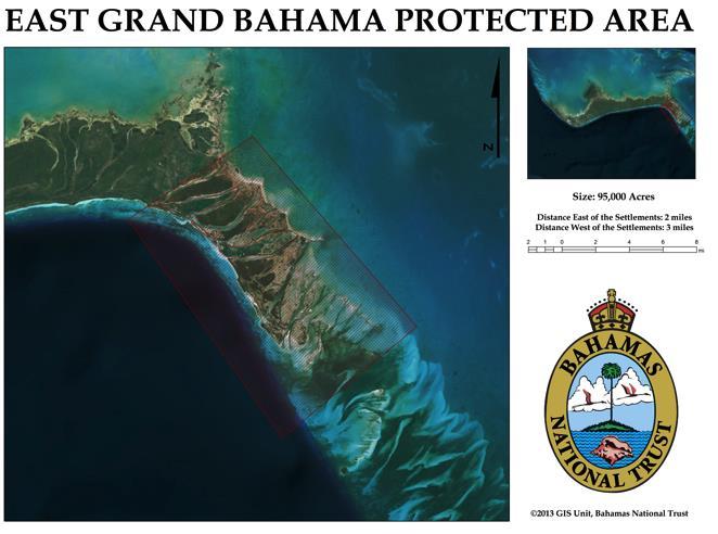
22 EAST GRAND BAHAMA NATIONAL PARK Size: 12,500 Acres Located in the area south of Sweetings Cay, a series of tidal creeks provide prime flats fishing habitats that support the local communities in east Grand Bahama. The extensive mangrove forests are corridors to the offshore reef system that are included in the proposed national park for East Grand Bahama. Explored blue hole systems on Sweetings Cay are connected to undisturbed underground karst systems that are supported as National Parks to benefit the local economy of Sweetings Cay. Rapid Ecological Assessments (REAs) are planned for mid-summer, which will provide substantial biological data on the health of marine and terrestrial ecosystems, including areas important for bonefish. 22
23 23

24 INAGUA (area) HOGSTY REEF PROTECTED AREA Size: 7,300 Acres The Hogsty Reef Protected area would encompass the Hogsty Reef atoll, located North-East of Inagua. This atoll is a popular site for diving and has diverse coral and fish populations. Hogsty Reef was visited in 2010 as part of the Khaled bin Sultan Living Oceans Foundation s Global Reef Expedition. This area was earmarked in the 2008 Bahamas Gap Assessment document as being of critical importance. The two islands are valuable nesting sites for seabirds and provide a resting site for migratory birds. This protected area would cover the entirety of the atoll: the lagoon, the reefs and the two islands. 24

25 LONG ISLAND North Long Island Marine Reserve Size: 42,000 Acres This site includes an excellent mixture of windward and leeward coral reefs, and onshore seagrass and mangroves around Calabash Bay and Glenton Sound. Tidal channels flowing into the bay and sounds may provide important juvenile habitat for a variety of fish species and lobster. A grouper spawning aggregation site near Cape Santa Maria also makes this a very high priority site for protection. A dive operation at Stella Maris uses the reef in this area and may be supportive of a reserve. 25

26 MAYAGUANA BOOBY CAY NATIONAL PARK Size: 120 Acres Booby Cay is located on the eastern side of the island of Mayaguana. Booby Cay is of significant value for the resting seabirds of the area. It is also the sole location of Bartsch s Rock Iguana, Cyclura carinata bartschi, found only in the Bahamas on this island. This park would protect the entirety of the island. Booby Cay is one of three areas in The Bahamas internationally recognized as Key Biodiversity Areas (KBAs). 26

27 NEW PROVIDENCE SOUTH WEST MARINE MANAGED AREA Size: 18,000 Acres This area is just off of western New Providence Island would protect an important heritage fishing area and lucrative dive sites. This protected marine area would provide an opportunity for both education and economic benefits through sustainable non-extractive use of resources. Films alone have brought in $375 million dollars over the last five years, which is a direct economic benefit to the southwestern side of New Providence Island. In addition, a study conducted by The Bahamas Diving Association in 2008 estimated that the shark diving industry in The Bahamas alone generates roughly $78 million a year. As such, zoning within the described boundaries will vary to provide higher levels of protection for key reef and seagrass sites. 27

28 Perpall Tract National Park Size: 177 Acres Perpall Tract is one such area, containing its rich variety of native, endemic and medicinal flora. The majority of this area is relatively undisturbed by human activity and is an ideal opportunity to preserve Bahamian native trees and shrubs for the benefit of current and future generations. In addition to this flora, there is a network of historic wells, each supporting its own unique mini-ecosystem of lilies, ferns and other wildlife. The area therefore offers examples of important natural biodiversity and history. The well fields within Perpall Tract provide essential flood drainage for nearby residential neighbourhoods. 28

29 SAN SALVADOR San Salvador National Park Size: 17,000 Acres San Salvador is home to a critically endangered iguana, and the most impressive assemblage of nesting seabirds to be found anywhere in the Bahamas. For many years the economy of the island has benefited from recreational scuba divers who visit repeatedly to explore the magnificent marine environment of the island. The proposed San Salvador National Park system comprises of a total of five (5) areas, two (2) of which are internationally recognized as Key Biodiversity Areas (KBAs), important for sustaining populations for the endangered San Salvador rock iguana and seabird species, and the island s only tidal creek. The only tidal creek on the island of San Salvador is critical to the Park proposals for The San Salvador National Park System were first proposed in 2006, and presently ready for resubmission, highly supported by the people of San Salvador. The areas proposed are: 1) Graham s Harbour (north), 2) Southern Great Lake (inland lake), 3) Dive sites (south west), 4) Pigeon Creek and 5) Snow Bay. 29
.")
30 Southeastern Bahamas Marine Protected Areas Size: Approximately 1,920,000 Acres The Southestern Bahamas Marine Protected Area is a recommendation of the 2013 REA for the Southeastern Bahamas (Samana Cay, Plana Cays, Mayaguana, Acklins and Crooked Island). The REA recommended that a terrestrial and marine protected area be established around the Plana Cays, which would also include suspected spawning aggregation sites. The protected area would contain areas of all types of benthic habitats (tidal creeks, wetlands, sea grasses, sandy bottoms, muddy bottoms, patch reef areas, spur and groove reef areas, hard bottoms, shallow fore reefs, wall areas, deep oceanic areas, sea mounts) in order to provide appropriate niche spaces and nursery areas for all life stages of all resources in the protected area. The MPA would also provide possible enhanced connectivity for larval transport and genetic material transmission between the Caribbean and southern Bahamas to the northern Bahamas. In addition, a more secure corridor for the safe transit of highly migratory species such as turtles, whales, sharks, and other pelagic species would be made available for movement from the eastern Caribbean up through The Bahamas. The protected area would also have positive impacts locally and Bahamas-wide if established because of the linkage to the MPA system to the south, -Inagua, as well as to the north, - the Exuma Cays Land and Sea Park. This area would include the island of East Plana Cay as well, home of the only endemic land mammal to the Bahamas (the Bahamian Hutia). 30
.")
31 Proposed Park Expansions EXUMA Moriah Harbor Cay National Park Expansion Size: 14,000 Acres Moriah Harbour Cay National Park was established in The approved area currently protects less than half of the mangrove flats and areas of key biodiversity importance (e.g. Pigeon Cay). This new proposal seeks to expand the boundaries to protect more of the mangrove flats and other biodiverse habitats. 31

32 Lucayan National Park Expansion Size: 2,750 Acres Established in 1992, the 40-acre, Lucayan National Park (LNP) protects the longest known karst cave system that connects the pine forest in the north to the creeks in the south, and a minimal portion of Gold Rock creek. Much of the cave system lies outside the current park boundary, includes a minimal portion of Gold Rock Creek, and presently ends at the beach. The proposal seeks to expand park boundaries to include the extent of the Gold Rock creek system to the east, known mapped karst caverns to the north, and the coral reef system to the south. Results from a Rapid Ecological Assessment (REA) conducted in April 2013, indicates that the adjacent coral reef system are quite healthy. 32
 for a myriad of ground nesting seabirds because it is predator-free.")
33 Peterson Cay National Park Expansion Size: 1,000 Acres Peterson Cay, originally granted in 1971, is located 7 miles east of Lucaya off of the southern shore of Grand Bahama. It is the only cay on the leeward shore of Grand Bahama and an important bird area (IBA) for a myriad of ground nesting seabirds because it is predator-free. The current park area encompasses the Cay to the quarter mile surrounding marine area. To have a more sizable impact on conservation as well as prolonged and sustainable resource benefits, we request that the Park s boundaries be extended from the Lucayan waterway to Sharp Rocks Point, which would include the coast of the mainland and extend an additional mile south of the cay to protect the coral reefs in that vicinity. 33
34 Conclusion As the NISP and other community and NGO stakeholders continue to work towards the identification of areas for consideration by government for protection and management, this proposal seeks to put forward areas for consideration as part of landmark efforts of the 40 th anniversary of the country s independence. Should the Ministry and the government seek to move forward with the declaration of some or all of these areas this will increase The Bahamas level of protection from the present 3-5% thus significantly advancing recent efforts to reach the 20% target by Such a bold declaration of new marine and protected areas will also reinforce The Bahamas position as a regional leader in the Caribbean Challenge Initiative and definitively declare the environment as an important part of The Bahamas milestone towards sustainable development. 34
Ocho Rios, Jamaica GEF-IWCAM AND IABIN INDICATORS MECHANISM WORKSHOP March TNC s Marine Protected Area Work.
 TNC s Marine Protected Area Work in the Caribbean GEF-IWCAM AND IABIN INDICATORS MECHANISM WORKSHOP 10-12 March 2008 Ocho Rios, Jamaica Caribbean Decision-Support System 3 years (2003-2006) $2.2 million
Caribbean Challenge Initiative
 Caribbean Challenge Initiative Outline of Presentation 1. Context and history 2. Phase I of CCI 3. Phase II of CCI Origins of CCI Governments increasingly aware of economic values of marine / coastal resources,
How South Africa is making progress towards the Aichi 2020 Target 11
 How South Africa is making progress towards the Aichi 2020 Target 11 Montreal, Canada 2 May 2016 Oceans and Coasts Content Protected area considerations and progress 1994-2010 Terrestrial Protected Area
Palau National Marine Sanctuary Building Palau s future and honoring its past
 A fact sheet from Sept 2015 Palau National Marine Sanctuary Building Palau s future and honoring its past Caring for the environment has long been an important part of Palau s culture. For centuries, traditional
Overview CARIBBEAN MARINE BIODIVERSITY PROGRAM
 CARIBBEAN MARINE BIODIVERSITY PROGRAM Overview The Caribbean Marine Biodiversity Program is a five-year project (2014-2019), funded by the U.S. Agency for International Development and The Nature Conservancy,
REGIONAL AGREEMENT AND FRAMEWORK FOR MARINE MAMMALS CONSERVATION IN THE WCR: THE SPAW PROTOCOL AND THE MARINE MAMMAL ACTION PLAN
 REGIONAL AGREEMENT AND FRAMEWORK FOR MARINE MAMMALS CONSERVATION IN THE WCR: THE SPAW PROTOCOL AND THE MARINE MAMMAL ACTION PLAN ALESSANDRA VANZELLA-KHOURI SPAW Programme Officer United Nations Environment
Michipicoten Island Regional Plan
 Michipicoten Island Regional Plan This is one of twenty Regional Plans that support implementation of the Lake Superior Biodiversity Conservation Strategy (Strategy). The Strategy, prepared and overseen
Terrestrial Protected Area Nomination: Central Mangrove Wetland South-West, Grand Cayman
 Terrestrial Protected Area Nomination: Central Mangrove Wetland South-West, Grand Cayman The attached nomination, proposing that a parcel of land in the Central Mangrove Wetland be made a Protected Area
TOWARDS SUSTAINABLE MANAGEMENT OF MARINE AND COASTAL HABITATS ASIA- PACIFIC DAY FOR THE OCEAN
 TOWARDS SUSTAINABLE MANAGEMENT OF MARINE AND COASTAL HABITATS WANNAKIAT THUBTHIMSANG PHUKET MARINE BIOLOGICAL CENTER, DMCR, THAILAND ASIA- PACIFIC DAY FOR THE OCEAN 20 NOVEMBER 2018, CONFERENCE ROOM 4,
Virginian Atlantic (Ecoregion 8)
") Virginian Atlantic (Ecoregion 8) Background The Virginian Atlantic Ecoregion extends from the south side of Cape Cod to Cape Hatteras in North Carolina. The waters of the ecoregion are a mix of cold and
Virginian Atlantic (Ecoregion 8) Background The Virginian Atlantic Ecoregion extends from the south side of Cape Cod to Cape Hatteras in North Carolina. The waters of the ecoregion are a mix of cold and
LATIN AMERICA / CARIBBEAN COIBA NATIONAL PARK PANAMA
 LATIN AMERICA / CARIBBEAN COIBA NATIONAL PARK PANAMA WORLD HERITAGE NOMINATION IUCN TECHNICAL EVALUATION COIBA NATIONAL PARK (PANAMA) ID Nº 1138 Bis Background note: Coiba National Park was nominated for
Adapting to climate change by promoting sustainable livelihoods, human and food security, and resilient ecosystems
 Adapting to climate change by promoting sustainable livelihoods, human and food security, and resilient ecosystems ICRI Indian Ocean Day December 13, 2011 Regional Challenges Atlantic Caribbean Challenge
The Caribbean Marine Protected Managers Network and Forum (CaMPAM) M ENTO RSH I P PRO G RAM MENTOR BIOGRAPHIES
 M ENTO RSH I P PRO G RAM MENTOR BIOGRAPHIES") The Caribbean Marine Protected Managers Network and Forum (CaMPAM) M ENTO RSH I P PRO G RAM Mr. Majil is currently the MPA Coordinator for the country of Belize, a position he has held since 2002. He previously
The Caribbean Marine Protected Managers Network and Forum (CaMPAM) M ENTO RSH I P PRO G RAM Mr. Majil is currently the MPA Coordinator for the country of Belize, a position he has held since 2002. He previously
Alaskan/Fjordland Pacific (Ecoregion 22)
") Alaskan/Fjordland Pacific (Ecoregion 22) Background The Alaskan/Fjordland Pacific Ecoregion is an area of abundant marine resources. The ecoregion begins at Vancouver Island and moves up the Gulf of Alaska
Alaskan/Fjordland Pacific (Ecoregion 22) Background The Alaskan/Fjordland Pacific Ecoregion is an area of abundant marine resources. The ecoregion begins at Vancouver Island and moves up the Gulf of Alaska
A Proposal for the Establishment of The Grand Bahama North Shore National Park Grand Bahama Island, The Bahamas
 A Proposal for the Establishment of The Grand Bahama North Shore National Park Grand Bahama Island, The Bahamas By Dan Nolan and William D. Henwood May 2013 1 Persons and Organizations Consulted Bahamas
What is an Marine Protected Area?
 Policies, Issues, and Implications of Marine Protected Areas Kara Anlauf University of Idaho Before the House Subcommittee on Fisheries Conservation, Wildlife and Oceans April 29, 2003 What is an Marine
STATEMENT BY THE MOST HONOURABLE ANDREW HOLNESS, ON, MP PRIME MINISTER OF JAMAICA AT THE HIGH LEVEL PANEL FOR A SUSTAINABLE OCEAN ECONOMY
 STATEMENT BY THE MOST HONOURABLE ANDREW HOLNESS, ON, MP PRIME MINISTER OF JAMAICA AT THE HIGH LEVEL PANEL FOR A SUSTAINABLE OCEAN ECONOMY NEW YORK 24 SEPTEMBER 2018 Mr. Chairman, I am quite honoured to
The Regional Coral Reef Task Force and Action plan. 27 th ICRI. Cairns Australia July 2012
 The Regional Coral Reef Task Force and Action plan 27 th ICRI Cairns Australia July 2012 Western Indian Ocean Region East Africa mainland states Indian Ocean Islands states Biogeographic division of the
Bazaruto Archipelago National Park-Mozambique. Mozambique. Workshop on MPAs- Is MPAs a useful tool In Fisheries management?
 Bazaruto Archipelago National Park-Mozambique Workshop on MPAs- Is MPAs a useful tool In Fisheries management? Norway ; 24-25 25 October 2006 By Paula Santana Afonso Institute for Fisheries Research Mozambique
We, Ministers, assembled in Berlin for the International Conference on Biodiversity and Tourism from 6 to 8 March 1997
 March 8th, 1997 Berlin Declaration BIOLOGICAL DIVERSITY AND SUSTAINABLE TOURISM We, Ministers, assembled in Berlin for the International Conference on Biodiversity and Tourism from 6 to 8 March 1997 -
Tourism and Wetlands
 CONVENTION ON WETLANDS (Ramsar, Iran, 1971) 43 rd Meeting of the Standing Committee Gland, Switzerland, 31 October 4 November 2011 DOC. SC43-27 Tourism and Wetlands Action requested. The Standing Committee
Title/Name of the area: Chwaka Bay, Zanzibar
 Title/Name of the area: Chwaka Bay, Zanzibar Presented by: Dr. Charles Lugomela, Ag. Head, Department of Aquatic Sciences and Fisheries, University of Dar es Salaam, P.O. Box 35064 Dar es Salaam, Tanzania
Malpelo Fauna and Flora Sanctuary Colombia
 EVALUATION REPORT Malpelo Fauna and Flora Sanctuary Colombia Location: South Pacific Global Ocean Refuge Status: Nominated (2017), Evaluated (2017) MPAtlas.org ID: 3803 Manager(s): Nancy Murillo Bohórquez
VARGAS ISLAND PROVINCIAL PARK
 VARGAS ISLAND PROVINCIAL PARK PURPOSE STATEMENT AND ZONING PLAN February 2003 VARGAS ISLAND PROVINCIAL PARK Purpose Statement and Zoning Plan Primary Role The primary role of Vargas Island Park is to protect
Proposed National Marine Conservation Area Reserve Southern Strait of Georgia PROJECT UPDATE Spring 2012
 Proposed National Marine Conservation Area Reserve Southern Strait of Georgia PROJECT UPDATE Spring 2012 National marine conservation areas (NMCAs) are established to protect, conserve and present examples
Satoquo SEINO (Graduate School of Engineering, Kyushu University, Japan)
") A reconsideration of horseshoe crab conservation methodology in Japan over the last 100 years and prospects for a marine protected area network in Asian seas Satoquo SEINO (Graduate School of Engineering,
A reconsideration of horseshoe crab conservation methodology in Japan over the last 100 years and prospects for a marine protected area network in Asian seas Satoquo SEINO (Graduate School of Engineering,
Coastal and marine ecosystems provide vitally
 Coastal Capital: Belize The Economic Contribution of Belize s Coral Reefs and Mangroves Coastal and marine ecosystems provide vitally important goods and services to countries in the Caribbean. This study
Watchorn Provincial Park. Management Plan
 Watchorn Provincial Park Management Plan 2 Watchorn Provincial Park Table of Contents 1. Introduction... 3 2. Park History... 3 3. Park Attributes... 3 3.1 Natural... 4 3.2 Recreational... 4 3.3 Additional
Bon Portage Island Conservation Campaign
 Bon Portage Island Conservation Campaign Protecting a Coastal Treasure Final Report to Nova Scotia Habitat Conservation Fund September 2012 Protection of Bon Portage Island Over the course of this two-year
BROUGHTON ARCHIPELAGO PROVINCIAL PARK
 BROUGHTON ARCHIPELAGO PROVINCIAL PARK PURPOSE STATEMENT AND ZONING PLAN March 2003 BROUGHTON ARCHIPELAGO PROVINCIAL PARK Purpose Statement and Zoning Plan Primary Role The primary role is to contribute
PROUDLY BRINGING YOU CANADA AT ITS BEST. Management Planning Program NEWSLETTER #1 OCTOBER, 2000
 PROUDLY BRINGING YOU CANADA AT ITS BEST VUNTUT NATIONAL PARK Management Planning Program NEWSLETTER #1 OCTOBER, 2000 INTRODUCTION This newsletter launches the development of the first management plan for
Tubbataha Reefs Natural Park Philippines
 EVALUATION REPORT Tubbataha Reefs Natural Park Philippines Location: Cagayancillo, Palawan, Philippines; Sulu Sea, Pacific Ocean Global Ocean Refuge Status: Nominated (2017), Evaluated (2017) MPAtlas.org
SANTA-BOCA PROVINCIAL PARK
 SANTA-BOCA PROVINCIAL PARK PURPOSE STATEMENT AND ZONING PLAN March 2003 SANTA-BOCA PROVINCIAL PARK Purpose Statement and Zoning Plan Primary Role The primary role of Santa-Boca Park is to provide marine-based
Twelve Apostles Marine National Park Australia
 EVALUATION REPORT Twelve Apostles Marine National Park Australia Location: Victoria, Australia coastal waters Global Ocean Refuge Status: Nominated (2017), Evaluated (2017) MPAtlas.org ID: 7703885 Manager(s):
MARINE PROTECTED AREAS LESSON PLAN Water Parks
 Marine Protected Areas U. S. Marine Protected Areas Lesson Plan MARINE PROTECTED AREAS LESSON PLAN Water Parks Theme U.S. Marine Protected Areas Links to Overview Essays and Resources Needed for Student
Our Mission: Our Goals:
 Our Mission: Reef Relief is a nonprofit membership organization dedicated to improving and protecting our coral reef ecosystem. Our programs instill an attitude of stewardship in boaters, divers, fishermen
Member s report on activities related to ICRI
 Member s Report INTERNATIONAL CORAL REEF INITIATIVE (ICRI) 32 nd General Meeting 7-9 December 2017 Nairobi, Kenya Member s report on activities related to ICRI MALAYSIA Reporting period November November
The MPA Name. The past and future of the. Montego Bay Marine Park Trust
 The MPA Name The past and future of the Montego Bay Marine Park Trust Park Boundaries and Sanctuary Area 100m/330ft/50 Fathom Depth Contour to The Average Highest High Tide Mark 50 Fathom/100M Depth Great
Malpelo Fauna and Flora Sanctuary Colombia
 EVALUATION REPORT Malpelo Fauna and Flora Sanctuary Colombia Location: South Pacific Global Ocean Refuge Status: Nominated (2017), Evaluated (2017) MPAtlas.org ID: 3803 Manager(s): Paola Andrea Rojas Malagón,
Annex 14: BIC Codes & Branch Transit Numbers
 Annex 14: BIC Codes & Branch Transit Numbers NO. BANK NAME SWIFT CODE BANK CODES 1. Bank of The Bahamas International BOTBBSNS As per Bank Branch code 2. Central Bank of The Bahamas CBBHBSNS As per Bank
SCALING AND AMPLIFYING MPAS FOR THE EFFECTIVE CONSERVATION OF THE CENTER OF CENTER OF MARINE BIODIVERSITY,
 SCALING AND AMPLIFYING MPAS FOR THE EFFECTIVE CONSERVATION OF THE CENTER OF CENTER OF MARINE BIODIVERSITY, THE VERDE ISLAND PASSAGE A. Rex F. Montebon, Ph.D. 2015 EAS Congress Furama Resort, Danang, Vietnam
FOR SALE Belize s World Heritage
 FOR SALE Belize s World Heritage The Pelican Cayes A Hotspot of Biodiversity and Destruction In the Belize Barrier Reef Reserve World Heritage Site March 2003 In the Pelican Cays, mangrove cays exhibit
Protection of Ulcinj Saline
 Strasbourg, 25 March 2015 T-PVS/Files (2015) 21 [files21e_2015.docx] CONVENTION ON THE CONSERVATION OF EUROPEAN WILDLIFE AND NATURAL HABITATS Standing Committee 35 th meeting Strasbourg, 1-4 December 2015
Economic valuation of Nha Trang Bay Marine Protected Area (MPA) to suggest a sustainable financing mechanism
 to suggest a sustainable financing mechanism") Economic valuation of Nha Trang Bay Marine Protected Area (MPA) to suggest a sustainable financing mechanism Student: Dang Nguyet Anh Supervisor: Prof. Naoko Kaida 28 th June 2012 Background What is Marine
Economic valuation of Nha Trang Bay Marine Protected Area (MPA) to suggest a sustainable financing mechanism Student: Dang Nguyet Anh Supervisor: Prof. Naoko Kaida 28 th June 2012 Background What is Marine
Kermadec. Ocean Sanctuary
 Kermadec Ocean Sanctuary Kermadec Ocean Sanctuary, New Zealand Pacific Remote Islands National Marine Monument, United States Coral Sea Marine Reserve, Australia Proposed Pitcairn Marine Reserve, United
Clearwater Lake Provincial Park. Draft Management Plan
 Clearwater Lake Provincial Park Draft Management Plan Clearwater Lake Provincial Park Draft Management Plan Table of Contents 1. Introduction... 3 2. Park History... 4 3. Park Attributes... 4 3.1 Location/Access...4
MARINE PROTECTED AREA IN MALAYSIA
 MARINE PROTECTED AREA IN MALAYSIA AB RAHIM GOR YAMAN Director, Division of Planning and Management Department of Marine Park Ministry of Natural Resources and Environment abrahim@nre.gov.my History of
GLOBAL LEADERS IN BUILDING EFFECTIVE MARINE PROTECTED AREAS
 GLOBAL LEADERS IN BUILDING EFFECTIVE MARINE PROTECTED AREAS Marine protected areas (MPAs) like national parks on land set aside dedicated areas for conservation to help the ocean thrive, provide jobs,
Alessandra Vanzella-Khouri, SPAW Secretariat Helene Souan, Director, SPAW-RAC
 UNEP s Caribbean Environment Programme (CEP) The Specially Protected Areas and Wildlife Protocol (SPAW) and the Regional Activity Centre for SPAW Protocol (SPAW RAC) Alessandra Vanzella-Khouri, SPAW Protocol
Protecting the Best Places
 United Nations Environment Programme World Conservation Monitoring Centre Protecting the Best Places an international policy perspective Charles Besançon UNEP World Conservation Monitoring Centre Mission
4) Data sources and reporting ) References at the international level... 5
 Data sources and reporting ) References at the international level... 5") D- 1: Protected areas (PA) 1) General description... 2 1.1) Brief definition... 2 1.2) Units of measurement... 2 1.3) Context...2 2) Relevance for environmental policy... 2 2.1) Purpose... 2 2.2) Issue...
D- 1: Protected areas (PA) 1) General description... 2 1.1) Brief definition... 2 1.2) Units of measurement... 2 1.3) Context...2 2) Relevance for environmental policy... 2 2.1) Purpose... 2 2.2) Issue...
Policy PL Date Issued February 10, 2014
 Subject RENEWABLE ENERGY ON CROWN LAND Compiled by Renewable Energy Program, Biodiversity Branch Replaces Policy Directives Waterpower Site Release Crown Land Onshore Windpower Development - Crown Land
Pinellas County Environmental Lands
 Pinellas County Environmental Lands In addition to traditional parks and recreation facilities, Pinellas County owns and manages a system of environmental lands that provides specialized resource-based
How MPAs, and Best Fishing Practices Can Enhance Sustainable Coastal Tourism 10 July 2014 Mark J. Spalding, President The Ocean Foundation
 How MPAs, and Best Fishing Practices Can Enhance Sustainable Coastal Tourism 10 July 2014 Mark J. Spalding, President The Ocean Foundation TOF Expertise Established a unique model of resort partnerships
8/3/2011 PROTECTING OPEN SPACES ISSUES IN NATIONAL PARKS OF PAKISTAN
 na tion al park Noun: A tract of land of outstanding scenic or historically important area of countryside protected by the federal government for the enjoyment of the general public or the preservation
The Pitcairn Islands The world s largest fully protected marine reserve
 A fact sheet from March 2015 The Pitcairn Islands The world s largest fully protected marine reserve Overview In March 2015, the United Kingdom declared the world s largest fully protected marine reserve
Hudson Bay Lowlands Proposed Protected Areas
 Hudson Bay Lowlands Proposed Protected Areas Hudson Bay Lowlands Proposed Protected Areas The Protected Areas Initiative has identified portions of the Hudson Bay Lowlands region that have significant
Queensland State Election Priorities 2017
 Queensland State Election Priorities 2017 Protecting, conserving and celebrating Queensland s environmental, built and cultural heritage. QUEENSLAND S HERITAGE MAKES A DIFFERENCE Environmental, built and
MAIN LAKE PROVINCIAL PARK
 MAIN LAKE PROVINCIAL PARK PURPOSE STATEMENT AND ZONING PLAN March 2003 MAIN LAKE PROVINCIAL PARK Purpose Statement and Zoning Plan Primary Role The primary role of Main Lake Park is to protect a biologically
Seychelles National Parks Authority Aspects of Research
 Seychelles National Parks Authority Aspects of Research First Pan-African Conference on Sustainable Tourism Management in African National Parks and Protected Areas: Challenges and Opportunities 15-18
Status of Antillean Manatees in Belize
 Status of Antillean Manatees in Belize Belize regional stronghold of the Antillean Manatee (Trichechus manatus manatus) Belize population is estimated to be in the region of 800 to 1000 animals Highest
Biosphere Reserves of India : Complete Study Notes
 Biosphere Reserves of India : Complete Study Notes Author : Oliveboard Date : April 7, 2017 Biosphere reserves of India form an important topic for the UPSC CSE preparation. This blog post covers all important
U.S. Activities in Puerto Rico, U.S. Virgin Islands and the Wider Caribbean. NOAA and the US Coral Reef Task Force
 U.S. Activities in Puerto Rico, U.S. Virgin Islands and the Wider Caribbean NOAA and the US Coral Reef Task Force U.S. Coral Reef Task Force Co-Chairs: National Oceanic and Atmospheric Administration (NOAA)
NARRABEEN LAGOON SUMMIT am Wednesday, 13 April 2005 Warringah Council Chambers, 725 Pittwater Road, Dee Why.
 NARRABEEN LAGOON SUMMIT 9.15 9.30am Wednesday, 13 April 2005 Warringah Council Chambers, 725 Pittwater Road, Dee Why. NSW Minister for the Environment, the Hon. Bob Debus I am very pleased to be here to
Overview of Marine Protected Areas. Tanzania Experience.
 Overview of Marine Protected Areas. Tanzania Experience. Razack Lokina Department of Economics University of Dar es Salaam Fisheries Forum 24 th -25 th 2006. Case study Mnazi Bay MBREMP is located to the
The Regional Coral Reef Task Force and Action plan. Indian Ocean Day. Reunion December 2011
 The Regional Coral Reef Task Force and Action plan Indian Ocean Day Reunion December 2011 Western Indian Ocean Region East Africa mainland states Indian Ocean Islands states Biogeographic division of the
Korean Protected Areas in WDPA. Sung-gon Kim Programme Specialist Korea National Park Service & Korea Protected Areas Forum
 Korean Protected Areas in WDPA Sung-gon Kim Programme Specialist Korea National Park Service & Korea Protected Areas Forum Nov. 15 th 2013 Table of Contents Ⅰ. The definitions of Protected Areas Ⅱ. General
UNIVERSITY OF CAMBRIDGE INTERNATIONAL EXAMINATIONS General Certificate of Education Advanced Level
 www.xtremepapers.com UNIVERSITY OF CAMBRIDGE INTERNATIONAL EXAMINATIONS General Certificate of Education Advanced Level *0448427774* TRAVEL AND TOURISM 9395/04 Paper 4 Specialised Tourism October/November
An unparalleled opportunity. Creating marine reserves in the UK Overseas Territories
 An unparalleled opportunity Creating marine reserves in the UK Overseas Territories July 2012 An unparalleled opportunity Creating marine reserves in the UK Overseas Territories Who are the Pew Charitable
Wallace Lake Provincial Park. Management Plan
 Wallace Lake Provincial Park Management Plan 2 Wallace Lake Provincial Park Table of Contents 1. Introduction... 3 2. Park History... 3 3. Park Attributes... 4 3.1 Natural... 4 3.2 Recreational... 4 4.
COMMUNICATION AND AWARENESS-RAISING STRATEGY
 MEMORANDUM OF UNDERSTANDING ON THE CONSERVATION OF MIGRATORY SHARKS CMS/Sharks/Outcome 3.5 14 December 2018 3 rd Meeting of the Signatories (Sharks MOS3) Monaco, 10 14 December 2018 COMMUNICATION AND AWARENESS-RAISING
Saudi Aramco Biodiversity Protection Areas
 Copyright 2016, Saudi Aramco. All rights reserved. Saudi Aramco Biodiversity Protection Areas 11/17/2014 Outline 1: Background to Saudi Aramco biodiversity protection areas 2: Case Study 1: Shaybah Dune
Marchand Provincial Park. Management Plan
 Marchand Provincial Park Management Plan 2 Marchand Provincial Park Table of Contents 1. Introduction... 3 2. Park History... 3 3. Park Attributes... 4 3.1 Natural... 4 3.2 Recreational... 4 3.3 Additional
THE REALITY OF OCEAN ACIDIFICATION IN THE CARIBBEAN. Rachel Allen Centre for Marine Science, Jamaica
 THE REALITY OF OCEAN ACIDIFICATION IN THE CARIBBEAN Rachel Allen Centre for Marine Science, Jamaica AS A RESULT: Numerous scientific articles on OA Introduction of Acidification as a issue negotiated at
Appendix Template for Submission of Scientific Information to Describe Ecologically or Biologically Significant Marine Areas
 Appendi Template for Submission of Scientific Information to Describe Ecologically or Biologically Significant Marine Areas Title/Name of the area: Pedro Bank and Cays Presented by: Loureene Jones Smith
The Ecology and Economy of Coral Reefs: Considerations in Marketing Sustainability
 The Ecology and Economy of Coral Reefs: Considerations in Marketing Sustainability Rick MacPherson Director, Conservation Programs Coral Reef Alliance Coral Reefs in Peril: Worldwide Status 2004: 70% of
Mackinnon Esker Ecological Reserve Draft - Management Plan
 Mackinnon Esker Ecological Reserve Draft - Management Plan May 2011 Photo Credit: This document replaces the direction provided in the Carp Lake Provincial Park and Protected Area and Mackinnon Esker Ecological
BIGI PAN MUMA (MULTIPLE-USE MANAGEMENT AREA)
") BIGI PAN MUMA (MULTIPLE-USE MANAGEMENT AREA) EXCHANGE OF NATIONAL EXPERIENCES IN THE SPHERE OF DEVELOPMENT OF ENVIRONMENTALLY SUSTAINABLE COMMUNITY -BASED TOURISM IN PROTECTED NATURAL AREAS (ANPS) AMONG
BIGI PAN MUMA (MULTIPLE-USE MANAGEMENT AREA) EXCHANGE OF NATIONAL EXPERIENCES IN THE SPHERE OF DEVELOPMENT OF ENVIRONMENTALLY SUSTAINABLE COMMUNITY -BASED TOURISM IN PROTECTED NATURAL AREAS (ANPS) AMONG
Whitemouth Falls Provincial Park. Draft Management Plan
 Whitemouth Falls Provincial Park Draft Management Plan Whitemouth Falls Provincial Park Draft Management Plan Table of Contents 1. Introduction... 3 2. Park History... 3 3. Park Attributes... 4 3.1 Natural...
TRANSATLANTIC PLATFORM FOR ACTION ON THE GLOBAL ENVIRONMENT (T-PAGE) 1. Background Paper on US Marine Protected Areas (MPAs)
 1. Background Paper on US Marine Protected Areas (MPAs)") TRANSATLANTIC PLATFORM FOR ACTION ON THE GLOBAL ENVIRONMENT (T-PAGE) 1 Background Paper on US Marine Protected Areas (MPAs) June 2007 Authors: Melanie Nakagawa, Attorney, International Program Kate Wing,
TRANSATLANTIC PLATFORM FOR ACTION ON THE GLOBAL ENVIRONMENT (T-PAGE) 1 Background Paper on US Marine Protected Areas (MPAs) June 2007 Authors: Melanie Nakagawa, Attorney, International Program Kate Wing,
Creation of a Community-managed Biodiversity Park in the Saloum Delta of Senegal. Voré Gana Seck Director GREEN Senegal for People, Land, Ocean
 Creation of a Community-managed Biodiversity Park in the Saloum Delta of Senegal Voré Gana Seck Director GREEN Senegal for People, Land, Ocean Rationale for the Creation of the Biodiversity Park F In line
Management of nature and protected areas in Greenland - Efforts in conservation, research and development
 Management of nature and protected areas in Greenland - Efforts in conservation, research and development Martin Schiøtz, The Ministry of Housing, Nature and Environment, Greenland Legal and institutional
Birch Point Provincial Park. Management Plan
 Birch Point Provincial Park Management Plan 2 Birch Point Provincial Park Table of Contents 1. Introduction... 3 2. Park History... 3 3. Park Attributes... 4 3.1 Natural... 4 3.2 Recreational... 4 4. Park
Sarita Williams-Peter. Saint Lucia
 Sarita Williams-Peter Saint Lucia 1 Marine Protected Areas in Saint Lucia Bois D'Orange Mangroves Caesar Point to Mathurin Point reefs Canaries/Anse la Raye Marine Management Area - Marigot Bay Mangrove
Nakina Moraine Provincial Park. Interim Management Statement. Ontario. Ministry of Natural Resources
 Nakina Moraine Provincial Park Interim Management Statement Ontario Ministry of Natural Resources 1999, Queen's Printer for Ontario Printed in Ontario, Canada Additional copies of this publication can
Access: The rocky shoreline is only accessible via private property.
 10. Whale Cove Site description: Whale Cove is a small cove fringed by private homes and condominiums with diverse and relatively undisturbed rocky intertidal and subtidal habitat located approximately
Unit 1 Lesson 1: Introduction to the Dry Tortugas and Sustainable Seas Expedition
 Unit 1 Lesson 1: Introduction to the Dry Tortugas and Sustainable Seas Expedition Lesson Objectives: Introduce students to the historical, geographic, and ecological importance of the Dry Tortugas. Introduce
STRATEGIES FOR MANAGING MARINE SITES & ATTRACTIONS
 STRATEGIES FOR MANAGING MARINE SITES & ATTRACTIONS 10 th Annual Caribbean Conference On Sustainable Tourism Development Beaches Resort & Spa Providenciales, Turks & Caicos Islands April 30, 2008 James
Case Study: 1. The Clarence River Catchment
 Case Study: 1. The Clarence River Catchment The NSW coastline is a great natural asset, making an enormous contribution to the economy. The resources of coastal catchments such as the Clarence River Catchment,
The Bahamas Society of Engineers
 The Bahamas Society of Engineers Engineers Conference 2014 Public-Private Partners (PPP) 31st October, 2014 Melia Nassau Beach Resort Cable Beach Nassau, Bahamas Utility Infrastructure Delivery Using Public-Private
Initiative internationale des récifs coralliens/ International Coral Reef Initiative
 Initiative internationale des récifs coralliens/ International Coral Reef Initiative International Coral Reef Initiative A unique informal partnership bringing together governments, international organizations,
Management Plan. San Salvador National Parks. San Salvador Island, Bahamas BAHAMAS REEF ENVIRONMENT EDUCATIONAL FOUNDATION
 San Salvador National Parks San Salvador Island, Bahamas Management Plan 2017 BAHAMAS REEF ENVIRONMENT EDUCATIONAL FOUNDATION Ministry of Agriculture, Marine Resources Cover photo: Sandy Voegeli and Alex
Status of Mangroves in Belize
 Status of Mangroves in Belize State of the Coastal zone Summit June 7 th 2012 Nadia Bood*, Emil Cherrington and Tim Smith Outline Introduction to mangroves Importance of mangrove to Belize National status
BABIA GÓRA DECLARATION ON SUSTAINABLE TOURISM DEVELOPMENT IN MOUNTAIN AREAS
 BABIA GÓRA DECLARATION ON SUSTAINABLE TOURISM DEVELOPMENT IN MOUNTAIN AREAS The participants of the International Workshop for CEE Countries Tourism in Mountain Areas and the Convention on Biological Diversity",
Pinawa Provincial Park. Draft Management Plan
 Pinawa Provincial Park Draft Management Plan Pinawa Provincial Park Draft Management Plan Table of Contents 1. Introduction... 3 2. Park History... 3 3. Park Attributes... 4 3.1 Natural... 4 3.2 Recreational...
Cayman sharks and dolphins. Do the Cayman Islands need Protective Legislation?
 V5 PUBLIC CONSULTATION August 2012 Cayman sharks and dolphins The purpose of this document is to summarise key findings from a study of sharks, rays, whales and dolphins in Cayman, and to open a public
U.S. Support to the Coral Triangle Initiative Monthly Program Update November 2012
 12.15.12 U.S. Support to the Monthly Program Update November 2012 Supporting countries of the Coral Triangle region to sustain their marine resources IN THIS ISSUE Solomon Islands Launches Innovative Mobile
FOR SALE INDIAN OCEAN BEACHFRONT- HEADLAND PLOT
 June 2017 FOR SALE INDIAN OCEAN BEACHFRONT- HEADLAND PLOT Rasini, Kimbiji, Kizito Huonjwa, Temeke, Dar es Salaam, Tanzania A UNIQUE opportunity to acquire 9 hectares/22 acres of natural cliff and beachfront
Toward a National Marine Conservation Area in the Southern Strait of Georgia
 Toward a National Marine Conservation Area in the Southern Strait of Georgia Bill Henwood Parks Canada Abstract Parks Canada is committed to creating a system of National Marine Conservation Areas (NMCA)
Contribution of Marine Protected Areas to the Blue Economy and Sustainable Fisheries
 2015/HLPD-FSBE/012 Session: 1 Contribution of Marine Protected Areas to the Blue Economy and Sustainable Fisheries Purpose: Information Submitted by: Philippines High Level Policy Dialogue on Food Security