GUIDE BOOK TO THE NOTED PLACES ON LONG ISLAND HISTOKICAL AND OTHERWISE. No. 1 LANDMARKS ON THE AND LONG ISLAND DIRECTORY WITH MAP BROOKLYN-NEW
|
|
|
- Joy Tyler
- 6 years ago
- Views:
Transcription
1 GUIDE BOOK TO THE NOTED PLACES ON LONG ISLAND HISTOKICAL AND OTHERWISE No. 1 LANDMARKS ON THE AND LONG ISLAND DIRECTORY WITH MAP BROOKLYN-NEW YORK
2
3 Long Island has been called "The Motorist's Paradise." The average motorist, however, does not get the full enjoyment out of his rides, which ought to be his. In the city he will experience genuine delight, when in his favorite motion-picture house, a view is thrown upon the screen, representing a Long Island country-scene, with which he is familiar. That view recalls to his mind pleasant moments spent in the open. How much more delightful it would be if one could take in a show while motoring over the smooth concrete roads of the island. This feat can be accomplished by reversing the order of things. There will then be in place of a moving picture, a moving audience. Long Island was settled in the earliest days and became the home of a sturdy people and today may still be found some of the old homesteads erected by the first settlers or their sons. Many of the descendants of these settlers have reached high places in all spheres of life. Besides the homes of individual families there are buildings, which were in the past the center of interest of large groups of people. Many of these landmarks are located along the roads, upon which you are accustomed to travel; you have seen them, often per- haps. One or the other may have aroused your interest for a moment on account of some architectural peculiarity, but this interest was not of a lasting nature. Far different would the case have been, had some one directed your attention to such a place. A few brief
4 3 LANDMARKS ON THE MOKTAUK HIGHWAY words, descriptive of the event, which took place there, would have changed in your sight the very appearance of the house. We all can recall experiences which will substantiate this statement. Let us suppose the military figure of a fellow-traveler in a railroad car attracted our attention. The futility of guessing who the man might be was self-evident and our eyes wandered to some other object, another person or a bit of landscape which could be noticed through the window. After another passenger had told us that this man was General N., whose heroic deeds had aroused the admiration of the world, our interest was not so easily again to be diverted from that military figure. Still, this man had remained the same as he was before we received our information, our vision had been changed. To use a homely but fitting expression, "we now looked upon him with different eyes." We did not only see the man but in our minds battle-scenes and everything connected with his name that had come to our knowledge, passed in review. Again, in the city on the way to our office, we find in our morning paper the name of a man mentioned as a native of a place on Long Island. He may be a railroad magnate, manufacturer, scientist or the hero of some reported case, a man in very moderate circumstances. If our eyes have looked upon the old homestead, in which that man was born and where his forefathers dwelt before him, our interest in that article will be vastly increased.
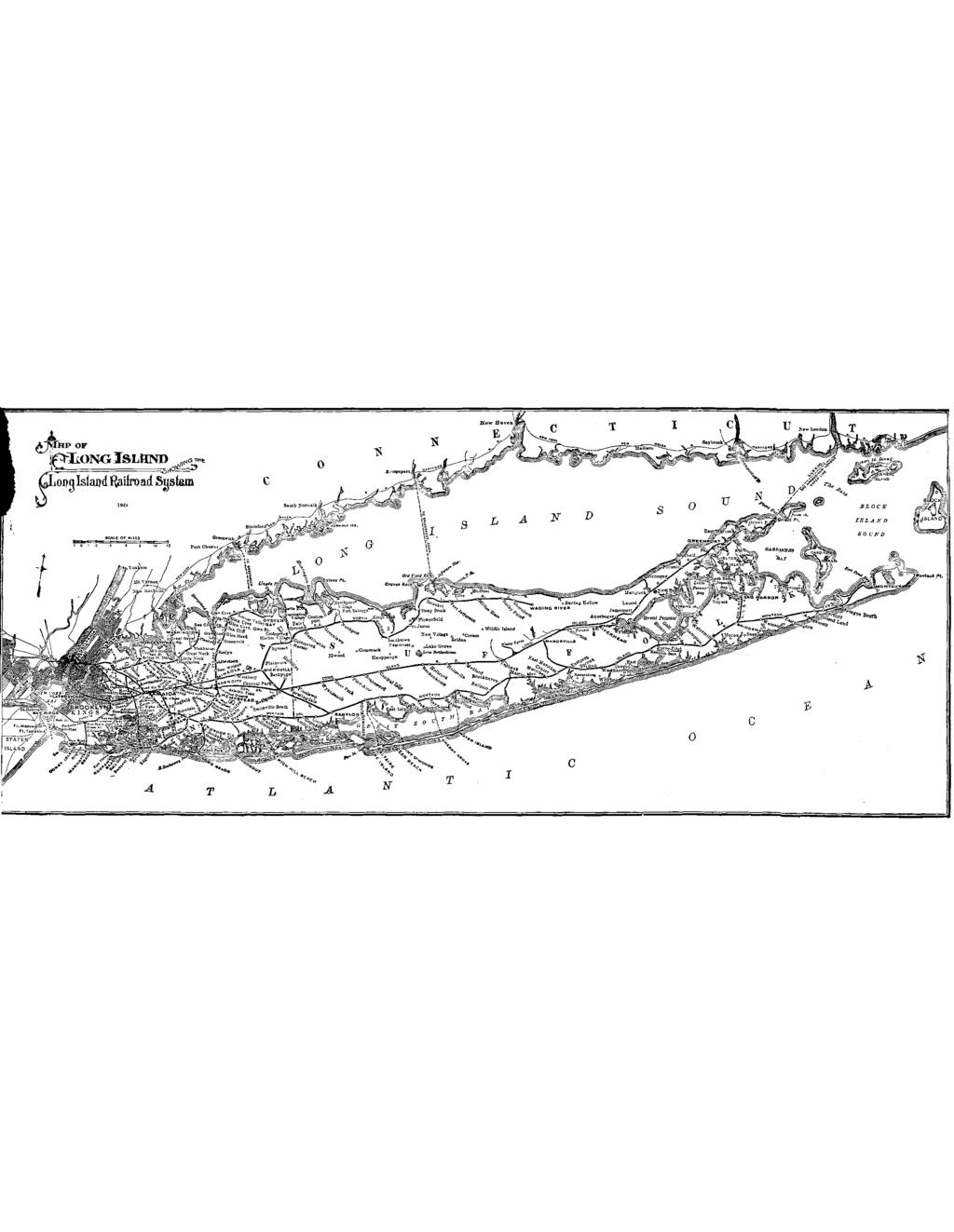
5 THE PICTURE The reels have been prepared long before motion pictures were thought of. We can take in the picture as the car rolls along, if we possess the key to the plan which is unfolding before our eyes. Without the key we can only see in the scenery here and there an old house. This guide book is the key. It deals with the landmarks on the line of the Montauk Highway, which extends to the end of the island, more than a hundred miles in length. This road is at all times used by a great number of motorists, in the western portion through the counties of Queens and Nassau. The person in charge of an automobile has to keep his eyes fixed upon the cars in front and on the side of his own machine. After the county line has been passed and the first towns in Suffolk County, Babylon and Islip, have been passed, the traffic becomes more of a local nature and decreases in volume. Guide books to the landmarks along the other roads are in preparation and will be published either separately or combined in one volume. TOVt7NS AhTD VILLAGES While conversing with other people on his journeys over the island, the writer has found that a few words of explanation regarding the territory traversed by the Montauk Highway might be helpful. This applies particularly to strangers who are touring the island. The road has feeder lines, such as Queens Boulevard, which runs from the Queensboro Bridge through what was
6 6 LASDMARKS ON THE MO~TAUK HIGHWAY known as Long Island City and the town of Newto:vn. People coming from Brooklyn generally use Hillside Avenue. Merrick Boulevard runs from Jamaica village through the former town of Jamaica in Queens County and the towns of Hempstead and Oyster Bay in Nassau County. From the Suffolk County line the South Country Road continues the highway through the towns of Babylon, Islip, Brookhaven, Southampton and Easthampton. The road is now over its entire length known as ~ontauk Highway. The towns are divided into school districts and within the limits of each town are various distinct settlements, commonly called villages. There is a village in every one of these towns, which bears the same name as the town, but occupies only a small portion of the town's territory.
7 NASSAU COUNTY There is one landmark in this county, in the town of Oyster Bay, which we must consider. Just before Massapequa Lake is reached, will be noticed on the south side of the road, The Floyd-J ones Family Burial Place Across the lake, on the north side of the road, stands the white mansion erected in 1837 by David S. Jones. When this building was erected, the Old Brick House, said to have. been built in 1695 by Thomas Jones, thefirst settler on Fort Neck, was taken down. The grave of William Jones, son of Thomas Jones, who was born in 1708 and died in 1779, occupies the northwest corner of the burial place. SUFFOLK COUNTY TOWN OF ISLIY The first object to attract the attention is a little chapel on the north side of the road, just a little east of Oakdale Station, surrounded by trees. It is St. John's Protestant Episcopal Chapel built about 1769, near the center of the patent granted to William Nicolls. It was erected by a descendant of the grantee and rebuilt and enlarged in 1842.
8 8 LANDMARKS ON THE MONTAUK HIGHWAY TOWN OF BROOKHAVEN Having passed through the towns of Babylon and Islip, with only one landmark to be looked up we now enter the town of Brookhaven. In Patchogue is standing, on the north side of the road, a one-story and attic building of the old type, The Case Homestead at what is now locally known as No. 343 East Main Street, just west of Case Avenue. The Grist Mill at East Patchogue, on the north side of the highway, on Swan Creek, shingled and painted red ; hip roof.
9 LAXDIMARKS OhT THE MONTAUK HIGHWAY 9 The mill was owned by the Roe family and subsequently became known as Swezey's Mill. The Avery House east of Swan Creek, on the north side of the road and west of the railroad crossing, one story and attic, shingled, + painted grey; hip roof; built about Now known as Swan River Nursery. The Little Robinson House stands across the railroad tracks, on the south side of the road ; one story and attic, shingled and unpainted. The former Methodist Church a long, one'story and attic structure, shingled and painted red, is standing north of the road, just out- GRISTMILL, EAST PATCHOGUE
10 10 LANDMARKS. ON THE MONTAUK HIGHWAY side the village limits of Bellport. In the central part of Bellport vi!lage, on the northeast corner of Railroad Avenue, stands a shingled, red painted house. Th' is was Howell's General Store three-quarters of a century ago; now a drug store. Bellport Lane continues Railroad Avenue southward from the highway. Near the corner are two hotels on the east side; Hotel Bellport and adjoining on the south is the Bell Inn. The last named, a tall, white building, was formerly The Thomas Bell Residence Bellport was named for Thomas and John Bell. Thomas Bell erected his house in As a public house it was first known as Bell House, later on Mallard Inn and finally Bell Inn. The Captain Seaman House subsequently known as Caroline Hawkins House, a one-story and attic, shingled house, stands on the north side of the road, east of Brookhaven Village, in the district of South Haven. The house was built about Samuel Hawkins came from New York to this place over a century ago and purchased this property. At South Haven, the church stands on the south side of the road and the Carman House on the opposite side, at the point where the road to Yaphank, also called Gerard Road, branches off.
11 LANDMARKS ON THE MONTAUK HIGHWAY I1 'The Presbyterian Church shingled and painted white, was built about 1740 and rebuilt in 1828, the old frame being used and enlarged. The church yard in the rear, 50 by IOO feet, contains a score of tombstones. The Carman House and painted white, was kept as a tavern in the stage-coach days. Along this house runs a lane north east from the road to Carman's Grist M ill The latter is almost completely hidden by the house. This mill, a shingled, unpainted structure, standing on Carman's River, was purchased by one Havens in 1745 and was later owned by the Carman Family. At the eastern end of Centre Moriches will be noticed, on the north side of the highway, a long shingled building of an earlier period. It adjoins the Maplewood farmhouse on the east. The house was moved to this site about 1921 from West Moriches where it had been known as the R. B. Smith House about seventy years ago and later as Murdock House. Just east of the above, also on the north side and in the bend of the road stands a long, two-story and attic, shingled buiiding, guarded by old trees. This was T. V. Ketcham's Hotel a roadhouse of the earlier days. It is now an antique shop. When approaching Terrell's River, the
12 I2 LANDMARKS ON THE MOhTTAuK HIGHWAY A. Barnes House shingled and painted white, will be noticed on the west side of the river, a little north of the road. Directly on the north side of the road, close-by, stands the Gristmill shingled and painted red and at one time operated by Barnes. Then the river was called Barnes' Mill Pond ; however, the name Terrell's River has been restored. The house and mill are within the bounds of East Moriches. TOWN OF SOUTHAMPTON We now enter the town of Southampton. On the north side of the road, east of the Westhampton Methodist Episcopal Church, stands a - Jagger House shingled, unpainted, hip roof. The extension, however, has a peaked roof. Brouwer's Castle at Pine Wold Park, built in more recent times, attracts the attention of every one passing by. It stands south of the road, just west of the mill. The Beaverdam Gristmill on the south side of the road, partly shingled, was built about 1747 and was operated by the Howell family and subsequently by the Homan family.
13 LANDMARKS ON THE MONTAUK HIGHWAY I3 The Brewster House at Quiogue, west of Quogue viliage, is standing north of the road. A curiously looped tree in front of the house attracts attention. Having passed Hampton Bays station, formerly called Good Ground, the highway crosses the railroad tracks. Now comes into view, between the highway and the railroad, a little enclosure, marked Indian Grave It is the last resting place of the Rev. Paul Cuffee, a native Indian preacher, a member of the Shinnecock tribe. He was born in I 757 and died in I His little chapel is standing on the road leading southward from the inn, it having been moved from its original site in the woods, near the grave, to this place. The Indian Burying Ground, in which the chapel stood, was obliterated when the railroad was built about 1867, but the preacher's grave was spared. Canoe Place Inn stands on the north side of the highway, on the west side of the canal which connects Shinnecock Bay with Peconic Bay. Jeremiah Culver established the inn in 1739, on land granted by the English Queen on the condition that a tavern be erected thereon and to be maintained forever. Until the Revolutionary War this was the only habitation between the villages of Riverhead and Southampton. Jeremiah Culver kept the inn as late as 1771 ; Major George Herrick was the host during the days of the Revolution. He sold to John Howell and Howell sold to Israel Conkiing. The

14 SHIP-FIGURE HERCULES original inn was destroyed by fire in 1921 and the present building was immediately erected. Across the roadway is another landmark of peculiar interest. It is The Ship-figure Hercules of the U. S. Ship Ohio. There was a 120 gun ship of that name built in the Brooklyn Navy Yard under Henry Eckford, which was launched in The ship from which the figure was salvaged was lost, the writer believes, in However, the figure, which weighs over a ton, again escaped destruction by the fire which consumed the inn., The road runs now through the Shinnecock Hills,
15 LAXD-MARKS ON THE MONTAUK HIGHWAY 15, which were, until 1859, the abode of the few surviving families of Indians. They are now living on Shinnecock Neck, between these hills and Southampton village on the south of the road. Near the country residences in the hills are standing several remodelled Windmills One of these stood formerly on Windmill Lane, near Main Street, in Southampton village. SOUTHAMPTON VILLAGE Through Southampton village the Montauk Highway takes in a bit of Main Street and continues along Hamp ton Road. The Presbyterian Church stands on the southeast corner of Main Street and Meeting House Lane ; built about 1843, shingled and painted white. The William Rogers House stands on the same side of the street, just north of the lane in the center of large grounds, upon which business buildings have of late encroached.. The original part of the building is old, having beer, built by William Rogers, but the house, which is painted white, has been remodelled. Just west of the Rogers House stood until the spring of 1925 a very interesting landmark. This was the former edifice of the Presbyterian Church, shingled and painted white. It had been erected in 1707 on the northeast corner of Meeting House Lane, directly
16 opposite the present Presbyterian Church and south of the Rogers House. A steeple, reared on the outer front of the building in 1751, was taken off again about When the new edifice was erected, the old one was sold to the Methodist Society, who moved it to the new site where they occupied it until I 883. In the following year the former church became the Village Hall and finally was occupied by a stationery store. In January, 1925, fire destroyed the interior and the rmf and after a few months the ruin of the venerable structure was taken down. The Captain White House shingled and unpainted, occupies the first lot outside the village limits, on the northeast corner of Hampton Road and Flying Point Road. From here the road leads to Water Mill, formerly called Mill Neck. About six hundred feet west of North Cobb Road, on the north side of the road, stands the former Goodale Road House shingled and painted white. The rear of the building was never painted and retains the old appearance ; the house is now occupied by a tea room. The road crosses Benedict's Creek, on 'which can be seen a little to the north, the former Benedict's Mill John Benedict purchased the structure in 1815 and established a woolen mill. The building is now also occupied by a tea room.
17 LANDMARKS ON THE MONTAUK HIGHWAY 17 The Watermill Windmill stands in the Park on the south side of the road. This mill was in 1820 brought to this point from Sag Harbor. T. Halsey operated the mill fifty years ago. The Hamptons always suffered from the lack of waterpower and, just prior to the Revolutionary War, windmills were first used on the east end. The Burying Ground also on the south side of the road, and on the west of 'the church, was established in The former Warren Road House stands just east of the church and of the road leading to the railroad depot. BRIDGEHAMPTON The road now enters Bridgehampton, which embraces several settlements. The first to come into view is Hay Ground; the next Bull's Head, and finally Poxabogue. There are two other settlements within the limits of Bridgehampton, viz: Mecox and Sagg, alias Sagaponack. Mecox and Sagg are in the southern part of the district and are not touched by the Montauk Highway. At Hay Ground is the old, shingled and unpainted S. Rose Farmhouse on the north side of the road, on Rose's Hill, west of Scuttle Hole Road, which runs to Sag Harbor. he white, square building, with columns on its front and known as the

18 18 LANDMARKS ON THE M0KTA.UK HIGHWAY R. D. Rogers House stands north of the highway, on the Mill Road. The former little Hay Ground School House has found a place of honor on the left side of the mansion. Just to the east and a little north of the road, on Hay Ground Hill, is standing the Hay Ground Windmill erected in I 801 by General Abraham Rose and other residents of this vicinity. In the rear stands the little Topping farm house, shingled and unpainted. During the 19th century the Topping family operated the mill. The wings of the mill were badly damaged by the storm in 1924 which felled hundreds of stately old trees on the east end of the island. The miller's house is no longer occupied and the mill and the HAY GROUND WINDMILL
19 LANDMARKS ON THE MOKTAUK HIGHWAY 19 dwelling present a very impressive picture of another period. The Hay Ground Burying Ground is just east of the mill, where the Mill Road begins its semi-circle on the north side of the highway. Just before the One Mile Stone is reached, on the east of Kelly's Pond, will be noticed, on the north side of the road, the Abraham Halsey Farmhouse shingled and unpainted. One mile more and the Cross Roads are reached. This was the centre of the old Bull's Head settlement and is now the business centre of Bridgehampton. But before the centre is reached, comes into view the old Haines House on the northwest corner of Butter Lane. The house was built in 1679, two stories in front and one story rear. Just a century later it was altered into a two- story house; it does not show its great age. The Methodist Episcopal Church painted white, stands on the southeast corner of Halsey's Lane. Built in I 833, in the vicinity of the Pres- byterian Church, the edifice was moved in 1871 to this site. The Presbyterian Church painted white, was built in 1842 and is standing on the south side of the road west of Ocean Road. At the Cross Roads, on what is now known as the
20 20 LANDMARKS ON THE MONTAUK HIGHWAY FORMER EULL'S. HEAD TAVERN, BRIXEHAMPTON northwest corner of Lumber Lane, is standing the former Bull's Head Tavern shingled and painted white. It was? built by John Wicks, probably in That year has been found
21 LANDMARKS ON THE MONTAUK HIGHWAY 2 1 inscribed in a stone in the chimney. Wicks kept the tavern until his demise in The Turnpike Road from Bull's Head to Sag Harbor was constructed in 1833, and this road and Lumber Lane meet the Montauk Highway here and are continued southward by Ocean Road. The house on the northeast corner of Sag Harbor Turnpike was formerly known as the A. T. Rose House County Judge Abraham Topping Rose, who was born in 1792, erected the house and died here in I 857. On the southeast corner of Ocean Road stands the white painted building originally known as Nathan Rogers House The building was erected by the artist Nathan Rogers, who died in I 844. It is now known as the Hampton House. The Sayre House shingled, is standing on the south side of the highway, east of Ocean Road and was built about the end of the 18th century by Captain Nathan Post. The Henry Howell House shingled and painted grey, stands on the north side of the road, about one hundred feet east of Norris Avenue. Part of the former Academy Building is standing on the north side of the road, west of the cross roads at Poxabogue, a1 tered in to a dwelling. The
22 22 LAXDIMARKS ON THE MONTAUK HIGHWAY Academy was situated on the east side of Ocean Road near Sagaponack Road. It was founded in 1859 and existed until The other portion of the building is standing now on the north side of Sagaponack Road. The Le Page Topping House shingled and painted red, stands on the northeast corner of the road to Sag Harbor, at the Cross Roads, Poxabogue. The house was erected by the Pierson family at the end of the 17th century and was for a time owned by Mrs. Russell Sage. On the southeast corner of Sagg Main Street, which continues the Sag Harbor Road southward to Sagg, alias Sagaponack, is the. Poxabogue Burying Ground and adjoining is the Tyndal House, shingled and unpainted. Looking north from the Cross Roads, one can see the old Howell House on the west side of the Sag Harbor Road. The house, which was in 1718 owned by Edward Howell, stood formerly on the east side of the road. Just south of the highway and the burying ground on the east side of Sagg Main Street is the Haney House shingled and painted white. The house was part of the Town Poor Farm, located here before the Suffolk County Poor Farm was established in 1871 atyaphank.
23 On the opposite side' of Sagg Main ~tree.t stands.the old house known as Elisha 0. Hedges House ' shingled, unpainted, two stories front. and one story rear. Further east, on the north side of the highway and on a private lane, is the N. 0. Hedges House probably built in Mrs. Russell Sage purchased this house, which is believed to have been built -by one of her forbears. The house had been of the two.stories front and one story rear type, and has been remodelled. Mrs. Sage first purchased the Le Page Topping House, but found in old records that the last.. LE PAGE TOPPING HOUSE, POXABWUE..
24 23 LANDMARKS ON THE MONTAUK HIGHWAY named house was not built by her ancestor, but was occupied by him while he was building the N. 0. Hedges house. Midway between Bridgehampton and Easthampton, on the west of Georgica Pond, is standing on the south side of the road the shingled and unpainted house known as Captain John Dayton House The building has been remodelled and is now the Gardener's Cottage on the Herter Place. Captain John Dayton occupied the house in the days of the Revolutionary War and bullets fired from a British ship in the bay, are still imbedded in one of the doors. TOWN OF EASTHAMPTON EASTHAMPTON VILLAGE The Montauk Highway takes in Easthampton Main Street which runs in a northerly direction. Most of the houses on this street, one and a half mile long, are of historic interest, On the south end is the Town Pond; on the west side of the street, opposite the pond, stands the former Osborne House Since 1686 the property had been in the Osborne family, who kept here for many years a boarding house. The house was sold in 1925, has been remodelled, and is now known as the Maidstone Arms. The old
25 LANDMARKS ON THE MONTAUK HIGHWAY 25 Burying Ground adjoins the Town Pond on the north, and here are many monuments of historic interest. One was erected to the memory of Lionel Gardiner, the first owner of ~ardiner's Island. Nearby is the last resting place of the body of Colonel Abraham Gardiner, who was born in 1721 and died in Then there is the monument erected for the Rev. Samuel Buell, D.D., who was born in 1718 and died in He served the Easthampton Church fifty-two years as pastor. The crew of twenty-one men who lost their lives in the wreck of the ship John Milton, Captain Hardl 4 ing, in 1858, at Montauk, are buried in a common grave at the north end of the grounds. North of.the Burying Ground, on the east side of the road, is Gardiner's Windmill and a little north of the mill is the stone edifice of St. Luke's Protestant Episcopal Church. Just north of the church stands the John Howard Payne House universally known as Home, Sweet Home. John Howard Payne, born in 1792, spent his childhood here. He died in The house is probably two centuries old, two stories front and one story rear, shingled and unpainted. The Windmill in the rear of the house, stood originally on the Village Green ; was thence moved to a point opposite the
26 Hookmill, on the south side of Amagansett Road. There it was operated by David Hedges. Finally, the present owner of the Payne House moved the mill to this site. The weather vane which surmounts the structure bears the inscription The John Henry Mulford House is standing next to the Payne House, on the north. was built in 1680, two stories front, one story rear, shingled and unpainted. Clinton Academy was erected in 1784 by the Rev. Dr. Samuel Buell on the west side of the street, north of Buell's Lane alias Sag Harbor Road. The academy was named in honor of the first Governor of the State of New York, George Clinton. The building was in 1886 remodelled into It
27 Clinton Hall and is now used as Town Hall. Just across the.highway on the east side of the road, stood until 1861 the old edifice of the Presbyterian Church erected in In this edifice Drs. Samuel Buell and Lyman Beecher used to preach. Further north stands another old Osborne Homestead on the west side of the street. It stood originally on the street line, but has been moved to the rear of the lot. Nearly opposite, on the east side of the road, stands the former Dr. Huntington House shingled and painted a grey color. Its gable end faces the street. This was the home of Captain Thomas Wickham in In the early part of the 19th JOHN HOWARD P.4YNE HOUSE, EASTHAMPTOX
28 Century Dr. Abel Huntington purchased the property and his descendants occupied the house until The building played a major part in the story entitled Sea Spray. An occupant of this house, a daughter of Dr. Huntington, wrote the book. Further along the east side of the street are the Presbyterian Parsonage and Church and on the southeast corner of David's Lane stands the chapel. The parsonage is standing just south of the church and was for many years occupied by the Isaacs family as a boarding house. The church was erected in The parsonage and church are shingled and painted white. The Colonel Abraham Gardiner House is standing on the west side of the street, two lots further north in the rear of the grounds. The Colonel erected the house in 1742 to Among its temporary occupants were Gov. Tryon, Sir William Erskine, Lord Percy and Sir Henry Clinton. Until 1924 the. house stood on the street line; The No Huntting House on the southeast corner of HunttingYs Lane is now known as The Huntting. - Dr. Lyman Beecher's Residence was the shingled house painted a greyish color, on the northeast corner of the same lane. Dr. Beecher served the Easthampton Church as pastor from 1799 until 1810 or 'I I, when he.removed to Litchfield, Conn.
29 LANDMARKS ON THE MONTAUK HIGHWAY 29 The Charles Edwards House shingled and now painted white, two stories front and one story rear, stands with its gable to the street on the east side, just south of Fithian's Lane. The house is said to have been built in the 17th Century and was in 1924 occupied as a tea room. The John Fithian House also on the east side of the road, opposite Newtown Lane has been rebuilt and is now known as the Masonic Temple. Here ends Main Street and the highway runs now along the line of Amagansett Road. A Windmill, formerly operated by the Dominy family, is known as The Hook Mill It stands at the point wherethe road forks. Amagansett Road being the southern branch and North Main Street the northern branch. On the west side of the latter, not far from the mill, stands the old Dominy House between the railroad tracks and the Old Road to.north- West. Worn out millstones form the steps in front of the old homestead. However, our road runs along the southern branch in an easterly direction. On the south side of the road, at its junction with Egypt Lane, will be noticed a reminder of other days, a Whale-Rib Gate leading into the grounds of the residence on that point. On the north side of the road, a little east, is standing
30 30 LANDMARKS ON THE MONTAUK HIGHWAY EDW-4RD BAKER HOUSE, EASTHAMPTON one of the old-time, two stories front and one story rear houses, shingled and unpainted. The Edward Baker House built about A Dr. Hutchinson soid the house in 1767 to the Baker family, who are still the owners. At Pantigo is standing the old Dickerson House just west of the fork in the road, on the south side. AMAGANSETT The highway takes in Main Street of Amagansett. 'The houses on either side are nearly all landmarks, however, only a few can be enumerated. On the south side of the street stands a house which attracts at once
31 LANDMARKS ON THE MONTAUK HIGHWAY 31 the attention of the wayfarer, especially if he is artistically inclined. The E. J. Cartwright House is one of the old homesteads, shingled and unpainted, two stories front and one story rear. The side of the. house and part of the roof are covered with vines. Apparently the house was built as it stands to-day, fating west. It seems to be the exception to the rule. The early houses were built to face the south,no matter whether the front or side came to face the road on that account. The second house east of the Cartwright House on the same side is known as the E. J. CARTWRIGHT HOUSE, AMXGANSETT
32 Jeremiah T. Parsons House It is shingled and unpainted and n3w used by the Roman Catholic Church. The J. B. Conklin House is standing on the north side of the road, nearly opposite the Parsons House; shingled and unpainted. The Presbyterian Church standing on the southwest corner of Meeting House Lane, was built in Across the lane, on the southeast corner is the Parsonage formerly the T. J. Mulford House, shingled and painted white. On the eastern end of Amagansett Main Street, on the north side, are Two Houses of the Hand Family shingled and unpainted. The westernmost was, threequarters of a century ago, occupied by Nathaniel Hand's General Store. The other became known as the Morris Hand House. East of these houses stood formerly the Windmill, last operated by Abraham Parsons. Subsequently the mill was moved to the west side of Windmill Lane, north of West Main Street (just before the turn into Amagansett Main Street, on corning from Easthamptonj. There the mill stood until fire consumed the old structure in July East of Main Street is the Railroad Station. The
33 LANDMARKS ON THE MONTAUK HIGHWAY 33 first train passed through here on its way to Montauk on December I 7th, I 89 j. On the south side of the highway, here locally called Montauk Road, stands the Captain Jonathan Edwards House A few more houses of the smaller type on either side are passed and now you see the Devon Colony on the height on your left. Then suddenly you see before you a different world, the sand-dunes of Napeague Beach There is the Amagansett Life Saving Station on the ocean and the road enters the peninsula of Montauk. MONTAUK Fifty years ago there were on Montauk the three houses built for the shepherds and the men who had charge of the horses and cattle on the peninsula. Then there was the light house and the light keeper's dwelling. The three Shepherd houses were known as the First House, the Second House and the Third House. All three as well as the lightkeeper's house were used by travelers as stopping places over night.
34 34 LANDMARKS ON THE MONTAUK HIGHWAY The First House stood on the north side of the road, about seven miles east of Amagansett. Shingled, unpainted, the house was built in 1702 by Samuel Hedges, who was a carpenter by trade. He became the first occupant of the house as shepherd and he is remembered as Governor Hedges of Montauk. His two sons succeeded him in the work. The house stood until fire destroyed it in 1908 or '09. The foundations remain and some fence posts are standing. West of the'site of the house is a pond and.west of the pond is the Burying Ground containing thirteen tombstones, the oldest dating from 1765 and the last of Three miles farther east is the Hither Plain Life Saving Station with its Lookout upon an elevated point, where the latter was erected during the World War. Parsons' Inn, Cottages and Garage are nearby on the north side of the road. One of the cottages was formerly the Wireless Station of the U. S. Naval Base, established in 1914 on the east side of Fort Pond. The Second House is standing on the north side of the road and on the west side of Fort Pond. Built in 1798, shingled and unpainted, the house is now the country place of a resident of New York City.
35 LANDLMARKS ON THE 51OSTAUK HIGHWAY 35 The Naval Base W E SECOND HOUSE AT MONTAUK across the pond, became Camp Welsh in The camp was abandoned in Only the concrete foundations remain. Further along the Ditch Plain Life Saving Station will be noticed, on the ocean. On this stretch of the coast between the Second House and this station the ship John Milton was wrecked in About four miles east of the Second House is standing on the north of the road The Third House built about his youngest of the Shepherd houses has figured prominently in newspaper reports in the spring of 1925.

36 The Houses of the Montauk Proprietors are to the south, but can be seen from the road. At the Point is the Lighthouse built in 1795 upon Turtle Hill. The upper part was added in the days of the Civil War. The lightkeeper's house stands close by. A Windmill standing on high ground, a little distance west of the lighthouse, was a few years ago transplanted to this site from the Hamptons by a resident of Suffolk County. When the lighthouse is reached the eastward journey is ended. The only possible way to travel now is west- MONTAUK LIGHT
37 LANDMARKS ON THE MONTAUK HIGHWAY 37 ward. Little trouble will be experienced, on the return trip, in locating the landmarks. They become old friends of the traveler, who takes an interest in these veterans, surprisingly quick. To the writer they have become old friends like the books in his library and he is now able to read some of their number like books.. However, the process of reading these landmarks differs greatly from that of reading books. Like everytbng that seems impossible to the unexperienced, this art can only be acquired by practice. In conclusion the writer wishes to state that he feels assured that everyone who by any chance peruses this little book will be more interested in these old houses, when he passes them on future trips. It does not matter, how little he may care for old houses, his vision will be changed. He could not, if he wished to, look upon them "with the same eyes" as he did on earlier trips.

38 LONG ISLAND DIRECTORY Whenever figures are available the population is stated according to the Census of 19 and In some instances estimates of 1925 are added. The population of Long Island was in 1900: 1,452,611 ; in 1920; 2,723,764. KINGS COUNTY Area 77 square miles. This county was organized in 1683, - containing then six towns. Population in 1900: 1,666,582; in 1920: 2,018,356. Town of Brooklyn: Settlement was started in The town was organized in In 1816 a small portion of the town became the Village of Brooklyn. In 1834 the entire town became the City of Brooklyn. The city was in 1855 enlarged by the territories of Williamsburgh and Bushwick. In 1886 was added New Lots, in 1894 Flatbush, New Utrecht and Gravesend, and in 1896 Flatlands. In 1898 the City of Brooklyn became a part of the City of New York and is now known as the Borough of Brooklyn. The histo* of the other towns is as follows: BUSHWICK was originally called Boswijck. Settlement was begun in The village of Boswijck was laid out in FLATBUSH was originally known as Vlakkebos alias Midwout, the town was settled in FLAI'LAXDS was originally called Nieuw Amersfoort and was settled in GRAVESEND was originally called Grauwezaande and was settled in NEW LOTS had been the New Lots of the town of Flatbush since 1654, became a separate town in NEW CTTRECHT was settled in WILLIAMSBURGH was taken from the town of Bushwick in 1840, the village of Williamsburgh was established in 1827, while still a part of the town of Bushwick. The City of Williamsburgh was created in BOROUGH HALL BOOKE SHOPPE 337 Adams St.. Brooklyn Books bought and sold Tel. Triangle 3945 QUEENS COUNTY Area: 130 square miles. This county vas organized in 1683, containing then six towns. In 1899 a part of Queens County was made a separate county under the- name of Nassau County. The remainder had become a part of New york City, under the name of Borough of Queens in Population in 1900: 152,999; in 1920: 469,042.
39 LONG ISLAND DIRECTORY 39 NEWTOWN This town was originally called Middelburgh, and was known in as Hastings. An earlier settlement in this town, known as Mespat, had been started in 1642 and was destroyed in the Indian War of the following year. Population estimated in 1923: 229,000. Newtown is now known as the Second Ward of the Borough of Queens. Villages: Corona, Elmhurst, Winfield and Woodside. Forest Hills and Jackson Heights are settlements of more recent origin. LONG ISLAND CITY was taken from the town of Newtown in 1872; became a part of the City of New York in 1898 and is now known as the First Ward of the Borough of Queens. Population, 1900: 58,794 ; 1923 : estimated 130,000. Villages: Hunter's Point, Ravenswood, Astoria, Dutch as ills and Blissville. WM. D. BLOODGOOD & CO.. Inc. Factories, Factory Sites and Acreage Bridge Plaza South Long Island City FLUSHING Was originally called Vlissingen and was sett:ed in 1644; was in called Newwark. Became in 1898 a part of New York City and is now known as the Third Ward of the Borough of Queens. Population, 1923: estimated 88,000. Villages: Auburndale 1925: 900; Bay Side 1900: 700; 1925 : 11,500; Broadway ; College Point 1900: 7000; 1925 : 20,000; Douglaston I*: 432; 1925: 3,635; Flushing: 1900: 9700; 1925: 47,500: Little Neck 1900: 700; 1925: 1,870; Malba, Murray Hill, Whitestone, 1900: 4,2m ; 1925 : 10~9~0. -. JAMAICA Was originally called Rusdorp ; this town was settled in 1656; was in called Crawford. Became in 1898 a part of New York City and is now known as the Fourth Ward of the Borough of Queens. Population 1923: estimated 250,000. Villages: Hollis, Jamaica, Ozone Park, Queens, Richmond Hill, Springfield and Woodhaven. There are many settlements in this town of more recent origin, such as: Bellaire, Bellerose, Brooklyn Manor, Cedar Manor, Hamilton Beach, Higbie Avenue, Hillside, Kew Gardens, Locust Avenue, Morris Park, Queens Village, Rosedale, St. Albans, Union Course and West Bridge. BOCKAWAY PENINSULA Was taken from the town of Hempstead and became in 1898 a part of New York City. It is now known as the Fifth Ward of the Borough of Queens. Population 1923: estimated 39,ooo. Villages: Arverne, Edgemere, Far Rockaway and the various parts of Rockaway Beach, as: Hammels, Hollands, Rockaway Park and Seaside. NASSAU COUNTY Was in 1899 taken from Queens County and made a separate county. Area: 252 square miles. Population, 1900: 55,448 ; 19-0: 126,120.
40 4O LONG ISLAND DIRECTORY HEMPSTEAD Was originally called Heemstede and was settled in 164 In 1784 the town was divided into South Hempstead and North Hempstead. In 1796 the town of South Hempstead was renamed Hempstead. Population 1900: 27,066 ; 1920: 70,790. Villages: Baldwin, Bellmore, Cedarhurst 1925: 3,480; East Rockaway, 1900: 739; 1920: 2,005; Floral Park, 1900: 500;. 1925: 64.60; Freeport, 1900: 2,612 ; 1920: 8,599; 1925: Garden City, 1920: 2,420; Hempstead, 19co: 3,582; 1920: 6,382; 1925 : 9,940; Hewlett, 19: 371 ; Inwood, Lawrence, 1900: 558 ; 1920: 2,861 ; 1925: 3,050; Lynbrook, 19m: 1,605; 1925: 10,645 ; Malverne, Merrick, Oceanside, Rockville Centre, I 900: 1,884 ; 1920; 6,262; 1925: 10,085; Roosevelt, Seaford, Stewart Manor, Valley Stream, 19co: 800; 1925: 7,830; Wantagh, Woodmere, 1925, 2,530- There are settlements of more recent origin, such as Country Life Press, Nassau Boulevard, Hempstead Gardens, Island Park, South Lynbrook and West Hempstead. Long Beach became a city in 1922; population in 1925: 7,290. NORTH HEMPSTEAD Was established in 1784, being set off from the town of Hempstead. Population 1900: 12,?48; 1920: 26,370. Villages: Albertson, Carle Place, East Wlll~ston, Great Neck, Manhasset, Mineola, 1900: 1,014; 1920: 3,016; 1925: -5,260; New Hyde Park, Old Westbury, Plandome, Port Washington, Roslyn, Westbury. OYSTER BAY. Was originally called Oost Baai, the settlement having been started on the easternmost bay of the Dutch possessions on the island. The name became subsequently Oester Bay and finally Oyster Bay. The town was called in Folstone. Population 1900: 16,334 ; 192.0: 20,296. Villages : Bayville, Brookville, Central Park, East Norwich, Farmingdale, 1920: 2,091 ; 1925 : 3,980 ; Glen Head, Greenvale, Hicksville, 1925 : 3,555 ; Jericho, Lattington ; Locust Valley ; Massapequa, Matinecock, Mill Neck. Oyster Bay, 1900: 2,825; Sea Cliff, 1900: 1,558; 1920: 2,108; Syosett; Woodbury. Glen Cove was created a city in 1918, population 1920: 8,664; 1925: 10,100. SUFFOLK COUNTY Was organized in 1683, then containing eight towns. Area: 918 square miles. Population, 1900: 77,582 ; 1920 : I 10,246. BABYLON Was in 1872 taken from the town of Huntington and made a separate town. Population: 1900: 7,112; 1920: 11,315. Villages: Amityville, 1903: 2,038 ; 1920: 3,265 ; 1925 : 4,845 ; Babylon, I9m: 2,157; 1920: 2,523; 1925: 3,990; Copiague, Deer Park, Lindenhurst, 1900: 1,219 ; 1925: 3,345 ; Pinelawn, Wyandanch.?
41 LONG ISLAND DIRECTORY 4* BROOKHAVEN The town was settled in 1655; was first known as Setauket. Town was organized in Population I-: 14,592 ; 1920: 21,847. Villages: Bayport, Bellport, 1920: 614; Belle Terre, Blue Point, Brookhaven, Centre Moriches, Coram, East Moriches, Eastport, Great River, Holtsville, Manorville, Mastic, Medford, Middle ~sland, Miller's Place, Moriches, Mount Sinai, Patchogue, IF: 2,926; 1920: 4,031; 1925: 8,005; Port Jefferson, 1900: 1,854.; 1925 : 3,130 ; Rocky Point, Setauket, Shoreham, Stony Brook, Yaphank. EASTHAMPTON Was originally called Maidstone and was settled in Gardiners Island, which became a part of this town, was settled in The present name was applied to the town about Population 1900: 3,746; 1920: 4,852. Villages: Amagansett, 1900: 650 ; Easthampton, 1900: 1,680; Montauk, W ainscott. PARSONS HOUSE AND COTTAGES Montauk W. D. Parsons Open all year round HUNTINGTON Was originally known as Hunting Town and was settled in Population 1900: 9,483; 1920: 13,893. Villages: Centreport, Commack, East Northport, Greenlawn, Huntington, 1900: 4000; 1925: 15,225 ; Lloyd's Neck, 1900: 216; Northport, 1900: 1,794; 1920: 1,977; 1925: 2,815. ISLIP Was settled in The name Islip was at first applied to the William Nicolls Estate. The town was first recognized by the Colonial Government in Population, 1900: 12,545; 1920: 20,709. Villages: Bay Shore, 1900: 3,092; 1925: 7,110; Brentwood, Brightwaters, Central Islip, East Islip, Hauppauge, Islip, 1900: 1,735 ; I 925 : 3,S30 ; Oakdale, Pineaire, Ronkonkoma, Saltaire, Sayville, 1900: 1,954 ; 1925 : 3,135 ; West Sayville. RIVERHEAD Was in 1792 taken from the town of Southold and was named for the settlement then known as The Riverhead. Population 1900: 1,503 ; 1920: 5,753. Villages :.4quebogue, Calverton, Jamesport, Laurel, Riverhead, Wading River. SHELTER ISLAND Was settled in 1652; called Sylvester's Island in Until 1730 the town was united for governing purposes with the town of Southold. Population, 1920: 890; 1925: 1,500. SMITHTOWN Was originally called Smithfield and was settled in Population, 1900: 5,863 ; 1920: 9,114. Pillages : Flowerfield, Fort Salonga, Kings Park, Smithtown, Smithtown Branch, St. James.
42 4* LOKG ISLAND DIRECTORY SOUTHAMPTON Was settled in Population 1900: 10,371 ; 1920: 11,614.- Villages : Bridgehampton, East Quogue ; Flanders, Hampton Bays, Quogue, Sag Harbor, 1900: 1,969; 1920: 2,993; 1925: 3,360; Southampton, 1900: 2,289; 1920: 2,891 ;.1925: 3,205; Speonk, Water Mill, Westhampton. BASSO'S RESTAURANT Southampton "The home of good food" SOUTHOLD Was settled in Population 1900: 10,371 ; 1920: II,~I+.. Villages : Cutchogue ; East Marion ; Greenport, 1900: 2,366 ; 1920: 3,i22; 1925: 3,600; Mattituck, New Suffolk, Orient, Peconic, Southold. MORRELL & HORTON CENTRAL GARAGE Cutchogue Tel. Peconic 14 THEN AND NOW f The latest Federal Census was taken in We can best observe the march of progress on Long Island by comparing the island of 1920 with that of a century earlier. The traveler who in those early days came along the South Country Road did see most of the landmarks noted in this guidebook. Long Island had then 56,978 inhabitants. Of this number 11,187 lived in Kings County; 21,519 in Queens County and 24,272 in Suffolk County. Kings was the smallest and Suffolk the largest. of the counties, both in area as well as populatian. A letter addressed by the Postmaster General to Congress, showing the receipts of the various Long Island Post Offices during the fiscal year of is a document of peculiar inrest. The net amount of postage having accrued at each of these offices during that year, is mentioned as follows: Jamaica $ ; Hempstead $36.57 ; Oyster Bay $23.00 ; Oyster Bay South $7.39 ; Jericho $18.07 ; Jerusalem $1.27; Deer Park $7.37 ; Islip $20.40 ; Patchogue $24.3 I ; Cold Spring $18.63 ; Smithtown $56.16 ; Wading River $2.74 ; Setauk,et $28.46 ; Riverhead $29.40; Mattituck $18.86 ; Cutchogue $10.20; Southold $35.35 ; Oyster Ponds $25.32 ; Sag Harbor $117.06; Westhampton $9.61 ; Southampton $47.62 ; Bridgehampton $50.22 ; Easthampton $ During the fiscal year the total Post Office receipts on the island were less than $2,500, of which amount the Brooklyn Post Office had earned $1,039.3~. The Brooklyn Post Office then occupied a corner in a store and rook care of the entire County of Kings. In 1820 the City of New York was inhabited by 152,056 people and was confined to the Island of Manhattan. The compact portion of the city was south of City Hall. Across the East River was the Village of Brooklyn and'a little further up the river had sprung up the settlement of Williamsburgh around the newly established ferry. The Williamsburgh and Jamaica Turnpike (the present Metropolitan Avenue) had been constructed a few years earlier. The new road and the ferry at its terminus had considerably shortened the distance from

43 LONG ISLAND DIRECTORY 43 the Long Island towns to the markets in the City. Kings County was the next-door neighbor of New York City, and Brooklyn and Williamsburgh grew up with their bigger neighbor. The road to the Williamsburgh ferry was a boon to the Long Islanders who brought the produce of their farms to the city markets, but the general business of the island was transacted in the taverns clustering around Fulton Ferry, Brooklyn. These taverns filled the places of our present day lunchrooms, hotels, banks, law-offices, stores, clubs, theatres, railroad depots, etc. The village extended up to Red Hook Lane, in the rear of the present Borough Hall, and the boundary line ran from the western line of the Navy Yard on the Wallabout to the foot of Atlantic Avenue. Farmhouses were along the roads and in the outlying districts were several settlements around the churches and some residents of New York City had country seats in Kings County. As late as 1840 the present Mansion House in Hicks Street was opened as a summer resort. New Yorkers were invited to send their families to this resort for a few weeks during the summer season. Fulton Ferry was the gateway which led out into the island. Brooklyn became a city in 1834 and Williamsburgh in Four years later Brooklyn absorbed Williamsburgh and the town of Bushwick. The other towns became parts of Brooklyn as follows: New Lots in 1886, Flatbush, New Utrecht and Gravesend in 1894, and Flatlands in Brooklyn City embraced now all of Kings County. In Queens County, Long Island City was carved in 1872 out of that portion of the town of Newtown, which was situated opposite New York City. In 1898 Greater New York came into existence and within the new city limits are now Brooklyn, Long Island City, the towns of Newtown, Flushing, Jamaica and the Rockaway Peninsula. The balance of Queens County became Nassau County. In 1920 the City of New York, Greater New York, had 5,620,048 inhabitants. Long Island had 2,723,764. Of these lived 2,018,356 in Kings County and 469,042 in Queens County, both now parts of the city. Sassau County had 126,120 inhabitants and Suffolk County 110,246. Jamaica Village has taken the position formerly occupied by Fulton Ferry. Such are the changes which have taken place on the island during a century. The country residences and farmhouses in the counties of Kings and Queens are rapidly disappearing. The city forever keeps on reaching out, the demand for homes, factory sites and country residences is always there. The needs of the six million population of New York today are greater than were the needs of the old city which gradually developed from the community of 1820 with a population of 152,056. The foregoing notes may be found useful in speculating on
44 44 LONG ISLAND DIRECTORY the future of the island. The line of least resistance is on the south side of the island. However, every part of the island is reaping its proportionate share of benefit from any improvement, which makes any point on the island more accessible from the city. When the plans of the Long Island Railroad regarding the electrification of some lines were made public about 1906, it was predicted that Lynbrook would remain the eastern end of the electric service on the Montauk Division. Today electric trains are running to Babylon. QUEENS COUNTY Now also the Borough of Queens will surprise even those who always predicted a great future for this borough. The common street system throughout its territory is wiping out the ancient town lines and settlements are springing up simultaneously in every part. The extension of the subway to Flushing will be the great factor in building up the north shore. Wherever a start is made by laying out farmland in building lots, there is no end to it. One farm being built up, the next one is laid out and this march is kept up. In some sections the Nassau County line has been reached. The Queensboro Bridge, Queens Boulevard, the Pennsylvania Tunnels, the Dual Subway lines to Astoria and Corona, and soon to Flushing, the B. M.T. line to Jamaica and the improved service on the Long Island Railroad to Queens Village and further out are powerful means of building up the borough. The south shore will be greatly benefitted by the Rockaway Boulevard starting in Brooklyn. There are so many improvements under way which will mainly work for the benefit of this borough that there can be little doubt that Queens County soon will be as close a part of New York City as any part of the city outside the Island of the Manhattans. There has always existed a suburban advance guard of New York City. There is a certain element, bound by business ties to the city, but not willing to live in the solidly built-up city. These people want, though on a moderate scale, a rural surrounding for their homes. In which county will these suburban settlements be found twenty years hence? NASSAU COUNTY Is the next-door neighbor of Xew York City. Kings Co. held this position until 1898 when Greater New York came into being. The East River was long the barrier which prevented the union of New York and Brooklyn. The construction of the Brooklyn Bridge was the tie which united the two cities. Now Brooklyn people travel daily to New York without getting a glimpse of the river in months. There is no river between New York City and Nassau County. On traveling along
45 LONG ISLAKD DIRECTORY 45 Jericho Turnpike one can notice where the city ends, by the numbered streets. But sooner or later the authorities beyond the line will continue this numerical street system for the convenience of their people and then the last iiark of distinction will be removed. Within five years a similar condition will prevail along the Northern Boulevard. SUFFOLK COUNTY The development of the eastern end of the island has been retarded by an accident. This accident caused the untimely death of Austin Corbin, a man of vision, who saw the possibilities of this part of the island for ocean traffic. He had seen the possibilities of the common pasture land of the Town of Gravesend in Kings County. The portion of this tract, considered to be of the least value, was known as the Sedge Bank. This he purchased and created Manhattan Beach on its site. On the east end he saw the possibilities of Fort Pond Bay as a pag of the Port of New York. If his life had been spared, the railroad line would, in all probability, today be doubletracked and electrified. A multitude of passengers would patronize it all the way to the end of the line. Trains making no stops between Montauk and New York City would carry the oversea travelers to and from the city. The local interests along the line would share the benefit of this improved railroad service. At present the business offered to the railroad does not warrant the expenditure of the vast sums required for such improvement. When the main line was opened to Greenport in 1827, three trains carried the invited guests of the railroad to the eastern terminus of the line. 31 miles were traveled in the first hour. The average speed of the early locomotives was 12 to 15 miles per hour. A special effort was made to give first-class service by the Boston Train which usually made the run from Brooklyn to Greenport in 3% hours. The record time was 2 hours 35 minutes. Two stops were made to replenish fuel and water, at Farmingdale and again near Manorville. In those days wood-burning Iocomotives were in use on the trains which covered the go mile stretch in from 2f/2 to 3 hours. Today electric trains would make the run from Montauk to the city, if no stops were made on the way, in 1% hours. Sooner or later Mr. Corbin's vision will come true. Whether Fort Pond Bay or Three Mile Harbor will be used, remains with the future.

46 Academies Albertso~i 40 A~nagansett 11 Amityville 40 Aquebogue 41 Arverlle -39 Astoria 39 Aul>urnd;~le -4very House... 8 Habylnn. Town of. 40 " Village of 40 Baker House. Ed\\.. 30 Haldwin Ha rnes House. A.. 12 Hayport Hay Shore Ray Side Havville Reaverdam Gristmill Heecher Residence.....-Dr. 28 Rellaire Rellerose elleTerre Hellmore Rellport...lo. 41 Hell Residence Henedict's Mill Hlissville Rlue Point Hrentwood Rrewster H ouse Hridgehamptonl Hrightwaters Broadway Hrookhaven. Town of Brookhaven, Village of Brook1 yn. Borough of Rrooklyn. City of Rtonklyn Manor....r) Brooklyn. Town of.38 " Village of Rrookville Hrouwer's Castle.. 12 Hull's Head...l9. 20 " Tarern 20 Hushwick. Town of.38 '" Village of 38 Calverton Canoe Place Inn Carle Place Carman House Carman's Gristmill 11 Cartwright House. E. J Case Hcmestead... 8 Cedarhurst Cedar Manor INDEX Central Islip Central Park Centre Moriches Centreport Clinton Academy..!26 Cold Spring College Point Commack ConklinHouse,J.R. 32 Copiague....U) Coram Corona Country Life Press 40 Cutchogue...42, 42 Daytori House. Captain John Deer Park Devon... $3 Dickerson House.. 30 Ditch Plain Dominv House Douglaston Dutch Kills Easthampton Buryinz Ground....% Easthampton. -row11 of Easthampton. Village of...%, East Islip East Marion East Moriches...ll. 41 East Pr'orthport East Norwich East Patchogue... 8 Eastport East Quogue East K ockaway East Williston Edgemere Edwards Houses.29, 33 Elmhurst Farmingdsle Far Rockaway First House Fithian House, John Flanders Platbush. Town of 38 Flatlands. Town of 38 Floral Park Flo\.versfield Floyd-Jones Burial C Place... 6 Flushing. Town of 39 " Village 0 f Forest Hills Fort Salonga Freeport Garden City Gardi ner Hocse. Col Gardiner windmill 25 Glen Core. City of 40 Glen Head tioodale Road House Gravesend. To w n of Great Neck Great River (;reenlawn Greenport Greenvale Gristmills... S Hailles House Ha lsey House. A br. 19 Hamilto~l Heach Ham~nels Hampton Bays...l3. 42 Hand tlo~~ses Haney House Haupr>auge Hay Ground Hay Ground Ruryine (;round Hay Grou~ld U7indmill Hedges Houses Hemps teadgardens Hempstead. Town or Hempstead.Vill;rge of Hercules Ship Figure Hewlett Hicksrille Highbie Avenue... :B Hillside Hither Plain Hollands ) Hollis tlnlts\-ille Hookmill H owell Houses " Gen'l Store 10 Hunters IJoint tjunti~rgton House. Dr... Zi Huntington. Town of Hunti~lgton.\'illage of HunttinpH0use.N. 23 Indian Grave Inwood Island Park Islip. Ton n of " Vi1lag.e of Jackson Heights Jagper House Jamaica. Town of Jamaica. Villageof
47 Jamesport Jericho...4i).42 f erusalem C Jones Mansion... 4 Ketcham's Hotel.. 11 Kew Gardens Kings County Kings Park Lattington... M Laurel Lawrence Life Saving Stations...Z Lindenhurst Llttle Neck... :39 Lloyd's Xeck Locust Arenue Locust Valley Long Reach. City of 40 Long Island City.. 39 Directory.39 " Population " Early Post Offices nbrook I alba Malveme Manhasset anorville Massapequa Mastic Matinecock hi attituck Mecox Medford hferrick Methodist Churches Middle Island bi iller's Place Mill Neck Mineola Montauk Burying Ground Montauk Lizht Point " Yroprietors... 3C, >fontauk Village.. 41 " Windmill 36 Moriches hforris Park 3!3 Mount Sinai blulford House 26 Murray Hill 39 Napeague Beach.. 33 Xassau Roulevnrd County..B.44.. xaval Rase Xetv H yde Park New Lots. Town of.% New Suffolk Newtown. Town of.r) New Utrecht. Town -38 Netv York City. population North Hempstead. Town of Northport Oakdale Oceanside Old Westbury Orient Osborne Houses..H. 2i Lb h-eck.. 15 Oyster Bay So~th.7~43 Shorebarn 'I'own 40 Oyster Bay. Village of.40, Oyster Ponds Ozone Park Yantigo... 31) I'arsons House... :E Parsons Inn and Garage Patchogue...S Payne House. John Howard Peconic '' Hay Pine Aire Pinelawn Pine Wold Park Plandome Port Jefferson Port Washington.. 40 Poxabogue " Burying Ground Presbyterian Churches 11,15.13,2?3,32 Presbyterian Parsonages Queens Borough of 38 " County " Village Quiogue Quogue Karenswood Richmond Hill Riverhead.To\vnof 41 " Village of Robinson House.. 9 Rockaway Beach.. 39 " Park... 31) ' Pellin- sula Rockville Centre.. 40 Rocky I'oint Rogers Houses Ronkonkoma Roosevel t R osedale Rose Houses...li. 21 Kosl yn Sapg Sagaponack Sag Harbor Saltaire SayreHouse Say ville Sea Cliff Seaford Seaman House. Captain Sea Side Second House Setauket Shelter Island Shinnec~ck Hay tiills.. 14 Smith House. K. H. 11 Smithtown Branch 41 " Town of 41 " Village of Southampton. Town 42 Southampton. \-illage of South Haven South Lynbrook Southold. Tuwn ot 42 " Village of Speonk Springfield... 3!4 St Albans St James St. John's P. E. P Chapel... 4 Stewart Manor Stony Brook Suffolk County Syosset Terrell's Kirer Then and Now Third House Topping House. 22 Union Course Valley Streal Wading River Wairtscott W7antagh Warre11 Road H'se 17 water Mi Water Mill Burying Ground Water Mill- IVindmill 17 West Hridge Westbury Westbampton...l2.42 West Moriches West Sayville Whale-Rib Gate White House. Captain Whitestone Wi lliamsburgh. City oi Williamsburgh. Town ot ' West Hempstead.. 40 Williamsbureh. Village cjf Windmills Winfield W-ood bury Woodhaven... % Woodmere Woodsitle Wyandanch Saphank... 41
48 Published r 9 I 8- I 924, in edi~ions limited to roo to 300 numbered copies THE INDIANS OF NEW ENGLAND AND NEW NETHER- LAND. Published I 9 I copies. Size 6x9 inches; I I pages. S I. 00 postpaid. SECOND EDITlOE I oo copies. Size 7x I o % inches ; I I pages. $I.oo postpaid. BRUIJKLEEN COLONIE (Borough of Brooklyn), ~ublished too copies. Size 6x9 inches; r I pages with maps. SI.oo postpaid... THE FERRY ROAD ON LONG ISLAND. Published I 9 I copies.. Size 7x I oyg inches ; 40 pages and cover; 6 illustrations and 2 maps. St.00 postpaid. THE WALL ABOUT PRISOh- SHIPS, Published I 92 I. zoo copies. Size.jr I oj,g inches; 29 pages and cover,aith view of the Jersey. S:. oo postpaid. LONG ISLAND LANDMARKS, Part-1.-The Town of Newtown, including Long Island City. Pubhshed copies. Size 7x I I inches ; 5 3 pages and cover. $3.00 postpaid. MONTAUK. Published I 9%;. 309 copies. Size 7x1 I inches ; 8 pages.,s I. oo postpaid. CONEY ISLAND. Published zoo copies. Size 7x I I inches ;..14 pages and cover. S2.00 postpaid. LONG ISLAND. The above mentioned monographs, bound in one volume ; half morocco. SI j.00.postpaid. Copies can be secured by addressing EUGENE L. ARMBRUSTER 263 Eldert Street ~rooklyn, N. Y.
49
Cold Spring Harbor 142 Cold Spring Harbor 142 Cold Spring Station 139 Commack 157 Copiage 145 Coram 194 Cove Neck 136 Cutchogue 266 Deer Park 149
 Long Island City/Town Rate Albertson 90 Amagansett 340 Amityville 141 Apaquogue 329 Apuebogue 194 Arshmonaque 290 Asharoken 157 Atlantic Beach 103 Babylon 153 Baldwin 108 Barnes Hole 349 Bay Park 103 Bay
Cold Spring Harbor 129 Cold Spring Harbor 129 Cold Spring Station 126 Commack 143 Copiage 132 Coram 176 Cove Neck 124 Cutchogue 242 Deer Park 135
 Long Island City/Town Rate Albertson 82 Amagansett 309 Amityville 128 Apaquogue 299 Apuebogue 176 Arshmonaque 264 Asharoken 143 Atlantic Beach 94 Babylon 139 Baldwin 98 Barnes Hole 317 Bay Park 94 Bay
LAKE GROVE (METRO NEW YORK), NEW YORK
, NEW YORK") LAKE GROVE (METRO NEW YORK), NEW YORK A WEALTH OF OPPORTUNITY Smith Haven Mall is positioned within five miles of Long Island Sound and the established, wealthy communities along the north shore of Suffolk
LAKE GROVE (METRO NEW YORK), NEW YORK A WEALTH OF OPPORTUNITY Smith Haven Mall is positioned within five miles of Long Island Sound and the established, wealthy communities along the north shore of Suffolk
SECOND QUARTER 2017 EAST END RESIDENTIAL PRELIMINARY* MARKET REPORT
 SECOND QUARTER 2017 EAST END RESIDENTIAL PRELIMINARY* MARKET REPORT *Based Upon Data Available as of April 22nd, 2017. Final 1Q 2017 Report to be Issued July, 2017. Data Highlights: Second Quarter 2017
LAKE GROVE (METRO NEW YORK), NEW YORK
, NEW YORK") LAKE GROVE (METRO NEW YORK), NEW YORK A WEALTH OF OPPORTUNITY Smith Haven Mall is positioned within five miles of Long Island Sound and the established, wealthy communities along the north shore of Suffolk
LAKE GROVE (METRO NEW YORK), NEW YORK A WEALTH OF OPPORTUNITY Smith Haven Mall is positioned within five miles of Long Island Sound and the established, wealthy communities along the north shore of Suffolk
First Quarter 2018 Market Report I Hamptons + North Fork. Based Upon Data Available as of April 13, 2018.
 First Quarter 2018 Market Report I Hamptons + North Fork Based Upon Data Available as of April 13, 2018. Data Highlights: First Quarter 2018 Cover Property: 8 Fieldview Lane, East Hampton Halstead.com
Senate Alternative (Feb. 9, 2012) Submitted by Todd Breitbart
 Submitted by Todd Breitbart") Senate Alternative (Feb. 9, 2012) Submitted by Todd Breitbart Clinton Franklin St. Lawrence 0 10 20 30 49 47 Essex Jefferson Lewis Hamilton Warren 50 Oswego Niagara Orleans 58 56 Wayne Monroe Herkimer
Senate Alternative (Feb. 9, 2012) Submitted by Todd Breitbart Clinton Franklin St. Lawrence 0 10 20 30 49 47 Essex Jefferson Lewis Hamilton Warren 50 Oswego Niagara Orleans 58 56 Wayne Monroe Herkimer
+8.2% compared $10M 37.7% +17.8% to DATA HIGHLIGHTS: THIRD QUARTER The total number of 3Q17 South Fork sales. increased
 HAMPTONS+NORTHFORK M A R K E T R E P O R T T H I R D Q U A R T E R Based Upon Data Available as of October 13, 2017 DATA HIGHLIGHTS: THIRD QUARTER 2017 The total number of 3Q17 South Fork sales increased
Third Quarter 2018 Market Report I Hamptons + North Fork. Based Upon Data Available as of October 19, 2018.
 Third Quarter 2018 Market Report I Hamptons + North Fork Based Upon Data Available as of October 19, 2018. Data Highlights: Third Quarter 2018 Cover: 29 Knollwood Drive, Southampton.com Web# 105535 The
HAM PTON S+NORTH FORK
 HAM PTON S+NORTH FORK M A R K E T R E P O R T Y E A R E N D 2 0 1 7 Based Upon Data Available as of January 19, 2018 DATA HIGHLIGHTS: 2017 The total number of 2017 South Fork sales increased +10.4% compared
Senate Alternative Revision (Feb. 12, 2012)
") Senate Alternative Revision (Feb. 12, 2012) Clinton Franklin St. Lawrence 0 10 20 30 49 47 Essex Jefferson Lewis Hamilton Warren 50 Oswego Niagara Orleans 56 Wayne Monroe 58 Herkimer Washington Oneida
Senate Alternative Revision (Feb. 12, 2012) Clinton Franklin St. Lawrence 0 10 20 30 49 47 Essex Jefferson Lewis Hamilton Warren 50 Oswego Niagara Orleans 56 Wayne Monroe 58 Herkimer Washington Oneida
CYPRESS HILL SERVICE CENTER 3123 ATLANTIC AVE Brooklyn NY BP 784 JAMAICA AVE Brooklyn NY JAMAICA MANAGEMENT ATLANTIC AVE Brooklyn
 Long Island FLORAL PARK GAS 286 JERICHO TPKE Floral Park NY 11001 SUNOCO 244 LINDEN BLVD Elmont NY 11003 GREENVALE OIL 724 ELMONT RD Elmont NY 11003 LIBERTY 715 HEMPSTEAD TPKE Elmont NY 11003 CITGO 1111
VERIZON NEW YORK INC. Section: 1 P.S.C. No. 16--COMMUNICATIONS Page: 1 Effective Date: May 1, 2014 Revision: 0 Superseding Revision:
 P.S.C. No. 16--COMMUNICATIONS Page: 1 A. APPLICATION OF TARIFF This Tariff contains the schedules of rates and specific regulations applicable to local exchange telephone service furnished within the New
SHEVA GAS 441 UTICA AVE Brooklyn NY HESS UTICA AVE Brooklyn NY R AND I SERVICE CENTER 720 NEW YORK AVE Brooklyn NY BP 756
 Long Island HESS 32493 250 JERICHO TPKE Floral Park NY 11001 HESS 32298 650 ELMONT RD Elmont NY 11003 P&S SHELL SERVICE CENTER 221 HEMPSTEAD TPKE Elmont NY 11003 CITGO 1338 HEMPSTEAD TPKE Elmont NY 11003
Long Island USA GAS 15 TULIP AVE Floral Park NY BELLEROSE CAR CARE JAMAICA AVE Floral Park NY ELMONT 2115 LINDEN BLVD Elmont NY
 Long Island USA GAS 15 TULIP AVE Floral Park NY 11001 BELLEROSE CAR CARE 24040 JAMAICA AVE Floral Park NY 11001 ELMONT 2115 LINDEN BLVD Elmont NY 11003 SUNOCO 244 LINDEN BLVD Elmont NY 11003 HESS 32298
HUNTINGTON (METRO NEW YORK), NEW YORK
, NEW YORK") HUNTINGTON (METRO NEW YORK), NEW YORK ISLAND OF OPPORTUNITY Beautiful beaches. Celebrated history. Fabled riches. Huntington is located in Long Island s Suffolk County, a sweet spot of prosperity. Affluent
HUNTINGTON (METRO NEW YORK), NEW YORK ISLAND OF OPPORTUNITY Beautiful beaches. Celebrated history. Fabled riches. Huntington is located in Long Island s Suffolk County, a sweet spot of prosperity. Affluent
Long Island Power Authority, 333 Earle Ovington Blvd., Uniondale, NY
 2006 Long Island Population Survey Long Island Power Authority, 333 Earle Ovington Blvd., Uniondale, NY 11553 www.lipower.org Dear Reader: Long Island remains one of the top markets in the nation and through
Huntington High School Varsity Football Teams All-time Won-Loss Records:
 Huntington High School Varsity Football Teams All-time Won-Loss Records: 1895 1960 3-4-1 2000 0-8 1896 1961 5-2-1 2001 8-2 1897 1962 6-2 2002 7-2 1898 1963 5-2-1 2003 8-3 1899 1964 7-1 2004 5-4 1965 3-5
Long Island Summer Beach Package
 Long Island Summer Beach Package Package Details: 3-Sheet Posters (56 units) $28,000 net OR 1-Sheet Posters (56 units) $14,000 net LIRR Double Decker Stripes $125,000 net/install $105,000 (50 cars) $250,000
401 broad hollow road suite L1 melville, n e w y o r k tel
 E X C L U S I V E AVA I L A B I L I T I E S d e c e m b e r 2 0 1 7 401 broad hollow road suite L1 melville, n e w y o r k 1 1 7 47 tel - 5 16. 9 3 5. 8 3 0 0 w w w. t h e r o c h l i n o r g a n i z a
Huntington High School Varsity Football Teams All-time Won-Loss Records:
 Huntington High School Varsity Football Teams All-time Won-Loss Records: 1895 1960 3-4-1 2000 0-8 1896 1961 5-2-1 2001 8-2 1897 1962 6-2 2002 7-2 1898 1963 5-2-1 2003 8-3 1899 1964 7-1 2004 5-4 1965 3-5
LONG ISLAND (METRO NEW YORK), NEW YORK
, NEW YORK") LONG ISLAND (METRO NEW YORK), NEW YORK A WEALTH OF OPPORTUNITY With a new fashion wing anchored by Neiman Marcus, Roosevelt Field stands out as one of the largest malls in the country and attracts shoppers
LONG ISLAND (METRO NEW YORK), NEW YORK A WEALTH OF OPPORTUNITY With a new fashion wing anchored by Neiman Marcus, Roosevelt Field stands out as one of the largest malls in the country and attracts shoppers
Tree service mill valley
 Tree service mill valley 07/03/2018 Pnp zoom room archive 07/03/2018 Doodle jump online unblocked 07/04/2018 -Legal free music downloads for computer -Nitro type money generators 07/06/2018 Pill id u17
New Haven and the 1779 Invasion
 New Haven and the 1779 Invasion 0.0 Start at the Savin Rock Conference Center. At the traffic light turn RIGHT out of the driveway onto Captain Thomas Boulevard. The British forces landed at Savin Rock
Healthfirst has expanded its network of Urgent Care Centers. You may also find Urgent Care Centers by location at
 Urgent Care Centers Healthfirst has expanded its network of Urgent Care Centers. You may also find Urgent Care Centers by location at www.hfdocfinder.org. Name Phone City Zip Code CityMD Urgent Care 718-475-2345
tidal industry today marsh
 HISTORY tidal marsh industry today HISTORICAL OVERVIEW OF BROOKLYN SIX DUTCH TOWNS Gravesend, settled in 1645 Breuckelen, settled in 1646 New Amersfoort (present-day Flatlands), settled in 1647 Midwout
VITA / TCE / AARP Sites
 Page 1 of 7 / TCE / AARP Sites Locate Free Tax Filing Assistance Sites State Code: NY By State. County displayed after the search County: Suffolk Enter State Code, click Search first then county will enable
TOWNSHIP OF HILLSIDE, NJ.
 TOWNSHIP OF HILLSIDE, NJ. HILLSIDE Formed as Township: 1913 1970 Population: 21,636 Land Area 2.70 square miles The initial settlement of the township now known as present day Hillside followed shortly
Capital Authorizations Ending February 29, 2016
 SUFFOLK COUNTY WATER AUTHORITY Capital Authorizations Ending February 29, 2016 cc: Douglas Celiberti, CFO : Elizabeth Vassallo, Director of Finance SUFFOLK COUNTY WATER AUTHORITY CAPITAL BUDGET AND AUTHORIZATION
Hudson Valley Vernacular Architecture Dutch Barn Preservation Society Field Trip to the Palatine Region of the Mohawk Valley May 18, 2013
 Hudson Valley Vernacular Architecture Dutch Barn Preservation Society Field Trip to the Palatine Region of the Mohawk Valley May 18, 2013 Trip Schedule Site Arrive Depart Old Palatine Church 10:30 am 11:15
FORM G-37. Name of Regulated Entity: Capital Markets Advisors LLC. Report Period: Third Quarter of 2016
 Name of Regulated Entity: Capital Markets Advisors LLC Report Period: Third Quarter of 2016 I. CONTRIBUTIONS made to officials of a municipal entity (list by state) Complete name, title (including any
FORM G-37. Name of Regulated Entity: Capital Markets Advisors LLC. Report Period: Third Quarter of 2017
 Name of Regulated Entity: Capital Markets Advisors LLC Report Period: Third Quarter of 2017 I. CONTRIBUTIONS made to officials of a municipal entity (list by state) Complete name, title (including any
White Plains, NY 10605
 New York/Long Island Meeting List LONG ISLAND DUTCHESS COUNTY Hotline 855.2CALLGA Northport - GA Poughkeepsie - GA & Gam-Anon International Service Office 7:00-9:00 PM St. Paul s Methodist Church 7:00-8:30
The Real State of the Real Estate Market Activity Report July 19, 2013 to August 1, 2013
 www.danielgale.com The Real State of the Real Estate Market Activity Report July 19, 2013 to August 1, 2013 New to Market Residential List Style Beds Bath ML# Water Wview 36 Little Ram Isl Shelter Isl
Address 347 Whitney Street. East elevation, camera facing southwest.
 FORM B BUILDING Assessor s Number USGS Quad Area(s) Form Number MASSACHUSETTS HISTORICAL COMMISSION MASSACHUSETTS ARCHIVES BUILDING 220 MORRISSEY BOULEVARD BOSTON, MASSACHUSETTS 02125 Town Northborough
2018 LIBOR BOARD OF DIRECTORS
 2018 LIBOR BOARD OF DIRECTORS PRESIDENT Charlotte VanderWaag Coach REALTORS of Willistons 24 Hillside Avenue Williston Park, NY 11596 (516) 248-9494 Fax (516) 248-2088 PRESIDENT ELECT Dianne Scalza Exit
Society Member to Supervise the Building of James Monroe s Birthplace House Charles Belfield, a councilor of the War of 1812 Society in the
 Society Member to Supervise the Building of James Monroe s Birthplace House Charles Belfield, a councilor of the War of 1812 Society in the Commonwealth of Virginia has been designated as the supervisor
Directions to Anorad. From Area Airports. 100 Precision Drive Shirley, New York Tel
 Directions to Anorad 100 Precision Drive Shirley, New York 11967-4710 Tel. 631-344-6600 www.anorad.com General Directions Take Long Island Expressway (I-495) East to EXIT 68 William Floyd Parkway. Follow
Late-nineteenth-century view of the Macy house on Liberty Street GPN2044. Nantucket Historical Association
 MACY-CHRISTIAN OLDEST HOUSE HOUSE Late-nineteenth-century view of the Macy house on Liberty Street GPN2044 10 Nantucket Historical Association MACY-CHRISTIAN» OLDEST HOUSE Macy-Christian House In the early
traverse from the outwash plain terminal moraine and recessional (Sag Harbor, Greenport and Southold
 1 27 DEGLACIATION OF EASTERN LONG ISLAND: THE TERMINAL MORAINE. RECESSIONAL MORAINES. OUTWASH PLAINS. PROGLACIAL LAKES AND MELTWATER CHANNELS LES SIRKIN. EARTH SCIENCE. ADELPHI UNIVERSITY. GARDEN CITY.
IN OUR PRIME! Prime Network vs. Select Care Network for Small Groups in New York
 IN OUR PRIME! Prime Network vs. Select Care Network for Small Groups in New York a IN OUR PRIME! Prime Network vs. Select Care Network for Small Groups in New York Starting January 1, 2018 EmblemHealth
START BY ASKING QUESTIONS
 Guide to Renting START BY ASKING QUESTIONS When renting in NYC, preparation is key. The process is a fast one. So before the search starts, feel free to ask any and all questions about neighborhoods, building
April 16th 30 th, 2016 Market Report The Real State of the Real Estate Market
 April 16th 30 th, 2016 Market Report The Real State of the Real Estate Market NEW TO MARKET www.cardinalerealty.net Address Town Listing Price Style Beds Bath WF ML# 7 Apple Orchard Ln Shelter Island $10,995,000
Preserves 1. Brookside Preserve 2. Cow Meadow Park Preserve 3. Garvies Point Museum and Preserve 4. Hempstead Plains 5. Leeds Pond Preserve
 NASSAU 1. Brookside Preserve, Brookside Avenue, Freeport, ssaudubon.org Season: All year. Features: This 22-acre nature sanctuary features natural woodlands and freshwater wetlands, native plants and more
NYS BOARD OF ELECTIONS FINANCIAL DISCLOSURE REPORT
 MAR-27-19 06:23 AM Page 1 A01078 2001 32 DAY PRE GENERAL (D) SCHEDULE: B RECORD 07/13/01 RIVERHEAD BUILDING SUPPLY CO. 1295 PULASKI STREET RIVERHEAD 11901 140418 $55.00 AUG-16-01 12:15 PM 07/13/01 TEMPOSITIONS,
The Corcoran Report 2Q 2018 EAST END
 The Corcoran Report 2Q 2018 EAST END 2Q2018 EAST END 2 Contents SOUTH FORK PAGE 3 NORTH FORK PAGE 6 LUXURY MARKET PAGE 8 LAND PAGE 9 COMMERCIAL PAGE 9 INVENTORY PAGE 9 Methodology & Source Welcome to the
O HARA TOWNSHIP. Chapter 2 - Early History. Comprehensive Development Plan
 O HARA TOWNSHIP Chapter 2 - Early History The O Hara Township History Committee has assembled a significant volume of historical data from primary and secondary sources, about persons, places and events
New York by the Numbers
 New York by the Numbers Economic snapshots of the five boroughs www.nycfuture.org September 2008 Volume 1 Issue 2 The Center for an Urban Future is New York City s home for independent research and innovative
TWIN MOUNT SERVICE 3333 E TREMONT AVE Bronx NY HESS EASTCHESTER RD Bronx NY HUTCH PKWY NORTH 1320 HUTCHINSON RIVER PKWY Bronx
 New York ALLIANCE ENERGY 239 10TH AVE New York NY 10001 BP 24 2ND AVE New York NY 10003 BP (DISCOUNT AVAILABLE) 21 E HOUSTON ST New York NY 10012 BP 466 10TH AVE New York NY 10018 GETTY 89 SAINT NICHOLAS
Samuel Treat ( /17)
") Samuel Treat (1648 1716/17) Samuel Treat graduated from Harvard College in 1669. He was the eldest son of Robert Treat who became governor of Connecticut. He was the husband of Elizabeth Mayo who was the
Samuel Treat (1648 1716/17) Samuel Treat graduated from Harvard College in 1669. He was the eldest son of Robert Treat who became governor of Connecticut. He was the husband of Elizabeth Mayo who was the
Learning Places Spring 2016 LIBRARY / ARCHIVE REPORT #1 Brooklyn Public Library. Carlos Merced INTRODUCTION PRE-VISIT REFLECTION
 Learning Places Spring 2016 LIBRARY / ARCHIVE REPORT #1 Brooklyn Public Library Carlos Merced 02.29.2015 INTRODUCTION The Brooklyn Public Library has thousands of public programs, extensive book collections,and
Redesigning The Waterfront
 San Francisco Maritime National Park Service U.S. Department of the Interior National Historical Park California Redesigning The Waterfront A Self-Guided Walking Tour Then & Black Point Cove, ca. 1910.
Town. Place (neighborhood or village) Address. Source. Style/Form. Foundation. Wall/Trim. Roof. Condition. Acreage. Setting
 Address. Source. Style/Form. Foundation. Wall/Trim. Roof. Condition. Acreage. Setting") FORM B BUILDING MASSACHUSETTS HISTORICAL COMMISSION Photograph Assessor s Number USGS Quad Area(s) Form Number 077005 Cotuit E 22 Town Barnstable Place (neighborhood or village) Address 3600 Falmouth Road/Route
FORM B BUILDING MASSACHUSETTS HISTORICAL COMMISSION Photograph Assessor s Number USGS Quad Area(s) Form Number 077005 Cotuit E 22 Town Barnstable Place (neighborhood or village) Address 3600 Falmouth Road/Route
The Real State of the Real Estate Market Activity Report Sept. 5 to Sept. 18, 2014
 www.cardinalerealty.net The Real State of the Real Estate Market Activity Report Sept. 5 to Sept. 18, 2014 New to Market Residential List Style Beds Bath ML# Water Wview 26 Tuthill Dr Shelter Isl $3,100,000
Rock Hill 9,475 41,002 7, ,222 1,605 21, ,371 41,399
 458 - Statistics XIV. Year 2016: 1) Church GCFA Number 2)Local Church Number; 3)Church Name; MEMBERSHIP 4)Full Members Last Year; 5)Received on Profession of Faith or Restored by Affirmation; 6)Received
MEDIA ADVISORY. FOR IMMEDIATE RELEASE November 12, 2012
 MEDIA ADVISORY FOR IMMEDIATE RELEASE November 12, 2012 Niagara-on-the-Lake On Monday, November 19, 2012, the Lord Mayor and members of the Town s Municipal Heritage Committee and War of 1812 Bicentennial
CHRONOLOGY & DEVELOPMENT BOUDINOT-SOUTHARD PROPERTY BASKING RIDGE, NJ OF THE
 CHRONOLOGY & DEVELOPMENT OF THE BOUDINOT-SOUTHARD PROPERTY BASKING RIDGE, NJ Elias Boudinot 1740 Elias Boudinot born May 2 in Philadelphia, where his family was a neighbor of Benjamin Franklin. 1760 Boudinot
WALKS AROUND WOODHURST
 WALKS AROUND WOODHURST With Walks To Woodhurst from North St. Ives Woodhurst is situated on the verge of an elevated tract of table land four miles north of St. Ives. Its footpaths vary from leafy lanes
TOWERBUTTE. Lewis and Clark s. >> By Jerry Penry, LS
 4.95 Lewis and Clark s TOWERBUTTE >> By Jerry Penry, LS Have you ever felt like you are standing on hallowed ground, knowing that some very important surveyors had previously occupied that same location?
Official Sportsmanship Standings
 Official Sportsmanship Standings Fall 2005 Girls GU10 Division NB Syosset Dynamite 405 Oceanside Orange Wave 398 Manhasset Stars 390 Massapequa Fire 386 Wantagh Seaford Seahawks 381 Oyster Bay Dream 376
First Floor Plan. Second Floor Plan
 The Flint Homestead was built by 1709 for Ephraim Flint (1641 1723) and his wife Jane Bulkeley. They did not have any children. In 1723 he willed his mansion house to his nephew, John Flint, and to John
NEW YORK STATE RAILROADS (5) SL
 SL") NEW YORK STATE RAILROADS (5) SL 122 work in progress 16.02.18 1 page 1 of 7 PASSENGER STATIONS & STOPS Long Island RR (LI) (250-278) & Short Lines on Long Island (279-284) Local steam lines in Brooklyn
NEW YORK STATE RAILROADS (5) SL 122 work in progress 16.02.18 1 page 1 of 7 PASSENGER STATIONS & STOPS Long Island RR (LI) (250-278) & Short Lines on Long Island (279-284) Local steam lines in Brooklyn
Official Sportsmanship Standings
 Age Group: BU20 Division: 1 Massapequa Spartans 372 Merrick/S Me Cyclones 369 Valley Stream Inter United Fc 364 Glen Cove Cobras 346 Glen Cove Galaxy 338 Patchogue Medford Falcons 328 Franklin Square Thunder
BERMUDA STATUTORY INSTRUMENT PRIVATE ROADS (VESTING) ORDERS 1949 TO 1968
 ORDERS 1949 TO 1968") BERMUDA STATUTORY INSTRUMENT PRIVATE ROADS (VESTING) ORDERS 1949 TO 1968 [made under section 2 of the Private Roads (Acquisition and Improvement) Act 1947 [repealed] and section 1 of the Private Roads
BERMUDA STATUTORY INSTRUMENT PRIVATE ROADS (VESTING) ORDERS 1949 TO 1968 [made under section 2 of the Private Roads (Acquisition and Improvement) Act 1947 [repealed] and section 1 of the Private Roads
Historic Data Given of First Travel Routes. Stages Ran Here. Railroad Greatest Factor in Development of This City
 rq Historic Data Given of First Travel Routes Dr. Mitchell, Genealogist, Writes of Bayonne's Early History Stages Ran Here Railroad Greatest Factor in Development of This City By William H. Mitchell, D.D.S.
Exhibit 1: The Kitchin Map of New York (1778) Colonial Mills in Queens are designated by black stars. Berger Jorrisen s mill by yellow star
 Colonial Mills in Queens are designated by black stars. Berger Jorrisen s mill by yellow star") Exhibit 1: The Kitchin Map of New York (1778) Colonial Mills in Queens are designated by black stars. Berger Jorrisen s mill by yellow star Exhibit 2: The City History Club Map of Dutch Kills about 1650
Exhibit 1: The Kitchin Map of New York (1778) Colonial Mills in Queens are designated by black stars. Berger Jorrisen s mill by yellow star Exhibit 2: The City History Club Map of Dutch Kills about 1650
Fort Carillon/Ticonderoga
 Fort Carillon/Ticonderoga A P H O T O G R A P H I C H I S T O R Y B E H I N D T H E S T R A T E G I C K E Y T O B O T H B R I T I S H A N D A M E R I C A N V I C T O R I E S I N T H E N O R T H. S E V
Fire Island National Seashore Visitor Study
 Social Science Program National Park Service U.S. Department of the Interior Visitor Services Project Fire Island National Seashore Visitor Study Summer 2008 Park Studies Unit Visitor Services Project
BETHPAGE FEDERAL CREDIT UNION SPONSORS A SUMMER OF FAMILY FUN FEATURING FREE CONCERTS AND MOVIE NIGHTS ACROSS LONG ISLAND
 FOR IMMEDIATE RELEASE Calendar of Events on Page 3 Press Contact: Jackie Savage Epoch 5 Public Relations jsavage@epoch5.com 631/427-1713 1 BETHPAGE FEDERAL CREDIT UNION SPONSORS A SUMMER OF FAMILY FUN
MEDFORD HISTORICAL SOCIETY 10 Governors Avenue, Medford, MA Medford Brick by Brick Walking Tour
 MEDFORD HISTORICAL SOCIETY 10 Governors Avenue, Medford, MA 02155 Medford Brick by Brick Walking Tour Tour Stops 1. Ship Memorial Riverbend Park Ship building began on Riverside Avenue, formerly known
2018 MLS BOARD OF DIRECTORS & ZONE CHAIRS PAST PRESIDENTS
 2018 MLS BOARD OF DIRECTORS & ZONE CHAIRS PAST PRESIDENTS Christopher Armstrong Dorothy Aschkar Century 21 Princeton Prop Fairway Homes Inc 411 Furrows Rd. 21616 Jamaica Ave Holbrook, NY 11741 Queens Village,
LONG ISLAND JUNIOR LEAGUE SOCCER. Sportsmanship Awards. Spring 2007 Season Results
 LONG ISLAND JUNIOR SOCCER LEAGUE Sportsmanship Awards Spring 2007 Season Results Official Sportsmanship Standings Spring 2007 Boys Division N1 Albertson United 390 RVC Pride 374 Oceanside Vipers 370 Massapequa
Official Sportsmanship Standings
 Age Group: BU19 Division: 1E Manorville Titans 391 Sound Beach Stampede 381 Commack Tsunami 344 Bethpage Blizzard 301 NPT/CH Warriors 299 Plainview Old Bethpage Arsenal 273 Farmingdale Force 263 Massapequa
New Jersey State Parks
 New Jersey State Parks History and Facts Kevin Woyce Photographs by the author Kevin Woyce NEW JERSEY STATE PARKS: HISTORY AND FACTS Copyright 2011 Kevin Woyce All Rights Reserved. No part of this book
Glacial Origins and Features of Long Island
 Glacial Origins and Features of Long Island Interior Coastal Plain Continental Shelf Long Island s Geology 0 Ma Phanerozoic 540 Ma Proterozoic 2500 Ma Archean 3800 Ma Hadean 4600 Ma C M P Geologic Time
BACKROADS BICYCLE/AUTOMOBILE TOUR OF MIDDLESEX, VERMONT
 BACKROADS BICYCLE/AUTOMOBILE TOUR OF MIDDLESEX, VERMONT (created and published by the Middlesex Historical Society) Welcome to a 25-mile self-guided historical tour of the backroads of Middlesex. You may
Places in Brent. Stonebridge. Grange Museum of Community History and Brent Archive
 Places in Brent Stonebridge Grange Museum of Community History and Brent Archive Stonebridge is situated in southern Brent, on the Harrow Road between Harlesden and Wembley. The 17 th and 18 th centuries
Henbury s Great House. By Andrew Michael Chugg
 Henbury s Great House By Andrew Michael Chugg A Key Source on Henbury s Great House Transactions of the Bristol and Gloucestershire Archaeological Society The Owners of the Great House, Henbury, Gloucestershire
Sylvan Park Neighborhood Survey, ca. 1983
 Sylvan Park Neighborhood Survey, ca. 1983 Collection Summary Creator: Sarah Foster Kelley Title: Sylvan Park Neighborhood Survey Inclusive Dates: ca.1983 Summary/Abstract: Deed research sheets and color
Official Sportsmanship Standings
 Age Group: BU19 Division: 1 Massapequa Tomahawks 267 Cambria Heights Tigers 252 Southampton Alliance 220 Levittown Gladiators 212 Hempstead EOC Lions 203 Hempstead EOC Bulldogs 199 Hicksville Hurricanes
A Visit to Cloud Cap Inn
 October 2018 A Visit to Cloud Cap Inn Webfooters Post Card Club PO Box 17240 Portland OR 97217-0240 www.thewebfooters.com A Visit to Cloud Cap Inn Above the Clouds Mountain climbers visit Cloud Cap Inn,
The Batterson Barn: Then and Now
 The Batterson Barn: Then and Now The Batterson Barn, along what is now the Red Feather Lakes Road, has been a familiar landmark in the Livermore area for more than 100 years. The following account is based
World War II Secret City Gates (As published in The Oak Ridger s Historically Speaking column on April 5, 2006)
") From 1943 to 1949 the city of Oak Ridge (fifth largest city in Tennessee) was not on any maps and existed as a secure gated community. The installation of fences and guard portals at the various roads
From 1943 to 1949 the city of Oak Ridge (fifth largest city in Tennessee) was not on any maps and existed as a secure gated community. The installation of fences and guard portals at the various roads
Official Sportsmanship Standings
 Age Group: BU19 Division: 1 East Islip Arsenal 364 Rosedale United 361 Brentwood Barcelona 336 HBC Dragons 326 NHP Bengals 325 Sound Beach Pride 324 Hempstead EOC Bulldogs 311 Middle Country Bull Dogs
Baslow & Bubnell Page 1 of 5 A Comparison
 Baslow & Bubnell Page 1 of 5 Introduction This paper describes the number of houses in Baslow and Bubnell from 1670 up to the present day. Most of the data was obtained by counting the buildings on a series
LONG ISLAND SENIOR GIRLS YOUTH LACROSSE LEAGUE 2018 TEAM DIRECTORY
 LONG ISLAND SENIOR GIRLS YOUTH LACROSSE LEAGUE 2018 TEAM DIRECTORY Administrator and Assignor Joe Fanning 3 Hazel Avenue Farmingdale, New York 11735 Cell: 516-456-7296 JFFdalelax@aol.com Bayville Co-Directors
Keeseville. A walk through historic. Words and pictures by Lee Manchester, Lake Placid News, October 8, 2004
 A walk through historic Keeseville Words and pictures by Lee Manchester, Lake Placid News, October 8, 2004 A group of about 30 tourists took a stroll last Thursday afternoon through the history of Keeseville,
CELEBRATE WEST GREENWICH GEOCACHING THROUGHOUT WEST GREENWICH
 CELEBRATE WEST GREENWICH GEOCACHING THROUGHOUT WEST GREENWICH The West Greenwich Land Trust (WGLT) is sponsoring Celebrate West Greenwich, an event designed to celebrate the beauty and history of scenic
MP : The Big Chief Overlook and the Glen
 MP 253 254: The Big Chief Overlook and the Glen The mile between MP 253 and 254 has lots of history in it. It includes the only recorded remains of the Victory Highway on the Clear Creek County side of
A leisurely one mile stroll through the history of Aldershot s Manor park, considered by many as the most attractive and pleasant parts of our town.
 Figure 1 Entrance to Park from the Aldershot Green/Churchill road end A leisurely one mile stroll through the history of Aldershot s Manor park, considered by many as the most attractive and pleasant parts
H U D S O N P A L I S A D E S
 14 H U D S O N P A L I S A D E S Hudson Palisades The southernmost sections of the Long Path follow the Hudson River and the Hudson Palisades north, staying close to the river and to civilization. Although
PRELIMINARY REPORT ON THE SURVEY OF ABORIGINAL AREAS OF SIGNIFICANCE IN THE PERTH METROPOLITAN AND MURRAY RIVER REGIONS.
 PRELIMINARY REPORT ON THE SURVEY OF ABORIGINAL AREAS OF SIGNIFICANCE IN THE PERTH METROPOLITAN AND MURRAY RIVER REGIONS. R. O'CONNOR, C. BODNEY AND L. LITTLE JULY 1985 28 cited in Brown, op.cit. ), the
MODEL RAILWAYS ON-LINE EXETER CENTRAL. Described by Ken Webb. Photographed by Paul Plowman. Photograph by David Taylor
 - EXETER CENTRAL Described by Ken Webb Photographed by Paul Plowman Photograph by David Taylor 2 Exeter Central Ken Webb describes his layout based on Exeter Central Photographs by Paul Plowman My layout
History/Descriptive Notes: 3.5 acres with orchard that was actively used until current owner purchased in 1982.
 Address: 4395 McCandlish Road Tax Parcel Number: 12-22-200-031 Year Built: 1926 (per owner) Architectural Style: Craftsman Other Buildings/Features: garage (date unknown) 61 History/Descriptive Notes:
Hunter Water S170 Register
 SHI No.: 3630112 Location Name: 800 Salisbury Rd, Munni NSW 2420 Other ID nos HW ID: 130. Description: The house is set on a buff over looking the creek The house is built in the colonial style, single
REVISED DRAFT Integrated Hurricane Sandy General Reevaluation Report and Environmental Impact Statement. Atlantic Coast of New York
 REVISED DRAFT Integrated Hurricane Sandy General Reevaluation Report and Environmental Impact Statement Atlantic Coast of New York East Rockaway Inlet to Rockaway Inlet and Jamaica Bay Appendix F Public
The Remains of the Ontario and Western Railway Fifty Years after Abandonment
 The Remains of the Ontario and Western Railway Fifty Years after Abandonment Oswego to Cadosia Drew James New York Ontario and Western Railway Oswego to Cadosia Oswego Fulton Pennellville Central Square
Weber Point The First Sammamish Lumber and Shingles
 Weber Point The bunkhouse picture is "Courtesy Issaquah History Museums, Neg. 2005.1.18" Weber Point, located on the eastern shores of Lake Sammamish in the northern part of the city of Sammamish, is today
THE BARNACLE 3485 MAIN HIGHWAY
 THE BARNACLE 3485 MAIN HIGHWAY Designation Report City of Miami REPORT OF THE CITY OF MIAMI PLANNING AND ZONING DEPARTMENT TO THE HISTORIC AND ENVIRONMENTAL PRESERVATION BOARD ON THE POTENTIAL DESIGNATION
Narragansett School The History of the Murals at Narragansett School
 Narragansett School The History of the Murals at Narragansett School These murals, running east to west, are intended to present brief pictorial history of selected places and events from Gorham's past.