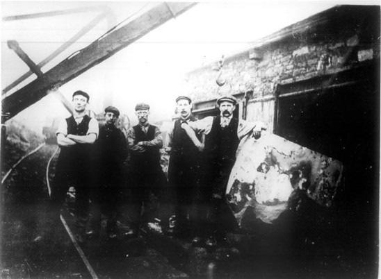
Although only small, this offers a very clear illustration of the style of working in the Rossendale quarries.
|
|
|
- Jocelin Floyd
- 5 years ago
- Views:
Transcription

1 You are here: The Journey > Selected Heritage sites > Fecit End Delf Fecit End Delf Although only small, this offers a very clear illustration of the style of working in the Rossendale quarries. Location: The quarry is positioned about 400m west of Turn village on the end of Fecit Hill. Lying at about 350m above sea level, it can be accessed from a public footpath leading from the Rossendale Way. Historical Summary Geology: The workings are in the Upper Haslingden Flagstones. Products: Included road setts, kerb stones and flagstones. Quarry Firms: The quarry was in operation before So far we know of only 1 quary owner: Woodvine who worker the quarry around 1939 to Summary of Surviving Remains: The hillside quarry consists of outcrop quarrying with some open pit quarrying. In the south eastern corner of the quarry is an extraction pit which contains the remains of a collapsed crane.

2 The remains of a loading and processing area is located within the SE section of the quarry, consisting of a series of stacked dressed stone lintels and waste debris located on a probable loading platform. The stone banker benches used by the masons also survive. The spoil fingers and mounds are all clearly defined and have been colonised by moorland vegetation. An extensive area of quarry debris extends down the southerly slope of Fecit Hill and creates a prominent landscape feature, which can be observed from Rochdale Road (A680) and the Rossendale Way. In recent years a gun club has constructed a shooting gallery to the north-east of the processing site. You are here: The Journey > Selected Heritage sites > Heald Slate Quarries Heald Slate Quarries The main block of this quarry extends between SD and SD They lie close to the series of springs that are the source of the River Irwell, north of Bacup. The quarries are on the south-west edge of Heald Moor at a substantial distance from Deerplay Hill, and it would seem likely that they may be more correctly identified with the Heald Slate Quarries ( Davies : Deerplay entry). Deerplay Hill Quarries are situated approximately one kilometer to the west at SD The area was formally part of the medieval pasture land of Deerplay, adjacent to the

3 Bacup vaccary (see Tupling 1927, 20; VCH Lancs xi, 437n6), which was gradually enclosed during the post medieval period. No tithe survey was compiled for this area. Historical Summary: Working Life: there may have been stone quarrying in the area from the sixteenth or seventeenth centuries. The quarries were near their final size by the 1840s and disused by Quarry firms: Lords, and Blezzards owned Heald Slate quarries (Davies Deerplay Hill entry). Geology: Dyneley Knoll Flags. Methods: hillside outcroppings. Transport: horse and cart. Products: included roofing slate (to all parts of country) Davies Deerplay Hill entry).
 which is shown situated somewhere north of the graffe dytche (presumably Greave Clough).")
4 Events: 1601 Plan of Horlaw Head and Cliviger Common shows a series of stone quarries running from Deerplay Hill to Tooter Hill. One of these quarries may relate specifically to this site, a stone of the salatte pites (ie Slate Pit) which is shown situated somewhere north of the graffe dytche (presumably Greave Clough) OS 1st edn 6 (sheet 72) shows series of quarries labeled from north to south: Sandstone Quarry (Flags), Sandstone Quarry (Flags and Ashlar) Heald slate quarries (and Deerplay Hill quarries) in full production (Davies ) 1893 OS 25 map shows Old Quarries and Old quarry OS 25 map shows as 1893 map OS 6 geology map (sheet 72NE) shows quarry in Dyneley Knoll Flags of Lower Coal Measures, NW group labeled Flags with Sandy Shale Partings ; SE group, Micaceous Brown Flagstone OS map shows as 1909 map. Summary of surviving remains: The group of quarries are hillside outcroppings with a series of small working faces, broadly lying on the north side with the spoil tipped down the slope to the south. The spoil heaps are extensive and relatively undisturbed. The main approach to the quarries is from Heald Lane with a trackway running along the south side of the area. Identified quarry features include the foundations of several structures (quarrymen s shelters or storage, earthwork platforms and possibly processing areas, and a leat. The foundations of Top cottages, seen on the OS maps from to 1928, were also located here.
5 You are here: The Journey > Selected Heritage sites > Cloughfold scrubbing mill Cloughfold scrubbing mill Cloughfold Scrubbing Mill is located at NGR: SD and is positioned on the junction of a series of mineral tramways. The site can be accessed from a public footpath from Cloughfold, which follows the line of a tramway incline. The Cloughfold Mill is an exceptional archaelogical site and one of the most important industrial processing remains in Rossendale. Historical Summary Working life: Post 1849 (OS 6 1st edn map)/pre (OS 6 2nd edn map). Its construction may be contemporary with construction of the tramway system in Probably disused by 1920 when the track of the Cloughfold Ding tramway lifted (Groundwork Rossendale n.d.) Quarry firms: Butterworth & Brooks. Brooks & Brooks. Methods: Steam-powered machinery. Hand dressed stone. Transport: The tramway moved material from the quarry and scrubbing mill to the main railway at Clough Fold. A system of tramways also connected the mill with Cragg, Ding, Great Height, Hurdles and Brow Edge quarries. Products: Building stone, stone flags. Events: Thomas Greenwood had his leg broken below the knee on the quarry incline. He was riding on the third wagon of three when the front wagons became loose and rolled back and struck him breaking his leg A young man in charge of wagons bringing stone from the quarries was killed when the brakes and sprags failed and the wagons went out of his control Robert Dawson, 55, was killed while oiling rollers on the tramway wire haul rope. He was struck by the full wagons coming down the incline and carried 20 yards before the wagons stopped. Both legs and his right arm were broken and his back and head were cut and bruised. He died later of his injuries James Rawlins and Samuel Payne were injured when a copper chain attached to three laden wagons broke. The two men, along with two others who were uninjured had been riding the wagons and jumped off. The rock flew from the wagon and injured Edward Croasdale who would need amputation of one or two limbs Patrick Callaghan, farm labourer, suffered a crushed right arm as he tried to jump onto empty wagons.
6 Two laden wagons were descending the incline when the rope broke and they ran down the slope until eventually coming to a standstill. Little damage was done Five anvils offered for sale from Whinberry Naze. One for double blasted bellows, tongs, top and bottom steel swages, swage blocks, vice, screwing tackle, quantity of iron and steel Goodshaw Church rambling club visited the mills. The stones are prepared by putting a layer of stone on a circular ring of iron with another set of stones on top and are fastened by iron bands. They are turned in opposite directions to polish them Three laden wagons left the track after the wire haul rope parted. The wagons dropped into the road leading to Victoria Buildings, two of the upright pillars by which the bridge over that road can be raised when required were snapped off, the sleepers on the bridge were broken. A stone smashed through a panel of the office door adjoining and a considerable amount of damage was done William Fields was loading flags onto a wagon when some of the flags fell breaking both bones in one leg. He was taken to Manchester Infirmary by train A fatal accident occurred to John Isaac Ashford, 22. When accompanying laden wagons with another man a stone fell under the wheels of a wagon tipping it, and the deceased, onto the road below. The wagon had fallen on his head and he died a short time later Martin Varley was going home along the tramway when a link broke on the wire haul rope. Portions of the link flew up and hit him on the leg causing a compound fracture References to the sale of cranes, wagons and other appliances for Brooks Cloughfold Quarries. Includes two locomotives and the railway they formerly run over. Tearing up the railway will remove one of the features on the further side of Cowpe Lowe. The track was laid about and runs from the top of the tramway at Cloughfold, along the breast of the hill around Foe Edge Farm to Cragg Quarry. One spur runs to Ding Quarry and then the quarries at Britannia. Over 5 miles long. Before the railway the stone was conveyed on horse drawn sledges over Rooley Moor and down to Rochdale and Heywood. The quarries were closed at the outbreak of war and very little work has occurred there since. The railroad is now being torn up and the buildings and quarry plant dismantled Demolition of a large wooden bridge on the east side of Cloughfold crossing. Bridge formerly used for carrying a tramway from Brooks & Brooks Quarry over the River Irwell to the Cloughfold railway sidings.

7 Summary of Surviving Remains This mill site contains a series of ruinous structures and features which are related to both the processing and movement of stone. The structures include a building which may have been used as a dwelling, a structure which appears to have acted as a polishing mill and boiler house, and a structure which probably housed three stone sawing machines. Both of the mill sites appear to have associated water channels, probably housing pipes, which supplied water to the mills from a reservoir located in the north-west area of the site. The remains of a possible engine shed and chimney are also located to the south-west of the polishing mill, whilst at the southern end of the site are the degraded remains of a winding house. Surrounding the mills are a series of visible tramways and the piers for trestle bridges, loading and processing platforms, a number of crane platforms and bases, deposits of boiler slag, ash, and exposed dumps of processing waste. An arcing section of processing waste on the eastern side of the site is particularly well defined and appears to represent waste material from the saw mill.
8
Editorial. Victoria. Absolute Shocker. Reported incidents. Visit us on the web. Traffic Management Focus
 Absolute Shocker Editorial Traffic Management Focus Barry Dunn, WorkSafe s Construction Program Strategy Manager writes about the traffic management focus, which commences on the 15 August 2016. The Safe
Prior's Moor, Billingsley
 Prior's Moor, Billingsley David Poyner & Robert Evans (SCMC Journal No.6) Introduction Priors Moor is located in Billingsley where two small brooks (now known as Ray's and Scott's Brooks) unite to form
4. Bronze Age Ballybrowney, County Cork Eamonn Cotter
 4. Bronze Age Ballybrowney, County Cork Eamonn Cotter Illus. 1 Location map of the excavated features at Ballybrowney Lower (Archaeological Consultancy Services Ltd, based on the Ordnance Survey Ireland
Open Report on behalf of Richard Wills Executive Director for Communities. Planning and Regulation Committee. County Matter Application - S38/0590/13
 Agenda Item 5.10 Report Reference: 5.10 Regulatory and Other Committee Open Report on behalf of Richard Wills Executive Director for Communities Report to: Planning and Regulation Committee Date: 10 June
MAN ROASTED TO DEATH
 Newspaper article, Indianapolis, Indiana; August 7, 1897: MAN ROASTED TO DEATH ENGINEER JAMMED AGAINST A HOT BOILER IN A WRECK. Collision Between a Pennsylvania Fast Train and a Monon Engine Other Trainmen
Brenig Archaeology Trail
 Walk Information: Maps: OS Explorer 264 Distance: 2.5 miles / 4 kilometres Duration: Allow 2.5 hours for the circular walk Difficulty: easy. Well-marked trail over fields. Start and finish: SH 98325741
Summary. Kvaerner s Investigation Report. Fatal accident at Stord, Norway 7 March / 5
 Summary Kvaerner s Investigation Report Fatal accident at Stord, Norway 7 March 2015 1 / 5 Summary of Kvaerner s internal Investigation Report of the fatal accident at Stord 7 March 2015 Background Kvaerner
Archaeological Watching Brief at the Brick Stables and Wagon Lodge, Abbey Barns, Abbey Road, Faversham, Kent September 2010
 Archaeological Watching Brief at the Brick Stables and Wagon Lodge, Abbey Barns, Abbey Road, Faversham, Kent September 2010 SWAT. Archaeology Swale and Thames Archaeological Survey Company School Farm
Mining & Railways in Weardale. by Barry Kindleysides
 Mining & Railways in Weardale by Barry Kindleysides In 1154 King Stephen granted all the mineral rights in Weardale to his nephew Hugh Bishop of Durham. From then on a succession of Bishops owned these
Tacklers Trail. Walk No miles. (A walk with a couple of short steep slopes and some rough moorland paths)
") Tacklers Trail Walk No.3 9.5 miles (A walk with a couple of short steep slopes and some rough moorland paths) WALK 3 TACKLERS TRAIL 9.5 miles (moderate wi 1. Sunnyhurst Visitor Centre The Warpers Trail
Tacklers Trail Walk No.3 9.5 miles (A walk with a couple of short steep slopes and some rough moorland paths) WALK 3 TACKLERS TRAIL 9.5 miles (moderate wi 1. Sunnyhurst Visitor Centre The Warpers Trail
Rochdale Road & Thorn
 Copyright bacuptimes.co.uk Rochdale Road & Thorn Rochdale Road was not always as we know it today if a traveller wanted to get to Rochdale from Bacup his journey would begin in the centre of Bacup whereupon
The Holes Creek Bridge Replacement By Bradley McClelland
 The Holes Creek Bridge Replacement By Bradley McClelland Each time there is a heavy rainstorm, the folks along Sheffield Road in the Dayton, Ohio suburb of West Carrollton have cause to be concerned. Holes
Looking north from the SW shieling site with Lub na Luachrach in the foreground
 Looking north from the SW shieling site with Lub na Luachrach in the foreground Upper Gleann Goibhre - Shieling sites Two shieling sites in the upper reaches of the Allt Goibhre were visited and recorded
Gorse Stacks, Bus Interchange Excavations Interim Note-01
 Gorse Stacks, Bus Interchange Excavations 2015 Prepared for: Cheshire West & Chester Council Interim Note-01 1 Introduction & Summary Background Since c. 2000 investigations associated with redevelopment
Control Description Sheet 1
 Control Description Sheet 1 Headings I0A Example M20 M21 M35 1 8.8km 250m Event Title Classes (optional) Course Code; Course length, Height climb Start location as if it was a control. First Control Description
HARDMOORS 55 RACE ROUTE 2018 HELMSLEY - GUISBOROUGH
 HARDMOORS 55 RACE ROUTE 2018 HELMSLEY - GUISBOROUGH HELMSLEY - CHECKPOINT 1 (WHITE HORSE) 1. Leave RACE START, continue ahead on road (Baxtons Sprunt) At crossroads turn right down Canons Garth eventualy
Assembly instructions for Eurotramp trampolines Series: Ultimate, Grand Master Exclusiv, Grand Master, Master
 Assembly instructions for Eurotramp trampolines Series: Ultimate, Grand Master Exclusiv, Grand Master, Master 1. Assembly instructions 2. Attaching the plastic coated steel cables on the Ultimate frame
An archaeological watching brief on land adjacent to 50 Rosebery Avenue, Colchester, Essex May/June 2003
 An archaeological watching brief on land adjacent to 50 Rosebery Avenue, Colchester, Essex May/June 2003 report prepared by C Crossan on behalf of Highfield Homes Ltd NGR: TM 0035 2500 CAT project ref.:
Nova. Rollator OWNERS HANDBOOK. Product Code: WA01063
 Nova Rollator OWNERS HANDBOOK Product Code: WA01063 Your Tuni Nova Rollator Product Features 1. Easily removable bag attached. 2. Easy to fold, easy to store and transport. 3. Easy to adjust handle to
North Wales Miners Association Trust Ltd Wrexham South Mine Trail
 North Wales Miners Association Trust Ltd Wrexham South Mine Trail An 18 mile circular trail by car or bike, passing features relating to the local coal, lead and iron industries. Note that some of the
Day of Mourning. April 28, 2017
 Day of Mourning April 28, 2017 Day of Mourning April 28, 2017 Day of Mourning is a day intended to recognize those who lost their lives as a result of a work-related incident or occupational diseases.
Gors Lydan barrows and medieval huts
 Walk Information: Maps: OS Explorer 214 Distance: 5.5 miles / 9 kilometres Duration: 4.5 to 5 hours Difficulty: Easy. Good paths and no steep gradients Start and finish: SO 11977545 Walk summary The walk
ISOM & ISSOM forbidden symbol comparison
 & forbidden symbol comparison Forbidden symbols and their relatives Symbol 2000 (Long, Middle) 2007 (Sprint) 201 Impassable cliff An impassable cliff, quarry or earth bank (see 106) is shown with a 0.35
Cragg Vale to Todmorden
 Cragg Vale to Todmorden Map Co-Ordinates : SE 002232 The Te Duem Stone near Stoodley Pike symbolises a long tradition of wayfaring. Crossing the the Pennine Way, the route drops down towards Lumbutts and
Product instruction manual Ream Cutting Systems RE3943, RE3946, RE3947, RE3971, RE3952E
 Product instruction manual Ream Cutting Systems RE3943, RE3946, RE3947, RE3971, RE3952E The Trimfast Ream Cutters are reliable, high performance cutters that will give you the results you need quickly
In 2014 excavations at Gournia took place in the area of the palace, on the acropolis, and along the northern edge of the town (Fig. 1).
.") Gournia: 2014 Excavation In 2014 excavations at Gournia took place in the area of the palace, on the acropolis, and along the northern edge of the town (Fig. 1). In Room 18 of the palace, Room A, lined
Gournia: 2014 Excavation In 2014 excavations at Gournia took place in the area of the palace, on the acropolis, and along the northern edge of the town (Fig. 1). In Room 18 of the palace, Room A, lined
PHOTOGRAPHY LOCATIONS
 PHOTOGRAPHY LOCATIONS The East Lancashire Railway welcomes people to come and take advantage of some of the fantastic and unique photo opportunities our railway provides. The railway offers great photo
Walk 1: Highfield, Lob Wood and The River Wharfe
 Walk 1: Highfield, Lob Wood and The River Wharfe Start: The Hen Pen Garden, Main Street, Addingham LS29 0NS, SE 077 498. Alternative Start: Near Bolton Bridge SE 071 525 (see page 6). Full walk: 4.5 miles
Stone Mills. Rob Arkell: Trowbridge Archaeology Group
 Stone Mills Rob Arkell: Trowbridge Archaeology Group Stone Mills Main Building 2013 A mill linked to Trowbridge Castle stood on the site of Stone Mills as far back as 1331 and the site was acquired by
U3A WALK Harby Hose. Route Summary. Route Overview. Description. Waypoints. Harby. Stuart Galloway
 U3A WALK Harby Hose Stuart Galloway Route Summary A circular walk taking in Harby, Hose and the Grantham Canal. Route Overview Category: Walking Length: 7.310 km / 4.57 mi Parking: Village Hall School
dry stone walling trail A short walk to learn about dry stone walls in the Colne Valley
 The Upper Colne Valley dry stone walling trail A short walk to learn about dry stone walls in the Colne Valley The Upper Colne Valley dry stone walling trail Marsden Start Location: Marsden Railway Station,
are greasable that the units *Positive indexing for raising roll down the track on and
 We at the Thomas family have deep roots in the Maine tradition of craftsmanship and innovation. Dale Thomas began working with steel in 1959 and for almost five decades gained extensive experience in steel
Beamers Trail. Walk No.1. 6 miles. (easy with some moderate ascents and descents)
") Beamers Trail Walk No.1 6 miles (easy with some moderate ascents and descents) 1 BEAMERS TRAIL 6 miles (easy with som WALK The Warpers Trail forms part of the long distance Witton Weavers Way. This is
Beamers Trail Walk No.1 6 miles (easy with some moderate ascents and descents) 1 BEAMERS TRAIL 6 miles (easy with som WALK The Warpers Trail forms part of the long distance Witton Weavers Way. This is
Excavations in a Medieval Market Town: Mountsorrel, Leicestershire,
 Excavations in a Medieval Market Town: Mountsorrel, Leicestershire, by John Lucas Mountsorrel is situated 12 kms north of Leicester and forms a linear settlement straddling the A6, Leicester to Derby road.
Chiselbury Camp hillfort
 Chiselbury Camp hillfort Reasons for Designation Large univallate hillforts are defined as fortified enclosures of varying shape, ranging in size between 1ha and 10ha, located on hilltops and surrounded
Axe and Saw Permit: Safe Use of Axes
 Page 1 of 7 Objective: The objective of this workshop guide is for the Scout Leader and/or Scout youth to be able to describe and demonstrate safe use of the Axe. Axe or Hatchet: What s the difference?
NWAC Blog. Cornices - don't walk the line! Written by Robert Hahn on March 14, Last update on May 15, 2017.
 NWAC Blog Cornices - don't walk the line! Written by Robert Hahn on March 14, 2017. Last update on May 15, 2017. Human-triggered cornice fall avalanche from March 10th, 2017. The crown release exposed
General Summer and Winter Views
 ENVIRONMENTAL INFORMATION REPORT VOLUME 4 APPENDIX 11. 2 General Summer and Winter Views Table of Contents Section APPENDIX 11.2 Page 1 General Views... 1-1 Tansy Lane, Portishead... 1-2 Galingale Way,
Appendices A (Our ambition for nature (A3 plan) and further information)
 and further information)") Appendices A (Our ambition for nature (A3 plan) and further information) Penny Hill Farm Nature Conservation vision Key: Tenancy boundary Meadow restoration & Mowing/meadow F33 Mowing/meadow Progress towards
Appendices A (Our ambition for nature (A3 plan) and further information) Penny Hill Farm Nature Conservation vision Key: Tenancy boundary Meadow restoration & Mowing/meadow F33 Mowing/meadow Progress towards
European Maritime Safety Agency MARINE CASUALTIES AND INCIDENTS
 MARINE CASUALTIES AND INCIDENTS SUMMARY OVERVIEW 2011-2015 TAKING A BROADER VIEW IN ACCIDENT INVESTIGATION It is with great pleasure that I introduce this new publication based on EMSA s activities in
A STEAM LOCOMOTIVE CREW MEMBER by Charles H. Bogart
 A STEAM LOCOMOTIVE CREW MEMBER by Charles H. Bogart When I heard in May 2017 that Gramling Locomotive Works would bring their 0-4-0T 1928 Vulcan Iron Works steam locomotive to Bluegrass Railroad Museum
Newbold Hall, Rochdale. An Archaeological Excavation
 School of the Built Environment CUBE Building, University of Salford 113-115 Portland Street Manchester M1 6DW Tel: 0161 295 3818 Email: m.d.nevelle@salford.ac.uk Web: www.cfaa.co.uk Newbold Hall, Rochdale.
PD Series Ram-Air Reserve Parachute Owner s Manual Addendum. PRO Packing Instructions
 PD Series Ram-Air Reserve Parachute Owner s Manual Addendum PRO Packing Instructions This document is a supplement to the PD Series Ram-Air Reserve Parachute Owner s Manual, Third Edition. It contains
Archaeological Investigations Project Yorkshire & Humberside Region NORTH YORKSHIRE 2/1113 (C.36.J002) SD
 SD") NORTH YORKSHIRE Craven 2/1113 (C.36.J002) SD 93607800 CRAY BECK, BUCKDEN, UPPER WHARFEDALE Cray Beck, The Archaeological Investigation of a Stone Feature Archetype Wensleydale : ArcheType Archaeological
NORTH YORKSHIRE Craven 2/1113 (C.36.J002) SD 93607800 CRAY BECK, BUCKDEN, UPPER WHARFEDALE Cray Beck, The Archaeological Investigation of a Stone Feature Archetype Wensleydale : ArcheType Archaeological
INLAND STEEL COMPANY, INDIANA HARBOR WORKS PHOTOGRAPHS,
 Collection # P 0711 INLAND STEEL COMPANY, INDIANA HARBOR WORKS PHOTOGRAPHS, 1926 Collection Information 1 Historical Sketch 2 Scope and Content Note 3 Contents 4 Processed by Dalton Gackle July 2018 Manuscript
Report on an archaeological watching brief at Thomas Lord Audley School, Monkwick, Colchester
 Report on an archaeological watching brief at Thomas Lord Audley School, Monkwick, Colchester July 2000 for WS Atkins Property Services Colchester Archaeological Trust 12 Lexden Road, Colchester, Essex
WORK RELATED DEATHS NEW SOUTH WALES - JULY 2009 TO DECEMBER ALL INDUSTRIES Date First Name Surname M/F Age Details Mechanism Industry No.
 NEW SOUTH WALES - JULY 2009 TO DECEMBER 2009 - ALL INDUSTRIES 22-Jul-09 Unknown M 60 Fall from height A plumber/drainer worker was negotiating a descent from a ladder when he slipped and fell approx. 2.8
Swing-out Van Key Bench
 Swing-out Van Key Bench Eugene E Hansen Feb 2006 In this article we will describe how we made a swing-out bench with key machine mounts and key storage cabinets on a Ford Van F350 (one ton). To start with
Redesigning The Waterfront
 San Francisco Maritime National Park Service U.S. Department of the Interior National Historical Park California Redesigning The Waterfront A Self-Guided Walking Tour Then & Black Point Cove, ca. 1910.
23) Nantlle vale (Dyffryn Nantlle)
 Nantlle vale (Dyffryn Nantlle)") 23) Nantlle vale (Dyffryn Nantlle) Nantlle vale is one of the three great slate quarrying areas of North Wales, the others being the Bethesda - Llanberis area in the north, and that of Ffestiniog further
23) Nantlle vale (Dyffryn Nantlle) Nantlle vale is one of the three great slate quarrying areas of North Wales, the others being the Bethesda - Llanberis area in the north, and that of Ffestiniog further
Places in Brent. Stonebridge. Grange Museum of Community History and Brent Archive
 Places in Brent Stonebridge Grange Museum of Community History and Brent Archive Stonebridge is situated in southern Brent, on the Harrow Road between Harlesden and Wembley. The 17 th and 18 th centuries
Sand and Aggregates
 www.marshalls.co.uk Sand and Aggregates HOWLEY PARK QUARRY WF12 7JJ STAINTON QUARRY S66 7RH SCOUT MOOR QUARRY BL0 0RQ CLEAN MATERIALS Gabion stone For baskets 150-75mm Clean stone for general purpose 75-40mm
A Visit to Cloud Cap Inn
 October 2018 A Visit to Cloud Cap Inn Webfooters Post Card Club PO Box 17240 Portland OR 97217-0240 www.thewebfooters.com A Visit to Cloud Cap Inn Above the Clouds Mountain climbers visit Cloud Cap Inn,
BURGHCLERE PARISH RIGHTS OF WAY
 BURGHCLERE PARISH RIGHTS OF WAY Full descriptions compiled by Neill & Miggie Bruce All photos Miggie Bruce FP23 on Ridgemoor, looking south, with FP22 crossing by the bush FP1. From C183 Aldern Bridge
Leaden Boot Challenge ROUTE INSTRUCTIONS
 Leaden Boot Challenge ROUTE INSTRUCTIONS Section 1 Alstonefield to Ilam From the village hall car park turn R then L and pass through the village keeping to the R to enter Church Street. Pass the Church
Skills Session: Woods Tools Knife, Camp Saw, and Axe
 Skills Session: Woods Tools Knife, Camp Saw, and Axe Time Frame: 1 Hour Materials: Resources: Goals: There should be one each of the following items for every two participants: Knife Axe Camp Saw Sharpening
DETROIT, TOLEDO, AND IRONTON RAILROAD PHOTOGRAPHS SUBSERIES, Accession 548
 Finding Aid for DETROIT, TOLEDO, AND IRONTON RAILROAD PHOTOGRAPHS SUBSERIES, 1922-1923 Finding Aid Published: June 2011 20900 Oakwood Boulevard Dearborn, MI 48124-5029 USA research.center@thehenryford.org
Invergordon in World War II
 Invergordon in World War II Sites and Features Listing The Invergordon in World War II project run by Invergordon Museum investigated wartime activity in Invergordon during the Second World War. Over 900
The Bridestone Rocks from Lydgate
 Print this page Back to results The Bridestone Rocks from Lydgate Ancient tracks and gritstone outcrops, with terrific views of the steepsided Cliviger Valley. Distance 5 miles (8km) Minimum time 2hrs
Cars and Engine Badly Damaged in Collision Late Friday Afternoon
 BROKEN CLUTCH ON A SWITCH ROD THE CAUSE OF WRECK Investigation Discloses Why Hocking Valley Train Left Track at Winchester SIDE-SWIPPED ANOTHER TRAIN Nine Passengers and Carman Are Injured, But None of
Solar Power Shade INSTRUCTION MANUAL
 INSTRUCTION MANUAL 20 June 2006, Revision Initial Release 26 September 2006, version 2 Powerfilm, Inc. 2337 230th Street Ames, IA 50014 (515) 292-7606 Web Site: www.powerfilmsolar.com Table of Contents
Lake Wissota Access Locations within the LaFayette Township. By Chad Martin
 Lake Wissota Access Locations within the LaFayette Township By Chad Martin Anson/ Wissota Access Point # 1 Road: 195 th St. Associated Fire Numbers: 13294 Defining Characteristics: Forested from road
DURANGO, COLORADO 2015
 DURANGO, COLORADO 2015 Durango, Colorado 2015 Su and I recently returned from one of the most memorable and exciting trips we've had in a long time. We went to Durango, in Colorado, and rode the old steam
Intrepid 2 Intrepid 3
 Intrepid 2 Intrepid 3 Model Nos. V 10 / V10-3 NAT GAS Model Nos. V12 / V12-3 L.P.G DECORATIVE COAL EFFECT GAS STOVE USER INSTRUCTIONS This appliance is only for use on Natural Gas (G20) at a supply pressure
DELTICS and other DIESELS Volume 1
 DELTICS and other DIESELS Volume 1 5 th January 1981: 1 a) 31184 arrives at Nuneaton on a Birmingham service at 1110hrs. b) As 85018 arrives on ECS, 31184 sets off. 2 At Nuneaton, 25125 is heard shunting
Section 13. Job Safety Analysis
 Section 13 Job Safety Analysis Table of Contents Operating an ATV... 001 Chainsaw Operations... 002 Operating Jack Hammer... 003 Planting IP s... 004 Planting Lathe/Hubs... 005 Working On Or Around Roadways...
The Disaster at The Crarae Quarries (Scotland)
") The Disaster at The Crarae Quarries (Scotland) In Scientific American Supplement, Vol. XXII, No. 569 November 27, 1886, pp. 9079 This article, which begins on the next page, is presented on the Stone Quarries
The Disaster at The Crarae Quarries (Scotland) In Scientific American Supplement, Vol. XXII, No. 569 November 27, 1886, pp. 9079 This article, which begins on the next page, is presented on the Stone Quarries
Picnic Units A picnic unit is a part of a picnic area
 Grab Bars Grab bars are usually provided in buildings to provide stability and allow a person to use his or her arms to assist in movement over short distances. The most common location for grab bars is
ESCONDIDO FIRE DEPT TRAINING MANUAL Section Truck Module Page 1 of 12 Salvage and Overhaul Operations Revised
 Truck Module Page 1 of 12 SALVAGE OPERATIONS One of the largest hindrances to effective salvage work is a lack of staffing. As stated earlier, salvage operations are most effective if initiated during
Energy from Waste and Recycling Facility Trident Park, Cardiff. Planning History. January 2010 SLR Ref: B
 Energy from Waste and Recycling Facility Trident Park, Cardiff Planning History January 2010 Ref: 402-0036-0306B Viridor Ltd. i 402/0036/00306B CONTENTS 1.0 INTRODUCTION... 1 2.0 GENERAL HISTORY... 3
/ Tool and Equipment Safety Tether System (T.E.S.T.S)
") 20 INSTRUCTIONS FOR USE AND PRODUCT GUIDE 799953 / 799955 Tool and Equipment Safety Tether System (T.E.S.T.S) Part # T353012 Rev 2 Reliance Industries LLC 2802 East X Street Deer Park, Texas 77536 281-930-800
20 INSTRUCTIONS FOR USE AND PRODUCT GUIDE 799953 / 799955 Tool and Equipment Safety Tether System (T.E.S.T.S) Part # T353012 Rev 2 Reliance Industries LLC 2802 East X Street Deer Park, Texas 77536 281-930-800
UW MEDICINE PATIENT EDUCATION. Breastfeeding is the healthiest way to feed your baby. It is also a skill that takes time and practice.
 Full of format problems, sorry! UW MEDICINE PATIENT EDUCATION This chapter has illustrations that need to be moved! Attaching Your Baby to Your Breast Laid-back, cross-cradle, football, and side-lying
A hidden heritage. A hidden heritage. The Incline and Winding House. To the Brendon Hills. By bus. By car. On foot
 How to to find find us us The Incline and Winding House To the Brendon Hills By bus For up to date information check the Travel Line website at www.travelinesw.com or the Exmoor National Park Getting around
Bridging Belmont. By ROGER AMSDEN, LACONIA DAILY SUN
 Bridging Belmont This covered bridge was bought for $1 in 2013 from Dover, and broken into three sections. One section was installed two years ago, and the second and third sections were combined for a
Skyline Drive Hogback Canon City
 Skyline Drive Hogback Canon City Direction to trailhead: From US 50, turn north onto 15th Street. At the traffic circle, continue north on 15th Street until it dead ends at Washington Street (about 1.5
Radnorshire Historic Settlements: Earthwork Survey
 THE CLWYD POWYS ARCHAEOLOGICAL TRUST I., ; I./ "oh';;: Radnorshire Historic Settlements: Earthwork Survey 1995-6 ;--- - ~.'l:1 ';, CPAT Report No 169 CPAT Report No 169 Radnorshire Historic Settlements:
Boddington Farm. Luddington Stratford-Upon-Avon Warwickshire
 Boddington Farm Luddington Stratford-Upon-Avon Warwickshire Boddington Farm LUDDINGTON STRATFORD-UPON-AVON WARWICKSHIRE CV37 9SD An attractive village farmhouse in need of renovation and courtyard development
USER MANUAL BMU WORKCAGE. CONFORM TO THE MACHINE DIRECTIVE 2006/42/EC and to EN1808 (1999)
") USER MANUAL BMU WORKCAGE CONFORM TO THE MACHINE DIRECTIVE 2006/42/EC and to EN1808 (1999) All persons operating this equipment must read and completely understand this manual. Any operation in violation
USER MANUAL BMU WORKCAGE CONFORM TO THE MACHINE DIRECTIVE 2006/42/EC and to EN1808 (1999) All persons operating this equipment must read and completely understand this manual. Any operation in violation
Alternative Designs Report Joshua s Jumper
 Alternative Designs Report Joshua s Jumper By Elyssa Polomski, Michael Ballintyn, and Tianyi Xu Team # 21 Client: Joshua Bouchard Client Contact: Sue and Ron Bouchard, soupanony@aol.com, (508) 823-6113
Axes. The information below will assist the Scout in obtaining their Forester badge.
 Axes The information below will assist the Scout in obtaining their Forester badge. Axes can come in different shapes and sizes, the two axes that are of most relevance to any Scout Troop will be the HANDAXE
General Metal Shop Safety
 Youth Explore Trades Skills General Metal Shop Safety Description The purpose of this activity is to introduce students to the metal shop environment while giving a brief description of tools, equipment,
Following the Worcester & Birmingham Canal Feeder in Kings Norton Visiting Lifford Reservoir & Wychall Reservoir. Lifford
 Worcester-Birmingham & Droitwich Canals Society SUMMER WALK Following the Worcester & Birmingham Canal Feeder in Kings Norton Visiting Lifford Reservoir & Wychall Reservoir Lifford Reservoir Wychall Reservoir
Stay Safe Thomas. with
 Stay Safe Thomas with Stay Safe Thomas with Based on The Railway Series by the Rev. W. Awdry First published in Great Britain 2018 by Dean, an imprint of Egmont UK Limited The Yellow Building, 1 Nicholas
Slot Couloir Accident, Snoqualmie Mt
 Body Page 1 Slot Couloir Accident, Snoqualmie Mt 4-27-14 Date and Time: estimated 12 pm, Sunday 4/27/14 Location: Slot Couloir, Snoqualmie Mt Number in Party: 2 backcountry skiers Number hurt: 1 backcountry
User Guide. 12ft (3.66m) ZorbPOD. with 15.5ft (4.72m) wide enclosure. Got a Problem building your trampoline? Call us on and we can help
 ZorbPOD. with 15.5ft (4.72m) wide enclosure. Got a Problem building your trampoline? Call us on and we can help") User Guide 12ft (3.66m) ZorbPOD with 15.5ft (4.72m) wide enclosure Got a Problem building your trampoline? Call us on 0344 800 4060 and we can help Patent no: DE602006006495D1, EP1721640B1 and US7628731
User Guide 12ft (3.66m) ZorbPOD with 15.5ft (4.72m) wide enclosure Got a Problem building your trampoline? Call us on 0344 800 4060 and we can help Patent no: DE602006006495D1, EP1721640B1 and US7628731
Woodland Walk If you enjoyed this walk there are two others available in the same area.
 The Woodland Walk 11-12 kilometres (7-8 miles) 4-5 hours Terrain: some easy hills Can be slippery when wet 5 stiles Unsuitable for a pushchair/wheelchair Uses OS map 197 Parking: Pulborough Station and
Limestone terraces (in the distance) and woodland on hills in the Upper Wharfedale valley
 and woodland on hills in the Upper Wharfedale valley") GRASSINGTON North Yorkshire from www.discoverbutterflies.com the website for the book Discover Butterflies in Britain D E Newland 2009 Limestone terraces (in the distance) and woodland on hills in the
GRASSINGTON North Yorkshire from www.discoverbutterflies.com the website for the book Discover Butterflies in Britain D E Newland 2009 Limestone terraces (in the distance) and woodland on hills in the
Reservoir Tin workings
 The workings are quite over-grown and covered in moss, suggesting that they date to the earliest period of mining. This is supported by the fact that their head race was cut off by the reservoir (D49/47)
West Wirral (Dee Estuary)
") View of Hilbre Island from West Kirby with walkers at low tide. West Wirral (Dee Estuary) West Kirby is the start of the 12 mile long Wirral Way, the backbone of Wirral Country Park, the old Hooton to
View of Hilbre Island from West Kirby with walkers at low tide. West Wirral (Dee Estuary) West Kirby is the start of the 12 mile long Wirral Way, the backbone of Wirral Country Park, the old Hooton to
Section 1: Vocabulary. Be able to determine if the word in bold is used correctly in a sentence.
 Section 1: Vocabulary. Be able to determine if the word in bold is used correctly in a sentence. Hardships: difficult conditions or situations that cause discomfort and/or suffering Pioneers: the people
DEFENCE AREA 48 CANEWDON
 DEFENCE AREA 48 CANEWDON 1. Area details: Canewdon is 8 miles N of Southend-on-Sea, 1 mile S of the River Crouch. County: Essex. Parish: Canewdon. NGR: centre of area, TQ 905945. 1.1 Area Description:
OPERATOR INSTRUCTION MANUAL INCLUDING REPAIR PARTS FOR MODULAR GENERAL PURPOSE TENT SYSTEM (MGPTS) TYPE I
 TYPE I") OPERATOR INSTRUCTION MANUAL INCLUDING REPAIR PARTS FOR MODULAR GENERAL PURPOSE TENT SYSTEM (MGPTS) TYPE I Johnson Outdoors Gear, Inc. Eureka! branded tent products 625 Conklin Road Binghamton, NY 13903
OPERATOR INSTRUCTION MANUAL INCLUDING REPAIR PARTS FOR MODULAR GENERAL PURPOSE TENT SYSTEM (MGPTS) TYPE I Johnson Outdoors Gear, Inc. Eureka! branded tent products 625 Conklin Road Binghamton, NY 13903
Land off Birdie Way, Rush Green, Hertford, Hertfordshire
 Land off Birdie Way, Rush Green, Hertford, Hertfordshire An Archaeological Evaluation for Bride Hall Development Limited by Sarah Coles Thames Valley Archaeological Services Site Code RGH00/ 01 January
Leaden Boot Challenge 2016 ROUTE INSTRUCTIONS
 Leaden Boot Challenge 2016 ROUTE INSTRUCTIONS Section 1 Alstonefield to Ilam (CP2) From the village hall car park turn R then L and pass through the village keeping to the R to enter Church Street. Pass
User s Manual Trampoline 8
 User s Manual Trampoline 8 Model! WARNING Read all precautions and instructions in this manual before using this equipment. Save this manual for future reference. Maximum user weight 17 lbs. ASSEMBLY IMPORTANT
Beautiful Walks from the Blue Ball Inn
 Walk No. 5 RIVER VALLEYS AND MOOR Countisbury, Watersmeet, Hillsford Bridge, Cheriton, Shilstone Hill, Rockford and Chiselcombe. 8.5 MILES APPROX. Walking time four and a half hours approx. OS 1;25,000
Claro Community Archaeology Group
 Site Record Form Item Number Claro Community Archaeology Group 60940161 Date Initials Inspected Access Visibility NGR Centre 434851 458431 NGR Linear Item Description HOUSE Site Data Roundell's Manor History
Energy is transferred when it moves from one place to another, as
 55 Roller Coaster Energy R O L E P L A Y Energy is transferred when it moves from one place to another, as in the last activity when the energy from the rod was transferred to the nail. Energy is transformed
Chester's City Walls. Guide Location: England» Chester # of Attractions: 8 Tour Duration: 1 hour(s) Travel Distance: 2.3 km.
 Travel Distance: 2.3 km.") Copyright by GPSmyCity.com - Page 1 - Chester's City Walls Chester is the only city in Great Britain that maintained the full circuit of its ancient defensive walls. The main access through the walls is
Copyright by GPSmyCity.com - Page 1 - Chester's City Walls Chester is the only city in Great Britain that maintained the full circuit of its ancient defensive walls. The main access through the walls is