Survey and Excavation at el-multaga, a Resettlement Area related to the Construction of the Merowe Dam: preliminary results
|
|
|
- Winifred Stokes
- 5 years ago
- Views:
Transcription

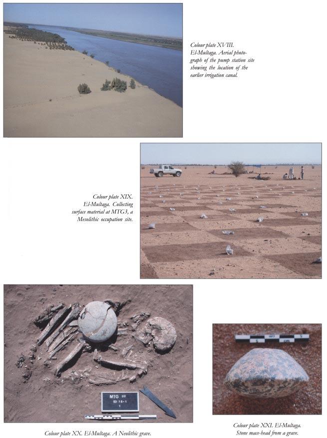
1 Survey and Excavation at el-multaga, a Resettlement Area related to the Construction of the Merowe Dam: preliminary results Francis Geus and Yves Lecointe Introduction The idea of building a dam on the Fourth Cataract of the Nile was first suggested in 1943 then revived in about 1980, but it is only at the end of the last century that it finally became a reality under the Ministry for Energy and Mining Resources of the Sudan. The project, which began in 2001 should be completed by It will result in the flooding of the Nile valley between the island of Mirowy, on the Fourth Cataract, and Mograt Island, near el-kab (see Salah Mohamed Ahmed, above). Meanwhile, the population currently residing here will be resettled in four different areas where the Sudan Government will develop agricultural schemes and build new villages: Goshabi-Abu Dom, the lower valley of Wadi Muqaddam, an area located north of Abu Hamed and the lower valley of Wadi Mukabrab. The task of the French Unit of the National Corporation for Antiquities and Museums will be to carry out comprehensive surveys and excavations in those areas prior to the implementation of the projects. So far, the area located in Goshabi-Abu Dom is the only one that has been affected by the project (Figure 1). It has been named el-multaga - the crossroads - because the new Bayuda road, which links Omdurman to Abu Dom, divides there into two branches, one going upriver towards the Fourth Cataract and the other downriver towards Dongola. The Figure 1. Location of el-multaga. 33 project, involving the building of three new villages, a pumping station and a network of canals, is now completed (Plate 1, Colour plate VI). Since a few weeks ago the villages were inhabited and the scheme will certainly be in operation soon. During five months, from November 2001 to April 2002, the French Unit, assisted by inspectors of NCAM, made a thorough investigation of the area, where 147 archaeological localities were recorded, including Neolithic burial sites that were only identified at the end of the season. Owing to a significant delay in the implementation of the scheme and thanks to the financial support of the French Ministry of Foreign Affairs, a second campaign, mainly devoted to the excavation of the Neolithic burial sites, could be carried out in November-December Plate 1. Bulldozers at work in the scheme. The scheme covers an area about 5.5km wide and 15km long and, except at the pumping station, it lies at a distance of about 2km from the river (Figure 2). Eastward, the area is covered by small dunes of aeolian sand surrounded by deflated areas, while in the centre and westward it looks like a flat sandy plain with scattered low gravel mounds. Salam bushes are present almost everywhere. Former research was limited to survey and excavations carried out between ed-debba and Korti from November 1966 to January 1967 by members of the Combined Prehistoric Expedition under the leadership of J. L. Shiner (Shiner et al. 1971). They published few maps, all rather imprecise, which show 32 localities apparently located inside the scheme area. Unfortunately, since GPS was not available at that time, no sites were given co-ordinates and consequently, in great part because of continuous sand movement in the area, we failed to re-locate them. The survey As we had to survey the whole area, we prepared a map based on the 1:250,000 Survey Department sheets and on a sketch map of the project provided by the Ministry of Energy and Mining, to which we added a detailed GPS recording of the
2 Figure 2. Distribution of Prehistoric sites. contour of the scheme and the layout of the canals. In accordance with Fritz Hinkel s AMS system (Hinkel 1977), we divided the area into 3 squares which, in turn, were divided into 1 squares (nine units in each 3 square, numbered 1 to 9 from north west to south east) and subdivided into 30 squares (four units in each 1 square, labelled NW, NE, SW and SE). The side of a 1 square is about 300m long and the side of a 30 square about 150m. Once in the field, using the grid system of our map, we located with a GPS several 30 squares, marking out their sides with survey markers placed at a distance of 10. Then two different teams covered by car the marked squares and examined on foot all places displaying features distinct from clean aeolian sand. Any locality bearing evidence of ancient human activity was then recorded and classified with its GPS co-ordinates and the number of its 30 square. Whenever appropriate, the recording was completed by a random collection of archaeological material. The survey led to the identification of 147 sites (Table 1) including remains of single occupation (119) and mixed occupation (28) pertaining to Palaeolithic (23), Early Ceramic (105), Christian (34) and Late (13) horizons. Except for MTG 1, a settlement located near the river at the pumping station site, which produced only disturbed surface material (infra), Christian and late remains were restricted to a few pottery sherds that did not indicate significant activity. As a consequence, the main contribution of our work pertains to prehistory. MTG 1, a Christian site Our first involvement was the excavation of MTG 1, a medieval site located on the bank of the river in the area where the pumping station was soon to be built. The site had already been scraped some years before during the construction of an irrigation canal of a much smaller size (Colour plate XVIII). A 10 by 10m square, located west of that 34
3 Table 1. Sites recorded during the survey. Number of localities Single occupation Mixed occupation Palaeolithic Early Ceramic Medieval (Christian) Late canal, was excavated to a depth of 400mm in order to evaluate what actually remained of the archaeological sediments and whether structures were to be expected. It quickly became obvious that the archaeological material, which was plentiful on the surface, was much rarer in the underlying layer and non-existent below 300mm, where the subsoil was pure aeolian sand. Since all available information indicated that the archaeological remains were mostly surface material lying on a thick sand formation, we closed the work at that stage. The material collected consisted of pottery sherds, lithics, beads, ostrich eggshells, animal bones, red bricks, white plaster and human bones indicating the presence of both a settlement and a cemetery. The pottery included a wide variety of painted, incised and stamped wares. Fragments of qawadis may indicate the use of saqia. The beads, which were particularly numerous, are most of annular or discoid shape and made of ostrich eggshell. The Palaeolithic occupation The Palaeolithic remains are particularly numerous in the south-eastern part of the scheme (Figure 2), in an area where Shiner s team recorded a site that was numbered 91 and classified with two others as a flake assemblage with Levallois technique (Shiner et al. 1971). Those remains are mostly situated in square NE-36-I/6-J, where they occupy a 1km broad east-west strip of land that borders a large sandy plain over 2km. The surface displays numerous flakes and tools, mostly made of wadi chert, of which unworked blocks are scattered on the surface. On his way to Sai Island, Philip Van Peer made a short inspection of those sites and identified them as Middle Palaeolithic workshops where local chert was processed for manufacturing tools. In one of the localities, a small sounding showed that the lithic material, which was quite eroded on the surface, occurred also in an underlying deposit of Nile gravel, where it was remarkably fresh. He also described the associated industry as similar to the Middle Palaeolithic assemblages described by Shiner s team (supra) as flake assemblage with Levallois technique. He therefore concluded that those sites are of great archaeological interest; hence our decision to investigate them in more detail during the second season. That further investigation was carried out by Elena Garcea, who identified through four soundings three Middle Palaeolithic industries in stratigraphic position. The earliest is a generalised Middle Palaeolithic industry while the other two display respectively Nubian and Aterian features. This led her to suggest that the latter belong to two different cultural contexts that were in contact in this part of the Nile valley. The Early Ceramic sites The early ceramic sites occupy a 2km broad east-west strip of land that borders the northern edge of the agricultural scheme. They are in great part covered with sand dunes, more particularly in the north east. Whenever the natural ground is visible, lithics and pottery sherds indicate ancient occupation sites that, according to the pottery wares, belong mostly to the Early Khartoum and Khartoum Neolithic related industries. The latter were described by Shiner s group as the Karmakol and Karat industries but, following a more general use, they will be labelled here Mesolithic and Neolithic. Some random discoveries, including rippled pottery, also indicate the occurrence of a later Neolithic phase. Most recorded settlements are small surface sites displaying mainly lithics and ceramics and documenting limited occupations. Seven of them may be classified as Mesolithic and 65 as Neolithic. The only significant one was MTG 3, a Mesolithic settlement extending over 7000m 2, where several soundings showed that no occupation remains were to be expected under the surface. Consequently, we carried out, over an area of 3400m 2, a systematic collection of material (Colour plate XIX) that provided large quantities of lithics and pottery sherds but almost no organic remains. The pottery (Plates 2-5) is characterised by thick walls, tempers of vegetal fibre, quartz sand and mica, surface colours ranging from dark red to light grey, and finally by dotted decorative motifs identical to those found in all Khartoum Horizon sites. As usual for such sites, microliths were abundant and display a high ratio of finished tools, mostly lunates. Surprisingly, grinding tools were almost absent. During the survey, a large number of low gravel mounds were recorded as potential sites (Plate 6). None of our tests provided results until the end of the campaign when some were examined which appeared to contain Neolithic 35


4 Plate 2. MTG 3. Mesolithic pottery sherd. Plate 3. MTG 3. Mesolithic pottery sherd. Plate 4. MTG 3. Mesolithic pottery sherd. Plate 5. MTG 3. Mesolithic pottery sherd re-used as a potter s comb. Plate 6. A gravel mound. 36

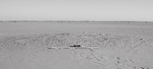
5 burials; hence our decision to carry out a second campaign to examine as many as we could. A total of 65 mounds have been tested. Their diameters ranged from 1 to 15m and their height from 100 to 300mm. They were made of a mixture of silt and sand displaying no internal stratigraphy and underlying a thin layer of gravel and aeolian sand and, consequently, they were interpreted as natural features. In point of fact, only 29, mostly located in the western part of the area, contained archaeological remains. These were not only Neolithic graves but also, most surprisingly, isolated artefacts and shafts filled with gravel. Altogether 53 graves containing a total number of 55 skeletons have been excavated. Except for three, which were discovered in flat areas, all were found in the mounds, which contained between one and six burials each. All are small shallow shafts containing a single burial (Figure 3, Colour plate XX), except for two that contained double interments. All skeletons were lying on their side in a very contracted position with no particular orientation. They include 34 adults, 18 juveniles and three undeterminable individuals. The bones were so poorly preserved that determining the sex and adults age at death was almost impossible. Only a few had associated material, never abundant, that included in total several pottery vessels, one mace-head (Colour plate XXI), two bone awls and some personal adornment, the latter being restricted to several strings of amazonite beads, two zeolite curved lip plugs (Plate 7) and three ivory armlets. Besides the graves, some of the mounds, eight of which were devoid of burials, yielded pottery vessels that were not Figure 3. A Neolithic grave. 37 Plate 7. Zeolite lip-plugs from graves. associated with any particular feature and, more surprisingly, 43 rounded shallow shafts filled with gravel, 25 of which contained pottery vessels and/or sandstone grinders but no human bones. The most interesting of the isolated finds was a complex deposit that included polished celts, bone tools and numerous microliths that certainly were packed originally in a bag of which all material evidence has since vanished. The bone tools included the hafts of three sickles, which had been grooved on one side for inserting the microliths found in the deposit. Most of the pottery vessels found in the graves, the mounds and the gravel shafts (Figure 4, Plates 8-11) display strong affinities with those of cemetery KDK1 at Kadruka (Reinold 2001), including decorated caliciform beakers, which, significantly, never occurred in graves. In the absence of C- 14 dating, the Neolithic occupation of el-multaga should, therefore, be provisionally dated like KDK1 somewhere between 4500 and 4000 BC. Conclusion Apart from an eroded Christian site and Middle Palaeolithic concentrations of artefacts associated with quarrying and tool-making activity, salvage work carried out at el-multaga mainly dealt with sites related to two main phases of the earliest ceramic tradition of the Upper Middle Nile, most usually referred to in the literature as Mesolithic and Neolithic. The Mesolithic is mainly documented by an extensive settlement that provided large quantities of lithic and ceramic material related to the dotted phase of the Wavy-Line tradition, while the Neolithic is documented by settlements and burial sites that provided pottery vessels displaying strong affinities with those from cemetery KDK1 at Kadruka. The small size of the Neolithic settlements, the lack of grave concentrations and the scarcity of grave goods contrast with what is known from other sites of the same horizon excavated in Southern Nubia and Central Sudan such as Kadero, el-ghaba and Kadruka, where intensive occupation is associated with large and medium-sized cemeteries. They certainly indicate an adaptation based on nomadism or semi-nomadism, which may have been related to the


6 Plate 8. Neolithic pottery vessel. Plate 9. Neolithic pottery vessel. Plate 10. Neolithic pottery vessel. Plate 11. Neolithic caliciform beaker. Figure 4. Neolithic pottery vessels; 1. MTG 37/1/1, 2. MTG 18/1/1/1, 3. MTG 37/1/1, 4. MTG 19/6/1. 38
7 exploitation of the large wadis that join the Nile in the area. The discovery of three sickle shafts shows that such exploitation included the gathering of cereals, whether wild or domesticated. El-Multaga has, therefore, revealed an aspect of the Neolithic of the Upper Main Nile that would certainly not have been documented without salvage pressure. It is significant in this respect that the survey carried out in by Joel Shiner in a larger area did not lead to the discovery of any Neolithic burial site, not even a single grave. Acknowledgements The following participants have contributed to the field work at el-multaga: Francis Geus, director; Yves Lecointe, assistant director; Carolina Geus-de Bosch Kemper, recorder; Jan Moeyersons, geomorphologist; Frédéric Adam, Vincent Francigny, Raphaël Pouriel and Suad Osman Mahgoub, archaeologists; Philip Van Peer and Elena Garcea, prehistorians; David Peressinotto and Aurore Schmitt, physical anthropologists; Ali Mirghani, Fawzi Hassan, Habab Idriss and Nakhla Mustafa, inspectors of NCAM; Aiman el-tayeb, curator of NCAM; Awadallah Ali el-basha, foreman. Bibliography Hinkel, F The Archaeological Map of the Sudan. A Guide to its Use and Explanation of its Principles. Berlin. Reinold, J Kadruka and the Neolithic in the Northern Dongola Reach, Sudan & Nubia 5, Shiner, J. L., A. E. Marks, V. Chmielewski, J. de Heinzelin, T. R. Hays, F. Servello, F. Munday and R. Ferring The Prehistory and Geology of Northern Sudan. Dallas. 39
8
Merowe Dam Archaeological Salvage Project (MDASP)
") Merowe Dam Archaeological Salvage Project (MDASP) Salah Mohamed Ahmed Introduction The idea of building a dam at the 4 th Cataract of the Nile dates to the period of the Anglo-Egyptian administration in
Merowe Dam Archaeological Salvage Project (MDASP) Salah Mohamed Ahmed Introduction The idea of building a dam at the 4 th Cataract of the Nile dates to the period of the Anglo-Egyptian administration in
Report of the Survey in the Wadi Abu Dom,
 Report of the Survey in the Wadi Abu Dom, 24.2.-16.3.2009 (funded by the Gerda Henkel-Foundation, Germany) Angelika Lohwasser Free University Berlin, Germany 1. Staff Gabriel, Prof. Dr. Baldur, Geographer,
The Neolithic of the Fourth Cataract Marek Chłodnicki, Muzeum Archeologiczne, Poznań
 The Neolithic of the Fourth Cataract Marek Chłodnicki, Muzeum Archeologiczne, Poznań The Fourth Cataract region was penetrated archaeologically already in the 19 th century, but early travelers took notice
Archaeologists for Hire: An In-Class Activity
 Archaeologists for Hire: An In-Class Activity Beyond Grades: Capturing Authentic Learning Conference Welcome to the Marveloso Valley, a fictional valley on the central coast of Peru. Over the decades,
TH E FIRST SEASON of investigations at the
 QUSEIR AL-QADIM Janet H. Johnson & Donald Whitcomb TH E FIRST SEASON of investigations at the ancient port of Quseir al-qadim on the Red Sea in Egypt took place in winter, 1978; the investigations were
Following the initial soil strip archaeology is sprayed up prior to planning and excavation
 Barton Quarry & Archaeology Over the past half century quarries have been increasingly highlighted as important sources of information for geologists, palaeontologists and archaeologists, both through
Archaeological Investigation of Coloane, Macau
 Archaeological Investigation of Coloane, Macau Received 13 March 1974" W. KELLY AND W. MEACHAM INTRODUCTION UP UNTIL July 1972, when a field survey of Coloane Island was undertaken by members of the Hong
South from Kadruka: the Neolithic in the Northern Dongola Reach, Sudan
 Recent Research Into the Stone Age of Northeastem Africa Studies in African Archaeology 7 Poznan Archaeological Museum 2000 Derek A. Welsby South from Kadruka: the Neolithic in the Northern Dongola Reach,
Archaeological Investigations Project South East Region SOUTHAMPTON 2/842 (C.80.C004) SU
 SU") SOUTHAMPTON City of Southampton 2/842 (C.80.C004) SU 4382 1336 125 BITTERNE ROAD WEST, SOUTHAMPTON Report on the Archaeological Evaluation Excavation at 125 Bitterne Road West, Southampton Russel, A. D
SOUTHAMPTON City of Southampton 2/842 (C.80.C004) SU 4382 1336 125 BITTERNE ROAD WEST, SOUTHAMPTON Report on the Archaeological Evaluation Excavation at 125 Bitterne Road West, Southampton Russel, A. D
The Archaeology of Cheltenham
 The Archaeology of Cheltenham The archaeology collection of The Wilson contains a rich quantity of material relating to the prehistoric and Roman occupation of the North Cotswolds and parts of the Severn
IMTO Italian Mission to Oman University of Pisa 2011B PRELIMINARY REPORT (OCTOBER-DECEMBER 2011)
") IMTO Italian Mission to Oman University of Pisa 2011B PRELIMINARY REPORT (OCTOBER-DECEMBER 2011) The 2011B research campaign took place in the area around Salut from October, 19 th, to December, 16 th.
IMTO Italian Mission to Oman University of Pisa 2011B PRELIMINARY REPORT (OCTOBER-DECEMBER 2011) The 2011B research campaign took place in the area around Salut from October, 19 th, to December, 16 th.
A FIELDWALKING PROJECT AT HOLLINGBURY, BRIGHTON. by JOHN FUNNELL
 Introduction A FIELDWALKING PROJECT AT HOLLINGBURY, BRIGHTON by JOHN FUNNELL Members of the Brighton and Hove Archaeological Society walked the field at Hollingbury during the months of December 1991 and
oi.uchicago.edu TALL-E BAKUN
 TALL-E BAKUN ABBAS ALIZADEH After I returned in September 1991 to Chicago from Cambridge, Massachusetts, I began preparing for publication the results of 1937 season of excavations at Tall-e Bakun, one
archeological site LOS MILLARES
 archeological site LOS MILLARES Aerial view of the plain of Los Millares between the Rambla de Huéchar and the River Andarax The archaeological site of Los Millares is located in the township of Santa
Investigations at Jackdaw Crag Field, Boston Spa, SE , in by Boston Spa Archaeology and Heritage Group
 0 Investigations at Jackdaw Crag Field, Boston Spa, SE 42304632, in 2006-7 by Boston Spa Archaeology and Heritage Group www.bostonspaheritage.co.uk Preface and Summary This report records the results of
An archaeological watching brief on land adjacent to 50 Rosebery Avenue, Colchester, Essex May/June 2003
 An archaeological watching brief on land adjacent to 50 Rosebery Avenue, Colchester, Essex May/June 2003 report prepared by C Crossan on behalf of Highfield Homes Ltd NGR: TM 0035 2500 CAT project ref.:
Report on the excavations on the site Novopokrovskoe II in V. Kol'chenko, F. Rott
 Report on the excavations on the site Novopokrovskoe II in 2016 V. Kol'chenko, F. Rott In 2016 the Novopokrovskiy archeological group of the Institute of History and Heritage of the National Academy of
ARCHAEOLOGICAL INVESTIGATIONS IN GUADALUPE, NORTHEAST HONDURAS
 ARCHAEOLOGICAL INVESTIGATIONS IN GUADALUPE, NORTHEAST HONDURAS Markus Reindel, Franziska Fecher and Peter Fux Archaeological investigations in Honduras have focused on the western, Mesoamerican part of
ANNUAL REPORT: ANCIENT METHONE ARCHAEOLOGICAL PROJECT 2014 FIELD SCHOOL
 ANNUAL REPORT: ANCIENT METHONE ARCHAEOLOGICAL PROJECT 2014 FIELD SCHOOL Director(s): Co- Director(s): Professor Sarah Morris, Cotsen Institute of Archaeology, UCLA John K. Papadopoulos, Cotsen Institute
Jneneh in the Upper Wadi az-zarqa, in North Central Jordan, First Season 2011.
 Jneneh in the Upper Wadi az-zarqa, in North Central Jordan, First Season 2011. Khaled Douglas Jneneh is located in the north-western periphery of the city of Zarqa (grid ref. 250.88E 165.25N), in North
Archaeological Watching Brief on land at Alpha, Gore Road, Eastry, Kent July 2010
 Archaeological Watching Brief on land at Alpha, Gore Road, Eastry, Kent July 2010 SWAT. Archaeology Swale and Thames Archaeological Survey Company School Farm Oast, Graveney Road Faversham, Kent ME13 8UP
Wessex Archaeology. Little Stubbings, West Amesbury, Salisbury, Wiltshire. Archaeological Watching Brief. Ref:
 Wessex Archaeology Little Stubbings, West Amesbury, Salisbury, Wiltshire Ref: 63280.02 March 2007 LITTLE STUBBINGS, WEST AMESBURY, NR SALISBURY, WILTSHIRE ARCHAEOLOGICAL WATCHING BRIEF Prepared for: P
BRONZE AGE FIELD SYSTEM AT SOUTHAMPTON AIRPORT
 Proc. Hampshire Field Club Archaeol. Soc. 65, 2010, 1-6 (Hampshire Studies 2010) BRONZE AGE FIELD SYSTEM AT SOUTHAMPTON AIRPORT By J SULIKOWSKA With contributions by LORRAINE MEPHAM and CHRIS J STEVENS
An archaeological excavation at 193 High Street, Kelvedon, Essex September 2009
 An archaeological excavation at 193 High Street, Kelvedon, Essex September 2009 report prepared by Ben Holloway and Howard Brooks on behalf of Marden Homes CAT project ref.: 09/4g NGR: TL 8631 1913 (c)
Gebel Barkal (Sudan) No 1073
 No 1073") Gebel Barkal (Sudan) No 1073 1. BASIC DATA State Party : Republic of Sudan Name of property: Gebel Barkal and the Sites of the Napatan Region Location: Northern state, province of Meroe Date received:
Gebel Barkal (Sudan) No 1073 1. BASIC DATA State Party : Republic of Sudan Name of property: Gebel Barkal and the Sites of the Napatan Region Location: Northern state, province of Meroe Date received:
Land off Birdie Way, Rush Green, Hertford, Hertfordshire
 Land off Birdie Way, Rush Green, Hertford, Hertfordshire An Archaeological Evaluation for Bride Hall Development Limited by Sarah Coles Thames Valley Archaeological Services Site Code RGH00/ 01 January
An archaeological evaluation at 19 Beverley Road, Colchester, Essex February 2003
 An archaeological evaluation at 19 Beverley Road, Colchester, Essex February 2003 report prepared by Carl Crossan on behalf of Mr G and Mrs H Prince NGR: TL 98655 24844 CAT project ref.: 03/2d Planning
Ancient Kingdoms of Sudan. 12 Days
 Ancient Kingdoms of Sudan 12 Days Ancient Kingdoms of Sudan On this extraordinary adventure through rarely visited Sudan, journey across breathtaking deserts, ancient pyramids, and buzzing markets. Cruise
How the Nile River Led to Civilization in Ancient Egypt
 How the Nile River Led to Civilization in Ancient Egypt By USHistory.org, adapted by Newsela staff on 03.07.17 Word Count 786 Level 950L TOP: This photo, taken around 1915, shows the flooding of the Nile
ROUKEN GLEN: BANDSTAND 2015 DATA STRUCTURE REPORT
 ROUKEN GLEN: BANDSTAND 2015 DATA STRUCTURE REPORT Author (s) Ian Hill Editors Report Date June 2015 Working Partners Funders Phil Richardson East Renfrewshire Council East Renfrewshire Council, Heritage
Gorse Stacks, Bus Interchange Excavations Interim Note-01
 Gorse Stacks, Bus Interchange Excavations 2015 Prepared for: Cheshire West & Chester Council Interim Note-01 1 Introduction & Summary Background Since c. 2000 investigations associated with redevelopment
The Semna South Project
 The Semna South Project Louis V. Zabkar For those who have never visited the area of southern Egypt and northern Sudan submerged by the waters of the new Assuan High Dam, and who perhaps find it difficult
Report of the Project "Wadi Abu Dom Itinerary" Fifth Season, (fieldactivity)
") Report of the Project "Wadi Abu Dom Itinerary" Fifth Season, 18.1.-16.3.2014 (fieldactivity) (funded by the German Research Foundation, Germany, and the Qatar Sudan Archaeological Project) Angelika Lohwasser
Report of the Project "Wadi Abu Dom Itinerary" Fifth Season, 18.1.-16.3.2014 (fieldactivity) (funded by the German Research Foundation, Germany, and the Qatar Sudan Archaeological Project) Angelika Lohwasser
4. Bronze Age Ballybrowney, County Cork Eamonn Cotter
 4. Bronze Age Ballybrowney, County Cork Eamonn Cotter Illus. 1 Location map of the excavated features at Ballybrowney Lower (Archaeological Consultancy Services Ltd, based on the Ordnance Survey Ireland
House Decoration in Egyptian Nubia Prior to 1964
 Dotawo: A Journal of Nubian Studies Volume 5 Nubian Women Article 4 2018 House Decoration in Egyptian Nubia Prior to 1964 Armgard Goo-Grauer goograuer@icloud.com Follow this and additional works at: https://digitalcommons.fairfield.edu/djns
RESEARCH BULLETIN. Parks Canada. Parcs Canada. Cette publication est disponible en français.
 RESEARCH BULLETIN No. 201 August 1983 Scratching the Surface-Three Years of Archaeological Investigation in Wood Buffalo National Park, Alberta/N.W.T.-Preliminary Summary Report Marc G. Stevenson Archaeology,
Antinoupolis. Ongoing Destruction. Pre-2006 crops. Modern cemetery covering. ancient cemetery. Antinoupolis, ancient city. North cemetery (ancient).
.") Antinoupolis Ongoing Destruction Ongoing Destruction North cemetery (ancient). Pre-2006 crops Modern cemetery covering ancient cemetery. Antinoupolis, ancient city. Modern village of el Sheikh Abada Nile
Antinoupolis Ongoing Destruction Ongoing Destruction North cemetery (ancient). Pre-2006 crops Modern cemetery covering ancient cemetery. Antinoupolis, ancient city. Modern village of el Sheikh Abada Nile
An archaeological evaluation at 14 Vineyard Street, Colchester, Essex March 2006
 An archaeological evaluation at 14 Vineyard Street, Colchester, Essex March 2006 report prepared by Ben Holloway commissioned by Colchester Borough Council CAT project code: 06/4b Colchester Museums accession
Archaeological Monitoring at Ham Farm, Ham Road, Faversham, Kent
 Archaeological Monitoring at Ham Farm, Ham Road, Faversham, Kent NGR: 601750.0mE 162695.0mN Site Code HAM/WB/12 Report for A.J. Bray SWAT ARCHAEOLOGY Swale and Thames Archaeological Survey Company The
By : K. Blouin, Th. Faucher, N. Hudson, M. Kenawi, A. Kirby, R. Mairs, G. Marchiori, M. Van Peene
 THMUIS, A NEW LAND IN THE EASTERN NILE DELTA FIRST CANADIAN MISSION AT THMUIS By : K. Blouin, Th. Faucher, N. Hudson, M. Kenawi, A. Kirby, R. Mairs, G. Marchiori, M. Van Peene The first Canadian Mission
Excavations in a Medieval Market Town: Mountsorrel, Leicestershire,
 Excavations in a Medieval Market Town: Mountsorrel, Leicestershire, by John Lucas Mountsorrel is situated 12 kms north of Leicester and forms a linear settlement straddling the A6, Leicester to Derby road.
Remote Sensing into the Study of Ancient Beiting City in North-Western China
 Dingwall, L., S. Exon, V. Gaffney, S. Laflin and M. van Leusen (eds.) 1999. Archaeology in the Age of the Internet. CAA97. Computer Applications and Quantitative Methods in Archaeology. Proceedings of
FIELD BOUNDARIES, A MEDIEVAL STRUCTURE AND DEAD SHEEP AT IWADE, KENT
 FIELD BOUNDARIES, A MEDIEVAL STRUCTURE AND DEAD SHEEP AT IWADE, KENT Pre-Construct Archaeology Limited Unit 54, Brockley Cross Business Centre, 96 Endwell Road, Brockley, London SE4 2PD tel: 020 7732 3925
IKLAINA ARCHAEOLOGICAL PROJECT 2016 FIELD REPORT Michael B. Cosmopoulos
 IKLAINA ARCHAEOLOGICAL PROJECT 2016 FIELD REPORT Michael B. Cosmopoulos Introduction The overarching objective of the Iklaina project is to test existing hierarchical models of state formation in Greece
ARCHAEOLOGICAL S E R V I C E S. Phase 5, Grimsby Road, Cippenham, Slough, Berkshire. Archaeological Recording Action.
 T H A M E S V A L L E Y ARCHAEOLOGICAL S E R V I C E S Phase 5, Grimsby Road, Cippenham, Slough, Berkshire Archaeological Recording Action by Andy Taylor Site Code: GRC13/57 (SU 9493 7977) Phase 5, Eltham
As both one of the few substantially preserved pharaonic Egyptian. expulsion, the site of Deir el-ballas is of great archaeological and historic
 The 2017 Season at Deir el-ballas Peter Lacovara As both one of the few substantially preserved pharaonic Egyptian settlements as well as the forward capital for the Theban kings during the Hyksos expulsion,
SUDAN. The Kingdom of the Black Pharaohs. GUARANTEED DEPARTURES (min. 4 pax)
") SUDAN The Kingdom of the Black Pharaohs 10 days all accommodated tour + possible extension to Soleb GUARANTEED DEPARTURES (min. 4 pax) This tour shows all the major archaeological sites of the Northern
SUDAN The Kingdom of the Black Pharaohs 10 days all accommodated tour + possible extension to Soleb GUARANTEED DEPARTURES (min. 4 pax) This tour shows all the major archaeological sites of the Northern
IAS Prelims Exam: Ancient History NCERT Questions: The Harappan Civilisation Set II
 IAS Prelims Exam: Ancient History NCERT Questions: The Harappan Civilisation Set II Questions asked from Ancient Indian History section in IAS Prelims Exam are quite easy but the candidates need to memorise
FOUNDATIONS OF ARCHAEOLOGY A WALK IN VERNDITCH CHASE
 FOUNDATIONS OF ARCHAEOLOGY A WALK IN VERNDITCH CHASE 1. A Tale of two Long Barrows Long barrows were constructed as earthen or drystone mounds with flanking ditches and acted as funerary monuments during
The Italian Archaeological Mission in Sudan Ca Foscari University of Venice
 The Italian Archaeological Mission in Sudan Ca Foscari University of Venice Karima (Sudan) November-December 2012 The 2012 season of the Italian Archaeological Mission at Jebel Barkal was carried out between
AN ARCHAEOLOGICAL ASSESSMENT OF BOERNE CITY PARK, KENDALL COUNTY, TEXAS. Thomas C. Kelly and Thomas R. Hester
 AN ARCHAEOLOGICAL ASSESSMENT OF BOERNE CITY PARK, KENDALL COUNTY, TEXAS Thomas C. Kelly and Thomas R. Hester Center for Archaeological Research The University of Texas at San Antonio Archaeological Survey
Street Sweeper Dump Site, RAF Lakenheath ERL 160
 ARCHAEOLOGICAL MONITORING REPORT Street Sweeper Dump Site, RAF Lakenheath ERL 160 A REPORT ON THE ARCHAEOLOGICAL MONITORING, 2006 (Planning app. no. F/2006/0021/GOV) Jo Caruth Field Team Suffolk C.C. Archaeological
THE EL-QITAK PROJECT. oi.uchicago.edu
 oi.uchicago.edu THE EL-QITAK PROJECT T H O M A S - L - M C C L E L L A N T he 1987 season at el-qitar ran from May 2 t o July 29th and marked the last major season of excavation there because the site
Stone Age Flint Artefacts Pack
 WARNING: The items contained within this pack are made of real flint and are extremely sharp Only use under adult supervision and handle with caution. Not suitable for children under 7 years of age. Explain
New Studies in the City of David The Excavations
 The 2013-2014 Excavations Israel Antiquities Authority The intensive archaeological work on the city of David hill during the period covered in this article has continued in previously excavated areas
Settlement Patterns West of Ma ax Na, Belize
 SETTLEMENT PATTERNS WEST OF MA AX NA, BELIZE 1 Settlement Patterns West of Ma ax Na, Belize Minda J. Hernke Faculty Sponsor: Kathryn Reese-Taylor, Department of Sociology/Archaeology ABSTRACT The focus
Archaeologists unearth tombs in ancient Nubia
 Archaeologists unearth tombs in ancient Nubia Mon, Mar 05, 2018 Tombs, steles, and lintels have just been unearthed by an international team, with largest collection of Meroitic inscriptions, the oldest
Underwater Archaeological Expedition on Ancient Town Akra in 2012 (Eastern Crimea)
") Kyiv National Taras Shevchenko University Department of Ancient and Medieval History State Hermitage Museum V. Vakhonieiev, S. Solovyov Underwater Archaeological Expedition on Ancient Town Akra in 2012
Kyiv National Taras Shevchenko University Department of Ancient and Medieval History State Hermitage Museum V. Vakhonieiev, S. Solovyov Underwater Archaeological Expedition on Ancient Town Akra in 2012
CARLUNGIE EARTH HOUSE
 Property in Care (PIC) ID: PIC015 Designations: Scheduled Monument (SM90059) Taken into State care: 1953 (Guardianship) Last reviewed: 2004 HISTORIC ENVIRONMENT SCOTLAND STATEMENT OF SIGNIFICANCE CARLUNGIE
aiton.new 1/4/04 3:48 AM Page 2
 aiton.new 1/4/04 3:48 AM Page 2 Below: An aerial view of area A of the excavations. A massive square building that appears to be a fortress was discovered in this area at the top of the tell. aiton.new
The Coach House, Mill Lane, Cookham, Berkshire
 The Coach House, Mill Lane, Cookham, Berkshire An Archaeological Watching Brief For Ms Sophia Butler by Stephen Hammond Thames Valley Archaeological Services Ltd Site Code CMC 03/104 October 2003 Summary
Lordenshaw. What are cup & ring marks?
 Lordenshaw Lordenshaw hill has one of the largest clusters of ancient cup and ring marked stones in the UK. We ve chosen four interesting spots we d like to share with you. What are cup & ring marks? The
III. THE EARLY HELLADIC POTTERY FROM THE MASTOS IN THE BERBATI VALLEY, ARGOLID
 III. THE EARLY HELLADIC POTTERY FROM THE MASTOS IN THE BERBATI VALLEY, ARGOLID by JEANNETTE FORSÉN The Swedish investigations of the hillock Mastos in the western part of the Berbati valley, ca. 3 km south
Amarna Workers Village
 Amarna Workers Village The Egyptian city of Amarna was the pet building project of the pharaoh Akhenaten, who oversaw construction of his new capital between 1346 and 1341 BCE. The city was largely abandoned
Sudanese Nubia 8 Days/7 Nights All Meals Included All Gratuities Included
 Sudanese Nubia 8 Days/7 Nights All Meals Included All Gratuities Included Featuring: Mogran Park. National Museum. Khalifa Museum. Old Dongola. Jebel Barkal. Kurru. Pyramids of Nuri. Gazali Valley and
Archaeological Watching Brief at the Brick Stables and Wagon Lodge, Abbey Barns, Abbey Road, Faversham, Kent September 2010
 Archaeological Watching Brief at the Brick Stables and Wagon Lodge, Abbey Barns, Abbey Road, Faversham, Kent September 2010 SWAT. Archaeology Swale and Thames Archaeological Survey Company School Farm
Cholesbury New House, Parrots Lane, Cholesbury, Buckinghamshire
 Cholesbury New House, Parrots Lane, Cholesbury, Buckinghamshire An Archaeological Watching Brief For Mr Martin Wood by Sean Wallis Thames Valley Archaeological Services Ltd Site Code PLC 06/135 March 2007
Jane C. Waldbaum Archaeological Field School Scholarship - Report.
 Jane C. Waldbaum Archaeological Field School Scholarship - Report. Eastern Boeotia Archaeological Project, 2017 Novella Nicchitta Figure 1 EBAP's team for 2017 This year I had the pleasure of participating
Archaeological Investigations Project Yorkshire & Humberside Region NORTH YORKSHIRE 2/1113 (C.36.J002) SD
 SD") NORTH YORKSHIRE Craven 2/1113 (C.36.J002) SD 93607800 CRAY BECK, BUCKDEN, UPPER WHARFEDALE Cray Beck, The Archaeological Investigation of a Stone Feature Archetype Wensleydale : ArcheType Archaeological
NORTH YORKSHIRE Craven 2/1113 (C.36.J002) SD 93607800 CRAY BECK, BUCKDEN, UPPER WHARFEDALE Cray Beck, The Archaeological Investigation of a Stone Feature Archetype Wensleydale : ArcheType Archaeological
In 2014 excavations at Gournia took place in the area of the palace, on the acropolis, and along the northern edge of the town (Fig. 1).
.") Gournia: 2014 Excavation In 2014 excavations at Gournia took place in the area of the palace, on the acropolis, and along the northern edge of the town (Fig. 1). In Room 18 of the palace, Room A, lined
Gournia: 2014 Excavation In 2014 excavations at Gournia took place in the area of the palace, on the acropolis, and along the northern edge of the town (Fig. 1). In Room 18 of the palace, Room A, lined
Document History continued Revision: Date: Prepared by: Checked by: Approved by: Reason for Issue:
 Document History continued Revision: Date: Prepared by: Checked by: Approved by: Reason for Issue: 1.0 29/10/2013 Gary Evans Andy Shelley Richard Brown For Acceptance Fieldwork Report CRL Ltd, 2014 Fieldwork
Unit 9 The Middle East SG 1 - Physical Geography, Population & Demographics
 Unit 9 The Middle East SG 1 - Physical Geography, Population & Demographics I. Physical Geography A. The Middle East includes southwestern Asia and North Africa. 1. The name is Eurocentric. Middle East
How the Nile River Led to Civilization in Ancient Egypt
 How the Nile River Led to Civilization in Ancient Egypt By USHistory.org on 03.07.17 Word Count 1,108 Level MAX TOP: This photo, taken around 1915, shows the flooding of the Nile River, which happens each
The Parthian newfound area review in the central part of the Iranian Plateau: Ravanj-e Josheghan-e ghali
 International Research Journal of Applied and Basic Sciences 2015 Available online at www.irjabs.com ISSN 2251-838X / Vol, 9 (9): 1517-1521 Science Explorer Publications The Parthian newfound area review
CAMEROON. Overview. Selected Research Results. The Central Courtyard Area (Unit 1)
") CAMEROON Research at DGB-1, Northern Cameroon, 2008 Scott MacEachern, Joseph-Marie Datouang Djoussou and Rébecca Janson Scott MacEachern Department of Sociology and Anthropology Bowdoin College Brunswick,
CAMEROON Research at DGB-1, Northern Cameroon, 2008 Scott MacEachern, Joseph-Marie Datouang Djoussou and Rébecca Janson Scott MacEachern Department of Sociology and Anthropology Bowdoin College Brunswick,
SUDAN. The Study Area. Introduction. The Samples
 SUDAN Sorghum Exploitation at Kassala and Its Environs, North Eastern Sudan in the Second and First Millennia BC Alemseged Beldados Universita Degli Studi di Napoli, L Orientale, Dipartimento di Studi
SUDAN. The Kingdom of the Black Pharaohs
 SUDAN The Kingdom of the Black Pharaohs 10 days all accommodated tour + possible extension to Soleb Season 2015-2016 GUARANTEED DEPARTURES (min. 4 pax) This tour shows all the major archaeological sites
Florence House, High Street, Hurley, Berkshire
 Florence House, High Street, Hurley, Berkshire An Archaeological Watching Brief For Mr Michael Waterhouse by Jo Pine Thames Valley Archaeological Services Ltd Site Code FHH04/52 May 2004 Summary Site name:
S E R V I C E S. Land to the rear of Ashdown, Basingstoke Road, Spencers Wood, Reading, Berkshire. Archaeological Evaluation.
 T H A M E S V A L L E Y ARCHAEOLOGICAL S E R V I C E S Land to the rear of Ashdown, Basingstoke Road, Spencers Wood, Reading, Berkshire Archaeological Evaluation by Susan Porter Site Code: ASW12/21 (SU
AN ARCHAEOLOGICAL SURVEY OF PROPOSED AREAS FOR ALTERNATE ROADWAYS AT OLMOS DAM, SAN ANTONIO, TEXAS
 AN ARCHAEOLOGICAL SURVEY OF PROPOSED AREAS FOR ALTERNATE ROADWAYS AT OLMOS DAM, SAN ANTONIO, TEXAS Dalli! Brown Center for Archaeological Research The Unh'ersity of Texas at San Antonio Archaeological
Henderson Mess, RAF Halton, Buckinghamshire
 Henderson Mess, RAF Halton, Buckinghamshire An archaeological watching brief for Stepnell Ltd by Stephen Hammond Thames Valley Archaeological Services Ltd Site Code RHA03/85 October 2003 Summary Site name:
ULSTER ARCHAEOLOGICAL SOCIETY
 ULSTER ARCHAEOLOGICAL SOCIETY Survey Report: No. 52 Survey and surface artefact collection at Ballytaylor, County Antrim UAS/14/01 In association with HENRY WELSH, KARA WARD AND MOIRA O ROURKE 2 Ulster
The early Ramesside occupants of tomb MIDAN.05
 The early Ramesside occupants of tomb MIDAN.05 Marilina Betrò and Gianluca Miniaci continue the exploration of tomb MIDAN.05 in the Theban Necropolis. Discovered in 2004 by the archaeological expedition
Chapter 7 Geography and the Early Settlement of Egypt, Kush, and Canaan
 Chapter 7 Geography and the Early Settlement of Egypt, Kush, and Canaan How did geography affect early settlement in Egypt, Kush, and Canaan? Section 7.1 - Introduction RF/NASA//Corbis This satellite photograph
The Tel Burna Archaeological Project Report on the First Season of Excavation, 2010
 The Tel Burna Archaeological Project Report on the First Season of Excavation, 2010 By Itzick Shai and Joe Uziel Albright Institute for Archaeological Research Jerusalem, Israel April 2011 The site of
Documentation of Mosaic Tangible Heritage in Jordan Jarash Governorate
 Documentation of Mosaic Tangible Heritage in Jordan Jarash Governorate Catreena Hamarneh, Abdel Majeed Mjalli, Mohamed al-balawneh Introduction In the year 2005 a project was launched to build up a data
Draft Report. 7. Excavations in the temenos gateway, Area (TG5) Author - D. A. Welsby Period 1-2. Period 1. Period 2. Derek A.
 Author - D. A. Welsby Period 1-2. Period 1. Period 2. Derek A.") 7. Excavations in the temenos gateway, Area (TG5) Derek A. Welsby When Griffith excavated the temples at Kawa in 1929-31, work followed by that of Macadam and Kirwan in the winter of 1935-6, the temenos
7. Excavations in the temenos gateway, Area (TG5) Derek A. Welsby When Griffith excavated the temples at Kawa in 1929-31, work followed by that of Macadam and Kirwan in the winter of 1935-6, the temenos
REPORT ON THE 2004 FIELDWORK SEASON OF THE UNIVERSITY OF CALIFORNIA BERKELEY AT THE ARCHAEOLOGICAL SITE OF EL-HIBEH, BENI-SUEF GOVERNORATE
 REPORT ON THE 2004 FIELDWORK SEASON OF THE UNIVERSITY OF CALIFORNIA BERKELEY AT THE ARCHAEOLOGICAL SITE OF EL-HIBEH, BENI-SUEF GOVERNORATE By Carol A. Redmount, Project Director The archaeological site
B 1200: The Napatan palace and the Aspelta throne room.
 B 1200: The Napatan palace and the Aspelta throne room. The labyrinthine mud brick walls southwest of B 800 are the remains of the Napatan palace, designated "B 1200," at Jebel Barkal (fig. 1). Until now
Schela Cladovei, Romania
 University of Edinburgh Archaeology Field School, Romania Set in one of the most remarkable archaeological landscapes in southeastern Europe, the Iron Gates, the site of, which was occupied in turn by
The Year in Review 2014, Beothuk Institute Inc. We have had several highlights this year. At the AGM in May there were two guest speakers, Dale
 The Year in Review 2014, Beothuk Institute Inc. We have had several highlights this year. At the AGM in May there were two guest speakers, Dale Jarvis set the stage for the story gathering that the Beothuk
Northamptonshire Archaeology
 Northamptonshire Archaeology A programme of archaeological observation, investigation and recording at St Andrews Church, Spratton, Northamptonshire Northamptonshire Archaeology 2 Bolton House Wootton
The Greek-Swedish-Danish Excavations at Kastelli, Khania 2010 a short report
 The Greek-Swedish-Danish Excavations at Kastelli, Khania 2010 a short report During six weeks from 19 July to 27 August the Greek-Swedish-Danish Excavations continued work in the Ag. Aikaterini Square
The search results explanations of hydrological data
 Introduction The search results explanations of hydrological data Depending on the parameter, the instrumental measuring or visual observation method is used for the hydrological observations. Instrumentally
Vale of Pewsey: field walking
 Vale of Pewsey: field walking Report No. 167. 0405 Report date Oct 2012 Authors L. Amadio MSc and B. Clarke MSc Acknowledgements Dr N Snashall kindly commented on the flint assemblage. Land owners Brian
Wheatlands House, Fleet Hill, Finchampstead, Berkshire
 Wheatlands House, Fleet Hill, Finchampstead, Berkshire An Archaeological Watching Brief For JCA International by James McNicoll-Norbury Thames Valley Archaeological Services Ltd Site Code WFF 08/26 August
CARN BAN LONG CAIRN HISTORIC ENVIRONMENT SCOTLAND STATEMENT OF SIGNIFICANCE. Property in Care (PIC) ID: PIC059 Designations:
 ID: PIC059 Designations:") Property in Care (PIC) ID: PIC059 Designations: Scheduled Monument (SM90051) Taken into State care: 1962 (Guardianship) Last reviewed: 2004 HISTORIC ENVIRONMENT SCOTLAND STATEMENT OF SIGNIFICANCE CARN
Property in Care (PIC) ID: PIC059 Designations: Scheduled Monument (SM90051) Taken into State care: 1962 (Guardianship) Last reviewed: 2004 HISTORIC ENVIRONMENT SCOTLAND STATEMENT OF SIGNIFICANCE CARN
Archaeological Evaluation Report
 Holywell House Osney Mead Oxford o a November 2007 Client: Knowles and Son Issue N o : 1 OA Job N o : 3826 Planning Ref N o : 02/01800/FUL NGR: SP 502 055 Client Name: Knowles and Son Client Ref No: Document
47I THE LAS ANIMAS GLACIER.
 THE LAS ANIMAS GLACIER. ONE of the largest of the extinct glaciers of the Rocky Mountains was that which occupied the valley of the Las Animas river. This stream originates in the San Juan mountains in
218 R. S. BORAAS AND S. H. HORN
 were able to show a sequence of ceramic corpora much more fully representative than those available from the occupation surfaces and structures higher on the mound. This ceramic series obtained from D.