Report of the Project "Wadi Abu Dom Itinerary" Fifth Season, (fieldactivity)
|
|
|
- Leo Lloyd
- 6 years ago
- Views:
Transcription
1 Report of the Project "Wadi Abu Dom Itinerary" Fifth Season, (fieldactivity) (funded by the German Research Foundation, Germany, and the Qatar Sudan Archaeological Project) Angelika Lohwasser University of Muenster, Germany 1. Staff Lohwasser, Prof. Dr. Angelika, Archaeologist, Project Director Karberg, Tim, M.A., Archaeologist, Field Director Eigner, Dr. Dieter, Architect Eger, Jana M.A., Archaeologist, Remote Sensing, Coordination QSAP-project Helmbold-Doyè, Dr. Jana, Pottery specialist Mohammed el Toum, (NCAM) Lange, Rayk, Mechanics Aufderhaar, Wienke, Student of Archaeology Beckmann, Carina, Student of Archaeology Dörbandt, Anne, Student of Archaeology Petereit, Julia, Student of Archaeology Schlüter, Sarah, Student of Archaeology Tschernig, Jalina, Student of Archaeology 2. Proposed work After finishing the intensive foot survey in the lower Wadi Abu Dom, we planned to proceed with a more reflected survey, noting only more relevant sites like graves and hut structures or rock art and neolithic sites. Additionally to traditional survey methods originally planned, a different and innovative approach should be implemented into the survey activities: The investigation of the middle Wadi Abu Dom by low altitude aerial remote sensing using a camera-equipped quadrocopter driven by on-board GPS and a DGPS ground component. In the end, we were not able to conduct this part of the project because of administrative difficulties to import the microdrone. Beside continuing the survey we planned to make the architectural documentation of the ruin in the Khor Shingawi. This ruin lies at N 18 33'35'', E 32 08'32' and is within the concession of Henryk Paner, but he agreed to my application to document this building through our architect Dr. Dieter Eigner, who is experienced in the ruins of the Bayuda.
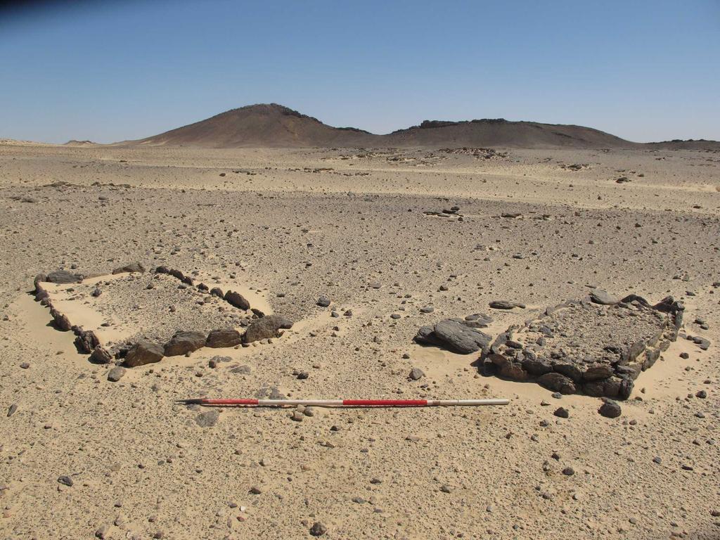
2 3. Realized work A- Survey (Fig. 1) The survey took place in the middle Wadi Abu Dom, starting from N 18 23'47'' E 32 04'20'' and reaching N 18 14'53'' E 32 12'26''. It was prepared already by intensive study of satellite images, including the inclusion of the visible data into our database, therefore we could head for several sites directly to evaluate these data. This year our intensive survey covered 24 km of the Wadi Abu Dom. At both banks we investigated the region depending on the topography up to 4 km into the hinterland. During this campaign, a total of 1222 sites were documented, containing altogether 2079 features. Complete lists of the features recorded and the finds collected are attached. General results: We observed a significant reduction of sites behind the bend of the Wadi Abu Dom at Umm Beida. Even bearing in mind that we did not include the category concentration of stones (manmade, but date and function unknown) any longer, there are much less sites in the northern part of the middle Wadi Abu Dom surveyed so far. There are differences in the distribution of the sites according to the topographical situation: in the hilly ground north of the Wadi the sites are (relatively) plentiful, in the region behind the ridges in the plains nerved with dykes there are only few sites. On the southern bank there are wide plains, again with only few sites. Last year we realized a difference in the type of wells (in the lower Wadi Abu Dom the wells consist of a large cylinder-shaped pit, mounted with stones, and a small deep hole; in the middle Wadi Abu Dom the wells are only holes in the ground). This coincides with the difference in the economic structure: horticulture in the small oases in the lower Wadi Abu Dom, pastoral subsistence in the middle Wadi Abu Dom. Maybe the difference in the distribution of the categories of our sites reflects also these differences in antiquity. The bed of at least some of the side khors seems to be quite young, since we observed the destruction of some tumuli by a channel of water. In one case a khor divides a Postmeroitic cemetery into two parts, again some of the tumuli heavily disturbed by the water. Maybe this is also the reason for the absence of older campsites, which are usually situated at the terraces of side khors. Cemeteries Although the number of cemeteries decreases, the size of the cemeteries, the number of tombs and the dimension of tombs increase. There are less and less box graves after the bend of the Wadi Abu Dom. Nearly all documented box graves of this year are laying within Postmeroitic cemeteries. On the other hand, we found Christian pottery (even of good quality) sometimes as surface find on several spots. We documented only few so-called Kerma-tumuli, situated at the ridges (Fig. 2). At none of these we found associated pottery. Within the areas of rocky dykes, several cleft burials are situated (Fig.
3 3). They have different sizes and irregular shape, since they lean against boulders. Most of them are disturbed and we found sherds of pottery nearby. At a plateau in the hinterland we found two big dome graves, both of them disturbed. Postmeroitic cemeteries were the most prominent feature in the otherwise quite meager archaeological region (Fig. 4). They are situated at the terraces near the wadi and at side khors. The graves itself are spread over a considerable area and the cemeteries include different types of superstructures. We hope that with future excavations we can detect the evolution of the types. Small numbers of box graves are also incorporated in these cemeteries (Fig. 5). The box graves are clustered in rows together at one spot, but sometimes even built on the Postmeroitic superstructures. The types of superstructures vary from very flat tumuli, surrounded with a band of quartz nuggets (Fig. 6) to quite huge tumuli (diameter up to 15 m and 1,5 m high) with a mounting of big black slabs (Fig. 7). Some of the tumuli seem to have a nose (triangular widening) to the east, some have a visible elevation of the superstructure at one side. Settlement structures There are some clusters of round huts visible on the surface, most of them at the pass between two rigdes or at plateaus in the hinterland. Several of these ridges contained cleft burials. The hut structures are usually quite simple (3-6 stonerings of 2-3m diameter, clustered together), only in few cases they seem to be more elaborated (Fig. 8 and 9). Since there were not found sherds we cannot suggest any date. We plan to excavate one of the hut structures within the next campaign to gain more information. We observed only few (in comparison to the lower Wadi Abu Dom) campsites at the terraces at side khors, most of them were quite recent. But the lack of older campsites can be the result of the variation of the water channels of the side khors (see above). Other sites Like in the region of el Tuweina, where we worked last year, also in the area surveyed this year we recognized several gravel beds (Fig. 10). Some of them are associated with stonerings. In many cases there were more than one of these gravel beds, sometimes situated at 90 to each other (Fig. 11). These gravel beds are often associated with Postmeroitic or Christian pottery. We did not excavate one of them yet, but the parallels already dug by Henryk Paner at the Forth Cataract and the difference in orientation of the single features let us suggest that these were also no graves. We plan to excavate some gravel beds exemplarily next season. Besides the gravel beds we found another type of platform, more or less regularly paved with slabs. Again, we cannot explain the function or date. Stonerings were abundant, but since they are mostly without finds one cannot define the date or function. They are situated in plains as well as at slopes of hills. Their size is 2-3m and they are constructed either of one single ring of stones or a rim of several stones. There are some very small stonerings within the rocky areas, which we address as deposit so far.
4 Near some of them we found some pottery. There was nearly no rock art in the area surveyed this year. This observation continues the trend we had already last year that with the advance deeper into the Wadi the rock art decreases. B- Architectural documentation of the ruin in Khor Shingawi (Fig. 12 and 13) About 15 km east from the Nile valley between Nuri and Merowe Dam, near the track leading into the Northern Bayuda, lies the ruin of an antique building in the wide plane of Wadi Shingawi. Geographical coordinates are N 18 33'35'', E 32 08'32''. Today, the site is situated more or less within the khor itself, with channels with some grass surrounding the building. One can suggest that it was not so in antiquity. Some small formations of rocks and single boulders are nearby; high mountains are in the background. It is a stone building of dry stone masonry, built of rough gneiss blocks. Measurements of plan were about 13 m by 43 m, remains of walls rise up to a maximum height of about 2 m above the flat surface of the Wadi. But due to accumulations of wind-blown sand, only about 50 cm to 80 cm of stone masonry are visible, also rooms are filled with the wind-blown sand. The building appears to have no particular name given by the local population; some consider it to be a grave. The mission of the W.A.D.I.-project spent about one week at the site, accomplishing an exact documentation of the visible architectural remains and conducting one sounding (Sond. B) in the courtyard and re-examining the sounding (Sond. A) done by the Polish expedition of G.A.M.E. in 2012, which was still open. Both soundings revealed that the building stands on a surface of hard compacted fluvial sediments, a kind of "gezira". Further result of the soundings was the proof of the existence of a coat of mud-plastering on the surface walls, which is completely eroded away on the visible parts of the masonry. In sounding B the existence of a hard compact mud/turab floor of the courtyard was ascertained. It rests on a layer of building construction debris. Furthermore a clearing of surface sand and stone debris was effected in some places, in order to gain more information on the architecture. All these intrusions, including the recent robber's pit, were refilled and the former surface was restored. The walls are built of dry stone masonry, the joins and hollow spaces are filled with pieces of stone partly mixed with clay, but not with mortar (in the same way like the structures in the Wadi Abu Dom). The used dry stones are flat pieces of gneiss. The quality of the construction is not very high (Fig. 14). The structure is oriented east-west with one L-shaped entrance at the north-eastern corner. The plan of the building clearly shows two sections (cf. Fig. 13). The western part, built of 1.00 m to 1.10 m thick walls, shows 5 rooms (17-21) of elongated plan, and one small room (22), which is inaccessible. The central room 8, 3.35m wide, was seemingly not roofed, as in the profiles of
5 sounding A no debris of any type of roofing could be observed. In the eastern wall of room 17 are two comparatively large windows (about 40 cm wide), overlooking the courtyard. More of these windows can be tentatively suggested for rooms 19, 20, 21, according to some features in the masonry of walls. The western building can be entered through one doorway only, from the courtyard. The function of the western building still remains unclear until further excavations. The eastern part of the building could be entered through a doorway (1.10m wide) on its northeastern corner (Fig. 15). It is the only doorway of access for the whole complex. It leads to corridor 1, which offers access to three apartment-like suites of rooms (2-3-4 and and 9-10). Walls are here 60 cm to 80 cm thick. For "apartment" some small windows (about 15 cm wide, 23 cm high) could be ascertained. In room 10, which fell victim to robbers at an earlier time, an abundance of mud-brick debris and mud soil can be observed, which obviously came to light through robber's activities (Fig. 16). In the other rooms in the vicinity there is just few debris of mud-brick visible. Bricks are about 20 cm wide, other measurements cannot be obtained. It remains an open question if the rooms were covered by mud-brick vaults, or if the stone walls were just extended in height by mud-brick and roofing was flat (wood-mats-mud-construction). Along the outer walls of the building there is comparatively little stone debris, although a good part could still be covered by the wind-blown sand. Room 11 is an extension of corridor 1 and offers a wide opening of access to the courtyard. Areas 14 and 16 can be interpreted as ramps leading up to the top of rooms 3 and 15, which are otherwise inaccessible. They could be silos or just the substructures of platforms. Room 12 is inaccessible - silo? The manner of construction and the character of rooms show a clear resemblance to the buildings of Umm Ruweim 1 and of Quweib. These could be dated to the Late Meroitic - Early Postmeroitic period. Nevertheless inspector Mohammed el Toum found in the near vicinity of the ruin a sherd of stamp-impressed Meroitic ware on the surface of the Wadi (Fig. 17). A first tentative interpretation of the building of Wadi Shingawi could be one as a seat of a local ruler. Today the main track from the asphalt through the Bayuda leads only several hundred meters north of the structure. During our work, every day 4-5 cars passed and the people asked if we dig for gold. We always explained not to do so, but there is the danger that there will be unauthorized digging there. There was already a big hole dug into the crossing of three walls in room 19 (Fig. 18). C- Pottery study Since our pottery specialist could not attend the last two seasons, Jana Helmbold-Doyè had to deal with the finds of three seasons together. Being for 4 weeks with us this year, she documented 2627 sherds, doing statistical recording and register them into the database. All the sherds of the campaigns are washed and photographed, several sherds are already drawn (Fig ).
6 To achieve the full documentation of all sherds, we need to export 135 samples, mostly with decoration, which are too time consuming to be drawn in the field season. The pottery covers the periods from Neolithic up to the Islamic time. The majority of the material is datable into the Postmeroitic period and we can observe close parallels to the pottery found this year in Zuma (see 5. Trips). On the other hand we found pottery of only local distribution which has no parallels in the Nile valley up to now. Moreover there are sherds of non-local origin, visible in specific components of the fabric. D- Conservation works Since the W.A.D.I.-project is in this stage only a survey project, we have no large scale conservation within our plans. But we realized that there are more and more tourists visiting even remote sites like Umm Ruweim, therefore we prepared the erection of a barrier between the track and the forecourt of the building (Fig. 21). The ghafir Mablul will be responsible for the construction of a blockade of wooden beams. In the second step next year, we will erect an information sign at the entrance of the structure to guide the tourists there and to provide them for stepping over the crumbly walls. Through the QSAP-funding we are engaged in the conservation project at Ghazali, where the plaster on the walls was cleaned and stabilized. E- Trips We did a two-days tour to visit the sites of El Kurru, Zuma, Banganarti, Kerma and Dokki Gel. Besides the introduction of these important sites to our students we had the opportunity to speak with the excavators Geoff Emberling, Rachael Dann, Mahmoud el Tayeb and Bogdan Zurawski to learn about their recent explorations. Especially at Zuma and Banganarti we had the possibility to compare the pottery of these sites with the ones we find in the Wadi Abu Dom. We want to thank our colleagues for their readiness to discuss their thoughts with us. On March 13th and 14th, the German ambassador Rolf Welberts and the Director General for Culture and Communication of the Federal Foreign Office, Germany, Dr. Hans-Ulrich Seidt, accompanied by his wife Maritta Seidt, visited the sites at Jebel Barkal, El Kurru, Nuri, Ghazali and Umm Ruweim. They were guided by Angelika Lohwasser and showed great interest in the antiquities of the Sudan. The Federal Foreign Office, Germany, funded the architectural documentation of Umm Ruweim in 2011 and El Tuweina in Proposal for future activities Our plans for the next year consist of two parts: on one hand we will continue the survey (it is proposed for two more years) with good preparation in remote sensing. In this part of the project (funded by the German Research Foundation, if the application for prolongation is positive) we will also include sondages at hut structures, gravel beds and campsites. The project part funded by QSAP will deal mainly with the excavation of Postmeroitic tumuli to develop knowledge of the
7 material culture and burial customs in this remote area. The link between both parts of the project will be the preparation of survey and excavation with remote sensing high resolution photographs. 5. Endangered sites Several of the tumuli we found in the Wadi Abu Dom were already disturbed, some of them quite recently (Fig. 22). Since we met repeatedly gold seeker in the Wadi last year, we assume that these people were responsible for the robber s work. Fortunately we did not meet any goldseeker in the Wadi this year, although there were some in Khor Shingawi. We hope that the rest of the tumuli are safe for the moment. We thought about installing a ghafir, but since there are only very few people living there, all of them lacking a car and the cemeteries are far from each other, it would not be possible for one person to guard them. 6. Final remarks We would like to thank Mr. Mohammed el Toum very much for all his indispensable help and smooth organization! He has acted as a good mediator to the people in the Wadi Abu Dom as well as an expert for organization and especially as a good friend to us! Karima, Angelika Lohwasser

 and 2014")

8 "Wadi Abu Dom Itinerary", 5th Season, Figures Fig. 1: Sites discovered in (blue) and 2014 (violet) Fig. 2: Tumulus on ridge Fig. 3: Cleft burial


9 Fig. 4: Postmeroitic cemetery Fig. 5: Box graves within a Postmeroitic cemetery


10 Fig. 6: Flat Postmeroitic tumulus Fig. 7 High Postmeroitic tumulus Fig. 8: Hut structure Fig. 9: Hut structure Fig. 10: Oval "gravel bed" Fig. 11: Two rectangular "gravel beds"


11 Fig. 12: Building in the Wadi Shingawi Fig. 13: Sketch plan of the building in Wadi Shingawi Fig. 14: Drystone masonry Fig. 15: Entrance a the northeastern corner


12 Fig. 16: Mudbrick in room 10 Fig. 17: Meroitic sherd near the building of Wadi Shingawi Fig. 18: Recent Robber's pit Fig. 19: Postmeroitic pottery


13 Fig. 20: Drawing of surface finds Fig. 21: Proposed protection of Umm Ruweim Fig. 22: Recently disturbed tumulus
Report of the Survey in the Wadi Abu Dom,
 Report of the Survey in the Wadi Abu Dom, 24.2.-16.3.2009 (funded by the Gerda Henkel-Foundation, Germany) Angelika Lohwasser Free University Berlin, Germany 1. Staff Gabriel, Prof. Dr. Baldur, Geographer,
Merowe Dam Archaeological Salvage Project (MDASP)
") Merowe Dam Archaeological Salvage Project (MDASP) Salah Mohamed Ahmed Introduction The idea of building a dam at the 4 th Cataract of the Nile dates to the period of the Anglo-Egyptian administration in
Merowe Dam Archaeological Salvage Project (MDASP) Salah Mohamed Ahmed Introduction The idea of building a dam at the 4 th Cataract of the Nile dates to the period of the Anglo-Egyptian administration in
IMTO Italian Mission to Oman University of Pisa 2011B PRELIMINARY REPORT (OCTOBER-DECEMBER 2011)
") IMTO Italian Mission to Oman University of Pisa 2011B PRELIMINARY REPORT (OCTOBER-DECEMBER 2011) The 2011B research campaign took place in the area around Salut from October, 19 th, to December, 16 th.
IMTO Italian Mission to Oman University of Pisa 2011B PRELIMINARY REPORT (OCTOBER-DECEMBER 2011) The 2011B research campaign took place in the area around Salut from October, 19 th, to December, 16 th.
The Italian Archaeological Mission in Sudan Ca Foscari University of Venice
 The Italian Archaeological Mission in Sudan Ca Foscari University of Venice Karima (Sudan) November-December 2012 The 2012 season of the Italian Archaeological Mission at Jebel Barkal was carried out between
Gebel Barkal (Sudan) No 1073
 No 1073") Gebel Barkal (Sudan) No 1073 1. BASIC DATA State Party : Republic of Sudan Name of property: Gebel Barkal and the Sites of the Napatan Region Location: Northern state, province of Meroe Date received:
Gebel Barkal (Sudan) No 1073 1. BASIC DATA State Party : Republic of Sudan Name of property: Gebel Barkal and the Sites of the Napatan Region Location: Northern state, province of Meroe Date received:
Jneneh in the Upper Wadi az-zarqa, in North Central Jordan, First Season 2011.
 Jneneh in the Upper Wadi az-zarqa, in North Central Jordan, First Season 2011. Khaled Douglas Jneneh is located in the north-western periphery of the city of Zarqa (grid ref. 250.88E 165.25N), in North
Lidar Imagery Reveals Maine's Land Surface in Unprecedented Detail
 Maine Geologic Facts and Localities December, 2011 Lidar Imagery Reveals Maine's Land Surface in Unprecedented Detail Text by Woodrow Thompson, Department of Agriculture, Conservation & Forestry 1 Introduction
THE EL-QITAK PROJECT. oi.uchicago.edu
 oi.uchicago.edu THE EL-QITAK PROJECT T H O M A S - L - M C C L E L L A N T he 1987 season at el-qitar ran from May 2 t o July 29th and marked the last major season of excavation there because the site
New Studies in the City of David The Excavations
 The 2013-2014 Excavations Israel Antiquities Authority The intensive archaeological work on the city of David hill during the period covered in this article has continued in previously excavated areas
Architectural Analysis in Western Palenque
 Architectural Analysis in Western Palenque James Eckhardt and Heather Hurst During the 1999 season of the Palenque Mapping Project the team mapped the western portion of the site of Palenque. This paper
B 1200: The Napatan palace and the Aspelta throne room.
 B 1200: The Napatan palace and the Aspelta throne room. The labyrinthine mud brick walls southwest of B 800 are the remains of the Napatan palace, designated "B 1200," at Jebel Barkal (fig. 1). Until now
A Survey in the Western Bayuda: The Wadi Abu Dom Itinerary Project (WA.D.L) 1
 1") Originalveröffentlichung in: Sudan & Nubia 16, 2012, S. 109-117 SUDAN & NUBIA A Survey in the Western Bayuda: The Wadi Abu Dom Itinerary Project (WA.D.L) 1 Angelika Lohwasser The region within the large
Originalveröffentlichung in: Sudan & Nubia 16, 2012, S. 109-117 SUDAN & NUBIA A Survey in the Western Bayuda: The Wadi Abu Dom Itinerary Project (WA.D.L) 1 Angelika Lohwasser The region within the large
archeological site LOS MILLARES
 archeological site LOS MILLARES Aerial view of the plain of Los Millares between the Rambla de Huéchar and the River Andarax The archaeological site of Los Millares is located in the township of Santa
As both one of the few substantially preserved pharaonic Egyptian. expulsion, the site of Deir el-ballas is of great archaeological and historic
 The 2017 Season at Deir el-ballas Peter Lacovara As both one of the few substantially preserved pharaonic Egyptian settlements as well as the forward capital for the Theban kings during the Hyksos expulsion,
TH E FIRST SEASON of investigations at the
 QUSEIR AL-QADIM Janet H. Johnson & Donald Whitcomb TH E FIRST SEASON of investigations at the ancient port of Quseir al-qadim on the Red Sea in Egypt took place in winter, 1978; the investigations were
Draft Report. 7. Excavations in the temenos gateway, Area (TG5) Author - D. A. Welsby Period 1-2. Period 1. Period 2. Derek A.
 Author - D. A. Welsby Period 1-2. Period 1. Period 2. Derek A.") 7. Excavations in the temenos gateway, Area (TG5) Derek A. Welsby When Griffith excavated the temples at Kawa in 1929-31, work followed by that of Macadam and Kirwan in the winter of 1935-6, the temenos
7. Excavations in the temenos gateway, Area (TG5) Derek A. Welsby When Griffith excavated the temples at Kawa in 1929-31, work followed by that of Macadam and Kirwan in the winter of 1935-6, the temenos
Antinoupolis. Ongoing Destruction. Pre-2006 crops. Modern cemetery covering. ancient cemetery. Antinoupolis, ancient city. North cemetery (ancient).
.") Antinoupolis Ongoing Destruction Ongoing Destruction North cemetery (ancient). Pre-2006 crops Modern cemetery covering ancient cemetery. Antinoupolis, ancient city. Modern village of el Sheikh Abada Nile
Antinoupolis Ongoing Destruction Ongoing Destruction North cemetery (ancient). Pre-2006 crops Modern cemetery covering ancient cemetery. Antinoupolis, ancient city. Modern village of el Sheikh Abada Nile
Tracks in the Bayuda desert. The project 'Wadi Abu Dom Itinerary' (W.A.D.I.)
") Originalveröffentlichung in: Frank Förster und Heiko Riemer (Hg.), Desert Road Archaeology in Ancient Egypt and Beyond (Africa Parehistorica 27), Köln 2013, S. 425-435 Angelika Lohwasser Tracks in the
Originalveröffentlichung in: Frank Förster und Heiko Riemer (Hg.), Desert Road Archaeology in Ancient Egypt and Beyond (Africa Parehistorica 27), Köln 2013, S. 425-435 Angelika Lohwasser Tracks in the
archeological site TÚTUGI
 archeological site TÚTUGI Aerial view of the sub-area Ia (Photo: Jose Julio Botía) Located in the vicinity of the urban centre of Galera, this necropolis, which dates back to the 5th century B.C., represents
aiton.new 1/4/04 3:48 AM Page 2
 aiton.new 1/4/04 3:48 AM Page 2 Below: An aerial view of area A of the excavations. A massive square building that appears to be a fortress was discovered in this area at the top of the tell. aiton.new
IKLAINA ARCHAEOLOGICAL PROJECT 2016 FIELD REPORT Michael B. Cosmopoulos
 IKLAINA ARCHAEOLOGICAL PROJECT 2016 FIELD REPORT Michael B. Cosmopoulos Introduction The overarching objective of the Iklaina project is to test existing hierarchical models of state formation in Greece
IKLAINA ARCHAEOLOGICAL PROJECT 2015 FIELD REPORT Michael B. Cosmopoulos
 IKLAINA ARCHAEOLOGICAL PROJECT 2015 FIELD REPORT Michael B. Cosmopoulos The 2015 season of the Iklaina project took place from June 1 to July 7. The project is conducted under the auspices of the Athens
The Greek-Swedish-Danish Excavations at Kastelli, Khania 2010 a short report
 The Greek-Swedish-Danish Excavations at Kastelli, Khania 2010 a short report During six weeks from 19 July to 27 August the Greek-Swedish-Danish Excavations continued work in the Ag. Aikaterini Square
By : K. Blouin, Th. Faucher, N. Hudson, M. Kenawi, A. Kirby, R. Mairs, G. Marchiori, M. Van Peene
 THMUIS, A NEW LAND IN THE EASTERN NILE DELTA FIRST CANADIAN MISSION AT THMUIS By : K. Blouin, Th. Faucher, N. Hudson, M. Kenawi, A. Kirby, R. Mairs, G. Marchiori, M. Van Peene The first Canadian Mission
FOUNDATIONS OF ARCHAEOLOGY A WALK IN VERNDITCH CHASE
 FOUNDATIONS OF ARCHAEOLOGY A WALK IN VERNDITCH CHASE 1. A Tale of two Long Barrows Long barrows were constructed as earthen or drystone mounds with flanking ditches and acted as funerary monuments during
SUDAN. The Kingdom of the Black Pharaohs. GUARANTEED DEPARTURES (min. 4 pax)
") SUDAN The Kingdom of the Black Pharaohs 10 days all accommodated tour + possible extension to Soleb GUARANTEED DEPARTURES (min. 4 pax) This tour shows all the major archaeological sites of the Northern
SUDAN The Kingdom of the Black Pharaohs 10 days all accommodated tour + possible extension to Soleb GUARANTEED DEPARTURES (min. 4 pax) This tour shows all the major archaeological sites of the Northern
SEVEN LAYER MONUMENTS OF THE EARLY OLD KINGDOM FORTHCOMMING
 SEVEN LAYER MONUMENTS OF THE EARLY OLD KINGDOM FORTHCOMMING إن شاء هللا FUNERARY PYRAMIDS Are: Stepped, Bent, Benben, or of True forms with some PROPERTIES namely: 1 - Correctness of SHAPE, 2 - STABILITY
Remote Sensing into the Study of Ancient Beiting City in North-Western China
 Dingwall, L., S. Exon, V. Gaffney, S. Laflin and M. van Leusen (eds.) 1999. Archaeology in the Age of the Internet. CAA97. Computer Applications and Quantitative Methods in Archaeology. Proceedings of
MIDDLE SCHOOL CURRICULUM TR AILING ICE AGE M YST ERI E S ICE AGE TREKKING
 MIDDLE SCHOOL CURRICULUM TR AILING ICE AGE M YST ERI E S ICE AGE TREKKING CONTENTS I. Enduring Knowledge... 3 II. Teacher Background... 3 III. Before Viewing this Video... 5 IV. Viewing Guide... 5 V. Discussion
In 2014 excavations at Gournia took place in the area of the palace, on the acropolis, and along the northern edge of the town (Fig. 1).
.") Gournia: 2014 Excavation In 2014 excavations at Gournia took place in the area of the palace, on the acropolis, and along the northern edge of the town (Fig. 1). In Room 18 of the palace, Room A, lined
Gournia: 2014 Excavation In 2014 excavations at Gournia took place in the area of the palace, on the acropolis, and along the northern edge of the town (Fig. 1). In Room 18 of the palace, Room A, lined
Following the initial soil strip archaeology is sprayed up prior to planning and excavation
 Barton Quarry & Archaeology Over the past half century quarries have been increasingly highlighted as important sources of information for geologists, palaeontologists and archaeologists, both through
Trench 91 revealed that the cobbled court extends further to the north.
 Report on the 2013 Gournia Excavations The 2013 excavations at Gournia were conducted June 17 July 26 under the aegis of the American School of Classical Studies at Athens and the supervision of the KD
Chapter 7 Geography and the Early Settlement of Egypt, Kush, and Canaan
 Chapter 7 Geography and the Early Settlement of Egypt, Kush, and Canaan How did geography affect early settlement in Egypt, Kush, and Canaan? Section 7.1 - Introduction RF/NASA//Corbis This satellite photograph
Sudanese Nubia 8 Days/7 Nights All Meals Included All Gratuities Included
 Sudanese Nubia 8 Days/7 Nights All Meals Included All Gratuities Included Featuring: Mogran Park. National Museum. Khalifa Museum. Old Dongola. Jebel Barkal. Kurru. Pyramids of Nuri. Gazali Valley and
CARLUNGIE EARTH HOUSE
 Property in Care (PIC) ID: PIC015 Designations: Scheduled Monument (SM90059) Taken into State care: 1953 (Guardianship) Last reviewed: 2004 HISTORIC ENVIRONMENT SCOTLAND STATEMENT OF SIGNIFICANCE CARLUNGIE
The Tel Burna Archaeological Project Report on the First Season of Excavation, 2010
 The Tel Burna Archaeological Project Report on the First Season of Excavation, 2010 By Itzick Shai and Joe Uziel Albright Institute for Archaeological Research Jerusalem, Israel April 2011 The site of
Archaeological Investigations Project South East Region SOUTHAMPTON 2/842 (C.80.C004) SU
 SU") SOUTHAMPTON City of Southampton 2/842 (C.80.C004) SU 4382 1336 125 BITTERNE ROAD WEST, SOUTHAMPTON Report on the Archaeological Evaluation Excavation at 125 Bitterne Road West, Southampton Russel, A. D
SOUTHAMPTON City of Southampton 2/842 (C.80.C004) SU 4382 1336 125 BITTERNE ROAD WEST, SOUTHAMPTON Report on the Archaeological Evaluation Excavation at 125 Bitterne Road West, Southampton Russel, A. D
TRAVEL AND EXPEDITION MINI GUIDE SUDAN THE KINGDOM OF THE BLACK PHARAOHS
 TRAVEL AND EXPEDITION SUDAN THE KINGDOM OF THE BLACK PHARAOHS 2 THE KINGDOM OF THE BLACK PHARAOS All accommodated tour through the most important Nubian archaeological sites with encounters with people
4. Bronze Age Ballybrowney, County Cork Eamonn Cotter
 4. Bronze Age Ballybrowney, County Cork Eamonn Cotter Illus. 1 Location map of the excavated features at Ballybrowney Lower (Archaeological Consultancy Services Ltd, based on the Ordnance Survey Ireland
Archaeology Internship in the Great Smoky Mountains National Park Summer 2010, Leila Donn
 Archaeology Internship in the Great Smoky Mountains National Park Summer 2010, Leila Donn This past summer I spent three months working as an archaeology intern in the Great Smoky Mountains National Park
Excavations in a Medieval Market Town: Mountsorrel, Leicestershire,
 Excavations in a Medieval Market Town: Mountsorrel, Leicestershire, by John Lucas Mountsorrel is situated 12 kms north of Leicester and forms a linear settlement straddling the A6, Leicester to Derby road.
We have compared the way a historian works to the way a detective
 2.8 Primary and Secondary Sources We have compared the way a historian works to the way a detective works. The main difference between detectives and historians is the evidence they work with. Detectives
The Semna South Project
 The Semna South Project Louis V. Zabkar For those who have never visited the area of southern Egypt and northern Sudan submerged by the waters of the new Assuan High Dam, and who perhaps find it difficult
SUDAN. The Kingdom of the Black Pharaohs
 SUDAN The Kingdom of the Black Pharaohs 10 days all accommodated tour + possible extension to Soleb Season 2015-2016 GUARANTEED DEPARTURES (min. 4 pax) This tour shows all the major archaeological sites
Jane C. Waldbaum Archaeological Field School Scholarship - Report.
 Jane C. Waldbaum Archaeological Field School Scholarship - Report. Eastern Boeotia Archaeological Project, 2017 Novella Nicchitta Figure 1 EBAP's team for 2017 This year I had the pleasure of participating
Chapter 7. Geography and the Early Settlement of Egypt, Kush, and Canaan
 Chapter 7 Geography and the Early Settlement of Egypt, Kush, and Canaan Chapter 7 Geography and the Early Settlement of Egypt, Kush, and Canaan How did geography affect early in Egypt Kush, and Canaan?
The Sanctuary of Athena Alea at Tegea: Recent Excavations in the Northern Area. Results and Problems
 The Sanctuary of Athena Alea at Tegea: Recent Excavations in the Northern Area. Results and Problems Chiara Tarditi The excavations in the northern area of the sanctuary of Athena Alea at Tegea, organized
IMTO Italian Mission to Oman. University of Pisa SUMHURAM. Preliminary Report. February March 2016 (SUM16A)
") IMTO Italian Mission to Oman University of Pisa SUMHURAM Preliminary Report February March 2016 (SUM16A) PRELIMINARY REPORT (SUM16A) February March 2016 The first IMTO s campaign of 2016 (SUM16A), under
IMTO Italian Mission to Oman University of Pisa SUMHURAM Preliminary Report February March 2016 (SUM16A) PRELIMINARY REPORT (SUM16A) February March 2016 The first IMTO s campaign of 2016 (SUM16A), under
ROUKEN GLEN: BANDSTAND 2015 DATA STRUCTURE REPORT
 ROUKEN GLEN: BANDSTAND 2015 DATA STRUCTURE REPORT Author (s) Ian Hill Editors Report Date June 2015 Working Partners Funders Phil Richardson East Renfrewshire Council East Renfrewshire Council, Heritage
The City-Wall of Nineveh
 The City of Nineveh Nineveh has a very long history, with finds dating already back at fifth millennium. As part of the Assyrian empire, the city served as a regional center during the Middle and Early
The Yingtianmen Gate-site of the Sui and Tang Eastern Capital in Luoyang City
 Nandajie The Yingtianmen Gate-site of the Sui and Tang Eastern Capital in Luoyang City Tang Luoyang City-site Archaeological Team, Institute of Archaeology, Chinese Academy of Social Sciences Key words:
Documentation of Mosaic Tangible Heritage in Jordan Jarash Governorate
 Documentation of Mosaic Tangible Heritage in Jordan Jarash Governorate Catreena Hamarneh, Abdel Majeed Mjalli, Mohamed al-balawneh Introduction In the year 2005 a project was launched to build up a data
Ground Penetrating Radar Survey Report:
 Ground Penetrating Radar Survey Report: German Hospice in Jerusalem, Israel Data Acquired June 19, 2003 Report compiled August 26, 2003 Survey and Report Published by Mnemotrix Systems, Inc. Copyright
IKLAINA ARCHAEOLOGICAL PROJECT 2012 FIELD REPORT
 IKLAINA ARCHAEOLOGICAL PROJECT 2012 FIELD REPORT Michael B. Cosmopoulos The sixth season of the Iklaina Archaeological Project was conducted for six weeks in June and July 2012. Τhe project is conducted
GLACIER STUDIES OF THE McCALL GLACIER, ALASKA
 GLACIER STUDIES OF THE McCALL GLACIER, ALASKA T John E. Sater* HE McCall Glacier is a long thin body of ice shaped roughly like a crescent. Its overall length is approximately 8 km. and its average width
Ancient Greek Buildings/ Fortifications. Matthew Jackson
 Ancient Greek Buildings/ Fortifications Matthew Jackson What is a fortification? -The combination of terrain and available materials to form a means of defense against potential attackers -Represent the
How the Nile River Led to Civilization in Ancient Egypt
 How the Nile River Led to Civilization in Ancient Egypt By USHistory.org, adapted by Newsela staff on 03.07.17 Word Count 786 Level 950L TOP: This photo, taken around 1915, shows the flooding of the Nile
Ancient Kingdoms of Sudan. 12 Days
 Ancient Kingdoms of Sudan 12 Days Ancient Kingdoms of Sudan On this extraordinary adventure through rarely visited Sudan, journey across breathtaking deserts, ancient pyramids, and buzzing markets. Cruise
Typical avalanche problems
 Typical avalanche problems The European Avalanche Warning Services (EAWS) describes five typical avalanche problems or situations as they occur in avalanche terrain. The Utah Avalanche Center (UAC) has
Labraunda Preliminary report
 Labraunda 2012. Preliminary report The excavations at Labraunda this year were very successful and lasted for eight weeks. Our main new discovery is obviously the gold coin from Philip II discovered in
A Near Eastern Megalithic Monument in Context
 Special Volume 3 (2012), pp. 143 147 Mike Freikman A Near Eastern Megalithic Monument in Context in Wiebke Bebermeier Robert Hebenstreit Elke Kaiser Jan Krause (eds.), Landscape Archaeology. Proceedings
CULTURAL HERITAGE RESOURCES IMPACT ASSESSMENT ON MALOKONG HILL
 CULTURAL HERITAGE RESOURCES IMPACT ASSESSMENT ON MALOKONG HILL AFRICAN HERITAGE CONSULTANTS CC 2001/077745/23 Tel/fax: (012) 567 6046 Cell: 082 498 0673 E-mail: udo.heritage@absamail.co.za DR. UDO S KÜSEL
Fort Ticonderoga Carillon Battlefield Walking Trail Guide
 Fort Ticonderoga Carillon Battlefield Walking Trail Guide Copyright Fort Ticonderoga. Photo Credit Carl Heilman II Length: Approximately 1¾ mile Welcome to Fort Ticonderoga s Walking Trail Blue markers
Exploration and Analysis on the Historical Remains of Wooden. Fence in Koguryo Mountain City
 Original Paper World Journal of Social Science Research ISSN 2375-9747 (Print) ISSN 2332-5534 (Online) Vol. 5, No. 1, 2018 www.scholink.org/ojs/index.php/wjssr Exploration and Analysis on the Historical
Chapter 7: The Geography and Settlement of Egypt, Kush, and Canaan
 Chapter 7: The Geography and Settlement of Egypt, Kush, and Canaan Learning Target: I can explain how geography affected early settlement in Egypt, Kush, and Canaan. Ancient Egypt and the Middle East Can
Understanding user expectations And planning for long term sustainability 1
 Understanding user expectations And planning for long term sustainability 1 What is a natural surface trail? It can be as simple has a mineral soil, mulched or graveled pathway, or as developed as elevated
New Archaeological Discoveries South of the Hanyuan Hall at the Daming Palace of Tang Dynasty
 New Archaeological Discoveries South of the Hanyuan Hall at the Daming Palace of Tang Dynasty The Xi an Tang City Archaeology Team, IA, CASS Key words: Imperial Palaces-China-Tang Dynasty Hanyuan Hall
Srikumar M. Menon Faculty of Architecture, Manipal Institute of Technology, Manipal
 NEW DISCOVERIES OF STONE ALIGNMENT AND MEGALITHIC BURIALS IN KARNATAKA Srikumar M. Menon Faculty of Architecture, Manipal Institute of Technology, Manipal 576104 srikumar.menon@gmail.com Mayank N. Vahia
-abstract- Carmen Olguţa Rogobete. Key words: domestic architecture, Greek colonies, above-ground houses, dugouts, semidugouts,
 The Domestic Architecture in the Greek Colonies on the Western and Northern Shore of the Black Sea (end of the 7 th Century-end of the 1 st Century BC) -abstract- Carmen Olguţa Rogobete Key words: domestic
THE DRY MOAT SURROUNDING THE STEP PYRAMID COMPLEX AT SAQQARA
 THE DRY MOAT SURROUNDING THE STEP PYRAMID COMPLEX AT SAQQARA THE GREAT RECTANGULAR MONUMENTS OF MIDDLE SAQQARA THE STEP PYRAMID COMPLEX WAS BUILT BY IMHOTEP AND WAS RESTORED BY JEAN-PHILIPPE LAUER THE
SUDAN 2018 The Kingdom of The Black Pharaohs (12 days) Includes Kerma and Soleb
 Includes Kerma and Soleb") 930 Irwin Street, Suite 222, San Rafael, CA 94901 Phone: 415-381-5861 888-367-6147 inquire@originalworld.com www.originalworld.com CST Permit #2057026-40 SUDAN 2018 The Kingdom of The Black Pharaohs (12
930 Irwin Street, Suite 222, San Rafael, CA 94901 Phone: 415-381-5861 888-367-6147 inquire@originalworld.com www.originalworld.com CST Permit #2057026-40 SUDAN 2018 The Kingdom of The Black Pharaohs (12
ARDESTIE EARTH HOUSE HISTORIC ENVIRONMENT SCOTLAND STATEMENT OF SIGNIFICANCE. Property in Care no: 24
 Property in Care no: 24 Designations: Scheduled Monument (SM90021) Taken into State care: 1953 (Guardianship) Last reviewed: 2004 HISTORIC ENVIRONMENT SCOTLAND STATEMENT OF SIGNIFICANCE ARDESTIE EARTH
Restoration of the historic site for public use in Takatsuki City
 Restoration of the historic site for public use in Takatsuki City The Imashirozuka Museum Restoration of the Imashirozuka Burial Mound national historic site for public use Introduction Upon completion
GPR prospection at Borgholm castle, Öland, Sweden
 ArcheoSciences Revue d'archéométrie 33 (suppl.) 2009 Mémoire du sol, espace des hommes GPR prospection at Borgholm castle, Öland, Sweden Immo Trinks, Pär Karlsson, Magnus Stibéus, Clas Ternström and Alois
Lordenshaw. What are cup & ring marks?
 Lordenshaw Lordenshaw hill has one of the largest clusters of ancient cup and ring marked stones in the UK. We ve chosen four interesting spots we d like to share with you. What are cup & ring marks? The
Excavation in Area G: squares m/14-15, new building BG1 (trench supervisor: Cleto Carbonara)
") Excavation in Area G: squares m/14-15, new building BG1 (trench supervisor: Cleto Carbonara) The excavation in the Area G started in the 1 st October has two main purposes: To understand the real extension
Excavation in Area G: squares m/14-15, new building BG1 (trench supervisor: Cleto Carbonara) The excavation in the Area G started in the 1 st October has two main purposes: To understand the real extension
A New Fragment of Proto-Aeolic Capital from Jerusalem
 TEL AVIV Vol. 42, 2015, 67 71 A New Fragment of Proto-Aeolic Capital from Jerusalem Doron Ben-Ami and Yana Tchekhanovets Israel Antiquities Authority The article deals with a fragment of a proto-aeolic
III. THE EARLY HELLADIC POTTERY FROM THE MASTOS IN THE BERBATI VALLEY, ARGOLID
 III. THE EARLY HELLADIC POTTERY FROM THE MASTOS IN THE BERBATI VALLEY, ARGOLID by JEANNETTE FORSÉN The Swedish investigations of the hillock Mastos in the western part of the Berbati valley, ca. 3 km south
Glacial Origins and Features of Long Island
 Glacial Origins and Features of Long Island Interior Coastal Plain Continental Shelf Long Island s Geology 0 Ma Phanerozoic 540 Ma Proterozoic 2500 Ma Archean 3800 Ma Hadean 4600 Ma C M P Geologic Time
INTERPRETING TOPOGRAPHIC MAPS (MODIFIED FOR ADEED)
") INTERPRETING TOPOGRAPHIC MAPS (MODIFIED FOR ADEED) Science Concept: Topographic maps give information about the forces that shape the features of Earth. Objectives: The student will: identify land features
INTERPRETING TOPOGRAPHIC MAPS (MODIFIED FOR ADEED) Science Concept: Topographic maps give information about the forces that shape the features of Earth. Objectives: The student will: identify land features
A day with Macedonian Archaeology Arheo Park Brazda
 A day with Macedonian Archaeology Arheo Park Brazda The archeological site Gradiste Brazda is situated nearly 15 km north of Skopje, on a humble hill that rises over the village of Brazda. According to
Gorse Stacks, Bus Interchange Excavations Interim Note-01
 Gorse Stacks, Bus Interchange Excavations 2015 Prepared for: Cheshire West & Chester Council Interim Note-01 1 Introduction & Summary Background Since c. 2000 investigations associated with redevelopment
Frankfurter elektronische Rundschau zur Altertumskunde 2 (2006) Hazar Lake Sunken City. Çiğdem Özkan-Aygün
 Hazar Lake Sunken City. Çiğdem Özkan-Aygün") Hazar Lake Sunken City Çiğdem Özkan-Aygün Abstract In October 2005, an underwater survey was undertaken at Lake Hazar, where a sunken walled settlement was discovered which might confirm reports by travelers
Hazar Lake Sunken City Çiğdem Özkan-Aygün Abstract In October 2005, an underwater survey was undertaken at Lake Hazar, where a sunken walled settlement was discovered which might confirm reports by travelers
First announcement concerning the results of the 2005 exploratory season at Tel Kabri
 First announcement concerning the results of the 2005 exploratory season at Tel Kabri Assaf Yasur-Landau Tel Aviv University (assafy@post.tau.ac.il) Eric H. Cline The George Washington University (ehcline@gwu.edu)
The early Ramesside occupants of tomb MIDAN.05
 The early Ramesside occupants of tomb MIDAN.05 Marilina Betrò and Gianluca Miniaci continue the exploration of tomb MIDAN.05 in the Theban Necropolis. Discovered in 2004 by the archaeological expedition
RESEARCH BULLETIN. Parks Canada. Parcs Canada. Cette publication est disponible en français.
 RESEARCH BULLETIN No. 201 August 1983 Scratching the Surface-Three Years of Archaeological Investigation in Wood Buffalo National Park, Alberta/N.W.T.-Preliminary Summary Report Marc G. Stevenson Archaeology,
Archaeological Monitoring at Ham Farm, Ham Road, Faversham, Kent
 Archaeological Monitoring at Ham Farm, Ham Road, Faversham, Kent NGR: 601750.0mE 162695.0mN Site Code HAM/WB/12 Report for A.J. Bray SWAT ARCHAEOLOGY Swale and Thames Archaeological Survey Company The
Tomb raiders: Eight ancient mummies found near Luxor, Egypt
 Tomb raiders: Eight ancient mummies found near Luxor, Egypt By Agence France-Presse, adapted by Newsela staff on 04.24.17 Word Count 646 Level 1180L An expert inspects a sarcophagus found with mummies
A FIELDWALKING PROJECT AT HOLLINGBURY, BRIGHTON. by JOHN FUNNELL
 Introduction A FIELDWALKING PROJECT AT HOLLINGBURY, BRIGHTON by JOHN FUNNELL Members of the Brighton and Hove Archaeological Society walked the field at Hollingbury during the months of December 1991 and
Enhanced Emergency Shelter Kit (EESK)
") Finalized on 9 th of August 2017 Enhanced Emergency Shelter Kit (EESK) Introduction The enhanced emergency shelter kit was designed to cover the surface area of 15 m 2 with volume of 37.5 m 3. The size
Finalized on 9 th of August 2017 Enhanced Emergency Shelter Kit (EESK) Introduction The enhanced emergency shelter kit was designed to cover the surface area of 15 m 2 with volume of 37.5 m 3. The size
The Coach House, Mill Lane, Cookham, Berkshire
 The Coach House, Mill Lane, Cookham, Berkshire An Archaeological Watching Brief For Ms Sophia Butler by Stephen Hammond Thames Valley Archaeological Services Ltd Site Code CMC 03/104 October 2003 Summary
Mausoleum of Khoja Ahmed Yasawi (Kazakhstan) (C 1103)
 (C 1103)") Mausoleum of Khoja Ahmed Yasawi (Kazakhstan) (C 1103) The report on the state of conservation of mausoleum of Khoja Ahmed Yasawi according to the decision 38 COM 7В.16 Almaty 2016 CONTENTS 1. History (I)
Mausoleum of Khoja Ahmed Yasawi (Kazakhstan) (C 1103) The report on the state of conservation of mausoleum of Khoja Ahmed Yasawi according to the decision 38 COM 7В.16 Almaty 2016 CONTENTS 1. History (I)
ANNUAL REPORT: ANCIENT METHONE ARCHAEOLOGICAL PROJECT 2014 FIELD SCHOOL
 ANNUAL REPORT: ANCIENT METHONE ARCHAEOLOGICAL PROJECT 2014 FIELD SCHOOL Director(s): Co- Director(s): Professor Sarah Morris, Cotsen Institute of Archaeology, UCLA John K. Papadopoulos, Cotsen Institute
IAS Prelims Exam: Ancient History NCERT Questions: The Harappan Civilisation Set II
 IAS Prelims Exam: Ancient History NCERT Questions: The Harappan Civilisation Set II Questions asked from Ancient Indian History section in IAS Prelims Exam are quite easy but the candidates need to memorise
APPENDIX E LYONS PARK ESTATES DETAILED COMMUNITY ASSESSMENT RESULTS
 # Houses: 65 APPENDIX E LYONS PARK ESTATES DETAILED COMMUNITY ASSESSMENT RESULTS Overall Risk Assessment: High Description: Lyons Park Estates is located on the foothills south of the town of Lyons on
MONTEVECCHIA Pyramid Hills.. Summary 9 pages
 Gabriela Lukacs, Mag.rer.soc.oec., graduate Vienna university Post graduate art +history university Siena, Italy Participant of the excavations in Visoko, Bosnia since 2006 Grinzinger Allee 15, 1190 Wien,
Ancient Egypt and the Near East
 *O*»f ' i ft Ancient Egypt and the Near East Chapter 7 Chapter 8 Chapter 9 Geography and the Early Settlement of Egypt, Kush, and Canaan The Ancient Egyptian P h a r a o h s Daily Life in Ancient Egypt
47I THE LAS ANIMAS GLACIER.
 THE LAS ANIMAS GLACIER. ONE of the largest of the extinct glaciers of the Rocky Mountains was that which occupied the valley of the Las Animas river. This stream originates in the San Juan mountains in
The importance of Jerusalem for the study of Near Eastern history and. archaeology and for the study of the Biblical text (both old and new) cannot
 cannot") Setting the Clock in the City of David: Establishing a Radiocarbon Chronology for Jerusalem's Archaeology in Proto-historical and Historical Times Yuval Gadot, Johana Regev, Helena Roth and Elissabeta
Setting the Clock in the City of David: Establishing a Radiocarbon Chronology for Jerusalem's Archaeology in Proto-historical and Historical Times Yuval Gadot, Johana Regev, Helena Roth and Elissabeta
Amarna Workers Village
 Amarna Workers Village The Egyptian city of Amarna was the pet building project of the pharaoh Akhenaten, who oversaw construction of his new capital between 1346 and 1341 BCE. The city was largely abandoned