Height System Unificationand GOCE. Reiner Rummel, Michael Sideris, Phil Woodworth
|
|
|
- Ezra Blair
- 5 years ago
- Views:
Transcription
1 Height System Unificationand GOCE Reiner Rummel, Michael Sideris, Phil Woodworth 14th Canadian Geoid Workshop, Banff/Alberta, June 5, 2012
 mission goals: gravity with 1 ppm (1 mgal) accuracy")
 polar data gaps circular altitude 265km!")
2 GOCE basic facts Gravity andsteady stateoceancirculationexplorer launched on March 17, 2009 (now 2½ years in orbit) first mission of ESA s Living Planet programme (followed by SMOS and CRYOSAT) mission goals: gravity with 1 ppm (1 mgal) accuracy geoid with 1 to 2 cm accuracy spatial resolution 100km (equivalent to degree/order = 200 in spherical harmonics) orbit characteristics inclination 96.5 (sun synchronous) polar data gaps circular altitude 265km! mission duration: medium monthsdata processed


3 GOCE gravity gradiometry measurement principle: acceleration differences GOCE: firstgravitationalgradiometer

4 GOCE gravity gradiometry 2 2 Vxx Vxy Vxz ω y ωz ωω x y ωxωz 0 ωz ωy 2 2 Vyx Vyy Vyz + ωω y x ωz ωx ωω y z + ωz 0 ωx 2 2 Vzx Vzy V zz ωω z x ωzωy ωx ω y ωy ωx 0 Y GRF Y A A Y 2 6 O 6 X X O2 6 2 Z 6 6 Z 2 2 A Y X X A 4 O4 Y 1 O1 X 1 Z 1 1 O 4 GRF GRF Z 4 4 A Y A Y 5 3 O O3 X 5 X 5 3 Z 5 5 Z 3 3 Z GRF Basic facts: 1.Measurementstaken in a rotatingframe 2. Eachaccelerometer withtwo ultra precise andone robust axis 3. Noise is white onlyinside themeasurement band (MB) from 5mHz to 0.1Hz (belowincreaseas 1/f) skew symmetric

5 GOCEsensorsystem ion thrusters xenon tank nitrogen tank power supply star sensor gravitational gradiometer GPS receiver source: ESA ion thruster control unit magneto torquers control unit an orbiting gravitational laboratory high performance of all sensors very different from typical remote sensing satellites
6 GOCE gravitymodels Global GOCE Gravity Field Models Model Data D/O Characteristics DIR1 2 Months 240 Direct Approach: Prior model (combined) plus GOCE orbits & gradiometry DIR2 6 Months 240 Direct Approach: Prior model (GRACE-only) plus GOCE orbits & gradiometry DIR3 1 Year 240 Direct Approach: Prior model (GRACE-only normals) plus GOCE gradiometry TIM1 2 Months 224 Time-wise Approach: Pure GOCE (kin. orbits & gradiometry) TIM2 6 Months 250 Time-wise Approach: Pure GOCE (kin. orbits & gradiometry) TIM3 1 Year 250 Time-wise Approach: Pure GOCE (kin. orbits & gradiometry) SPW1 2 Months 210 Space-wise Approach: GRACE low d/o plus GOCE gradiometry SPW2 6 Months 240 Space-wise Approach: Pure GOCE (kin. Orbits &gradiometry) GOCO01s 2 Months 224 Time wiseand ITG Grace2010s (d/o 180) GOCO02s 8 Months 250 Time wiseand ITG Grace2010s (d/o 180) + CHAMP+SLR


7 GOCE reprocessing Combinedprocessingof all threestartrackers Optimizedattitudedetermination Optimized angular rate reconstruction Interpolation ofcalibrationmatrices Brockmann, Schuh, Krasbutter, 2012 Technical Note
8 GOCE reprocessing GPS leveling vs. GOCE & EGM2008 Canada USA Th Gruber, 2012
9 Status of GOCE Launch in March 2009; sciencedatasince November 2009 GOCE combines (fouraccurate) gradiometercomponentsv xx, V yy, V zz andv xz andorbittrackingby GPS Itsstrengthareprimarilytheshorterspatialscales, say> d/o 80 Approximatelyonefullyearofdataprocessedby HPF Currently level 1b re processing (combinationof 3 STRs, improved angular rate reconstruction, interpolationofcalibrationmatrices) mainimprovementsexpectedatlongspatialscales Commissionerrordecreaseswiththesqrtoffullorbitcycles (each 31 days)
10 GOCE and GRACE 10-6 SLR GRACE GOCE Mean Signal per Degree / Degree Error Median Mean Signal QL GOCE Model Mean Signal Kaula Rule ErrorMedianQLGOCEModel Error Median EIGEN-5S Error Median EIGEN-5C temporal variations GRACE GOCE Degree 400km 200km 100km degreevariances (median) ofsignalandnoise

11 GOCE and GRACE Yi W, 2011 Contribution anylysis of a GOCE GRACE combination

, problematicregions (red)")
12 GOCE versus EGM in cm RMS geoiddifferencesbetween EGM2008 and GOCE release 3 wellsurveyedregions (black), problematicregions (red) andantarctica (green)
13 GOCE versus EGM2008 Yi & Rummel, 2012 Geoid differences GOGRA vs. EGM08

14 GOCE versus EGM2008 EGM arc minute areameangravityanomalies datasources Pavlis et al., 2012)

15 GOCE overview GOCE special issue of Journal of Geodesy Volume 85, no.11, 2011
 tide gauges altimetry topography deformations laboratory mean ocean circulation bedrock topography levelled heights post glacial rebound unified height system mean ocean circulation")
16 GOCE scienceandapplication point of departure solid earth ocean ice geodesy sea level gravity anomalies seismic tomograpy geoid gravity anomalies geoid ocean altimetry ice topography positioning (GPS) tide gauges altimetry topography deformations laboratory mean ocean circulation bedrock topography levelled heights post glacial rebound unified height system mean ocean circulation anomalous density structure constraints on mass & heat transport mass balance of ice sheets gravity anomalies ice mass balance orbits unified height systems INS orbits Granada, 1999
17 GOCE andheightsystemunification ESA s Support Top Science Element (STSE) An elementofthe Earth Observation Envelope Programme 3 Theme 1: Height System Unificationwith GOCE (STSE HSU) Team: IAPG, Technical University Munich (coordination) University of Calgary BKG, Frankfurt/Main NOC Liverpool andconsultants
18 GOCE andheightsystemunification The nineitemsofthisstudy: 1. State-of-the-art in heightsystemsandtheirunification 2. Quantificationofknowndifferences 3. Review, evaluationandimprovementofmethodology 4. Attemptof global height (andtidegauge) unification 5. Selectionoftwotestregions effectof GOCE 6. Effectofunification on localgravityandtopographicheights 7. Geophysicalinterpretation: dynamicoceantopography, currents, 8. Involvementoflocal/ national authorities 9. Roadmap forfutureworkusing GOCE: worldheightsystem andverticaldatum


19 GOCE andheightsystemunification Perspective With GOCE gravity models a significant improvement of the global geoid can be reached. Models based on 1 year of data reach a global geoid error of 4.6 cm at 100 km resolution. With a successful extended mission of GOCE this can be further improved to better than 2.9 cm after *) from: R. Pail, IAPG
20 Structureandstatusof STSE GOCE HSU WP200: Preliminary Analysis Existing methods (210) Review ( ) VC propagation (220) GBVP approach (230) Optimal combination (280) Regional studies: North America North Atlantic Europe/Germany WP500: Impact Assessment Quality analysis of global simulation (540) GOCE regional impact assessment ( , 550) WP100: Requirements Consolidation WP400: Development & Validation Global unification simulator and error propagation (410) Regional unification and error assessment ( ) WP300: Data Collection & Promo. Web page (310, 320) Data collection ( ) Promotion (350) WP600: Scientific Roadmap Geodetic application (620) Roadmap regional unification and application (610, 630, 640) Roadmap global unification GGOS, IAG, WHS (650)
21 GOCE andheightsystemunification Vertical Reference Frame Definition The realization of a system for elevations that supports physical and geometric heights globally with ppb relative accuracy Vertical Datum A level, zero-height surface with a conventional value W o A W o value does not imply knowledge of the level surface itself Realization and Unification Data: GNSS/SLR, geodetic & ocean leveling, TGs, altimetry, gravity, GGMs Zero-tide system (BVP solution requirement) Convert C to H or H*, or vice versa Select/determine global W o value Determine local W oj values and connect W oj to W o C P = W o W P = dw = gdh P P o P P o
22 GOCE andheightsystemunification Vertical Reference Frame W o can be obtained from, e.g., ellipsoidal parameters (W o = U o ), or computed/assigned to a tide gauge or from a GGM and/or altimetry and/or MSL fit or from the solution of a (generalized) geodetic BVP W P can be obtained either from the BVP solution for T P W P = U P + T P or from levelling plus gravity (given W o ) C P = W o W P = gδn or from GNSS/SLRand geodetic/ocean levelling T P = gn P =g(h P H P ) Consistent use of standards, theory and data is essential

23 GOCE andheightsystemunification Solution of the height datum problem North America North Atlantic Europe
24 GOCE andheightsystemunification The GBVP approach Global offset No δ ( GM ) ΔWo ( h H j ) N = + Rγ γ C γ jo Geoid from GPS/levelling Geoid from solution of GBVP Regional offset Njo Gravimetric geoid with biased gravity anomalies R 2 N = S( ψ ) Δg j + C jo dω, 4πγ Ω R g Δg j = g H j γ h
25 GOCE andheightsystemunification GOCEgeoid: Limited resolution Omission error 30 cm Commission error 1 2 cm The GBVP approach N GOCE = GM Rγ L max l P (cosθ )( ΔC cos mλ +ΔS lm l= 2 m= 0 lm lm sin mλ) GOCE N = N + N res N res = R res res S ( ψ ) Δg j dω + 4πγ Ω 1 S 2πγ Ω res ( ψ ) C jo dω Biased residual geoid Indirect bias term
26 GOCE andheightsystemunification functionalpart adjustmentmodel stochasticpart land topography 8000m A O c C B H c h(c) H b h(b) N(C) N(B) O b mean dynamic ocean topography (MDT) ±1 to 2m O a h(a) H a N(A) geoid reference ellipsoid


27 GOCE andheightsystemunification Variance covariance propagation for GOCE Comparable precision of h, H, N, or ζ and proper stochastic models GOCEVCM, d/o 250 for the first orders m=0,1,2,3 HSU simulator for error analysis and impact assessment GOCO2s up to d/o 200: Geoid height error Full Error VCM m block approximation


28 GOCE andheightsystemunification Geometric and Gravimetric Coordinate System consistency The N1 term in the geoid height should be added if GOCE is not geo localized in a geocentric reference frame Center of mass in a geocentric reference system


29 GOCE andheightsystemunification Evaluation of the Indirect Bias Term All offsets are computed with respect to the global level surface defined by 2 2 W o = m / s

30 GOCE andheightsystemunification Evaluation of the Indirect Bias Term Stokes kernel
31 GOCE andheightsystemunification Evaluation of the Indirect Bias Term Truncated Stokes kernel: Lmax= 150

32 GOCE andheightsystemunification Evaluation of the Indirect Bias Term

33 GOCE andheightsystemunification Effect of the Omission Error Mean differences between the regional GPS/levelling geoid heights and GOCEgeoid heights computed by means of TIM_R3, d/o=200
")
34 GOCE andheightsystemunification Effect of the Omission Error North America: Datum offsets computed with EGM2008 truncated to different d/o (of the available satellite only and combined global gravity models)

35 GOCE andheightsystemunification Effect of the Omission Error A simulation study: minimum size of the averaging area with GPS/levelling stations for which the mean omission error is few centimeters neglect res the N term.
 (3) Larger differences between observed and simulated mean omission error might indicate systematic")
36 GOCE andheightsystemunification Effect of the Omission Error Average Area Point (1) The mean omission error is at a cm level (2) In all cases, the difference between area and point averages is below 2cm (exception: Switzerland) (3) Larger differences between observed and simulated mean omission error might indicate systematic effects
37 GOCE andheightsystemunification Height Unification Using Ocean Information NOCL Objectives: (1)Collect tide gauge, GPS, altimeter, ocean model and geoid information so as to compare MSL differences (adjusted by the models) to geoid differences over a given epoch at and near the coast (in the case of tide gauges and altimetry respectively) (2)Thereby both validate the new geoid models, and obtain confidence in the use of ocean models to relate MSL (and so datums) in one country to that in another. PSMSLRLR Stations (> 40 Years of Data)
38 MSL above National Datums North Atlantic Nova Scotia

39
40 MSL above National Datums North Pacific USA MSL approximately 1 metre above datum on the Pacific coast
41 MSL minus Geoid (GOCO03Sp) N America Atlantic Outlier Reedy Point
42 MSL minus Geoid (Extended Model) N America Atlantic Outliers Reedy Point and Portland (maybe Fernandina Beach)
43

44 GOCE andheightsystemunification Project Website
45 GOCE andheightsystemunification Outlook (1) Development of global height system unification simulator and error propagation (2) Implementation of the least squares adjustment model (3) Regional unification of height systems in Europe and North America (4) Connecting Europe and North America using (i) the GBVP approach and (ii) using ocean information (5) Quality analysis and interpretation of height unification results with the GBVP approach (6) Assessment of improvement in height unification with and without the GOCEgeoid (7) Assessment of improvement in consistency between geodetic and oceanographic insights into spatial variation in sea level on regional and basin scales. (8) Developing a roadmap for regional and global height system unification
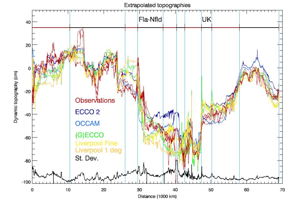
Along track profiles of dynamic ocean topography as an essential tool for the improvement of Brazilian heights
 Along track profiles of dynamic ocean topography as an essential tool for the improvement of Brazilian heights Roberto T Luz Wolfgang Bosch Sílvio R C Freitas Bernhard Heck Roman Savcenko Regiane Dalazoana
Who am I? National Geodetic Survey s Great Lakes Region Geodetic Advisor. John Ellingson Cell:
 Who am I? National Geodetic Survey s Great Lakes Region Geodetic Advisor John Ellingson john.ellingson@noaa.gov Cell: 202-306-6904 Today s Discussion 1st Topic ----- New Datums Coming in 2022 2nd Topic
Notes on the History of the National Geodetic Vertical Datum 1929 and the North American Vertical Datum 1988 in Alaska, U.S.A. 1
 1 1 2 3 4 5 6 7 8 9 10 11 12 13 14 15 16 17 18 19 20 21 22 23 24 25 26 27 Notes on the History of the National Geodetic Vertical Datum 1929 and the North American Vertical Datum 1988 in Alaska, U.S.A.
Discussion of the leveling network geometry needed for the SIRGAS vertical reference system realization
 Discussion of the leveling network geometry needed for the SIRGAS vertical reference system realization SIRGAS Working Group Vertical Datum (WG3): Roberto Teixeira Luz IBGE, Brasil Alfonso Tierra ESPE,
Data Origination, Management and WGS 84. ICAO PBN Seminar Data Origination & Management and WGS 84
 Data Origination, Management and WGS 84 1 Learning Objectives Overview Understand the implication of publishing incorrect navigational data in the State s AIP Identify why it is essential to use a common
ACES Atomic Clock Ensemble in Space
 ACES Atomic Clock Ensemble in Space Mission Status and Recent Test Results L.Cacciapuoti (ESA) Les Houches, 20 October 2009 GPhyS Kick-Off Colloquium 1 ACES Mission Concept ACES payload ISS HTV on-orbit
$6.60 NEW SOUTH WALES. Both METRIC and Feet and Inches TIMES: am/pm Sunrise/Sunset Moon Phases Moon Rise/Set DIARY NOTES.
 $6.60 (incl. GST) 2019 2014 November 28, 2013 November 22, 2018 TO to January 1, 7, 2020 2015 Both METRIC and Feet and Inches TIMES: am/pm Sunrise/Sunset Moon Phases Moon Rise/Set DIARY NOTES NEW SOUTH
Overview ICAO Standards and Recommended Practices for Aerodrome Mapping Data reported to AIM
 Overview ICAO Standards and Recommended Practices for Aerodrome Mapping Data reported to AIM References ICAO SARPS Annex 14 Vol. I, 7 th Edition, July 2016 ICAO SARPS Annex 15, 15 th Edition, July 2016
$6.60 NEW SOUTH WALES. Both METRIC and Feet and Inches TIMES: am/pm Sunrise/Sunset Moon Phases Moon Rise/Set DIARY NOTES.
 $6.60 (incl. GST) 2018 2014 November 28, 2013 November 23, 2017 TO to January 2, 7, 2019 2015 Both METRIC and Feet and Inches TIMES: am/pm Sunrise/Sunset Moon Phases Moon Rise/Set DIARY NOTES NEW SOUTH
The Past, Present, and Future of Nortek and Glider Measurements
 The Past, Present, and Future of Nortek and Glider Measurements Peter J. Rusello Scientist Nortek Since 2005, Nortek has collaborated with leading researchers to develop specialized acoustic Doppler current
Ground Deformation Monitoring at Natural Gas Production Sites using Interferometric SAR
 Ground Deformation Monitoring at Natural Gas Production Sites using Interferometric SAR By: Kanika Goel, Robert Shau, Fernando Rodriguez Gonzalez, Nico Adam Remote Sensing Technology Institute (IMF), German
NEW SOUTH WALES. Both METRIC and Feet and Inches TIMES: am/pm Sunrise/Sunset Moon Phases Moon Rise/Set DIARY NOTES.
 2016 2014 November 28, 2013 November 26, 2015 TO to January 4, 7, 2017 2015 Both METRIC and Feet and Inches TIMES: am/pm Sunrise/Sunset Moon Phases Moon Rise/Set DIARY NOTES NEW SOUTH WALES Public Works
Retreating Glaciers of the Himalayas: A Case Study of Gangotri Glacier Using Satellite Images
 Retreating Glaciers of the Himalayas: A Case Study of Gangotri Glacier Using 1990-2009 Satellite Images Jennifer Ding Texas Academy of Mathematics and Science (TAMS) Mentor: Dr. Pinliang Dong Department
Space Based ADS-B. ICAO SAT meeting - June 2016 AIREON LLC PROPRIETARY INFORMATION
 Space Based ADS-B ICAO SAT meeting - June 2016 1 Options to Detect an Aircraft Position Position Accuracy / Update Interval Voice Position Reporting ADS-C Position Reporting Radar Surveillance / MLAT Space
Trajectory Optimization for Safe, Clean and Quiet Flight
 ENRI International Workshop on ATM/CNS. Tokyo, Japan. (EIWAC 29) Trajectory Optimization for Safe, Clean and Quiet Flight Shinji Suzuki, Takeshi Tsuchiya and Adriana Andreeva Dept. of Aeronautics and Astronautics
STATE -OF-ART OF GEODESY IN THE REPUBLIC OF MACEDONIA
 STATE -OF-ART OF GEODESY IN THE REPUBLIC OF MACEDONIA Prof. Zlatko Srbinoski PhD Faculty of Civil Engineering Chair for high geodesy VIENNA, JULY 2008 REPUBLIC OF MACEDONIA Center of Balkan Peninsula a2
Chapter 7 Snow and ice
 Chapter 7 Snow and ice Throughout the solar system there are different types of large ice bodies, not only water ice but also ice made up of ammonia, carbon dioxide and other substances that are gases
Challenges in Complex Procedure Design Validation
 Challenges in Complex Procedure Design Validation Frank Musmann, Aerodata AG ICAO Workshop Seminar Aug. 2016 Aerodata AG 1 Procedure Validation Any new or modified Instrument Flight Procedure is required
The Rodman s Guide to Madison Vertical Datums
 The Rodman s Guide to Madison Vertical Datums by Dan Rodman, Wisconsin Professional Land Surveyor No. 2793 City of Madison, WI Parks Division E-mail: drodman@cityofmadison.com Tel: (608)266-6674 Version:
SUPPLEMENTARY INFORMATION
 SUPPLEMENTARY INFORMATION DOI: 10.1038/NGEO1450 Slight mass gain of Karakoram glaciers in the early twenty-first century Julie Gardelle 1, Etienne Berthier 2 and Yves Arnaud 3 1 CNRS - Université Grenoble
CRYOSPHERE ACTIVITIES IN SOUTH AMERICA. Bolivia. Summary
 WORLD METEOROLOGICAL ORGANIZATION GLOBAL CRYOSPHERE WATCH (GCW) CryoNet South America Workshop First Session Santiago de Chile, Chile 27-29 October 2014 GCW-CNSA-1 / Doc. 3.1.2 Date: 20 October 2014 AGENDA
A high resolution glacier model with debris effects in Bhutan Himalaya. Orie SASAKI Kanae Laboratory 2018/02/08 (Thu)
") A high resolution glacier model with debris effects in Bhutan Himalaya Orie SASAKI Kanae Laboratory 2018/02/08 (Thu) Research flow Multiple climate data at high elevations Precipitation, air temperature
A high resolution glacier model with debris effects in Bhutan Himalaya Orie SASAKI Kanae Laboratory 2018/02/08 (Thu) Research flow Multiple climate data at high elevations Precipitation, air temperature
Title: Multiplatform analysis of the Algerian Basin from satellite observations and high resolution glider data
 Scientific Report for a Short Term Scientific Mission (STSM) Reference code: COST-STSM-ECOST-STSM-ES1402-220616-078511 Name of scientist: Dr. Giuseppe Aulicino Affiliation and address: Università Politecnica
PHY 133 Lab 6 - Conservation of Momentum
 Stony Brook Physics Laboratory Manuals PHY 133 Lab 6 - Conservation of Momentum The purpose of this lab is to demonstrate conservation of linear momentum in one-dimensional collisions of objects, and to
Potential of CO 2 retrieval from IASI
 Potential of CO 2 retrieval from IASI L. Chaumat, O. Lezeaux, P. Prunet, B. Tournier F.-R. Cayla (SISCLE), C. Camy-Peyret (LPMAA) and T. Phulpin (CNES) Study supported by CNES ITSC-XVI: Angra dos Reis,
Overview. Eero Ailio European Commission
 Overview Eero Ailio European Commission UN/US Expert Meeting Vienna 13-17 December 2004 1 Position and Galileo key features timing Services Galileo+GPS International Public Private Partnership 2 Galileo:
Glacial lakes as sentinels of climate change in Central Himalaya, Nepal
 Glacial lakes as sentinels of climate change in Central Himalaya, Nepal Sudeep Thakuri 1,2,3, Franco Salerno 1,3, Claudio Smiraglia 2,3, Carlo D Agata 2,3, Gaetano Viviano 1,3, Emanuela C. Manfredi 1,3,
ANALYSIS OF THE CONTRIUBTION OF FLIGHTPLAN ROUTE SELECTION ON ENROUTE DELAYS USING RAMS
 ANALYSIS OF THE CONTRIUBTION OF FLIGHTPLAN ROUTE SELECTION ON ENROUTE DELAYS USING RAMS Akshay Belle, Lance Sherry, Ph.D, Center for Air Transportation Systems Research, Fairfax, VA Abstract The absence
Environmental Assessment Las Vegas Area Airspace Optimization Project
 Environmental Assessment Las Vegas Area Airspace Optimization Project John Williams, Senior Vice President, Ricondo & Associates, Inc. ACI-NA Environmental Affairs Committee Conference May 16, 2013 Halifax,
Helicopter Vector IFR
 Helicopter Vector IFR Gerry Wiseman IFR Survey Manager Contents What is IFR? Land IFR Method Dynamic IFR Survey Helicopter IFR Survey Northern Alberta Project MWD Relies on the Earth s Magnetic Field MWD
Performance Analysis of Space-Based ADS-B
 Performance Analysis of Space-Based ADS-B MIT Lincoln Labs ATC Workshop December 5 th, 2017 Dr. Michael Garcia and John Dolan 1 Agenda Aireon Overview On-Orbit Acceptance Test (OOAT) Performance Results
Community resources management implications of HKH hydrological response to climate variability
 Community resources management implications of HKH hydrological response to climate variability -- presented by N. Forsythe on behalf of: H.J. Fowler, C.G. Kilsby, S. Blenkinsop, G.M. O Donnell (Newcastle
Air Navigation Bureau ICAO Headquarters, Montreal
 Performance Based Navigation Introduction to PBN Air Navigation Bureau ICAO Headquarters, Montreal 1 Performance Based Navigation Aviation Challenges Navigation in Context Transition to PBN Implementation
EXPERIMENTAL ANALYSIS OF THE INTEGRATION OF MIXED SURVEILLANCE FREQUENCY INTO OCEANIC ATC OPERATIONS
 EXPERIMENTAL ANALYSIS OF THE INTEGRATION OF MIXED SURVEILLANCE FREQUENCY INTO OCEANIC ATC OPERATIONS Laura Major Forest & R. John Hansman C.S. Draper Laboratory, Cambridge, MA 9 USA; lforest@draper.com
Datum Issues in the Red River of the North Basin ----
 Datum Issues in the Red River of the North Basin ---- Scoping Document May 1999 Russell E. Harkness, Hydrologist United States Geological Survey Water Resources Division 2 EXECUTIVE SUMMARY Two datum issues
Cal/Val Activities at the CIGSN Uardry Field Site, NSW, Australia in Support of the EO-1 Mission
 Cal/Val Activities at the CIGSN Uardry Field Site, NSW, Australia in Support of the EO-1 Mission Fred Prata and Graham Rutter CSIRO Atmospheric Research David Jupp CSIRO Earth Observation Centre EOC Annual
Active Geodetic Network of Serbia
 Active Geodetic Network of Serbia Oleg ODALOVIC and Ivan ALEKSIC, Serbia Key words: GPS, AGROS, RINEX, RTCM SUMMARY In June 2003 the Republic Geodetic Authority (RGZ) has started the realization of the
H-II TRANSFER VEHICLE TRAJECTORY PLANNING AND FLIGHT OPERATION RESULTS
 H-II TRANSFER VEHICLE TRAJECTORY PLANNING AND FLIGHT OPERATION RESULTS Shigeki Hotta (1), Koji Yamanaka (2), Keiichi Wada (3), and Issei Kawashima (4) (1) Japan Aerospace Exploration Agency, Tsukuba-City,
Flight inspection and validation
 We build on long traditions of Norwegian leading edge aviation experience. We employ a dedicated and highly skilled team of engineers. Strategic partnerships positions Norwegian Special Mission AS as one
ADVISORY CIRCULAR AC-AD-005
 GHANA CIVIL AVIATION AUTHORITY ADVISORY CIRCULAR AC-AD-005 AERODROME QUALITY DATA SYSTEM GENERAL Ghana Civil Aviation Authority (GCAA) Advisory Circulars from Aerodrome Safety and Standards (ASAS) contain
Presented by Esteban Toha G PC-IDEA vice president NSDI-Chile
 Claudio Brunini SIRGAS President UNLP - CONICET Argentina Laura Sánchez SIRGAS Vice-President DGFI - Germany William Martínez SIRGAS WGII President IGAC - Colombia María Viriginia Mackern SIRGAS - WGI
Sarajevo, Bosnia and Herzegovina, February 25-27, 2009 BALGEOS
 Sarajevo, Bosnia and Herzegovina, February 25-27, 2009 BALGEOS BALkan GEodetic Observing System A SCIENTIFIC CHALLENGE FOR THE BALKAN COUNTRIES WORKSHOP in Sarajevo THE FIRST CIRCULAR BALGEOS as a contribution
HEATHROW COMMUNITY NOISE FORUM
 HEATHROW COMMUNITY NOISE FORUM 3Villages flight path analysis report January 216 1 Contents 1. Executive summary 2. Introduction 3. Evolution of traffic from 25 to 215 4. Easterly departures 5. Westerly
Historical background
 Page Page 1 1 NAVISAT Presented By NAVISAT Chairman & CEO Contents Page Page 2 2 1. Historical background 2. NAVISAT Integration into the Global Infrastructure 3. NAVISAT Studies Status 4. NAVISAT Vision,
TANZANIA CIVIL AVIATION AUTHORITY AIR NAVIGATION SERVICES INSPECTORATE. Title: CONSTRUCTION OF VISUAL AND INSTRUMENT FLIGHT PROCEDURES
 Page 1 of 8 1. PURPOSE 1.1. This Advisory Circular provides guidance to personnel involved in construction of instrument and visual flight procedures for publication in the Aeronautical Information Publication.
Observations of glacier dynamics with PALSAR DATA
 Observations of glacier dynamics with PALSAR DATA Tazio Strozzi, Urs Wegmüller and Charles Werner Gamma Remote Sensing, Gümligen, Switzerland Rhodes, Greece, 3 to 7 November 2008 Outline ESA GLOBGLACIER
New measurements techniques
 2 nd Asia CryoNetWorkshop New measurements techniques Xiao Cunde (SKLCS/CAS and CAMS/CMA) Feb.5, 2016, Salekhard, Russia Outline Definition of New Some relative newly-used techniques in China -- Eddy covariance
Introduction to the Data Catalogue
 AIS-AIMSG/11-SN /11 22/04/15 AERONAUTICAL INFORMATION SERVICES-AERONAUTICAL INFORMATION MANAGEMENT STUDY GROUP (AIS-AIMSG) ELEVENTH MEETING Montreal, 27 April to 1 May 2015 Agenda Item 2: AIM Domain Scope
COSMO-Coast. L Aquila. La Sapienza. Tor Vergata. Dipartimento di Architettura ed Urbanistica. Dipartimento di Informatica, Sistemi e Produzione,
 COSMO-Coast Tor Vergata Dipartimento di Informatica, Sistemi e Produzione, L Aquila Dipartimento di Architettura ed Urbanistica La Sapienza Dipartimento Ingegneria Civile, Edile ed Ambientale Introduction
Magnetospheric MultiScale Mission. SpaceWire Implementation
 Magnetospheric MultiScale Mission (MMS) Magnetospheric MultiScale Mission SpaceWire Implementation George L. Jackson, MMS Spacecraft Avionics Lead David Raphael, MMS C&DH Lead Glenn Rakow, NASA SpaceWire
Single Line Tethered Glider
 Single Line Tethered Glider Sub-System Level Design Review Team P14462 Kyle Ball Matthew Douglas William Charlock Jon Erbelding Paul Grossi Sajid Subhani Team Introduction Team Member Major Sajid Subhani
AN-Conf/12-WP/162 TWELFTH THE CONFERENCE. The attached report
 29/11/12 TWELFTH AIR NAVIGATION CONFERENCE Montréal, 19 to 30 November 2012 REPORT OF THE COMMITTEE TO THE CONFERENCE ON AGENDA ITEM 2 The attached report has been approved by thee Committee for submission
Advisory Circular AC61-3 Revision 11 SUPERSEDED Define and identify, on a diagram of the earth, and explain the meaning of the following:
 Subject No 6 Air Navigation and Flight Planning Each subject has been given a subject number and each topic within that subject a topic number. These reference numbers will be used on knowledge deficiency
L 342/20 Official Journal of the European Union
 L 342/20 Official Journal of the European Union 24.12.2005 COMMISSION REGULATION (EC) No 2150/2005 of 23 December 2005 laying down common rules for the flexible use of airspace (Text with EEA relevance)
Aeronautics Math. Douglas Anderson Arellanes Junior High School Santa Maria-Bonita School District
 Aeronautics Math Douglas Anderson Arellanes Junior High School Santa Maria-Bonita School District Description: We will review aircraft weight and balance and use our knowledge of equations to determine
Glossary. basic empty weight (GAMA). Standard empty weight plus optional equipment.
. Standard empty weight plus optional equipment.") Glossary General Aviation Manufacturers Association (GAMA) 14 CFR, Part 121. The Federal regulations governing domestic, flag, and supplemental operations. 14 CFR, Part 135. The Federal regulations governing
Glossary General Aviation Manufacturers Association (GAMA) 14 CFR, Part 121. The Federal regulations governing domestic, flag, and supplemental operations. 14 CFR, Part 135. The Federal regulations governing
Formulation of Lagrangian stochastic models for geophysical turbulent flows
 Formulation of Lagrangian stochastic models for geophysical turbulent flows Alberto Maurizi a.maurizi@isac.cnr.it Institute of Atmospheric Sciences and Climate - CNR, Bologna, Italy International summer
Rolling with Roller Coasters
 Rolling with Roller Coasters Grade Level: 6 Total Time Required: Two 50 minute class sessions Prepared By: Brenda Capobianco, Todd Kelley, Dana Ruggiero, and Chell Nyquist Sources: National Science Digital
Modeling Visitor Movement in Theme Parks
 Modeling Visitor Movement in Theme Parks A scenario-specific human mobility model Gürkan Solmaz, Mustafa İlhan Akbaş and Damla Turgut Department of Electrical Engineering and Computer Science University
Competence Requirements for eronautical eteorological ersonnel
 WMO-CGMS Virtual Laboratory For Education and Training in Satellite Meteorology Competence Requirements for eronautical eteorological ersonnel 2013 and beyond Overview Part One Background and Terminology
Motivations, Opportunities and Challenges of Additive Manufacturing for Space Application
 Motivations, Opportunities and Challenges of Additive Manufacturing for Space Application Franck Mouriaux General Manager Structures RUAG Schweiz AG RUAG Space Dearborn, Mai 6 th 2015 Why AM? design complexity
ABSTRACT TIES TO CURRICULUM TIME REQUIREMENT
 ABSTRACT This lesson uses the thrill of amusement park attractions to teach students how to analyze principles of motion. The Calculator Based Laboratory helps students record and analyze acceleration
Airspace Complexity Measurement: An Air Traffic Control Simulation Analysis
 Airspace Complexity Measurement: An Air Traffic Control Simulation Analysis Parimal Kopardekar NASA Ames Research Center Albert Schwartz, Sherri Magyarits, and Jessica Rhodes FAA William J. Hughes Technical
ICAO CORSIA CO 2 Estimation and Reporting Tool (CERT) Design, Development and Validation
 Design, Development and Validation") ICAO CORSIA CO 2 Estimation and Reporting Tool (CERT) Design, Development and Validation August 2018 - 2 - TABLE OF CONTENTS Page 1. Introduction 3 2. High level architecture and evolution of the ICAO
ICAO CORSIA CO 2 Estimation and Reporting Tool (CERT) Design, Development and Validation August 2018 - 2 - TABLE OF CONTENTS Page 1. Introduction 3 2. High level architecture and evolution of the ICAO
AERONAUTICAL SURVEYS & INSTRUMENT FLIGHT PROCEDURES
 AERONAUTICAL SURVEYS & INSTRUMENT FLIGHT PROCEDURES Current as of November 2012 ALASKA AVIATION SYSTEM PLAN UPDATE Prepared for: State of Alaska Department of Transportation & Public Facilities Division
A SEGMENTED ARCHITECTURE APPROACH TO PROVIDE A CONTINUOUS, LONG-TERM, ADAPTIVE AND COST- EFFECTIVE GLACIERS MONITORING SYSTEM
 1st IAA Latin American Symposium on Small Satellites: Advanced Technologies and Distributed Systems A SEGMENTED ARCHITECTURE APPROACH TO PROVIDE A CONTINUOUS, LONG-TERM, ADAPTIVE AND COST- EFFECTIVE GLACIERS
April 16, Erik Larson
 April 16, 2018 Erik Larson Contributors: ACTA: Steve Carbon, John Herndon, Ron Lambert, Elliot Porterfield FAA: Phil Bassett, Kevin Hatton, Dan Murray, Paul Wilde Project funded by: Federal Aviation Administration
Wake Turbulence Research Modeling
 Wake Turbulence Research Modeling John Shortle, Lance Sherry Jianfeng Wang, Yimin Zhang George Mason University C. Doug Swol and Antonio Trani Virginia Tech Introduction This presentation and a companion
Performance. Aircraft System
 German Aerospace Center Flight Operations Introduction DLR is Germany s aerospace research center and space agency with about 4700 employees in 31 research institutes distributed over 8 main research centers
ICAO Global Provisions and Regional Strategy for the Introduction of GNSS Services in Africa-Indian Ocean (AFI) Region
 Region") ICG Experts Meeting Global Navigation Satellite Systems Services 14 18 December 2015, Vienna, Austria ICAO Global Provisions and Regional Strategy for the Introduction of GNSS Services in Africa-Indian
ICG Experts Meeting Global Navigation Satellite Systems Services 14 18 December 2015, Vienna, Austria ICAO Global Provisions and Regional Strategy for the Introduction of GNSS Services in Africa-Indian
ENR 1.7 ALTIMETER SETTING PROCEDURES
 AIP LEBANON ENR 1.7-1 11 APR 2008 ENR 1.7 ALTIMETER SETTING PROCEDURES 1. Introduction: 1.1 The procedures herein describe the method used in providing adequate vertical separation between aircraft and
PERFORMANCE MEASURE INFORMATION SHEET #16
 PERFORMANCE MEASURE INFORMATION SHEET #16 ARROW LAKES RESERVOIR: RECREATION Objective / Location Recreation/Arrow Lakes Reservoir Performance Measure Access Days Units Description MSIC 1) # Access Days
Integrated Flight Instrument Systems
 Unit 91: Integrated Flight Instrument Systems Unit code: F/601/7250 QCF level: 5 Credit value: 15 Aim This unit aims to develop learners understanding of the principles and applications of aircraft flight
Wake Encounter In-Situ Flight Tests in Cruise - Wake Characterization
 Wake Encounter In-Situ Flight Tests in Cruise - Wake Characterization Dietrich Fischenberg Carsten Schwarz DLR - Institute of Flight Systems Braunschweig, Germany DLR Weather & Flying Final Colloquium
Australian New Zealand Geodetic VLBI Network Project
 Australian Government Australian New Zealand Geodetic VLBI Network Project Oleg Titov, Sergei Gulyaev Centre for Radiophysics and Space Research, Auckland University of Technology, New Zealand International
Muography on Puy de Dôme. C Cârloganu LPC Clermont Ferrand IN2P3/CNRS
 Muography on Puy de Dôme C Cârloganu LPC Clermont Ferrand IN2P/CNRS Proof of principle of muography on km sized volcanoes Puy de Dôme muography reference site Institute of Nuclear Physics of Lyon Proof
Analysis of Air Transportation Systems. Airport Capacity
 Analysis of Air Transportation Systems Airport Capacity Dr. Antonio A. Trani Associate Professor of Civil and Environmental Engineering Virginia Polytechnic Institute and State University Fall 2002 Virginia
Roadmapping Breakout Session Overview
 Roadmapping Breakout Session Overview Ken Goodrich October 22, 2015 Definition Roadmap: a specialized type of strategic plan that outlines activities an organization can undertake over specified time frames
Comparison Study between Vault Seismometers and a New Posthole Seismometer
 Comparison Study between Vault Seismometers and a New Posthole Seismometer Presented in Salt Lake City, Utah at the Seismological Society of America s Annual Meeting, April 2013 250 Herzberg Road, Kanata,
Airspace Encounter Models for Conventional and Unconventional Aircraft
 Airspace Encounter Models for Conventional and Unconventional Aircraft Matthew W. Edwards, Mykel J. Kochenderfer, Leo P. Espindle, James K. Kuchar, and J. Daniel Griffith Eighth USA/Europe Air Traffic
A GEOGRAPHIC ANALYSIS OF OPTIMAL SIGNAGE LOCATION SELECTION IN SCENIC AREA
 A GEOGRAPHIC ANALYSIS OF OPTIMAL SIGNAGE LOCATION SELECTION IN SCENIC AREA Ling Ruan a,b,c, Ying Long a,b,c, Ling Zhang a,b,c, Xiao Ling Wu a,b,c a School of Geography Science, Nanjing Normal University,
Tidewater Glaciers: McCarthy 2018 Notes
 Tidewater Glaciers: McCarthy 2018 Notes Martin Truffer, University of Alaska Fairbanks June 1, 2018 What makes water terminating glaciers special? In a normal glacier surface mass balance is always close
Planned Orbital Flight Test of a 6m HIAD
 Planned Orbital Flight Test of a 6m HIAD R. A. Dillman, J. M. DiNonno, R. J. Bodkin, S. J. Hughes, F. M. Cheatwood, H. Blakeley, R. L. Akamine, & A. Bowes NASA Langley Research Center 2018 International
GFAC CHAIRMAN'S REPORT
 Annex to the agenda for the IGC plenary meeting 3-4 March 2006 To: From: Recipients of IGC Agenda Chairman IGC GNSS Flight Recorder Approval Committee (GFAC) GFAC CHAIRMAN'S REPORT This report is dated
RNP AR APCH Approvals: An Operator s Perspective
 RNP AR APCH Approvals: An Operator s Perspective Presented to: ICAO Introduction to Performance Based Navigation Seminar The statements contained herein are based on good faith assumptions and provided
GREEK ARGO PROGRAMME PRESENT STATUS AND FUTURE PLANS. G. Korres and D. Kassis HCMR March, 2015
 GREEK ARGO PROGRAMME PRESENT STATUS AND FUTURE PLANS G. Korres and D. Kassis HCMR March, 2015 1. Background and organization of GREEK ARGO activities Greece has established national contribution to the
Analyzing Risk at the FAA Flight Systems Laboratory
 Analyzing Risk at the FAA Flight Systems Laboratory Presented to: Workshop By: Dr. Richard Greenhaw, FAA AFS-440 Date: 29 November, 2005 Flight Systems Laboratory Who we are How we analyze risk Airbus
FORT LAUDERDALE-HOLLYWOOD INTERNATIONAL AIRPORT ENVIRONMENTAL IMPACT STATEMENT DRAFT
 D.3 RUNWAY LENGTH ANALYSIS Appendix D Purpose and Need THIS PAGE INTENTIONALLY LEFT BLANK Appendix D Purpose and Need APPENDIX D.3 AIRFIELD GEOMETRIC REQUIREMENTS This information provided in this appendix
PROGRESS ON THE DESIGN STUDIES OF THE 300AMeV SUPERCONDUCTING CYCLOTRON
 PROGRESS ON THE DESIGN STUDIES OF THE 300AMeV SUPERCONDUCTING CYCLOTRON Mario Maggiore on behalf of R&D Accelerator Group Laboratori Nazionali del Sud Catania, Italy CYCLOTRONS 2007, Giardini Naxos, Italy,
Time-Space Analysis Airport Runway Capacity. Dr. Antonio A. Trani. Fall 2017
 Time-Space Analysis Airport Runway Capacity Dr. Antonio A. Trani CEE 3604 Introduction to Transportation Engineering Fall 2017 Virginia Tech (A.A. Trani) Why Time Space Diagrams? To estimate the following:
AIS-AIMSG/12-SN/3 - Appendix A. New Annex 15. (Consolidated draft, 14 OCT 2015)
") AIS-AIMSG/12-SN/3 - Appendix A New Annex 15 (Consolidated draft, 14 OCT 2015) Contents CHAPTER 1. GENERAL 4 1.1 Definitions 4 1.2 Common reference systems for air navigation 10 1.2.1 Horizontal reference
AIS-AIMSG/12-SN/3 - Appendix A New Annex 15 (Consolidated draft, 14 OCT 2015) Contents CHAPTER 1. GENERAL 4 1.1 Definitions 4 1.2 Common reference systems for air navigation 10 1.2.1 Horizontal reference
RUAT Junior Glider Design Competition Version 1.5
 RUAT Junior Glider Design Competition Version 1.5 Version Log Version Date Changes 1.4 Jan 14 1 st Public Version 1.5 Jan 16 Clarified Launch is from spring NOT winch Extended Intent to Compete Deadline
Warming planet, melting glaciers
 Warming planet, melting glaciers Arun B Shrestha abshrestha@icimod.org International Centre for Integrated Mountain Development Kathmandu, Nepal Asia-Pacific Youth forum on Climate Actions and Mountain
Using LiDAR to study alpine watersheds. Chris Hopkinson, Mike Demuth, Laura Chasmer, Scott Munro, Masaki Hayashi, Karen Miller, Derek Peddle
 Using LiDAR to study alpine watersheds Chris Hopkinson, Mike Demuth, Laura Chasmer, Scott Munro, Masaki Hayashi, Karen Miller, Derek Peddle Light Detection And Ranging r t LASER pulse emitted and reflection
PBN Airspace Design Workshop. Area Navigation. Asia and Pacific Regional Sub-Office Beijing, China. 5 May 2016 Page 1 APAC RSO BEIJING
 PBN Airspace Design Workshop Area Navigation Asia and Pacific Regional Sub-Office Beijing, China 5 May 2016 Page 1 APAC RSO BEIJING Learning Objectives By the end of this presentation, you will be: Aware
Chapter 9 Validation Experiments
 Chapter 9 Validation Experiments The variable rate model developed for MH37 was validated by analysing data from a collection of flights where the true aircraft location was known; we refer to these as
Clustering radar tracks to evaluate efficiency indicators Roland Winkler Annette Temme, Christoph Bösel, Rudolf Kruse
 Clustering radar tracks to evaluate efficiency indicators Roland Winkler (roland.winkler@dlr.de), Annette Temme, Christoph Bösel, Rudolf Kruse November 11, 2010 2 / 21 Outline 1 Introduction 2 Clustering
Policy and Procedures Documents for the State Plane Coordinate System of 2022
 This document is scheduled to be published in the Federal Register on 04/18/2018 and available online at https://federalregister.gov/d/2018-08141, and on FDsys.gov BILLING CODE: 3510-JE DEPARTMENT OF COMMERCE
DEMETER satellite disposal, CNES give an example of French Space Act compliance. Florence DUCHEVET & Henri DARNES - CNES
 DEMETER satellite disposal, CNES give an example of French Space Act compliance Florence DUCHEVET & Henri DARNES - CNES 2nd INTERNATIONAL DEMETER WORKSHOP October 10th-12th, 2011 Contents Context French
Time Benefits of Free-Flight for a Commercial Aircraft
 Time Benefits of Free-Flight for a Commercial Aircraft James A. McDonald and Yiyuan Zhao University of Minnesota, Minneapolis, Minnesota 55455 Introduction The nationwide increase in air traffic has severely