ational Register of Historic Inventory-Nomination Form 3. Classification 5. Location of Legal Description 111. Name.. 4. Owner of Property 2.
|
|
|
- Chester Briggs
- 6 years ago
- Views:
Transcription
1 P ational Register of Historic See instructions in How lo Complete Rational Register Forms Type all entries-complete applicable sections 111. Name.. For NPS u w aeiy received date e ntd historic QUALITY HILL HISTORIC DISTRICT and or common (East Main Street, Jackson Square) 2. Location - --a street & number East Main Street _. not for publication,tate West Virginia code 54 Harrison code Classification Category Ownership Status Present Use 1L district - publlc X occupied - agriculture -_ museum - building(s) 11 private -- unoccupied X commercial - park structure -- both - work in progress - educational 2 private resilerrce -- site Public Acquisition Accessible - entertainment._-- religious - object &!A in process - yes: restricted - government - scientific - being considered A. yes: unrestricted - industrial -- transportation - no military. other: 4. Owner of Property name Multiple Ownership.. street & number city, town -- vicinity of state 5. Location of Legal Description courthouse, registry of deeds, etc. Harrison County Courthouse street & number Main and Third Streets - -- city, town Clarksburg state West Virginia 6. Representation in Existing Surveys title Quality Hill Historic_qistrict Survey has this property been determined eligible?. yes 2 no
 physical appearance 33 The Quality Hill Historic District is linear in shape, running from the East Main Street")
2 ._-x ~+nditzc$ Check one Check ane excellent - deteriorated -- unaltered -X original site - good - ruins altered -- moved date --!/-A _ -- fair - unexposed Describe the present and original (if known) physical appearance 33 The Quality Hill Historic District is linear in shape, running from the East Main Street Bridge at the western end to the Goff Plaza Bridge at the eastern end, with nearly all the bui idings facing directly onto East Main. It is located between the town's primary commercial district on the west and a newer ( ) residential neighborhood on the east. The district is remarkably intact and quite cohesive in both a physical and architectural sense, managing to retain its high degree of integrity largely as a result: of its geographical position, somewhat isolated from the rest of Clarksburg by Elk Creek, which meanders in a kind of semicircle around three sides of the district, on the east, west, and south, and situated on the rise and crest of a hill which dips sharply towards the creek at the east and west ends. On the north the district is bounded by Pike Street, opened in the 1830's as the route of the Northwestern Turnpike, which ran from Winchester, Virginia, through Clarksburg and on to Parkersburg and the Ohio River.. i The area as a whole exudes a certain ambience created in part by its outstanding architecturaf character, exhibiting a range of the more popular styles prevalent in late 19th and early 20th century America. Most of the buildings in the district date from , although the oldest still standing, the Burton Despard house, was built around 1850 and the latest contributing structure dates from The buildings included in the district are primarily residential, although several of the houses have been converted to commercial use while retaining most of their original external features. The dominant architectural styles featured in the Quality Hill district represent the major periods of construction on East Main Street, although West Virginia's isolation from the rest of the country, caused by the vagaries of geography and topography, which slowed development of the state as a whole, contributed to a discrepancy in the length of popularity enjoyed by various architectural styles. In the Quality Hill district, as in most parts of West Virginia, a given style will generally occur approximately five to ten years later than in other parts of the country and will continue to be built for a decade or so longer. The earliest buildings on East Main Street, dating from before 1880, are primarily Italianate; those built between 1885 and the turn of the century are chiefly Queen Anne in style; and those constructed after 1900 fall into one of the revival categories, particularly the Colonial Revival style. Other styles represented in the buildings of the district are Victorian Romanesque (a particularly fine example), Classic Revival or Beaux-Arts, Victorian Gothic, Georgian Revival, Craftsmen, and Bungalow, making the district in effect a representation in microcosm of the development of American residential architectural styles. Most of the buildings in the district have undergone minimal alteration over the years, and several are virtually untouched. Those that have been modified were altered fairly early, most before 1924, thus making the alterations a contributing factor in the overall character of the district. Most of the buildings have aka been maintained over the years, and are in excel lent condition and repair. Several pivotal buildings serve as anchors and help to define the boundaries of the district. The I' Maxwell-Duncan house at the southwest end of the street is a remarkably intact late ltalianate 1 structure erected by State Supreme Court Justice Edwin Maxwell and designed by the Philadelphia architectural firm of Sloan and Balderston, who also designed Clarksburg's Odd Fellows 1 Building and the West Main Street home of Edwin Maxwell's law partner, Nathan Goff, Jr, The Burton Despard house at the southeast end of the street is the oldest extant building in the district, built in an early ltalianate style by Edwin Maxwell's law partner and one of larksburg's most prominent and influential residents. The impressive Robinson-Jackson house on the northwest end is an imposing Classic Revival building, the only example of this style in the
 district, built by Paul Robinson, vice president of Union National Bank, on the site of John George Jackson's 1801 mansion.")
3 OM8 No Eap. lo-3s-84 :Unit& States Department of the Interior 7. DESCRIPTION (cont.) district, built by Paul Robinson, vice president of Union National Bank, on the site of John George Jackson's 1801 mansion. The Robinson house is now owned, appropriately enough, by a member of the Jackson family. In the mdidle of the district, on the north side of East Main, is the Victorian Romanesque brick and sandstone residence of Virgil Highland, still owned by the Highland family. This dwelling was designed by the well-known Clarksburg firm of Holmboe and Rafferty, who also designed many of the public buildings in central West Virginia, including many of the county courthouses. Finally, at the northeast end is the late ltalianate dwelling erected by James Clifford, built of brick kilned on the property and completed by This was the first building to occupy the site of the Jackson orchard and Leib's corral and the first house to be built on the north side of the street after the Jackson holdings were broken up. With the exception of the above-mentioned architectural firms, the designers of other Quality Hill buildings could not be positively identified. Certain of the buildings were obviously carpenter-designed but others appear to be the work of qualified architects. One architect whose work may be represented in the district is Charles Hickman, a Clarksburg architect who began his career as an apprentice carpenter, opening his own architectural office in Hickman was responsible for the town's former post office and federal building (now the City Hall), the Science Hall at West Virginia University, the railroad bridge across the Ohio River at Bel laire, and Clarksburg's Merchants Bank, now the Clarksburg Community Bank, among other projects. "Master carpenter and builder" John Cain, so named by the 1876 Clarksburg Telegram, may also have had a hand in the design and construction of several of the houses in the district; the likeliest candidates are the former residences of Nathan J. Coplin, George Bastable, Abraham Smith, and William Freeman. Three houses which would certainly have contributed to the historical and architectural signif icance of the district are now gone, all demolished in the 1970's. The dwellings built by Charles Hornor and Charles Lamberd at the western end of the street were razed by the Knights of Columbus when they moved to new headquarters and destroyed by a fire, respectively. The Joseph L. Carr home and physician's office, which today would be thesecond oldest building in the Quality Hill Historic District, was purchased in 1978 by the adjacent Davis- Weaver Funeral Home which demolished the Carr residence to make way for a larger parking lot. The funeral home itself is located in the former Burton Despard house, now the oldest building in the district. Description of Individual Buildings Parcel 28-29: Maxwell-Duncan House, 141 East Main Street (pivotal) Italianate, bui It c Two and half story red brick with asphalt shingle hip roof and rough sandstone foundation covered with stucco. Long narrow windows in brick segmental relieving arches with narrow brick belt course between second story and roof. Wide entablature with large scroll-like brackets. One-story three-bay front porch with wide entablature and large
 elaborate brackets and slender lathe-turned columns. Projecting pavilion on west front with fanlight set in attic story. Gabled dormers on east and west sides of roof.")
4 NPS Form a -4-2) : ~nitkd States Department of the Interior National Register of Historic Places continuation sheet DESCRIPTION item number 7. page DESCRIPTION (con t.) elaborate brackets and slender lathe-turned columns. Projecting pavilion on west front with fanlight set in attic story. Gabled dormers on east and west sides of roof. Detached carriage house of dark brown clapboard with slate roof, two stories with small apartment or servantsf q uarters on second floor; first floor intact with stalls for horses and spaces for buggies. Built by attorney Edw in Maxwell, on property acquired from the heirs of John James Allen, son-in-law of John George Jackson and originally the site of Jackson's grandfather's "stone house." Maxwell was a law partner of Burton Despard and Nathan Goff, Jr., and in 7863 was elected to the West Virginia State Senate where he was influential in the formulation of early state legislation. He also served in the House of Delegates, as state attorney general, and later became a justice of the State Supreme Court. After his death his heirs sold the East Main Street residence to George Lee Duncan, cashier of Lowndes Bank and later president of the West Virginia Bank. In 1924 Duncan played host to United States Senator Thomas J. Walsh of Montana, in Clarksburg to deliver the official speech of notification of nomination to native son John W. Davis, nominating Davis as Democratic candidate for President of the United States. Still owned by the Duncan family, and virtually unchanged. Architecturally, the house is a good example of late Italianate, a style which enjoyed an extended period of popularity in West Virginia. Designed by the Philadelphia architectural firm of Sloan and Balderston, which was also responsible for the design of Clarksburg's Odd Fellows Building and the West Main Street home of Maxwell's law partner, Nathan Coff, Jr. Parcel 30: Freeman-Stout House, 151 East Main Street (contributing) Victorian Gothic; built c Two and a half story T-shaped frame structure sided with wide clapboard painted gray-green. Gable roof covered with common lap slate; foundation is laid-up stone covered with pargeting. Rear wing has standing seam metal roof painted green. Extremely wide eaves with elaborate brackets, projecting pavilion on west front with one-story angled bay topped with wooden balconet and set with arched windows surmounted by dentils which follow line of arches. All windows in the house are long and narrow in arched wood surrounds. One-story three bay porch extending from pavilion to east end, with flat roof edged by a jig-sawn railing to create a second story balcony. Porch features slender lathe-turned columns with scroll-sawn brackets and jig-sawn railing identical to that on the second story balcony and the balconet. Built by William H. Freeman, brother-in-law of Burton Despard, Dr. Joseph L. Carr, and Pbraham Smith, Jr., and cashier of the West Virginia Bank. The house is owned by Freeman's granddaughter, Mrs. Frances Osborn Stout. Parcel 31: Brooks-Cann House, 159 East Main Street (contributing) Colonial Revival, built between Square two and a half story frame sided with clapboard and painted gray with white trim. Wide pilaster-style corner boards, fluted with foliated capitals. Hip roof covered with asphalt shingles, split-face molded block foundation. One-story three-bay front porch with skirt trimmed with square wooden shingles. Entablature
5 NPS Form a C',2) OM8 Na Exp :~nit$d States Department of the Interior National Register of Historic Rnventory-Nomination Form Places -*, a 7. DESCRIPTION (cont.) of roof and porch features molded fascia and large modillion-style brackets. Large stained glass window on second story west side. Built by John 0. Brooks on property originally beionging to John James Allen and John George Jackson; house later purchased by J. M. Carskadon, one of the organizers of the Palace Furniture Company, one of the largest furniture retailers in central West Virginia for over 75 years. Parcel 32: Williams-Cather House, 163 East Main Street kontributingl Queen Anne, built c Massive two and a half story asymmetrical red brick with gable roof covered with asphalt shingles and a foundation of dressed stone. Various projections, dormers, and early rear additions. Semi-circular one-story front porch beneath one and a half story corner tower sided with wooden fish scale shingles painted white. Conical metal roof on tower with large metal finial. Dormers also sided with wooden shingles. Windows are of varying sizes and shapes, several set with leaded glass. Small one-story red brick dependency at rear with two entrances. Built by Elliott Williams on property originally belonging to the Reverend George Towers of the Randolph Academy and purchased by Williams in 1884 from John Bassel, attorney for the B&O Railroad, and sold in 1900 to Hugh Jarvis, incorporator and vice president of Union National Bank. Parcel 33: Ruhle-Kennedy-Messerole House, 205 East Main Street (contributing) Late 19th century Victorian incorporating elements of Eastern Stick style; built c Two and a half story frame house covered with clapboard painted white; brick foundation, hip roof covered with asphalt shingles. Asymmetrical shape with projecting pavilion on west front and L-shaped one-story porch with slender square columns and scroll-sawn diagonal brackets; wooden railing consisting of stick-style balusters and wood panels cut out in cloverleaf pattern. Pedimented dormers sided with wooden shingles and diagonally-placed strips of weatherboard; wide entablature formed of rows of weatherboard with carved brackets and fascia panel with applied molding and medallions. Angled bay on first story of projection sided in Stick style fashion, with wooden panels applied with vertical strips. Built by George Bastable the younger who never lived in the house, renting it for a time and then selling it in 1891 to John Ruhle, a founder of the Ruhle-Koblegard Compnay and vice president of Standard Milling Company. Parcel 34: Flanagan- Wi lson House, 209 East Main Street (contributing) Georgian Revival, built Square two and a half story buff-colored brick with rustcolored brick quoins and quoin-style window surorunds, jack arch lintels, and central keystones. Red curved clay tile roof, gable, with brick foundation. One-story porch across front pedimented above entrance with carved wooden shield applied to tympaneum. Wide entablature on porch
 and main roof with molded cornice and modillion blocks; fluted Doric columns.")
6 OM6 NO.Xn4-M)lS Exp. lo-3l-8s $kite9 States Department of the Interior Continuation sheet DESCR i PTlON Item number 7. Paae DESCRIPTION (cont.) and main roof with molded cornice and modillion blocks; fluted Doric columns. Lozenge-shaped leaded glass panes in upper sash of large square first-story window; elaborate Palladian window in large attic-story dormer; squared oriel window with red metal bell-cast roof on west side. Built by John M. Flanagan on property purchased from John Koblegard. Flanagan was a sheriff of Harrison County and instrumental in bringing the Industrial Home for Girls to the county. Parcel 35: Bastable-Koblegard-Keeley House, 217 East Main Street (contriiutingr) Originally Victorian Gothic, now neo-classic Revival; built , remodeled between Rectangular two and a half story brick, painted white, with gable roof covered with asphalt shingles and a foundation of coursed stone. Two story wing at rear. Long narrow windows in segmental relieving arches. Original five-bay one-story porch with pedimented roof and spindle and bracket trim, single-bay pedimented second story porch above, removed before 1924 and replaced with large two-story, three-bay portico with four smooth Doric columns, molded fascia and cornice, and flat roof edged with wooden balcony. Built by the elder George Bastable on land purchased from the heirs of Granville Davisson. Probably the second oldest house still standing in the district. Purchased in 1881 by John Ruhle's business partner, John Koblegard, who was also an incorporator of Union National Bank and the West Fork Oil and Natural Gas Company which supplied the Hazel-Atlas Glass Company, the largest manufacturers of pressed-ware tumblers in the world in its heyday. Parcel 36: Nathan J. Coplin-Taylor House, 227 East Main Street (contributing) Originally Italianate, remodeled to present Colonial Revival appearance, built Two and a half story red brick, originally square, now rectangular (eastern third of building added during remodeling). Gable roof covered with common lap slate, foundation uncertain, covered with stucco. Long narrow windows in brick segmental relieving arches. Five-bay one-story porch or veranda with large fluted Corinthian columns, wide entablature with molded frieze and dentils, square brackets. Three roof dormers on front facade, two small pedimented dormers flanking a large central dormer with a Palladian window and scrolled keystone. The early 20th century alterations were intended to blend into the original construction and are difficult to detect today. Bui It by Colonel Nathan J. Coplin around 1873 on property purchased from John Bassel, who had acquired it from George Bastable. Parcel 37: Lyle A. Smith-Phares House, 235 East Main Street (contributing) Late 19th century-early 20th century eclectic, built Two and a half story asymmetrical red brick with fine slate roof, gable style, in alternating rows of hexagonal and common lap; foundation covered with stucco. Projecting pavilion on west front with broken pediment dormer.
 Windows primarily square with stone or concrete lintels and sills, some narrow with round arches. One-story porch across front, now partially enclosed with siding painted white on the east end.")
7 NPVForm ) OM6 No.?M4-00t8 Exp united States Department of the Interior National Register of Historic Continuation sheet DESCRIPTION Item number 7. Page D-5 7. DESCRIPTION (cont.) Windows primarily square with stone or concrete lintels and sills, some narrow with round arches. One-story porch across front, now partially enclosed with siding painted white on the east end. Built by Lyle A. Smith, son of Abraham Smith, Jr., who erected the house on the lot adjoining on the east. Parcel 38: Abraham Smith, Jr.- Catherine Osborn Gaff House, 239 East Main Street (contributirrg) Late 19th century vernacular with ltalianate elements; built Two and a half story brick, painted gray, on a foundation of coursed ashlar covered with stucco and steeply-pitched hip roof covered with asphalt shingles. Gabled dormer in each side of hip, covered with wood shingles and set with Palladian-style windows. Tall narrow windows in brick segmental relieving arches. One-story three-bay porch with slender Doric columns, dentilled entablature. Built by Abraham Smith, Jr., son of Pruntytown (Taylor County) businessman Abraham Smith, a descendant of an old New Jersey Quaker family. A. Smith, Jr-, was also the brother-in-law of neighbors William H. Freeman, Burton Despard, and Dr. Joseph L. Carr. His house was built on property purchased from George Bastable, who had acquired a larger tract from the heirs of Granville C. Davisson, whose wife, Charlotte, was a sister of Burton Despard. Smith was one of the backers ofthe rail line built between Clarksburg and kirmont, which helped open Harrison and Marion counties to the coal boom of the 1890's. The house was later owned by Louis A. Johnson, assistant secretary of war under President Roosevel t and secretary of defense under President Truman. Now the residence of Catherine Osborn Goff, granddaughter of William Freeman and great-niece of Bufton Despard, Dr. Carr, and Abraham Smith, Jr. Parcel 41: Colonel Burton Despard House (Desparcfs Folly) / Davis-Weater Funeral Home, 329 East Main Street (pivotal) Italianate, built between Two-story five-bay structure, square in shape, built of handmade brick on a raised foundation covered with stucco which is scored to resemble ashlar. Low-pitch gable roof now covered with asphalt shingles. Tall narrow windows partially covered with wrought-iron grilles. Center doors on both stories with narrow paned glass sidelights, rectangular paned transom with corner lights. Narrow cornice between first and second stories supported by large, elaborately carved brackets and surmounted by a wrought-iron railing for a balcony effect. Matching railing edges the first story windows and entrance steps. Wide eaves of roof are set off by wide entablature ornamented with large brackets ending in pendants. Exterior of house seems to have been changed very little over the years; several two-story additions made to rear. Built by Colonel Burton Despard on land either purchased from Dr. Carr and the Towers estate or inherited from his father, Richard, a native of Ireland and an early Harrison County land speculator. This was the "palatial residence" referred to by the ~incinnati Enquirer in 7861 when ' describing the corral for 2,000 to 3,000 Union Army horses and mules located direct lv across the road from Despards home. Dubbed "Despards ~011-y" by the citizens of Clarksburg, who wondered why a prominent attorney would build such a fine house so far from town (actually less than two miles from the courthouse). Despard, who had a law practice with Edwin Maxwell and, later, sonin-law Nathan Coff, Jr., was one of the leading developers of the Harrison County coat industry,
 an incorporator of the Merchants Bank, Clarksburg's only banking institution in the middle of the 19th century, and an organizer of the Clarksburg Gas Company, which provided the first gas heat and")
8 nited Ed States Department of the Interior National Park Senrice OMB NO Exp Continuationsheet DESCRIPT~ON Item number 7 7. DESCRIPTION (cont.) an incorporator of the Merchants Bank, Clarksburg's only banking institution in the middle of the 19th century, and an organizer of the Clarksburg Gas Company, which provided the first gas heat and illumination in the town by producing gas from coal. Despard was married first to Emily, a daughter of Abraham Smith, Sr., Pruntytown merchant and a descendant of a prominent New Jersey Quaker family, and after her death married Gertrude Lee, daughter of Judge George H. Lee. The house remained in the Despard family until 19q9, and is now occupied by Davis- Weaver Funeral Home, having in effect been owned by only two families and one business in its more than 130 years in existence. It is the oldest extant building in the Quality Hill Historic District, and from eyewitness accounts seems to have been maintained in a reasonably intact exterior condition. Parcel 42: Hayrnond Maxwell House, 331 East Main Street kontributingl Georgian Revival, built Two and a half story frame with narrow shiplap siding, painted white, with pilaster-style corner boards. Hip roof covered with asphalt shingles, split face molded block foundation. Square in shape with a shallow projecting squared bay in the center of the second story set with triplet windows. Gabled dormer set with three small windows in trefoil arch opening partially enclosed by wooden balustrade. Dormer and shallow two-story semicircular bay on west side covered with diamond-shaped shingles. One-story three-bay porch with slender fluted Doric columns. Built by Haymond Maxwell, son of Edwin Maxwell, and a member of the West Virginia House of Delegates, the first judge elected to the Harrison County Criminal Court, a judge of the 15th Judicial Circuit, and who also followed his father as a justice of the West Virginia Supreme Court. Parcel 43: Merrirnan-Ol iver io House, 333 East Main Street (contributing) American Foursquare with Colonial Revival details; built Two and a half story square frame house sided with narrow clapboard painted white on a brick foundation; hip roof covered with common lap slate, gray in color. Each side of the hip is set with a pedimented dormer sided with hexagonal wooden shingles. Wide eaves project above a narrow entablature with large modillions. Three-bay one-story porch with smooth Doric columns on large brown brick bases connected by a wooden balustrade. Built by William T. Merriman, a shoe and leather goods merchant. Parcel 44: A. J. Fletcher House,335 East Main Street (contributing) Originally either Colonial Revival or American Foursquare, bui It Two and a half story frame with brick overlay, painted white; hip roof covered with common lap slate and a foundation of hollow shaped concrete block. Hipped dormer in each of the four sides of the roof. Interesting entablature at roof line, with a vertically scored fascia resembling a frieze of metophes and triglyphs. One-story semi -circular porch has been enclosed.

9 OM6 NO Exp united States Department of the Interior Continuation sheet -- - DESCRIPTION Item number 7, DESCRIPTION (cont.) Built by A. J. Fletcher on land purchased from Despard heirs. Fletcher was president of the Farmers Bank and operated Clarksburg's popular Bee Hive Department Store from 1892 to 1920, when he sold the business to 0. J. Morrison. Now occupied by Seton Nursing Home, Parcel 45: Jarvis-Criswell House, 337 East Main Street (non -contribut ingl Post World War II neo-colonial, built This building is the last house to be erected in the Quality Hill Historic District, but is too recent to qualify for National Register status at this time. Built by James M. and Maud Lee Jarvis of clapboard and concrete block, painted green; gable roof covered with asphalt shingles. Rectangular, with two long wings at rear. Parcel 46: Smith's Pharmacy / Centennial Office Machines, 339 East Main Street (non-contribitting) One-story brick commercial building, erected between by Charles W. Louchery, son of Dr. Daniel Louchery. It was occupied by a pharmacy continuously for at least 40 years, serving the residents of the East Main Street area, and is now occupied bycentennial Office Machines, Slated for demolition by the West Virginia Department of Highways to make room for a new Coff Plaza Bridge. Parcel 476: Dunn-Lewis House, 146 East Main Street (contributing) Originally Queen Anne, later remodeled; bui It c Two and a half story dark red brick on a laid-up sandstone foundation, steep hip roof covered asphalt shingles. Large pedirnented dormer on west front with semi-circular broken arch window in molded surround. Majority of windows are square, double sash, with dressed stone lintels; series of three small single-light windows set in second story east front. Original semi-circular bay on second story west front replaced with rectangular double windows. Original one-story three-bay porch with pedimented roof and slender wooden columns replaced with smaller single-bay porch with flat roof supported by wrought iron columns and iron railing along parapet creating second story balcony. Few other alterations apparent; original pump still intact on rear porch. Built by Mildred A. F. Dunn, a highly respected Harrison County teacher, with money left her by her father. This was the first house of a trio that once stood between Maple Avenue and the sprawling Southern Pine Lumber Company building (later the A&P) on the corner of East Main and Monticello. This was also the second building to be erected on the north side of East Main on Jackson land after the final parcelling out of the J. C. Jackson estate. Parcel 477: Boggess-Myers House, 150 East Main Street (contributing) Queen Anne, built c Two and a half story red brick on foundation of cut stone with hip roof covered with multi-colored slate tiles in alternating rows of diamond and common lap.
 Projecting pavilion on west front with gabled dormer sided with wooden shingles in hexagonal and fish scale shapes. Horseshoe-shaped bargeboard on dormers and pediment of porch with pendant trim.")
10 NPSPom10-900s '?', united States Department of the Interior National Register of Historic OM8 No Exp Continuation sheet DESCRIPTION Item number 7, Page D-8 7. DESCRIPTION (cont.) Projecting pavilion on west front with gabled dormer sided with wooden shingles in hexagonal and fish scale shapes. Horseshoe-shaped bargeboard on dormers and pediment of porch with pendant trim. One-story porch across front extending around east side with slender lathe-turned columns and balustrade, spindle-sty le eaves trim. Applied wooden sunburst on tympaneum. Square windows with stone lintels and sills. Outbuilding at rear of property, originally barn or stable, now used as garage. One and a half stories, frame, covered with weatherboard painted brown; three bays with double doors on first story, smaller single door on second story center. Built by E. Stringer and Mary R. C. Boggess on property originally belonging to John G. Jackson. St ringer Boggess formed his own lumber company which was headquartered at Clarksburg. for many years. The house was sold in 1895 to Martha 0. Goff, and has remained relatively unchangedthrough the years. Parcel : Robinson- Jackson House (John Ceorge Jackson Homestead Site), 154 East Main Street (pivotal) Classic Revival, built between Imposing two and a half story building with Beaux-Arts detailing, built of brick painted white, with a hip roof covered with standing seam metal and a foundation of split face molded block. Symmetrical composition characteristic of Classic Revival structures. Belt course above second story composed of enriched moldings with denti Is and elaborately carved brackets.supporting a wide cornice which flares beneath a brick parpapet. Small pedimented dormers set in attic story with tympaneums applied with elaborate plaster foliation. Massive terra cotta cartouches applied to each corner of the second story in the form of large scroll-shaped medallions with elaborate stylized floral enrichment. Large twostory single-bay Ionic portico with large paired fluted columns and capitals combining volutes with egg and dart enrichment. Wide entablature of portico highlighted with molding and carved scroll- like modillions above a row of denti Is. Pediment cornice also features modillion blocks along its molded edge; tympaneum decorated with applied terra cotta shield surrounded by foliated rinceau in sharp relief. Single-bay balustraded balcony projects from second story within portico, and an open veranda with a similar balustrade extends from either side of the portico on the first story. Built by Paul W. Robinson, vice president of Union National Bank, on the site of the original 1801 John Ceorge Jackson "mansion," which by 1890 had been allowed to deteriorate into a sad state of disrepair. Jackson bui It the mansion for his first wife, Mary Payne, sister of Dolly Madison and Lucy Washington, and after her death continued living there with his second wife, Mary Meigs, daughter of Governor Return Meigs of Ohio. The present house, physically impressive and architecturally significant as the only example of Classic Revival within the district, representing some of the finer elements of Beaux-Arts design, is also important for its geographical association with John Ceorge Jackson, in many ways the founder of Quality Hill, who contributed so much to the early development of Clarksburg and Western Virginia. The house is presently owned by George Jackson, a descendant of Clarksburg's inf luentiaf Jackson family.
11 OMB Exp 'Unitjzd States Department of the interior Continuationsheet DESCRIPTION Item number 7, Page DESCRIPTION (cont.) Parcel : Ogden-Fol io House, 202 East Main Street (contributing) Neo-Federal Revival, built Two-story four-bay red brick structure, square in shape, with brick foundation and flat seam metal roof, low-pitch hip. French doors on first story flank semi-circular entrance enclosure with double panelled wood doors between smooth wooden pilasters with foliated capitals, entablature ornamented with molding and applied plaster medallions. Eave line outlined by wide stone fascia panel surmounted with metal flashing and brick parapet. Small eyebrow dormers in roof. Circular stone or concrete rondeltes with sunburst pattern placed between first and second story windows. Present owners have made several additions to rear. Built by Dr. Chester R. Ogden, who purchased the property in Ogden was president of the West Virginia Medical Association and was married to a daughter of Dr. Daniel Louchery, one of Harrison County's foremost physicians and the first in the county to limit his practice to a specialty (eye, ear, nose, and throat). Parcel 482: Burke-Martino House, 204 East Main Street (contributing) Georgian Revival vernacular; built Two and a half story square dark red brick on brick foundation with asphalt shingle hip roof. Central shallowly-projecting pavilion surmounted by large dormer set with Palladian-style window. Wide eaves with narrow molded cornice and dentilled entablature. Large square windows. Three-bay one-story porch with molded, dentilled entablature and brick columns with brick skirt. Built by Clarksburg pharmacist Hugh F. Burke and, with the exception of the Jarvis-Criswell House, the last residence to be built in the district. Parcel 483: Nutter-Sotirakis House, 208 East Main Street (contributing) American Foursquare with Colonial Revival details; built c Two and a half story buff -colored brick on foundation of split face block and a hip roof covered with its original slate roof, red in color, with tiles in alternating rows of hexagonal lap and common lap. Pedimented dormers set with triplet windows and sided with wood shingles. One-story porch, two-bay in front and extending around west side, with square brick columns connected at the base by a brick parapet in an openwork pattern. Built by Dr. Thomas L. Nutter, who began practicing medicine at Enterprise in 1897 as a coal company doctor. Re-located in Clarksburg after the turn of the century as a member of the staff of St. Mary's Hospital. Parcel 484: Furbee-Lynch House, 212 East Main Street (contributing) Georgian Revival with Queen Anne details; built Two and a half story frame, square in shape and painted green with white trim; pi laster-style corner boards with dentilled capitals. Split face block foundation, hip roof covered with asphalt shingles. Angled bay on second story east with gable roof forming pedimented dormer; smaller pedimented dormer on west front.
 Both dormers edged with wide vergeboard in a modified trefoil pattern and sided with fish scale shingles. Windows are square, with dentilled cornice caps set with bulls-eye corner medallions.")
12 OM6 No t8 Exp. t United States Department of the Interior 7. DESCRIPTION (con t.) Both dormers edged with wide vergeboard in a modified trefoil pattern and sided with fish scale shingles. Windows are square, with dentilled cornice caps set with bulls-eye corner medallions. and leaded glass upper sashes on first story. One-story three-bay porch with projecting central pediment; wooden tympaneum cut out in floral pattern. Slender unfluted paired and triple Ionic columns; molded frieze with brackets along porch roof and main roof line. Small square louvered cupola with pagoda roof topped by metal finial at roof peak. Built by Charles W. Furbee, cashier of the Farmers Bank of Clarksburg. Parcel 485: Koblegard-Gallo House, 218 East Main Street (contributing) Late Queen Anne, built c Two and a half story asymmetrical frame, painted white, with split face molded block foundation and hip roof covered with hexagonal and common lap slate tiles. Metal crests along roof ridges and main peak of hip, which is topped with a metal finial ending in a weathervane. Projecting pavilion on west front has pommel-shaped hip knob. Twostory six-sided bay on east front forms a tower capped with a metal sectional conical roof ending in a large metal finial. Most of the windows are rectangular double-sash; large second story window in pavilion has upper sash of stained glass. Several smaller stained glass windows on sides of building. Three-bay one-story porch extending from bay on east across the front of the house. Slender unf luted Doric columns, wide entablature with molded frieze and dentils. Roof dormers sided with wooden shingles. Pent roof between first and second stories of sixsided bay also covered with wooden shingles. Bui It by Peter Koblegard on property acquried by Nathan Goff, Jr., from Jackson estate. Koblegard was a cousin of John Koblegard, who lived across the street,and was founder and general manager of The Koblegard Company, a large dry goods wholesale house, and was also one of the organizers of the West Fork Oil and Natural Gas Company. Parcel 486: Snider -0liverio House, 224 East Main Street (contributing) Queen Anne, built c Two and a half story frame sided with narrow clapboard with split face block foundation and steep hip roof covered with asphalt shingles. Several gabled roof dormers of varying sizes; two story pavilion on east front surmounted by large gabled dormer with molded rakeboard carved with scoring and bulls-eyes. All dormers sided with hexagonal shingles and have elaborate wooden vergeboards. Rectangular windows, most in pairs, surrounded with architrave trim set with bulls-eye corner blocks. Original one-story two-bay porch with pedimented roof and lathe-turned columns connected by a balustrade replaced with another one-story porch which extends part way around west side and has a flat roof supported by square brick columns above a brick balustrade and skirt. Enclosed sunporch or sleeping porch added above first story porch by original owners. Built by Millard Fillmore Snider, called the "dean of the Harrison County bar" by Clarksburg newspapers, was one of the city's foremost attorneys for many years. Snider was married to the former Elizabeth Stuart, daughter of Chapman Stuart, one of the those instrumental in the formation of the new state of West Virginia.
-boya jian House, 228 East Main Street (contributing) Queen Anne with elements of Shingle style; built c. 7898.")
13 OM8 No Exp. ( 'unit& States Department of the Interior Continuation sheet DESCR IPTION Item number 7, Page D DESCRIPTION Parcel 487: Maxwell (Gay lord)-boya jian House, 228 East Main Street (contributing) Queen Anne with elements of Shingle style; built c Two and a half story asymmetrical frame structure sided with clapboard and painted white. Dressed stone foundation and hip roof covered with hexagonal and common lap slate tiles. Projecting pavilion on west front topped with small pedimented dormer sided with shingles and set with small Palladian window; pommelshaped finial at crest. Semi-circular porch, now enclosed, with skirt of wooden shingles in reverse fish scale pattern, roof with central pediment covered with standing seam metal. Dominant feature of the building is a massive three-story tower (added to the house by originai owners between , sided with wood shingles also painted white. Conical roof covered with slate tiles with a metal cap surmounted by a metal knob. Narrow rectangular windows in tower surrounded with molded architrave trim with cornice caps set with carved wooden corbels at either side. Elaborate entablature with molded fascia, dentilled cornice and a frieze festooned with Roman swag and garland motif; corresponding ribbon and bow motif applied to spandrels between second and third floors. Built by Lewis Maxwell for his daughter Grace and her husband, William A. Caylord of the Hornor - Gay lord Company. Parcel : Virgil Highland House, 240 East Main Street (pivotal) Victorian Romanesque; built Two and a half stories in height with a reddish-brown sandstone first story pointed with red mortar, remainder built of buff-colored brick with stone quoins at the corners and window surrounds. Cut sandstone foundation and asphalt shingle hip roof. Most of the windows are rectangular, with sandstone lintels. Two-story hexagonal bay on east front and three-story tower on west front, both with French doors in first story opening onto porch. Doors are set in Tudor arch recess, with stone caps set flush'with the wall framing the arch and centered with an ornate scrolled keystone with carved stone stops at the base of each cap. Above the doors within the arch is a transom set with stained glass. Tower capped with conical roof of flat seam metal and massive finial. Third story of tower set with small windows in Tudor arch openings. A pair of narrow dormers with steep hip roofs and wide eaves are placed close together in the center of the main roof. Below the dormers on the second story is a large terra cotta medallion sculpted with a stylized shield and leaf motif and centered with a scrolled keystone. Probably the most dominant feature of the building is the sandstone porch across the front with a crenellated parapet and Tudor arch openings surrounded by stone voussoirs. The broken pediment above the entrance is set with a massive carved keystone surmounted by a stone urn. A corresponding sandstone porte cochere, also crenellated with Tudor arch openings, extends from the rear of the west side, and a two-story bay on the east side of the house is topped by a wide brick frieze with stone dentils beneath a crenellated sandstone parapet. The porch steps are also of stone, with wide stone bases carved on the face with a scrolled leaf motif above clawed feet. The steps leading to the walk are stone, flanked by squat stone pillars with a fleur-de-lis motif carved in relief on the face. Similar but larger sandstone block pillars with red mortar flank the entrance to the driveway. One of the most architecturally striking buildings in the district and the only example of
 the Victorian Romanesque style located on East Main Street, the house was built by banker and politician Virgil Highland, one of Clarksburg's leading figures for nearly half a century.")
14 OMB NO Exp. l '~nit&l States Department of the Interior 7. DESCRIPTION (cont.) the Victorian Romanesque style located on East Main Street, the house was built by banker and politician Virgil Highland, one of Clarksburg's leading figures for nearly half a century. Highland began his career as a schoolteacher and bookkeeper for Cfarksburg businessman R. T. Lowndes, becoming clerk of the Harrison County Court in 1896 and helping to organize the Empire National Bank in 1903, of which he was president for many years. He was also president of the company that published both of the city's two daily newspapers and was on the board of various land and coal companies, including the Elk Horn Coal Company, the Bethlehem (Pennsylvania) Coal Company, and the West Penn Public Service Company. He was also active in politics throughout much of his life, and was one of the leaders of the West Virginia Republican Party for many years, first as chairman of the Harrison County Republican Committee and later as head of the West Virginia Republican Committee. He also served as chairman of the West Virginia Public Service Commission, an interesting position for a man who was associated with much of the state's coal, oil and gas production. The Highland house was designed by the architectural firm of Holmboe and Rafferty, located in Clarksburg, which was also responsible for the design of many of the public buildings and county courthouses throughout central West Virginia. Parcel 490: Haymaker-Wyborski House, 244 East Main Street (contributing) Queen Anne with Eastlake decorative elements; built Two and a half story asymmetrical frame with clapboard siding, presently painted yellow with orange trim to emphasize its Victorian character. Hip roof covered with multi-colored slate in common lap, with metal crests along roof ridges. Split face block foundation. Windows of varying sizes and shapes, from Palladianstyle window to single round arch window set in a Gothic arch surround flanked by narrow pilasters. Large square window on first story set with upper sash of stained glass; gabled dormer in roof of bay set with small round arch window with latticework quarrels: Small circular window on west front second story also set with lattice panes. Pedimented dormers sided with wooden shingles; two-story angled bay on east front. Smaller two-story bay on west front corner; both bays have sectional roofs with be1 l -cast profile and flared eaves. Small pedimented dormer in sectional roof of east bay framed by slender columns or pilasters projecting above roof line and ending in metal finials; large finial at roof crest. One-story three-baylporch with paired smooth Doric columns on split face molded block bases connected by a parapet of openwork block. Wide entablature of architrave multiple fascias, with a pediment above entrance decorated with an applied plaster wreath and ribbon motif. Balustraded railing above pediment creates a second-story balcony effect. One of the more representative examples of late Queen Anne architecture in the district, bui It by Frank B. Haymaker on property part of "Jackson Square" in deed records and on the original plat of survey. Haymaker was a Clarksburg pharmacist and a founder of the West Virginia Pharmaceutical Association who was also one of the leaders in the establishment of a College of Pharmacy at West Virginia University.
 Parcel 491: Smiley-Matthews House, 248 East Main Street kontributing) Neo-Colonial Revival, built 1906-07.")
15 OM8 No. lo Exp Llnite'd States Department of the Interior Item number DESCRIPTION (cont.) Parcel 491: Smiley-Matthews House, 248 East Main Street kontributing) Neo-Colonial Revival, built Two and a half story square frame structure sided with clapboard painted gray; unusually fine foundation of pale gray split face block; hip roof covered with gray slate in hexagonal and common lap pattern. Two story projecting pavilion on west side; pedimented dormer on west front set with double windows with multi-light upper sashes. Large square window on first story with upper sash of leaded glass. Semi-circular porch with smooth Doric columns on tall concrete bases connected by stone balustrade. Pilaster corner boards and wide molded entablature with dentils. Interesting doorway, with a single wooden door set with a large oval beveled glass window on one side and a larger panelled wooden insert on the other side, set with a square beveled glass window. Bui It by Charles Smi ley, president of Star Rig, Reel and Supply Company, which produced rig iron outfits and manila cable for drilling companies, shipping their products all over the world. Smi ley was also one of the backers of Clarksburg's Kessler Hospital, now part of United Hospital Center. Parcel 492: Williams-Petitto House, 254 East Main Street (contributing) Queen Anne, built Two and a half story asymmetrical frame structure covered with red brick, wood trim painted yellow. Split face molded block foundation, asphalt shingle hip roof. Large projecting two-story bay on east front topped with gabled dormer sided with wood shingles painted yellow. Three story tower on west front corner with first two stories built of brick and third story sided with wooden shingles; conical roof with flared eaves covered with slate and topped with a metal cap. Three stained glass windows set in tower's first story; three small square windows on the second story; three oval windows with leaded glass panes on the third story. Other windows are primarily rectangular, with rough stone lintels and smooth stone sills. Narrow entablature with elongated dentils which have scalloped ends. One-story semi-circular porch with slender paired Doric columns on large stuccoed bases; entablature consists of molded frieze and row of denti Is. Porch roof is pedimented above entrance, with shingled tympaneum outlined with large dentils. Built by Perry C. Williams, an incorporator, along with Virgil Highland, of Clarksburg's Empire National Bank. Parcel 493: Ross F, Stout/McGlumphy Mortuaries, 260 East Main Street (non-contributing) Original style uncertain, built Two and a half stories in height, originafly frame sided with clapboard. Foundation unknown, hip roof covered with hexagonal and common lap slate tile now painted si her. Bui It by Ross F. Stout, an incorporator of the Clarksburg Trust Company, president of Glen View Brick, whose produce was used in the construction of Clarksburg's Waldo Hotel and Goff Building. The house has been altered to meet the needs of McGlumphy Mortuary, which has occupied the building for years. Front porch enlarged and enclosed, with a full-front plate glass addition on second story above porch. Original roof of bay or tower on east front replaced with flat roof and metal cornice. Original fabric covered with an applied stone and
16 ~niteh States Department of the Interior Continuationsheet DESCRIPTION Item number 7. Pam D DESCRIPTION (cont.) and vinyl siding, and several additions have been made to the rear. Parcel 494: James Clifford House, 270 East Main Street (pivotal) Italianate; completed 1880; Two-story square structure built of dark red brick kilned on the property, with a foundation of cut stone and a stone water table. Low pitch hip roof covered with asphalt shingles. Tall narrow windows with brick segmental relieving arches and stone sills. Two angled two-story bays flank the center entrance of narrow double doors beneath a glass transom in a round arch opening. Both bays are set with three windows on each story. Wide entablature at the roof line with a plain frieze and wide projecting molded cornice supported by large elaborately carved brackets. Original appearance of the front facade and main section of the building have been maintained; original two-story wing at rear removed and replaced with smaller one-story wing by the American Legion, which presently owns the building. Erected by James Clifford, a native of Ballina, County Mayo, Ireland, on property acquired from Judge Gideon Camden, commissioner in the partition of the Jackson estate. This was the first house, other than the John George Jackson mansion, to be built. on the north side of East Main Street, and the first to be erected on the site of the Union Army's infamous corral. The house was owned by several generations of the Clifford family, including James Philip Clifford, Sr., and Jr., both elected prosecuting attorney for Harrison County. J. P. Clifford, Sr., was the attorney for Thomas Moore Jackson's Short Line rai lroad and an incorporator of the Traders Bank of Clarksburg. His son graduated from Harvard Law School and served as prosecuting attorney of the county for 23 years before being appointed judge of the Harrison-Lewis Circuit Court. Parcel 501: Robinson -Haynes HousdArnerican Red Cross, 265 Oak Street (contributing) Late 19th century frame Victorian, or Princess Anne, showing influence ofcolonial Revival; built Two and a half story frame sided with clapboard painted white. Hip roof covered with asphalt shingles; foundat ion covered with stucco and scored to resemble ashlar. One-story porch across front extending around north side, with paired smooth Doric columns on large shingle-covered bases. Wide sloping eaves on porch supported by large square brackets. Windows are rectangular double-sash with cornice window heads. Two-story angled bay on south side surmounted with gabled dormer. Built by Clarksburg jeweler and businessman B. F. Robinson on property acquired from R.T. Lowndes, who in turn purchased it from the heirs of Robert Childers. The house and surrounding property were bought by Dr. Robert A. Haynes, who helped to establish the Harrison County Hospital, later St. Mary's Hospital and now part of United Hospital Center, around the turn of the century. Parcel 502: Dennison-Lucas House, 344 East Main Street (contributing) Bungalow style, built Two story square frame structure with brick foundation and a
17 OMB No Exp '~nitbd States Department of the Interior Continuation sheet DESCRIPTION Item number 7, Page D DESCRIPTION (con t. 1 gable roof covered with red clay tiles. First story covered with shiplap siding, second story covered with wood shingles, both painted yellow. Large dormer in center front of roof also sided with wood shingles. Wide projecting eaves on dormer and main roof supported by large flat brackets. Small French door in dormer opens onto a narrow railed balcony. One-story enclosed front porch built of brick with triple-sash Prairie-style ribbon windows, recessed entrance on west side. Large stained glass window in round arch opening on second story west side. The only example of the popular Bungalow style of architecture within the district, this house was built by A. Franklin Dennison on property acquired from Robert A. Haynes. Parcel 503: Earle-Church House, 300 Philippi Street (contributing) Craftsmen, built between Two-story frame building covered with a rough stucco, with a gently-pitched hip roof covered with asphalt shingles. Modified eyebrow dormer centered in roof. Windows are square on second story while those on the first story are double-hung with the muntins forming a double Gothic arch which is centered with small diamond-shaped insets of stained glass. Arched canopy above doorway supported by large brackets which originally rested on large wooden bases. Single door flanked by narrow half sidelights also with diamondshaped insets of stained glass. Arched glass transom with stained glass corner lights. A onestory wing consistent with the style and fabric of the rest of the house was added to the south side, probably by the original owners prior to Built by Guy Earle on property purchased from D. Haynes, this is the only example in the district of the transitional Craftsmen style of architecture, which preceded the Bungalow and greatly influenced the younger designers of the early 20th century. Parcel B Hose Company No. 2, 301 Phi lippi Street (contributing) One-story dark red brick fire station built in by the City of Clarksburg on land purchased from R. T. Lowndes. Flat roof of red clay ti le and narrow cornice of stone or concrete. Single garage door which has replaced an earlier double wooden door, with stone or concrete insets above which read "CFD NO 2." Built as a branch fire station by the City of Clarksburg, the second fire house to be erected in town, and bui It as a result of the increased need for fire protection created by a fully developed East Main Street area and newly created Goff Plaza residential area just across the bridge, which began building up in the early '1920's. The influence which prominentqual i ty Hill residents were capable of exerting on City government probably had something to do with the City's choice of location for the first branch fire house, designated in the deed records as Hose Company No. 2. The building is still owned by the City of Clarksburg, although it is current1 y unoccupied.

18 - 8. Significance. Period _.._ prehistoric -- 14OC OC-1799 X X Areas of Significance--Check and justify below archeology-prehistoric. - community planning -- landscape architecture religion archeology-historic._- conservation 2- law - science -- agriculture - economics literature - sculpture _ X architecture --- education military -- social: art - - engineering - music humanitarian X- commerce -. exploration~settlement philosophy - theater communications.x. industry x- politics government 2 transportation invention - other (specify) Statement of Significance (in one paragraph) (MEETS CRITERIA A, B & C) Clarksburg's East Main Street, a tree-lined residential neighborhood less than one square mile in size, contains the largest concentration of houses in central West Virginia built by men who were influential not only in the development of Clarksburg and Harrison County but who also played significant roles in the West Virginia political arena, including the initial formation of the state and the formulation of early state legislation, and who were instrumental in the development of the state's important coal, oil and gas industries. These were the homes of the men who helped to shape the town of Clarksburg, one of the major communities west of the Alleghenies in pre-civil War Virginia and the headquarters of the first Federal District Court to beestablished in Western Virgini3 as well as a main supply depot for the Union Army from 1861 to 1865, and whose contributions to the burgeoning coal, oil and gas, and transportation industries - the economic backbone of the state - made Clarksburg the commercial and industrial center of central West Virginia. East Main Street is also distinguished by its outstanding architectural character, representing the finest collection of late 19th and early 20th century residential architecture in one spot in central West Virginia (although several buildings date back to the 1850's). There are parricularly fine examples of the Italianate, Queen Anne, and Classic Revival styles, and at least two of the houses were designed by prominent architectural firms - Sloan and Balderston of Philadelphia and Clarksburg's Holmboe and Lafferty, the latter firm responsible for the design of many of the public buildings and county courthouses throughout central West Virginia. The area is remarkably cohesive, with no real intrusions and generally minimal alterations, and has managed to retain both its reputation as a prestigious address and a degree of architectural integrity seldom found today in older neighborhoods. Clarksburg itslef is also significant as the birthplace of Confederate General Thomas J. "Stonewall" Jackson; John W. Davis, the 1924 Democratic candidate for President of the United States; and President Carter's secretary of state, Cyrus Vance. Additional Historical Background Clarksburg, founded around 1778 and officially established by the Virginia Assembly in 1785, was named in honor of General George Rogers Clark. The town quickly developed a long-held reputation for a distinguished bar and high educational standards, the latter beginning as early as the late 18th century when the Assembly chartered Randolph Academy, the first institution of its kind west of the Alleghenies, with Benjamin Harrison, Patrick Henry, and Edmund Randolph among its trustees. Clarksburg's reputation for a highly-qualified bar was based in large part on the town's position as the site of the first Federal District Court to be established in Western Virginia. This choice of location was not coincidence: John George Jackson, a Clarksburg attorney and son of U. 5.
 Congressman George Jackson, brother-in-law of President James Madison, personal friend and political supporter of President James Monroe during Jackson's own terms in Congress, had lobbied")
19 OMB No t8 Exp '~nked States Department of the Interior Continuation sheet SIGNIFICANCE Item number 8. Page S-3 8. SIGNIFICANCE (cont.) Congressman George Jackson, brother-in-law of President James Madison, personal friend and political supporter of President James Monroe during Jackson's own terms in Congress, had lobbied energetically on behalf of the creation of the court and its establishment at Clarksburg, and for his efforts was in 1819 appointed its first judge by President Monroe. Jackson, who at one time owned most of the land on which the Quality Hill Historic District now stands, in 1801 built one of the first houses to be located on East Main Street, a two-story frame and brick structure with a four-columned pedimented portico which owed something of its design to the new American Federal style and to Thomas Jefferson's experiments with Roman Classicism. Erected for his bride Mary Payne, sister of Dolly Madison and Lucy Washington, the house was known locally as the "Jackson mansion" until its eventual demolition between after decades of neglect. In addition to his political activities, Jackson was one of Clarksburg's first industrialists, building what amounted to a small town,named Miles' End, near Clarksburg which included a flour mill, fulling mill and carding mill, a tannery, foundry, and furnace. He also shipped his products north to Pittsburgh, running a small fleet of flatboats loaded with flax, tobacco, ginseng, woolen cloth, slate, maple syrup, leather, iron, nails, horseshoes, pots, and skillets. In conjunction with these activities he was instrumental in organizing the Monongahela Navigation Company, which envisioned the opening of the West Fork and Mongahela rivers as public waterways, a venture which was eventually halted by French engineer Claudius Crozet in 1824, who a year later began the construction of the Northwestern Turnpike running from Winchester through Clarksburg to Parkersburg. While various small industries were started in Clarksburg and Harrison County in the town's early years, the completion of the Turnpike (which ran along North Back Street, now Pike Street, one block north of East Main Street) as far as Clarksburg in '1836 opened the town to commerce with both east and west, with freight wagons making the trip twice monthly from Clarksburg to the port of Baltimore and stages running west to Parkersburg to connect with steamboats plying the Ohio River. The Turnpike also brought an influx of lrish immigrants who came to build the road and later settled in the area. Asecond wave of lrish arrived in the 1840's, recruited by the Northwestern Railroad Company to begin construction of what was to become the Baltimore & Ohio Railroad. Due to a major dispute between the Virginia Assembly, the cities of Baltimore and Philadelphia, and the promoters of the railroad, the line was not actually completed until This, however, made Clarksburg one of the more strategically valuable towns in Western Virginia during the Civil War, placed as it was on both a through turnpike and a major rail line, and the town served as a main supply depot for the Union Army from 1861 to 1865 and as General George 6. McClellan's headquarters until the Battle of Bull Run. Clarksburg was also the birthplace of one of McClellan's adversaries in the war, General Thomas J. "Stonewall" Jackson, a nephew of Federal Justice John George Jackson, who spent his earty years in a small frame house on West Main Street, across from the county courthouse.
 At the time of the Civil War, the East Main Street area, then Philippi Pike, had as yet only a few dwellings: The mansion of John G.")
20 NPS Fonn ' 0 3 ~ United States Department of the Interior OM8 No Exp , SIGNIFICANCE (cont.) At the time of the Civil War, the East Main Street area, then Philippi Pike, had as yet only a few dwellings: The mansion of John G. Jackson on the corner of East Main and Tom Street (now Maple Avenue); Jackson's grandfather's "stone house" directly across the road, given by John George to his daughter, Mary Elizabeth Payne Jackson on her marriage to attorney John James Allen (later a member of the Virginia Senate, the U. S. House of Representatives, and judge of the Virginia Supreme Court); possibly a small building belonging to the Reverend George Towers, the Oxford-educated Englishman hired as the first tutor of Randolph Academy, and later belonging to David Hurrey; Dr. Joseph's Carr's recently constructed frame house and office at the southeast end of the street; and a fairly new, "palatial residence" east of Carr's property built by Colonel Burton Despard and considered by Clarksburg's residents as being located a foolishly long distance from town (actually less than two miles from the courthouse). The Cincinnati Enquirer in 1861 described the chagrin of Colonel Despard, whose home was situated directly opposite the Jackson orchard which Union Army Quartermaster Captain Charles Leib chose as a conveniently located spot to corral two to three thousand army horses and mules. The former site of the Jackson orchard is known locally to this day as the "corral," which also gave its name to the alley intersecting that block of East Main. Clarksburg's major period of growth actually began some years after the Civil War, starting around 1870 and increasing steadily until the early 1890's when the real boom period began. The impact of the railroad on Harrison County's economic and industrial development was enormous, and during the second half of the 19th century Clarksburg became the clearinghouse for all of central West Virginia. The construction and later extension of the railroad coincided with the development of the county's coal industry. Although coal was shipped from Harrison to Pittsburgh by flatboat as early as 1835, the first deep mine in the county was not incorporated until 1859; by 1890 the United States Census reported the existence of eight coal mines in Harrison County, exploiting one of the richest coal deposits in the stat,e. Between 1890 and 1895 a number of new spur lines to the B&0 were constructed, which allowed the opening of half a dozen new mines, many of them owned by the Despard, Jackson, towndes, and Goff interests. The production of oil and gas became another major Harrison County industry in the 1890's, due in large part to Thomas Moore Jackson, grandson of John George Jackson. This availability of natural resources and good transportation facilities brought new industries into the Clarksburg area. In 1899 the Du Pont company established the first chemical plant in the middle Appalachian area five miles outside Clarksburg. The Jackson Sheet and Tin Plate Company, eventually to become Weirton Steel with branches in five states, was incorporated by Thomas Moore Jackson in The discovery of large sources of natural gas attracted French and Belgian immigrants who established cooperative glass manufactories - a total of 17 window glass factories and 18 companies specializing in the production of decorative of utilitarian glassware were opened in Harrison County. Between 1900 and 1920 the population of Clarksburg increased nearly seven-fold, from 4,050 at the turn of the century to 27,869 in The development of Clarksburg as the major commercial and industrial city of central West Virginia was paralleled by the development of the East Main Street area into what was to become
 known as Quality Hill.")
21 ' NPS Form e PZ', United States Department of the Interior inventory-nomination Form (1YB NO E.p Continuation sheet SIGNIFICANCE Item number 8. m e SIGNIFICANCE (cont.) known as Quality Hill. The land at the base of the hill along Elk Creek and on the rise of the East Main Street hill seems to have been settled early in Clarksburg's history, serving as both a residential and commerical area, but with the population receding on the east side of the creek as the land on the west side was developed. During the first half of the 19th century most of the East Main Street area consisted of several farms interspersed with a few small dwellings, bounded by the Jackson home on the northwest and later the Despard home and farm at the southeast end. In the early 1870's most of the property on the south side of the street, part of the George Towers estate, was sold, bought, and re-sold several times in the space of a few years, with much of it traded among four brothers-in-law: Colonel Despard, Dr. Carr, Abraham Smith, Jr., and William H. Freeman. John Bassel, legal counsel for the B&O, purchased several parcels but finally built on the west side of Elk Creek. Between 1870 and 1885 seven houses were erected on East Main Street, most in the early 1870's; six of them were situated on the south side of the street and one, the James Clifford home, the first to be built on the north side on the site of the Jackson orchard and Leib's infamous corral. The Edwin Maxwell house at the westernmost end of the street was built on the site of John Jackson, Sr.'s stone house, which had been a wedding gift to John J. and Mary E. P. Jackson Allen. The real period of expansion on the street began around 1890, coinciding with the explosion in the coal, oil and gas industries that occurred throughout West Virginia during this time, peaking in the early 20th century. In the decade before the turn of the century,another eight dwellings were erected on Quality Hill, this time all but one built on the north side as the Jackson family holdings finally began to be broken up. It was during this period that the name Jackson Square came into use, used in the county deed records to describe the section on the north side of East Main extending from the old John George Jackson mansion to South Oak Street and encompassing the property formerly known as the Jackson orchard and later as the corral. The great prosperity experienced by Clarksburg and other areas of the state rich in natural resources between the turn of the century and the beginning of World War I is clearly illustrated in the East Main Street residential district, whose builders all benefitted in one way or another from the economic expansion, which allowed them to erect and maintain their large, imposing residences. By far the greatest number of houses in the district were constructed during this period - 16 between 1901 and 1916, one of them on the site of the badly deteriorated John George jackson house. By 1916 the district was nearly complete, with only three more buildings erected on East Main after 1920: Dr. Ogden's home in , pharmacist Hugh Burke's adjacent residence in 1924, and the Jarvis house on a corner of the former Despard property after World War II. The men responsible for the development of Quality Hill nearly all played important roles in state and local history. The high concentration of lawyers, judges, bankers, and doctors within an area of less than a square mile is unusual, and further remarkable for the range of influence they exerted. John George Jackson began the East Main Street tradition and set the tone for the district as early as 1801, followed by men such as Burton Despard, Harrison County landowner, coal operator, and attorney in practice with Edwin Maxwell and Nathan Goff, Jr.; Edwin Maxwell, himself a member of the West Virginia Senate and chairman of the Judicial Committee, bringing to bear a great deal of influence on the formation of early state legislation, later state attorney general and finally justice of the the State Supreme Court; Maxwell's son, Haymond, who followed his father in the practice of law and onto the bench of the State Supreme Court; Millard F. Snider,
 known as the \"dean of the Harrison County bar\" and married to the daughter of Chapman Stuart, a man instrumental in the formation of West Vjrginia.")
22 OM8 Flo.lo2.t-ma Exp United States Department of the Interior Inventory-Nomination Form 8. SIGNIFICANCE (cont.) known as the "dean of the Harrison County bar" and married to the daughter of Chapman Stuart, a man instrumental in the formation of West Vjrginia. John James Allen, son-in-law of John George Jackson and a member of the Virginia Senate before West Virginia became a separate state, was also a judge of the Virginia Supreme Court and a member of the U. S. House of Representatives, living for many years on East Main Street in the John Jackson Sr. stone house. John Bassel, attorney for the B&O Railroad and a delegate to the Constitutional Convention of 1872, owned property on the street and is thought to have resided there for a few years, before he built a large brick home on West Main Street. Virgil Highland, incorporator and president of Clarksburg's Empire National Bank and publisher of the city's two newspapers, built the only Victorian Romanesque style house on East Main Street. He was a director in other banking institutions, on the board of several land companies, and involved in the production of coal, oil and gas. Highland was also one of the most influential men in West Virginia politics of his era. Bankers and oil and gas men abounded on East Main - nearly everyone was a founder, director, or even president of one of Clarksburg's numerous financial institutions, beginning again with John George Jackson who helped establish the town's first bank, and including James Philip Clifford, Sr., also attorney for Thomas Moore Jackson's Short Line Railroad; George Lee Duncan, who purchased the Edwin Maxwell house; William Freeman, brother- in- law of Burton Despard; Charles Hornor; John Koblegard, a Clarksburg businessman who founded the Ruhle-Koblegard and Standard Milling companies, the West Fork Oil and Natural Gas Company, and was incorporator and president of two of Clarksburg's banks; Charles Furbee; Perry Williams; Ross F. Stout; Burton Despard, and others. John Koblegards partner and neighbor on East Main, John Ruhle, was a member of the West Virginia House of Delegates and married to Julia Walker, one of the guiding lights of Broaddus College (now Alderson-Broaddus College) and Clarksburg civic leader. Most of the residents on the street were related in one way or another, either by blood,by marriage, or by business connections. Three managers of the massive Hornor-Gaylord Company lived on East Main. Three founders of the Ruhle-Koblegard Company and its various spinoff companies lived within a few hundred feet of each other. Virgil Highland, president of Empire National Bank, was surrounded by several of his directors. The Traders Bank, Farmers Bank, and Union National Bank were also represented. As mentioned, four of the early ( ) builders were brothers-in-law, all married to daughters of Abraham Smith, Sr., and all living with a two-block area on the south side of East Main. Many of the current residents are still related by various ties, and one woman, Catherine Osborn Gaff, can claim relationship through blood or marriage with about 75% of both original owners and current residents. This particular kind of exclusivity has actually helped the area maintain its integrity over the years. Collectively, the district is remarkably intact, retaining not only its prestigious reputation and residential nature, but also its architectural character and ambience. It has managed to escape the fate of many formerly exclusive neighborhoods, undergoing a long period of decline and neglect as original residents leave and large older houses are broken up into apartments or torn down to make room for commerrcial development. Quality Hill, so named by other Clarks-
23 OM8 NO Exp United States Department of the Interior National Register of Historic PIaces Continuation sheet SIGNIFICANCE Item number 8, Pam S-5 8. SIGNIFICANCE (cont.) burg residents more than I00 years ago - and recognized by the Post Office as a legitimate address as late the 1940's - has more than earned its place in Clarksburg's and West Virginia's history.
24 9. Major Bibliographical References SEE CONTINUATION SHEET 10. Geographical Data Quadrangle name ClarkSburet Virginia UT M References Quadrangle scale 1: Verbal boundary description and justification SEE CONTINUATION SHEET..., List all states and counties for properties overlapping state or county boundaries state N/A code county code state code county code ---- I I. Form Prepared By name~tit~e Ralph Pedersen and Margo Stafford organization Ralph Pedersen A. I. A. Architect date May 15, 1985 street 8 number 351 Washington Avenue/P. 0. Box telephone (304) city or town Clarksburg state West Virginia 12. State Historic Preservation Officer Certification The evaluated significance of this property within the state is: - national 4- state As the designated State Historic Preservation Offi 665), 1 hereby nominate this property for incl according to the criteria and procedures set State Historic Preservation Officer signature',\ - local title State H istoric Preservation Off i date June 24, 1985 For NPS use only I hereby certify that this property is inc Keeper of the National Register Attest: Chief of Registration date date U.S. GOVEILUFEKT PRINTING OFFICE :
25 , NPS IDSOO.. OMB NO F3-821 Exp United States Department of the Interior Continuation sheet Maior Bibl io~ra~hical Ref. Item number 9. Paae 1 9. MAJOR BlBLlOGRAPHlCAL REFERENCES ---, Addresses to the Fifty-Year Club, , Harrison County Historical Society, Clarksburg. Census of Virginia, Census of West Virginia, ' , Clarksburg, Jewel of the Hills, Martin Printing Company, Publishers, Clarksburg, Davis, Dorothy, "He was Vexed That He Had a Wish Beyond Clarksburg," Clarksburg Exponent- Telegram, July 22, Davis, Dorothy, History of Harrison County, McClain Printing Company, Parsons, Davis, Dorothy, "The Town Was Six Years Old When Named," Clarksburg Exponent-Telgram, January 20, Davis, Dorothy, John George Jackson, McClain Printing Company, Parsons, West Virginia, , Hardesty's Historical and Geographical Encyclo~aedia, H. H. Hardesty & Company, Publishers, Chicago and Toledo, Harrison County Order Books Harrison County Deed Books. Harrison County Historical Society, Records of (deposited with the Harrison. County Historical Society, Stealey-Goff-Vance House, Clarksburg). Harrison County Land Books. Harrison County Tax Records. Harrison County Will Books. Haymond, Henry, History of Harrison County, West Virginia, Acme Publishing Company, Morgantown, West Virginia, Herndon, Nellie Southworth, "A History ofclarksburg to 1860," West Virginia University, Morgantown, West Virginia, 1926 (master's thesis). Hess, Alice Jo, History of Medicine in Harrison County, West Virginia (Harrison County Medical Society, Publishers), McClain Printing Company, Parsons, West Virginia, 1978.
26 United States Department of the Interior National Park Senrice inventory-nomination Form OMS NalO244Ol8 Exp Continuation sheet Major Bib1 iographical Ref. Item number 9. Page 2 9. MAJOR BlBLlOCRAPHlCAL REFERENCES (cont.1 Highland, Barbara Brennan, "Bicentennial Walking Tot~r," Harrison County Bicentennial Commission, Publishers, Clarksburg, , "History of Harrison 'County from its Earliest Settlement to the Present Time," Clarksburg Telegram, December 11, 1875, through April 29, Polk Directory for Clarksburg (Harrison County, West Virginia), R. L. Polk & Co., Richmond, Virginia, Smith, G. Wayne, Nathan Coff, Jr., A Biography, West Virginia Education Foundation, Inc., Charleston, West Virginia, Stafford, Thomas F., History of the United States District Court for Northern West Virginia, Elkins, West Virginia, 1984 (deposited with the U. S. District Court, Elkins; Department af Culture and History, Division of Archives and History, Charleston; Harvard Law Library, Cambridge, Massachusetts). INTERVIEWS AND LETTERS Interviews with Mrs. Catherine Osborn Goff, Clarksburg, West Virginia, Letters from Mrs. John Lynn (Jean) Harris, Arlington, Virginia, lnterview with Mrs. --- Highland Johnson, Clarksburg, West Virginia, lnterview with William Yoke, Jr., Clarksburg, West Virginia, MAPS AND PHOTOGRAPHS - - -, "An Atlas of Harrison County, West Virginia, from Actual Surveys of J. M. tathrop, H. C. Penny, and W. R. Proctor," D. J. Lake and Company, Publishers, Philadelphia, Boggess, John R., "Survey of Jackson's First and Last Additions to the Town of Clarksburg, December 1870 and January 1871," Engraved and Printed by H. J. Toudy and Company, Steam Lithographers, Philadelphia. Chace, Jacob, C. E., "Gray's New Map of Clarksburg, Harrison County, West Virginia," 0. W. Gray and Son, Publishers, Philadelphia, , Clarksburg from Lowndes Hill (circuit camera photograph), c
27 NPS Fom ) L United States Department of the Interior Continuation sheet Maior Bibl io~ra~hical Ref. Item number 9 Paae 3 9. MAJOR. BIBLIOGRAPHICAL REFERENCES (cont.1 ---, Clarksburg from Lowndes Hill (wide-angle photograph), Fowler, T. M., "Clarksburg, West Virginia," T. M. Fowler and James 8. Moyer, Publishers, Morrisvi lle, Pennsylvania, Meigs, John R., 1st Lt., and Henry Topping, Asst. Engineer, "Map of Clarksburg and Vicinity," U. S. Army Corps of Engineers, Rider, Bennett, Photograph of Clarksburg from Pinnickinnick Hill, c Sanborn Maps, Clarksburg (Harrison County), West Virginia, Sanborn-Perris Map Company, 1-td., 1902, 1907, 1911, 1916, 1924, Shelton, Joseph and John George Jackson, "Survey of the Town of Clarksburg, Virginia, 1787," Harrison County Historical Society.

28 NPS Fom (3-82! OMB No.lM4-OOIB Exp ' ~nit'kd States Department of the Interior 10. VERBAL BOUNDARY DESCRIPTION AND JUSTIFICATION The Quality Hill Historic District is linear in shape, running from the East Main Street Bridge across Elk Creek at the western end to the Goff Plaza Bridge, which also crosses Elk Creek, at the eastern end. Nearly all the buildings face directly on East Main Street. The area is located between the town's primary commercial district on the west and a newer ( ) residential neighborhood on the east. It is surrounded on three sides (east, south and west) by Elk Creek, which meanders around the base of the hill on which the district is located, making a loop, and is bounded on the final, north, side by Pike Street, the former route of the Northwestern Turnpike. Beginning at a point at the intersections of the center lines of Main Street, Elm Street, and Philippi Street; thence south following the center line of Elm Street to a point oposite to the rear (southerly) property line of Parcel 45, an approximate distance of 210 feet; thence west along the rear (southerly) property lines of Parcels 45, 44, 43, 42, 41 to the center line of the alley running parallel to Carr Avenue, an approximate distance of 350 feet; thence north along the center line of the alley an approximate distance of 20 feet to a point; thence west along the rear (southerly) property lines of Parcels 40 and 39 to a point on the edge of the right of way of Carr Avenue an approximate distance of 170 feet; thence southwest towards the southeast corner of Parcel 38 to the opposite edge of the Carr Avenue right of way an approximate distance of 35 feet; thence west along the rear (southerly) property line of Parcel 36, an approximate distance of 80 feet; thence south along the easterly property line of Parcel 36 to the southeast corner of the property a distance of approximately 60 feet; thence west along the rear (southerly) property line of Parcel 36 to the southwest corner of the property a distance of approximately 100 feet; thence north along the westerly property line of Parcel 35 to the southeast corner of Parcel 35 a distance of approximately 35 feet; thence west along the rear (southerly) property line of Parcel 35 to the southwest corner of the property a distance of approximately 90 feet; thence north along the westerly property line of Parcel 35 to the southeast corner of Parcel 34 an approximate distance of 40 feet; thence west along the rear (southerly) property line of Parcel 34 to the southeast corner of the property a distance of approximately 50 feet; thence north along the westerly property line of Parcel 34 to the southeast corner of Parcel 33 a distance of approximately 50 feet; thence west along the rear (southerly) property line of Parcel 33 then continuing across Clay Street then continuing across the rear (southerly) property line of Parcel 32 to the southwest corner of Parcel 32, an approximate distance of 185 feet; thence south along the easterly property line of Parcel 31 to the southeast corner of the property a distance of approximately 40 feet; thence west along the rear (southerly) property line of Parcel 31 to the southwest corner of the property a distance of approximately 60 feet; thence north along the westerly property line of Parcel 31 to the southeast corner of Parcel 30 an approximate distance of 60 feet; thence west along the rear (southerly) property line of parcel 30 and continuing to a point on the center line of Maple Avenue an approximate distance of 175 feet; thence south along the center line of Maple Avenue an approximate distance of 70 feet to a point; thence west on a line with the rear (southerly) property line with Parcels 29 and 28 to the southwest corner of Parcel 28, an approximate distance of 170 feet; thence north along the westerly property line of Parcel 28 continuing to the center line of Main Street, a distance of approximately 240 feet; Thence east along the center line of Main Street to a point along the center line a distance of
29 NPS F ot C3s.2) OM8 No t8 Exp United States Department of the Interior National Register of Historic Piaces Continuation sheet BOUNDARY DESCRIPTION item number BOUNDARY DESCRlPTlON AND JUSTIFICATION (cont.) approximately 125 feet; thence north on a line with the westerly property line of Parcel 476 to the northwest corner of said parcel an approximate distance of 235 feet; thence east along the rear (northerly) property line of Parcels 476 and 477 and continuing to the center line of Maple Avenue, an approximate distance of 150 feet; thence south along the center line of Maple Avenue to the intersection of the center line of Maple Avenue with that of Corral Alley, an approximate distance of 80 feet; thence east along the center line of Corral Alley continuing across South Park Avenue then continuing along the center line of Corral Alley then continuing along a straight line across Parcel 474 to the center line of South Oak Avenue a distance of 940 feet more or less; thence south along the center line of South Oak Avenue a distance of approximately 105 feet to a point; thence east on a line with the northerly property line of Parcel 501 to the northeast corner of said parcel a distance of approximately 130 feet; thence north along the westerly line of Parcel 502 to said parcel's northwest corner an approximate distance of 40 feet; thence east along the rear (northerly) property lines of Parcels 502 and 503 to the northeast corner of Parcel 503 an approximate distance of 120 feet; thence south along the easterly property line of Parcel 503 to the property corner where Philippi Street intersects with Terra Cotta Street, a distance of approximately 40 feet; thence southeast on a line parallel to the northeast wall of the Clarksburg Fire Department Building No. 2 to the bank of Elk Creek a distance of approximately 120 feet; thence south along the bank of Elk Creek to the center line of Main Street an approximate distance of 140 feet; thence northwest along the center line of Main Street, an approximate distance of 70 feet to the intersection of the center lines of Main Street, Phili~~i.. street and Elm Street, the point of beginning.
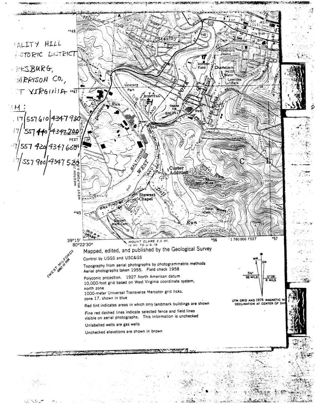
30
301 7½ Street SW
 301 7½ Street SW 104-0213-0072 Primary Resource Information: Single Dwelling, Stories 2.00, Style: Other, ca 1890 July 2006: This late-19th-century, 3-bay, 2-story, hip-roofed frame I-house features projecting
808 Cherry Avenue
 808 Cherry Avenue 104-0213-0059 Primary Resource Information: Single Dwelling, Stories 2.00, Style: Other, ca 1900 July 2006: This 2-story, 3-bay frame I-house features a central-front gable, a brick pier
1 Gildersleeve Wood (DHR # )
") GILDERSLEEVE WOOD 1 Gildersleeve Wood (DHR # 104-5092-0012) STREET ADDRESS: 1 Gildersleeve Wood MAP & PARCEL: 11-20 PRESENT ZONING: R-1U ORIGINAL OWNER: Lindsay Family ORIGINAL USE: PRESENT USE: PRESENT
GILDERSLEEVE WOOD 1 Gildersleeve Wood (DHR # 104-5092-0012) STREET ADDRESS: 1 Gildersleeve Wood MAP & PARCEL: 11-20 PRESENT ZONING: R-1U ORIGINAL OWNER: Lindsay Family ORIGINAL USE: PRESENT USE: PRESENT
National Register of Historic Places Inventory Nomination Form
 NPS Form 10-900-a Exp. 10-31-84 Continuation sheet 4 5 item number 7 Page 45 NAME: Knight Estate LOCATION: 486 East Avenue,,--v..u^-^ OWNER: State of Rhode Island Department of Education Board of Regents
500 Preston Place. Garages PRESENT USE: Garages PRESENT OWNER: Preston Court Limited Partnership ADDRESS:
 PRESTON PLACE 500 Preston Place STREET 500 Preston Place MAP & PARCEL: 5-116 Garages Garages PRESENT OWNER: Preston Court Limited Partnership 413 7 th Street NE Charlottesville, Va. 22902 DATE/ PERIOD:
Intensive Level Historic Resources Survey 5.0 ANNOTATED LIST OF PROPERTIES
 Intensive Level Historic Resources Survey 5.0 ANNOTATED LIST OF PROPERTIES CBCA PN 05-012A May 2009 Photo Location Description 10760 Bodine Road Date: 1811 Historic addition of side block to the rear;
THE CORPORATION OF THE TOWN OF NIAGARA-ON-THE-LAKE. BY-LAW NO (214 Four Mile Creek Road)
") THE CORPORATION OF THE TOWN OF NIAGARA-ON-THE-LAKE BY-LAW NO. 4807-15 (214 Four Mile Creek Road) A BY-LAW TO DESIGNATE THE PROPERTY KNOWN MUNICIPALLY AS WOODBOURNE, 214 FOUR MILE CREEK ROAD, IN THE TOWN
THE CORPORATION OF THE TOWN OF NIAGARA-ON-THE-LAKE BY-LAW NO. 4807-15 (214 Four Mile Creek Road) A BY-LAW TO DESIGNATE THE PROPERTY KNOWN MUNICIPALLY AS WOODBOURNE, 214 FOUR MILE CREEK ROAD, IN THE TOWN
Cross Street Walking Tour
 Cross Street Walking Tour 1. 33 King Street West: Collins Hotel: 1840 s This impressive building was constructed in 1841 by Bernard Collins. The gallery and Greek style portico were built in the 1850 s
DESIGNATION REPORT KENNEDY-BAKER-WALKER-SHERRILL HOUSE (1849) 9320 KINGSTON PIKE (CLT ) KNOXVILLE, TENNESSEE July 12, 2007
 9320 KINGSTON PIKE (CLT ) KNOXVILLE, TENNESSEE July 12, 2007") DESIGNATION REPORT KENNEDY-BAKER-WALKER-SHERRILL HOUSE (1849) 9320 KINGSTON PIKE (CLT 132-027) KNOXVILLE, TENNESSEE July 12, 2007 Description The Kennedy-Baker-Walker-Sherrill House is located on the south
DESIGNATION REPORT KENNEDY-BAKER-WALKER-SHERRILL HOUSE (1849) 9320 KINGSTON PIKE (CLT 132-027) KNOXVILLE, TENNESSEE July 12, 2007 Description The Kennedy-Baker-Walker-Sherrill House is located on the south
Seaforth Walking Tour
 Seaforth Walking Tour 1: Victoria Park The land for Victoria Park was donated to the Town by Dr. William Gouinlock in 1875, (one year after Seaforth was officially incorporated). The bandshell was constructed
Type of Building. By-law
 1 2-2-storey frame house on stone rubble foundation. - Built by Mead - "Ontario " plan. - Centred gable with arched window in gable. Meads 202 John Plan 20, Part Lot 20 1895 Residence - Shutters on the
ADDENDUM. Chain of Title. Block C, Lot 8-9. Adrian I. Velthuis and Floyd T. Grant to Lottie Thompson
 Chain of Title Block C, Lot 8-9 NLP 5175:842 October 18, 1979 NLP 4979:58 October 5, 1977 NLP 4763:448 May 11, 1977 Adrian I. Velthuis and Floyd T. Grant to Lottie Thompson Gentlemens II Properties, Inc.,
National Register of Historic Places Registration Form
 NPS Form 10-900 OMB No. 10024-0018 (Oct. 1990) United States Department of the Interior National Register of Historic Places Registration Form 1. historic name South Charles Town Historic District other
HB/10/06/003 Camus House, 46 Lisky Rd, Strabane. Foyle Valley
 Asset Ref No. Heritage Type House, Gates, Outbuildings, Walling Including Around Flax Drying Green. Built Post-Medieval house Location OS 6-inch map sheet Townland Parish LCA Foyle Valley ITM Coordinates
PROJECT: Rehabilitate Historic Bathhouses for Adaptive Use
 LOCATION: Hot Springs National Park, Hot Springs Arkansas SIZE: Approximately 105,000 sf among six buildings DATE: 2003-present ROLE: Project Manager for Historic Structure Reports, pre-design through
Delaware Avenue Between North and Tupper Streets Chuck La Chiusa
 Delaware Avenue Between North and Tupper Streets 2013 Chuck La Chiusa BuffaloAH.com Wilcox Mansison / Theodore Roosevelt Inaugural Site 641 Delaware Avenue Greek Revival/Colonial Revival Palladian window
Places state West Virginia code county Marion
 NPS Form 1W0 csaa, United States Department of the lnteria? National Park Service National Register of Historic Inventory-Nomination Form See instructions in How to Complete National Register Forms Type
Proposed East Sanford Historic District DRAFT
 Proposed East Sanford Historic District DRAFT Inventory List The following inventory list provides basic information for all properties in the East Sanford Historic District. Included are each property
National Register of Historic Places Registration Form
 NPS Form 10-900 OMB No. 10024-0018 (Oct. 1990) Registration Form This form is for use in nominating or requesting determinations for individual properties and districts. See instructions in How to Complete
ri. Name historic: Oak Cliff United Methodist Church Date 7/17/97 and! or common:
 [ Dallas Landmark Landmark Nomination Commission Form ri. Name historic: Oak Cliff United Methodist Church Date 7/17/97 and! or common: L2. Location addresses: 541-49 E. Jefferson location! neighborhood:
24 EARL STREET WALKING TOUR
 24 EARL STREET WALKING TOUR This walk covers four city blocks of Earl Street, one of the oldest streets in Kingston. APPROXIMATELY 45 MINUTES Please be respectful of private property. 24 EARL STREET WALKING
56 QUEEN STREET. Neo-Classic. architectural description. Architect Merwin Austin, Rochester, N.Y. Port Hope Town Hall circa
 Architect Merwin Austin, Rochester, N.Y. Date Designated: June 27, 1994 to By-Law No. 21/94, SCHEDULE B-1 Lot Description: PT 51 (PART OF ORIGINAL TOWN LOTS S 48, 49, 50 architectural description S et
Type of Building. By-law
 1 2 Architectural and General Context - Two storey wood-frame residence with vinyl clad exterior. - Property was original purchased by William Newton, a local physician. - Hip roof. - Windows have shutters.
The George Rieley home place, built 1852, from bricks molded and baked on the premises.
 The George Rieley home place, built 1852, from bricks molded and baked on the premises. 1. SUBJECT: Old Riley [sic] Place. 2. LOCATION: 1/16 mile east of Blue Ridge Va. on Route /460. House on north side
SURVEY OF PUBLIC HOUSES WESTON TURVILLE
 BUCKINGHAMSHIRE ARCHAEOLOGICAL SOCIETY HISTORIC BUILDINGS GROUP SURVEY OF PUBLIC HOUSES IN THE PARISH OF WESTON TURVILLE BUCKINGHAMSHIRE A record of extant buildings that are currently or were formerly
NPS Form OMB No Exp Status occupied X unoccupied work in progress Accessible yes: restricted yes: unrestricted _5Lno
 NPS Form 10-900 OMB No. 1024-0018 Exp. 10-31-84 United States Department of the Interior National Park Service National Register of Historic Places Inventory Nomination Form See instructions in How to
Address 347 Whitney Street. East elevation, camera facing southwest.
 FORM B BUILDING Assessor s Number USGS Quad Area(s) Form Number MASSACHUSETTS HISTORICAL COMMISSION MASSACHUSETTS ARCHIVES BUILDING 220 MORRISSEY BOULEVARD BOSTON, MASSACHUSETTS 02125 Town Northborough
Maryland Historical Trust Inventory No. PG: 86A-026 Maryland Inventory of Historic Properties Form
 Inventory No. PG: 86A-026 Maryland Inventory of 1. Name of Property (indicate preferred name) historic other 2. Location street and number 12811 Croom Road not for publication city, town Naylor vicinity
APPENDIX A HISTORIC RESOURCES INVENTORY FEATURE LOCATION OWNERSHIP DESCRIPTION
 APPENDIX A HISTORIC RESOURCES INVENTORY FEATURE LOCATION OWNERSHIP DESCRIPTION Map 1 - Sea Ranch North Del Mar West of Highway 1 This gable roof board and batten in The Sea Ranch cottage is one of the
CHRONOLOGY & DEVELOPMENT BOUDINOT-SOUTHARD PROPERTY BASKING RIDGE, NJ OF THE
 CHRONOLOGY & DEVELOPMENT OF THE BOUDINOT-SOUTHARD PROPERTY BASKING RIDGE, NJ Elias Boudinot 1740 Elias Boudinot born May 2 in Philadelphia, where his family was a neighbor of Benjamin Franklin. 1760 Boudinot
1. Name of Property Historic name: _Pomeroy Terrace Historic District Other names/site number: Name of related multiple property listing:
 United States Department of the Interior National Park Service National Register of Historic Places Registration Form This form is for use in nominating or requesting determinations for individual properties
CITY OF ST. THOMAS, ONTARIO DESIGNATED HERITAGE PROPERTIES
 CITY OF ST. THOMAS, ONTARIO DESIGNATED HERITAGE PROPERTIES Photos (click for larger image) Name/ Address Date Designated/ By-law Number Description Old St. Thomas Church, 55 Walnut Street October 18 th,
National Register of Historic Places Registration Form
 NPS Form 10-900 OMB No. 10024-0018 (Oct. 1990) Registration Form This form is for use in nominating or requesting determinations for individual properties and districts. See instructions in How to Complete
APPENDIX K: BUILT HERITAGE AND CULTURAL HERITAGE LANDSCAPES
 APPENDIX K: BUILT HERITAGE AND CULTURAL HERITAGE LANDSCAPES TABLE 1: Built Resources (BHR) and Cultural Heritage Landscapes (CHL) Within and Adjacent to the West Whitby Secondary Plan Area Site # 1. CHL
Robert Dawson Senior
 Robert Dawson Senior Dawson Family 85.13.1 DBP3B (cropped) The man sitting on the right of the photograph with the tall hat is Robert Dawson Sr. Standing to his left is his wife, Martha, and Robert Jr.,
OMB No NPS Form (Rev. 8-86) NATIONAL REGISTER OF HISTORIC PLACES REGISTRATION FORM
 NATIONAL REGISTER OF HISTORIC PLACES REGISTRATION FORM") NPS Form 10-900 (Rev. 8-86) OMB No. 1024-0018 nited States Department of the Interior NATIONAL REGISTER OF HISTORIC PLACES REGISTRATION FORM other name/site number: TIERNAN - RILEY HOUSE not for publication:
NPS Form 10-900 (Rev. 8-86) OMB No. 1024-0018 nited States Department of the Interior NATIONAL REGISTER OF HISTORIC PLACES REGISTRATION FORM other name/site number: TIERNAN - RILEY HOUSE not for publication:
Maryland Historical Trust Inventory No. PG: Maryland Inventory of Historic Properties Form
 Inventory No. PG: 62-012 Maryland Inventory of 1. Name of Property (indicate preferred name) historic other 2. Location street and number 11205 Old Baltimore Pike not for publication city, town Beltsville
3. Classification -- Category Ownership Status Present Use
 United States Department of the Interior National Park Service?htbn~! Register of klkt~rk Places For HPS UM only received Inventory-Nomination Form date entered See instructions in How to Complete National
Newark Historic Places Tour
 Copyright by GPSmyCity.com - Page 1 - Newark Historic Places Tour Founded in 1666, Newark is home to numerous historic places, such as districts, buildings, parks, cemeteries and statuary. Many of its
THE CHATHAM-KENT MUNICIPAL HERITAGE REGISTER
 THE CHATHAM-KENT MUNICIPAL HERITAGE REGISTER Listed Properties in the Community of Tilbury Photo Credit: W.J. Bolton/Canada. Dept. of Manpower and Immigration/Library and Archives Canada/PA-031135, 1923-1924
[GJ RETXESENTATiON IN EXISTING SUBVZYS E~~%LOCATIOM - V~CINETY 84 LEGAL DESCIIIPTION I T~UIOWNER OF PROPERTY --- *
 NATIONAL PARK SERVICE 1 SEE IN STRUCTI 0 N S IN HOW TO COMPLETE NATlONAL REGISTER FORMS TYPE ALL ENTRIES -- COFdlPLETE APPLICABLE SECTIONS I bherty House - AND/OR COMMON STREET & NUMBER 705 Kalvern Avenue
United States Department of the Interior National Park Service NATIONAL REGISTER OF HISTORIC PLACES REGISTRATION FORM. Wilmoth, Bernard E.
 NPS Form 10-900 OMB No. 10024-0018 (Oct. 1990) United States Department of the Interior National Park Service NATIONAL REGISTER OF HISTORIC PLACES REGISTRATION FORM 1. Name of Property historic name: other
City of Kingston Report to Municipal Heritage Committee Report Number MHC
 To: From: Resource Staff: Date of Meeting: August 25, 2014 Subject: City of Kingston Report to Municipal Heritage Committee Report Number MHC-14-055 Chair and Members of Municipal Heritage Committee Lanie
 Page 1 Original Update HISTORICAL STRUCTURE FORM FLORIDA MASTER SITE FILE Consult Guide To Historical Structure Forms for detailed instructions Site # 8OR9844 Recorder # 26 Recorder Date 2/20/08 Site Name
HISTORIC SITE FORM HISTORIC SITES INVENTORY
 HISTORIC SITE FORM HISTORIC SITES INVENTORY 1 IDENTIFICATION Name of Property: House at 569 Park Avenue PARK CITY MUNICIPAL CORPORATION (10-08) Address: 569 Park Avenue City, County: Park City, Summit
September 13, Presented by: Jeremy Parsons PLANNING & ECONOMIC DEVELOPMENT DEPARTMENT
 Recommendation to Designate Property Located at 828 Sanatorium Road, Hamilton (Mountain Sanatorium Brow Campus) Under Part IV of the Ontario Heritage Act () September 13, 2018 Presented by: Jeremy Parsons
National Register of Historic Places Registration Form
 NPS Form 10-900 (Rev. 01/2009) OMB No. 1024-0018 United States Department of the Interior National Park Service National Register of Historic Places Registration Form This form is for use in nominating
STATE OF IOWA. Historical and Architectural Survey for 2008 Flood Projects in Vinton, Benton County
 STATE OF IOWA CHESTER J. CULVER GOVERNOR PATTY JUDGE LT. GOVERNOR DEPARTMENT OF PUBLIC DEFENSE IOWA HOMELAND SECURITY AND EMERGENCY MANAGEMENT DIVISION DAVID L. MILLER, ADMINISTRATOR Historical and Architectural
MEDIA ADVISORY. FOR IMMEDIATE RELEASE November 12, 2012
 MEDIA ADVISORY FOR IMMEDIATE RELEASE November 12, 2012 Niagara-on-the-Lake On Monday, November 19, 2012, the Lord Mayor and members of the Town s Municipal Heritage Committee and War of 1812 Bicentennial
ate: AR County: Pulaski Code: AR Zip Code: Noncontributing buildings sites structures objects Total
 Mims-Ereedlove-Priest-Weatherton House Name of Property Little Rock, AR County and State ~- -,s Form 10-900 'V. 8-86) OMB No. 1024-0018 United States Department of the Interior National Park Service NATIONAL
THE BARNACLE 3485 MAIN HIGHWAY
 THE BARNACLE 3485 MAIN HIGHWAY Designation Report City of Miami REPORT OF THE CITY OF MIAMI PLANNING AND ZONING DEPARTMENT TO THE HISTORIC AND ENVIRONMENTAL PRESERVATION BOARD ON THE POTENTIAL DESIGNATION
Change dormers and main entry on the river side of the house. Site: 43 Riverbank Road, Block 10 Lot 3
 City of Burlington Historic Preservation Commission Meeting Minutes: December 2, 2015 The City of Burlington Historic Preservation Commission held its regular monthly meeting on Wednesday, December 2,
Charles Pillsbury Allen House
 Charles Pillsbury Allen House 1380 Rocky Lake Drive circa 1847 In 1831, Charles Pillsbury Allen (1805-1862) started his Chair and Bucket Manufactory in Fall River. In 1847, Mr. Allen (1805-1862) bought
City of Burlington Historic Preservation Commission Meeting Minutes: September 4, 2013
 City of Burlington Historic Preservation Commission Meeting Minutes: September 4, 2013 The City of Burlington Historic Preservation Commission held its regular monthly meeting on Wednesday, September 4,
Claro Community Archaeology Group
 Site Record Form Item Number Claro Community Archaeology Group 60940162 Date Initials Inspected Access Visibility NGR Centre 434513 458452 NGR Linear Item Description HALL HOUSE Site Data Old Hall Coach
MAPLEWOOD HISTORIC PRESERVATION COMMISSION Maplewood Municipal Building Designation Report for Historic Landmark. Landmark #D December, 2009
 MAPLEWOOD HISTORIC PRESERVATION COMMISSION Maplewood Municipal Building Designation Report for Historic Landmark Landmark #D010-09 December, 2009 Boundary Description: Maplewood Municipal Building Historic
Hunter Water S170 Register
 SHI No.: 3630112 Location Name: 800 Salisbury Rd, Munni NSW 2420 Other ID nos HW ID: 130. Description: The house is set on a buff over looking the creek The house is built in the colonial style, single
Houses on the east side of River Street, camera facing northeast. Date (month/year) March 2009
 March 2009") FORM A - AREA MASSACHUSETTS HISTORICAL COMMISSION MASSACHUSETTS ARCHIVES BUILDING 220 MORRISSEY BOULEVARD BOSTON, MASSACHUSETTS 02125 Assessor s Sheets USGS Quad Area Letter Form Numbers in Area Shrewsbury
FORM A - AREA MASSACHUSETTS HISTORICAL COMMISSION MASSACHUSETTS ARCHIVES BUILDING 220 MORRISSEY BOULEVARD BOSTON, MASSACHUSETTS 02125 Assessor s Sheets USGS Quad Area Letter Form Numbers in Area Shrewsbury
May's Island Historic District. Cedar Rapids. Multiple, see continuation sheet. Linn County Courthouse. 3rd Avenue Bridge. Iowa Linn.
 May's Island Historic District Cedar Rapids Iowa Linn Multiple, see continuation sheet Linn County Courthouse 3rd Avenue Bridge Cedar Rapids Iowa Cedar Rapids is located on the Cedar River, which bisects
Heritage Caledon Walking Tour Series
 Heritage Caledon Walking Tour Series Cheltenham Tour Please respect private property * Designated under the Ontario Heritage Act 1 14318 Creditview Road *Charles Haines House circa 1835 Constructed for
NATIONAL REGISTER OF HISTORIC PLACES REGISTRATION FORM
 (Rev. 10-90) NPS Form 10-900 OMB No. 1024-0018 NATIONAL REGISTER OF HISTORIC PLACES REGISTRATION FORM This form is for use in nominating or requesting determinations for individual properties and districts.
Architectural Inventory Form
 OAHP1403 Rev. 9/98 COLORADO CULTURAL RESOURCE SURVEY Architectural Inventory Form Official eligibility determination (OAHP use only) Date Initials Determined Eligible- NR Determined Not Eligible- NR Determined
June 23, The Clayton Historic District is bounded by Mulberry Street, West Barnes Street, Mill Street, South Lombard Street and Blanche Street.
 June 23, 2010 This is the Clayton Historic District nomination to the National Register of Historic Places prepared by National Register Consultant Nancy Van Dolsen of Wilson, NC. The presentation was
STATE CODE COUNTY CODE West Virginia 54 Harrison 033
 I UNlTED STATES DEPARTMENT OF THE INTERIOR NATIONAL PARK SERVICE NATIONAL REGISTER OF HISTORIC PLACES INVENTORY -- NOMINATION FORM NAME HISTORIC AND/OR COMMON LOCATION STREET & NUMBER CITY. TOWN SEE INSTRUCTIONS
City of Burlington Historic Preservation Commission Meeting Minutes: July 6, 2016
 City of Burlington Historic Preservation Commission Meeting Minutes: July 6, 2016 The City of Burlington Historic Preservation Commission held its regular monthly meeting on Wednesday, July 6, 2016 at
CITY OF MURFREESBORO HISTORIC ZONING COMMISSION. Regular Meeting June 19, :30 PM, Council Chambers, City Hall
 CITY OF MURFREESBORO HISTORIC ZONING COMMISSION Regular Meeting June 19, 2018 3:30 PM, Council Chambers, City Hall I. Call to Order and determination of a quorum II. Approve Minutes of the Regular Meeting
Fletchertown (71A-022)
") Fletchertown (71A-022) Fletchertown is a late-nineteenth-century rural African-American community in northeastern Prince George s County. The community is located south of Huntington and northwest of Bowie.
Fletchertown (71A-022) Fletchertown is a late-nineteenth-century rural African-American community in northeastern Prince George s County. The community is located south of Huntington and northwest of Bowie.
Architectural Styles of Stone Buildings of Ancaster
 Architectural Styles of Stone Buildings of Ancaster Text by Robert Williamson, Feb. 29, 2008 With photos by Gerard Middleton Research by Jim Green Ancaster Township has an abundance of stone buildings,
Maryland Historical Trust Inventory No. PG: 75A-007 Maryland Inventory of Historic Properties Form
 Inventory No. PG: 75A-007 Maryland Inventory of 1. Name of Property (indicate preferred name) historic other 2. Location street and number 3101 Ritchie Road not for publication city, town Forestville vicinity
New Orleans Historic District Landmarks Commission Nomination Report 210 State Street, former NOAH Campus July 17, 2014
 New Orleans Historic District Landmarks Commission Nomination Report 210 State Street, former NOAH Campus July 17, 2014 Meeting Date: July 17, 2014 Property Address: Owner: 210 State Street Children s
NATIONAL REGISTER OF HISTORIC PLACES REGISTRATION FORM
 (Rev. 10-90) NPS Form 10-900 OMB No. 1024-0018 NATIONAL REGISTER OF HISTORIC PLACES REGISTRATION FORM This form is for use in nominating or requesting determinations for individual properties and districts.
National Register of Historic Places Continuation Sheet
 Section number N/A Page 1 Proposed Amendment to Wichita, Sedgwick County, Kansas The owner of the building at 141 S. Rock Island Avenue requests amendment to the boundaries of the East Douglas Historic
- - CITY. TOWN CONGRESSIONAL DISTRICT. Princeton, VICINITY OF. STATE CODE COUNTY CODE West Virginia 54 Mercer 055
 UNITtD S DEPAKTMkNT OF THE IN1 EKIOR NATIONAL PARK SERVICE NATIONAL REGISTER OF HISTORIC PLACES INVENTORY -- NOMINATION FORM NAME HISTORIC AND/OR COMMON SEE INSTRUCTIONS IN HOW TO COMPLETE NATIONAL REGISTER
Doncaster Market Place Conservation Area
 Doncaster Market Place Conservation Area Review December 2014 www.doncaster.gov.uk/conservationareas Doncaster Market Place Conservation Area Review Since the appraisal undertaken in March 2007, the general
 ~. ',. ( NPS Form 10-900 (Rev. 8-86) NR I ;s+eca Cf/ S /q~ OMB No. 1024-0018 United States Department of the Interior National Park Service NATIONAL REGISTER OF HISTORIC PLACES REGISTRATION FORM ------------------------------------------------------------------------
ELMET(E) HALL By Anthony Silson
 HALL By Anthony Silson") From Oak Leaves, Part 9, Autumn 2009 - published by Oakwood and District Historical Society [ODHS] ELMET(E) HALL By Anthony Silson Elmet(e) Hall is an impressive building that stands on elevated ground
From Oak Leaves, Part 9, Autumn 2009 - published by Oakwood and District Historical Society [ODHS] ELMET(E) HALL By Anthony Silson Elmet(e) Hall is an impressive building that stands on elevated ground
HISTORIC DISTRICT STUDY COMMITTEE REPORT GEORGE FARMSTEAD HISTORIC DISTRICT OAKLAND TOWNSHIP, MICHIGAN
 HISTORIC DISTRICT STUDY COMMITTEE REPORT GEORGE FARMSTEAD HISTORIC DISTRICT OAKLAND TOWNSHIP, MICHIGAN HISTORIC DISTRICT STUDY COMMITTEE REPORT GEORGE FARMSTEAD HISTORIC DISTRICT OAKLAND TOWNSHIP, MICHIGAN
Walking Tour and. Historic District. Neighborhood Guide. Historical and Architectural Information
 923 S Center Street 1205 S 6th Street Historical and Architectural Information Farrington s Grove is Terre Haute s oldest surviving neighborhood. Terre Haute, whose name is French for high land, was founded
The Anthony Spengler Home (Spengler Hall or Matin Hill)
") The Anthony Spengler Home (Spengler Hall or Matin Hill) Location: On the western edge of Strasburg, Virginia, on the west side of Route 11 Built: circa 1800 Owners: At a Commissioner's sale, Isaac Hite,
The Anthony Spengler Home (Spengler Hall or Matin Hill) Location: On the western edge of Strasburg, Virginia, on the west side of Route 11 Built: circa 1800 Owners: At a Commissioner's sale, Isaac Hite,
Maryland Historical Trust Inventory No. PG: 86A-003 Maryland Inventory of Historic Properties Form
 Inventory No. PG: 86A-003 Maryland Inventory of 1. Name of Property (indicate preferred name) historic other 2. Location street and number 12005 Duley Station Road not for publication city, town Upper
April 28, Reuben McKnight Historic Preservation Officer 747 Market Street, Suite 1036 Tacoma, WA Dear Mr. McKnight:
 April 28, 2016 Reuben McKnight Historic Preservation Officer 747 Market Street, Suite 1036 Tacoma, WA 98402 Dear Mr. McKnight: I am delighted to inform you that the Buckley s Addition Historic District
National Register of Historic Places Registration Form
 NPS Form 10-900 OMB No. 10024-0018 (Oct. 1990) United States Department of the Interior National Park Service National Register of Historic Places Registration Form 1. Name of Property historic name other
Commonwealth of Massachusetts Massachusetts Historical Commission 220 Morrissey Boulevard, Boston, Massachusetts
 Inventory No: Historic Name: Common Name: Address: HRV.173 Rand, Jonathan House and Farm Taylor, William Jr. - Barnard, Ephraim House 44 Littleton County Rd City/Town: Village/Neighborhood: Local No: 23-20,21
THE FORMER BRADBURY HALL, CHATSWORTH ROAD, CHESTERFIELD. GROUP LEADER, DEVELOPMENT MANAGEMENT
 AGENDA ITEM NO. 7 THE FORMER BRADBURY HALL, CHATSWORTH ROAD, CHESTERFIELD. MEETING: PLANNING COMMITTEE DATE: 17 TH MAY 2004 REPORT BY: WARD: COMMUNITY FORUM: GROUP LEADER, DEVELOPMENT MANAGEMENT HOLMEBROOK
FLAGLER WORKER S HOUSE FORT DALLAS PARK S.E. 4 STREET
 FLAGLER WORKER S HOUSE FORT DALLAS PARK 60-64 S.E. 4 STREET Designation Report City of Miami REPORT OF THE CITY OF MIAMI PLANNING DEPARTMENT TO THE HERITAGE CONSERVATION BOARD ON THE POTENTIAL DESIGNATION
state: West Virginia code: county: Wirt code: 105 zip code: 26143
 NPS Form 10-900 (Rev. 10-90) OMB NO. 1024-0018 - 1. Name of Property historic name: Wirt County Courthouse other nameslsite number: N/A 2. Location street & number: Washington Street not for publication:
Commonwealth of Massachusetts Massachusetts Historical Commission 220 Morrissey Boulevard, Boston, Massachusetts
 Inventory No: Historic Name: Common Name: Address: NWB.3010 Colonial Beacon Oil Company Shed Blue Frontier Yacht Services Office 115 Water St City/Town: Newburyport Village/Neighborhood: Local No: 20-10
APPENDIX D Existing Inventory of Cary's Historic Resources
 APPENDIX D Existing Inventory of Cary's Historic Resources The word inventory has a variety of meanings and connotations. In classic historic preservation methodology, it is the first of a three-step process:
APPENDIX B. Historic Structures
 University of Arkansas, Fayetteville Campus Old Main. The University Hall building was built from 1872 74 and modeled after the main building of the University of Illinois. The building itself is a demonstration
3. Classification. 5. Location of Legal Description. 6. Representation in Existing Surveys
 N~~ Form 10.900 (382) OMB No. 10240018 Exp. 103164 United States Department of the Interior National Park Service National Register of Historic Places InventoryNomination Form See instructions in How to
HENNIGAN PLACE. This photograph is circa November Name, address, and telephone number of the present owner and occupant of the property:
 HENNIGAN PLACE This report was written on November 7, 1979 This photograph is circa November 2006. 1. Name and location of the property: The property known as the Hennigan Place is located at 3503 Tilley
Chedoke. Statement of Heritage Significance. Appendix B to Report PED13153(a) 1 of 18. Description of Historic Place.
 1 of 18. Description of Historic Place.") 1 of 18 Chedoke Statement of Heritage Significance Description of Historic Place The building at One Balfour Drive, known as Chedoke, is situated on approximately four acres of land on the Niagara Escarpment
1 of 18 Chedoke Statement of Heritage Significance Description of Historic Place The building at One Balfour Drive, known as Chedoke, is situated on approximately four acres of land on the Niagara Escarpment
QUEEN STREET BUSINESS SECTION
 Walk 2 QUEEN STREET BUSINESS SECTION 27 DURHAM 26 25 LAMBTON 21 24 23 22Ä20 QUEEN STREET Ä19 18 17 14Ä13 12Ä12 16 15 Most of the stores were built in Renaissance Revival style in the 1880 s, replacing
National Register of Historic Places Registration Form
 NPS Form 10-900 OMB No. 10024-0018 (Oct. 1990) United States Department of the Interior National Park Service National Register of Historic Places Registration Form 1. Name of Property historic name Scott
Type of Building. By-law
 1 2-2 1/2 storey duplexed, brick residence - Property was originally purchased by Percy M. Watson in 1908. - Symmetrical windows. - Hip roof with dormer facing the street. Percy M. Watson 70 Niagara Plan
WILLIAM TRELOAR HOUSE
 WILLIAM TRELOAR HOUSE This report was written on July 3, 1984 1. Name and location of the property: The property known as the William Treloar House is located at 328 N. Brevard St. in Charlotte, NC. 2.
National Register of Historic Places Registration Form
 PS Form 10-900 OMB No. 10024-0018 (Oct. 1990) United States Department of the Interior National Park Service Registration Form This form is for use in nominating or requesting determinations for individual
East and north elevations, camera facing west. Condition Good
 FORM B BUILDING MASSACHUSETTS HISTORICAL COMMISSION MASSACHUSETTS ARCHIVES BUILDING 220 MORRISSEY BOULEVARD BOSTON, MASSACHUSETTS 02125 Assessor s Number USGS Quad Area(s) Form Number Town Northborough
RESEARCH AND EVALUATION SUMMARY: 297 AND 299 SHERBOURNE STREET
 ATTACHMENT NO. 6 RESEARCH AND EVALUATION SUMMARY: 297 AND 299 SHERBOURNE STREET William Elliott Houses: principal (west) elevations (Heritage Preservation Services, 2016) HISTORICAL CHRONOLOGY Key Date
Hwy Retaining Wall/ Sea Wall. Not Eligible, see Statement of Significance Also member of listed NR district: Mantorville Historic District
 Historic Name CS # 2007 Other Name SHPO Inv # Location E and W sides of TH 57 between 6th St and 7th St Hwy District Reference City/Township County Mantorville, City of Dodge Acres Twp Rng Sec 107N 16W