Shepparton North East
|
|
|
- Della Montgomery
- 5 years ago
- Views:
Transcription


1 Shepparton North East Background Report October 2017
2 CONTENTS 1. INTRODUCTION LOCAL CONTEXT Current land uses Lot size & land ownership pattern Topography Cultural heritage Vegetation Soil contamination Access & movement Community facilities Open space & recreation FUTURE URBAN STRUCTURE Services Drainage and stormwater management Transport & movement Open space Community infrastructure Activity centre analysis Housing DEVELOPMENT CONTRIBUTIONS REFERENCES PLANS Plan 1. Regional Context.4 Plan 2. Future Urban Structure. 15
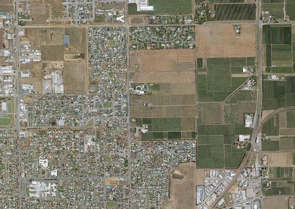
3 1. INTRODUCTION The Shepparton North East Precinct Structure Plan (the PSP) applies to approximately 177 hectares of land located three kilometres north-east of the Shepparton CBD, as illustrated on Plan 1. The precinct is bounded by Verney Road to the west, the low-density Matilda Drive residential development and Ford Road to the north, the Goulburn-Murray Water (G-MW) Drain 3 to the south, and a G-MW channel and Grahamvale Road to the east. The main land use within the precinct is a mixture of intensive horticulture, other agriculture, and ancillary farming uses. There are a small number of rural residential lots to the south west of the precinct along Verney Road. Reflecting these uses, land is primarily zoned Farming Zone 1 in the Greater Shepparton Planning Scheme. G-MW channels also traverse the precinct and are included in the Public Use Zone 1. The Greater Shepparton Housing Strategy 2011 (GSHS) identifies land to meet the future urban growth of the municipality until The strategy outlines the four main growth corridors identified in the Municipal Strategic Statement of the Greater Shepparton Planning Scheme will satisfy a significant portion of the predicted short to medium term growth. In addition to these growth corridors, the GSHS states that it is important that growth is maintained on a number of fronts, providing choice and variety in the housing market. The GSHS identifies a number of other corridors and estates that will aid in meeting this predicted demand. The Shepparton North East PSP will be one of the most extensive and important of these areas. The Greater Shepparton 2030 Strategy, 2006 and the Hume Regional Growth Plan, 2014 identify the majority of the land within the precinct for future residential development, with the exception of the south east corner that was not identified for residential development. It is identified as a special investigation area in the 2030 Strategy due to its proximity to industrial land. As part of the PSP process further investigation was undertaken and it has been determined this land is suitable for future residential development. The PSP, with the Shepparton North East Development Contributions Plan (the DCP) will provide the long-term vision for the future planning and development of the precinct. These plans will provide a broad framework that will coordinate development and assist in the transition of the area from non-urban to urban land. It is envisaged that the precinct will accommodate a population of approximately 4,000 residents and provide approximately 218 jobs. Future residents of the precinct will enjoy and benefit from the proposed environmental, social and economic assets proposed in the PSP. The Victorian Planning Authority (VPA) has prepared the PSP and DCP in collaboration with Greater Shepparton City Council (GSCC). GSCC commissioned and prepared all the background reporting and will be responsible for implementing the PSP. The Shepparton North East Precinct Background Report has been prepared by GSCC and assists in providing context to the PSP and its associated documents. A full list of the supporting documents that have informed the preparation of this background report and PSP can be found at the end of the document.
4 To Nu To Nathalia Plan 1 Local Context Shepparton North East PSP boundary existing growth corridor potential future investigation area Shepparton North Activity Centre residential existing retail existing government school existing non-government school community facility unencumbered open space encumbered open space railway line arterial road network future freeway bypass Sewerage Facility non urban area Primary / Secondary industrial area GRAHAMVALE ROAD existing urban area Primary / Secondary flood affected land (UFZ) rural living (RLZ) low density residential (LDRZ) Shepparton alternative route shared path cycle path Lower Goulburne National Park SHEPPARTON NORTH GROWTH CORRIDOR GOULBURN VALLEY HWY GOTAFE Technical Education Centre UFZ Secondary SHEPPARTON NORTH EAST PSP John McEwen Reserve Shepparton Golf Club Private Hospital Public Hospital Primary BALACLAVA ROAD Primary SHEPPARTON Gemmill amp Wildlife Reserve Secondary Goyen Reserve Native Flora & Fauna Reserve Mooroopna Golf Club ND HW LA Kids Town Adventure Playground D MI Secondary Deakin Sports Reserve SPC Showgrounds Y UFZ Secondary Primary DOYLE ROAD Cudgee Park Shepparton Railway Station Victoria Park Lake BEN ALLA ROA D
5 2. LOCAL CONTEXT 2.1. Current land uses Until recent years, the land within the precinct predominantly comprised of horticultural and ancillary farming uses and consisted mainly of fruit orchards, cool stores and associated rural residential lots. Increasingly, these orchards have been cleared of vegetation and replaced with other agricultural uses. There are two existing schools within the precinct area; Shepparton Christian College fronts onto Verney Road and Grahamvale Primary School fronts onto Grahamvale Road. The land surrounding the precinct comprises established residential uses to the north-west, south-west and west, industrial uses to the south-east, and horticultural and other agricultural uses to the east and north-east Lot size & land ownership pattern The precinct comprises of five primary landowners, with a number of additional smaller rural residential allotments in different holdings abutting Verney Road and Grahamvale Road. The majority of the precinct area is included in eight medium-to-large sized land parcels of hectares with the balance of the area made up of smaller rural residential land parcels; these land holding patterns reflect the traditional horticultural land uses that have occurred within the precinct Topography The precinct is characterised by very flat topography that is traversed by a network of G-MW channels and drains. The channels supply irrigation water to the land used for horticultural and other agricultural uses. The drains collect run-off water from agricultural land. The channels and drains traversing the precinct vary in width and depth. The precinct contains two main drainage catchments. The northern half of the precinct drains via a gentle slope to the north-west and into G-MW Drain 4, north of the precinct. The southern half of the precinct drains via a gentle slope to the south-west and into G-MW Drain 3, along the southern boundary of the precinct. G-MW has advised that Drain 4 has an extremely limited capacity to receive water from the site or to accept stormwater when the drain is running partially full. Reflecting this advice the discharge rate for Drain 4 is 0.4 litres / second / hectare. The discharge rate for Drain 3 is 1.2 litres / second / hectare. Two significant G-MW channels intersect the precinct. The channels are a constraint to future development and may impact upon development timing, as their continued use will impact the ability to effectively remodel the site to provide adequate drainage to some portions of the site until they are decommissioned. One of the channels also provides stock and domestic supply to a portion of the Matilda Drive residential development; this connection will need to be replaced as part of any decommissioning process.
6 2.4. Cultural heritage As part of the Environmental Assessment Report (ENSR Australia Pty Ltd, 2008) consultation was undertaken with the local Registered Aboriginal Party (RAP), the Yorta Yorta National Aboriginal Corporation. The assessment reported no places of Aboriginal cultural heritage significance recorded on the Victorian Aboriginal Heritage Register within the precinct. A very small area to the north-east of the precinct is identified as an area of cultural heritage sensitivity. The precinct has been subject to significant ground disturbance and is not considered to be sensitive. A late Victorian era homestead to the south-east of the precinct has been identified and assessed in the Draft Greater Shepparton Heritage Study ICC, June The homestead is considered to be of local historic and aesthetic cultural heritage significance to the City of Greater Shepparton Vegetation The precinct has previously been cleared of all native vegetation for agricultural, horticultural and residential uses. There are no natural biological features such as creeks, water bodies or patches of remnant native vegetation Soil contamination An environmental assessment of the precinct was undertaken by ENSR Australia Pty Ltd on behalf of AECOM Pty Ltd in October The assessment sought to identify potential contaminants within the soil that may constrain the development of the land. The assessment stated that the prior use of the land for farming purposes may have resulted in soil contamination through the use of pesticides and on-site storage of chemicals and fuel. The assessment recommended that further studies of the potential for land contamination be undertaken before subdivision Adverse amenity impacts The precinct directly abuts Shepparton s largest industrial precinct to the south east. The industrial precinct is predominantly zoned Industrial 1 Zone (IN1Z). The neighbouring precinct includes existing uses that may have adverse amenity impacts on the precinct area. Specifically, the precinct area is affected by potential adverse amenity buffers recommended in the Greater Shepparton Planning Scheme and the Environmental Protection Act: Petroleum storage facility 300 metres amenity buffer Bitumen batching plant 500 metres amenity buffer. The existing industrial area is very important for Shepparton economically and the uses identified are appropriate for this precinct and should be protected. Subsequently the amenity of neighbouring future residential land development should be protected. Land within the identified amenity buffers that encroach on the precinct was assessed for its capacity to accommodate residential development. An odour assessment was undertake by GHD Pty Ltd and a noise assessment was undertaken by Marshall Day Acoustics Pty Ltd. It was determined that if the appropriate measures were adopted, the land would be
7 predominantly suitable for residential development and comply with the applicable noise and odour criteria. The odour assessment concluded that the petroleum storage facility has underground tanks and therefore does not have any obligation under Victorian EPA legislation to meet any buffer distance requirements. It also recommended a de-rated directional amenity buffer relating to the bitumen batching plant be adopted in order to not pose any future limitation on the batching plants production. This buffer replaces the 500 metre default buffer in the Greater Shepparton Planning Scheme extending approximately 40 metres into a southern portion of the PSP. The noise assessment made a number of recommendations in accordance with Victorian EPA legislation, guidelines and accepted industry practice. Recommendation that have been adopted include: A minimum additional offset of 15 metres from the existing G-MW channel and future residential dwellings along Grahamvale Road due to traffic noise. Glazing and façade constructions for future dwellings on Ford Road, Verney Road and railway line be constructed to a higher specification due to traffic noise. Provision for a noise barrier along the interface with the industry on Apollo Drive in order to reduce noise from localised activities in the existing and future small commercial tenancies along that interface. This wall will also mitigate any potential impacts from the bitumen batching plant within the industrial area Access & movement Public Transport There are no public transport services currently operating within the precinct. Shepparton Transit operates a bus service along Verney Road that runs along the west boarder of the precinct. V/Line operates a train service to Melbourne that departs from Shepparton Station, approximately three kilometres south of the precinct. Road Network Grahamvale Road & Doyles Road Grahamvale Road (C391), in conjunction with Doyles Road, functions as a secondary arterial road and is the heavy vehicle bypass route for Shepparton. Doyles Road provides an important bypass route to the east of Shepparton, particularly for long distance commercial traffic between Melbourne and Brisbane along the Goulburn Valley / Newell Highway corridor. The Shepparton Alternate Route (SAR) is located within the Road Zone (Category 1) in the Greater Shepparton Planning Scheme and is controlled by VicRoads. It is a two-lane carriageway (one lane in each direction) with localised widening at some intersections to provide for right-turn deceleration lanes. Along the precinct frontage, Grahamvale Road comprises a two-lane two-way sealed carriageway with sealed shoulders, located centrally in a 20-metre road reservation, bounded to the east by the Shepparton-Tocumwal railway line and the west by a G-MW irrigation channel. The road generally operates under an 80km/h speed limit.
8 Doyles Road, just south of Grahamvale Road currently carries approximately 8,000 vehicles per day (26% heavy vehicles) between the Midland Highway and the Dookie-Shepparton Main Road (New Dookie Road). By 2031, it is predicted that this figure will increase to 9,900vpd. Verney Road Verney Road forms the western boundary to the precinct. The road is included in Road Zone (Category 2) in the Greater Shepparton Planning Scheme and is controlled by Council. Verney Road is designated as a trunk collector road in the local road network. It has a twolane, two-way cross section, augmented with turning lanes at major intersections. It is currently subject to a 60km/h speed limit along the precinct frontage, with a time-based 40 km/h school zone along the boundary of Shepparton Christian College. An off-road shared path has been constructed to the west of the reservation from Elm Terrace in the south to Ford Road in the north. GSCC has developed ultimate layout proposals for Verney Road from Ford Road to Balaclava Road; this upgrade includes widening the route to a two-lane (one lane in each direction) divided cross section to accommodate sheltered right-turn lanes at all significant intersections. The proposed cross section incorporates on-road bicycle lanes. The ultimate road layout proposals will be realised in three stages commencing at the Ford Road and Verney Road intersections. Stage one to the south of Hawkins Street was completed in the 2015/16 financial year, Stage two is nearing completion, and it is envisaged that Stage 3 will be commence in the 2017/18 financial year. Ford Road Ford Road forms part of the northern boundary to the PSP and is included in the Road Zone (Category 2). This is also designated as a trunk collector road in the local road network and it is managed by Council. It currently has a two-lane two-way cross section within a 20m road reservation width. Ford Road operates under a 60km/h speed limit. Council, in collaboration with VicRoads, is undertaking a study into the possible upgrade of Ford Road to serve as a critical link between the Goulburn Valley Highway and the Shepparton Alternate Route. The Ford Road and Wanganui Road Investigation Study seeks to explore the options and constraints to upgrading Ford and Wanganui Roads to serve as the direct link connecting Stage 1 of the Shepparton Bypass to the Shepparton Alternate Route. It is envisaged that Council will consider the Wanganui Road and Ford Road, Shepparton: Feasibility Study Design Report at an ordinary council meeting in late Apollo Drive & Gemini Crescent Apollo Drive and Gemini Crescent provide access to the existing industrial area south of the precinct. Both roads currently have a two-lane, two-way cross section within a 22-metre wide road reservation.
9 2.9. Community facilities The land is in proximity to a number of community facilities including the Shepparton North Neighbourhood Centre, the North Shepparton Community & Learning Centre, the Goulburn Valley Base Hospital and Shepparton Private Hospital, as well as a number of schools. Grahamvale Primary School and Shepparton Christian College are located within the precinct and the following schools are in close proximity; Verney Road School, Bourchier Street Primary School, Shepparton High School, St Luke s Primary School, Wanganui Secondary College and Goulburn Valley Grammar School Open space & recreation There are currently no designated public open spaces within the precinct. There is a limited diversity of existing public open spaces within the vicinity of the precinct. The open spaces that exist generally provide for local play functions within neighbouring residential areas to the west of Verney Road and south of the precinct. These open spaces only serve their local catchments and individually do not exceed 0.5 hectares in size. In a regional context, the precinct is proximate to the Shepparton Sports Precinct, a regional level sports precinct catering for a wide variety of sports including basketball, netball, tennis, hockey, athletics, soccer, BMX, equestrian, badminton and table tennis. The Goulburn River provides a major biodiversity corridor a recreation asset for the precinct and is located 2.5 kilometres to the west.
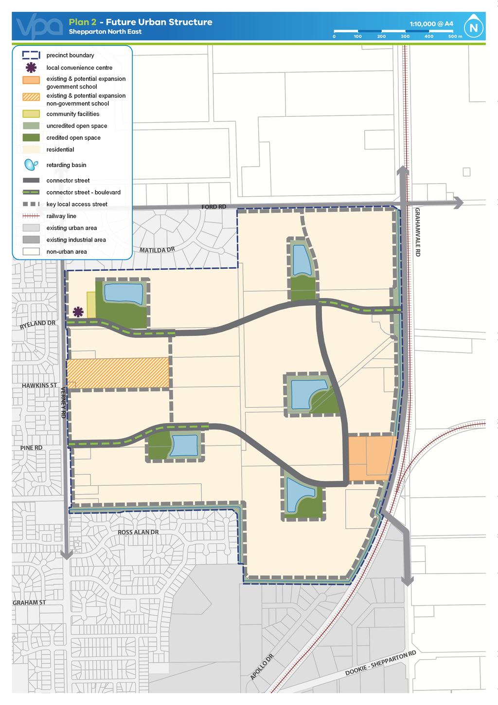
10 3. FUTURE URBAN STRUCTURE 3.1. Services A physical services assessment report was prepared by Maunsell Australia Pty Ltd in November The report confirmed that electricity, gas, sewer, telecommunications and water can be provided to the precinct area. The existing gas, telecommunication and water assets along Verney Road have sufficient capacity to service development within the precinct. Electricity can be supplied to the area from existing assets to the east, north or west of the precinct. In relation to sewer assets, there is sufficient capacity in the existing Verney Road sewer to accommodate the initial stages of development of the precinct. Sewer lines also exist along Ford Road and Grahamvale Road providing alterative options for the pumping of sewerage from the precinct. Overall, the report recommends that development should commence along Verney Road and extend eastwards to make the provision of services to the precinct area more cost effective; this will allow for the majority of services to be built from their current location rather than having to construct assets out of sequence Drainage and stormwater management Reeds Consulting Pty Ltd prepared a drainage strategy for the precinct area in September The strategy outlines the physical and statutory constraints that impact the provision of drainage facilities in the precinct area, as well as considering the desired public amenity outcomes. The drainage strategy heavily influenced the final layout of land uses identified in the PSP. The drainage strategy recommends the following: Five drainage catchment areas based on the existing conditions and constraints Drainage of each catchment via a gravity piped system to a retarding basin sized to cater for the appropriate storage requirements Stormwater quality treatment requirements for each catchment can be achieved via sediment ponds within each proposed retarding basin During a 1 in 500 year flood event a portion of the adjacent public reserve is to be inundated Existing G-MW channels and associated irrigation infrastructure within a catchment area should be decommissioned prior to the commencement of development in that area. Spiire Australia Pty Ltd undertook a peer review of the drainage strategy in March The peer review found that the five drainage catchments recommended by Reeds Consulting Pty Ltd drainage strategy would adequately satisfy the stormwater drainage requirements of the precinct area. In addition to preparing the drainage strategy, Reeds Consulting Pty Ltd also designed the functional design and costings for proposed Drainage Basin 1 in the north-west of the precinct. The functional design and costing was used on a pro rata basis to calculate the cost for the other four basins.
11 3.3. Transport & movement Trafficworks Pty Ltd was commissioned to undertake a traffic impact assessment report (TIAR) for the precinct in September In undertaking the assessment, Trafficworks Pty Ltd considered the previous draft traffic impact assessment report prepared by Maunsell Australia Pty Ltd (November 2008), the draft TIAR by AECOM Pty Ltd (December 2009) and the peer review of the AECOM Pty Ltd TIAR undertaken by TraffixGroup Pty Ltd (March 2011). The TIAR consolidated the findings included in each of the previous TIARs prepared for the precinct. It confirmed the traffic impacts of developing the precinct, commented on the transport network required to support the future residential development of the precinct and produced concept plans for the traffic infrastructure items. The TIAR considered the following: Existing and future road infrastructure and operating conditions surrounding the precinct Traffic generation and distribution characteristics of the precinct when fully developed Ability of the proposed road network to accommodate the future demands of the precinct Intersection type and layout to accommodate these future demands. The key findings and recommendations of the TIAR: External road access points for the precinct should be configured as follows: Access A: Verney Road opposite Ryeland Drive forming a signalised intersection Access B: Ford Road with a T-intersection, operating under give-way control west of Grahamvale Road Access C: Grahamvale Road forming a signalised intersection over the G-MW channel Access D: Verney Road diagonally opposite Pine Road, forming a signalised intersection The intersection of Pine Road and the Goulburn Valley Highway is currently signalised and has the capacity to cater for the anticipated small increase in traffic from the precinct. The TIAR made the following recommendations in relation to the road cross sections within the precinct: Street type Street Road Reservation Connector street Level 2 From accesses A, C and D for a 34 metres length outlined in the TIAR Connector street Level 1 All other connector roads within the 26 metres precinct Local access street Various 16 metres CDCE Pty Ltd prepared the functional layouts and costings for the intersections, as well as the cost of constructing a G-MW drain pedestrian bridge along Verney Road to the southwest of the precinct. Two main divergences have been made from the traffic modelling work: The first is the intersection layout and cross section concept plans as prepared by CDCE Pty Ltd relating to Access C (Grahamvale Road); VicRoads does not support the signalisation of this intersection and requires the construction of a roundabout.
12 The second is an additional access point for the precincts proposed employment area. This area will be provided with access via a T-intersection with Gemini Crescent. The intersection design will include an appropriate bridge crossing of G-MW Drain 3. Bus Stops The connector street network within the precinct has been designed to accommodate a bus route to serve future residents. Bus stops are to be positioned at locations to ensure 95% of all dwellings are located within a 400-metre walking distance of a bus stop. The final location of bus stops can be finalised during subdivision design and will consider the number of bus stops along Verney Road Open Pty Ltd was commissioned to undertake a recreation and open space assessment for the precinct. The assessment was tasked with ensuring that appropriate open space and recreation infrastructure is provided within the precinct that is of an adequate size and built form. The assessment determined that the proximity of the Shepparton Sports Precinct to the precinct meant that a full-sized sports reserve is not warranted. The assessment recommended that the following types and number of open spaces should be provided within the precinct: Two district parks (minimum two hectares in size), located adjacent to the Shepparton Christian College / proposed neighbourhood activity centre and the Grahamvale Primary School Three one-hectare local parks An off-road shared path to facilitate walking, cycling, dog walking, small-wheeled toys and skating (if sealed). A number of divergences have been made in finalising the open space provision within the precinct, these include: The second district park recommended to be located to the south-east of the precinct has been designated as a one-hectare local park. The infrastructure and facilities proposed for the district-level park adjacent to the proposed neighbourhood activity centre has been augmented accordingly. The G-MW Drain 3 to the south of the precinct will be redeveloped as adjacent development occurs and it will be re-established as a riparian corridor with vegetation buffers and a sheared path.
13 3.5. Community infrastructure A social infrastructure assessment was completed by Greater Shepparton City Council in The assessment sought to update the social infrastructure assessment prepared by Maunsell Australia Pty Ltd in November The assessment prepared by Maunsell Australia Pty Ltd recommended that: A community hub measuring 1,680 square metres be built in the precinct providing facilities for maternal and child health sessions, a preschool/kindergarten, occasional day-care service and community services Grahamvale Primary School be relocated and expanded to become part of the proposed neighbourhood centre The preferred location of the community hub is between the relocated Grahamvale Primary School and the proposed neighbourhood centre If the school is not relocated, the community hub should be located north of Shepparton Christian College along Verney Road GSCC and the Department of Education and Training (DET) should support existing schools in Shepparton to attract children locally Medium density housing should be located in proximity to the community hub and neighbourhood centre. The review largely supported the initial assessment and considered that: Grahamvale Primary School will remain at its current location and that the precinct should facilitate its expansion to include indoor and outdoor space Grahamvale Primary School and Shepparton Christian College may have future capacity to cater for residents in the precinct Many other schools available within close proximity to the precinct that can cater for population growth The activity centre will provide for maternal and child health sessions to be shared with other community groups/community services, as required, and a preschool/kindergarten potentially including occasional day care service There are currently sufficient aged care facilities in Shepparton Universal housing design will be utilised in private and public buildings, particularly to cater for the elderly and people with disabilities. Since the review it has been determined that an additional 1,680 square metres of land will be provided for to cater for the potential future expansion of the community facilities and provide additional circulation spaces and landscaping Activity centre analysis CPG Australia Pty Ltd was commissioned to undertake an activity centre analysis for the precinct in June The scope of the analysis included: Assessing the current and proposed retail services within the precinct Commenting on the community and expenditure profile of the area and precinct. Upon consideration of these factors and making a recommendation on the size and composition of the retail offer for a proposed activity centre within the precinct, the analysis identified a preferred location for an activity centre.
14 The analysis found that the precinct and the predicted level of expenditure in the surrounding catchment could support a supermarket development of 1,044 square metres with an additional 522 square metres of comparison shops and would generate a minimum parking requirement of 73 spaces. A site of approximately 3,756 square metres is required to support a supermarket, comparison shops and parking areas. The analysis considered the following four locations for the neighbourhood activity centre within the precinct: Along Verney Road, north of the Shepparton Christian College Along Grahamvale Road, south of Grahamvale Primary School Along Grahamvale Road, north of Grahamvale Primary School The centre of the precinct. The analysis considered that, while there are benefits and constraints to each of the options considered, the Verney Road option was the most appropriate site for the activity centre. It considered that an activity centre along Verney Road would likely be developed within the earlier stages of the precinct, and gain early use from the abutting existing residential areas Employment Local business and employment opportunities will be provided in the south east corner of the precinct, allowing residents to work and establish businesses close to where they live. This is in line with direction from the Hume Regional Growth Plan. The employment land will build upon and protect the existing industrial uses south of the precinct within the Shepparton East industrial precinct, Shepparton s major industrial area. The precinct will provide approximately 460 jobs for the local community Housing At full development, the precinct will accommodate in excess of 1,500 dwellings based upon an average density of 10 lots per hectare. It is expected that the majority of the lots within the precinct will be square metres in size. Despite this, it is encouraged that a greater provision of different lot sizes and a variety of built forms should be provided to cater for different households. The lot mix will also cater for a range of life cycle stages and age groups. Higher density housing will be encouraged around the Neighbourhood Activity Centre and district and local parks.
15 4. DEVELOPMENT CONTRIBUTIONS The PSP and DCP have been prepared by the Victorian Planning Authority in collaboration with Greater Shepparton City Council, service authorities and major stakeholders. The DCP has been developed to support the provision of works, services and facilities that will be used by the future residents and workers of the precinct. The DCP establishes a framework for development proponents to contribute a fair proportion of the cost of works and services required to support the future development of the precinct. It ensures that the cost of providing new infrastructure and services is shared equitably between developers and the wider community. Fairness requires costs to be apportioned according to the projected share of use, and the required works, services and facilities items. The key projects that are funded wholly or in part by development are listed in the DCP.
16
17 5. REFERENCES Draft Greater Shepparton Heritage Study Stage IIC (Heritage Concepts Pty Ltd, June 2017) Shepparton North East PSP Buffer Constraint and odour Impact Assessment (GHD Pty Ltd, June 2017) Shepparton North East PSP Noise Assessment (Marshall Day Acoustics Pty Ltd, July 2017) Shepparton East Overland Flow Urban Flood Study (BMT WBM Pty Ltd, December 2016) Desktop Drainage Strategy Review (Spiire Australia Pty Ltd, March 2016) Hume Regional Growth Plan (Department of Transport, Planning and Local Infrastructure, 2014) Drainage Strategy (Reeds Pty Ltd, July 2014) Traffic Impact Assessment Report (Trafficworks Pty Ltd, September 2014) Social Infrastructure Assessment (Greater Shepparton City Council, 2012) Economic Retail Assessment Report (CPG Australia Pty Ltd, June 2012) Open Space Peer Review Report Pty Ltd, May 2012) Greater Shepparton Housing Strategy (David Lock Associates, 2011) Traffic Impact Assessment Peer Review Report (TraffixGroup Pty Ltd, March 2011) Open Space Peer Review Report Pty Ltd, July 2010) Traffic Impact Assessment Report (AECOM Pty Ltd, December 2009) Traffic Impact Assessment Report (Maunsell Australia Pty Ltd, November 2008) Environmental Assessment Report (ENSR Australia Pty Ltd, November 2008) Open Space and Recreation Assessment Report (Maunsell Australia Pty Ltd, November 2008) Activity Centre Demand Report (Development Research Pty Ltd, December 2008) Physical Services Assessment Report (Maunsell Australia Pty Ltd, November 2008) Social Infrastructure Assessment Report (Maunsell Australia Pty Ltd, November 2008) Land and Supply Analysis Report (Spade Consultants Pty Ltd, December 2009) Greater Shepparton 2030 Strategy Plan (Greater Shepparton City Council, 2006)
18 Shepparton North East Background Report October 2017
LYNDHURST NEW URBAN DEVELOPMENT AREA STRUCTURE PLAN. Lyndhurst New Urban Development Area Structure Plan OUTCOMES AND PERFORMANCE STANDARDS
 APPENDIX 15.1-3 LYNDHURST NEW URBAN DEVELOPMENT AREA STRUCTURE PLAN Purpose of the Structure Plan Lyndhurst New Urban Development Area Structure Plan OUTCOMES AND PERFORMANCE STANDARDS LSP-P1 The District
Economic Retail Assessment Shepparton North East Growth Corridor. June Commissioned by City of Greater Shepparton
 June 2012 Commissioned by City of Greater Shepparton This report has been prepared from the office of CPG Level 3 469 La Trobe Street PO Box 305 South Melbourne 3205 T 9993 7888 Issue Date Revision No
Greater Shepparton City Council Planning Scheme Amendment C192 and C193 VicRoads Submission to Traffic Conclave
 Greater Shepparton City Council Planning Scheme Amendment C192 and C193 VicRoads Submission to Traffic Conclave Prepared by: Raelene Stratton Team Leader Integrated Transport and Land Use, North Eastern
PSP 75 Lancefield Road. Northern Jacksons Creek Crossing Supplementary Information
 PSP 75 Lancefield Road Northern Jacksons Creek Crossing Supplementary Information September 2017 The northern crossing of Jacksons Creek proposed within the Lancefield Road PSP is a key part of the ultimate
The implementation of this Master Plan will be undertaken in logical stages to meet passenger and workforce demands.
 The implementation of this Master Plan will be undertaken in logical stages to meet passenger and workforce demands. Connecting People Building Opportunities 198 Brisbane Airport Corporation CHAPTER 10
Review of Government Secondary School Requirements within the Sunbury South Precinct Structure Plan
 Review of Government Secondary School Requirements within the Sunbury South Precinct Structure Plan Expert Witness Statement August 11 th, 2017 Prepared by Robert Panozzo Director, ASR Research Pty Ltd
PLANNING THE SUNBURY GROWTH CORRIDOR
 SUNBURY GROWTH CORRIDOR NOVEMBER 2016 PLANNING THE SUNBURY GROWTH CORRIDOR Sunbury Planning Background The Victorian Planning Authority, in consultation with Hume City Council, is undertaking a number
Co-ordinated and Orderly Growth A Suite of Infrastructure and Public Assets for the Future... 1
 Co-ordinated and Orderly Growth... 1 A Suite of Infrastructure and Public Assets for the Future... 1 Funding Sources, Revenues and Prioritising Expenditure... 2 Stage 1 Short Term Growth Sunbury to 50,000...
Kilometres. Blacktown. Penrith. Parramatta. Liverpool Bankstown. Campbelltown
 0 5 10 15 20 Kilometres Penrith Blacktown Parramatta Liverpool Bankstown Campbelltown accessibility outcomes Legend Outcomes targeted in Western Sydney are: public transport that is accessible throughout
JOINT CORE STRATEGY FOR BROADLAND, NORWICH AND SOUTH NORFOLK EXAMINATION MATTER 3C EASTON/COSTESSEY
 Matter 3C Easton/Costessey Representor No. 8826 JOINT CORE STRATEGY FOR BROADLAND, NORWICH AND SOUTH NORFOLK EXAMINATION MATTER 3C EASTON/COSTESSEY SUBMISSION ON BEHALF OF TAYLOR WIMPEY DEVELOPMENTS AND
21.07 ECONOMIC DEVELOPMENT AND EMPLOYMENT 19/03/2015 C323 Proposed C Key issues and influences. Economic Role and Function
 21.07 ECONOMIC DEVELOPMENT AND EMPLOYMENT 19/03/2015 C323 Proposed C347 21.07-1 Key issues and influences 14/10/2010 C168 Economic Role and Function Geelong is the largest regional city in Victoria and
Airport Planning Area
 PLANNING AREA POLICIES l AIRPORT Airport Planning Area LOCATION AND CONTEXT The Airport Planning Area ( Airport area ) is a key part of Boise s economy and transportation network; it features a multi-purpose
E08. Kaufland Stores in Victoria Advisory Committee Epping. Request to be heard?:
 Kaufland Stores in Victoria Advisory Committee Epping E08 Request to be heard?: Yes Full Name: Organisation: Affected property: Attachment 1: Attachment 2: Attachment 3: Comments: Bernard McNamara BMDA
Presentation to Planning Panel
 Presentation to Planning Panel Amendment C207 & C208 to the Hume Planning Scheme Lancefield Road PSP & Sunbury South PSP August 2017 1 Historical Planning Context Sunbury has long been identified as a
URBAN DESIGN REPORT. Proposed Residential Development, Old Church Road, Caledon East
 Proposed Residential Development, Old Church Road, Caledon East TABLE CONTENTS: 1.0 DEVELOPMENT 1.1 Introduction-Analysis of Guiding Principles and Documents 1.2 Community Design and Architectural Design
5 PRECINCT INFRASTRUCTURE PLAN
 The following planning design guidelines should be met. Rainwater tanks are recommended for each dwelling other relevant building structures. Table 10: Category Drainage Drainage Floodplain Management
Donnybrook Precinct Structure Plan Utilities Servicing and Infrastructure Assessment
 Donnybrook Precinct Structure Plan Utilities Servicing and Infrastructure Assessment Project Number: CG130061 Prepared for Metropolitan Planning Authority 4 September 2014 Donnybrook Precinct Structure
Part four. In this part you will find: The next steps to deliver the master plan
 Part four NEXT STEPS In this part you will find: The next steps to deliver the master plan 6. How COULD the Master Plan be delivered? There are a number of steps required to take the proposals in the master
Whangarei Airport. Prepared by Carine Andries 10/20173
 Whangarei Airport Prepared by Carine Andries 10/20173 March 2010 TABLE OF CONTENTS 1 2 3 INTRODUCTION... 3 AIRPORT ROLE AND FUNCTION... 3 AIRPORT FEATURES AND CAPACITY... 3 3.1 3.2 3.3 3.4 3.5 3.5.1 3.5.2
TOWN PLANNING SUBMISSION TO THE GREATER SYDNEY COMMISSION LANDS AT ARTARMON
 TOWN PLANNING SUBMISSION TO THE GREATER SYDNEY COMMISSION LANDS AT ARTARMON March 2017 TABLE OF CONTENTS 1.0 INTRODUCTION 3 2.0 THE SUBJECT SITE 4 3.0 STRATEGIC PLANNING CONTEXT 6 4.0 SUMMARY AND CONCLUSIONS
Draft Planning Controls Planning Scheme Amendment GC81
 Draft Planning Controls Planning Scheme Amendment GC81 Peita Tapper Senior Planner, Planning Services What the planning controls do? The draft planning controls translate the objectives and strategies
Pre-application submission for Committee: Phase 4 development at West Hendon
 Pre-application submission for Committee: Phase 4 development at West Hendon 1. Development Details Phase 4 of the West Hendon Estate Regeneration. 2. Background The redevelopment of the West Hendon Estate
This economic statement provides analysis with respect to land at Tarneit North, and has been prepared on behalf of Amex Corporation.
 Memorandum To: From: Amex Corporation c/- Greg Wood, Tract Consultants Matthew Lee Cc: Date: 12 June 2013 Subject: Economic Statement for Amex site Tarneit North PSP Dear Greg, This economic statement
Green Fields Leppington
 Green Fields Leppington CONNTENTS 1.0 URBAN GROWTH - SYDNEY 2.0 MACRO CONTEXT 3.0 LOCAL ENVIRONMENTAL PLAN - LEPPINGTON 4.0 CONCEPT 5.0 GREEN ROOFS 6.0 APARTMENT REALISATION SCHEDULE 7.0 INFRASTRUCTURE
Gold Coast. Rapid Transit. Chapter content. Chapter four Route selection and staging
 Chapter four Route selection and staging Gold Coast Rapid Transit Chapter four Route selection and staging Chapter content Route selection...73 Section one: Helensvale to Griffith University...74 Section
Perth and Kinross Council Development Control Committee 27 August 2008 Recommendation by Development Quality Manager
 Perth and Kinross Council Development Control Committee 27 August 2008 Recommendation by Development Quality Manager 5(7) 08/414 Erection of kennels and cattery at Baltree Farm, Hatchbank, Kinross, KY13
Port Macquarie-Hastings Pedestrian Access and Mobility Plan. Working Paper COMMUNITY ENGAGEMENT
 Port Macquarie-Hastings Pedestrian Access and Mobility Plan Working Paper COMMUNITY ENGAGEMENT December 2014 Table of Contents Table of Contents... 2 1 Introduction... 3 2 Submissions... 3 2.1 Stakeholder
Parkland County Municipal Development Plan Amendment Acheson Industrial Area Structure Plan
 Parkland County Municipal Development Plan Amendment Acheson Industrial Area Structure Plan New Plan Acheson Industrial Area Structure Plan Amendment Parkland County Municipal Development Plan Board Reference
Bloor Street West Rezoning Application for a Temporary Use By-law Final Report
 STAFF REPORT ACTION REQUIRED 3741 3751 Bloor Street West Rezoning Application for a Temporary Use By-law Final Report Date: June 12, 2007 To: From: Wards: Reference Number: Etobicoke York Community Council
Date: 11 th January, From: Plaistow & Ifold Parish Neighbourhood Plan - Steering Group. Plaistow & Ifold Parish Council
 Date: 11 th January, 2017 From: Plaistow & Ifold Parish Neighbourhood Plan - Steering Group To: Plaistow & Ifold Parish Council Re: Neighbourhood Plan Report to Parish Council Meeting 17 Jan 2017 The Steering
5 Rail demand in Western Sydney
 5 Rail demand in Western Sydney About this chapter To better understand where new or enhanced rail services are needed, this chapter presents an overview of the existing and future demand on the rail network
PO Box 257 PO Box 257 PARRAMATTA NSW 2124 PARRAMATTA NSW 2124
 31 March 2017 Sean O Toole Sheridan Dudley District Commissioner - West District Commissioner - South West Greater Sydney Commission Greater Sydney Commission PO Box 257 PO Box 257 PARRAMATTA NSW 2124
Draft Greater Sydney Region Plan
 Powered by TCPDF (www.tcpdf.org) Draft Greater Sydney Region Plan Submission_id: 31119 Date of Lodgment: 12 Dec 2017 Origin of Submission: Online Organisation name: Serapark Pty Ltd Organisation type:
China Creek North Park Upgrades and Glen Pump Station. Park Board Committee Meeting Monday, July 10, 2017
 China Creek North Park Upgrades and Glen Pump Station Park Board Committee Meeting Monday, July 10, 2017 Purpose The purpose of this presentation is to: Share the results of the public engagement processes;
Proposal for gypsy and traveller accommodation on land at Lower Hollow Copse (Pot Common), Copthorne. Statement of Community Involvement
, Copthorne. Statement of Community Involvement") Proposal for gypsy and traveller accommodation on land at Lower Hollow Copse (Pot Common), Copthorne Statement of Community Involvement Prepared by WYG Environment Planning Transport Ltd on behalf of the
Proposal for gypsy and traveller accommodation on land at Lower Hollow Copse (Pot Common), Copthorne Statement of Community Involvement Prepared by WYG Environment Planning Transport Ltd on behalf of the
Armstrong Creek Horseshoe Bend Precinct Traffic Impact Assessment
 ` Armstrong Creek Horseshoe Bend Precinct Job Number: CG111786 Cardno Victoria Pty Ltd ABN 47 106 610 913 150 Oxford Street, Collingwood Victoria 3066 Australia Telephone: 03 8415 7777 Facsimile: 03 8415
3450 Dufferin Street - Official Plan Amendment, Zoning Amendment and Draft Plan of Subdivision Applications Request for Directions Report
 STAFF REPORT ACTION REQUIRED 3450 Dufferin Street - Official Plan Amendment, Zoning Amendment and Draft Plan of Subdivision Applications Request for Directions Report Date: March 15, 2017 To: From: Wards:
1 PROJECT STATUS UPDATE 2 ND CONCESSION FROM BRISTOL ROAD TO DOANE ROAD TOWNS OF EAST GWILLIMBURY AND NEWMARKET
 Report No. 3 of the Regional Council Meeting of March 28, 2013 1 PROJECT STATUS UPDATE 2 ND CONCESSION FROM BRISTOL ROAD TO DOANE ROAD TOWNS OF EAST GWILLIMBURY AND NEWMARKET The recommends: 1. Receipt
LINCOLN HEATH SOUTH PRECINCT BACKGROUND REPORT PSP NOVEMBER 2014
 LINCOLN HEATH SOUTH PRECINCT BACKGROUND REPORT NOVEMBER 2014 PSP 1207.1 Contents 1. INTRODUCTION... 3 2. METROPOLITAN AND REGIONAL CONTEXT... 5 3. LOCAL CONTEXT... 6 3.1. History... 6 3.2. Lot Size & Ownership
Gold Coast. Rapid Transit. Chapter twelve Social impact. Chapter content
 Gold Coast Rapid Transit Chapter twelve Social impact Chapter content Social impact assessment process...235 Existing community profile...237 Consultation...238 Social impacts and mitigation strategies...239
Seek the Board s approval for the Donald Place kerb and channel renewal to progress to final design, tender and construction; and
 3. DONALD PLACE - KERB AND CHANNEL RENEWAL General Manager responsible: General Manager City Environment Officer responsible: Transport and City Streets Manager Author: Michelle Flanagan, Streets Capital
Schedule of Planning Applications Committee Date: 23 May Reference: 06/18/0064/F Great Yarmouth Officer: Mr J Beck Expiry Date:
 Schedule of Planning Applications Committee Date: 23 May 2018 Reference: 06/18/0064/F Great Yarmouth Officer: Mr J Beck Expiry Date: 24-04-2018 Applicant: Proposal: Site: Mr Mavroudis Clear weather hoardings
Bridge School, Longmoor Campus, Coppice View Road, Sutton Coldfield, Birmingham, B73 6UE
 Committee Date: 22/01/2015 Application Number: 2014/05949/PA Accepted: 08/12/2014 Application Type: Full Planning Target Date: 02/02/2015 Ward: Sutton Vesey Bridge School, Longmoor Campus, Coppice View
2433 Dufferin Street Zoning By-law Amendment Application - Preliminary Report
 STAFF REPORT ACTION REQUIRED 2433 Dufferin Street Zoning By-law Amendment Application - Preliminary Report Date: July 22, 2014 To: From: Wards: Reference Number: North York Community Council Director,
Amendments C207 & C208
 Amendments C207 & C208 Hume Planning Scheme Julia Bell August 2017 Instructed by KING&WOOD MALLESONS On behalf of Hume City Council Amendments C207 & C208 Hume Planning Scheme Contents 1.0 Introduction...
Spadina Avenue Built Form Study Preliminary Report
 STAFF REPORT ACTION REQUIRED Spadina Avenue Built Form Study Preliminary Report Date: July 9, 2014 To: From: Wards: Reference Number: Toronto and East York Community Council Director, Community Planning,
Proposed Arthurs Point Special Housing Area. Housing Accords and Special Housing Areas Act Expression of Interest
 Proposed Arthurs Point Special Housing Area Housing Accords and Special Housing Areas Act 2013 Expression of Interest 1.0 APPLICANT The applicant for the proposed Arthurs Point Special Housing Area is
Dookie and District Action Plan
 Dookie and District Action Plan 2017-18 Goal Actions Partnerships Timeframe Status Strategic Goals (i.e Council pillar) Rail Trail Continue to seek funding options for Stage 2 of the Rail Trail (to Cosgrove)
This is a submission to Council s Delivery Plan and Operational Plan
 Goulburn Mulwaree Council Locked Bag 22 Goulburn NSW 2580 Emailed: strategy@goulburn.nsw.gov.au and council@goulburn.nsw.gov.au Marulan/Tallong Community Network C/O 843 Marulan South Road Marulan NSW,
12, 14 and 16 York Street - Amendments to Section 16 Agreement and Road Closure Authorization
 REPORT FOR ACTION 12, 14 and 16 York Street - Amendments to Section 16 Agreement and Road Closure Authorization Date: April 27, 2018 To: Toronto and East York Community Council From: Senior Strategic Director,
Energy from Waste and Recycling Facility Trident Park, Cardiff. Planning History. January 2010 SLR Ref: B
 Energy from Waste and Recycling Facility Trident Park, Cardiff Planning History January 2010 Ref: 402-0036-0306B Viridor Ltd. i 402/0036/00306B CONTENTS 1.0 INTRODUCTION... 1 2.0 GENERAL HISTORY... 3
PERTH-ADELAIDE CORRIDOR STRATEGY
 INTRODUCTION The Royal Automobile Association of SA Inc (RAA), the State s principal advocate for motorists on a broad range of motoring-related issues, represents the views of more than 560,000 South
Hume Amendment C207 Sunbury South PSP
 s Hume Amendment C207 Expert Evidence Traffic and Transport V171123 Prepared for HWL Ebsworth Lawyers 11 August 2017 Document Information Prepared for HWL Ebsworth Lawyers Project Name File Reference V171123_PAN001F01.docx
SUBMISSION BY THE BOARD OF AIRLINE REPRESENTATIVES OF NEW ZEALAND ON THE DRAFT QUEENSTOWN LAKES DISTRICT COUNCIL DRAFT PLAN
 SUBMISSION BY THE BOARD OF AIRLINE REPRESENTATIVES OF NEW ZEALAND ON THE DRAFT QUEENSTOWN LAKES DISTRICT COUNCIL DRAFT PLAN Background to BARNZ BARNZ is an incorporated society comprising 19 member airlines
MONTEREY REGIONAL AIRPORT MASTER PLAN TOPICAL QUESTIONS FROM THE PLANNING ADVISORY COMMITTEE AND TOPICAL RESPONSES
 MONTEREY REGIONAL AIRPORT MASTER PLAN TOPICAL QUESTIONS FROM THE PLANNING ADVISORY COMMITTEE AND TOPICAL RESPONSES Recurring topics emerged in some of the comments and questions raised by members of the
PART VIII APPLICATION FOR REVISED SOUTH SIDE TRAFFIC MANAGEMENT WORKS TO FACILITATE LUAS BXD PLANNING REPORT ROADS & TRAFFIC DEPARTMENT
 PART VIII APPLICATION FOR REVISED SOUTH SIDE TRAFFIC MANAGEMENT WORKS TO FACILITATE LUAS BXD PLANNING REPORT ROADS & TRAFFIC DEPARTMENT NOVEMBER 2012 1.0 INTRODUCTION This report has been prepared in support
I508. Devonport Peninsula Precinct
 I508. Devonport Peninsula Precinct I508.1. Precinct description The purpose of the Devonport Peninsula precinct is to provide for the comprehensive residential development of the former Navy housing land
Recreation Management Plan Lake Baroon and Ewen Maddock Dam
 Lake Baroon and Ewen Maddock Dam December 2013 Contents Overview... 3 The Value of Our Natural Areas... 4 Management Approach... 6 Funding... 7 Recreation Management... 8 Conditions of Access and Use...
REGIONAL BOARD REPORT
 REGIONAL BOARD REPORT Administrator s Office For the Board August 21, 2008 DATE: August 14, 2008 FILE NOS.: A-07-06377/8/9.000 FROM: RE: Chief Administrative Officer OCP and Zoning Amendment Application
Sport Capital Improvement Plan. Paul Borci Manager, Campus Planning Property & Campus Services
 Sport Capital Improvement Plan Paul Borci Manager, Campus Planning Property & Campus Services What is SCIP? Property and Campus Services (PCS) in collaboration with Melbourne University Sport (MU Sport)
Response to the London Heathrow Airport Expansion Public Consultation
 Response to the London Heathrow Airport Expansion Public Consultation Summary This report sets out the response to the Heathrow Airport s consultation on airport expansion and airspace change. The consultation
Beveridge North West PSP Retail and Needs Assessment
 Beveridge North West PSP 1059 Retail and Needs Assessment Prepared for Metropolitan Planning Authority by Essential Economics Pty Ltd A u g u s t 2 0 1 4 Authorship Report stage Author Date Review Date
SUMMER VILLAGE OF SILVER SANDS. Municipal Development Plan
 SUMMER VILLAGE OF SILVER SANDS Municipal Development Plan Bylaw 253-2014 Adopted August 22, 2014 Summer Village of Silver Sands Municipal Development Plan Bylaw No. 253-2014 Page 2 1 INTRODUCTION 1.1 SETTING
Metropolitan Planning Authority 25-Jul Thompsons Road, Clyde Creek and Casey Fields South (Residential) PSPs 53, 54 & 57.1 Transport Modelling
 PSPs 53, 54 & 57.1 Transport Modelling") Metropolitan Planning Authority Thompsons Road, Clyde Creek and Casey Fields South (Residential) PSPs 53, 54 & 57.1 Transport Modelling Thompsons Road, Clyde Creek and Casey Fields South (Residential)
Metropolitan Planning Authority Thompsons Road, Clyde Creek and Casey Fields South (Residential) PSPs 53, 54 & 57.1 Transport Modelling Thompsons Road, Clyde Creek and Casey Fields South (Residential)
Traffic and Transport Assessment
 Traffic and Transport Assessment Section 96A Residential Subdivision, Wincity Sunbury CG140997 Prepared for Wincity Development 4 December 2015 Document Information Prepared for Wincity Development Project
Draft Western District Plan
 Powered by TCPDF (www.tcpdf.org) Draft Western District Plan Submission_id: 31732 Date of Lodgment: 15 Dec 2017 Origin of Submission: Online Organisation name: APP Corporation Pty Ltd Organisation type:
What options were considered
 What options were considered As part of the initial planning for the new runway, several options were identified and assessed before determining that the new runway is the most appropriate development
Llandudno Junction. Regeneration Proposals for the Future. December 2009
 Llandudno Junction Regeneration Proposals for the Future December 2009 Llandudno Junction - Vision Statement 1 Purpose 1.1 The purpose of this document is to describe key priorities to support the regeneration
draft planning controls
 Introduction The South precinct is bounded by Danks, Bourke, McEvoy and Morehead streets. Current land uses include Sydney Water s heritage listed Waterloo Pumping Station and Valve ouse, warehouses, commercial
A Master Plan is one of the most important documents that can be prepared by an Airport.
 The Master Plan A Master Plan is one of the most important documents that can be prepared by an Airport. A Master Plan is a visionary and a strategic document detailing planning initiatives for the Airport
Sunshine Coast Airport Master Plan September 2007
 Sunshine Coast Airport Master Plan September 2007 Contents CONTENTS... I ACKNOWLEDGEMENT... II DISCLAIMER... III 1 EXECUTIVE SUMMARY...IV 1 INTRODUCTION... 1 2 AVIATION DEMAND FORECAST... 5 3 AIRCRAFT
Land Management Summary
 photo credit: ANGAIR Anglesea Heath Land Management Summary The Anglesea Heath (6,501 ha) was incorporated into the Great Otway National Park in January 2018. This provides an opportunity to consider the
Connecting People Building Opportunities BRISBANE AIRPORT 2014 MASTER PLAN
 Connecting People Building Opportunities BRISBANE AIRPORT 2014 MASTER PLAN MASTER PLAN 2014 PROPOSED AIRPORT DEVELOPMENT STRATEGY 2034 Important Notice This Master Plan has been prepared by Brisbane Airport
SUBURBPROFILE POPULATION TO DOUBLE OV E RVIE W CITY OF WY ND H AM FORECAST POPULATION WYNDHAM CITY COUNCIL
 TA R NI E T 1 SUBURBPROFILE The suburb is located within the boundaries of the City of Wyndham which is one of the fastest growing municipalities in Victoria and the third fastest in Australia. OV E RVIE
ASCOT SUBURB PROFILE
 ASCOT SUBURB PROFILE CONTENTS SUBURB HIGHLIGHTS 2 3 4 4 5 5 ASCOT & SURROUNDS LOCATION & LIFESTYLE DEMOGRAPHICS EMPLOYMENT FUTURE INFRASTRUCTURE WA MARKET TRENDS ACCESSIBILITY ENTERTAINMENT & RECREATION
ULDA Update Yarrabilba Project The Developers Perspective Tanya Martin Project Planner Communities Lend Lease June 2011
 ULDA Update Yarrabilba Project The Developers Perspective Tanya Martin Project Planner Communities Lend Lease June 2011 Development Context & Approvals Background The Region Strategic Location Single Ownership
Open Report on behalf of Richard Wills, Executive Director for Environment and Economy
 Agenda Item 7 Executive Open Report on behalf of Richard Wills, Executive Director for Environment and Economy Report to: Executive Date: 02 September 2014 Subject: Lincoln East West Link Road Phase 1
CHRISTCHURCH MOTORWAYS. Project Summary Statement February 2010
 CHRISTCHURCH MOTORWAYS Project Summary Statement February 2010 Table of Contents 1. Purpose of Document 2. Strategic Context 3. Benefits 4. Project Scope and Economics 5. Implementation Plan 1 ROADS OF
Launceston City Council. Kings Meadows Traffic Management Report for Public Consultation
 Launceston City Council Kings Meadows Traffic Management Report for Public Consultation November 2013 This report: has been prepared by GHD for Launceston City Council and may only be used and relied on
EAST DON TRAIL ENVIRONMENTAL ASSESSMENT. Community Liaison Committee Meeting #3 July 15, :30 to 8:30 pm Flemingdon Park Library
 EAST DON TRAIL ENVIRONMENTAL ASSESSMENT Community Liaison Committee Meeting #3 July 15, 2013 6:30 to 8:30 pm Flemingdon Park Library Agenda 1. Welcome 2. Housekeeping and Updates a) Housekeeping b) CLC
Major Scheme Business Case Summary Report for Programme Entry
 Paper A Heart of South West Local Transport Board Major Scheme Business Case Summary Report for Programme Entry M5 Junction 25, Taunton July 2016 1 SCHEME SUMMARY Scheme Name M5 Junction 25, Taunton Date
TERMINAL DEVELOPMENT PLAN
 5.0 TERMINAL DEVELOPMENT PLAN 5.0 TERMINAL DEVELOPMENT PLAN Key points The development plan in the Master Plan includes the expansion of terminal infrastructure, creating integrated terminals for international,
ROCKBANK PRECINCT STRUCTURE PLAN
 Rockbank Precinct Structure Plan August 2016 potential rail stabling yard Primary OLD LEAKES RD PAYNES RD WESTCOTT PDE TOOLERN RD ROCKBANK RD Primary LEONID DR Rockb Town Primary ES RD Primary ROCKBANK
Regional Town Centre and Employment Land Assessment
 Regional Town Centre and Employment Land Assessment PSP 1067 Donnybrook PSP 1096 Woodstock PSP 25.2 English Street Prepared for Metropolitan Planning Authority by Essential Economics Pty Ltd J u n e 2
Memorandum of Understanding with ACT Government
 MEDIA RELEASE 8 April 2015 Memorandum of Understanding with ACT Government The ACT Government and Canberra Airport today entered into a new Memorandum of Understanding (MoU) on key areas of common interest
Other Principle Arterials Minor Arterial Major Collector Minor Collector Local
 CHAPTER 10 TRANSPORTATION Introduction The system of public roads in East Pikeland Township is decidedly rural in character. Since the 1984, the road network has remained much the same, with the addition
fact sheet fact sheet Minnippi Masterplan. Squirrel Glider Habitat Public Open Space Medium Density Proposed Public Golf Course Medium Density
 P ROJ E C T OV E RV I E W Minnippi comprises a Brisbane City Council owned public golf course, conservation areas and new housing to be developed on a total of 125 hectares between Creek Road, Fursden
West of England. Priority Places Requiring Public Investment
 West of England Priority Places Requiring Public Investment Development Urban Regeneration & Suburban Intensification Bristol Central Area Bristol Central Area; Stokes Croft, Temple Meads & St Philips
Rule Governing the Designation and Establishment of All-Terrain Vehicle Use Trails on State Land
 Rule Governing the Designation and Establishment of All-Terrain Vehicle Use Trails on State Land 1.0 Authority 1.1 This rule is promulgated pursuant to 23 V.S.A. 3506. Section 3506 (b)(4) states that an
Sainsburys Store, Mere Green Road, Sutton Coldfield, Birmingham, B75 5BT
 Committee Date: 7/0/013 Application Number: 013/04/PA Accepted: 1/04/013 Application Type: Variation of Condition Target Date: 1/07/013 Ward: Sutton Four Oaks Sainsburys Store, Mere Green Road, Sutton
CITY RAIL LINK. New Public Transport Stations and Development Opportunities at Karangahape Road, Newton and Aotea Quarter
 134 AC_BEU_CCMP_3_TM5_8_FD.indd 134 20/07/12 12:30 PM 05 CITY RAIL LINK New Public Transport Stations and Development Opportunities at Karangahape Road, Newton and Aotea Quarter 5 MO VE 0 1 2 8 KEY 1 Britomart
SOUTH INTERCHANGE AREA
 Santaquin City General Plan 1 Location and Characteristics The South Interchange Area of Santaquin is located west of Interstate 15 and south of 500 South (Figure 1). It includes properties already annexed
LIVE. WORK. PLAY. STATUS OF DEVELOPMENT FALL Produced for information by the Town of Markham
 LIVE. WORK. PLAY. STATUS OF DEVELOPMENT Produced for information by the Town of Markham Community TOWN OF MARKHAM CIVIC CENTRE 101 TOWN CENTRE BOULEVARD Completed in 1989. East of Town Centre Boulevard,
Longmont to Boulder Regional Trail Jay Road Connection DRAFT FINAL REPORT
 Longmont to Boulder Regional Trail Jay Road Connection DRAFT FINAL REPORT December 2018 Project Summary Boulder County, Colorado, in partnership with the City of Boulder, is evaluating options for multi-use
9.1 INTRODUCTION 9.2 EXISTING DEVELOPMENT. Southern Cross University
 Property Strategy The property strategy delivers improved legibility, responds to the locational attributes of the site, and facilitates essential operational efficiencies. 9.1 INTRODUCTION Non-aviation
PCAL Case Study Retail Areas: Rouse Hill Town Centre
 PCAL Case Study Retail Areas: Rouse Hill Town Centre Introduction Rouse Hill Town Centre is a new mixed use development on a greenfield site in Sydney s North West. It has been planned to be a major hub
CORPORATE ACCOMMODATION SOLUTIONS
 CORPORATE ACCOMMODATION SOLUTIONS TABLE OF CONTENTS EXECUTIVE SUMMARY 3 THE LOCATION 4 KEY FEATURES 5 MASTERPLAN 8 TRANSPORT & PARKING 9 EAST VILLAGE 10 INDICATIVE SCHEME 11 ABOUT THE DEVELOPER 14 2 EXECUTIVE
A. CONCLUSIONS OF THE FGEIS
 Chapter 11: Traffic and Parking A. CONCLUSIONS OF THE FGEIS The FGEIS found that the Approved Plan will generate a substantial volume of vehicular and pedestrian activity, including an estimated 1,300
Report to: Greater Cambridge Partnership Joint Assembly 18 January A10 Foxton level crossing bypass and travel hub
 Report to: Greater Cambridge Partnership Joint Assembly 18 January 2018 Lead officer: Chris Tunstall GCP Director of Transport A10 Foxton level crossing bypass and travel hub 1. Purpose 1.1 The list of
BINDA PLACE IMPROVEMENT PLAN
 BINDA PLACE IMPROVEMENT PLAN Endorsed December 2014 December 2015 update Ph (08) 9576 4600 Email: chatter@chittering.wa.gov.au Web: www.chittering.wa.gov.au Contents 1 EXECUTIVE SUMMARY... 1 2.0 PROJECT