Wellington City Council. Design Report: The Parade Island Bay
|
|
|
- Iris Dixon
- 6 years ago
- Views:
Transcription

1 Wellington City Council Design Report: The Parade Island Bay July 2017 For further information: Visit our website
2 2
3 Table of contents 1. Introduction Purpose Project Objectives Summary of Design Proposals Next Steps The Parade Process and Timeline Current Cycleway Project Approval and Construction Morrison Low Review of WCC Urban Cycleways Programme Aroha i te Kokoru Love the Bay The Parade - Context The Parade s Place in the WCC Cycleway Network Planning Island Bay to the City Traffic Volumes Guidance for Cycling Facilities Cyclist Volumes Road Safety Record Landscape and Urban Design Context Current Layout Public Feedback Road Safety Audits Design Statements & Love the Bay Drop in Options Empathy Design Community Insights Drop In Sessions Drop in Feedback Design Options Bus Stops Pedestrian Crossings General Items Design Proposals Option A Roadside Cycle Lane Next to Parking Original Layout with Enhancements Option B One-Way Separated Kerbside Cycleway Current Layout with Enhancements Option C One-Way Separated Kerbside Cycleway Above Road Level Option D One-Way Separated Kerbside Cycleway Above Road Level Landscape and Urban Design Approach Summary of Design Options
4 8.1 Intersections Rough Order Cost Estimates Options Considered But Not Pursued Opportunities Shorland Park Urban Design Dee Street Intersection On-Street Parking Speed Limits Next Steps
5 Table index Table 1 - The Parade Traffic Data, May Table 2 Dimensions of Facilities Adopted in Concept Design Table 3 - Rough Order Cost Estimate Summary Figure index Figure 1 Previous Island Bay Cycleway Process and Timeline... 9 Figure 2 Previous Island Bay to CBD Cycleway Feasibility Planning Figure 3 Potential Southern Connections Figure 4 Guidance on the Separation of Cyclists and Motor Vehicles Figure 5 Urban Design Context Figure 6 - Option A Roadside Cycle Lane Next to Parking Figure 7 - Option A - Artist Impressions Figure 8 - Option B - One-Way Separated Kerbside Cycleway Road Level Figure 9 - Option B - Artist Impressions Figure 10 - Option C - One-Way Separated Kerbside Cycleway Above Road Level Figure 11 - Option C - Artist Impressions Figure 12 - Option D - One-Way Separated Kerbside Cycleway Above Road Level Figure 13 - Option D - Artist Impressions Figure 14 - Threshold Concept Figure 15 - Intersection Concept Figure 16 - Option A Intersection Treatment Figure 17 - Options B to D Intersection Treatment Figure 18 - Shorland Park Opportunities Figure 19 - Dee Street Roundabout Figure 20 - The Parade Upgrade Delivery Programme Appendices Appendix A Love the Bay Design Objectives Appendix B Concept Design Option Plans Appendix C Concept Urban Design Studies and Specification 3
6 4
7 1. Introduction Wellington City Council (the Council) have engaged Tonkin + Taylor (T+T) and Studio Pacific Architecture (SPA) to consider the community feedback, (including suggested solutions) and apply engineering and urban design best practice, New Zealand & (applicable) Australian Standards and Guidelines to independently assess the full range of options. From this independent assessment, T+T and SPA have identified and developed four shortlisted design options that we consider best meets these standards, community desires and project objectives. This design report details this process, outlines why the four shortlisted options are preferred (pros and cons) and provides a description of these options to allow further consultation. Terms of reference for this assessment specify that the shortlisted options should include: Retain the current layout with enhancements, Return to the original layout with enhancements. 1.1 Purpose The Council has committed a significant amount of capital funding for cycleway development through its Long Term Plan and Annual Plan processes. The investments aim to contribute towards cycling becoming safer and more convenient (Cycling Master Plan & Framework 2015) by increasing the level of service for people who want to use bikes. Public reaction to some cycling developments, including the Island Bay cycleway prompted the NZ Transport Agency to undertake a review of the Council s Urban Cycleways Programme. Key findings included the need for greater community input and an integrated transport solution that encompasses a broader urban design/renewal approach. 1 The Parade, including the existing cycleway, is the subject of a reconfiguration that will include the results and feedback from the recent public engagement process. The purpose of this design report is to set out the concept design proposals for the reconfiguration of The Parade, including: The scope and features of the four concept design options The process used to reach the concept design options The design guidance and assumptions which support the options The parking impacts of each design option The urban design outcomes of each design option The rough order estimated costs of the options and improvements How public feedback has been accounted for in each option Other options that were considered but not pursued, and The next steps for the project. 1.2 Project Objectives The primary objective is to define options for reconfiguration of The Parade, identifying improvements that maximises benefits for all users including addressing the level of service for people who travel by bike, or otherwise choose an active transport mode. The proposals will: 1 (page 3) 5
8 Take the form of an integrated transport solution and encompass a broader urban design approach Reflect the need to consider the NZ Transport Agency guidelines for infrastructure design and also the Council s urban-design and transport related strategies, plans and guidelines Encourage sustainable and active transport through safe, convenient, connected (in terms of the wider Cycleways Programme Master Plan), and comfortable approaches as an investment outcome The proposals have been developed taking into account the input from the Love the Bay community engagement process. Generally, it is expected that the proposed improvements will: Improve the level of service for people on bikes along identified routes via a sensible and pragmatic approach Maintain or improve the level of service for pedestrians Improve or maintain the level of service for people using buses along identified routes Maintain an acceptable level of service for general traffic movements Maintain an acceptable level of on-street parking, accommodating changes to parking where necessary, to avoid substantial impacts on businesses, and to cater for other essential needs (e.g. parking at the medical centre, park & ride facilities) Improve the level of landscape and public realm amenity 1.3 Summary of Design Proposals Four concept design options have been developed for further public consultation. These options retain the current layout with enhancements, returns to the original layout with enhancements, and two others. The options take account of implementation cost and impact. The costs reflect community feedback to address safety concerns, environmental considerations, landscaping, and broader urban design opportunities along the length of The Parade. Enhancements have been made to reflect recommendations of the 2016 post-construction safety audit and peer review, current NZTA and engineering safety guidelines and broader urban design approaches Option A Roadside Cycle Lane Next to Parking Original Layout with Enhancements Prior to the construction of the Island Bay Cycleway, The Parade south of Medway Street had kerbside parking, a roadside cycle lane, and traffic lanes separated by a central flush median. Option A proposes a layout that, as close as safely possible, reflects the original design. Changes have been made to reflect the recommendations of the 2016 post-construction safety audit and peer review, and current NZTA and engineering safety guidelines that the original design did not include. It is these requirements that preclude a return to the exact original layout Option B One-Way Separated Kerbside Cycleway Current Layout with Enhancements Option B retains the current layout of a separated kerbside cycleway at road level. Design refinements include a raised concrete kerb separator between the cycleway and parked vehicles, and a consistent layout and design of the cycleway between the residential and business zones to achieve route continuity. This option requires the conversion of the current angle parking to parallel parking on the western side of The Parade, within the business area between Medway Street and Avon Street, and removal of the flush median Option C One-Way Separated Kerbside Cycleway Above Road Level Option C also provides a separated kerbside cycleway, with the cycleway above road level, either at mid-height between the roadway and footpath or at footpath level. A kerb will separate the cycleway vertically from the roadway (and footpath if at half-kerb height), and a horizontal buffer space 6
9 separating the cycleway from the adjacent parking door zone is provided by a 1.0m kerbside safety strip. The design provides a consistent layout of the cycleway between the residential and business zones to achieve route continuity. This option requires the conversion of the current angle parking to parallel parking on the western side of The Parade, within the business area between Medway Street and Avon Street, and removal of the flush median. This option results in a reduction in the existing pedestrian footpath width to 2.4m on the west side of the residential area. Within the business area, the west side pedestrian footpath reduces to 5.2m width, the east side increases to 3.5m width Option D One-Way Separated Kerbside Cycleway Above Road Level Option D is similar to similar to Option C, providing a separated kerbside cycleway, with the cycleway above road level, (either at mid-height between the roadway and footpath, or at footpath level). A kerb will separate the cycleway vertically from the roadway (and footpath if at half-kerb height), and a horizontal buffer space separating the cycleway from the adjacent parking door zone is provided by a 900mm kerbside safety strip (600mm at the angle parking area). The design provides a consistent layout of the cycleway between the residential and business zones to achieve route continuity. The footpath width is significantly reduced to 1.6m on the western side in the residential areas. Within the business area, the west side pedestrian footpath is also significantly reduced to 3.4m, resulting in a loss of space for footpath tables and seating. A central flush median and wider traffic lanes are provided in the residential area. The majority of the existing western kerbside angle parking remains between Medway Street and Avon Street. Full option descriptions are provided in later sections of this design report. The high-level concept designs are intended to convey the general layout of the road. Detailed design of a preferred final outcome for The Parade will develop in more detail the approved concept design and incorporate improvements identified through the public feedback and safety audit recommendations where appropriate. 1.4 Next Steps The four design options incorporate extensive community engagement, the outcomes of the Love the Bay project to date, transport engineering and landscape and urban design practice, NZTA guidelines, and council strategies, including the Urban Growth Plan, Cycling Master Plan and Framework, and Long Term Plan. The four design options for the Island Bay Parade and cycleway will be open for public consultation from 31 July 2017 to 13 August The consultation feedback will inform the final recommendations and report on the Island Bay Parade and Cycleway to be deliberated by Council on 14 September It is expected that Council will determine a final outcome for the design of The Parade at this meeting. 7
10 2. The Parade Process and Timeline 2.1 Current Cycleway Project Approval and Construction In July 2013, Wellington City Council commenced work on design options for cycle lanes on The Parade, between Shorland Park and Wakefield Park, which provides a spine route in Island Bay along The Parade and connects the parks, the coast with local shops and the village centre. In February 2014, Council wrote to 51 neighbours around the intersections of Humber, Mersey and Tamar Streets seeking initial views on very early design options. Feedback was used to refine the design. In April 2014, Council undertook a wider consultation with the community. This was reported to Council s Transport and Urban Development Committee on 20 May The Committee also heard from a number of interested parties at the meeting including those presenting a 400 signature petition against the project. The Committee decided to proceed with developing designs for kerbside lanes and undertake more consultation with the community. Between May and August 2014 Council engaged in further consultation with the community and particularly affected parties who live along The Parade. Council approved the project for implementation on 24 June 2015 following some 16 months of engagement, consultations and deliberations. The project was implemented between September 2015 and March Morrison Low Review of WCC Urban Cycleways Programme Public reaction to some cycling developments, including the Island Bay cycleway prompted the NZ Transport Agency to undertake a review of the Council s Urban Cycleways Programme (UCP). The NZ Transport Agency commissioned consultants Morrison Low to undertake the review in May 2016, which advised on whether the programme and implementation timetable was appropriate and realistic, and whether any barriers to progress the overall programme were identified and were being managed. A summary of the key findings and recommendations relevant to Island Bay were: There is a community perception that the cycleway in Island Bay is a poor solution and that it was delivered without proper community engagement and consultation. This perception has spilled over to other planned projects - these include perceptions of inadequate community engagement/ consultation, design and safety issues. In particular, the loss of parking and impacts on other users (drivers, pedestrians, businesses, homeowners) has been hard to explain. Some people commented that the UCP has driven a more aspirational approach to cycleway design and that this goes further than the community can understand or agree with. This is consistent with international experience. The adaptation of European cycle lane designs to New Zealand conditions is challenging and there are currently no agreed guidelines that can be uniformly applied. The three other projects of the Southern Route that would have delivered a cycleway connection between Island Bay and the Basin Reserve are now not currently part of WCC s programme and the roads that were in the frame have a greater safety risk profile than Island Bay. A review is necessary to circuit break Island Bay and re-engage the community on what an integrated transport solution could look like. Changes to what has been delivered will need to be made and these should reflect a broader urban design and regeneration approach. 8

11 Establish an approach and process for a review of Island Bay s cycleway. This needs to be done with the community. WCC Officials need to be given the opportunity to identify and advise on robust options for the design and delivery of a revised programme and opportunities to modify Island Bay. Elected members should provide political support for a recommissioned programme and a review of Island Bay, but should be careful to make decisions based on sound evidence and advice. On 30 June 2016, Council s Transport and Urban Development (TUD) Committee considered the Wellington City Urban Cycleways Programme paper 2, and resolved that: Agree that any consultation regarding changes to the cycle way in Island Bay take as long as necessary to get a suitable outcome and include a full range of options, including the status quo and original designs. 2.3 Aroha i te Kokoru Love the Bay A partnership approach between the Island Bay Residents Association and Cycle Aware Wellington and Council officers, co-designed to respond to the Island Bay re-engagement resolution of the 30 June 2016 TUD committee meeting was established, branded Love the Bay. The project has been established to act as a vehicle for constructive conversations and participation to develop a 10-year plan for Island Bay with a focus on The Parade Love the Bay worked together with the Island Bay community to shape a design brief for The Parade and the cycleway. The process and timeline from inception of the Island Bay cycleway to the beginning of the Love the Bay engagement is outlined below. Figure 1 Previous Island Bay Cycleway Process and Timeline

12 3. The Parade - Context 3.1 The Parade s Place in the WCC Cycleway Network Planning As early as May 2013, Wellington City Council commissioned a feasibility study from Opus International Consultants 3 for a corridor linking the suburb of Island Bay and the central business district (CBD). The study investigated a wide range of alternatives. The study: Concluded that this cycling corridor has a high strategic fit with the Government s policy objectives Recommended a scheme that would cater to the needs of both new and existing cyclists, and achieve the policy outcomes effectively, giving value for money. A design report prepared for the Island Bay Cycleway in August showed a diagram containing four sections. Figure 2 Previous Island Bay to CBD Cycleway Feasibility Planning The Island Bay Cycleway is one section within a wider future cycleway connection between Island Bay and the CBD. This future cycleway connection is outlined in the various Wellington City Council strategy documents, including: The Wellington City Council Cycling Framework The Wellington City Council Cycleways Programme Master Plan, September Section 1 containing The Parade was identified for quick implementation of a cycleway. With advanced design progress, it was adopted as a project for early implementation in the Cycleways Programme Master Plan, and the preferred programme in the Wellington Cycle Network Programme Business Case, February , earlier than adjacent sections that would provide the future connection north to the CBD. In 2014, the Prime Minister announced $100 million additional funding for the Urban Cycleways Programme (UCP). This programme was designed to take full advantage of all funding sources, 3 Wellington Cycleway Feasibility Study, Island Bay to CBD, Preliminary Funding report 4 Island Bay Cycleway Final Design Report, August pdf

13 including local government and the National Land Transport Fund (NLTF), to enable high-quality projects to get underway much sooner than may otherwise have been possible. Planning and construction of the Island Bay cycleway fell outside both the UCP and NLTF funding criteria and was therefore fully funded by Council, and undertaken as a demonstration project. The Morrison Low review of the Council s Urban Cycleways Programme identified the three other projects of the Southern Route that would have delivered a cycleway connection between Island Bay and the Basin Reserve. These were not currently part of WCC s programme and the roads that were in the frame have a greater safety risk profile than Island Bay. Negative public perception of the Island Bay cycleway being a cycleway to nowhere has resulted. 3.2 Island Bay to the City In late July 2017, Wellington City Council will start work with the Berhampore, Newtown and Mt Cook communities to develop options for safer biking routes. These will be part of the Southern Connections 8 between Island Bay (at Dee Street) and Pukeahu National War Memorial Park or the Basin Reserve. This project is being funded as part of the Government's Urban Cycleways Programme. There are many potential options from Dee Street through Berhampore, Newtown and Mt Cook to Pukeahu National War Memorial Park or the Basin Reserve - shown as sections 2 and 3 on Figure 2 above. The upcoming Southern Connections project will look at developing potential route options for sections 2 and 3. The section through Te Aro to Waitangi Park (section 4) is now linked with Let's Get Wellington Moving and larger transport changes expected to come out of that project. Figure 3 Potential Southern Connections
 The Parade, between Dee St & Tamar St 10,811 48 NORTH The Parade, between")
14 3.3 Traffic Volumes Traffic volume and speed statistics were recorded by WCC in May 2016, after the current cycleway construction was completed. Results are shown in Table 1: Table 1 - The Parade Traffic Data, May 2016 Location Average Daily Traffic 85%ile Speed (km/h) The Parade, between Dee St & Tamar St 10, NORTH The Parade, between Medway St & Avon St 9, MID The Parade, between Humber St & Mersey St 5, SOUTH 3.4 Guidance for Cycling Facilities Planning cycle routes involves considering the most appropriate facility for any particular situation. Guidance for various facilities that could be considered when designing for bicycles is given in: The NZ Transport Agency Cycle Network Guidance (CNG); The Austroads Guide to Traffic Management, Part 4: Network Management; and The Cycling Aspects of Austroads Guides document. The following diagrams from the above guidance documents are similar, and define the level of separation of cyclists and motor vehicles in terms of volumes and speed of motor vehicles. Note that the NZ Transport Agency CNG, and the NZ Transport Agency National Cycle Network Design Guidance report 9 identifies bias in earlier versions of these diagrams towards providing for more confident or adult commuter cyclists, and does not include all the forms of cycleway facility. The figure from the Austroads Part 4 guide shown below is that with the proposed adjustments from the NZ 9 NZ Transport Agency National Cycle Network Design Guidance Stage 1 Report Best Practice Review, Abley Transportation Consultants, ViaStrada, July


15 Transport Agency National Cycle best Practice Review report. The diagram from the Cycling Aspects of Austroads Guides is the most recent version from June Figure 4 Guidance on the Separation of Cyclists and Motor Vehicles The traffic volume and speed statistics from Table 1, at each of three locations along The Parade are plotted on these diagrams. In the latter two diagrams, physical segregation or separate paths are potential applications in all sections of The Parade. In the earlier version of the diagram from the NZ Transport Agency Cycle Network Guidance, cycle lanes are a potential application south of Mersey Street. This diagram is however due to be updated. 13
16 This guidance is important in the context of the concept design options contained in this report. Option A, the original layout option with roadside cycle lanes on The Parade, would not adhere to the most recent recommended guidance above. However, the guidance would suggest Option A could potentially be appropriate if operating speeds and traffic volumes were reduced to around 30km/h and less than 9,500 vehicles per day along the whole route. The Wellington City Council Cycling Framework 2015 states the aim to change the culture of cycling and encourage more people to cycle. The NZTA CPG describes people who cycle with the following Geller (2009) method of classifying cyclist types. Where cycling strategies aim to maximise the number of people who cycle, they focus on attracting a higher proportion of these interested but concerned cyclists. This group can include beginner adults and younger children. They may currently ride to school and shops and for recreation near their homes in local environments that feel safe for them. Some of them already ride for transport on occasions but are uncomfortable in their current riding environment. This category also includes people who do not currently chose to cycle at all because even their local environment does not feel safe enough for them. These people are, in principle at least, willing to cycle but wary of doing so in certain circumstances. Two different types of facility are presented in the design options. Cyclists using these facilities may vary in age and cycling skills. People choose to cycle for a range of reasons and these people have a wide range of abilities and needs. Satisfying the needs of people who cycle (or may wish to cycle) and providing a high level of service (LOS) for cycling are vital to maximising cycling. One type of cycle provision may not suit all people wanting to use a particular part of the cycle network. The selection of a design option must also take into account the cost, practicalities and spatial constraints to design the cycle facilities to the extent required by all interested but concerned cyclists. 3.5 Cyclist Volumes The primary purpose of the cycleway improvement is to increase the attractiveness of cycling facilities and encourage greater cycling uptake. There is a public perception that the cycleway has not led to an increase in cycling numbers, and the investment in the cycling facility has not yielded the anticipated benefits. No cycling monitoring surveys were undertaken to inform these design options. Wellington City Council undertake annual cycle monitoring surveys on The Parade. Wellington City Council anticipated that uptake would increase but acknowledged that it would most likely be modest until more high quality facilities connected to The Parade, completing the route to Newtown and the CBD. This was flagged in the conclusions of the Cycling Demand Analysis research report 10 which investigated how different types of cycling infrastructure is likely to affect the numbers of people choosing to cycle. 10 Wellington City Council Cycling Demand Analysis Research Report, Pettit, Dodge June
17 3.6 Road Safety Record Since implementation of the current cycleway layout there has been one reported serious harm crash involving a cyclist. A number of near miss cycling incidents have also been reported related to vehicles failing to observe cyclists when crossing/turning, and vehicle doors opening in the path of cyclists on the cycleway where cars have parked within the buffer zone. In addition, a number of parked cars have been side swiped by other vehicles, and a number of near miss incidents have been reported where the narrower traffic lane width has been reported as the contributing factor, particularly for larger vehicles and buses. Incidents involving cars reversing out of driveways have also been reported. There is a public perception that the cycleway has led to an increase in cycling crashes compared with the previous layout. There are actual and perceived safety benefits of both options (roadside and separated kerbside options). The NZ Transport Agency CPG describes separated cycleways as improving cyclist safety between intersections and can attract people with less cycling experience; however, the implications of their application at driveways and intersections require particular consideration. The design options respond to these safety issues in different ways, through Parking removal adjacent to driveways to improve visibility and vehicle manoeuvring in accordance with cycling design guidance, Intersection treatments for the separated cycleway options, Cycleway kerb separators to prevent undesirable vehicle parking across the cycleway and buffer zone, Traffic lane width increases and flush median in some options, Bus stop relocations, Consistency and clarity of the cycleway treatment along the length of The Parade, Cycle safety buffer door zones in all options, Side road intersection treatments and other traffic calming measures 3.7 Landscape and Urban Design Context Island Bay is a cohesive community with a distinct character, valley topography (flat in the middle), and a vibrant township. The Parade is a key transport route connecting the Island Bay Coastline to Wellington CBD. The town centre is an important hub for the local community as well as a destination for people outside of the suburb. The Island Bay coastline is a popular recreational attraction in the Wellington region. This project is an opportunity to implement a continuous and connected cycling facility and an opportunity to help more journeys in to and out of the area by bike. 15


.")
18 Figure 5 Urban Design Context The continuous line of established pohutukawa trees located on the Western footpath within a wide grass berm is a defining landscape characteristic of the residential areas. In particular, the tree canopy overreaching the footpath. There is no vegetation along the entire eastern side of the road. In the township there are several small to medium sized trees The current design of the township presents both opportunities and constraints. In the absence of a public square/ space, the footpath is the main public space. Footpath extensions around crossing points and intersections where some street furniture is located also provide additional public space. The defining characteristics of the township are: The wider western footpath enables space for seating and tables outside shopfronts (see image below). Note, this activity is not apparent on the narrower eastern footpath. The mixture of heritage and non-heritage buildings, and their veranda canopies many of which have colonnades. 16
 There are a number of urban design opportunities in the business zone which include, but are not limited to, the following:")

19 Asphalt footpath with brick inlay detail (see image below) The entrance thresholds to the business zone defined by pedestrian crossing points Image showing table and chairs outside shop fronts, and brick inlay on footpath (possibly referencing a historic stream) There are a number of urban design opportunities in the business zone which include, but are not limited to, the following: Improvements to the material finishes from the current low-cost predominantly asphalt footpath and slip-form concrete kerbing Enhancements to the limited extent of tree and low level planting. Increasing biodiversity, habitat creation, and providing Water Sensitive Urban Design features such as rain gardens. Provide new areas for outdoor seating and tables to support businesses on the eastern side Provide more public amenity e.g. new seating spaces, and street furniture Public art to be integrated into the public space Wayfinding and interpretive signage/ maps 17
20 4. Current Layout 4.1 Public Feedback A lot of community feedback was taken on board through the Love the Bay community engagement process. The following is a high-level summary of what the community had to say about the current layout, and how it informed the concept design responses: The provision of an appropriate level of on-street parking is considered very important, particularly in the business area to ensure business access and viability is maintained Design Response the concept options all propose additional parking removal to mitigate safety concerns at driveways, and to provide a consistent cycleway treatment along the length of The Parade, including through the business zone. Parking surveys indicate there is spare capacity to offset some of this loss, but to accommodate the changes proposed further parking enforcement and residents parking permit areas may have to be considered. Opportunities to undertake safety reviews of the driveway setback may allow additional parking spaces to be added to the design, as well as increased angle parking on side roads. Option D shows a concept that retains the majority of the existing parking within the business area, which may be able to be implemented with other residential concept options. The current parking layout is confusing and leads to safety issues including side swipe vehicle crashes and encroachment into the car door safety buffer zone in the cycleway Design Response - Option A reverts vehicles back against the kerb and reduces likelihood of vehicles parking in the roadside cycle lane. For Options B to D, the separated kerbside cycleway has kerb separators between parked vehicles and the cycleway, which eliminates the parking encroachment experienced with the current layout. The safety strip car door zone buffer in all options is a best practice minimum width of 900mm, (reduced to 600mm where the cycleway travels in front of nose in angle parking the business area Option D) The narrow traffic lanes make exiting driveways harder and require vehicles to cross the centreline. The narrow traffic lanes also mean car passengers are required to exit the vehicle into the path of oncoming vehicles in the traffic lane, and make it harder for heavy vehicles and buses to safely move around - Deign Response The narrower traffic lanes have had a positive effect in slowing vehicle speed along The Parade. The removal of some 40 spaces within the residential areas along the length of The Parade is required to introduce a 3m parking setback to improve safety at driveways, which will also assist with easing the vehicle manoeuvre out of driveways to mitigate this concern. Options C and D increase the traffic lane width, and Option D also includes a flush median to provide additional space for vehicles. It is now harder to see cyclists on the cycleway when entering driveways from The Parade Design Response see above The cycleway is a cycleway to nowhere and there is little understanding of the wider Wellington City Council Cycling Masterplan and planned connections further north to the CBD through Newtown, Berhampore and Mt Cook Design Response The WCC Urban Cycleway Programme investigation into the Southern Connections commences late July, which investigates options to extend the current cycleway north to the Pukeahu National War Memorial Park. The current cycle facilities, which vary in style and treatment along The Parade is confusing and affects how safe people feel using the space Design Response - The community 18
21 feedback was clear that a consistent, simple and legible design for The Parade was desired. The concept options provide a consistent road and cycleway treatment along the full length of The Parade, removing the often confusing elements of the existing cycle facility and replacing with a simple and easy to understand layout The ghost markings from removal of the old road markings remain and are confusing and unsafe in poor light conditions - Design Response Allowance has been made in the rough order cost estimates to include a full reseal of The Parade with asphalt, permanently removing the ghost markings and installing new line marking for each option Visibility and the cycleway treatment at intersections is important to ensure intersections are safe and intuitive, users know where to expect each other and can see each other Design Response - At intersections, a 30m parking setback has also been applied so that drivers and cyclists have clear intervisibility to observe and react to their respective movements. It is noted that this 30m setback is often achieved by the presence of driveways but will likely require some parking removal at intersections. In conjunction with this visibility setback, raised tables are included in all concept options at side roads to assist with traffic calming of vehicle speeds. The concept options provide a consistent road and cycleway treatment along the full length of The Parade, removing the often confusing elements of the existing cycle facility and replacing with a simple and easy to understand layout that exhibits clear priority for users The kerbside cycle lane makes it harder for vehicle passengers to unload and cross i.e. elderly and the very young parents with strollers Design Response Option A reverts parking back to the kerbside and places the cycle lane adjacent to the roadside. Option B introduces a raised kerb cycleway separator which can be used for vehicle passengers to unload clear of cyclists, however it may present a trip hazard or inconvenience to some pedestrian users. Options C and D raise the cycleway up to enable cyclists to mount the footpath safely if required to avoid pedestrian conflict from vehicles The location of some bus stops and pedestrian islands block through traffic on The Parade causing delay and frustration Design Response Problematic bus stops have been relocated to the departure side of intersection in line with best practice, and separated from through traffic lanes to prevent causing delays to through traffic. This has enabled pedestrian refuges and crossings to be retained close to intersections and bus stops There are perceived safety risks caused by cyclists ignoring the kerbside cycleway and continuing to use the main roadway Design Response Cyclists may ride within the main roadway for reasons not associated with the design of the facility. A well design cycleway would cater for all cyclist types but some may still choose to ride within the traffic lanes and can do so safely by taking the lane There is criticism of the type of treatment being aspirational or new for Wellington and out of context with other cycle facilities within Wellington City Design Response This may be a new facility for Wellington, its style is flagged in the Wellington Cycleways Programme Master Plan and Wellington City Council Cycling Framework for consistent application on main routes where appropriate. It is expected that application of this type of facility will become more common on Wellington Streets. 19
22 4.2 Road Safety Audits A Post Construction Road Safety Audit, commissioned by Wellington City Council was undertaken by MWH (Stantec) in May Following that, Wilkie Consultants undertook a peer review safety audit in June The key findings of those audits that have not been resolved with the current layout, and which have informed the concept design responses are as follows: Ghost markings remain in areas along The Parade, which causes confusion to approaching motorists Design Response Allowance has been made in the rough order cost estimates to include a full reseal of The Parade with asphalt, permanently removing the ghost markings and installing new line marking for each option The extent of application of green cycleway markings and cycle symbols are inconsistent Design Response Allowance has been made for consistent application of green cycle surface marking along the whole length of the cycleway treatment in all options Bus shelter intervisibility blocking view of approaching cyclists and pedestrians at bus bypasses Design Response Review annual safety review recommendations and implement in detailed design of preferred option Definition of the door buffer zone and parking bay bollards, to prevent vehicles parking in the cycleway safety door space/buffer zone Design Response Option A reverts vehicles back against the kerb and reduces likelihood of vehicles parking in the roadside cycle lane. For Options B to D, the separated kerbside cycleway has kerb separators between parked vehicles and the cycleway, which eliminates the parking encroachment experienced with the current layout. The safety strip car door zone buffer in all options is a best practice minimum width of 900mm, (reduced to 600mm where the cycleway travels in front of nose in angle parking the business area Option D) Intervisibility sightlines at residential driveways and intersections Design Response The recommendations of the auditors is carried through into all concept options to address these safety concerns. This has led to the removal of some 40 spaces within the residential areas along the length of The Parade. A 3m driveway parking setback has been applied to improve visibility between cyclists and approaching drivers on The Parade at driveways. The public have also commented on the inability to exit driveways without crossing the centreline on The Parade. The 3m setback will also assist with easing the vehicle manoeuvre out of driveways to mitigate this concern. At intersections, a 30m parking setback has also been applied so that drivers and cyclists have clear intervisibility to observe and react to their respective movements. It is noted that this 30m setback is often achieved by the presence of driveways but will likely require some parking removal at intersections. In conjunction with this visibility setback, raised tables are included in all concept options at side roads to assist with traffic calming of vehicle speeds. Termination of cycleway and cyclists merging with traffic in traffic lane Design Response The community feedback was clear that a consistent, simple and legible design for The Parade was desired. The concept options provide a consistent road and cycleway treatment along the full length of The Parade, removing the often confusing elements of the existing cycle facility and replacing with a simple and easy to understand layout The constrained road width on the bend south of Medway, particularly for heavy vehicles and buses Design Response Options C and D increase the traffic lane width, and Option D 20
23 also includes a flush median to provide additional space for vehicles. Options A and B have minimum traffic lane widths of 3.0m, however detailed design refinement of the layout would take the issue into account and review of the geometry will accommodate the swept path, with clearances for a heavy design vehicle. Road layout and speed limit Design Response The peer review audit recommended Council consider extending the 30km/h speed limit, to address safety audit findings including This is included as an opportunity in later section of this report. Extension of the 30km/h speed zone may (subject to further safety review and vehicle tracking analysis) allow a relaxation of the 3m driveway parking setback and reduce the amount of parking removal. It also may mean Option A could potentially be appropriate if operating speeds and traffic volumes were reduced to around 30km/h and less than 9,500 vehicles per day along the whole route. More on the opportunities and effects of this is included in the later opportunities section of this report. 21
24 5. Design Statements & Love the Bay Drop in Options 5.1 Empathy Design Community Insights Distilled from the Love the Bay workshops, and research insights from Empathy Design 11, the following community driven principles were established: Reduce cognitive load Provide clear visibility Foster shared space Focus on people not vehicles Ensure relative safety Highlight what people love Promote economic vitality Have research inform decisions Be transparent and inclusive From these principals, a range of design objectives were produced which are attached in Appendix A. These design statements can be distilled down to the following five key objectives: The Parade is safe for all users The layout is intuitive and easy to understand The Parade accommodates all current and future users The visual environment is cohesive and clean Central Island Bay is a pleasant and welcoming environment 5.2 Drop In Sessions Inputs from all Love the Bay workshops and the drop-in shop were used to inform the draft designs for The Parade presented at the drop-in sessions in May Draft design options for The Parade were on display at drop-in sessions on 3 May and 7 May 2017 at the Island Bay Baptist Church. These options were based on the Design Objectives and Design Statements that were developed over the course of the previous Love the Bay workshops. 11 Love the Bay Community insights and design brief for The Parade, Empathy Design 8 March
25 6. Drop in Feedback 6.1 Design Options Draft design options for The Parade were on display at drop-in sessions on 3 May and 7 May The design options were split into the following categories and option numbers 12 : Shopping Centre Business Zone Options 1A to 1E (five options including the current layout) Carriageway Residential Zone Options 2A to 2F (six options including the original and current layouts) Intersections Options 3A to 3G (seven options) Pedestrian Crossings Options 4A to 4D (four options) Bus Stops Options 5A to 5D (four options) The community feedback on the shopping centre and carriageway options reflected a range of views, which tended towards favouring the following options: Shopping Centre Options 1A, 1B and 1E o Option 1A is concept design proposal Option D o Option 1B is concept design proposal Options B and C o o Option 1E was not carried forward as it did not meet the stated safety design objectives Option 1C and Option 1D were not favoured; shared paths were seen to reduce the level of service and attractiveness of facilities for pedestrians and cyclists, and a road side cycleway behind angle parking was also seen to be unsafe and undesirable. Residential Zone Options 2B, 2D to 2F o Option 2B is concept design proposal Option C and D o Option 2D is concept design Option A o o o Option 2E is the current layout and is carried forward as Option B with enhancements Option 2F is the previous layout. This was not carried forward as it did not meet the best practice guidance for a roadside cycle lane adjacent to parking. Therefore the revert back option is not a return to the original layout as expected by some in the community. Options 2A and 2C were not favoured as 2A removed too much parking (one whole side of parking removed) and 2C was a shared path option which was seen to reduce the level of service and attractivness of facilities for pedestrians and cyclists. The community feedback on the cycleway options within the residential zone indicated a preference for two options the revert to the original and retain the current with enhancements. In order to maintain a consistent treatment through the business zone, business zone Option A was created and paired with residential Option A


26 6.2 Bus Stops The current bus bypass option was the preferred option for cycleway treatment at bus stops. The treatment was identified as the safest for cyclists, however issues were noted in relation to visibility between cyclists being restricted, and pinch points in the footpath to accommodate the bypass, and a lack of clarity on priority in the absence of any green cycle markings. It was also noted that adequate footpath width adjacent to the bus waiting area, and also wider footpaths behind the cycleway bypass were desired. There are pinch points such as in the below image where the footpath dimension is narrower than the recommended minimums set out in the NZTA Pedestrian Planning and Design Guide. Image showing pinch point in footpath width at bus stop along the Parade The location of bus stops and pedestrian crossing were also consulted on with the public placing spots where they felt bus stops and crossing should be placed along The Parade. Image showing community preferred bus stop and pedestrian crossing locations along the Parade 24
27 The community preference for bus stop locations, as well as the community feedback on the issues with current bus stops located at intersections that block the traffic lanes at stops has led the concept options to include relocation of the following bus stops: Relocating the current stop from 88 The Parade to 64 The Parade Relocating the current stop from 101 The Parade to 73 Parade Relocating the current stop on the west side of The Parade at Humber Street across to the departure side (north side) of the intersection 6.3 Pedestrian Crossings Pedestrian zebra crossings were the preferred pedestrian crossing treatment. At intersections these were desired to be located close to bus stops, and where appropriate on raised tables across The Parade. 6.4 General Items Other general items of community feedback on all options were captured and summarised below: Consistency of the corridor along The Parade and clarity on the route (i.e. making it clear who had right of way) Consideration of the diversity of people living in Island Bay, especially children, families and the elderly Safety for all users, not just cyclists both cyclists and drivers don t like cycle lanes behind angle parking, protection for vulnerable cyclists, consideration for elderly/disabled peole moving from their cars to the footpath Visibility, mainly of cyclists in general and when pulling into and out of driveways Retention of on-street parking Ensuring the route for cyclists at intersections was convenient and afforded clear priority to attract as many cyclists to the facility as possible, or not to bother investing in improvements Bus stop locations and design to ensure vehicles can progress past a stopped bus Visibility at driveways and vehicles having to cross the centreline to manoeuvre onto The Parade when leaving properties. 25

28 7. Design Proposals Four concept design options have been developed for further public consultation. These options retain the current layout with enhancements, returns to the original layout with enhancements, and two others. The options take account of implementation cost and impact. The costs reflect community feedback to address safety concerns, environmental considerations, landscaping, and broader urban design opportunities along the length of The Parade. Enhancements have been made to reflect recommendations of the 2016 post-construction safety audit and peer review, current NZTA and engineering safety guidelines and broader urban design approaches. 7.1 Option A Roadside Cycle Lane Next to Parking Original Layout with Enhancements Prior to the construction of the Island Bay Cycleway, The Parade south of Medway Street had kerbside parking, a roadside cycle lane, and traffic lanes separated by a central flush median. Option A proposes a layout that, as close as safely possible, reflects the original design. Changes have been made to reflect the recommendations of the 2016 post-construction safety audit and peer review, and current NZTA and engineering safety guidelines that the original design did not include. It is these requirements that preclude a return to the exact original layout. Option A is shown in Figure 6 and 7. Figure 6 - Option A Roadside Cycle Lane Next to Parking Changes to the original layout also extend the cycle treatment along the length north of Medway Street to the Dee Street roundabout, which the original layout did not include. This option proposes a consistent layout and design of the cycleway between the residential and business zones to achieve route continuity. No reduction in the current pedestrian footpath width is expected. 26


29 This option requires the conversion of the angle parking to parallel parking within the business area between Medway Street and Avon Street, and removal of the flush median. Removal of some 40 parking spaces in the residential area is designed to address the safety issues identified with visibility and vehicle manoeuvring to and from The Parade at driveways. Within the business area, the conversion to parallel parking will remove some 17 spaces in order to support a consistent cycleway design along The Parade. Figure 7 - Option A - Artist Impressions 27

30 The indicative rough order cost for Option A is $4.1 million. The key design elements for Option A are: Road-side cycle lane adjacent to parking Painted buffer space separating the cycle lane from the adjacent parking door zone Cycle lane is not protected from moving vehicles Footpath widths and kerb positions are generally unchanged Traffic lane and parking widths remain unchanged in the residential zone Traffic lane widths remain unchanged in the business zone Parallel parking on western side of business zone No central flush median strip in the residential and business zones Approx. 40 parking spaces (25%) removed from the residential zone Approx. 17 parking spaces (29%) removed from the business zone 7.2 Option B One-Way Separated Kerbside Cycleway Current Layout with Enhancements Option B retains the current layout of a separated kerbside cycleway at road level. Design refinements include a raised concrete kerb separator between the cycleway and parked vehicles, and a consistent layout and design of the cycleway between the residential and business zones to achieve route continuity. Option B is shown in Figure 8 and 9. Figure 8 - Option B - One-Way Separated Kerbside Cycleway Road Level No reduction in the current pedestrian footpath width is expected. Removal of some 40 parking spaces in the residential area is designed to address the safety issues identified with visibility and vehicle manoeuvring to and from The Parade at driveways. 28


31 This option requires the conversion of the angle parking to parallel parking within the business area between Medway Street and Avon Street, and removal of the flush median. Within the business area, the conversion to parallel parking will remove some 17 spaces in order to support a consistent cycleway design along The Parade. Figure 9 - Option B - Artist Impressions The indicative cost for Option B is $5.2 million. The key design elements for Option B are: 29

32 Separated kerb-side cycle way at road level Raised kerb separators provides a physical buffer space separating the cycleway from the adjacent parking door zone Cycle lane is separated from moving vehicles Footpath widths and kerb positions are generally unchanged Traffic lane and parking widths remain unchanged in the residential zone Traffic lane widths remain unchanged in the business zone Parallel parking on western side of business zone No central flush median strip in the residential and business zones Approx. 40 parking spaces (25%) removed from the residential zone Approx. 17 parking spaces (29%) removed from the business zone 7.3 Option C One-Way Separated Kerbside Cycleway Above Road Level Option C also provides a separated kerbside cycleway, with the cycleway above road level, either at mid-height between the roadway and footpath or at footpath level. A kerb will separate the cycleway vertically from the roadway (and footpath if at half-kerb height), and a horizontal buffer space separating the cycleway from the adjacent parking door zone is provided by a 1.0m kerbside safety strip. The design provides a consistent layout of the cycleway between the residential and business zones to achieve route continuity. Option C is shown in Figure 10 and 11. Figure 10 - Option C - One-Way Separated Kerbside Cycleway Above Road Level Removal of some 40 parking spaces in the residential area is designed to address the safety issues identified with visibility and vehicle manoeuvring to and from The Parade at driveways. This option requires the conversion of the current angle parking to parallel parking on the western side of The 30

33 Parade, within the business area between Medway Street and Avon Street, and removal of the flush median. Within the business area, the conversion to parallel parking will remove some 17 spaces in order to support a consistent cycleway design along The Parade. This option results in a reduction in the existing pedestrian footpath width to 2.4m on the west side of the residential area. Within the business area, the west side pedestrian footpath reduces to 5.2m width, the east side increases to 3.5m width. 31


34 Figure 11 - Option C - Artist Impressions The indicative cost for Option C is $6.0 million. The key design elements for Option C are: Separated kerb-side cycle way raised above road level Kerb-side Safety Strip provides a buffer space separating the cycleway from the adjacent parking door zone Cycle lane is separated from moving vehicles 32
 Footpath width in the business zone is wider than current on the eastern side by approximately 0.5m (additional street furniture zone), and is 0.")
35 Footpath width is reduced on the western side in the residential zone by approximately 0.6m (eastern side width remains unchanged) Footpath width in the business zone is wider than current on the eastern side by approximately 0.5m (additional street furniture zone), and is 0.3m narrower on the western side (although space is retained for tables and seating) Traffic lane widths are 0.2m wider than current in the residential zone, parking widths remain unchanged Traffic lane widths remain unchanged in the business zone Parallel parking on western side of business zone No central flush median strip in the residential and business zones Approx. 40 parking spaces (25%) removed from the residential zone Approx. 17 parking spaces (29%) removed from the business zone 7.4 Option D One-Way Separated Kerbside Cycleway Above Road Level Option D is similar to similar to Option C, providing a separated kerbside cycleway, with the cycleway above road level, (either at mid-height between the roadway and footpath, or at footpath level). A kerb will separate the cycleway vertically from the roadway (and footpath if at half-kerb height), and a horizontal buffer space separating the cycleway from the adjacent parking door zone is provided by a 900mm kerbside safety strip (600mm at the angle parking area). The design provides a consistent layout of the cycleway between the residential and business zones to achieve route continuity. Option D is shown in Figure 12 and 13. Figure 12 - Option D - One-Way Separated Kerbside Cycleway Above Road Level 33

36 Removal of some 40 parking spaces in the residential area is designed to address the safety issues identified with visibility and vehicle manoeuvring to and from The Parade at driveways. The majority of the existing western kerbside angle parking remains between Medway Street and Avon within the business area; two parking spaces will be removed. A central flush median and wider traffic lanes are provided in the residential area. This option retains the existing eastern footpath widths. The footpath width is significantly reduced to 1.6m on the western side in the residential areas. Within the business area, the west side pedestrian footpath is also reduced to 3.4m, resulting in a loss of footpath space for tables and seating.. 34


37 Figure 13 - Option D - Artist Impressions The indicative cost for Option D is $6.2 million. The key design elements for Option D are: Separated kerb-side cycle way raised above road level Kerb-side Safety Strip provides a buffer space separating the cycleway from the adjacent parking door zone Cycle lane is separated from moving vehicles Footpath width is significantly reduced on the western side in the residential zone by approximately 1.4m (eastern side width remains unchanged) 35
38 Footpath width in the business zone is unchanged on the eastern side, and is significantly reduced on the western side by approximately 2.1m (space for tables and seating is lost) Traffic lane widths are 0.2m wider than current in the residential zone, parking widths remain unchanged Traffic lane widths are reduced in the business zone Angled-parking retained on western side of business zone Central flush median strip in the residential zone only Approx. 40 parking spaces removed (25%) from the residential zone Approx. two parking spaces removed (3%) in the business zone 7.5 Landscape and Urban Design Approach The proposals for reconfiguration of The Parade are to encompass a broader urban design approach, and reflect the need to consider Council s urban design strategies, plans and guidelines. From a Landscape and Urban Design perspective, the treatment options aim to improve the amenity and quality of pubic space along the length of the Parade. In the business zone, where possible, this would be achieved through a range of the following measures: Enhanced pedestrian spaces - for social interaction and associated retail uses, e.g. café seating Additional street furniture including seating, cycle stands, drinking fountains Enhanced entry thresholds to the business area signalling to drivers the slower-speed environment and increase in number of pedestrians. To include traffic calming devices such as raised tables, kerb extensions, and planting (refer to Figure 14) Integration of public art Improved wayfinding and interpretive signage Implement a consistent intersection treatment along The Parade, to reinforce the delineation between the local side streets and the arterial Parade route (refer Figure 15) Upgrades to the existing pavements (associated with the new cycleways) Integration of new street trees and low level planting to provide a greener suburban centre 36


39 Figure 14 - Threshold Concept 37

40 Figure 15 - Intersection Concept For all concept options considered, the above measures aim to provide a coherent and legible treatment to the business area of the Parade tying into their respective residential zone treatments. The design of side streets aims to provide stronger delineation of the cycleway through the incorporation of raised tables, kerb extensions, tree and low-level planting including rain gardens water sensitive design treatments to reduce storm water contaminants entering Island Bay. By implementing a consistent intersection treatment along The Parade, it will reinforce the delineation between the local side streets and the arterial Parade route. Appendix C outlines the proposed specification for urban design enhancements. The specification is indicative for costing meaning the detailing and selection will be refined when the final option is chosen. In addition, there will be a design development phase where further refinement of the urban design enhancements and outline specification (discussed above) is undertaken with community engagement. 38
41 8. Summary of Design Options A range of facility types has been considered. Due to the wide-ranging costs and implications for WCC, and the options identified from the community engagement, the following facilities have been investigated for The Parade reconfiguration: Road side cycle lanes adjacent to parking (revert to the previous layout, with enhancements) One-way separated kerbside cycleway at road level (retain the current layout with enhancements) One way separated kerbside cycleway above road level (two options) The design dimensions have been extracted from the following industry guidelines: Cycling Aspects of Austroads Guides, 2017 WCC Cycling Framework 2015 WCC Code of Practice for Land Development AS/NZS On-Street Parking Guide Christchurch Cycle Design Guidelines Design Principles Best Practice Guide NZTA Guidelines for Public Transport Infrastructure and Facilities The dimension detailed in Table 2 have been adopted in the concept design options where possible. Table 2 Dimensions of Facilities Adopted in Concept Design Facility Width Source Parallel parking with roadside or kerbside cycle lane Total width (parking, safety strip and cycle lane): Acceptable Range: 3.7m-4.5m Desirable Minimum: 4m Parking lane width: Acceptable Range 2.1m 2.5m Cycling Aspects of Austroads Guides 2017, WCC Cycling Framework 2015 Cycle Lane Width: Acceptable Range: 1.2m 1.5m Safety Strip Width, beside parking lane Acceptable Range: 0.4m 1.0m 39
42 Angle parking with roadside cycle lane Kerbside separated cycleway Traffic lanes Parking Total Width at 45 deg (parking, safety strip, cycle lane) Acceptable Range: 7.1m-7.8m Desirable Minimum: 7.3m Cycle Lane Width: Acceptable Range: 1.5m Safety Strip Width: Acceptable Range: 0.8m-1.5m Overhang Kerb: Acceptable Range: 0.6m Cycle Lane Width Acceptable range: 1.5m-2m Safety Strip width, with parallel parking Acceptable Range: 0.6m Preferred Width Principal Road: 3.5m Painted Median Width: 2m Parallel Parking Width: Acceptable range m Cycling Aspects of Austroads Guides 2017 Cycling Aspects of Austroads Guides 2017, WCC Cycling Framework 2015 WCC Code of Practice for Land Development WCC Code of Practice for Land Development Clearance from Driveways Minimum: 1m Desirable Min:3m Range: 3-8m NZTA TCD Manual Christchurch Cycle Design Guidelines Design Principles Best Practice Guide Clearance from Intersections Minimum: 6m Desirable: 30m NZTA TCD Manual Christchurch Cycle Design Guidelines Design Principles Best Practice Guide Footpaths Footpath Width on Principal Road: 2m WCC Code of Practice for Land Development 40

43 The following intersection treatments have been produced for each of the four concept designs. 8.1 Intersections Figure 16 - Option A Intersection Treatment Figure 17 - Options B to D Intersection Treatment Cyclists on The Parade have priority over motor vehicles on the side road intersection with clear and consistent marking across the intersection. In Options B to D, the side street limit line is located prior to the cycleway, this requires side street traffic to give way to cycleway users, and is possible because 41
44 here is good visibility of cycleway users on approach. The transition between the cycleway and the crossing shown in Options B to D would likely have some measure for reducing cycling speeds on approach to the crossing. Intersection turn bays have been retained on The Parade in their existing locations, and SIDRA modelling of intersection flows confirms the length of turn bays are appropriate for the turning flows. 9. Rough Order Cost Estimates Rough order cost estimates for construction of the four concept design options have been prepared. These rough order costs are estimates provided to assist the public with assessment and selection of preferred options. The costs reflect the design objectives, for a reconfiguration that not only addresses the current cycleway layout, but also take the form of an integrated transport solution. These solutions are to encompass community feedback and design objectives from the Love the Bay partnership, address safety concerns, environmental considerations, and include broader urban design and landscape opportunities along the length of The Parade for all options. A number of assumptions have been made in the cost estimates: The extent of works for each option is from the Dee Street roundabout to the Reef Street roundabout (including those intersections), a distance of approximately 1.6km; Provisional sums have been allowed for each of the aforementioned intersections to include upgraded intersection treatments; Preliminary and General time-related costs have been based on assessed durations of construction for each option; The site is assumed to be a Level 1 classified site for temporary traffic management; A full mill out of the existing chip seal surface and reseal of the length of The Parade in asphalt surfacing; Relocation of bus stops; Landscaping and Urban Design upgrades are included at residential side road intersections and within the length of the business area; Allowance for a 25% contingency for each option. The estimate summary for each option is below in Table 3. Table 3 - Rough Order Cost Estimate Summary Option A Option B Option C Option D Construction Duration Total Estimate (excl. GST) 160 days 200 days 250 days 260 days $4.1M $5.2M $6.0M $6.2M Construction costs need to be recalculated once detailed design is completed on the preferred option. 42
45 10. Options Considered But Not Pursued The following options were considered but not pursued Do Nothing It is apparent from the Love the Bay engagement process, and the community feedback that a do-nothing option that retained the existing cycleway and made no improvements was not an option for the community. Remove cycle facility removal of the cycle facility completely would not provide a safe environment for all users nor would The Parade accommodate current and future cycling users. Requires all cyclists to share the road space with vehicles, which is a departure from cycling best practice for this road environment. The removal of a cycle facility further reduces the Level of Service on this route for cyclists from the previous layout. This option also does not encourage cycling uptake, a key cycling objective, and has challenges achieving a safe, pleasant and welcoming environment for cycle travel. Relocate cycle facility to alternative routes - The option of providing cycle facilities on adjacent routes introduces the challenge of the need to cross the main road to access the cycle facility, and reduced integration with the shopping centre, key destinations and public transport linkages. It is feasible to provide suitable cycle facilities on The Parade, which is the main, flattest, shortest, most direct route, which is the most desirable for people s travel. Change to angle parking one side of The Parade, remove parallel parking on one side, and provide a mix of shared path and/or cycle facilities - Frequent driveways along The Parade means that reverting to angle parking would likely result in a loss of parking, and a loss of residential parking amenity for areas. Angle parking requires additional road space for manoeuvring, which would affect the available space for other users. This poses safety issues where cyclists are required to travel behind vehicles exiting parking within this manoeuvring space Shared path one side of The Parade, wider traffic lanes, no sharrows The community shared their thoughts on the provision of shared paths, and the community view was that shared paths were a facility that reduced the level of service and attractiveness for both pedestrians and cyclists, and was an inferior outcome for those users. This option does not provide a dedicated cyclist space, and requires other road users (pedestrians and drivers) to share space with cyclists, increasing conflict between different transport modes. Shared paths also do not cater for all cyclist types. Separated two-way cycle facility one side of The Parade only This option was considered closely. The Red Design's Slow Safe Cycleway for Island Bay to Te Papa - Berhampore Newtown Segment design was reviewed and considered. On the positive side, all cycleway users benefit, and the option would likely attract new users. The wider width means faster cyclists can easily pass slower riders. In most cases, one-way facilities will have better safety outcomes due to drivers often not expecting cyclists coming the wrong way.the greatest challenges arise from conflicts with vehicles (in places such as driveways and intersections), and to a lesser extent pedestrians. This happens because this facility puts people on bikes approaching a conflict point from the wrong direction i.e. where the other road users do not normally expect them to come from, and therefore don t look carefully before making a manoeuvre. In a New Zealand context, this design may be less intuitive and easy to understand for drivers and pedestrians than other 43
46 cycle facility options. Relevant New Zealand guidance is to avoid bi-directional facilities with access from driveways and side roads. At intersections, this facility presents a user priority challenge, in this circumstance New Zealand law requires people on bikes crossing the side road to give way to through traffic, unless that vehicle traffic has a control that prioritises the cycle crossing. Without cyclist priority, this option would likely increase the cyclists delay at intersections and reduce the attractiveness of this facility for cyclists. New Zealand give-way rules would not permit the contra-flow travel on the carriageway and at intersections with cyclists travelling in both directions there would be even more conflict between cyclists and pedestrians. A Via Strada memo on two-way protected cycle lanes was produced for Wellignton City Council when reviewing this option. That memo concluded that protected bi-directional cycle lanes are much more complex to design at intersections than uni-directional cycle lanes. With few exceptions, the level of service is reduced for bi-directional cycle lanes at intersections, and this could result in existing cyclists rejecting the facility, riding in the adjacent parallel traffic lane, which can be irritating to drivers and less safe than before for cyclists. Due to these complications, relevant New Zealand guidance in the Cycle Network and Route Planning Guide is to avoid bi-directional facilities alongside roads with access from driveways and side roads (LTSA, 2004). There is, of course, reason to sometimes use bi-directional facilities, and whether or not their use is appropriate may depend on a variety of factors. The following environment factors, which align well with New Zealand guidance, make bidirectional facilities more appropriate (Alta and Burchfield, 2009): Few or no side streets, and where side streets exists, traffic volumes should be low, or the intersection should be signalised; and few or no driveways, or where driveways exist, a generous offset of the cycle lane from the legal or fenced boundary. There is scientific consensus that cycling in the same direction as the adjacent traffic is significantly safer than cycling in the opposite direction. An old study that quantified this increased risk had a factor of 3.6, whilst a recent and much more extensive study put this risk at a factor of 7.8, i.e. for each crash happening going in the same direction as adjacent traffic, there are nearly 8 crashes for cyclists going the opposite way. A Wellington example of this problem is the bi-directional path on Hutt Road, (Thorndon Quay to Ngauranga) Other possible impacts include the impact on established trees. Land take requirements are possible depending on design decisions at pinch points and intersections. Vehicle access/egress to neighbouring properties is more difficult on bike lane side, but would conversely remain unaffected on the other side. While The Parade has adequate width to accommodate this type of facility, other connecting cycle routes in Wellington, such as through Newtown and Berhampore, may not have existing width to continue the same facility. This introduces a challenge with cycle route treatment consistency. Revert back to the old layout whilst this was an option with some community support, reverting back to the old layout would not conform to cycling best practice, as the on-road carside cycle lane in the previous layout did not have the appropriate carside door zone safety buffer between the parked cars and the cycle lane. Table 2 outlines the applicable standards, which require a desirable 1.0m safety strip adjacent to parking for cycle safety. This in effect means that the Option A concept reverts to the previous layout with these enhancements, and the space allocated to the cycle lane buffer zone replaces that previously afforded to the central flush median. The traffic lane width remains unchanged. Retain the existing layout within the business zone Concept Option D shows a cycle lane treatment that could be applied to the business area which gave a dedicated cycle space 44
47 whilst maintaining the majority of the existing angle parking. This was considered a pragmatic solution to provide better level of service and safety for cyclists, with minimal impact on parking and traffic operation. It is noted that Option D could be implemented with any of the residential options A-D. Angle parking with roadside cycle lane in the Business Area this option was heavily discounted by the community in the Love the Bay feedback. The implications of providing this facility are safety and spatially related. A significant roadway width is required (generally these cycle lanes must be wider than kerbside cycle lanes to allow for extra clearance for parking manoeuvres. Note that the angle of the parking influences the clearance required, Table 2 outlines the dimensions required to meet the best practice guidance which would place the existing kerbline and canopies of the western side business in jeopardy. The safety performance of roadside cycle lanes behind angle parking is poor. 11. Opportunities A number of design opportunities exist which were considered out of the immediate scope of this engagement, already planned by other projects, or could be considered complementary to all four of the concept designs and may be carried forward as part of the preferred option. These are outlined below Shorland Park The wider Island Bay Cycling Masterplan presents opportunities to extend the The Parade cycleway to The Esplanade, through Shorland Park. This would connect the cycling network north of Island Bay to the existing valuable recreational spaces the playground and the Island Bay waterfront. The configuration of Reef Street and The Parade surrounding Shorland Park could be explored as part of the Greater Wellington Regional Council bus lay-by upgrade (refer appendix SPA IB concept studies). For example: Increasing park and ride facilities and redesigning the southernmost section of The Parade as a lower-speed shared-space environment. Improve planting amenity on the streets surrounding Shorland Park Adjacent Island Bay on the Esplanade, create a slow speed environment and larger public promenade with coastal vegetation, shade, and seating by adjusting the road layout outside Shorland Park. 45


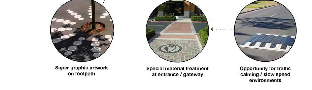
48 Figure 18 - Shorland Park Opportunities 11.1 Urban Design In addition to the urban design consideration discussed there are a number of opportunities that fell outside the scope of the brief yet would improve the quality of the design proposal. These include: Increase parking provisions surrounding the business zone to free up parking adjacent to shops for other uses such as public space enhancements. Parking numbers could be increased by extending angle parking down adjacent side streets, and enabling parking in the median strip down Derwent St. Due to cost constraints there is likely to be surplus road area along the Parade i.e. where parking has been removed. These areas could be better utilised through adding footpath extensions that create space for public amenity; or more planting and vegetation. Full redesign of the business zone public space including enhancements such as a new public square, commissioned artwork and play elements, and higher quality material finishes than currently proposed in the specification 11.2 Dee Street Intersection The Dee Street roundabout has been one of the most controversial parts of the current scheme. The recommendation from the Transport and Urban Development Committee in February 2015 was to remove the roundabout and replace it with the following layout. 46

49 Figure 19 - Dee Street Roundabout Discussion notes from the Island Bay Cycleway Working Group meetings June 2015 summarised: Retaining the roundabout will provide an inconsistent level of service for people on bikes and a possible increase in safety risk primarily due to the need for cyclists to merge with traffic in order to negotiate the intersection. This gap in level of service is likely to hamper uptake by the interested and concerned people who we are designing for. Removing the roundabout provided an opportunity to construct a Zebra crossing immediately south of the intersection, retaining the roundabout as recommended by the working party will not improve pedestrian connections. The working group resolved to retain the Dee Street roundabout, and that a combination of lanes and sharrows will be used to be consistent with the markings in the town centre. The roundabout was originally installed in 2005 due to concern about southbound vehicle speeds. In the nine years prior to the roundabout, there were no relevant injury crashes recorded. Since 2005, there has been three injury crashes, including a car versus cyclist crash. Injury crash rates for cyclists at roundabouts are typically higher than at other intersection types. There is an opportunity to revisit the Dee Street roundabout and investigate a design option similar to that recommended by the Transport and Urban Development Committee in February A provisional sum for intersection improvements at Dee Street has been included in the rough order cost estimates for all concept options, 11.3 On-Street Parking The effects of the design options reducing on-street parking are likely to be controversial, particularly in the business area. Survey results show that a large number of vehicles observed using unrestricted parking spaces belong to commuters. Overall around 65% of long stay vehicles during the week are commuters while compared to the 58% in the weekend. If all of these commuters are parked at the same time, non-residents will occupy around half of the unrestricted parks provided for both the weekday and weekend. Provision of residents only parking in places along The Parade, to address issues with people parking all day after catching the bus to the CBD could be considered by Council. 47
BUSINESS ZONE - OPTION 400 (Western footpath) Have your say. Love the Bay Delivering on the Cycleway
 Have your say. Love the Bay Delivering on the Cycleway") BUSINESS ZONE - OPTION 400 (Western footpath) Have your say Love the Bay Delivering on the Cycleway Consultation open from 31 July to 13 August 2017 1 Introduction After the Love the Bay community-based
BUSINESS ZONE - OPTION 400 (Western footpath) Have your say Love the Bay Delivering on the Cycleway Consultation open from 31 July to 13 August 2017 1 Introduction After the Love the Bay community-based
Seek the Board s approval for the Donald Place kerb and channel renewal to progress to final design, tender and construction; and
 3. DONALD PLACE - KERB AND CHANNEL RENEWAL General Manager responsible: General Manager City Environment Officer responsible: Transport and City Streets Manager Author: Michelle Flanagan, Streets Capital
Item 3.1 Attachment 1
 Island Bay Cycleway-Working Party Report Purpose 1. To report on the outcomes of the Island Bay Cycleway community working party. Summary 2. At its 30 April 2015 meeting, Council agreed that a working
Port Macquarie-Hastings Pedestrian Access and Mobility Plan. Working Paper COMMUNITY ENGAGEMENT
 Port Macquarie-Hastings Pedestrian Access and Mobility Plan Working Paper COMMUNITY ENGAGEMENT December 2014 Table of Contents Table of Contents... 2 1 Introduction... 3 2 Submissions... 3 2.1 Stakeholder
Queen s Circus Roundabout
 Stage 2 Road Safety Audit Ref: 1128-RSA-01 Prepared for: Steer Davies Gleave By: Capital Traffic Prepared by: Checked by: Approved by: Andy Haunton, Audit Team Leader Jonathan Thompson, Audit Team Member
HEAD OF ECONOMIC PROMOTION AND PLANNING Nathan Spilsted, Senior Planning Officer Tel:
 7. TRAVELLER SITES ALLOCATIONS DOCUMENT REPORT OF: Contact Officer: Wards Affected: Key Decision: Report to: HEAD OF ECONOMIC PROMOTION AND PLANNING Nathan Spilsted, Senior Planning Officer Email: nathan.spilsted@midsussex.gov.uk
Longmont to Boulder Regional Trail Jay Road Connection DRAFT FINAL REPORT
 Longmont to Boulder Regional Trail Jay Road Connection DRAFT FINAL REPORT December 2018 Project Summary Boulder County, Colorado, in partnership with the City of Boulder, is evaluating options for multi-use
Commissioning Director - Environment
 Finchley and Golders Green Area Committee 27 April 2017 Title Report of Wards Status Urgent Key Enclosures Summers Lane,N12 Request for Pedestrian Improvements Commissioning Director - Environment Woodhouse
PSP 75 Lancefield Road. Northern Jacksons Creek Crossing Supplementary Information
 PSP 75 Lancefield Road Northern Jacksons Creek Crossing Supplementary Information September 2017 The northern crossing of Jacksons Creek proposed within the Lancefield Road PSP is a key part of the ultimate
SANDY BAY RETAIL PRECINCT STREETSCAPE REVITALISATION - PALM TREES AND BANNER POLES - RESPONSE TO PETITION
 Page 41 REPORT TITLE: SANDY BAY RETAIL PRECINCT STREETSCAPE REVITALISATION - PALM TREES AND BANNER POLES - RESPONSE TO PETITION REPORT PROVIDED BY: Road Services Engineer Director City Infrastructure 1.
POST CONSTRUCTION ROAD SAFETY AUDIT. Island Bay Cycleway
 POST CONSTRUCTION ROAD SAFETY AUDIT Island Bay Cycleway Prepared for Wellington City Council 11 May 2016 This document has been prepared for the benefit of Wellington City Council. No liability is accepted
PART VIII APPLICATION FOR REVISED SOUTH SIDE TRAFFIC MANAGEMENT WORKS TO FACILITATE LUAS BXD PLANNING REPORT ROADS & TRAFFIC DEPARTMENT
 PART VIII APPLICATION FOR REVISED SOUTH SIDE TRAFFIC MANAGEMENT WORKS TO FACILITATE LUAS BXD PLANNING REPORT ROADS & TRAFFIC DEPARTMENT NOVEMBER 2012 1.0 INTRODUCTION This report has been prepared in support
Proposals for the Harrogate Road / New Line Junction Improvement Scheme. August / September Supported by:
 Proposals for the Harrogate / New Line Junction Improvement Scheme August / September 2016 Supported by: Introduction Key Benefits Proposals are currently being developed for changes to the junction of
Report to: Greater Cambridge Partnership Joint Assembly 18 January A10 Foxton level crossing bypass and travel hub
 Report to: Greater Cambridge Partnership Joint Assembly 18 January 2018 Lead officer: Chris Tunstall GCP Director of Transport A10 Foxton level crossing bypass and travel hub 1. Purpose 1.1 The list of
A Response to: Belfast On The Move Transport Masterplan for Belfast City Centre, Sustainable Transport Enabling Measures
 West Belfast Partnership 218-226 Falls Road Belfast BT12 6AH T: 02890809202 A Response to: Belfast On The Move Transport Masterplan for Belfast City Centre, Sustainable Transport Enabling Measures Issued
Wellington $312 $49 $456 OVERVIEW WELLINGTON REGIONAL SUMMARY
 National Land Transport Programme 2015 18 Wellington WELLINGTON REGIONAL SUMMARY OVERVIEW The Wellington region is made up of a number of cities, urban areas and supporting rural hinterland. The city is
London Borough of Barnet Traffic & Development Design Team
 London Borough of Barnet Traffic & Development Design Team AERODROME ROAD PEDESTRIAN FACILITY AND BUS STOP INTRODUCTION FEASIBILITY REPORT Job Number: 60668 Doc Ref: S106/12-13/60668 Author: Manoj Kalair
Roundhouse Way Transport Interchange (Part of NATS City Centre Package)
") Roundhouse Way Transport Interchange (Part of NATS City Centre Package) 15/16 16/17 17/18 18/19 19/20 Total TOTAL COST Roundhouse Way Transport Interchange 0.5m 0.5m FUNDING CIL 0.05m 0.05m Growth Deal
Roundhouse Way Transport Interchange (Part of NATS City Centre Package) 15/16 16/17 17/18 18/19 19/20 Total TOTAL COST Roundhouse Way Transport Interchange 0.5m 0.5m FUNDING CIL 0.05m 0.05m Growth Deal
Agenda Item 5: Rail East Midlands Rail Franchise Consultation
 Strategic Transport Forum 15 th September 2017 Agenda Item 5: Rail East Midlands Rail Franchise Consultation Recommendation: It is recommended that the Forum agree (subject to any amendments agreed by
WELLINGTON $422 MILLION $614 MILLION $83 MILLION 22% SPEND $1.9 BILLION
 WELLINGTON WELLINGTON $1.9 BILLION FORECAST TOTAL WELLINGTON INVESTMENT The Wellington region s transport challenges are dominated by the region s concentration of population in the metropolitan cities,
John Betts School Crossing Review
 John Betts School Crossing Review Paddenswick Road London Borough of Hammersmith & Fulham August 2015 DOCUMENT CONTROL Project Centre has prepared this report in accordance with the instructions from the
PERTH-ADELAIDE CORRIDOR STRATEGY
 INTRODUCTION The Royal Automobile Association of SA Inc (RAA), the State s principal advocate for motorists on a broad range of motoring-related issues, represents the views of more than 560,000 South
Committee. Presentation Outline
 CW-33-15 11/9/2015 Community and Corporate Services Committee November 10, 2015 1 Presentation Outline Background Vision and Objectives Study Process and Timeline Public and Stakeholder Engagement Organization
1 INFORMATION REQUIREMENTS
 1 INFORMATION REQUIREMENTS 1.1 BACKGROUND 2 1.2 WHAT IS THE DISTRICT PLAN 3 1.3 DISTRICT PLAN STRUCTURE 4 1.4 HOW TO USE THE DISTRICT PLAN 5 1.5 STRATEGIC FRAMEWORK 6 Whanganui District Plan (15 January
Christchurch City Council. Major Cycleways. Activity Management Plan. Long Term Plan
 Major Cycleways Activity Management Plan Long Term Plan 2015 2025 3 December 2014 Quality Assurance Statement Christchurch City Council Civic Offices 53 Hereford Street PO Box 73015 Christchurch 8154 Tel:
LINCOLNSHIRE PARKING POLICY DRAFT
 LINCOLNSHIRE PARKING POLICY DRAFT Draft 23/05/11 1 of 7 1. Introduction This document sets out and explains the County Councils Parking Policy. The County Council is planning to apply for powers to take
Member-led Review of Cycling Infrastructure
 Member-led Review of Cycling Infrastructure Survey Results: Hills Road, Cambridge June 2017 0 cambridgeshire.gov.uk Contents 1. Introduction... 3 2. About you... 3 2.1 Age... 3 2.2 What is your gender?...
7. CONSULTATION ON THE TRAVELLER SITES ALLOCATIONS DOCUMENT
 7. CONSULTATION ON THE TRAVELLER SITES ALLOCATIONS DOCUMENT REPORT OF: HEAD OF ECONOMIC PROMOTION AND PLANNING Contact Officer: Nathan Spilsted, Senior Planning Officer Email: nathan.splistead@midsussex.gov.uk
Gold Coast. Rapid Transit. Chapter twelve Social impact. Chapter content
 Gold Coast Rapid Transit Chapter twelve Social impact Chapter content Social impact assessment process...235 Existing community profile...237 Consultation...238 Social impacts and mitigation strategies...239
LYNDHURST NEW URBAN DEVELOPMENT AREA STRUCTURE PLAN. Lyndhurst New Urban Development Area Structure Plan OUTCOMES AND PERFORMANCE STANDARDS
 APPENDIX 15.1-3 LYNDHURST NEW URBAN DEVELOPMENT AREA STRUCTURE PLAN Purpose of the Structure Plan Lyndhurst New Urban Development Area Structure Plan OUTCOMES AND PERFORMANCE STANDARDS LSP-P1 The District
Kilometres. Blacktown. Penrith. Parramatta. Liverpool Bankstown. Campbelltown
 0 5 10 15 20 Kilometres Penrith Blacktown Parramatta Liverpool Bankstown Campbelltown accessibility outcomes Legend Outcomes targeted in Western Sydney are: public transport that is accessible throughout
Glasgow Street Traffic Review
 Glasgow Street Traffic Review Recommendation That the Standing Policy Committee on Transportation recommend to City Council: 1. That the Administration proceed with removing the pinch points installed
Part four. In this part you will find: The next steps to deliver the master plan
 Part four NEXT STEPS In this part you will find: The next steps to deliver the master plan 6. How COULD the Master Plan be delivered? There are a number of steps required to take the proposals in the master
Next Generation Cycleway Design. Improving connectivity and cycling behaviours through design
 Next Generation Cycleway Design Improving connectivity and cycling behaviours through design Safe segregation between Place Users to offer improved safety and a defined space for each user group Elevated
Council Briefing Minutes
 1 Council Briefing Minutes Date: Time: Location: In Attendance Not in Attendance Wednesday, 24 October, 2018 2:30 p.m. Council Chamber Forum North, Rust Avenue Whangarei Cr Greg Innes (Chairperson) Cr
NATIONAL AIRSPACE POLICY OF NEW ZEALAND
 NATIONAL AIRSPACE POLICY OF NEW ZEALAND APRIL 2012 FOREWORD TO NATIONAL AIRSPACE POLICY STATEMENT When the government issued Connecting New Zealand, its policy direction for transport in August 2011, one
Macleod Trail Corridor Study. Welcome. Macleod Trail Corridor Study Open House. Presentation of Proposed Design Concepts
 Macleod Trail Corridor Study Welcome Macleod Trail Corridor Study Open House Presentation of Proposed Design Concepts Study Purpose Develop a corridor plan for Macleod Trail that aligns with The City s:
Traffic Calming Measures
 REPUBLIC OF GHANA MINISTRY OF TRANSPORTATION Ghana Highway Authority Road Safety and Environment Division Traffic Calming Measures Design Guideline Version 1 / July 2007 Traffic Calming Measures Page 2
Upper Clutha Transport Report
 Upper Clutha Transport Report Shaping our Future Vision for the Upper Clutha incorporating Land, Air and Water Transport: The Queenstown Lakes District has a functional, innovative, integrated, multi-modal
Launceston City Council. Kings Meadows Traffic Management Report for Public Consultation
 Launceston City Council Kings Meadows Traffic Management Report for Public Consultation November 2013 This report: has been prepared by GHD for Launceston City Council and may only be used and relied on
Terms of Reference: Introduction
 Terms of Reference: Assessment of airport-airline engagement on the appropriate scope, design and cost of new runway capacity; and Support in analysing technical responses to the Government s draft NPS
TAG Guidance Notes on responding to the Civil Aviation Authority s consultation on its Five Year Strategy
 TAG Guidance Notes on responding to the Civil Aviation Authority s consultation on its Five Year Strategy 1. Introduction (Deadline for consultation responses is 19 February 2016) The CAA is currently
GISBORNE DISTRICT COUNCIL BUSINESS CASE PROPOSAL. Eastland Port Access. Pedestrian Safety Rakaiatane Rd. Page 1 of 4
 GISBORNE DISTRICT COUNCIL BUSINESS CASE PROPOSAL Eastland Port Access Pedestrian Safety Rakaiatane Rd Page 1 of 4 Introduction This proposal has been developed by Gisborne District Council (GDC) to provide
Finchley and Golders Green Area Committee 27 April 2017
 Finchley and Golders Green Area Committee 27 April 2017 Title Report of Wards Status Urgent Key Enclosures Officer Contact Details Junction of Regents Park Road / Tillingbourne Gardens, N3 Commissioning
CHRISTCHURCH MOTORWAYS. Project Summary Statement February 2010
 CHRISTCHURCH MOTORWAYS Project Summary Statement February 2010 Table of Contents 1. Purpose of Document 2. Strategic Context 3. Benefits 4. Project Scope and Economics 5. Implementation Plan 1 ROADS OF
Member-led Review of Cycling Infrastructure
 Member-led Review of Cycling Infrastructure Survey Results: A1 Cambridge to Royston June 17 cambridgeshire.gov.uk Contents 1. Introduction... 3. About you... 3.1 Age... 3. What is your gender?... 3.3 Do
Date: 11 th January, From: Plaistow & Ifold Parish Neighbourhood Plan - Steering Group. Plaistow & Ifold Parish Council
 Date: 11 th January, 2017 From: Plaistow & Ifold Parish Neighbourhood Plan - Steering Group To: Plaistow & Ifold Parish Council Re: Neighbourhood Plan Report to Parish Council Meeting 17 Jan 2017 The Steering
LINCOLNSHIRE PARKING POLICY DRAFT
 LINCOLNSHIRE PARKING POLICY DRAFT Draft 17/11/11 1 of 7 1. Introduction This document sets out and explains the County Councils Parking Policy. The County Council is planning to apply for powers to take
POLICE AND FIRE & RESCUE SCRUTINY SUB-COMMITTEE. Consultation, Annual Review of Policing 2017/18 by Scottish Police Authority (SPA)
") To: POLICE AND FIRE & RESCUE SCRUTINY SUB-COMMITTEE On: 22 MAY 2018 Report by: DIRECTOR OF ENVIRONMENT & COMMUNITIES Heading: Consultation, Annual Review of Policing 2017/18 by Scottish Police Authority
To: POLICE AND FIRE & RESCUE SCRUTINY SUB-COMMITTEE On: 22 MAY 2018 Report by: DIRECTOR OF ENVIRONMENT & COMMUNITIES Heading: Consultation, Annual Review of Policing 2017/18 by Scottish Police Authority
Gold Coast. Rapid Transit. Chapter content. Chapter four Route selection and staging
 Chapter four Route selection and staging Gold Coast Rapid Transit Chapter four Route selection and staging Chapter content Route selection...73 Section one: Helensvale to Griffith University...74 Section
BACKCOUNTRY TRAIL FLOOD REHABILITATION PROGRAM
 BACKCOUNTRY TRAIL FLOOD REHABILITATION PROGRAM Backcountry Trail Flood Rehabilitation A June 2013 Flood Recovery Program Summary In June 2013, parts of Southern Alberta were devastated from significant
Member-led Review of Cycling Infrastructure
 Member-led Review of Cycling Infrastructure Survey Results: Huntingdon Road, Cambridge June 217 cambridgeshire.gov.uk Contents 1. Introduction... 3 2. About you... 3 2.1 Age... 3 2.2 What is your gender?...
Appendix 6 Fulbourn Greenway Review
 Appendix 6 Fulbourn Greenway Review Nigel Brigham & Associates A report for 1 Introduction This report is based on fieldwork carried out in 2016 to review the Greenway network around Cambridge as shown
CONGESTION MONITORING THE NEW ZEALAND EXPERIENCE. By Mike Curran, Manager Strategic Policy, Transit New Zealand
 CONGESTION MONITORING THE NEW ZEALAND EXPERIENCE 26 th Australasian Transport Research Forum Wellington New Zealand 1-3 October 2003 By, Manager Strategic Policy, Transit New Zealand Abstract New Zealand
Proposal for gypsy and traveller accommodation on land at Lower Hollow Copse (Pot Common), Copthorne. Statement of Community Involvement
, Copthorne. Statement of Community Involvement") Proposal for gypsy and traveller accommodation on land at Lower Hollow Copse (Pot Common), Copthorne Statement of Community Involvement Prepared by WYG Environment Planning Transport Ltd on behalf of the
Proposal for gypsy and traveller accommodation on land at Lower Hollow Copse (Pot Common), Copthorne Statement of Community Involvement Prepared by WYG Environment Planning Transport Ltd on behalf of the
3. COLTA / HUGA CONNECTIONS - PRELIMINARY
 9 3. COLTA / HUGA CONNECTIONS - PRELIMINARY 3.1 COLTA The Chain of Lakes Trail Association (COLTA) trail, formerly identified as the Chester Spur Line, was completed and opened for use in June 2011. The
Saighton Camp, Chester. Technical Note: Impact of Boughton Heath S278 Works upon the operation of the Local Highway Network
 Technical Note: Impact of Boughton Heath S278 Works July 2013 SAIGHTON CAMP CHESTER COMMERCIAL ESTATES GROUP TECHNICAL NOTE: IMPACT OF BOUGHTON HEATH S278 WORKS UPON THE OPERATION OF THE LOCAL HIGHWAY
Performance Criteria for Assessing Airport Expansion Alternatives for the London Region
 Performance Criteria for Assessing Airport Expansion Alternatives for the London Region Jagoda Egeland International Transport Forum at the OECD TRB Annual Meeting 836 - Measuring Aviation System Performance:
Provincial Railway Technical Standards
 GENERAL: INDEX: The standards and requirements listed in this document are intended for use on provincially regulated railway public grade crossings. These standards are considered the minimum requirements
MEETING MINUTES Page 1 of 5
 Page 1 of 5 50178.000 May 26, 2009 PROJECT PROJECT NO. MEETING DATE ISSUE DATE Citizens Advisory Committee Meeting MEETING LOCATION MEETING PURPOSE Amy Eckland ISSUED BY SIGNATURE PARTICIPANT See attached
Schedule of Planning Applications Committee Date: 23 May Reference: 06/18/0064/F Great Yarmouth Officer: Mr J Beck Expiry Date:
 Schedule of Planning Applications Committee Date: 23 May 2018 Reference: 06/18/0064/F Great Yarmouth Officer: Mr J Beck Expiry Date: 24-04-2018 Applicant: Proposal: Site: Mr Mavroudis Clear weather hoardings
Land Management Summary
 photo credit: ANGAIR Anglesea Heath Land Management Summary The Anglesea Heath (6,501 ha) was incorporated into the Great Otway National Park in January 2018. This provides an opportunity to consider the
REAUTHORISATION OF THE ALLIANCE BETWEEN AIR NEW ZEALAND AND CATHAY PACIFIC
 Chair Cabinet Economic Growth and Infrastructure Committee Office of the Minister of Transport REAUTHORISATION OF THE ALLIANCE BETWEEN AIR NEW ZEALAND AND CATHAY PACIFIC Proposal 1. I propose that the
PERTH AND KINROSS COUNCIL. Housing and Health Committee. 25 May Perth and Kinross Local Housing Strategy
 PERTH AND KINROSS COUNCIL 7 16/234 Housing and Health Committee 25 May 2016 Perth and Kinross Local Housing Strategy 2016-2021 Report by Director (Housing and Social Work) PURPOSE OF REPORT This report
Movement Strategy. November On behalf of Barton Oxford LLP
 Movement Strategy November 2014 On behalf of Barton Oxford LLP BARTON PARK, OXFORD. Movement Strategy 17/11/2014 Quality Management Issue/revision Issue 1 Revision 1 Revision 2 Revision 3 Remarks Date
AS/NZS :2015. Lighting for roads and public spaces AS/NZS :2015. Part 4: Lighting of pedestrian crossings. Australian/New Zealand Standard
 Australian/New Zealand Standard AS/NZS 1158.4:2015 Lighting for roads and public spaces Part 4: Lighting of pedestrian crossings Superseding AS/NZS 1158.4:2009 AS/NZS 1158.4:2015 AS/NZS 1158.4:2015 This
Commissioning Director - Environment. Officer Contact Details Jane Shipman;
 Chipping Barnet Area Committee 6 July 2016 Title Report of Wards Status Urgent Key Enclosures The Avenue Zebra crossing and pedestrian improvements Commissioning Director - Environment Chipping Barnet
Frequently Asked Questions on the Route 29 Solutions Improvements Projects
 Frequently Asked Questions on the Route 29 Solutions Improvements Projects Background What are the Route 29 Solutions improvement projects? These projects include the Route 29/250 Interchange ( Best Buy
1. Case Study Area and Character Sections
 ARAGO STREET 1. Case Study Area and Character Sections Case Study Area Calle Aragó is an important streets in the centre of Barcelona. The street belongs to the Eixample district. The origins of Barcelona
This report recommends that Council approve concept plan 021-CP-001-B (see Attachment 1), for detailed design and delivery this financial year.
, for detailed design and delivery this financial year.") FPOL1711-9 HILTON TOWN CENTRE PROJECT SCOPE Meeting Date: 0 Responsible Officer: Manager Infrastructure Engineering Decision Making Authority: Council Agenda Attachments: 1. Concept Plan no 021-CP-001-B
FPOL1711-9 HILTON TOWN CENTRE PROJECT SCOPE Meeting Date: 0 Responsible Officer: Manager Infrastructure Engineering Decision Making Authority: Council Agenda Attachments: 1. Concept Plan no 021-CP-001-B
A summary report on what the community told us
 DECEMBER 2015 A summary report on what the community told us During August and September 2015, UrbanGrowth NSW in partnership with Newcastle City Council ran the Revitalising Newcastle community engagement
URBAN DESIGN REPORT. Proposed Residential Development, Old Church Road, Caledon East
 Proposed Residential Development, Old Church Road, Caledon East TABLE CONTENTS: 1.0 DEVELOPMENT 1.1 Introduction-Analysis of Guiding Principles and Documents 1.2 Community Design and Architectural Design
Draft City Centre Transport Proposals
 Draft City Centre Transport Proposals Introduction This draft position paper provides an overview of the current City Centre transport issues, including concepts of the possible future City Centre transport
CITY OF MELBOURNE 10 Year Financial Plan People s Panel Report. 8 November 2014
 CITY OF MELBOURNE 10 Year Financial Plan People s Panel Report 8 November 2014 The Panel s Decision Making Principles 1. SMART (Specific, Measurable, Achievable, Realistic, Timely) 2. Sustainable 3. Forward
Blueways: Rivers, lakes, or streams with public access for recreation that includes fishing, nature observation, and opportunities for boating.
 Parks, Open Space and Trails PRINCE WILLIAM COUNTY 2008 COMPREHENSIVE PLAN TRAILS PLAN CONTENTS The components of the trails plan are: Intent Definitions Goals, Policies, and Action Strategies Trails Map
SUMMER VILLAGE OF SILVER SANDS. Municipal Development Plan
 SUMMER VILLAGE OF SILVER SANDS Municipal Development Plan Bylaw 253-2014 Adopted August 22, 2014 Summer Village of Silver Sands Municipal Development Plan Bylaw No. 253-2014 Page 2 1 INTRODUCTION 1.1 SETTING
As part of our transport vision, Leeds City Council, working with the West Yorkshire Combined Authority and Leeds Bradford Airport Company, is
 As part of our transport vision, Leeds City Council, working with the West Yorkshire Combined Authority and Leeds Bradford Airport Company, is considering options for improving surface access and connectivity
Environment Committee 24 September 2015
 Environment Committee 24 September 2015 Title Enforcement of Single Yellow Lines on Bank Holidays Report of Commissioning Director - Environment Wards All Status Public Urgent No Enclosures Key No Appendix
Response to the London Heathrow Airport Expansion Public Consultation
 Response to the London Heathrow Airport Expansion Public Consultation Summary This report sets out the response to the Heathrow Airport s consultation on airport expansion and airspace change. The consultation
5 Rail demand in Western Sydney
 5 Rail demand in Western Sydney About this chapter To better understand where new or enhanced rail services are needed, this chapter presents an overview of the existing and future demand on the rail network
N4 Carrick-on-Shannon to Dromod Road Project. 2.1 Introduction
 Chapter 2 Need for the Scheme 2.1 Introduction The National Primary Route N4, Dublin to Sligo is a strategic corridor from Dublin to the northwest and border counties (See RCSR 101 in Volume 2). The National
COMMISSION IMPLEMENTING REGULATION (EU)
") 18.10.2011 Official Journal of the European Union L 271/15 COMMISSION IMPLEMENTING REGULATION (EU) No 1034/2011 of 17 October 2011 on safety oversight in air traffic management and air navigation services
18.10.2011 Official Journal of the European Union L 271/15 COMMISSION IMPLEMENTING REGULATION (EU) No 1034/2011 of 17 October 2011 on safety oversight in air traffic management and air navigation services
SAN FRANCISCO MUNICIPAL TRANSPORTATION AGENCY
 THIS PRINT COVERS CALENDAR ITEM NO. : 10.4 DIVISION: Sustainable Streets BRIEF DESCRIPTION: SAN FRANCISCO MUNICIPAL TRANSPORTATION AGENCY Approving various parking and traffic modifications associated
20mph Speed Limit Zones
 Traffic Advisory Leaflet 7/91 May 1991 20mph Speed Limit Zones Summary This leaflet illustrates the main steps in the procedures for the implementation of 20mph zones. It provides brief details on: the
PERTH AND KINROSS COUNCIL. 22 June 2016 DEVELOPING THE CULTURAL OFFER IN PERTH AND KINROSS UPDATE AND NEXT STEPS
 PERTH AND KINROSS COUNCIL 8 16/278 22 June 2016 DEVELOPING THE CULTURAL OFFER IN PERTH AND KINROSS UPDATE AND NEXT STEPS Report by Senior Depute Chief Executive (Equality, Community Planning & Public Service
Guide for Permits Development adjacent to Provincial Highways
 Guide for Permits Development adjacent to Provincial Highways Engineering & Operations Division Highway Planning and Design Branch January 2019 TABLE OF CONTENTS 1 Introduction... 1 1.1 The Traffic and
A Master Plan is one of the most important documents that can be prepared by an Airport.
 The Master Plan A Master Plan is one of the most important documents that can be prepared by an Airport. A Master Plan is a visionary and a strategic document detailing planning initiatives for the Airport
The following resource management issues have been identified as significant in the Art Deco Quarter:
 Chapter 59 ART DECO QUARTER SIGNS INTRODUCTION The Art Deco Quarter is Napier City s foremost shopping precinct as well as being the most important public place and pedestrian area. As such there are many
Rangitīkei District Council
 Rangitīkei District Council Assets and Infrastructure Committee Meeting Agenda Thursday 9 August 2018 9:30 AM Contents 1 Welcome...3 2 Council Prayer...3 3 Apologies/leave of Absence...3 4 Members conflict
03 Opportunities and Strategies Union Canal Study 17
 03 Opportunities and Strategies 17015 Union Canal Study 17 Introduction This chapter summarises the issues, opportunities for improvement and proposed strategy outcomes of the study of the towpath. The
Sunshine Coast Airport Master Plan September 2007
 Sunshine Coast Airport Master Plan September 2007 Contents CONTENTS... I ACKNOWLEDGEMENT... II DISCLAIMER... III 1 EXECUTIVE SUMMARY...IV 1 INTRODUCTION... 1 2 AVIATION DEMAND FORECAST... 5 3 AIRCRAFT
Date 24/10/2011. Date 04/11/2011. Date 25/10/2011. Date 10/11/2011. Date 25/10/2011. Date 25/10/2011. Date 10/11/2011.
 DELEGATED POWERS REPORT NO. 1489 SUBJECT: Traffic Signal Review, Junction of Oakleigh Road North and the A1000 Control sheet All of the following actions MUST be completed at each stage of the process
CAA consultation on its Environmental Programme
 CAA consultation on its Environmental Programme Response from the Aviation Environment Federation 15.4.14 The Aviation Environment Federation (AEF) is the principal UK NGO concerned exclusively with the
Guildford Borough Transport Strategy 2017, Topic Paper: Transport, June 2017 (accompanying Local Plan 2017) Local Plan Transport Strategy 2017
 Local Plan Transport Strategy 2017") Guildford Society Transport Group Position Paper August 2017 Based on submissions in response to the June/July 2017 Local Plan consultation including material presented to Drop-in Session 15 July 2017.
Guildford Society Transport Group Position Paper August 2017 Based on submissions in response to the June/July 2017 Local Plan consultation including material presented to Drop-in Session 15 July 2017.
COMMISSION OF THE EUROPEAN COMMUNITIES. Draft. COMMISSION REGULATION (EU) No /2010
 No /2010") COMMISSION OF THE EUROPEAN COMMUNITIES Brussels, XXX Draft COMMISSION REGULATION (EU) No /2010 of [ ] on safety oversight in air traffic management and air navigation services (Text with EEA relevance)
COMMISSION OF THE EUROPEAN COMMUNITIES Brussels, XXX Draft COMMISSION REGULATION (EU) No /2010 of [ ] on safety oversight in air traffic management and air navigation services (Text with EEA relevance)
FASI(N) IoM/Antrim Systemisation Airspace Change Decision
 IoM/Antrim Systemisation Airspace Change Decision") Safety and Airspace Regulation Group FASI(N) IoM/Antrim Systemisation Airspace Change Decision CAP 1584 Contents Published by the Civil Aviation Authority, August 2017 Civil Aviation Authority, Aviation
Safety and Airspace Regulation Group FASI(N) IoM/Antrim Systemisation Airspace Change Decision CAP 1584 Contents Published by the Civil Aviation Authority, August 2017 Civil Aviation Authority, Aviation
The implementation of this Master Plan will be undertaken in logical stages to meet passenger and workforce demands.
 The implementation of this Master Plan will be undertaken in logical stages to meet passenger and workforce demands. Connecting People Building Opportunities 198 Brisbane Airport Corporation CHAPTER 10
Open Report on behalf of Richard Wills, Executive Director for Environment and Economy
 Agenda Item 7 Executive Open Report on behalf of Richard Wills, Executive Director for Environment and Economy Report to: Executive Date: 02 September 2014 Subject: Lincoln East West Link Road Phase 1
Major Scheme Business Case Summary Report for Programme Entry
 Paper A Heart of South West Local Transport Board Major Scheme Business Case Summary Report for Programme Entry M5 Junction 25, Taunton July 2016 1 SCHEME SUMMARY Scheme Name M5 Junction 25, Taunton Date
Northern Beaches Transport Action Plan
 Northern Beaches Transport Action Plan The NSW Government is taking action now to deliver transport improvements for the Northern Beaches, as well as planning for the future growth of the area. $633 million