This page intentionally left blank
|
|
|
- Laura Thornton
- 5 years ago
- Views:
Transcription
1
2 This page intentionally left blank
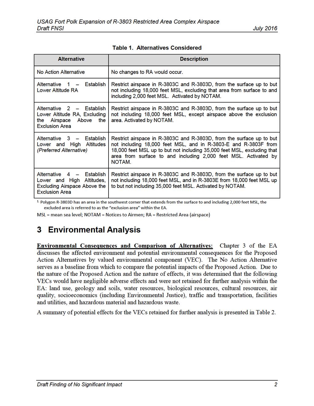
3 Draft FNSI July 2016 Introduction PRELIMINARY DRAFT FINDING OF NO SIGNIFICANT IMPACT U.S. ARMY GARRISON FORT POLK EXPANSION OF R-3803 RESTRICTED AREA COMPLEX AIRSPACE The Department of the Army (Army) has prepared an Environmental Assessment (EA) to evaluate the environmental, cultural, and socioeconomic impacts of expanding restricted area (RA) airspace over recently acquired lands at Fort Polk, Louisiana. The National Environmental Policy Act of 1969 (NEPA) requires all Federal agencies to give appropriate consideration to potential environmental effects of proposed major actions in planning and decision-making. In accordance with both Council on Environmental Quality (CEQ) and Army National Environmental Policy Act (NEPA) regulations (40 Code of Federal Regulations [CFR] and 32 CFR , respectively), this Draft Finding of No Significant Impact (FNSI) hereby incorporates the entire EA by reference. 1 Purpose and Need for the Proposed Action The purpose of the Proposed Action is to enable the Army to conduct the necessary type, level, duration, and intensity of live-fire and other military training exercises for the combat units assigned to Fort Polk and the Rotational Training Units at the Joint Readiness Training Center (JRTC). To be operationally effective in the combat environment, Soldiers must acquire and sustain the skills and experience to operate and maintain weapons. They must also train as they fight, incorporating into training the same munitions and equipment used in combat. Expansion of the R-3803 Restricted Area (RA) complex airspace (R-3803) overlying recently acquired land is required to better achieve combined arms teamwork and synchronization per recent Army doctrine. This includes allowing Combined Arms Live Fire Exercises (CALFEX) training, and utilization of current ranges for larger weapon systems with higher trajectories fired into the existing Peason Ridge impact areas. 2 Description of the Proposed Action and Alternatives Chapter 2 of the EA presents a detailed discussion of the screening criteria used to develop alternatives, a description of alternatives considered, and alternatives considered but not brought forth to analysis. The Proposed Action is to request the Federal Aviation Administration (FAA) establish new RA overlying recently acquired land to conduct future training activities. Based on the screening criteria, the Army is considering four RA design alternatives along with a No Action Alternative to be carried forward for full analysis in this EA (see Table 1). Draft Finding of No Significant Impact 1
4
5
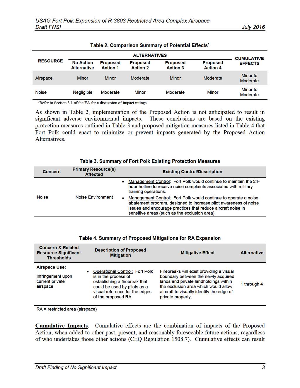
6 Draft FNSI July 2016 from actions occurring over a period of time that are minor when each is considered individually, but that are significant when viewed collectively. The cumulative impacts analysis considered activities within Peason Ridge, the newly acquired lands, and adjacent areas. Projects and activities with the potential for cumulative impacts when considered with the Proposed Action are generally limited to ongoing and potential future military training on the newly acquired lands that would require RA activation, as well as ongoing private and commercial airspace use. No large scale projects or actions were identified within the region surrounding Fort Polk, with a landscape historically devoted to timber harvesting and rural development. The primary impacts associated with the Proposed Action are associated with expansion of RA. This includes potential minor to moderate airspace use and noise environment impacts. As outlined in Table 2, minor to moderate cumulative adverse impacts are anticipated to these resources. Proposed Impact Reduction Measures: As demonstrated in Table 2, impacts resulting from the Proposed Action would be less than significant. Various measures have been identified within the EA analysis that could be undertaken by Fort Polk to minimize adverse effects. This includes continued implementation of existing operational and management controls (Table 3), and the adoption and implementation of proposed operational and management mitigations (Table 4). No other mitigation measures would be required. 4 Public Review and Comment The Army conducted a 30-day public scoping period beginning on November 22, 2015 and ending on December 21, 2015 during which time, input and comments were solicited from members of the public and other agencies. The EA/Draft FNSI was made available for a 30-day public review and comment period. Documents were also made available at local libraries and available online at the Fort Polk Environmental and Natural Resources Management Division website ( compliance/nepa.html). A Public Notice was also published in local newspapers. Draft Finding of No Significant Impact 4
7 Draft FNSI July Finding of No Significant Impact I have considered the results of the analysis in the EA, the comments received during the public comment period, and associated cumulative effects. Based on these factors, I have decided to proceed with Proposed Action Alternative 3. Implementation of the Proposed Action, along with specified measures identified above, will not have a significant impact on the quality of human life or natural environment. This analysis fulfills the requirements of the NEPA of 1969 as implemented by the CEQ regulations (40 CFR Parts ), as well as the requirements of the Environmental Analysis of Army Actions (32 CFR Part 651). Therefore, issuance of a FNSI is warranted and an Environmental Impact Statement is not necessary. Colonel David Athey Garrison Commander Date: Draft Finding of No Significant Impact 5
8 Draft FNSI July 2016 This Page Intentionally Left Blank Draft Finding of No Significant Impact 6
9 U.S. Army Garrison Fort Polk Expansion of R-3803 Restricted Area Complex Environmental Assessment [Placeholder] Approved By: Date: Colonel David Athey Garrison Commander Table of Contents i
10 This Page Intentionally Left Blank Table of Contents ii
11 Table of Contents 1 Purpose, Need, and Scope Background Army Mission Fort Polk Mission Joint Readiness Training Center Mission Location and Land Ownership Purpose and Need for the Proposed Action Purpose of the Proposed Action Need for the Proposed Action Decisions to be Made Scope of Environmental Analysis (Issues of Concern) Public and Agency Involvement Cooperating Agency Status Description of the Proposed Action and Alternatives Proposed Action CALFEX Training Space Requirements Essential training components of the CALFEX Restricted Area Requirements Screening Criteria Alternatives Considered No Action Alternative Proposed Action Alternative 1 Establish Lower Altitude Restricted Area Proposed Action Alternative 2 Establish Lower Altitude Restricted Area, Excluding the Airspace Above the Exclusion Area Proposed Action Alternative 3 Establish Lower and High Altitudes (Preferred Alternative) Proposed Action Alternative 4 Establish Lower and High Altitudes, Excluding the Airspace Above the Exclusion Area Alternatives Considered but Dismissed Establishment of RA Elsewhere on Fort Polk Lands Conduct Training at Other Active installations Conduct Simulated Training Table of Contents iii
12 3 Affected Environment and Environmental Consequences Impact Assessment Methodology Description of Baseline and Data Sources Approach for Analyzing Impacts Level of VEC Analysis Cumulative Effects Fort Polk Projects (Past, Present, and Reasonably Foreseeable) Other Agency (DoD and non-dod) and Other Public/Private Actions (Past, Present, and Reasonably Foreseeable) Airspace Affected Environment Overview Airspace Components Polk Approach Military Airfields Drop Zones Restricted Area Military Operations Area Air Traffic Control Assigned Airspace Federal Air Corridors Military Training Routes Civilian Airfields Airspace Use and Management Unmanned Aerial Systems Environmental Consequences No Action Alternative Supports Live-Fire Training Missions Supports Realistic Battlefield Situational Awareness Supports Air Training Missions Proposed Action Alternative 1 Establish Lower Altitude Restricted Area Supports Live-Fire Training Missions Supports Realistic Battlefield Situational Awareness Supports Air Training Missions Proposed Action Alternative 2 Establish Lower Altitude Restricted Area, Excluding the Airspace Above the Exclusion Area Supports Live-Fire Training Missions Supports Realistic Battlefield Situational Awareness Supports Air Training Missions Proposed Action Alternative 3 Establish Lower and High Altitudes (Preferred Alternative) Supports Live-Fire Training Missions Supports Realistic Battlefield Situational Awareness Supports Air Training Missions Table of Contents iv
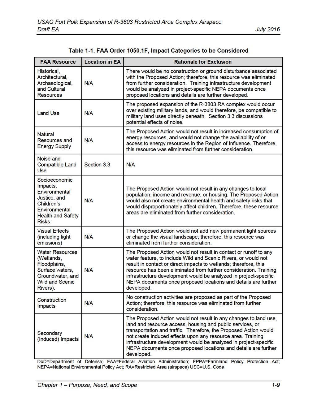
13 Proposed Action Alternative 4 Establish Lower and High Altitudes, Excluding the Airspace Above the Exclusion Area Supports Live-Fire Training Missions Supports Realistic Battlefield Situational Awareness Supports Air Training Missions Cumulative Impacts Noise Affected Environment Noise Overview Existing Noise Environment Environmental Consequences No Action Alternative Proposed Action Alternative 1 Establish Lower Altitude Restricted Area Proposed Action Alternative 2 Establish Lower Altitude Restricted Area, Excluding the Airspace Above the Exclusion Area Proposed Action Alternative 3 Establish Lower and High Altitudes (Preferred Alternative) Proposed Action Alternative 4 Establish Lower and High Altitudes, Excluding Airspace Above the Exclusion Area Cumulative Effects Summary of Environmental Consequences and Proposed Mitigation Acronyms References List of Preparers List of Tables Table 1-1. FAA Order F, Impact Categories to be Considered Table 2-1. Munitions Utilized during a CALFEX Table 2-2. Proposed Airspace Designations Table 2-3. Alternatives Considered Table VEC Assessment Criteria and Level of Assessment Table Summary of Airspace Impacts Table 3.2-2: Weapons Systems and Vertical Hazard Table Common Sounds and Their Levels Table Estimated Background Noise Levels Table Recommended Noise Limits for Land Use Planning Table Summary of Noise Impacts Table Estimated Day-night Sound Levels Table Maximum Sound Levels for Individual Aircraft Overflights Table 4-1. Comparison Summary of Potential Effects Table 4-2. Summary of Fort Polk Existing Resource Protection Measures Table 4-3. Summary of Proposed Mitigations for RA Expansion Table of Contents v
14 List of Figures Figure 1-1. Location Map Figure 2-1. Munitions Height Figure 2-2. Proposed RA Airspace Figure 2-3. Vertical View of Proposed RA Figure Sectional Showing Existing and Proposed RAs Figure Airspace Classification Diagram Figure ROI Airspace Vertical Diagram-A Figure ROI Airspace Vertical Diagram-B Figure Sectional Showing ROI and Airspace Components Figure Sectional Showing Polk Approach Area of Responsibility Figure Peason Ridge Flight Landing Strip Clearance Surfaces Figure Avelino DZ Survey Figure MOAs in the ROI Figure Hi-IFR Sectional with Proposed RA and ATCAAs (above 18,000 feet MSL) Figure Low-Level Victor Air Routes Figure High-Level J & Q Air Routes Figure Fort Polk Rotary Wing Air Routes Figure Fort Polk UAS Air Routes Figure Prairie Creek Airport Appendix A Appendix B Appendices Public Involvement Supporting Noise Documentation Table of Contents vi
15 IPR 1 Purpose, Need, and Scope 1.1 Background Army Mission The mission of the United States (U.S.) Army is to fight and win our nation s wars by providing prompt, sustained land dominance across the full range of military operations. Supporting the Army s mission has increasingly included supporting a broader spectrum of operations to include high intensity conflict, persistent low-level conflict, anti-terrorism operations and peacekeeping, stability and support operations. Rapidly delivering highly trained, adaptive, and professional forces is critical to achieving the Army s mission and supporting the nation s strategic and national defense mission and objectives. The Army is responsible for preparing the land forces necessary to effectively execute war efforts except as otherwise assigned. It is also responsible for maintaining the capability in conjunction with other armed forces of preserving the peace and security, and providing for the defense of the U.S., the Territories, Commonwealths, and possessions and any areas occupied by the U.S. It is responsible for supporting the national policies, implementing the national objectives, and overcoming any nations responsible for aggressive acts that imperil the peace and security of the U.S. Fort Polk Mission Fort Polk is home to the 3 rd Brigade Combat Team (BCT) 10 th Mountain Division; 5 th Aviation Battalion; 46 th Engineer Battalion; 519 th Military Police Battalion; 3 rd Battalion 353d Regiment; and 115 th Combat Support Hospital. Fort Polk supports the Joint Readiness Training Center s (JRTC s) advanced-level joint training for U.S. Army, Air Force, Navy, and Marine Units under conditions that simulate low-and mid-intensity conflicts. Fort Polk is a modern Installation that provides for well-being and quality of life for Soldiers, civilians, retirees, and their families. In addition, the Installation is one of the Army s 15 Power Projection Platforms (PPP), from which active duty and reserve component forces are trained, mobilized, validated, and deployed by air, rail, and sea to support global contingency operations. Joint Readiness Training Center Mission The mission of the U.S. Army is to fight and win our nation s wars by providing prompt, sustained land dominance across the full range of military operations. The primary mission of Fort Polk is to support and train home-stationed units while providing superior training to support the JRTC. The JRTC is a key component of the Army s Combat Training The primary mission of the Centers (CTCs) and training is focused on Army infantry, JRTC is to train BCTs for war. airborne, and air assault forces. The JRTC, in particular, provides forces across the Department of the Defense (DoD) (i.e., Army, Air Force, Navy, and Marines, etc.) with the opportunity to encounter and respond to a wide variety of mission scenarios. The JRTC allows the Army to train and develop highly proficient and cohesive units capable of conducting operations across the full spectrum of conflict. The JRTC accomplishes Chapter 1 Purpose, Need, and Scope 1-1
16 IPR its mission by providing superior training to the home station tenants and deployable combat units, while supporting at least 10 annual JRTC rotations. The JRTC is focused on improving unit readiness by providing an advanced level of training, as well as doctrine-based feedback for America s light infantry forces to develop Leaders and Soldiers and to prepare them for the challenges of full spectrum operations. JRTC conducts thorough, realistic, multi-echelon, joint and combined arms training so that Leaders can deal with complex situations and to create flexible, skilled Soldiers. Each JRTC rotation is comprised of different Army, Air Force, Navy and Marine units to receive advanced level joint training under unique, realistic, and constantly evolving battlefield scenarios. 1.2 Location and Land Ownership The JRTC and Fort Polk is located in west-central Louisiana in Natchitoches, Sabine and Vernon Parishes near the communities of Leesville and DeRidder, and about 15 miles east of the Texas- Louisiana border. Fort Polk is comprised of DoD and U.S. Forest Service (USFS) permitted lands totaling approximately 231,669 acres. DoD owned lands are divided into two primary land masses; Main Post and Peason Ridge. USFS permitted lands are divided into three separate land masses; the Intensive Use Area (IUA), the Limited Use Area (LUA) and the Special Limited Use Area (SLUA). Peason Ridge is comprised of approximately 75,000 acres in Vernon, Sabine, and Natchitoches Parishes, within the southern boundary. Peason Ridge is used to support both Army maneuver and live-fire training, but is not utilized for long-term housing of Army personnel or civilians, which occurs on the Main Post. In February, 2010 Fort Polk completed the JRTC and Fort Polk Land Acquisition Program (including purchase and lease) Final Environmental Impact Statement (FEIS), February 2010 (2010 Land Acquisition FEIS). The expansion of Fort Polk, up to 100,000 acres, was analyzed and the Installation received the authorization to actively pursue the land acquisition program. In fiscal year 2012, the U.S. Army Corps of Engineers (USACE) began closing on some of these new properties. To date approximately 42,000 acres of new training lands have been acquired and is reflected in the new acreage amount for Peason Ridge. Fort Polk utilizes an area of USFS lands north of Peason Ridge (i.e., the SLUA) known as Horse s Head, due to its configuration. The SLUA consists of approximately 12,380 acres and is available for limited training by the JRTC and Fort Polk. No live-fire activities are conducted in this area. Figure 1-1 illustrates the current boundary of Fort Polk, including those lands recently acquired. The Army has leased a parcel of land known as the yellow brick road to support the transport and convoys of units to and from Main Post to Peason Ridge. Airfield deployment/redeployment activities associated with JRTC rotations or mobilization take place on the JRTC Intermediate Staging Base (ISB) at the Alexandria Airport. This site can accept and support (landing, loading, and refueling) any combination of size and number of Air Force or civilian transport aircraft required under any operational scenario at Fort Polk. Chapter 1 Purpose, Need, and Scope 1-2
17
18 1.3 Purpose and Need for the Proposed Action Many Army units deploy abroad to support the full spectrum of potential operations, from waging the nation s wars to supporting peace and stability. While at home station, it is critical that they retain or develop those skills necessary to deploy and execute their respective missions. Effective training, carried out to a high doctrinal standard, is the cornerstone of operational success. High quality training prepares Soldiers for conditions and situations expected in combat, and it is essential to ensuring the success of the nation s strategic defense objectives, national security, and the safety of those who serve. Training exercises are major resources for keeping the Army ready to accomplish its missions. The majority of Soldier training and all collective training take place in units. In units, Soldiers build on basic tasks to attain skills not taught in initial entry training. Unit collective training develops effective combined arms teams consisting of fully integrated combat, combat support, combat service support, and Joint Special Operations Forces elements. Fort Polk recently acquired land adjacent to Peason Ridge to develop additional maneuver and live-fire training areas. To conduct future training activities, the Army s Proposed Action is to request the Federal Aviation Administration (FAA) establish new restricted area (RA) airspace overlying recently acquired land. Fort Polk is one of two Army CTCs with increasing and enduring requirements for realistic force-on-force and force-on-target exercises. In the future, the JRTC and Fort Polk proposes to conduct Combined Arms Live Fire Exercises (CALFEX) on the newly acquired training lands. The Proposed Action would also enhance the utilization of current ranges for larger weapon systems with higher trajectories. Although Fort Polk is not ready to develop infrastructure on the new training lands, training activities were addressed at a programmatic level in the (2010 Land Acquisition FEIS). Training infrastructure development would be analyzed in project-specific National Environmental Policy Act (NEPA) documents once proposed locations and details are further developed. Purpose of the Proposed Action The Proposed Action would enable the Army to conduct the necessary type, level, duration, and intensity of live-fire and other military training exercises for the combat units assigned to Fort Polk and the Rotational Training Units (RTUs) at JRTC. To be operationally effective in the combat environment, Soldiers must acquire and sustain the skills and experience to operate and maintain weapons. They must also train as they fight, incorporating into training the same munitions and equipment used in combat. Units must conduct live-fire training exercises to ensure they have rehearsed battle procedures and are prepared for wartime operations. Larger units, company- and battalion-level, must conduct CALFEXs to ensure proper integration of units in combat scenarios. These operations include offensive, defensive, stability, and support operations in particular battalion-level CALFEXs. Units undertaking these exercises will attain and maintain their combat readiness. Need for the Proposed Action The JRTC and Fort Polk must be prepared to execute the full spectrum of military operations in complex terrain. To achieve and maintain the combat skills appropriate for each Soldier in the force, training must replicate, as closely as possible, the conditions that would arise in expected combat situations. To ensure that Soldiers develop these skills and experience, the Army has Chapter 1 Purpose, Need, and Scope 1-4
19 developed standardized training requirements. It is imperative that every Soldier and unit meets each of its requirements. These standards are derived from the Army Doctrine Reference Publication (ADRP) 3-0, Unified Land Operations (Army 2012), which augments the unified land operations doctrine established in Army Doctrine Publication (ADP) 3-0. Army doctrine requires combined arms teamwork and synchronization. Units must train for wartime combined arms operations. Combined arms proficiency results from regular practice of combat missions and tasks in the live domain. It starts with developing individual skills. Individual skills, when combined and practiced, build unit proficiency from platoon through brigade task force. Expansion of the R-3803 Restricted Area (RA) complex airspace (R-3803) overlying recently acquired land is required to better achieve combined arms teamwork and synchronization per recent Army doctrine. 1.4 Decisions to be Made This EA considers the direct, indirect, and cumulative effects of the Proposed Action and the No Action Alternative. It was prepared in accordance with the NEPA of 1969 (42 United States Code [USC] 4321 et seq.), Council on Environmental Quality (CEQ) Regulations 40 Code of Federal Regulations (CFR) Parts (Regulations for Implementing The Procedural Provisions of NEPA), 32 CFR Part 651 (Environmental Analysis of Army Action), the NEPA Analysis Guidance Manual, and FAA NEPA implementing regulations (FAA Order F Environmental Impacts: Policies and Procedures). The Fort Polk Garrison Commander has authority over the range and training land on the installation, and is therefore the decision-maker for this EA. This EA would inform the decisionmaker of the potential environmental consequences of the No Action Alternative as well the Proposed Action Alternatives. The Fort Polk Garrison Commander will make a decision after considering technical, economic, environmental, and social impacts, as well as each Proposed Action s ability to meet the purpose and need and associated objectives. The decision to be made is whether to implement an alternative to achieve the Proposed Action or to implement the No Action Alternative. If the EA process concludes that the Proposed Action and viable alternatives would not result in significant environmental impacts to the human or natural environment, the Army would choose an alternative to implement and issue a Finding of No Significant Impact (FNSI). If, however, at any time prior to issuing the final FNSI it is determined that significant impacts would be likely to occur, then the Army would issue a Notice of Intent (NOI) to prepare an EIS. 1.5 Scope of Environmental Analysis (Issues of Concern) This EA describes the Proposed Action and evaluates reasonable alternative courses of action for achieving the purpose and need. It provides an assessment of existing environmental conditions within the study area and discloses the potential direct, indirect, and cumulative impacts of the Proposed Action and alternatives on the human, natural, and cultural environment. Chapter 3 provides a description of the affected environment and an analysis of the potential impacts (direct, indirect, and cumulative) to environmental, cultural, and socioeconomic resources. Impacts to the following Valued Environmental Components (VECs) were identified as potential issues of concern during the Army scoping process and will be analyzed for the Proposed Action as well as the No Action Alternative: Chapter 1 Purpose, Need, and Scope 1-5
20 Airspace Noise Chapter 3, Section 3.1 provides justification of VECs which were dismissed from detailed consideration. In addition, because the FAA is a cooperating agency and the analysis will provide FAA with information for their rulemaking process, environmental impacts have been cross-walked with corresponding Environmental Impact Categories in FAA Order F and prepared in accordance with FAA Joint Order (JO) K, effective April 3, 2014, Procedures for Handling Airspace Matters (see Section 1.7 for additional information). 1.6 Public and Agency Involvement To facilitate the analysis and decision making process, the Army maintains a policy of open communication with interested parties and invites public participation. Public participation opportunities with respect to the Proposed Action and this EA are guided by CEQ regulations published in 32 CFR Parts , and the requirements of 32 CFR Part 651. The Army solicits public comment regarding Proposed Action through a public scoping process. The scoping process, which is defined by 40 CFR , Scoping, as an early and open process for determining the scope of issues to be addressed and for identifying the significant issues related to a Proposed Action, assists the Army in determining the appropriate scope of the EA and in identifying issues of concern and viable alternatives to the Proposed Action. The Army conducted a 30-day public scoping period beginning on November 22, 2015 and ending on December 21, 2015 during which time, input and comments were solicited from members of the public and other agencies. One scoping meeting was held on December 8, 2015 in Leesville, LA. A scoping notice was placed in the following newspapers to notify the public of the meeting: Beauregard Daily News-DeRidder; The Guardian-Fort Polk; Leesville Daily Leader-Leesville; and The Town Talk-Alexandria. The primary issue raised by the public was whether proposed changes to airspace would adversely affect surrounding airspace and flight paths utilized by the local aviation community (refer to Section regarding a discussion of potential airspace impacts). In addition, scoping letters were mailed on November 20, 2015 to interested parties describing the Proposed Action and requesting input into the scoping process (see Appendix A). This included government-to government consultation with the following Native American Tribes (Thlopthlocco Tribal Town of Oklahoma, Alabama-Coushatta Tribe of Texas, Caddo Nation of Oklahoma, Jena Band of Choctaw, Chitimacha Tribe of Louisiana, Mississippi Band of Choctaw Indians, Tunica-Biloxi Tribe of Louisiana, Choctaw Nation of Oklahoma, Coushatta Tribe of Louisiana, and the Alabama-Quassarte Tribal Town). No comments were submitted during the public scoping period. A Notice of Availability (NOA) for this EA and Draft FNSI was placed in the same four newspapers as the scoping notice (mentioned above) announcing a 30-day public review and comment period. In addition, the EA has been sent to four (4) local libraries: Beauregard Parish Library-DeRidder; Vernon Parish Library-Leesville; Rapides Parish Library-Alexandria; and Sabine Parish Library-Many. The JRTC and Fort Polk has also made the EA available online at During the 30-day public review period, other agencies and the public may submit comments on the EA or the draft FNSI. Chapter 1 Purpose, Need, and Scope 1-6
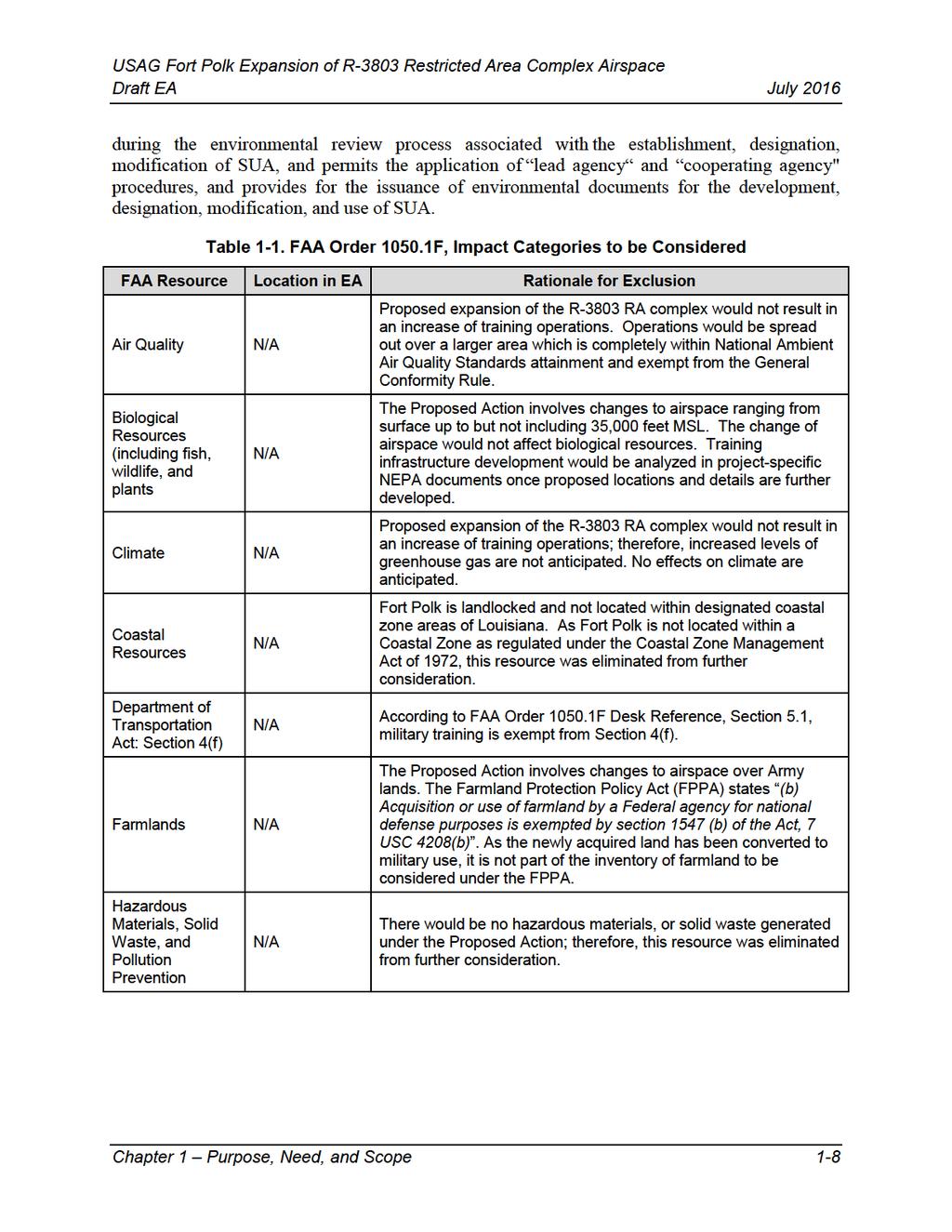
21 If any comments on the draft EA are received, following the release of the draft FNSI, they will be incorporated in the EA process. If no significant impacts are identified, the final EA will be produced and a FNSI published in accordance with each agencies regulation. If there is a finding of significant impact, then a higher level of NEPA analysis would be required and a NOI to proceed with an EIS would be issued. 1.7 Cooperating Agency Status Establishing new RA is a Federal rulemaking action that must be approved and implemented by the FAA. Rulemaking actions require environmental analysis pursuant to FAA s own NEPA implementing regulations (FAA Order F). To ensure that the environmental review process for the RA proposal meets both Army and FAA NEPA requirements, the FAA has agreed to act as a cooperating agency in the preparation of this EA. If the Army EA process results in a FNSI, the Army will forward the airspace proposal and the Final EA/FNSI to the FAA. The FAA will then publish a Notice of Proposed Rulemaking in the Federal Register and initiate a 45-day public comment period. Based on an evaluation of the Army airspace proposal, the Final EA/FNSI, and comments received in response to the Notice of Proposed Rulemaking, FAA Headquarters will approve or deny the proposed rule. If approved, the FAA will issue its own NEPA decision document and publish the Final Rule in the Federal Register. The Army formally requested the FAA serve in the capacity of an official Cooperating Agency on August 29, The FAA agreed to serve as a cooperating agency for this EA. The FAA is responsible for managing navigable airspace for public safety. Additionally, it is responsible for ensuring efficient use of airspace for commercial air traffic, general aviation, and national defense, including special use airspace utilized by the DoD. The FAA has established several policies including: Order F, Environmental Impacts: Policies and Procedures (July 16, 2015); and JO K, Procedures for Handling Airspace Matters (July 24, 2014). FAA Order F provides the FAA with policies and procedures to ensure agency compliance with NEPA (42 USC 4321, et seq.) and implementing regulations issued by the CEQ (40 CFR Parts ). The Desk Reference of FAA Order F identifies 16 impact categories that should be considered during the NEPA process. This EA addresses each resource area to determine if they should be considered as prescribed by FAA Order F. The sections where each of these resources are discussed in this EA, or the rationale for excluding a detailed discussion of a specific resource, are provided in Table 1-1. FAA JO K, Chapter 32, provides guidance to air traffic personnel to assist in applying the requirements in FAA Order F to air traffic actions. To eliminate unnecessary duplication of effort between the FAA and DoD, a Memorandum of Understanding (MOU) between the FAA and DoD was signed on October 4, 2005 to provide for the issuance of environmental documents for the development, designation, modification, and use of Special Use Airspace (SUA) ( traffic/publications [see Order JO K]). The MOU describes the guidelines for compliance with NEPA and CEQ Regulations (40 CFR Parts ). This MOU promotes early coordination between FAA and DoD Chapter 1 Purpose, Need, and Scope 1-7
22
23
24 This Page Intentionally Left Blank Chapter 1 Purpose, Need, and Scope 1-10
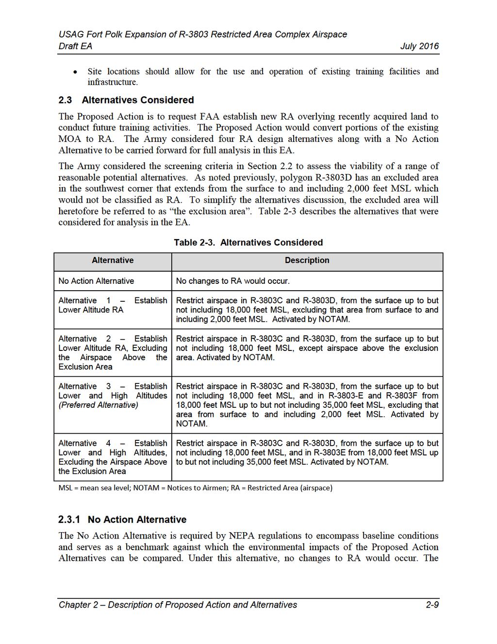
25 2 Description of the Proposed Action and Alternatives Chapter 2 describes the Proposed Action and the alternatives. To address the purpose and need, four alternatives are fully analyzed in this EA, along with the No Action Alternative. Consideration of the No Action Alternative is mandated in the CEQ 40 CFR Parts and Environmental Analysis of Army Actions 32 CFR Part This EA addresses the resulting environmental impacts of each alternative of the Proposed Action. 2.1 Proposed Action The Proposed Action is to establish new RA over acquired land. The proposed RA would enable the Army to conduct the necessary type, level, duration, and intensity of live-fire and other military training exercises for the combat units assigned to Fort Polk and the rotational training units (RTUs) at the JRTC. The JRTC and Fort Polk would conduct battalion-level CALFEX on newly acquired training lands. CALFEX is a costly, resource-intensive exercise in which combined arms teams, or task forces, maneuver and employ supporting weapon systems. It is the most realistic measure of combined arms combat readiness and should be an integral part of every unit s training program. Section provides additional details on CALFEX training and justification for an expansion of the R-3803 RA complex airspace to support such training activities. The Proposed Action is required to ensure safe live artillery fire training while protecting the public from both air and ground maneuvers using advanced weapon systems, as well as manned flight, electronic jamming, lasers, flares, smoke, powerful simulators, and high explosive activities. Because of advances in weapon systems, modern forces are required to cover more ground in dispersed areas of operation and operate over greater distances than ever before. The increase of maneuver area is necessary to satisfy the training needs of the new air-to-air and airto-ground combat teaming. The additional RA would consist of a lateral and vertical increase of the current RA within the R-3803 complex. Implementing the Proposed Action would enhance the use of current ranges and impact areas for larger weapon systems with higher trajectories including Hellfire missiles that require up to 35,000 feet Above Ground Level (AGL) and an extended lateral distance from targets. The Proposed Action meets the need to safely train Soldiers in the most realistic environment possible, while segregating the public from hazardous military operations. Implementing the Proposed Action would establish a safety buffer for live-fire ammunitions, increase the current air battle-space environment, and provide the Army with ability to realistically train current and future multi-service combat forces in preparation for deployment for global conflicts. Additional RA within the Warrior Military Operations Area (MOA) would not only facilitate home station unit training but also provide the realistic training of RTUs. Use of non-firing maneuver areas, in conjunction with live-firing ranges would assist in promoting realism as well as adding tactical training not possible on live-fire ranges alone. As mentioned earlier, Fort Polk is not ready to develop infrastructure on the new training lands. Training activities were addressed at a programmatic level in the 2010 Land Acquisition FEIS. Training infrastructure development would be analyzed in project-specific NEPA documents once proposed locations and details are further developed. Chapter 2 Description of Proposed Action and Alternatives 2-1
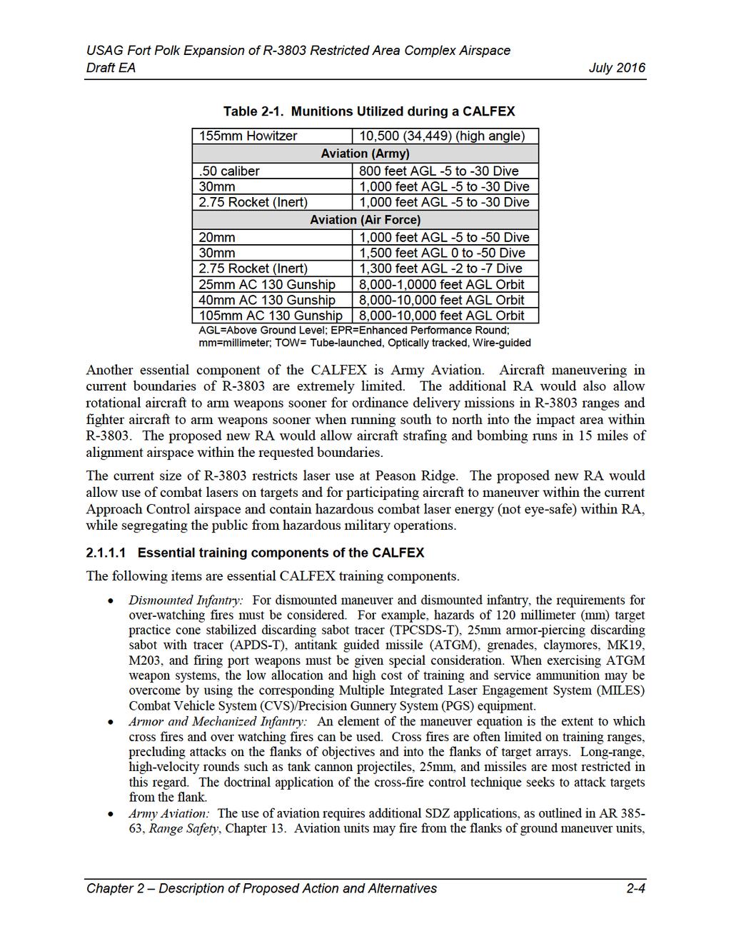
26 CALFEX Training Space Requirements The training objective of a CALFEX is to accomplish a designated combat mission (attack, defend, movement to contact) with live ammunition, a realistic target array, and required support and sustainment unit assets. Standards are found in applicable Combined Arms Training Strategies (CATS) for the selected mission, as modified by local conditions and the commander s guidance. CALFEX is designed to test the unit s and leader s ability to take knowledge learned from crew gunnery tables and apply it to tactical combat scenarios at the section, platoon, and company team levels, to include combined arms sections and platoons. Optimally, a CALFEX range maneuver area would be 5 to 10 kilometers (km) deep, 3 to 5 km wide (possibly smaller for a defensive scenario), with multiple terrain features, and would allow for some cross and flanking fires. The target array should be capable of portraying a mechanized infantry company or tank company in the offense or a mechanized infantry company with at least one platoon forward in the defense. For safety purposes, Surface Danger Zones (SDZs) are established to protect personnel and equipment. The SDZ is a depiction of the mathematically predicted area a projectile will impact upon return to earth, either by direct fire or ricochet. The SDZ is the area extending from a firing point to a distance downrange based on the projectiles fired. The SDZ required for a CALFEX could extend up to 25 km deep and 15 km wide (this can be smaller if cross fires are limited and the terrain provides a backstop). Appropriate sites should be available for the tactical operation center (TOC), battalion trains (BTs), after action review (AAR) site, and company team assembly areas (AAs). The CALFEX range should be supported by suitable areas for a forward arming and refueling point (FARP), if attack helicopters are included, as well as mortar and field artillery (FA) firing points. Implementing CALFEX on the new land would require a safety buffer for live-fire ammunitions. The additional RA would consist of a lateral and vertical increase of the current RA, R Implementing the Proposed Action would also enhance the use of current ranges for larger weapon systems with higher trajectories. Artillery firing points needed for the CALFEX on the newly acquired land would produce SDZs and a corresponding vertical hazard that expands beyond the existing boundaries of R Figure 2-1 illustrates the need for RA based on the height of the munitions utilized during a CALFEX. Table 2-1 describes the vertical hazards by ammunition type utilized during CALFEX. Chapter 2 Description of Proposed Action and Alternatives 2-2
27
28
29 or between them, but not from their rear (no overhead fire). When ATGMs or aerial rockets are to be fired, the back blast area must be considered. If helicopters are to maneuver down range from the ground element, their safety must be considered. If Joint Air Attack Team (JAAT) operations are planned, the fire support officer (FSO), forward air controller (FAC), and air battle captain (ABC) exercise the necessary command and control measures. While the aviation systems involved are entirely out of the sphere of control of the maneuver company team commander, the event may be integrated into the scenario without interfering with the flow of the exercise. This is a valid training objective for Army aviation units, close air support (CAS) pilots, and battalion fire support elements. Field Artillery Training Requirements: Artillery training is an integral aspect of the Army s readiness program, and Field Manual (FM) , Field Artillery Gunnery (FM , US Army 2006) is the cornerstone of the Army s artillery program. This FM provides prescriptive guidelines and rationale for standardized gunnery training and describes operation and training strategies to achieve the high standards set forth in Army doctrine. The CALFEX offers the FA commander an opportunity to observe and evaluate his subordinate battalion fire support elements and fire support teams (FISTs). If necessary, the firing points that support the CALFEX range must be identified, and the sequence of events may have to allow for FA registration fires. Mortars Training Requirements. Mortar training is an integral aspect of Soldier and unit readiness. The mortar s role in overall task force operations is also important. CALFEX train Soldiers and commanders on the integration of battlefield units to obtain a single cohesive force. When supporting live fire exercises (LFXs), mortar firing points must be planned to avoid firing over the heads of troops. To increase the training benefit for mortar crews, the exercise should be planned to cause mortars to displace and provide continuous support. Many of the safety considerations discussed for FA are applicable to mortars. Close Air Support: When employed, the sorties should be allocated to the battalion task force and controlled by the unit s FAC. Aircraft fly within the constraints of local range regulations, and an airspace coordination area should be established to allow surface fires while CAS is employed. Air Defense Artillery: Missile systems (such as Stinger, Redeye) may be maneuvered on the range in accordance with the unit s task organization; however, the availability of missiles is normally too low to facilitate live-fire as well as SDZ sizes. Also, air defense artillery (ADA) missile systems are more difficult to integrate into CALFEX. Therefore, it may be more effective to employ gun systems (e.g., Avenger, Bradley Fire Support Team). Engineers: Minefields, demolitions, and other obstacles should be planned in support of a defensive exercise. On some facilities, the actual emplacement of obstacles may be restricted for various reasons. If the obstacle is to be simulated, it must be emplaced (as much as the situation will allow) on an adjacent training area. Obstacles that are planned, resourced, and emplaced should be granted obstacle effect by increasing target engagement times and decreasing the array according to the type of obstacle. If demolition is authorized on the range, the required safety precautions must be strictly enforced Restricted Area Requirements The RA is required to ensure safe live artillery fire training while protecting the public from both air and ground maneuvers using advanced weapon systems as well as manned and unmanned flight, electronic jamming, lasers, flares, smoke, powerful simulators, and high explosive pyrotechnic activities against progressive and spontaneous enemy tactics. Because of advances in weapon systems, modern forces are required to cover more ground in dispersed areas of Chapter 2 Description of Proposed Action and Alternatives 2-5
30

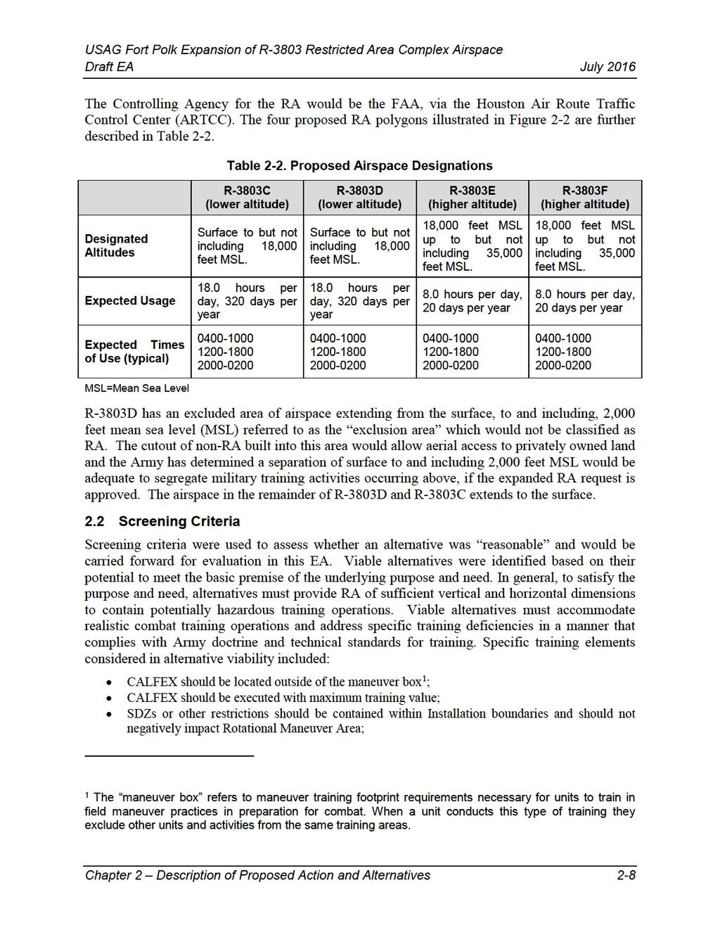
31 Figure 2-3. Vertical View of Proposed RA Chapter 2 Description of Proposed Action and Alternatives 2-7
32
33
34 current configuration of the Warrior MOAs and RAs would remain the same. Training at Fort Polk would continue to train using the Warrior MOAs and RAs. Selection of the No Action Alternative would not allow the full spectrum of CALFEX to be integrated into newly acquired lands. Proposed Action Alternative 1 Establish Lower Altitude Restricted Area Under Proposed Action Alternative 1, the Army would request that FAA reclassify a portion of the Warrior 1 MOA as RA to support future ground-to-air training requirements. The RA would include polygons R-3803C, and R-3803D with a published altitude of surface up to but not including 18,000 feet above MSL, including the airspace above the exclusion area, when activated. The RA would be activated by NOTAM and the general duration of use would occur for about 320 days per year. Figure 2-2 depicts the proposed RA boundary relative to Peason Ridge. The Controlling Agency would be the FAA Houston ARTCC, and the Using Agency would be the Commander, U.S. Army, Fort Polk, LA. The SUA reclassification and rulemaking proposal would overlie land recently acquired for training. The reclassification would provide an increased ground-to-air and air-to-ground battle-space environment similar to the existing SUA at Peason Ridge. Many of the same weapon systems currently used on Fort Polk and Peason Ridge would be used on the new training lands. Reclassifying airspace to RA is required to allow the use of many of these weapon systems as described in Section Similarity in airspace classification would also increase operating capabilities and support joint battlefield training in R Activation would occur only when needed in order to support operations that pose a hazard to commercial and general aviation such as aviation gunnery and laser training. Training activities needing RA activation would be scheduled in advance with a notification to the Houston ARTCC to activate the RA during specific times announced via NOTAM. Activities supporting activation of an RA would occur below 18,000 feet MSL. These activities include using lower angle 155mm Howitzer and 105mm cannon fire that requires 18,000 AGL; 60mm, 81mm and 120mm mortars that require 12,000 AGL; and.50 caliber machine gun ranges producing a vertical hazard that exceeds 3,500 feet AGL. Ground and air-to-ground activities would occur continuously, day and night, in support of joint battlefield training in the R-3803 complex. During a CALFEX training, the RA would be used by any of the following type of aircraft: F-16, F-15, C-130, A-10, MH/UH-60, CH-47, AC/MC-130, H-72, AH-64, OH-58, and unmanned aerial systems (UAS s) for anywhere from sorties per day. Depending on the mission, the following exercises may contain from 1 to 8 aircraft: Basic Surface Attack (BSA); Surface Attack Tactics (SATs); Suppression/Destruction of Enemy Air Defense (SEAD/DEAD); CAS; and Laser Operations. After maneuver and climb, aircraft would enter R-3803 airspace to deliver their weapons on currently existing targets. Proposed Action Alternative 2 Establish Lower Altitude Restricted Area, Excluding the Airspace Above the Exclusion Area Under Proposed Action Alternative 2, the Army would request that FAA reclassify a portion of the Warrior 1 MOA as RA. The RA would include polygons R-3803C, and R-3803D with a Chapter 2 Description of Proposed Action and Alternatives 2-10
35 published altitude of surface up to but not including 18,000 feet above MSL, except the airspace above the exclusion area, when activated. The Controlling Agency would be the FAA Houston ARTCC, and the Using Agency would be the Commander, U.S. Army, Fort Polk, LA. The SUA reclassification and rulemaking proposal would overlie land recently acquired for training. Activities that would occur under Alternative 2 are identical to those discussed in Alternative 1. Figure 2-2 depicts the proposed RA boundary relative to Peason Ridge. Proposed Action Alternative 3 Establish Lower and High Altitudes (Preferred Alternative) The Army has chosen Proposed Action 3 as their Preferred Alternative. Under Proposed Action Alternative 3, the Army would request that FAA reclassify a portion of the Warrior 1 MOA as RA. The RA would include a combination of polygons R-3803C and R-3803D with a published altitude of surface up to but not including 18,000 feet above MSL, and polygons R-3803E and R- 3803F with a published altitude from 18,000 feet MSL to but not including 35,000 feet above MSL, including the airspace above the exclusion area, when activated. The Controlling Agency would be the FAA Houston ARTCC, and the Using Agency would be the Commander, U.S. Army, Fort Polk, LA. The SUA reclassification and rulemaking proposal would overlie land recently acquired for training. Activities that would occur in lower altitude polygons R-3803C and R-3803D under Alternative 3 are identical to those discussed in Alternative 1. Access to higher altitude RA defined in polygons R-3803E and R-3803F would allow additional training activities that produce vertical hazard exceeding 18,000 feet MSL. Some of these activities include laser operations (Training/Combat), 105mm and 155mm Howitzer detonated with higher charges, and Hellfire missiles. Figure 2-2 depicts the proposed RA boundary relative to Peason Ridge. Proposed Action Alternative 4 Establish Lower and High Altitudes, Excluding the Airspace Above the Exclusion Area Under Proposed Action Alternative 4, the Army would request that FAA reclassify a portion of the Warrior 1 MOA as RA. The RA would include a combination of polygons R-3803C and R- 3803D with a published altitude of surface up to but not including 18,000 feet above MSL, and polygons R-3803E and R-3803F with a published altitude from 18,000 feet MSL to but not including 35,000 feet above MSL, except the airspace above the exclusion area, when activated. The Controlling Agency would be the FAA Houston ARTCC, and the Using Agency would be the Commander, U.S. Army, Fort Polk, LA. The SUA reclassification and rulemaking proposal would overlie land recently acquired for training. Activities that would occur in lower altitude polygons R-3803C and R-3803D under Alternative 4 are identical to those discussed in Alternative 1. Access to higher altitude RA defined in polygons R-3803E and R-3803F would allow additional training activities that produce vertical hazard exceeding 18,000 feet MSL. As in Alternative 3, some of these activities include laser operations (Training/Combat), 105mm and 155mm Howitzer detonated with higher charges, Hellfire missiles, and other training. Figure 2-2 depicts the proposed RA boundary relative to Peason Ridge. Chapter 2 Description of Proposed Action and Alternatives 2-11
36 2.4 Alternatives Considered but Dismissed Establishment of RA Elsewhere on Fort Polk Lands or Use of Existing RA Fort Polk considered establishment of additional RA elsewhere within Fort Polk s boundaries and the use of existing RA to meet training objectives. A suitable area within Fort Polk lands compatible for proposed training activities and establishment of restricted airspace does not exist. The proximity of the Main Post to Peason Ridge and the existing R-3803 and R-3804 complexes would restrict the ability of the new air-to-ground combat teaming and live-fire activities into the Peason Ridge impact areas, an integral component of CALFEX. This would also interfere with the maneuver box. Conduct Training at Other Active installations An alternative considered but dismissed was to conduct training at other military installations. This alternative would not be practical. Other installations would not be able to accommodate this type of training and training levels along with the training requirements of their own supported and home-stationed units. In addition, such an action would result in lost training time for Soldiers and inefficient use of appropriations (funds) for training due to increased costs that would result from extensive logistics and transportation. Conduct Simulated Training Another alternative considered but dismissed was to provide Soldiers with simulated training opportunities. This alternative, however, would not prepare Soldiers for deployment as technology has not advanced sufficiently to enable simulations alone to provide Soldiers and units adequate training to meet doctrinal training readiness standards. Chapter 2 Description of Proposed Action and Alternatives 2-12
37 3 Affected Environment and Environmental Consequences This chapter describes the impact assessment methodology, the affected environment (existing conditions), and the environmental consequences for the No Action and Proposed Action Alternatives. The description of baseline data sources and impact assessment methodologies are discussed in Sections and 3.1.2, respectively. Various resources were determined not to be affected by the Proposed Action Alternatives; therefore, a detailed analysis of these topics is not presented in this chapter. A discussion of VECs carried through for further analysis within this EA and justification for those VECs dismissed from further analysis are presented in Section 1.7 (regarding FAA impact categories to be considered) and in Section (regarding Army level of VEC analysis). 3.1 Impact Assessment Methodology Description of Baseline and Data Sources The following types of data were used to characterize the affected environment discussion within the EA: Geographical Information System (GIS) data. FAA Sectional Mapping. Previous NEPA documentation. Interviews with Subject Matter Experts (SMEs). Agency consultation. Approach for Analyzing Impacts Context and intensity are taken into consideration in determining a potential impact s significance, as defined in 40 CFR Part The intensity of a potential impact refers to the impact s severity and includes consideration of beneficial and adverse impacts, the level of controversy associated with a project s impacts on human health, whether the action establishes a precedent for future actions with significant effects, the level of uncertainty about project impacts, or whether the action threatens to violate Federal, state, or local law requirements imposed for protection of the environment. The severity of environmental impacts is characterized by the following definitions: None/Negligible The impact is known or maybe can occur but is unmeasurable. Minor A minor impact would either be isolated and localized or not measurable on a wider scale. Moderate Moderate impacts to a resource would be measurable on a wide scale (e.g., outside the footprint of disturbance or on a landscape level). If moderate impacts are adverse, they would not exceed limits of applicable local, state, or Federal regulations. Significant A significant impact may exceed limits of applicable local, state, or Federal regulations or would untenably alter the function or character of the resource. The threshold of significance would be a significant impact. These impacts would be considered significant unless mitigable to a less-than-significant level. Beneficial Impacts would benefit the resource/issue. Impacts that range from none to moderate are considered less than significant. Chapter 3 Affected Environmental and Environmental Consequences 3-1
38 To maintain a consistent evaluation of impacts in the EA and in accordance with the Army NEPA Regulations, significance thresholds were established for each resource (see Table 3.1-1). Although some thresholds have been designated based on legal or regulatory limits or requirements, others reflect discretionary judgment on the part of the Army in accomplishing its primary mission of military readiness, while also fulfilling their conservation stewardship responsibilities. Quantitative and qualitative analyses have been used, as appropriate, in determining whether, and the extent to which, a threshold would be exceeded. Based on the results of these analyses, this EA identifies whether a particular potential impact would be adverse or beneficial, and to what extent. A region of influence (ROI) was determined for each resource area, based on the potential impacts to the affected resource. For example, the ROI may focus on the specific location of an alternative, the installation and surrounding area, or may include the entire watershed. Table presents resource-specific ROIs and the relevant factors in evaluating the context and intensity of a potential impact to determine if the impacts may be significant. The ROI was generally limited to the installation for the following VECs: biological resources, wetlands, soils, land use, and hazardous and solid wastes, as these VECs are directly connected to specific existing conditions and activities within the installation. For the remaining VECs, the ROI was generally expanded to include larger geographic areas (e.g., airsheds for air quality, watersheds for surface waters, and noise zones for characterization and assessment of the noise environment). Level of VEC Analysis In compliance with the NEPA and CEQ regulations, the description of the affected environment focuses on those VECs and conditions potentially subject to effects from implementing the Proposed Action. CEQ regulations encourage NEPA analyses to be as concise and focused as possible. This is in accordance with CEQ regulations at 40 CFR Part (b) and (b): NEPA documents must concentrate on the issues that are truly significant to the action in question, rather than amassing needless detail.prepare analytic rather than encyclopedic analyses. Table presents each VEC and corresponding ROIs and thresholds of significance. The table also identifies those VECs that are dismissed from further analysis or are fully analyzed in this EA, and the rationale for dismissing or analyzing each VEC. In conducting this analysis, a qualified SME reviewed the potential direct and indirect effects of the No Action Alternative and the Proposed Action Alternatives relative to each VEC. The SME carefully analyzed and considered the existing conditions of each VEC within the Proposed Action's ROI. Through this analysis, it was determined that, for several VECs, negligible adverse effects would occur. Chapter 3 Affected Environmental and Environmental Consequences 3-2
39 Table VEC Assessment Criteria and Level of Assessment VEC Airspace Land Use Geology and Soils Spatial Boundary Airspace components above and within the vicinity of the Fort Polk installation boundary relevant to training and operational purposes. Installation boundary or ROI. Geology within sub-watersheds of the installation boundary. Soils within the ROI. Thresholds of Concern Proposed Action Would Cause or Result in 1, 2 A significant impact to airspace would occur if the Proposed Action violates FAA regulations, undermines the safety of either civil or commercial aviation, or infringes upon current private and commercial airspace, flight activity and flight corridors. Concern that land use conflicts will occur. Examples include: Preclusion of implementation of or conflicts with Fort Polk Integrated Natural Resources Management Plan, or JRTC and Fort Polk Real Property Master Plan. Reduction in access to or availability of publicly or privately owned mineral resources. Soil loss or compaction to the extent that natural reestablishment of native vegetation within two growing seasons is precluded unless substantial rehabilitation efforts are undertaken. Dismissed from Further Analysis? No Yes Yes Rationale for Level of Assessment The Proposed Action would include rulemaking with the FAA to restrict existing commercial airspace over recently acquired lands. If established, the RA has the potential to affect private and commercial flight activity. Therefore, this VEC is carried forward for further analysis (see Section 3.2). The proposed expansion of the R-3803 RA complex would occur over existing military lands, and would therefore, be compatible to military land uses directly beneath. If selected, the Army would restrict airspace within the exclusion area to minimize conflicts with private land uses. The Army would analyze the potential for land use conflicts to off-post lands from Training infrastructure development and related future training activities in follow-on, site specific NEPA. Section 3.2 discusses potential effects private airspace use within the exclusion area and Section 3.3 discusses potential effects of noise to surrounding land uses. The Proposed Action Alternatives involve reclassification of airspace to RA; no disturbance geology or soils would occur. The Army would analyze the potential for impacts to geology and soils from future range construction projects and training activities in follow-on, site-specific NEPA. As a result, this VEC is dismissed from further analysis. Chapter 3 Affected Environmental and Environmental Consequences 3-3
40 Table VEC Assessment Criteria and Level of Assessment VEC Spatial Boundary Thresholds of Concern Proposed Action Would Cause or Result in 1, 2 Dismissed from Further Analysis? Rationale for Level of Assessment Water Resources: Groundwater, Surface Water Quality, Streams, Wetlands, and Other Surface Water Resources Aquifer within the ROI (groundwater). Sub-watershed, USACE jurisdictional Waters of the U.S., or statedesignated stream segment within the installation boundary. Degradation of aquifer quality; Violation of drinking water standards. Sedimentation into streams. Discharge into streams. Wetlands or other waters of the U.S. within footprint or adjacent (within a distance to be concerned about sedimentation) within the watershed. State scenic stream within footprint or adjacent (within a distance to be concerned about sedimentation) within the watershed. Net loss of wetlands (bogs, baygalls, hillside seeps, or riparian zones) within installation boundary (unmitigated) due to direct or indirect effects (e.g., sedimentation). Permanent conversion or net loss of forest lands at landscape scale of > 5 percent relative to baseline. Permanent net loss of Redcockaded woodpecker (RCW) foraging habitat from land base to level below that required for achieving long-term RCW population recovery objectives. Permanent loss or degradation of designated rare/sensitive plant sites; Introduction or increased prevalence of undesirable nonnative species. Yes The Proposed Action Alternatives involve changes to airspace ranging from surface up to but not including 35,000 feet MSL. This change would not directly or indirectly cause adverse impacts to water resources. The Army would analyze the potential water resource impacts from future range construction projects and training activities in follow-on, site-specific NEPA. As a result, this VEC is dismissed from further analysis. Biological Resources: Forest Conditions, Native Plant Species and Communities, Nonnative and Invasive plant species Installation boundary. Yes The Proposed Action Alternatives involve changes to airspace ranging from surface up to but not including 35,000 feet MSL. The change of airspace would not affect native plant species and communities, nor would the airspace change cause introduction or spread of nonnative and invasive plant species. The Army would analyze the impacts to plant communities from future range construction projects and training activities in follow-on, site specific NEPA. As a result, this VEC is dismissed from further analysis. Chapter 3 Affected Environmental and Environmental Consequences 3-4
41 Table VEC Assessment Criteria and Level of Assessment VEC Biological Resources: Wildlife and Aquatic Life Biological Resources: Rare, Threatened, and Endangered Species Cultural Resources Spatial Boundary Installation boundary. Species home range, local habitat, or migratory range intersecting the Installation boundary. Home range or protected habitat within the Installation boundary. Site-specific. Thresholds of Concern Proposed Action Would Cause or Result in 1, 2 Long-term loss or impairment of a substantial portion of local habitat (species-dependent.; Biologically significant decline in Migratory Bird Treaty Act population. Reduction of RCW foraging habitat for one or more clusters/groups. Reduction in Habitat Management Unit acreage. Alleviation of time for biologist to manage the species. Direct mortality or other unpermitted take of threatened or endangered species. Irretrievable or irreversible damage to a prehistoric or historic site that is listed or is eligible/potentially eligible for listing on the National Register of Historic Places. Dismissed from Further Analysis? Yes Yes Yes Rationale for Level of Assessment The Proposed Action Alternatives involve changes to airspace ranging from surface up to but not including 35,000 feet MSL. The change of airspace would not affect wildlife and aquatic life. The Army would analyze the potential species impacts from future range construction projects and training activities in follow-on, site specific NEPA. As a result, this VEC is dismissed from further analysis. The Proposed Action Alternatives involve changes to airspace ranging from surface up to but not including 35,000 feet MSL. The change of airspace would not affect protected species. The Army would analyze the potential protected species impacts from future range construction projects and training activities in follow-on, site specific NEPA. As a result, this VEC is dismissed from further analysis. The Proposed Action Alternatives involve changes to airspace ranging from surface up to but not including 35,000 feet MSL. The change of airspace would not adversely affect cultural resources. Fort Polk continues to inventory cultural resources within the newly acquired lands and coordination with the State Historic Preservation Officer is continuing. These resources are afforded protection per the Integrated Cultural Resource Management Plan. The Army would analyze the potential adverse effects to cultural resources from future range construction projects and training activities in follow-on, site specific NEPA. As a result, this VEC is dismissed from further analysis. Chapter 3 Affected Environmental and Environmental Consequences 3-5
42 Table VEC Assessment Criteria and Level of Assessment VEC Spatial Boundary Thresholds of Concern Proposed Action Would Cause or Result in 1, 2 Dismissed from Further Analysis? Rationale for Level of Assessment Noise Land use zones within the ROI and Installation boundary. Exceedance of noise limit guidelines published in AR200-1, Chapter 7 (1997). Exceedance of existing 65 dba contour by 17 percent AIA. No The Proposed Action Alternatives involve changes to airspace ranging from surface up to but not including 35,000 feet MSL. This would allow military aircraft operations within new airspace, potentially including operations above private landholdings within the exclusion area. Therefore, the potential exists for increase in noise levels to populations outside of the installation. As a result, this VEC is carried forward for further analysis (see Section 3.3). The Proposed Action Alternatives involve changes to airspace ranging from surface up to but not including 35,000 feet MSL. No net increase in aircraft or vehicle, emissions would occur; training would be spread out over a larger area including the newly acquired lands and airspace above those lands. Fort Polk, including Peason Ridge and the newly acquired lands are within the Shreveport- Texarkana-Tyler Interstate Air Quality Control Region (40 CFR Part 81.94). This area attains the NAAQS standards for all criteria pollutants. The General Conformity Rule only applies to criteria pollutants in the ROI which are in nonattainment or maintenance for the NAAQS. Therefore, de minimis levels for the project area are not applicable. Implementation of the Proposed Action Alternatives would have negligible impacts on air quality. Therefore, no further analysis is required. Air Quality Airshed (AQCR 106)(AQCR 22) or Installation boundary (Title V) Violation of National Ambient Air Quality Standards (NAAQS). Yes Chapter 3 Affected Environmental and Environmental Consequences 3-6
43 Table VEC Assessment Criteria and Level of Assessment VEC Social Conditions: Public Access and Recreational Use, Public Services, Public Safety and Protection of Children, Environmental Justice Economics Spatial Boundary Installation boundary or ROI. ROI. Thresholds of Concern Proposed Action Would Cause or Result in 1, 2 Long-term substantial loss or displacement of recreational opportunities/resources relative to baseline. Substantial degradation of recreational value. Exceedance of Rational Threshold Value (RTV) for population and assessment of baseline social services. Need for increase in large-scale facilities (e.g., new school or hospital); Public safety hazard from military operations. Public health hazard from exposure to hazardous waste or hazardous materials. Disproportionate environmental health or safety risk to children. Disproportionate environmental economic, social, or health impacts on minority or low income populations (EO 12898). Accidence of RTV for socioeconomic indicators (i.e., modeled population, personal income, employment, or business activity exceeds the difference between the maximum and average historical level over the past 19 years). Dismissed from Further Analysis? Yes Yes Rationale for Level of Assessment The Proposed Action Alternatives involve changes to airspace over ranging from surface up to but not including 35,000 feet MSL. The Proposed Action would not impact public access, recreation, public service or public safety. No low-income or minority populations greater than 50 percent that of Vernon Parish or with populations meaningfully greater than that of Vernon Parish (i.e., greater than 120 percent) have been identified near the newly acquired lands. The Proposed Action would also not disproportionately affect the environmental health or safety of children populations. Overall impacts to Socioeconomics and Environmental Justice would be negligible and further analysis has been dismissed from further analysis. The Proposed Action Alternatives involve changes to airspace over ranging from surface up to but not including 35,000 feet MSL. The Proposed Action would not impact sales volume, income, employment, or the local tax base. Overall economic impacts would be negligible and further analysis has been dismissed from further analysis. Chapter 3 Affected Environmental and Environmental Consequences 3-7
44 Table VEC Assessment Criteria and Level of Assessment VEC Transportation and Infrastructure Spatial Boundary ROI or Installation boundary. Thresholds of Concern Proposed Action Would Cause or Result in 1, 2 Decrease in Level-of-Service (LOS) of key installation arteries and collectors below the acceptable LOSD. Road failure resulting in rutting, cracking, or other pavement problems that require substantial maintenance or rehabilitation activities. Violation of an FAA regulation that undermines the safety of commercial passengers or personnel at Alexandria International Airport/England Industrial Airpark. Impairment of installation s ability to meet federally mandated or Army objectives for waste minimization and pollution prevention. Accidence of existing facility or system capacity for hazardous waste/hazardous material management, storage, disposal, or emergency response; water supply and sewage treatment; or utility services. Dismissed from Further Analysis? Yes Rationale for Level of Assessment The Proposed Action Alternatives involve changes to airspace ranging from surface up to but not including 35,000 feet MSL. No changes would occur to traffic or transportation. The Proposed Action Alternatives would not require the construction of new roadways or trails. Furthermore, implementation of the Proposed Action Alternatives would not increase the level of traffic within or surrounding Fort Polk. Training could cause road closures within the newly acquired lands; however, these closures would not affect public roadways or traffic flow. Utility and facility requirements for the Proposed Action Alternatives are not anticipated as no new construction would occur. The Army would analyze the construction of new range facilities and associated utility usage in follow-on NEPA. Therefore, these VECs have been dismissed from further consideration. Chapter 3 Affected Environmental and Environmental Consequences 3-8
45 Table VEC Assessment Criteria and Level of Assessment VEC Spatial Boundary Thresholds of Concern Proposed Action Would Cause or Result in 1, 2 Dismissed from Further Analysis? Rationale for Level of Assessment General Compliance Installation boundary or limits of affected environmental media. Violations of federal or state environmental rules, regulations, or permits held by the installation. Yes The Proposed Action Alternatives involve changes to airspace ranging from surface up to but not including 35,000 feet MSL. No violations of federal or state environmental rules, regulations or permits held by fort Polk would occur. The Proposed Action would include rulemaking with the FAA to restrict existing commercial airspace over recently acquired lands. [1]. Although some thresholds have been so designated based on legal or regulatory limits or requirements, others reflect discretionary judgment and BMPs on the part of the Army in accomplishing their primary missions of military readiness and management of these lands (including multiple use and access), respectively, while also fulfilling their conservation stewardship respons bilities. Quantitative/qualitative analysis may be used, if appropriate, in determining whether, and the extent to which, a threshold is exceeded. [2]. Thresholds listed are for potential effects of the alternative prior to or without mitigation. AIA=Associates in Acoustics; Db=decibel; DoD=Department of Defense; FAA=Federal Aviation Administration; LOS=level of service; NAAQS= National Ambient Air Quality Standards; NEPA=National Environmental Policy Act; RA=restricted area (airspace); RCW= Red-cockaded woodpecker; ROI=Region of Influence; RTV= Rational Threshold Value; USACE=U.S. Army Corps of Engineers; VEC=Valued Environmental Component Chapter 3 Affected Environmental and Environmental Consequences 3-9
46 Cumulative Effects CEQ regulations implementing NEPA defines a cumulative impact as follows: Cumulative impact is the impact on the environment, which results from the incremental impact of the action when added to other past, present, and reasonably foreseeable actions regardless of what agency (Federal or non-federal) or person undertakes such other actions. Cumulative impacts can result from individually minor but collectively significant actions taking place over a period of time (40 CFR ). U.S. Environmental Protection Agency (USEPA) guidance to reviewers of cumulative impacts analyses further adds: the concept of cumulative impacts takes into account all disturbances since cumulative impacts result in the compounding of the effects of all actions over time. Thus, the cumulative impacts of an action can be viewed as the total effects on a resource, ecosystem, or human community of that action and all other activities affecting that resource no matter what entity (Federal, non- Federal, or private) is taking the action (USEPA, 1999). For the purposes of this EA, cumulative impacts result from the incremental impacts of the action when added to other past, present, and reasonably foreseeable actions regardless of who undertakes such actions. Cumulative impacts can result from individually minor, but collectively significant, actions taking place over a period of time. For the purposes of the cumulative impacts analysis, the Proposed Action's ROI is limited to Fort Polk and adjacent lands (including communities around the installation). This ROI includes areas where the Proposed Action's effects would most likely contribute to cumulative environmental effects. The Army considered a wide range of past, present, and reasonably foreseeable future actions in the ROI that could contribute to cumulative environmental effects. The Army considered past, present, or foreseeable future actions regardless of whether the actions are similar in nature to the Proposed Action or outside the jurisdiction of the Army. Cumulative effects are addressed within each resource section following the discussion of environmental consequences for each alternative. This analytical approach provides a more complete understanding of resource conditions that implementation of the Proposed Action might magnify, amplify, or otherwise exacerbate or cause beneficial or adverse effects (i.e., synergistic or countervailing effects) to resources on a regional or temporal scale. Section discusses projects and activities considered as part of the cumulative impact analysis. Projects considered for this analysis include those activities occurring within Peason Ridge, the newly acquired training lands, and activities off-post adjacent to the installation boundary. No major projects or activities within the Fort Polk Main Post were identified which could cumulative and adversely contribute to significant adverse environmental effects from implementation of the Proposed Action Alternatives Fort Polk Projects (Past, Present, and Reasonably Foreseeable) Overall funding for military construction and range development projects has been cut in today s fiscal environment. While the Army will evaluate specific training infrastructure and locations within the new range area in future NEPA analyses, it is known that training activities would be conducted on the new ranges in a similar fashion to existing training activities at Peason Ridge. This may include artillery and mortar fire from new firing points established in the new range Chapter 3 Affected Environmental and Environmental Consequences 3-10
47 area to existing impact areas on Peason Ridge. It will likely include additional CAS, BSA, SEAD/DEAD, SAT, medical evacuation (MEDEVAC), laser operations, electronic warfare (E- War), explosive ordinance disposal (EOD), flare drop, smoke, landing zone (LZ) and drop zone (DZ) use, FARP and UAS operations. Development of infrastructure to support these activities would have the potential to adversely impact VEC areas identified in Table 3.1-1, however, impacts would be regulated and reduced by compliance with existing federal regulations (e.g., Clean Water Act, Clean Air Act, National Historic Preservation Act, Endangered Species Act), permitting requirements (e.g., Section 401, air permits), and managed by existing Fort Polk management plans (e.g., hazardous waste, noise, natural and cultural resources). Projects on the newly acquired lands have consisted primarily of general training area preparation and maintenance, including land clearing, trail improvements, establishment of borrow pits, timber harvesting, prescribed burns, establishment of fire breaks, and minor infrastructure improvements (e.g., shed construction). Training on the newly acquired lands consists of foot maneuvers and vehicle use of existing roads and trails. No live fire is currently conducted; however as previously stated, potential future range construction projects and subsequent live-fire training are likely to occur on the newly acquired lands and would be evaluated in follow-on, site-specific NEPA analyses. Ongoing training at Peason Ridge includes intensive maneuver and live-fire training. The Main Post and Peason Ridge are connected by the yellow brick road, which provides a corridor for convoy operations between the two training areas. No other major projects or activities have been identified that would cumulatively alter the noise or airspace environments on the newly acquired lands or Peason Ridge Other Agency (DoD and non-dod) and Other Public/Private Actions (Past, Present, and Reasonably Foreseeable) Commercial and private aviators transit the airspace near the Proposed Action and utilize local airports as described in Section 3.2. Land use surrounding the newly acquired training areas is predominately rural with small inclusions of sparsely populated residential development, and ongoing activity includes timber management and agriculture. Land use within the exclusion area includes private rural residential development. Chapter 3 Affected Environmental and Environmental Consequences 3-11
48 This Page Intentionally Left Blank Chapter 3 Affected Environmental and Environmental Consequences 3-12
49
50

51 Figure Sectional Showing Existing and Proposed RAs. Chapter 3 Affected Environmental and Environmental Consequences 3-15
 or a designated altitude (typically 1,200 feet AGL) to the overlying or adjacent controlled airspace.")
52 Class-E airspace is any controlled airspace which is not Class A, B, C, or D. It extends upward from either the surface (around airports) or a designated altitude (typically 1,200 feet AGL) to the overlying or adjacent controlled airspace. Class-E transitional airspace is also used by transiting aircraft to and from the terminal or an enroute environment normally beginning at 700 feet AGL up to 18,000 feet above MSL. Class-E airspace ensures that IFR traffic remains in controlled airspace when approaching aircraft within otherwise classified airspace or when flying on Victor airways (see Section , Federal Air Corridors, regarding definition of Victor airways). Federal airways have a width of four statute miles on either side of the airway centerline and occur between 700 feet AGL and 18,000 feet above MSL. Class-G airspace is otherwise uncontrolled airspace that has not been designated as Class A, B, C, D, or E. IFR aircraft do not operate in Class-G airspace with the possible exception of aligning an approach or departure on an IFR Flight Plan. This is done at their own risk, as ATC has no knowledge of VFR activity in these areas. Source: AOPA Air Safety Foundation, /media/files/aopa/home/pilot%20resources/asi/various%20safety%20pdfs/airspace2011.pdf. Figure Airspace Classification Diagram There are also SUAs designed to ensure the separation of non-participating aircraft from potentially hazardous operations or conflict with military operations. These typically include RAs and MOAs. RAs are four-dimensional sections of airspace that are to be restricted from commercial or private traffic while activated, thereby allowing unfettered execution of military operations. Different sections and stratifications can be activated or deactivated depending on training requirements. Pilots are informed of their activation by NOTAM. MOAs are fourdimensional sections of airspace defined as having a high level of military use, in order to advise commercial and private traffic to either stay clear of this area or be vigilantly aware of that type of traffic when activated. Figures and show a vertical diagram of airspace classification within the ROI. Chapter 3 Affected Environmental and Environmental Consequences 3-16
53 Figure depicts a north-south cut looking east as defined on the Sectional Figure Figure ROI Airspace Vertical Diagram-A Chapter 3 Affected Environmental and Environmental Consequences 3-17

54 Figure depicts an east-west cut looking north s defined on the Sectional Figure Figure ROI Airspace Vertical Diagram-B Chapter 3 Affected Environmental and Environmental Consequences 3-18
, and an additional 20 miles out (50-mile radius,")
55 Airspace Components The ROI straddles portions of Louisiana and Texas. Two ROIs are considered within this EA; a 30-mile radius from the bottom right corner of the existing R-3803 (referred to as the immediate ROI), and an additional 20 miles out (50-mile radius, referred to as the extended ROI). The study radius center represents the center of mass of the existing RA and the proposed RAs providing a good representation of characterizing airspace activities that could be affected by the Proposed Action (refer to Figure 3.2-5). Figure Sectional Showing ROI and Airspace Components. Chapter 3 Affected Environmental and Environmental Consequences 3-19
56 The components of the immediate ROI include R-3803A & B, the Peason Ridge Flight Landing Strip (FLS), the Avelino DZ, Warrior 1 Low & High MOAs, the Claiborne MOA, Warrior Air Traffic Control Assigned Airspace (ATCAA), and the CADDO ATCAA. Further out within the extended ROI but still of influence to airspace use at Peason Ridge are RAs R-3804A & B, R- 3801A & B, Fort Polk Army Airfield (AAF), Self FLS, Warrior 2 & 3 Low & High MOAs, as well as both overlying ATCAAs. The ROI also contains six designated airways supporting larger airports in the region as well as through traffic (see Section , Federal Air Corridors). These include the Victor Airway 212 (V-212) and the V-114 below 18,000 feet above MSL and the Jet Route 50 (J50), J58, J180, and the Q Route 38 (Q38) above 18,000 feet above MSL (refer to Section for a discussion of Victor Airways and Jet and Q Routes). The V-212 and J50 parallel the southern boundary of the proposed R-3803 C/D & E/F. There are also several medium to small, commercial, private and civilian airports (see Section , Civilian Airfields) in this area that may have an effect on airspace and air traffic within the ROI, including the following for the immediate ROI (distance measurements are from the ROI radius center point): Leesville Airport (L39) public approximately 14 miles south-southwest. Prairie Creek Airport (57LS) private approximately 9 miles south-southwest. Cook Airport (not on Sectional) private approximately 17 miles west-northwest. Hart Airport (3R4) public approximately 23 miles northwest. Natchitoches Regional Airport (IER) public approximately 29 miles north-northeast. Robinson Landing Strip (not on Sectional) private approximately 29 miles north-northeast. Bayou Camitte Landing Strip (not on Sectional) private approximately 22 miles northeast. Little River Landing Strip (not on Sectional) private approximately 25 miles northeast. Little Eva Plantation Landing Strip (not on Sectional) private approximately 24 miles northeast. Nichols Landing Strip (not on Sectional) private approximately 23 miles east-southeast. Roland Airport (70LA) (not on Sectional) private approximately 27 miles east-southeast. And for the extended ROI: Ammons Airport (5LS9) private approximately 34 miles west-northwest. Colfax Airport (not on Sectional) private approximately 32 miles east-northeast. Alexandria International Airport (AEX) public approximately 38 miles east. Chandler Airport (9LA6) private approximately 34 miles east. Myers Number 2 Landing Strip (not on Sectional) private approximately 37 miles east. Polluck Municipal Airport (L66) public approximately 44 miles east-northeast. Esler Regional Airport (ESF) public approximately 53 miles east. Pineville Municipal Airport (2L0) public approximately 44 miles east. Grass Roots Airport (05LS) private approximately 42 miles east. Woodworth Airport (1R4) public approximately 43 miles east-southeast. Summerville Airstrip (LA35) private approximately 47 miles east-southeast. Miller Landing Strip (not on Sectional) private approximately 41 miles southeast. Jasmine Hill (not on Sectional) private approximately 44 miles southeast. Andrus Landing Field (not on Sectional) private approximately 45 miles southeast. James Landing Strip (not on Sectional) private approximately 45 miles southeast. Murray Airport (not on Sectional) private approximately 46 miles southeast. Oakdale Municipal Airport (not on Sectional) public approximately 45 miles southeast. Chapter 3 Affected Environmental and Environmental Consequences 3-20
57 Allen Parish Airport (ACP) public approximately 49 miles southeast. Dyer Airport (6LA4) private approximately 50 miles southeast. BT and KH Ranch Airport (not on Sectional) private approximately 47 miles south-southeast. Swamp Smith Airport (34LA) private approximately 38 miles south. Beauregard Regional Airport (DRI) public approximately 35 miles south. Beauregard Parish Airport (not on Sectional) public approximately 33 miles south. Newton Municipal Airport (61R) public approximately 45 miles southwest. Scrappin Valley Airport (4XS5) private approximately 39 miles west-southwest. Pineland Municipal Airport (T24) public approximately 48 miles west-southwest. All airports have established imaginary surfaces, which are three-dimensional planes established in airspace surrounding airports for the protection of flight paths associated with launch/recovery (L/R). They exist primarily to prevent existing or proposed manmade objects and objects of natural growth or terrain from extending upward into navigable airspace. According to the provisions set forth in applicable criteria, an object is an Obstruction to Air Navigation if it is of greater height than any imaginary surface established under the regulation. The size and configuration of each imaginary surface is based on the classification of each runway. There are six imaginary surfaces surrounding runways on all sides which the FAA and DoD have specified for the purposes of determining obstructions to air navigation: Primary Surface, Transitional Slope, Approach-Departure Control Surface (ADCS) Slope, Inner Horizontal, Outer Horizontal, and the Conical Surface connecting the two Polk Approach Polk Approach is the primary airspace controlling agency within the ROI. They manage all air activity within a very large swath of airspace surrounding the installation (see Figure 3.2-6). This area extends from the western edge of the Warrior MOA to the Mississippi River and from near the bottom of the Warrior MOA up to the middle of the Jena and Hackett MOAs. Area of control extends from surface up to 10,000 feet above MSL. Above that the area reverts to either Houston Center (ZHU) or Fort Worth Center (ZFW) according to their standard demarcation. RA, MOAs and ATCAAs that extend above 10,000 feet above MSL are also controlled by Polk Approach when activated. Chapter 3 Affected Environmental and Environmental Consequences 3-21
 normally managed by an ARTCC.")
58 Figure Sectional Showing Polk Approach Area of Responsibility. It is an unusual condition that would allow a military function to permanently manage all flight activity (commercial, private, and military) normally managed by an ARTCC. It does however, provide unilateral control over a very complex swath of airspace which aids in separating nonparticipating aircraft from military activities Military Airfields There are four military airfields in the ROI associated with activities conducted at Fort Polk. Polk AAF is the primary permanent airfield for the majority of air traffic and the only airfield with permanently stationed aircraft. Polk AAF air traffic is managed by Polk Air Traffic Control Tower otherwise known as Tower Control. The other three airfields are for training purposes only. They are controlled by G-3 and Talatha Radio provides flight following. Talatha Radio is a position within Polk Approach Control located on Polk AAF. Military airfields have imaginary surfaces that effect airspace use akin to those described for private and public airports but which follow DoD criteria for size and configuration. An example description of an imaginary surface is for the Peason Ridge FLS, located directly adjacent to the proposed RA. The FLS requires a 150-foot wide rectangular primary surface area Chapter 3 Affected Environmental and Environmental Consequences 3-22
59 centered over the runway and extending 500 feet beyond the end of the runway. Surrounding the primary surface is the maintained area, which extends the length of the primary surface extending an additional 60 feet outwards on either side. The maintained area aligns with the beginning of the clear zone. The clear zone is a trapezoidal area with a beginning width of 270 feet (same as end of maintained area), an end width of 500 feet and a length of 500 feet. This area must be free of obstructions and must be graded to within a +10 to -20 percent slope. Encompassing the primary surface, the maintained area, and the clear zone is the exclusion area. The exclusion area is 1,000 feet wide, centered on the runway, and extends 500 feet beyond the runway end, aligning with the end of the primary surface (300-foot overrun plus 200 feet). The first 700 feet of the exclusion area should be free of all buildings, trees, or obstacles not directly associated with the airfield. The remaining 300 feet (150 feet on each side) may only contain the features required to operate the airfield such as aprons, taxiways, navigational aids (NAVAIDS), aircraft, support equipment, etc. There is no transitional slope associated with a LZ. ADCSs at the runway ends are required. The ADCS is an imaginary plane that extends upward from the end of the clear zone and is also a trapezoidal configuration. It is 500 feet wide at the beginning and 2,500 feet at the minimal outer edge distance of 10,500 feet. It is preferred but not required that this surface extend out at the same width (2,500 feet) for another 21,500 feet (32,000 feet total). This surface rises at a rate of 35 horizontal to 1 vertical. No object, fixed or mobile, may penetrate this surface, including trees, buildings, towers, or vehicles. Refer to Figure for an illustrative example of airfield clear zones and imaginary surfaces associated with Peason Ridge FLS. Polk AAF (POE). This airfield is restricted to military use only and the airspace is controlled by Talatha Radio. This airfield has a single asphalt runway of orientation/designation that is 100 feet wide by 4,109 feet in length. Runway 16 has a displaced threshold of 194 feet. It sits an average elevation of 329 feet above MSL. They are controlled by G-3 and Talatha Radio provides flight following. Talatha Radio is a position within Polk Approach Control located on Polk AAF. Otherwise the tower is manned Monday through Friday from 0700 to 2200 except for federally recognized holidays. The Class-D airspace is the center of Polk Army Airfield located on the western edge of R-3804B. It extends from surface up to 2,500 feet AGL within a 5.2 NM radius. This is surrounded by Class-E airspace encompassing Polk Approach Controls entire airspace. Civilian airports like Leesville, Many Hart, Oakdale Allen-Parish, Natchitoches, Pineville-Bulow Lake, Esler Field and Jena have a transitional Class-G uncontrolled airspace prior to entering Class-E airspace controlled by Polk Approach Control. Polk AAF lies within the R-3804B allowing for better protected launch and recovery of UAS within RA. The recovery pattern however, often goes outside of the RA boundary into Class-D airspace which does require a certificate of authorization (COA). POE is a L/R site for RQ-7B Shadow and MQ-1C Gray Eagle UAS. There are several other permanently assigned aircraft (28 total) at the airfield supporting JRTC and home station units including 11 UH-60 Blackhawks (six are MEDEVAC), seven LUH-72 Lakota, and ten OH-58 Kiowa. There is also considerable transient traffic for units attending and participating in JRTC. POE manages approximately 458 operations per day based on FY15 operations. Chapter 3 Affected Environmental and Environmental Consequences 3-23
60 Self Flight Landing Strip. The Self FLS is an improved gravel strip located a few miles from POE, immediately east of the North Fort Polk cantonment. The runway is approximately 3,700 feet long by 116 feet wide with a single hammerhead turnaround. It is used primarily for JRTC training exercises including tactical assault L/R for C-130 and C-17. The primary use however, is rotary wing. There are no permanently assigned aircraft, there is no functioning ATC tower, although there is a mock tower used for observation and training exercises. The airspace surrounding the airfield is just inside the edge of the POE Class-D airspace and under control of Polk Control Tower when operational and uncontrolled when Polk Control Tower is closed. The area outside of the Class-D circle and within the R-3804B is controlled by Talatha Radio. However, being out of visual range from POE, VFR traffic regularly operates in the area without Talatha Radio or Polk Approach direct control. This airfield is located within RA and is controlled by Talatha Radio. Geronimo FLS. This is an improved gravel assault strip located in the upper northeast corner of the R-3804A range. It is used for fixed wing and rotary training, drop zone for cargo and personnel including high-altitude low open (HALO) jumps from 10,000 feet above MSL and higher, and UAS L/R including RQ-7B Shadow and RQ-11 Raven. The runway is approximately 4,650 feet long by 117 feet wide with a single hammerhead turnaround. It is supported by a single gravel aircraft parking apron approximately 290 feet by 590 feet. The airfield is adjacent to a compound of training facilities. There is no control tower. Activity is managed by the Joint Aviation Control Center (JACC) Cell under the auspices of Polk Approach. Peason Ridge FLS. This is an improved gravel strip located directly adjacent to the proposed RA in the upper northwest corner of Peason Ridge within the R-3803A and adjacent to the impact area (refer to Figure 3.2-7). The runway is approximately 4,100 feet long by 100 feet wide with a single hammerhead turnaround. The runway sits at orientation There is a 320-foot by 400-foot gravel aircraft parking apron associated with the airfield located on the north side of the northwest end of the runway. There is an unmanned control tower, which is primarily just an open structure for observation with no permanent electronics. Airfield criteria require 300-foot long overruns, clear zones and imaginary surfaces for protection of aircraft and personnel as defined at the beginning of this section. With an implied 300-foot overrun on each end of this runway leaves 3,500 feet of effective runway length. There are several impediments of the clear zone and imaginary surfaces including fences, tree stands, shrubs, stumps, steep terrain, rock outcroppings, etc. The maintained area also has many shrubs and trees along its length although evidence of clearing is obvious. The southeast one third of the runway and the approach / departure slope is within Peason Ridge TA-6 and as such is within a temporary impact area. This area can be used for live-fire requiring personnel to surface clear the area after use. The airfield cannot be used during live-fire exercises and is not used until it is verified that all munition remnants are cleared. The airfield surface is checked periodically to verify it remains undamaged. Chapter 3 Affected Environmental and Environmental Consequences 3-24
61 Drop Zones There is one functioning DZ at Peason Ridge referred to as the Avelino DZ (Figure 3.2-8). The Tiger DZ is no longer active although it remains on range maps. All usage of the DZ must be scheduled with Range Operations 24 hours in advance. NOTAMS are published indicating date, time, altitudes, type of training, and number of drops planned. The DZ is used for aerial drops of cargo and personnel by a variety of methods and from a variety of aircraft, both fixed and rotary wing. The DZ is characterized as follows: Avelino DZ. This is a large rectangular DZ that is approximately 3,300 feet wide by 8,100 feet long (see Figure 3.2-8). This DZ overlies the Peason Ridge FLS with an orientation that is 153 degrees magnetic. That is approximately 13 degrees rotational difference from the Peason Ridge FLS. There are many obstructions, obstacles and hazards identified on the survey including buildings, fenced compounds, a control tower, other concrete observation towers, utility poles and lines, target vehicles (blown up cars/trucks), a concrete trench complex, terrain up to 40 foot elevation change, wild horses, creek beds, trees and shrubs. A large portion of this DZ lies within TA-6, which has been designated a temporary impact area and is identified as the Restricted Area (ground). This area can be used for live-fire requiring personnel to surface clear the area after use. The DZ is not used during live-fire exercises and is not used until it is verified that all munition remnants are Chapter 3 Affected Environmental and Environmental Consequences 3-25
62 cleared. The orientation of this DZ requires a traffic pattern that would traverse the impact area requiring cease fires during flight operations. Other use of Peason Ridge FLS would not be possible during DZ operations. Due to the many hazards, this DZ is rated only for daytime use Restricted Area The immediate ROI includes three separate groupings of eight RAs that may have an effect on air operations (see Figure 3.2-9). These include the following: R-3801 A, B & C R-3803 A & B R-3804 A, B & C R The R-3801 overlies the Claiborne Bombing Range along the eastern boundary of the Warrior 1 MOA. The using agency is the 307 th Bomb Wing out of Barksdale Air Force Base (AFB), Louisiana. The controlling agency is Polk Approach when activated. It is a single lateral area with stacked stratifications denoted by the identifiers A, B & C. R-3801A extends from surface up to but not including 10,000 feet above MSL. R-3801B continues on from 10,000 feet above MSL up to but not including FL180. The R-3801C Chapter 3 Affected Environmental and Environmental Consequences 3-26

63 continues on through Class-A airspace extending from FL180 up to FL230. Designated times of use are from 0800 to 2200 hours Monday through Friday and other times by NOTAM issued at least 24 hours in advance. RAs R-3801 A & B are supported by parallel stratifications of the Claiborne MOA to the northwest to allow for bombing run alignment and loiter. The CADDO and Warrior ATCAAs surround this area from FL180 up to FL230. Air corridors V-212 and J50 penetrate this RA from the northwest corner diagonally through the middle, requiring a complete discontinuation of use when the RA is activated. Figure MOAs in the ROI Chapter 3 Affected Environmental and Environmental Consequences 3-27
64 R The R-3803 complex consists of vertical stratifications of the same horizontal area over what is known as Peason Ridge. The using agency is Fort Polk and the controlling agency is Polk Approach. The R-3803A extends from surface up to but not including 18,000 feet above MSL. The R-3803B continues upwards through Class-A airspace from 18,000 feet above MSL up to but not including 35,000 feet above MSL. These altitudes are identified in feet above MSL rather than flight level because they are associated with ground activities as per FAA Order K Chapter b, Vertical Limits. R-3803A is surrounded by the Warrior 1 High and Low MOAs, which excludes this area when it is activated. The CADDO and Warrior ATCAAs surround this RA from FL180 to FL230. This range (beneath the R-3803) occupies land in three parishes including Sabine Parish, Vernon Parish, and Natchitoches Parish. It is used for a wide variety of training activities that have an effect on airspace including small arms fire, mortar fire, artillery up to 155mm Howitzer, aerial gunnery, BSA, SAT, CAS, MEDEVAC, SEAD/DEAD, E-War, electronic jamming, EOD, flares, smoke, LZs for rotary and fixed wing assault, DZs for cargo and personnel drops, FARP, and UAS L/R and flight operations including intelligence, surveillance, and reconnaissance (ISR). In fiscal year (FY) 2015 the R-3803A was utilized a total of 725 hours (out of a total 8,760 for the year, day and night) or 8 percent. It was scheduled for 8,760 hours or continuous use and activated for a total of 1,688 hours. Out of 365 available days it was activated 173 days or 47 percent but only actually utilized 77 days or 21 percent. There were a total of 16,321 sorties conducted by the following aircraft types: A-10, F-15, F-16, C-130, C-17, AH-60, UH-60, MH-60, AH-64, UH-72, and UAS of various types. Activities performed include: CAS, live ordnance delivery, non-traditional ISR, combat search & rescue, para-drop, and cargo drops. Ground-to-air activities included the following: Tube launched optically tracked wire guided (TOW) missiles, Hellfire missiles, 60mm / 81mm / 120mm mortars; 105mm / 155mm artillery, and.50 caliber machine gun. In FY15 the R-3803B was utilized for a total of 152 hours or 2 percent. It was scheduled for use 168 hours and activated for 176 hours. The airspace was utilized a total of seven days or 2 percent. There were 35 sorties flown during FY15. This minimal usage is due to lack of horizontal area necessary for long distance / high altitude artillery fire. R The RA consists of two side-by-side designated RAs (A & B) and a third (C) located over A. The R-3804A is the larger of the two and sits over the main portion of the range, connected to the east boundary of the R-3804B. It extends from surface up to but not including 18,000 feet above MSL. Air traffic and ground activity (that would interfere with air traffic such as live-fire) are coordinated by three entities including Polk Approach, Range Control, and Green Flag Airspace Management Office. Green Flag working with the JACC Cell schedules Air Force activities while the JACC Cell, Range Control and Polk Approach provide direct control of air and ground activities. A fourth entity, the Joint Terminal Attack Controllers (JTACs) intercede for temporary cease-fires at the impact areas to accommodate strafing runs. The JTACs sit in observation towers at Chapter 3 Affected Environmental and Environmental Consequences 3-28
65 the edge of the impact area and call in, by radio, cease-fires to ground units and aircraft. Times of operation are by NOTAM issued 24 hours in advance. R-3804B is located over the Zion Hills Small Arms Ranges and Polk AAF on the west side of the range, east of the Fort Polk main cantonment. It extends from surface up to but not including 10,000 feet above MSL. Heavy fixed wing traffic departing POE traverses over the small arms range located near the end of the runway. This is managed by close coordination between Talatha Radio and Range Control. Zion Hills Small Arms Range is used for all small arms fire, grenade training and controlled mortar fire. Times of operation are continuous. The R-3804C is a vertical continuation of the R-3804A horizontal boundary from 18,000 feet above MSL up to but not including 35,000 feet above MSL. Times of usage are by NOTAM issued 24 hours in advance. This group of RAs support the primary contiguous area for live-fire training at Fort Polk. It is used by JRTC rotational units as well as permanent station units for a wide variety of range training activities that have an effect on airspace including small arms fire, mortar fire, artillery up to 155mm Howitzer, aerial gunnery, BSA, SAT, CAS, MEDEVAC, SEAD/DEAD, laser operations, E-War, electronic jamming, EOD, flares, smoke, LZs for rotary and fixed wing assault, DZs for cargo and personnel drops, FARP, and UAS L/R and flight operations including laser target acquisition and ISR. All fixed wing air activity is IFR and all rotary wing air activity is VFR. UAS activity is restricted to specific areas and times to prevent accidental contact. In FY15 the R-3804A was utilized a total of 1,585 hours or 18 percent of the total available hours. It was scheduled for 4,922 hours and activated for 2,390 hours. This airspace was scheduled for use 248 days but only activated a total of 213 days and utilized just 170 of those. There were 28,742 sorties flown utilizing a variety of aircraft including A-10, F-15, F-16, C-130, C-17, AH-60, UH-60, MH-60, AH-64, UH-72, and UAS of various types. The R-3804B was utilized a total of 2,600 hours or 30 percent in FY15. It was scheduled for 5,902 hours and activated for 3,229 of those. The airspace was scheduled for 356 days of the year, activated for 333 days and actually utilized 317 days. There were 39,721 sorties flown using the same aircraft identified in the R-3804A. By contrast, the higher stratification designated R-3804C was not utilized and was only activated for two hours of a single day. No sorties were flown Military Operations Area There are several MOAs within the ROI that serve a variety of functional purposes including the Warrior 1, 2 & 3 high MOA; Warrior 1, 2 & 3 low MOA, and the Claiborne A & B MOA. All are contiguous to one another making a very large SUA if activated at the same time. See Figure Warrior 1 MOA. The Warrior 1 Low MOA overlies the R-3803A, R-3804A, R-3804B, and beyond. It extends from well inside the Texas boundary on the east, near Alexandria, Louisiana on the west and from just below Fort Polk up near Many, Louisiana to the Chapter 3 Affected Environmental and Environmental Consequences 3-29
66 north. It exists from 100 feet AGL up to but not including 10,000 feet above MSL. The Warrior 1 High MOA exists in the same horizontal plane and is a continuation of the Low MOA from 10,000 feet above MSL up to but not including 18,000 feet above MSL or the floor of Class-A airspace. Activation times are Monday through Friday from 0700 to 2200 hours or otherwise by NOTAM with 24 hours advanced notice. There is a 6.5 NM exclusion area centered over the Leesville Airport (L39) from surface up to 1,500 feet AGL. The RAs are also excluded from the MOA when activated. Airspace is managed by Polk Approach. The Warrior 1 Low MOA was utilized 4,564 hours in FY15 or 52 percent of the total time. It was scheduled for 4,620 hours and actually activated for 4564 hours. It was utilized 326 days or 89 percent of the total. It was scheduled for 330 days and activated for 326. There were 6,233 sorties flown in the Warrior 1 Low MOA. The scheduled activation times equal 3,900 hours per year. This means that the MOA was activated an additional 664 hours and 39 days in FY15. Usage of the Warrior 1 High MOA were exactly the same as the Warrior 1 Low MOA suggesting that they were always activated and deactivated simultaneously. Aircraft that used these MOAs include A-10, AV-8, F-15, F-16, F/A-18, B-2, B-52, KC- 130, KC-135, T-1, T-6, T-38, AH-60, UH-60, MH-60, AH-64, and UH-72. Activities conducted while in the airspace include SAT, CAS, air combat maneuvering, dissimilar aircraft combat training, functional check flight, combat search and rescue, air defense training, aerial refueling, and media / incentive flights. Warrior 2 MOA. The Warrior 2 & 3 MOAs are together roughly a mirror image of the Warrior 1 MOA to the south. Warrior 2 Low MOA occupies a little less than half of the eastern side of that area down to State Highway 190. Like its counterpart (1) it extends from 100 feet AGL up to but not including 10,000 feet above MSL. Warrior 2 High MOA occupies the same horizontal boundaries as the Low MOA and is a vertical continuation from 10,000 feet above MSL up to but not including 18,000 feet above MSL. Activation times are Monday through Friday from 0700 to 2200 hours or otherwise by NOTAM with 24 hours advanced notice. Airspace is managed by Polk Approach. There are three exclusion areas of the Low MOA from surface up to 1,500 feet AGL including: o o o A 4.3 NM circle center over Elisabeth, LA A 6.5 NM circle centered over Allen Parish Airport (ACP) A small portion of a 6.5 NM circle centered over Central Farmers COOP Airport (LA25) residing in Mamou, Louisiana south of the MOA boundary. The Warrior 2 Low and High MOAs were utilized exactly the same as the Warrior 1 Low and High MOAs suggesting that they were always activated and deactivated simultaneously. Warrior 3 MOA. These roughly mirror Warrior 2 MOA to the east but a little larger. Warrior 3 Low MOA follows the same parameters as the others extending from 100 feet AGL up to but not including 10,000 feet above MSL and Warrior 3 High MOA is directly above from 10,000 feet above MSL up to but not including 18,000 feet above Chapter 3 Affected Environmental and Environmental Consequences 3-30
67 MSL. Activation times are Monday through Friday from 0700 to 2200 hours or otherwise by NOTAM with 24 hours advanced notice. Airspace is managed by Polk Approach. There are two exclusions from surface up to 1,500 feet AGL as follows: o A 6.5 NM circle centered over Newton Municipal Airport (61R) o A 6.5 NM circle centered over Beauregard Regional Airport (DRI) The Warrior 3 Low and High MOAs were utilized exactly the same as the Warrior 1 & 2 Low and High MOAs suggesting that they were always activated and deactivated simultaneously. Claiborne MOA. These MOAs exist as a narrow strip adjacent to the Claiborne Bombing Range designated as R-3801A, B & C. These two entities form a notch out of the eastern edge of the Warrior 1 MOA. Claiborne A MOA extends from 100 feet AGL up to but not including 10,000 feet above MSL. The Claiborne B MOA occupies the same horizontal boundary and is a continuation of the Claiborne A extending from 10,000 feet above MSL up to but not including 18,000 feet above MSL. The designated times of use are from 0730 to 2200 Monday through Friday and other times by NOTAM with 24 hours advanced notification. Airspace is managed by Polk Approach Air Traffic Control Assigned Airspace The ROI includes three ATCAA segments all at the same altitude covering the same general area. These exist in the upper levels of Class-A airspace and allow for change of control from Houston Center to Polk Approach when military operations are being conducted. They function similar to a MOA except under IFR controlled conditions. See Figure Warrior ATCAA. This SUA exists directly above and sharing the same overall boundary of the three Warrior MOAs 1, 2, & 3. It extends from and is contiguous to the Warrior High 1, 2 & 3 MOAs from FL180 up to but not including FL 230. Times of activation are by NOTAM issued with 24 hours advanced notification. Airspace is managed by Polk Approach. CADDO ATCAA. The CADDO ATCAA envelopes the Warrior ATCAA at the same altitude segment but extends farther to the east and south. The Warrior ATCAA is primarily for fighter aircraft such as F-15, F-16 and A-10 while the CADDO ATCAA is used for B-52 bomb runs on the Claiborne Range. Since they both occupy large portions of the same airspace they cannot be activated at the same time. Airspace is managed by Polk Approach. Claiborne ATCAA. This area exists as an extension of the Claiborne MOA extending upward from FL180 up to but not including FL230. Times of activation are by NOTAM with 24 hours advanced notification. Airspace is managed by Polk Approach. Chapter 3 Affected Environmental and Environmental Consequences 3-31
 3.2.")
68 Figure Hi-IFR Sectional with Proposed RA and ATCAAs (above 18,000 feet MSL) Federal Air Corridors Federal Airways are designated linear routes that extend between navigational beacons that broadcast directional information to aircraft allowing them to maintain course along a route. Pilots will establish a route weaving from beacon to beacon in the general direction of their destination. Federal airways include low-level Victor airways and high altitude Jet routes. Victor airways extend from 1,200 feet AGL up to 18,000 feet above MSL in what is considered Class-E airspace. High altitude jet routes extend from FL180 up to FL450. The high altitude enroute system consists of different types of routes with different designators. Jet routes are identified with the designator J followed by the identifier number. High altitude routing (HAR) Phase I expansion airspace, or that above FL350, allows for non-restrictive routing (NRR). Under NRR pilots are able to fly user-preferred routes between specific entry points (pitch point) and exit points (catch point) in HAR airspace. Certain Area Navigation (RNAV) routes within the HAR program have been identified to provide a more systematic flow of high altitude air traffic. These routes are referred to with the designator Q followed by the number identifier. Chapter 3 Affected Environmental and Environmental Consequences 3-32
69 A third stratum allows random operations above FL450. Victor airways operate under both VFR and IFR conditions while high altitude routes are exclusively flown IFR. They all have an established width of four miles on either side of the airway centerline. It should be noted that these systems could be phased out over the next 20 years as the FAA begins to implement its NextGen ATC system excluding RNAV routes which are part of the NextGen navigation system. Enroute traffic is managed by Polk Approach within their area of responsibility up to but not including 10,000 feet above MSL. Outside of these parameters, traffic is managed by either Houston Center or Fort Worth Center. There are two Victor airways that traverse the ROI as follows (see Figure for low-level Victor air routes). V-212. The Victor-212 commercial air corridor runs at a heading of 265 degrees. It is focused on the Very High Frequency Omni-Directional Range/Tactical Aircraft Control (VORTAC) beacon located near Alexandria, Louisiana and the VORTAC near Lufkin, Texas. It is an eight mile wide corridor extending from 1,200 feet AGL up to 18,000 feet above MSL. This is seemingly in conflict with the Warrior 1 High & Low MOAs as the V-212 traverses east-west through the middle of the area, effectively restricting its use when the MOAs are active. Polk Approach typically reroutes traffic around this area in those situations. This airway resides at the southern edge of the proposed R-3803C/E & R3803 D/F. It can be clearly seen on the graphic that the eight mile clearance width (four miles per side) of the V-212 transects the proposed R-3803C/E & R-3803D/F. It also passes directly through the upper northwest half of the existing R-3801A & B. The FAA has determined that this route is infrequently used due to preferred direct routing (NextGen). It should also be noted that a single controlling agency (Polk Approach) manages all traffic in this area below 10,000 feet above MSL including the Warrior MOAs, R-3803 and Victor Route traffic. This significantly reduces the complexity of airspace management and control when diverting traffic. V-114. This air corridor runs diagonally from the same VORTAC at the Alexandria Airport to a VORTAC located at the East Texas Regional Airport (GGG) near Longview, Texas. It retains the same dimensional characteristics as V-212 (see Figure ). There are three J-Routes that traverse the ROI including J50, J58 and J180 (See Figure for Jet Routes and Q-Routes on the high altitude sectional). Enroute traffic is managed by the appropriate ARTCC. Each of these routes is described in the following sections. J50. This air corridor overlies the V-212 with the same horizontal configuration. It extends from FL180 up to FL450. Consistent with the V-212, this route is seemingly in conflict with the higher stratifications of the proposed R-3803E & F. The difference between these two however, is that while the V-212 resides within the Warrior 1 MOA, this route exists above that SUA. This configuration would typically allow continued use of the airway even when the MOA was activated. It does however, reside within the Warrior ATCAA, which is a SUA that is less actively utilized than the MOAs. Refer to Section for a description of that airspace. The FAA has determined that this route is infrequently used due to preferred direct routing (NextGen). Chapter 3 Affected Environmental and Environmental Consequences 3-33
.")
70 Figure Low-Level Victor Air Routes J58. This air corridor runs at a heading of 291 degrees. It is focused on the VORTAC beacon located near Alexandria, Louisiana and the VORTAC located at Dallas-Fort Worth International Airport (DFW). It extends from FL180 up to FL450 with a clearance width of eight NM. This airway does not come into conflict with the existing or proposed R3803 airspaces. It does intersect the northern corner of the Claiborne ATCAA and the northeast boundary of the Warrior ATCAA and CADDO ATCAA. J180. This air corridor runs at a heading of 222 degrees. It is focused on the Sawmill very high frequency omnidirectional range (VOR) distance measuring equipment (DME) located near Winnfield, Louisiana and the Daisetta VORTAC located near Batson, Texas, northeast of Houston. It extends from a minimum enroute altitude (MEA) of 19,000 feet above MSL up to FL450 with a clearance width of eight NM. This airway clips the northwest corner of the existing R-3803B. There were no identified conflicts concerning this overlap according to the FAA. There is only one Q Route in the ROI as defined in the following text (also see Figure ): Q-38. This is a high altitude preferred NRR route which extends from FL350 up to but not including FL600. It runs at a heading of 60 degrees between Houston and Atlanta. It has a standard width of eight NM. This route lies above any existing or proposed RA. Enroute traffic is managed by the appropriate ARTCC. Chapter 3 Affected Environmental and Environmental Consequences 3-34

71 Military Training Routes Figure High-Level J & Q Air Routes In addition to the Federal air corridors in the ROI, there are several established routes used by the military for access to and from Peason Ridge. These are not official MR or IR routes typically found on sectionals but are on range maps and are published in the Fort Polk Aviation Procedures Guide to aid military pilots transiting between the R-3804 and R-3803 as well as from the R-3804 to and from other destinations typically flown during training. These routes and their parameters are identified as follows and are depicted in Figure : Chapter 3 Affected Environmental and Environmental Consequences 3-35
72 Perimeter Route Eastbound 1,300 feet above MSL / westbound at 1,000 feet above MSL. Check Point East Gate will divide eastbound and westbound altitudes. Eastbound traffic will descend from 1,300 feet above MSL to 1,000 feet above MSL. Aircraft must remain clear of Zion Hills range between checkpoints Lookout and Blue Hole. Pipeline Route Northbound 1,300 feet above MSL and southbound 1,000 feet above MSL. Mill Creek Route Eastbound 1,300 feet above MSL and westbound 1,000 feet above MSL. Remain outside of Zion Hills range. South Route Eastbound 1,300 feet above MSL and westbound 1,000 feet above MSL. Peason East Route - Northbound 1,300 feet above MSL and southbound 1,000 feet above MSL. Peason West Route - Northbound 1,300 feet above MSL and southbound 1,000 feet above MSL. Wires Route - Eastbound 1,300 feet above MSL and westbound 1,000 feet above MSL. Highway 28 Route - Eastbound 1,300 feet above MSL and westbound 1,000 feet above MSL. Air traffic on these routes is managed by Polk Approach when outside of the Class-D airspace, Talatha Radio when in the Class-D and the JACC Cell when in RA although most traffic flies VFR. Aircraft must make radio contact at all checkpoints. The ceiling of the high corridor for Perimeter Route, South Route, Wires Route and Highway 28 Route overlaps at the intersection of the V-212 by 100 feet. That is between the floor of the V-212 at 1,200 feet above MSL and the ceiling of the military routes at 1,300 feet above MSL. Potential conflicts are managed by Polk Approach and aircraft circumnavigate the airspace while the RA is activated. There are also separately defined routes for UAS traffic in the R-3804, and between it and the R (See Figure ). These routes are defined with an altitude corridor of between 5,000 and 7,000 feet above MSL. Air traffic is managed by Polk Approach while on these routes. They are typically used for RQ-7B Shadow UAS transit traffic. The larger Gray Eagle typically spiral up into Class-A airspace to transit between RA areas and beyond. UAS traversing between the RAs at altitudes below Class-A must employ the use of observation chase aircraft under current FAA rules and the COA for these activities. Chapter 3 Affected Environmental and Environmental Consequences 3-36


73 Figure Fort Polk Rotary Wing Air Routes Figure Fort Polk UAS Air Routes Chapter 3 Affected Environmental and Environmental Consequences 3-37
74 Civilian Airfields The following contains information on civilian airfields located within the Immediate ROI (see Figure for airfields in the ROI) listed in order of distance from Peason Ridge and/or potential level of impact: Leesville Airport (L39). Leesville Airport is a local service commercial airfield located approximately four miles northwest of the town of Leesville, Louisiana and approximately 12.5 NM northwest of Polk AAF. It has a single lighted, asphalt runway with designation that is 3,807 feet long by 75 feet wide at elevation 282 feet above MSL. The airport is attended Monday through Friday from 0800 to 1600 hours. There is no control tower, approach / departure services are provided by Polk Approach. It resides within an extended transitional Class-E circle together with Prairie Creek Airport, Polk AAF and Self FLS. It also resides within the Warrior 1 Low MOA but has an exclusion area approximately 6.5 NM diameter from surface up to 1,500 feet AGL. There are 15 aircraft based at the airfield. Traffic consists of approximately 41 operations per day consisting of 67 percent local general aviation, 20 percent transient and 13 percent military. Prairie Creek Airport (57LS). This is a small private airfield located approximately 5 NM northeast of the Leesville Airport, directly north of the town of Leesville. It has a single grass runway with designation that is 1,800 feet long by 50 feet wide. There is no control tower and no NAVAIDS. It is within the Polk transitional Class-E circle of control. While Polk Approach does not control approach / departure activities for this airfield, aircraft are required to notify them of intended activities flying VFR in the airspace. There is one single engine aircraft stationed at the airfield. Cook Airport (No Record). There is no official record of this airfield although it was identified on Google Earth. It is located south of the town of Florien, Louisiana. It appears to have a single asphalt runway with orientation of approximately 1,016 feet long by 20 feet wide. It may or may not be active. Hart Airport (3R4). This is a public airport south of the town of Many, Louisiana. It has a single asphalt, lighted runway with designation that is 4,402 feet long by 75 feet wide at an altitude of 319 feet above MSL. It is unattended and has no control tower. It does have RNAV global positioning satellite (GPS) systems for both approaches, glide slope indicators and a T-Bar visual wind indicator. It resides within a 13.8 NM transitional Class-E circle. Polk Approach provides approach / departure services. There are eight aircraft based at the airfield. Traffic consists of approximately 98 operations per week consisting of 59 percent local general aviation, 39 percent transient and 2 percent military. Natchitoches Regional Airport (IER). IER is a regional public airport located at the south end of Natchitoches, Louisiana. It has two runways, both of which are lighted and asphalt paved. The primary runway is 5,003 feet long by 150 feet wide with a parallel taxiway. Runway is perpendicular and is 4,000 feet long by 100 feet wide with a partial parallel taxiway. It resides at an elevation of 121 feet above MSL. There is no control tower but the airport is attended daily from dawn to dusk. Approach / departure services are provided by Polk Approach. The airport resides within a 14.4 NM Chapter 3 Affected Environmental and Environmental Consequences 3-38
75 transitional Class-E circle with an approach arm extending off of Runway 35 to the south. There are 33 aircraft based on field including fixed wing, rotary wing and ultralight aircraft. They see on average 44 operations per day consisting of 54 percent local general aviation, 44 percent transient flights, 1 percent air taxi and less than 1 percent military. Robinson Landing Strip (No Record). There is no official record of this airfield although it was identified on Google Earth. It is located west of the town of Montgomery, Louisiana. There is no apparent runway or air strip and no apparent facilities to house aircraft. It may be a simple field used for personal recreational flying or abandoned. Bayou Camitte Landing Strip (No Record). There is no official record of this airfield although it was identified on Google Earth. It is located south of the town of Cloutierville, Louisiana. It appears to have a single turf runway with orientation of approximately 2,000 feet long by 50 feet wide. It may or may not be active. Little River Landing Strip (No Record). There is no official record of this airfield although it was identified on Google Earth. It is located 2.7 miles north-northeast of the town of Cloutierville, Louisiana. It appears to have a single turf runway with orientation of approximately 3,000 feet long by 100 feet wide. It appears to be an active airfield. Little Eva Plantation Landing Strip (No Record). There is no official record of this airfield although it was identified on Google Earth. It is located approximately 2 miles north of the town of Chopin, Louisiana. It appears to have a single turf runway with orientation of approximately 2,700 feet long by 75 feet wide. There are no identifiable aircraft or facilities to house aircraft and therefore may or may not be active. Nichols Landing Strip (No Record). There is no official record of this airfield although it was identified on Google Earth. It is located less than one mile south of the town of Leander, Louisiana. It appears to have a single turf runway with orientation of approximately 2,500 feet long by 100 feet wide. It appears to have some overgrowth on half of the old runway indicating that it is either not used or only a portion is still used for lighter aircraft. There is a hangar facility on site. Roland Airport (70LA). This is a small private airport located approximately two miles south of the town Hineston, Louisiana. It has a single turf runway with designation that is 2,500 feet long by 200 feet wide at an altitude of 220 feet above MSL. It has no control tower but does have a wind indicator. Documentation states there are two aircraft based at the field, however, the runway appears to be overgrown and no longer viable. The civilian airfields located outside of the 30-mile immediate ROI are of less importance to airspace impacts with exception to major traffic generators identified herein: Alexandria International Airport (AEX). The Alexandria International Airport is located on the western outskirts of Alexandria, Louisiana. It is the only international airport in the area and handles the majority of commercial travel. It has two active runways both with parallel taxiways and resides at an altitude of 89 feet above MSL. The primary runway is a grooved concrete, lighted runway that is 9,352 feet long by Chapter 3 Affected Environmental and Environmental Consequences 3-39
76 150 feet wide. It is outfitted with RNAV GPS instrumentation, VOR/DME and Runway 14 has an instrument landing system (ILS). Runway is an asphalt, lighted runway that is 7,001 feet long by 150 feet wide. It is outfitted with RNAV GPS instrumentation. The airfield resides within a 10.2 NM Class-D circle that extends from surface up to but not including 2,600 feet above MSL. The northeast boundary of the R-3801 is located approximately six miles from the airport putting the edge of the Class-D airspace less than one mile apart. There is also a secondary 30.6 NM transitional Class-E circle over the area, centered on the airport. It envelopes a smaller circle over Esler Regional Airport located approximately 15 NM to the northeast. This Class-E area envelopes a number of smaller private and public airports including: o o o o o o o o Chandler Airport (9LA6) private. Myers Number 2 Landing Strip (not on Sectional). Polluck Municipal Airport (L66). Esler Regional Airport (ESF). Pineville Municipal Airport (2L0). Grass Roots Airport (05LS) private. Woodworth Airport (1R4). Summerville Airstrip (LA35) private. It has a control tower that is continuously attended providing their own approach / departure services. The airport averages 91 operations per day consisting of approximately 25 percent local general aviation, 13 percent transient flights, 23 percent air taxi, 32 percent military, and 6 percent commercial travel. Beauregard Regional Airport (DRI). This is a small public airport located approximately three miles west of the city of DeRidder, Louisiana. It has two active runways but was originally built as a traditional T with two crosswind recovery strips. The airport elevation is 202 feet above MSL. The primary runway is a lighted asphaltic-concrete runway that measures 5,495 feet long by 100 feet wide. Runway is an asphalt runway measuring 4,220 feet long by 60 feet wide. Runway is outfitted with RNAV GPS instrumentation. The airport resides within a 14.4 NM transitional Class-E circle that is completely enveloped by the Warrior 1 Low MOA. There is however, a 6.5 NM exclusion area surrounding the airfield that extends from surface up to but not including 1,500 feet AGL. Approach / departure services are provided by Polk Approach. There are 22 aircraft based at the airfield, which sees on average 39 operations per day consisting of approximately 50 percent local general aviation, 43 percent transient flights, and 7 percent military Airspace Use and Management The ROI is a moderately utilized swath of airspace that regularly sees military, commercial, private and recreational air traffic flying both VFR and IFR. Nearly all traffic in the immediate area of Peason Ridge and Fort Polk requiring ATC is managed by Polk Approach. The one exception is air traffic in and out of the Class-D circle of the Alexandria Airport (AEX), which is managed by AEX ATC. Traffic outside of the Polk Approach area of responsibility and that above 10,000 feet above MSL is managed by either Houston Center or Fort Worth Center. All SUAs are managed by Polk Approach to their full vertical extent. When SUAs are not activated they revert back to Houston Center. Chapter 3 Affected Environmental and Environmental Consequences 3-40
77 Unmanned Aerial Systems DoD defines a UAS as a powered, aerial vehicle that: Does not carry a human operator Uses aerodynamic forces to provide vehicle lift Can fly autonomously or be piloted remotely Can be expendable or recoverable Can carry a lethal or non-lethal payload This definition does not include ballistic or semi-ballistic vehicles, cruise missiles, and artillery projectiles. Unmanned aircraft (UA) can carry cameras, sensors, communications equipment, or other payloads for military and other missions such as ISR; ordnance/messenger/object delivery; communication relay; day/night reconnaissance, surveillance, targeting, and acquisition (RSTA); and/or BDA. UA can be launched from runways, ships, vehicles, or by hand. DoD has adopted the terminology UA versus UAS / UAV when referring to the flying portion of the UAS. UAS is used to highlight the fact that the UA is only one component of the system and is compatible with the FAA s decision to treat UAS as aircraft for regulatory purposes. UAS assets are becoming an integral component of combat and therefore mandatory for realistic combat training. Fort Polk has established a permanent facility to support these activities known as the Tactical Unmanned Aerial System Operations Facility (TUASOF). This facility supports all organizations that come to the JRTC for UAS training as well as organic units. It has an independent runway for Shadow recovery that is 1,200 feet long with a 10,000 SF training and operations facility complete with UAS simulators for the three primary airframes. There are three organic (home station) units that fly Tier II UAS at Fort Polk. These include: 256 th Infantry BCT flies the RQ-7B-V2 Shadow. They maintain and conduct flight operations from the TUASOF at Polk AAF. Louisiana Army National Guard (LAARNG) flies the RQ-7B-V2 Shadow. They maintain and conduct flight operations from the TUASOF at Polk AAF. 3 rd BCT of the 10 th Mountain Division flies the RQ-7B V2 Shadow. They store and maintain their aircraft out of Self FLS but conduct flight operations out of the TUASOF at Polk AAF. There are also many organic units that operate the RQ-11 Raven. Nearly all JRTC rotational units bring UAS assets with them during training exercises. These typically include the Raven, Shadow and occasionally the MQ-1C Gray Eagle. Ravens are flown anywhere within RA with little preparation or coordination. Shadow launch and recovery can be conducted at any of several established airfields throughout Fort Polk and Peason Ridge or from an impromptu flight strip that only requires a flat surface, like a roadway, that is at least 1,200 feet long. Established Shadow L/R sites include: TUASOF at Polk AAF Self FLS Geronimo FLS in the northeast corner of the R-3804A Anvil LZ near the eastern boundary of the R-3804A Peason Ridge FLS in the upper northwest corner of the R-3803A Chapter 3 Affected Environmental and Environmental Consequences 3-41
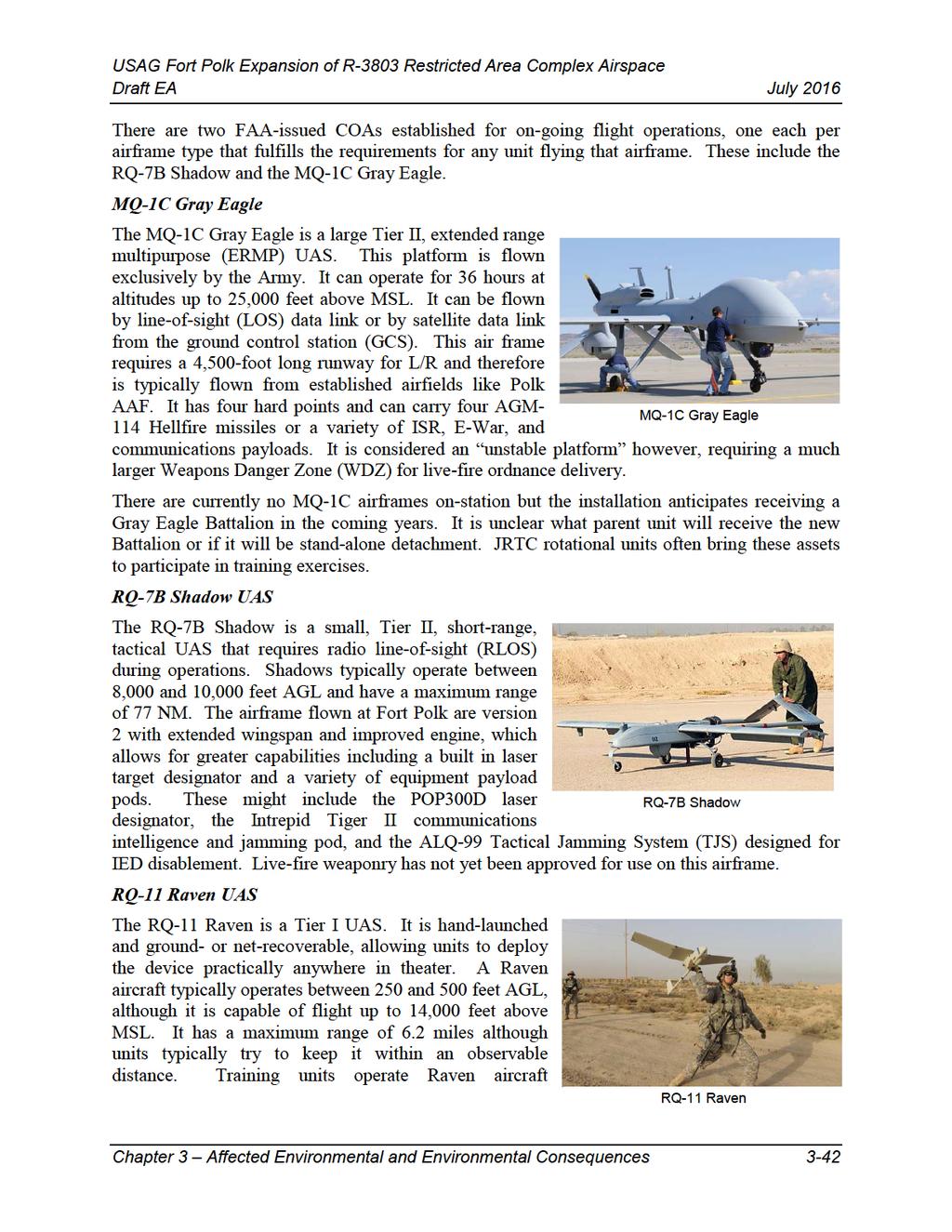
78
79
80 expanded RA there would be limitations as to what types of training could be conducted at Peason Ridge outside of existing RA, making it less useful for real-world scenarios and CALFEX training employing the latest and emerging technologies. These activities could still be conducted but within a very limited and congested area or within the R This level of congestion increases the possibility for unintentional conflict and/or limits the quantity and quality of exercises that can be conducted at any given time Supports Live-Fire Training Missions Live-fire training would be limited without use of the newly acquired land, equivalent to existing training levels. Airspace would be relatively unaffected with the exception of a minor increase in low-level rotary wing traffic in support of ground maneuvers in the newly acquired lands. This traffic would be in the Warrior 1 Low MOA and be controlled by the JACC Cell or Polk Approach Supports Realistic Battlefield Situational Awareness Without the use of airspace for ground fire and aerial gunnery, battlefield situational awareness would not be improved and would continue at existing levels. Rotary wing aircraft could provide observation and ISR, personnel transport, LZ and DZ activity, but no live fire. UAS could also be used to provide reconnaissance, ISR, and communications relay by employing the use of COAs, which would require chase planes. Both rotary wing aircraft and UAS are mandatory elements of realistic battlefield situational awareness but chase planes degrade the realism of drone use on the battlefield Supports Air Training Missions Air training would be limited over newly acquired land without expanded RA. Training levels would remain unchanged and congested within the existing RA boundaries Proposed Action Alternative 1 Establish Lower Altitude RA This alternative provides for the establishment of two independent but contiguous sections of RA over recently acquired property adjacent to the Peason Ridge training area and its associated RA identified as R-3803A & R-3803B. Each of the two proposed RA segments identified as R- 3803C & R-3803D would extend from ground up to but not including 18,000 feet above MSL, which is consistent with the adjacent R-3803A. It also includes establishing RA to encompass airspace above the area identified as the Exclusion area which consists of property not owned by the Army from 2,000 feet above MSL up to but not including 18,000 feet above MSL. Presently there are 18 private residences and other unoccupied but privately used land in this area including forested and agricultural land. Public roadways also traverse this area as well as the Army owned property including highway 117, which diagonally traverses the site northnortheast to south-southwest between the proposed R-3803C and the R-3803D (refer to Figure 1-1). As stated in Chapter 2, the exclusion area of non-ra would allow aerial access to privately owned lands and would provide adequate segregation from military training activities occurring above; eliminating the potential for significant adverse impacts from infringing upon private airspace rights directly above these private landholdings. Certain activities, such as private drone use within the exclusion area, could affect military training within the proposed RA above Chapter 3 Affected Environmental and Environmental Consequences 3-44

81 the exclusion area. Depending upon the sophistication of the drone equipment, private drone users may not be able to accurately discern altitude, location or know when the MOA or RA are active. Restricting airspace use between 1,201 feet above MSL and 18,000 feet above MSL would adversely affect the use of Victor route V-212 as the clearance corridor for this route intersects the RA. When the RA is activated (anticipated to be approximately 320 days per year) it would deny low-level users safe access to the air corridor. This condition however, currently exists as the V-212 route runs through the Warrior 1 MOA, prompting most users to fly over or around the area when it is activated. The high-level Jet route J50 would not be disrupted as it resides above 18,000 feet above MSL. Additionally, the use of Victor routes may soon diminish or go away all together with continued implementation of NextGen ATC. The FAA has determined that the establishment of R-3803C & R-3803D would have a negligible effect to traffic on these routes because they are not used on a frequent basis because aircraft are generally on direct routing (Regotti 2016). FAA estimates that establishment of the R-3803C & R-3803D would impact an average of 4.4 operations per day. Therefore, this alternative is considered to have only a minor impact to airspace use. A portion of the Class-E transitional area surrounding Prairie Creek Airport (57LS) would be converted to RA when the R-3803C is activated. The closest point of RA to the end of the runway of that private airfield is approximately 2.56 NM but not deemed a detriment to airport operations due to its relatively small size, number of operations and size of aircraft on station (refer to Section for details about this airport and to Figure for a depiction). Both entities (RA and Class-E airspace) are controlled by Polk Approach, which reduces the potential layers of control. Aircraft in pattern around Prairie Creek Airport may be required to slightly realign their approach pattern as the runway aligns with the southwest corner of the RA. Figure Prairie Creek Airport Supports Live-Fire Training Missions Table lists the desired elements of live-fire training missions defined in Chapter 2 that have an impact on airspace. This includes ground and air based live-fire systems and the vertical hazards justifying proposed RA requirements. Chapter 3 Affected Environmental and Environmental Consequences 3-45
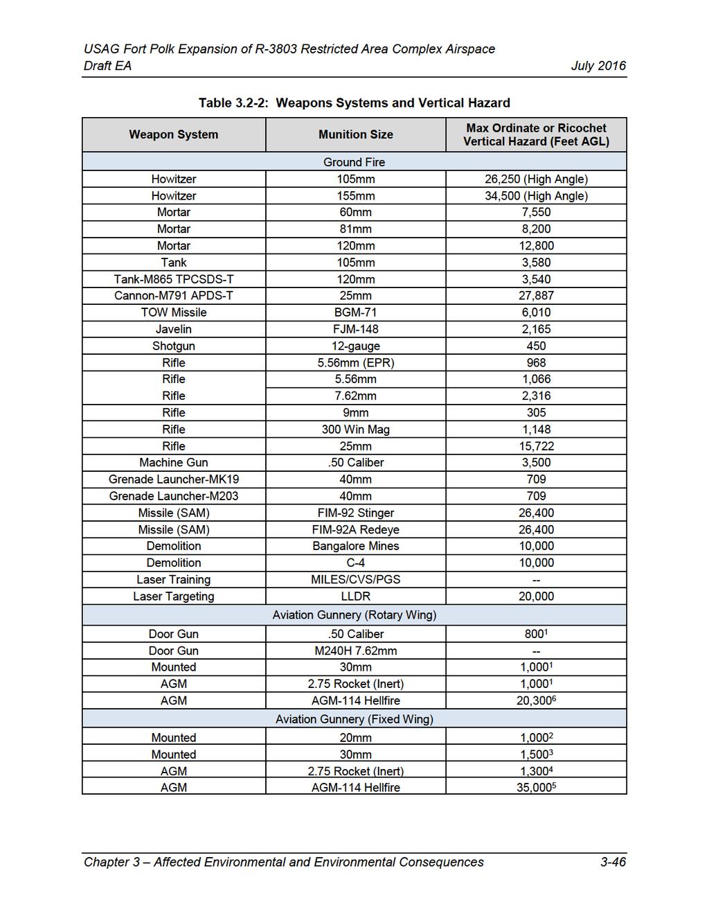
82
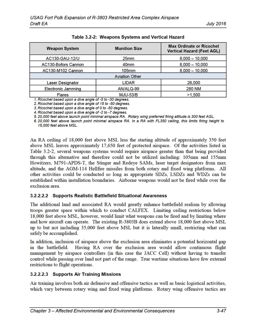
83
84 typically low-level activities including: CAS, SAT, SEAD/DEAD, aerial gunnery both mounted and door gunners, laser target designation, and E-War. Fixed wing offensive tactics can range from high-level to low-level and include aerial gunnery such as low-level strafing, AC130 big gun orbiting fire, AGM-missile launch from both low-level and high-level, laser target designation, and E-War. Fixed wing activities could also include UAS conducting laser target designation, and E-War. Rotary wing and fixed wing defensive tactics training could include defensive maneuvering, flare release, electronic frequency spectrum GPS jamming, IED jamming, and MEDEVAC. Basic logistics training activities for rotary wing aircraft includes LZ approach and departure, single wheel and sloped surface alighting, cargo and personnel DZ runs, aerial reconnaissance and ISR, FARP, nap of the earth, observation and basic flight training. All of these activities are conducted at low-level, well below 18,000 feet above MSL. Basic logistics training activities for fixed wing airframes includes short-field LZ launch and recovery, cargo and personnel DZ runs, parachute drops, observation and basic flight training. All low-level activities can freely be conducted within existing and proposed RA with no negative impacts to non-participating aircraft. Range Safety criteria require absolute control over weapons release. DoD jamming equipment blocks military grade equipment signals and would not affect typical household devices such as cell phones, television, or radio signals. High-level activities above 18,000 feet above MSL would be restricted to the existing R-3803B since the expanded RA of this alternative only goes to 18,000 feet above MSL. This elevation limit primarily affects fixed wing airframes. While this negatively limits training, it is of no impact to non-participating aircraft utilizing the J50 air corridor. Congestion within RA is a major consideration and operational limiting factor. Highly organized time and space separations would be necessary in order to deconflict the broad range of potential military activities planned Proposed Action Alternative 2 Establish Lower Altitude RA, Excluding the Airspace Above the Exclusion Area This alternative is similar to Alternative 1, except the airspace above the exclusion area would be excluded from being classified as RA with no ceiling. This airspace would remain as Warrior 1 Low MOA (down to 100 feet AGL) when the RA is activated or Class-E airspace (down to 1,200 feet AGL) when the MOA and RA are not activated. The same RA height limitations identified in Alternative 1 would also apply for this alternative, and therefore, impacts to the V-212 would be similar to those discussed under Alternative 1. Creating a column of full height open airspace between two sections of the training battlefield has a greater potential for airspace conflict between military and non-participating aircraft compared to Alternative 1. Protections provided by the MOA would reduce the likelihood of conflicts but does not strictly prohibit non-participating aircraft from entering this space at any altitude. If aircraft flew into this triangular area they would most likely not be able to exit without going into RA whether intentionally or unintentionally. For this reason this alternative is considered to have a moderate level of impact to airspace use. Chapter 3 Affected Environmental and Environmental Consequences 3-48
85 Supports Live-Fire Training Missions The ability of Alternative 2 to support live-fire training missions would be similar to Alternative 1. Airborne weapons could not be fired while over the exclusion area nor could ordnance be fired over the exclusion area through non-restricted airspace Supports Realistic Battlefield Situational Awareness The ability of Alternative 2 to support realistic battlefield situational awareness would be similar to Alternative 1. Impacts to military airspace use, however, would be slightly affected. The exclusion area creates a horizontal and vertical gap in the proposed RA. The presence of the exclusion area reduces realistic battlefield conditions and would present moderate impacts to military airspace use compared to Alternative 1 and 3. The same types of airspace use identified in the No Action Alternative could continue to operate within the exclusion area with or without RA Supports Air Training Missions The ability of Alternative 2 to support air training missions would be similar to Alternative 1 except that a gap would exist in the airspace between the two segments of RA (R-3803C & R3803D). This would necessitate a control handoff of aircraft passing between these RA segments under control of the JACC Cell through MOA airspace (if activated) under control of Polk Approach. The types of authorized activities would have similar requirements for appropriate SDZ and WDZ within installation boundaries. Additionally, weapon systems may not be armed while passing through this non-ra airspace Proposed Action Alternative 3 Establish Lower and High Altitudes (Preferred Alternative) This alternative includes the same proposed RA segments as Alternative 1 (R-3803C and R- 3803D, including the airspace above the exclusion area) with the addition of two other proposed RA segments, denoted R-3803E and R-3803F. R-3803-E resides directly above R-3803C and R- 3803F resides directly above R-3803D in matching lateral configuration, extending from 18,000 feet above MSL up to but not including 35,000 feet above MSL. When all six RA segments are activated, there would be contiguous protected airspace over the entire range. RA would not exist over the exclusion area from surface up to 2,000 feet above MSL. The same restrictions to use of the V-212 corridor exist as defined in Alternatives 1 and 2. Additional conflicts exist when either of these two RA are activated (R-3803E & R-3803F) with the high-level jet route J50 as it aligns with the low-level Victor route, V-212. The J50 would be only minorly affected because the projected usage rate of the R-3803E & R-3803F is only 20 days per year and usage rates of the J50 are very low at an average one operation per day. The existing R-3803B has a similar conflict with the J180, clipping the northwest corner with the 4- mile clearance width extending across half of R-3803B. This is an existing condition that would not change due to this action. The high-level Q route Q38 is above the proposed R-3803F, and therefore, should not be affected. The RA extends up to but not including 35,000 feet above MSL while the Q38 begins Chapter 3 Affected Environmental and Environmental Consequences 3-49
86 at FL350 and extends upwards. This alternative is considered to have only a minor impact to airspace use Supports Live-Fire Training Missions Compared to Alternatives 1 and 2, the additional vertical airspace provided by R3803E and R- 3803F would allow use of the addition of the following systems: 105mm Howitzers 155mm Howitzers M791-APDS-T Stinger SAM Redeye SAM Laser target designators AGM-114 Hellfire missiles from stabilized platforms. However, it has been determined that the WDZ required for a UAS launch of AGM-114 Hellfire missiles at altitude does not fit within installation boundaries, and therefore, would not be possible at Peason Ridge. Similar to live fire under the other alternatives, these systems (and all other live-fire weapons) would not be fired over the exclusion area. All require appropriate SDZs, LSDZs or WDZs, which must be plotted within installation boundaries. The use of AGM-114 Hellfire missiles must be fired from below 15,000 feet above MSL due to height limitations of RA not exceeding 35,000 feet above MSL. DA Pamphlet Range Safety, Sections and state that there must be a minimum 20,000 feet above the launch point. It is unclear if this also applies to the inert version of 2.75 rocket, but it is reasonably assumed to be included as the upward trajectory of a misguided missile could still take down an aircraft with or without a warhead Supports Realistic Battlefield Situational Awareness Similar to Alternative 1, inclusion of airspace above the exclusion area eliminates a potential horizontal and vertical gap in the battlefield. In addition, Alternative 3 would improve situational awareness and decrease potential congestion of a complex variety of simultaneous air activities by having the ability to restrict private and public use of the entire vertical range airspace (up to but not including 35,000 feet above MSL) Supports Air Training Missions Scheduling and coordination of air training activities would improve due to an additional 30 percent of available RA. The additional RA would allow for vertical separations of different activities, which increases safety and reduces congestion. This may have the effect of increasing training opportunities. In particular, this benefits high-altitude activities such as fixed wing bomb runs, ISR, laser targeting, missile launch, electronic warfare, and Tier II UAS flight training Proposed Action Alternative 4 Establish Lower and High Altitudes, Excluding the Airspace Above the Exclusion Area Alternative 4 is similar to Alternative 3 regarding vertical RA, however, similar to Alternative 2, it excludes the airspace above the exclusion area from being classified as RA. Impacts would be Chapter 3 Affected Environmental and Environmental Consequences 3-50
87 similar to vertical RA classification described under Alternative 3 and to area exclusion, described under Alternative 2. Similar to Alternative 2, this alternative is considered to have a moderate level impact to airspace use due to the greater potential for airspace conflict between military and non-participating aircraft Supports Live-Fire Training Missions Support of live-fire training missions would be similar to conditions described in Alternative 3 regarding live-fire capabilities Supports Realistic Battlefield Situational Awareness Support of realistic battlefield situational awareness would be similar to conditions described in Alternative 3. Similar to Alternative 2, however, restrictions of certain activities over the exclusion area would be an impediment to the realism of battlefield operations and would present moderate impacts to military airspace use compared to Alternative 1 and Supports Air Training Missions Support of air training missions would be similar to conditions described in Alternative 3 with the same exceptions noted in Alternative 2 regarding a vertical gap in protected airspace between the four proposed RAs (R-3803C/E & R-3803D/F) Cumulative Impacts This section discusses cumulative impacts of the Proposed Action Alternatives for airspace related issues. Although the projects identified in Section would not add to adverse cumulative impacts to airspace, in general it can be expected that air traffic would increase through establishment of RA over the expanded Peason Ridge range complex, the MOA, and area surrounding the complex. This potential cumulative increase of military airspace use would be a result of future training facilities within the newly acquired lands. Increased military traffic would result in cumulative minor to moderate negative impacts to commercial and recreational aircraft operating in the ROI. In both Alternatives 2 and 4, the impact of increasing the impediment of the V-212 and J50 by activating both stratifications of RA (surface up to but not including 18,000 feet above MSL and 18,000 feet above MSL up to but not including 35,000 feet above MSL) reduces the options for rerouting aircraft using those airways. The activation of the existing R-3803A and R-3803B would eliminate the only possible existing route around the impediment (J180-J58) as it is not feasible to route aircraft over the RA. Anticipated implementation of NextGen ATC however, may reduce or eliminate the issue by routing aircraft from point-to-point without the need for established air corridors. Establishment of protected airspace could increase usage for UAS training in the future as an emerging technology in modern warfare. Without proper launch and recovery facilities located at Peason Ridge, this would result in increased requirements for COAs and chase planes to ferry aircraft to-and-from Polk AAF. This would not only increase traffic in that airspace but increase paperwork to file and manage the COAs and expense in hiring chase flights. Chapter 3 Affected Environmental and Environmental Consequences 3-51
88 While the Army will evaluate specific training infrastructure and locations within the new range area in future NEPA analyses, it is known that training activities will be conducted on the new ranges in a similar fashion to existing training activities at Peason Ridge. This may include artillery and mortar fire from new firing points established in the new range area to existing impact areas on Peason Ridge. It will likely include additional CAS, BSA, SEAD/DEAD, SAT, MEDEVAC, laser operations, E-War, EOD, flare drop, smoke, LZ and DZ use, FARP and UAS operations. None of these activities will disrupt the use of airspace by non-participating aircraft if conducted within the proposed expanded RA. Additionally, this proposed RA is completely surrounded by the existing Warrior MOA providing additional protections should activities extend beyond RA boundaries. These increased training opportunities would likely increase military airspace traffic to and from the range. This additional traffic may be considered as having a minor cumulative impact on non-ra airspace, but not outside of the Warrior MOAs. The non-restricted airspace separating the two RA groups R-3803 & R-3804, along with the recent expansion of the R-3804B in conjunction with the Proposed Action would considerably decrease. This decrease in non-restricted airspace combined with an anticipated increase in traffic between these two areas could potentially create a minor negative impact to nonparticipating aircraft. The minor rating is qualified by the fact that the Warrior MOA would be activated at all times of heightened military training activity. Chapter 3 Affected Environmental and Environmental Consequences 3-52
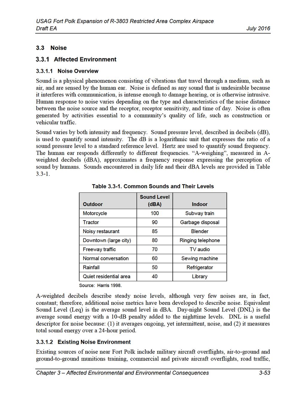
89
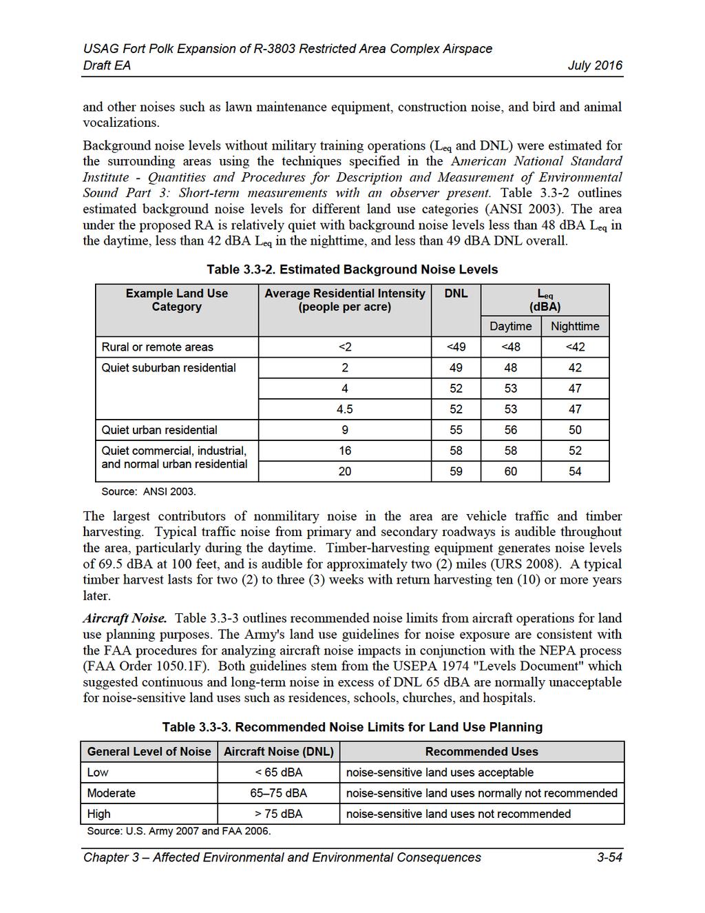
90
91 Aircraft operations at the installation are concentrated at Polk Army Airfield, and in the training areas at landing zones, drop zones, and along established flight corridors. Areas above 65 dba DNL adjacent to Polk Army Airfield are contained within the installation boundary, and do not overlap any noise sensitive areas. Noise levels beneath all flight corridors and landing/drop zones at the installation are below 65 dba DNL. Although persons living in the immediate vicinity of a flight corridor or landing zones could be annoyed during periods of peak activity, current land use within these areas is completely compatible with the existing noise environment (URS 2008). Other than 18 residences and additional unoccupied privately-owned lands in the exclusion area, portions underlying the proposed RA consist of entirely of newly acquired Army lands. The area is frequented by fixed-wing and rotary-wing military aircraft, and includes part of a flight corridor between Fort Polk Main Post and Peason Ridge. Although current training activity is not sufficient to produce annual noise levels greater than 65 dba DNL, predicted busy-day DNL is 63.4 dba under the flight corridor between Fort Polk and Peason Ridge (URS 2008). Large Arms and Heavy Artillery Noise. Noise generated by the detonation of large projectiles, missiles, and bombs near the proposed RA is concentrated at live-fire ranges, firing points, and impact areas in the northern portions of Peason Ridge. This noise is audible, but distant, in areas under the proposed RA. Noise normally not recommended for sensitive land uses associated with existing training do not extend into the newly acquired lands or the exclusion area, and do not overlap any residences, schools, hospitals, or churches (URS 2008). Noise Complaint and Mitigation Programs. The Fort Polk Public Affairs Office maintains a 24-hour hotline to receive noise complaints associated with military training operations. Complaint resolution has included adjustments to helicopter and fixed-wing aircraft flight paths and reductions in detonation charge weights. In addition, Fort Polk operates a noise abatement program, which is designed to address noise complaints raised by the public. In the 1990's, complaints averaged five or six per month; however, operational noise management practices have dramatically reduced complaints to almost none in recent years. Isolated noise complaints are sometimes still received, and every year or two several complaints may be received after a single loud training event. Environmental Consequences Effects would be considered significant if the Proposed Action were to (1) result in the violation of applicable federal, state, or local noise regulation; or (2) create appreciable areas of incompatible land use off post. Table provides a comparison summary of anticipated level of impacts to each of the four Proposed Action Alternatives and the No Action Alternative. Chapter 3 Affected Environmental and Environmental Consequences 3-55
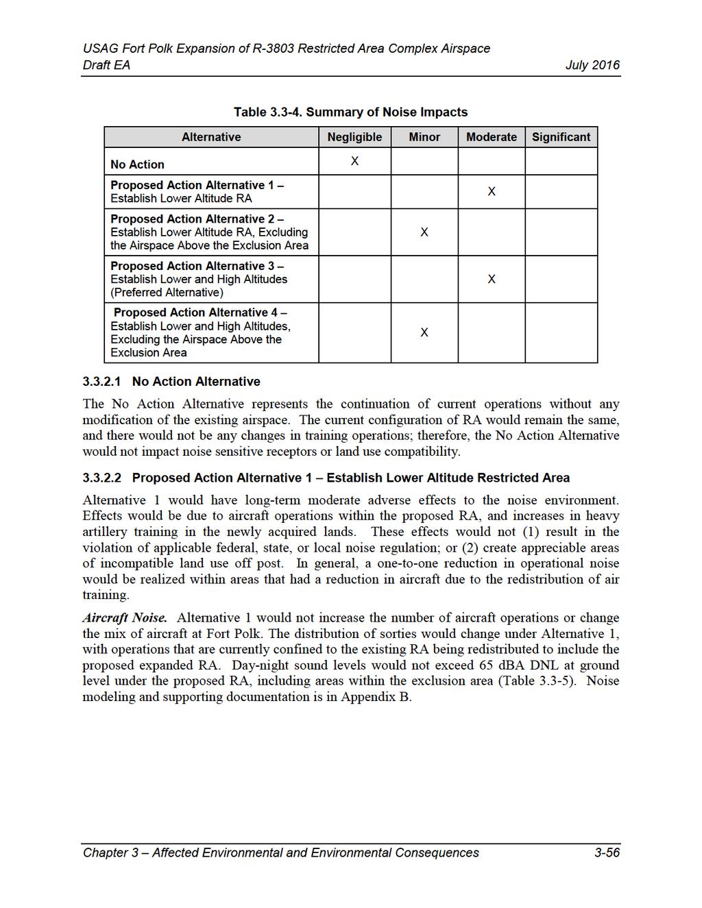
92
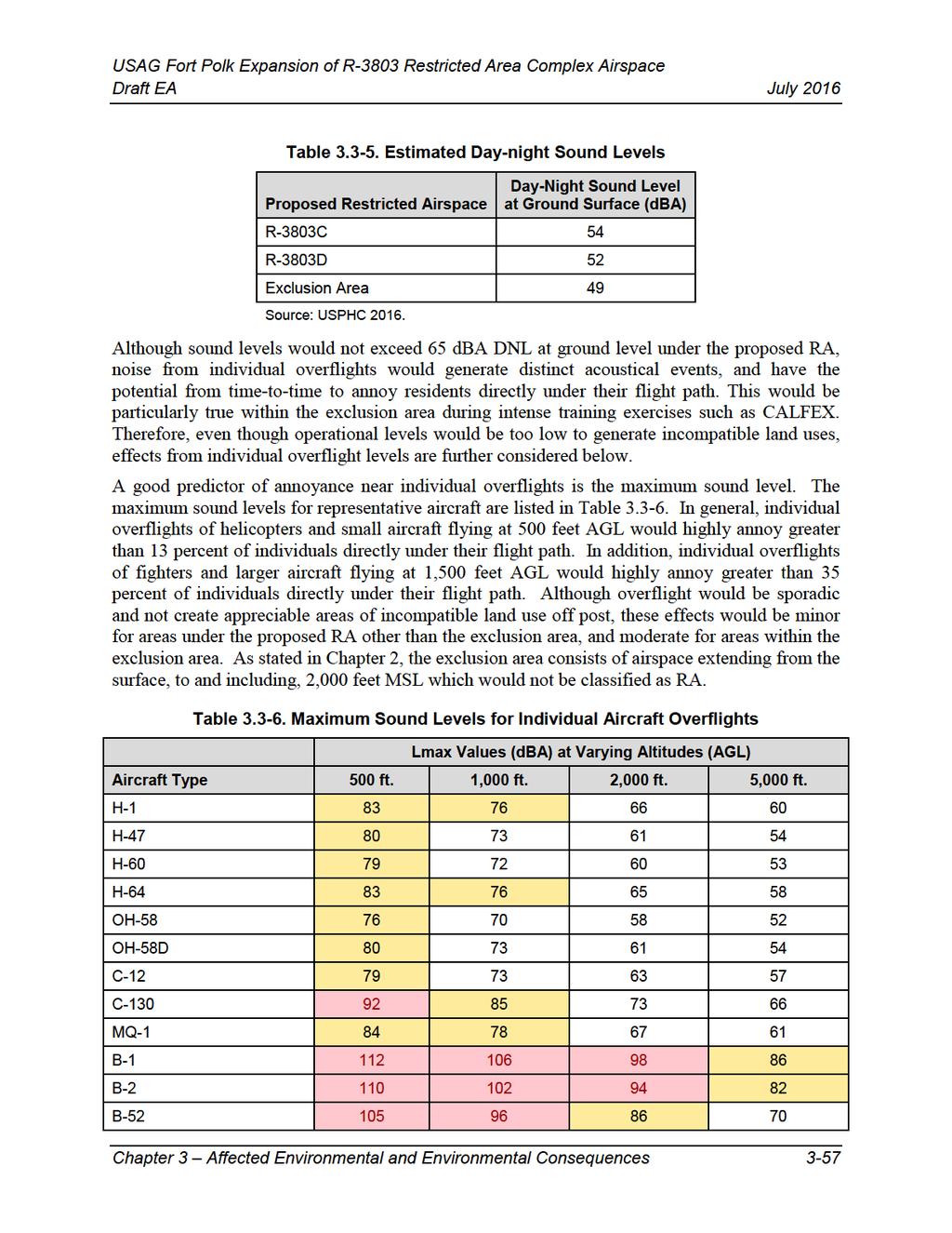
93
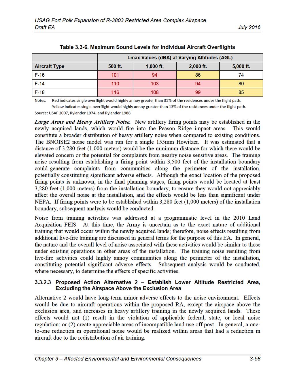
94
95 Similar to Alternative 1, Alternative 2 would not increase the number of aircraft operations or change the mix of aircraft at Fort Polk. The distribution of sorties would change under Alternative 2, with operations that are currently confined to the existing RA being redistributed to include the proposed expanded RA, except the airspace above the exclusion area. Day-night sound levels would not exceed 65 dba DNL at ground level under the proposed RA (Table 3.4-1). As with Alternative 1, individual aircraft overflights could from time-to-time annoy individuals; however, there would be no additional low-level overflights over individuals or residences within the exclusion area when compared to existing conditions. These effects would be minor. Effects from large arms and heavy artillery noise would be similar in nature and overall level as Alternative 1. Additional training noise resulting from firing points established within 3,280 feet (1,000 meters) of the installation boundary and any other live fire activities could highly annoy communities along the perimeter of the installation, constituting potential significant adverse effects. Subsequent analysis would be conducted, where necessary, to determine the effects of specific activities Proposed Action Alternative 3 Establish Lower and High Altitudes (Preferred Alternative) Alternative 3 would have long-term moderate adverse effects. Effects would be due to aircraft operations within the proposed RA, including the airspace above the exclusion area, and increases in heavy artillery training in the newly acquired lands. These effects would not (1) result in the violation of applicable federal, state, or local noise regulation; or (2) create appreciable areas of incompatible land use off post. In general, a one-to-one reduction in operational noise would be realized within areas that had a reduction in aircraft due to the redistribution of air training. Effects from aircraft noise would be similar in nature and overall level as Alternative 1. Daynight sound levels would not exceed 65 dba DNL at ground level under the proposed RA (Table 3.4-1). As with Alternative 1, low-level aircraft overflights could from time-to-time annoy individuals, and in particular residences within the exclusion area. High-altitude overflights (i.e. greater than 18,000 feet MSL) would be audible, but distant. They would not change the overall DNL at ground level or annoy individuals or residences under their flight path. Similar to Alternative 1, the exclusion area would extend from the surface, to and including, 2,000 feet MSL which would not be classified as RA. Overall effects to the noise environment would be moderate. Effects from large arms and heavy artillery noise would be similar in nature and overall level as Alternative 1. Additional training noise resulting from firing points established within 3,280 feet (1,000 meters) of the installation boundary and any other live fire activities could highly annoy communities along the perimeter of the installation, constituting potential significant adverse effects. Subsequent analysis would be conducted, where necessary, to determine the effects of specific activities Proposed Action Alternative 4 Establish Lower and High Altitudes, Excluding the Airspace Above the Exclusion Area Alternative 4 would have long-term minor adverse effects. Effects would be due to aircraft operations within the proposed RA, except the airspace above the exclusion area, and increases Chapter 3 Affected Environmental and Environmental Consequences 3-59
96 in heavy artillery training in the newly acquired lands. These effects would not (1) result in the violation of applicable federal, state, or local noise regulation; or (2) create appreciable areas of incompatible land use off post. In general, a one-to-one reduction in operational noise would be realized within areas that had a reduction in aircraft due to the redistribution of air training. Effects from aircraft noise would be similar in nature and overall level as Alternative 2. Daynight sound levels would not exceed 65 dba DNL at ground level under the proposed RA (Table 3.4-1). As with Alternative 1, low-level aircraft overflights could from time-to-time annoy individuals; however, there would be no additional low-level overflights over individuals or residences within the exclusion area when compared to existing conditions. High-altitude overflights (i.e. greater than 18,000 feet MSL) would be audible, but distant. They would not change the overall DNL at ground level or annoy individuals or residences under their flight path. These effects would be minor. Effects from large arms and heavy artillery noise would be similar in nature and overall level as Alternative 1. Additional training noise resulting from firing points established within 3,280 feet (1,000 meters) of the installation boundary and any other live fire activities could highly annoy communities along the perimeter of the installation, constituting potential significant adverse effects. Subsequent analysis would be conducted, where necessary, to determine the effects of specific activities. Cumulative Effects The Proposed Action would introduce long-term minor to moderate increases to the noise environment. All noise associated with the Proposed Action would be in addition to other ongoing air operations and military training activities in the area. Overall, these increases would be relatively minor and have a negligible cumulative effect on the overall noise environment. Chapter 3 Affected Environmental and Environmental Consequences 3-60
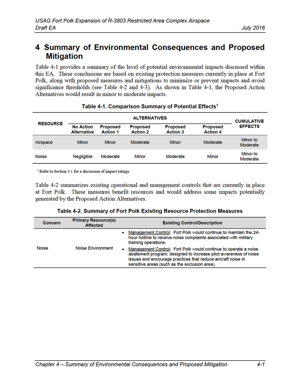
97
98
99 1 2 5 Acronyms 05LS 1R4 2L0 34LA 3R4 4XS5 57LS 5LS9 61R 6LA4 70LA 9LA6 AA AAF AAR ABC ACP ADA ADCS ADP ADRP AEX AFB AGL Grass Roots Airport Woodworth Airport Pineville Municipal Airport Swamp Smith Airport Hart Airport Scrappin Valley Airport Prairie Creek Airport Ammons Airport Newton Municipal Airport Dyer Airport Roland Airport Chandler Airport assembly area Army Airfield After Action Report air battle captain Allen Parish Airport air defense artillery Approach-Departure Control Surface Army Doctrine Publication Army Doctrine Reference Publication Alexandria International Airport Air Force Base Above Ground Level Chapter 5 Acronyms 5-1
100 ANSI APDS-T ATC ATCAA ATGM BCT BSA BT CALFEX CAS CATS COA CTC CVS db dba DFW DME DNL DoD DRI DZ EIS EO EOD ERMP American National Standard Institute armor-piercing discarding sabot with tracer Air Traffic Control Air Traffic Control Assigned Airspace antitank guided missile Brigade Combat Team basic surface attack battalion train Combined Arms Live Fire Exercises close air support Combined Arms Training Strategies certificate of authorization Combat Training Center Combat Vehicle System decibel A-weighted decibel Dallas-Fort Worth International Airport Distance measuring equipment day-night sound level Department of Defense Beauregard Regional Airport Drop Zone Environmental Impact Statement Executive Order explosive ordinance disposal extended range multipurpose Chapter 5 Acronyms 5-2
101 ESF E-War FA FAC FARP FIST FL FLS FM FNSI FPPA FSO FY GCS GGG GIS GPS HALO HAR IER IFR ILS ISA ISB ISR IUA Esler Regional Airport electronic warfare field artillery forward air controller forward arming and refueling point fire support elements and fire support teams Flight Level Flight Landing Strip Field Manual Finding of No Significant Impact Farmland Protection Policy Act fire support officer Fiscal year ground control station East Texas Regional Airport Geographic Information Systems global positioning satellite high-altitude low open High altitude routing Natchitoches Regional Airport Instrument Flight Rules instrument landing system International Standard Atmosphere Intermediate Staging Base intelligence, surveillance, and reconnaissance Intensive Use Area Chapter 5 Acronyms 5-3
102 JAAT JACC JRTC JTAC JO km L/R L39 L66 LA35 LAANG L eq LFX LOS LSDZ LUA LZ MEA MEDEVAC MILES MOA MOU MSL NAS NAVAIDS NM Joint Air Attack Team Joint Aviation Control Center Joint Readiness Training Center Joint Terminal Attack Controllers Joint Order kilometer Launch/recovery Leesville Airport Polluck Municipal Airport Summerville Airstrip Louisiana Army National Guard equivalent sound level live fire exercises Line-of-sight Laser surface danger zone Limited Use Area Landing zone minimum enroute altitude medical evacuation Multiple Integrated Laser Engagement System Military Operation Area Memorandum of Understanding Mean Sea Level National Airspace System navigational aids Nautical miles Chapter 5 Acronyms 5-4
103 NOI NOTAM NRR PGS POE PPP RA RLOS RNAV ROI ROZ RPA RSTA RTU SAT SCAR SDZ SEAD/DEAD SLUA SME SUA T24 TPCSDS-T TJS TOC TUASOF Notice of Intent Notices to Airmen non-restrictive routing Precision Gunnery System Polk Army Airfield Power Projection Platform Restricted Area (airspace) radio line-of-sight Area Navigation Region of Influence restricted operational zone remotely piloted aircraft reconnaissance, surveillance, targeting, and acquisition Rotational Training Unit surface attack tactics strike, coordination and reconnaissance Surface danger zone suppression/destruction of enemy air defenses Special Limited Use Area Subject Matter Expert Special Use Airspace Pineland Municipal Airport target practice cone stabilized discarding sabot tracer Tactical Jamming System Tactical Operation Center Tactical Unmanned Aerial System Operations Facility Chapter 5 Acronyms 5-5
104 UA UAS U.S. USACE USAF USEPA USFS USPHC VEC VFR VOR VORTAC WDZ ZFW ZHU Unmanned aircraft unmanned aerial systems United States U.S. Army Corps of Engineers U.S. Air Force U.S. Environmental Protection Agency U.S. Forest Service U.S. Army Public Health Command Valued Environmental Component Visual Flight Rules very high frequency omnidirectional range Very High Frequency Omni-Directional Range/Tactical Aircraft Control Weapons Danger Zones Fort Worth Center Houston Center Chapter 5 Acronyms 5-6
105 6 References American National Standard Institute (ANSI) American National Standard Quantities and Procedures for Description and Measurement of Environmental Sound. Part 3: Short-term measurements with an observer present. ANSI S (R2013)/Part 3. Federal Aviation Administration (FAA). 2015a. FAA Order F - Environmental Impacts: Policies and Procedures. URL: FAA. 2015b. National Airspace Overview (NAS). Prepared by: FAA Telecommunications Infrastructure (FTI)-2 Program Office, AJM August. traffic/technology/cinp/fti2/documents/media/nas overview.pdf. Harris, C.M Handbook of Acoustical Measurement and Noise Control. Acoustical Society of America. Sewickley, PA. Regotti, Kristi. Federal Aviation Administration. Communication Letter between the FAA and Fort Polk dated 26 January Rylander, et al Reanalysis of Aircraft Noise Annoyance Data Against the dba Peak Concept. J. Sound and Vibration (36): Rylander and Bjorkman Maximum Noise Levels as Indicators of Biological Effects. J. Sound and Vibration (127): U.S. Air Force (USAF) SELCalc2 Aircraft Noise Model, Version U.S. Army ADRP 3-0. Unified Land Operations. Headquarters, Department of the Army. May. U.S. Army AR Army Regulation Environmental Quality Environmental Protection and Enhancement. URL: Accessed March U.S. Army FM Field Artillery Gunnery. Headquarters, Department of the Army. July. GUNNERY.pdf. U.S. Army Public Health Command (USAPHC) Operational Noise Consultation, WS a-16, Operational Noise Assessment, Proposed Restricted Airspace Expansions, Fort Polk, Louisiana, 16 February 2016 (Draft). USEPA Consideration of Cumulative Impacts in EPA Review of NEPA Documents. Office of Federal Activities. EPA 315-R May USEPA Information on Levels of Environmental Noise Requisite to Protect Public Health and Welfare with an Adequate Margin of Safety. URS JRTC AND Fort Polk Installation Operational Noise Management Plan. Chapter 6 References 6-1
106 This Page Intentionally Left Blank Chapter 6 References 6-2
107 7 List of Preparers Potomac-Hudson Engineering, Inc. Naumann, Robert M.S. Environmental Management B.S. Resource, Ecology and Management Years Experience: 17 Shinkle, Deborah B.A. Environmental Studies Years Experience: 12 DiPaolo, Paul B.S. Environmental Science and Policy Years Experience: 6 LPES Lavallee, Timothy M.S. Civil/Environmental Engineering B.S. Mechanical Engineering Years Experience: 23 Chapter 7 List of Preparers 7-1
108 Rexroad APG Rexroad, Joe B.A. Architecture & Urban Design Years Experience: 27 This Page Intentionally Left Blank Chapter 7 List of Preparers 7-2
109 Appendix A Public Involvement Appendix A Public Involvement A-1
110 This Page Intentionally Left Blank Appendix A Public Involvement A-2

111 Appendix A Public Involvement A-3


112 USAG Fort Polk Expansion of R-3803 Restricted Area Complex Airspace Draft EA Appendix A Public Involvement July 2016 A-4
113 Appendix B Supporting Noise Documentation Appendix B Supporting Noise Documentation B-1
114 This Page Intentionally Left Blank Appendix B Supporting Noise Documentation B-2
115 Appendix B Supporting Noise Documentation B-3
116 Appendix B Supporting Noise Documentation B-4
117 Appendix B Supporting Noise Documentation B-5
118 Appendix B Supporting Noise Documentation B-6
119 Appendix B Supporting Noise Documentation B-7

120 Appendix B Supporting Noise Documentation B-8
121 Appendix B Supporting Noise Documentation B-9
122 Appendix B Supporting Noise Documentation B-10
123 Appendix B Supporting Noise Documentation B-11
124 Appendix B Supporting Noise Documentation B-12
125 Appendix B Supporting Noise Documentation B-13

126 Appendix B Supporting Noise Documentation B-14
What Is The 29Palms Training Land Acquisition and Airspace Establishment Project Frequently Asked Questions Airspace Related July 2015
 MARINE CORPS / DEPARTMENT OF THE NAVY SUBMIT SPECIAL USE AIRSPACE PROPOSALS TO THE FEDERAL AVIATION ADMINISTRATION TO MEET MARINE EXPEDITIONARY BRIGADE TRAINING REQUIREMENTS 1. Why has the Marine Corps
What Is The Proposed 29Palms Training Land Acquisition and Airspace Establishment Project? Frequently Asked Questions Airspace Related June 2014
 MARINE CORPS / DEPARTMENT OF THE NAVY SUBMIT SPECIAL USE AIRSPACE PROPOSALS TO THE FEDERAL AVIATION ADMINISTRATION TO MEET MARINE EXPEDITIONARY BRIGADE TRAINING REQUIREMENTS 1. Why has the Marine Corps
Airspace Establishment Project Frequently Asked Questions Permanent SUA and Environmental Assessment March 2019
 OVERVIEW OF PERMANENT SPECIAL USE AIRSPACE ESTABLISHMENT AND MODIFICATIONS AT MARINE AIR GROUND TASK FORCE TRAINING COMMAND, TWENTYNINE PALMS, CA 1. What is Special Use Airspace (SUA)? Special Use Airspace
Proposed Establishment of and Modification to Restricted Areas; Fort Sill, OK
 This document is scheduled to be published in the Federal Register on 10/19/2015 and available online at http://federalregister.gov/a/2015-26499, and on FDsys.gov 4910-13 DEPARTMENT OF TRANSPORTATION Federal
DRAFT ENVIRONMENTAL ASSESSMENT FOR THE CREATION OF RESTRICTED AREA (RA) R-5601G AND R-5601H FORT SILL, OKLAHOMA
 R-5601G AND R-5601H FORT SILL, OKLAHOMA") DRAFT ENVIRONMENTAL ASSESSMENT FOR THE CREATION OF RESTRICTED AREA (RA) R-5601G AND R-5601H FORT SILL, OKLAHOMA Prepared by: Leidos Engineering, LLC Prepared for: U.S. Army Corps of Engineers, Tulsa District
DRAFT ENVIRONMENTAL ASSESSMENT FOR THE CREATION OF RESTRICTED AREA (RA) R-5601G AND R-5601H FORT SILL, OKLAHOMA Prepared by: Leidos Engineering, LLC Prepared for: U.S. Army Corps of Engineers, Tulsa District
4.2 AIRSPACE. 4.2 Airspace. Supplemental Draft Environmental Impact Statement August 2008 Military Training Activities at Mākua Military Reservation
 4.2 AIRSPACE 4.2.1 Impact Methodology Impacts on airspace use were assessed by evaluating the potential effects of the proposed training activities on the principal attributes of airspace use, as described
Department of Defense DIRECTIVE
 Department of Defense DIRECTIVE NUMBER 5030.61 May 24, 2013 Incorporating Change 2, August 24, 2017 USD(AT&L) SUBJECT: DoD Airworthiness Policy References: See Enclosure 1 1. PURPOSE. This directive establishes
DRAFT ENVIRONMENTAL ASSESSMENT FOR THE MODIFICATION OF SPECIAL USE AIRSPACE FORT BLISS, TEXAS AND NEW MEXICO
 DRAFT ENVIRONMENTAL ASSESSMENT FOR THE MODIFICATION OF SPECIAL USE AIRSPACE FORT BLISS, TEXAS AND NEW MEXICO Prepared for: FORT BLISS Prepared by: Directorate of Public Works Environmental Division, Fort
STUDY OVERVIEW MASTER PLAN GOALS AND OBJECTIVES
 INTRODUCTION An Airport Master Plan provides an evalua on of the airport s avia on demand and an overview of the systema c airport development that will best meet those demands. The Master Plan establishes
April 5, Dear Mr. Ready,
 50 F St. NW, Suite 750 Washington, D.C. 20001 T. 202-737-7950 F. 202-273-7951 www.aopa.org Mr. Kenneth Ready U.S. Department of Transportation Docket Operations 1200 New Jersey Avenue SE. West Building
Amendment of Restricted Areas R-3004A and R-3004B and Establishment of R-3004C;
 This document is scheduled to be published in the Federal Register on 09/25/2017 and available online at https://federalregister.gov/d/2017-20435, and on FDsys.gov 4910-13 DEPARTMENT OF TRANSPORTATION
Alternatives. Introduction. Range of Alternatives
 Alternatives Introduction Federal environmental regulations concerning the environmental review process require that all reasonable alternatives, which might accomplish the objectives of a proposed project,
UNMANNED AIRCRAFT PROVISIONS IN FAA REAUTHORIZATION BILL
 UNMANNED AIRCRAFT PROVISIONS IN FAA REAUTHORIZATION BILL Section 341 Comprehensive Plan -Codifies in title 49 the requirement in the 2012 FAA reauthorization Act that a comprehensive plan to safely accelerate
Amendment of Restricted Areas R-2907A and R-2907B, Lake George, FL; and R-2910, Pinecastle, FL
 This document is scheduled to be published in the Federal Register on 07/03/2013 and available online at http://federalregister.gov/a/2013-16054, and on FDsys.gov 4910-13 DEPARTMENT OF TRANSPORTATION Federal
DEPARTMENT OF TRANSPORTATION FEDERAL AVIATION ADMINISTRATION ADOPTION OF ENVIRONMENTAL IMPACT STATEMENT AND FAA RECORD OF DECISION FOR
 DEPARTMENT OF TRANSPORTATION FEDERAL AVIATION ADMINISTRATION ADOPTION OF ENVIRONMENTAL IMPACT STATEMENT AND FAA RECORD OF DECISION FOR Establishment of the Powder River Training Complex Located in Montana,
CHAPTER 1: INTRODUCTION
 CHAPTER 1: INTRODUCTION Purpose and Scope The information presented in this report represents the study findings for the 2016 Ronan Airport Master Plan prepared for the City of Ronan and Lake County, the
Airports and UAS: Managing UAS Operations in the Airport Vicinity
 ACRP Problem Statement 17-10-09 Recommended Allocation: $350,000 Airports and UAS: Managing UAS Operations in the Airport Vicinity ACRP Staff Comments This is one of four UAS-themed problem statements
SUMMARY REPORT ON THE SAFETY OVERSIGHT AUDIT FOLLOW-UP OF THE DIRECTORATE GENERAL OF CIVIL AVIATION OF KUWAIT
 ICAO Universal Safety Oversight Audit Programme SUMMARY REPORT ON THE SAFETY OVERSIGHT AUDIT FOLLOW-UP OF THE DIRECTORATE GENERAL OF CIVIL AVIATION OF KUWAIT (Kuwait, 17 to 20 September 2003) International
Effective Altitude. R-3103 To 30,000 (To 9,144 meters) Source: NACO 2002 Notes: 1 By NOTAM issued 12 hours in advance
 Source: NACO 2002 Notes: 1 By NOTAM issued 12 hours in advance") 8.4 AIRSPACE USE 8.4.1 Affected Environment The affected airspace environment is described below in terms of its principal attributes, namely controlled and uncontrolled airspace, special use airspace,
8.4 AIRSPACE USE 8.4.1 Affected Environment The affected airspace environment is described below in terms of its principal attributes, namely controlled and uncontrolled airspace, special use airspace,
REPORT 2014/065 INTERNAL AUDIT DIVISION. Audit of air operations in the United. Nations Assistance Mission in Afghanistan
 INTERNAL AUDIT DIVISION REPORT 2014/065 Audit of air operations in the United Nations Assistance Mission in Afghanistan Overall results relating to the effective management of air operations in the United
FUTENMA REPLACEMENT FACILITY BILATERAL EXPERTS STUDY GROUP REPORT. August 31, 2010
 FUTENMA REPLACEMENT FACILITY BILATERAL EXPERTS STUDY GROUP REPORT August 31, 2010 MANDATE AND SCOPE OF WORK: In order to achieve the earliest possible relocation of Marine Corps Air Station Futenma, the
CHG 0 9/13/2007 VOLUME 2 AIR OPERATOR AND AIR AGENCY CERTIFICATION AND APPLICATION PROCESS
 VOLUME 2 AIR OPERATOR AND AIR AGENCY CERTIFICATION AND APPLICATION PROCESS CHAPTER 5 THE APPLICATION PROCESS TITLE 14 CFR PART 91, SUBPART K 2-536. DIRECTION AND GUIDANCE. Section 1 General A. General.
COMPLIANCE WITH THIS PUBLICATION IS MANDATORY
 BY ORDER OF THE SECRETARY OF THE AIR FORCE AIR FORCE MANUAL 13-215 VOLUME 1 11 FEBRUARY 2019 Nuclear, Space, Missile, Command, and Control AIRFIELD OPERATIONS DATA SYSTEMS COMPLIANCE WITH THIS PUBLICATION
Airports and UAS: Integrating UAS into Airport Infrastructure and Planning
 ACRP Problem Statement 17-03-09 Recommended Allocation: $500,000 Airports and UAS: Integrating UAS into Airport Infrastructure and Planning ACRP Staff Comments This is one of four UAS-themed problem statements
CIVIL AVIATION REGULATIONS PART 10 COMMERCIAL AIR TRANSPORT BY FOREIGN AIR OPERATORS WITHIN FEDERATED STATES OF MICRONESIA
 CIVIL AVIATION REGULATIONS PART 10 COMMERCIAL AIR TRANSPORT BY FOREIGN AIR OPERATORS WITHIN FEDERATED STATES OF MICRONESIA FEDERATED STATES OF MICRONESIA 2001 [THIS PAGE INTENTIONALLY LEFT BLANK] 10-ii
Public Comment on Condor MOA Proposal
 Public Comment on Condor MOA Proposal Michael Wells, Lt. Colonel (retired) P.O. Box 274 Wilton, ME 04294 20 November, 2009 1. As a retired Air Force Lt. Colonel, squadron commander, F-15 Instructor Pilot,
FLIGHT PATH FOR THE FUTURE OF MOBILITY
 FLIGHT PATH FOR THE FUTURE OF MOBILITY Building the flight path for the future of mobility takes more than imagination. Success relies on the proven ability to transform vision into reality for the betterment
TWELFTH AIR NAVIGATION CONFERENCE
 International Civil Aviation Organization 17/5/12 WORKING PAPER TWELFTH AIR NAVIGATION CONFERENCE Montréal, 19 to 30 November 2012 Agenda Item 4: Optimum Capacity and Efficiency through global collaborative
Chapter 1 Introduction and Project Overview
 Chapter 1 Introduction and Project Overview Kittitas County in cooperation with the Federal Aviation Administration (FAA) is updating the Airport Master Plan for Bowers Field Airport (FAA airport identifier
REPORT 2014/111 INTERNAL AUDIT DIVISION. Audit of air operations in the United Nations Operation in Côte d Ivoire
 INTERNAL AUDIT DIVISION REPORT 2014/111 Audit of air operations in the United Nations Operation in Côte d Ivoire Overall results relating to the effective management of air operations in the United Nations
Civil/Military Coordination Workshop Havana, Cuba April 2015
 Civil/Military Coordination Workshop Havana, Cuba 13-17 April 2015 Civil/Military Coordination in the United States based on Appendix A of ICAO Circular 330 Dave Edwards, U.S. Coast Guard Chairman, ICAO/International
Windmills & Airspace Can We Work Together?
 May 29, 2008 Windmills & Airspace Can We Work Together? J. Randolph Babbitt C O N F I D E N T I A L www.oliverwyman.com Windmills & Airspace Overview of Airspace Issues For Wind Turbine Sites The FAA s
APPENDIX I AIRSPACE TECHNICAL MEMO
 APPENDIX I AIRSPACE TECHNICAL MEMO Table of Contents 1.0 INTRODUCTION... 1 1.1 AIRSPACE REGULATORY FRAMEWORK... 7 1.2 RESOURCE DEFINITION... 7 1.3 DESCRIPTION OF PROPOSED SPECIAL USE AIRSPACE AND TRAINING
Report to Congress Aviation Security Aircraft Hardening Program
 Report to Congress Aviation Security Aircraft Hardening Program Washington, DC 20591 December 1998 Report of the Federal Aviation Administration to the House and Senate Committees on Appropriations pursuant
COMMISSION OF THE EUROPEAN COMMUNITIES. Draft. COMMISSION REGULATION (EU) No /2010
 No /2010") COMMISSION OF THE EUROPEAN COMMUNITIES Brussels, XXX Draft COMMISSION REGULATION (EU) No /2010 of [ ] on safety oversight in air traffic management and air navigation services (Text with EEA relevance)
COMMISSION OF THE EUROPEAN COMMUNITIES Brussels, XXX Draft COMMISSION REGULATION (EU) No /2010 of [ ] on safety oversight in air traffic management and air navigation services (Text with EEA relevance)
Safety, Infrastructure, and Tenant Improvement Project. Public Hearing Informational Brochure February 26, 2013
 New York State Department of Transportation Safety, Infrastructure, and Tenant Improvement Project Public Hearing Informational Brochure February 26, 2013 This DEIS/Draft EA evaluates the potential impacts
4.6 AIRSPACE. Approach to Analysis
 4.6 AIRSPACE Section 4.6 describes the impacts that could potentially occur to the existing airspace environment from the proposed action. Potential impacts would stem from the establishment of new Special
STAFF REPORT. Airport Land Use Plan Consistency Review: Santa Barbara Airport Master Plan. MEETING DATE: November 19, 2015 AGENDA ITEM: 7D
 STAFF REPORT SUBJECT: Airport Land Use Plan Consistency Review: Santa Barbara Airport Master Plan MEETING DATE: AGENDA ITEM: 7D STAFF CONTACT: Peter Imhof, Andrew Orfila RECOMMENDATION: Adopt findings
Powder River Training Complex Commonly Asked Questions September 15, 2010
 Powder River Training Complex Commonly Asked Questions September 15, 2010 QUESTION: Why is this expansion needed? Answer: Realistic and effective training. Twenty years ago, enemy surface-to-air threats
California State University Long Beach Policy on Unmanned Aircraft Systems
 California State University, Long Beach June 14, 2016 Policy Statement: 16-04 California State University Long Beach Policy on Unmanned Aircraft Systems The following policy statement was recommended by
MONTEREY REGIONAL AIRPORT MASTER PLAN TOPICAL QUESTIONS FROM THE PLANNING ADVISORY COMMITTEE AND TOPICAL RESPONSES
 MONTEREY REGIONAL AIRPORT MASTER PLAN TOPICAL QUESTIONS FROM THE PLANNING ADVISORY COMMITTEE AND TOPICAL RESPONSES Recurring topics emerged in some of the comments and questions raised by members of the
Trajectory Based Operations
 Trajectory Based Operations Far-Term Concept Proposed Trade-Space Activities Environmental Working Group Operations Standing Committee July 29, 2009 Rose.Ashford@nasa.gov Purpose for this Presentation
2. CANCELLATION. AC 39-7B, Airworthiness Directives, dated April 8, 1987, is canceled.
 U.S. Department of Transportation Federal Aviation Administration Advisory Circular Subject: AIRWORTHINESS DIRECTIVES Date: 11/16/95 AC No: 39-7C Initiated by: AFS-340 Change: 1. PURPOSE. This advisory
Policy Regarding Living History Flight Experience Exemptions for Passenger. Carrying Operations Conducted for Compensation and Hire in Other Than
 This document is scheduled to be published in the Federal Register on 07/21/2015 and available online at http://federalregister.gov/a/2015-17966, and on FDsys.gov [4910-13] DEPARTMENT OF TRANSPORTATION
UNITED STATES OF AMERICA FEDERAL AVIATION ADMINISTRATION WASHINGTON D.C. GRANT OF EXEMPTION
 In the matter of the petition of the DEPARTMENT OF DEFENSE UNITED STATES OF AMERICA FEDERAL AVIATION ADMINISTRATION WASHINGTON D.C. Exemption No. 5100B For an exemption from the provisions 25863 Of sections
FREQUENTLY ASKED QUESTIONS. Modification of the Cheyenne Low and High military operations areas. in eastern Colorado and western Kansas
 FREQUENTLY ASKED QUESTIONS Modification of the Cheyenne Low and High military operations areas in eastern Colorado and western Kansas NATIONAL ENVIRONMENTAL POLICY ACT QUESTIONS Q: What is an environmental
Unmanned Aircraft Operations in the National Airspace System. AGENCY: Federal Aviation Administration (FAA), DOT.
, DOT.") [4910-13] DEPARTMENT OF TRANSPORTATION Federal Aviation Administration 14 CFR Part 91 Docket No. FAA-2006-25714 Unmanned Aircraft Operations in the National Airspace System AGENCY: Federal Aviation Administration
[4910-13] DEPARTMENT OF TRANSPORTATION Federal Aviation Administration 14 CFR Part 91 Docket No. FAA-2006-25714 Unmanned Aircraft Operations in the National Airspace System AGENCY: Federal Aviation Administration
UAS OPERATIONS AS AN ECOSYSTEM
 1 including photocopying, recording, or other electronic or mechanical methods, without the prior written permission of the content owner, The Unmanned Safety Institute, LLC. UAS OPERATIONS AS AN ECOSYSTEM
CIVIL AVIATION AUTHORITY, PAKISTAN OPERATIONAL CONTROL SYSTEMS CONTENTS
 CIVIL AVIATION AUTHORITY, PAKISTAN Air Navigation Order No. : 91-0004 Date : 7 th April, 2010 Issue : Two OPERATIONAL CONTROL SYSTEMS CONTENTS SECTIONS 1. Authority 2. Purpose 3. Scope 4. Operational Control
U.S. Department of the Interior Office of Inspector General
 z U.S. Department of the Interior Office of Inspector General Aviation Maintenance Tracking and Pilot Inspector Practices Further Advances Needed Report No. WR-EV-OSS-0005-2009 April 2009 Cover Graphics:
International Civil Aviation Organization REVIEW OF STATE CONTINGENCY PLANNING REQUIREMENTS. (Presented by the Secretariat) SUMMARY
 SUMMARY") BBACG/16 WP/4 31/01/05 International Civil Aviation Organization The Special Coordination Meeting for the Bay of Bengal area (SCM/BOB) and The Sixteenth Meeting of the Bay of Bengal ATS Coordination Group
BBACG/16 WP/4 31/01/05 International Civil Aviation Organization The Special Coordination Meeting for the Bay of Bengal area (SCM/BOB) and The Sixteenth Meeting of the Bay of Bengal ATS Coordination Group
Safety Regulatory Oversight of Commercial Operations Conducted Offshore
 Page 1 of 15 Safety Regulatory Oversight of Commercial Operations Conducted Offshore 1. Purpose and Scope 2. Authority... 2 3. References... 2 4. Records... 2 5. Policy... 2 5.3 What are the regulatory
COMMISSION IMPLEMENTING REGULATION (EU)
") 18.10.2011 Official Journal of the European Union L 271/15 COMMISSION IMPLEMENTING REGULATION (EU) No 1034/2011 of 17 October 2011 on safety oversight in air traffic management and air navigation services
18.10.2011 Official Journal of the European Union L 271/15 COMMISSION IMPLEMENTING REGULATION (EU) No 1034/2011 of 17 October 2011 on safety oversight in air traffic management and air navigation services
Table 5-15 Special Use Airspace in the SBMR Airspace ROI
 5.4 AIRSPACE 5.4.1 Affected Environment The affected airspace environment is described below in terms of its principal attributes, namely controlled and uncontrolled airspace, special use airspace, military
L 342/20 Official Journal of the European Union
 L 342/20 Official Journal of the European Union 24.12.2005 COMMISSION REGULATION (EC) No 2150/2005 of 23 December 2005 laying down common rules for the flexible use of airspace (Text with EEA relevance)
CHAPTER 3 ALTERNATIVES CONSIDERED
 CHAPTER 3 ALTERNATIVES CONSIDERED 3.0 ALTERNATIVES The 2010 Stevensville Airport Master Plan contained five (5) airside development options designed to meet projected demands. Each of the options from
Appendix B. Comparative Risk Assessment Form
 Appendix B Comparative Risk Assessment Form B-1 SEC TRACKING No: This is the number assigned CRA Title: Title as assigned by the FAA SEC to the CRA by the FAA System Engineering Council (SEC) SYSTEM: This
Draft Concept Alternatives Analysis for the Inaugural Airport Program September 2005
 Draft Concept Alternatives Analysis for the Inaugural Airport Program September 2005 Section 1 - Introduction This report describes the development and analysis of concept alternatives that would accommodate
Unmanned Aircraft System (Drone) Policy
 Policy") Unmanned Aircraft System (Drone) Policy Responsible Officer: Chief Risk Officer Responsible Office: RK - Risk / EH&S Issuance Date: TBD Effective Date: TBD Last Review Date: New Policy Scope: Includes
Unmanned Aircraft System (Drone) Policy Responsible Officer: Chief Risk Officer Responsible Office: RK - Risk / EH&S Issuance Date: TBD Effective Date: TBD Last Review Date: New Policy Scope: Includes
WHEREAS, the City operates and manages Rapid City Regional Airport (RAP); and
; and") MEMORANDUM OF UNDERSTANDING BETWEEN THE RAPID CITY DEPARTMENT OF FIRE & EMERGENCY SERVICES AND RAPID CITY REGIONAL AIRPORT BOARD RELATING TO THE PROVISION OF AIRPORT RESCUE AND FIREFIGHTING SERVICES This
MEMORANDUM OF UNDERSTANDING BETWEEN THE RAPID CITY DEPARTMENT OF FIRE & EMERGENCY SERVICES AND RAPID CITY REGIONAL AIRPORT BOARD RELATING TO THE PROVISION OF AIRPORT RESCUE AND FIREFIGHTING SERVICES This
CHAPTER 6 NOISE EXPOSURE
 CHAPTER 6 NOISE EXPOSURE FAA requires that the NEM submitted for review represent the aircraft noise exposure for the year of submittal (in this case 2008) and for a future year (2013 for OSUA). However,
SECRETARY OF THE ARM Y WASHINGTON
 SECRETARY OF THE ARM Y WASHINGTON f 3 JAN 2012 MEMORANDUM FOR SEE DISTRIBUTION SUBJECT: Army Directive 2012-02 (Supplemental Policy for Operations of Unmanned Aircraft Systems in the National Airspace
FORT LAUDERDALE-HOLLYWOOD INTERNATIONAL AIRPORT ENVIRONMENTAL IMPACT STATEMENT DRAFT
 D.3 RUNWAY LENGTH ANALYSIS Appendix D Purpose and Need THIS PAGE INTENTIONALLY LEFT BLANK Appendix D Purpose and Need APPENDIX D.3 AIRFIELD GEOMETRIC REQUIREMENTS This information provided in this appendix
TWELFTH AIR NAVIGATION CONFERENCE
 International Civil Aviation Organization 19/3/12 WORKING PAPER TWELFTH AIR NAVIGATION CONFERENCE Montréal, 19 to 30 November 2012 (Presented by the Secretariat) EXPLANATORY NOTES ON THE AGENDA ITEMS The
(DRAFT) AFI REDUCED VERTICAL SEPARATION MINIMUM (RVSM) RVSM SAFETY POLICY
 AFI REDUCED VERTICAL SEPARATION MINIMUM (RVSM) RVSM SAFETY POLICY") (DRAFT) AFI REDUCED VERTICAL SEPARATION MINIMUM (RVSM) RVSM SAFETY POLICY 26 May 04 TABLE OF CONTENTS CONTENTS... PAGE SECTION 1: INTRODUCTION...3 SECTION 2: RVSM OPERATIONAL CONCEPT...3 SECTION 3: AFI
(DRAFT) AFI REDUCED VERTICAL SEPARATION MINIMUM (RVSM) RVSM SAFETY POLICY 26 May 04 TABLE OF CONTENTS CONTENTS... PAGE SECTION 1: INTRODUCTION...3 SECTION 2: RVSM OPERATIONAL CONCEPT...3 SECTION 3: AFI
REPORT 2014/113 INTERNAL AUDIT DIVISION
 INTERNAL AUDIT DIVISION REPORT 2014/113 Audit of air operations in the United Nations Organization Stabilization Mission in the Democratic Republic of the Congo Overall results relating to the effective
REGIONAL CIVIL MILITARY COOPERATION
 REGIONAL CIVIL MILITARY COOPERATION LEN WICKS REGIONALOFFICER AIR TRAFFIC MANAGEMENT (ATM) INTERNATIONAL CIVIL AVIATION ORGANIZATION BEIJING, CHINA, 20 NOVEMBER 2014 (REMOTE PRESENTATION) Page 1 WHY HAVE
AGENCY SCOPING MEETING
 AGENCY SCOPING MEETING Environmental Impact Statement (EIS) Conducted for the Friedman Memorial Replacement Airport in the Wood River Region of South Central Idaho December 4, 2007 1:00 p.m. 4:00 p.m.
Appendix B Ultimate Airport Capacity and Delay Simulation Modeling Analysis
 Appendix B ULTIMATE AIRPORT CAPACITY & DELAY SIMULATION MODELING ANALYSIS B TABLE OF CONTENTS EXHIBITS TABLES B.1 Introduction... 1 B.2 Simulation Modeling Assumption and Methodology... 4 B.2.1 Runway
TWELFTH AIR NAVIGATION CONFERENCE
 International Civil Aviation Organization 16/5/12 WORKING PAPER TWELFTH AIR NAVIGATION CONFERENCE Montréal, 19 to 30 November 2012 Agenda Item 5: Efficient flight paths through trajectory-based operations
INTERNAL AUDIT DIVISION REPORT 2017/051. Audit of the aviation safety programme in the African Union-United Nations Hybrid Operation in Darfur
 INTERNAL AUDIT DIVISION REPORT 2017/051 Audit of the aviation safety programme in the African Union-United Nations Hybrid Operation in Darfur There was a need to effectively address issues identified and
Unmanned Aircraft Systems (UAS) Integration Research
 Integration Research") Unmanned Aircraft Systems (UAS) Integration Research Presented to: Presented by: UAS Midwest Kerin Olson UAS Integration Research Strategy Lead FAA UAS Integration Office Date: FAA UAS Integration Office
Unmanned Aircraft Systems (UAS) Integration Research Presented to: Presented by: UAS Midwest Kerin Olson UAS Integration Research Strategy Lead FAA UAS Integration Office Date: FAA UAS Integration Office
II. Purpose and Need. 2.1 Background
 II. 2.1 Background The Metropolitan Washington Airports Authority is preparing an Environmental Assessment of potential environmental impacts associated with proposed enhancements to the Runway 4-22 and
AIR NAVIGATION COMMISSION
 13/2/04 AIR NAVIGATION COMMISSION ANC Task No. CNS-7901: Conflict resolution and collision avoidance systems PRELIMINARY REVIEW OF PROPOSED AMENDMENTS TO ANNEX 6, PART II TO INCLUDE PROVISIONS CONCERNING
THE NATIONAL ACADEMIES PRESS
 THE NATIONAL ACADEMIES PRESS This PDF is available at http://nap.edu/23574 SHARE NextGen for Airports, Volume 1: Understanding the Airport s Role in Performance-Based Navigation: Resource Guide DETAILS
Morristown Municipal Airport Runway 5-23 Rehabilitation Environmental Assessment
 1.0 INTRODCTION Morristown Municipal Airport (hereinafter referred to as MM or Airport ) is a busy general aviation reliever airport owned by the Town of Morristown and operated by DM AIRPORTS, LTD. (hereinafter
Guidance material for land use at or near aerodromes
 Guidance material for land use at or near aerodromes Table of Contents Overview... 1 Glossary... 1 Types of Aerodromes... 1 Obstacle Limitation Surfaces... 2 Wildlife Hazard Management... 2 Notice of Intention
TWELFTH AIR NAVIGATION CONFERENCE
 International Civil Aviation Organization AN-Conf/12-WP/6 7/5/12 WORKING PAPER TWELFTH AIR NAVIGATION CONFERENCE Agenda Item 2: Aerodrome operations improving airport performance 2.2: Performance-based
NOISE ABATEMENT PROCEDURES
 1. Introduction NOISE ABATEMENT PROCEDURES Many airports today impose restrictions on aircraft movements. These include: Curfew time Maximum permitted noise levels Noise surcharges Engine run up restrictions
County of San Bernardino Film Permit Information
 County of San Bernardino Film Permit Information Dear Permit Applicant: The following is information about the County of San Bernardino Filming Permit Application. Enclosed you will also find a Filmmakers
Air Law. Iain Darby NAPC/PH-NSIL IAEA. International Atomic Energy Agency
 Air Law Iain Darby NAPC/PH-NSIL International Atomic Energy Agency Aviation Regulations International Civil Aviation Organisation (ICAO) Convention on International Civil Aviation also known as the Chicago
Managing small RPAS/UAV operations in developing countries- a Bangladesh Experience. Presented by Bangladesh
 Managing small RPAS/UAV operations in developing countries- a Bangladesh Experience Presented by Bangladesh Managing small RPAS/UAV operations a) Background b) Some Definitions c) Challenges to some article
TWELFTH AIR NAVIGATION CONFERENCE
 International Civil Aviation Organization AN-Conf/12-WP/8 7/5/12 WORKING PAPER TWELFTH AIR NAVIGATION CONFERENCE Montréal, 19 to 30 November 2012 Agenda Item 3: Interoperability and data through globally
Any queries about the content of the attached document should be addressed to: ICAO EUR/NAT Office:
 Serial Number: 2018_005 Subject: Special Procedures For In-Flight Contingencies in Oceanic Airspace Originator: NAT SPG Issued: 17 DEC 2018 Effective:28 MAR 2019 The purpose of this North Atlantic Operations
Establishing a Risk-Based Separation Standard for Unmanned Aircraft Self Separation
 Establishing a Risk-Based Separation Standard for Unmanned Aircraft Self Separation Roland E. Weibel, Matthew W.M. Edwards, and Caroline S. Fernandes MIT Lincoln laboratory Surveillance Systems Group Ninth
Glossary and Acronym List
 AFS Safety Assurance System (SAS) Overview Glossary and Acronym List This document lists and defines many SAS acronyms and terms. This is not intended to be a complete list of terms and definitions. TERM
TANZANIA CIVIL AVIATION AUTHORITY AIR NAVIGATION SERVICES INSPECTORATE. Title: CONSTRUCTION OF VISUAL AND INSTRUMENT FLIGHT PROCEDURES
 Page 1 of 8 1. PURPOSE 1.1. This Advisory Circular provides guidance to personnel involved in construction of instrument and visual flight procedures for publication in the Aeronautical Information Publication.
Certification Memorandum. Guidance to Certify an Aircraft as PED tolerant
 Certification Memorandum Guidance to Certify an Aircraft as PED tolerant EASA CM No.: CM-ES-003 Issue 01 issued 23 August 2017 Regulatory requirement(s): CS 23.1309(b)(1), CS 25.1309(a)(1), CS 27.1309(a),
SYLLABUS INTRODUCTION TO ROTARY WING FLYING QUALITIES AND PERFORMANCE
 22783 Cedar Point Road, Building 2168 Patuxent River, MD 20670 Phone: 301 757 5049 301 757 2731 Fax: 301 342 5003 www.navair.navy.mil/nawcad/usntps SYLLABUS INTRODUCTION TO ROTARY WING FLYING QUALITIES
IAGSA Survey Contract Annex
 Notice to Users This document will be expanded and revised from time to time without notice. Users may obtain the most current version from IAGSA s web site at: www.iagsa.ca The Safety Policy Manual referred
TWELFTH AIR NAVIGATION CONFERENCE
 International Civil Aviation Organization 14/5/12 WORKING PAPER TWELFTH AIR NAVIGATION CONFERENCE Montréal, 19 to 30 November 2012 Agenda Item 4: Optimum Capacity and Efficiency through global collaborative
Republika e Kosovës Republika Kosova-Republic of Kosovo Kuvendi - Skupština - Assembly
 Republika e Kosovës Republika Kosova-Republic of Kosovo Kuvendi - Skupština - Assembly Law No. 03/L-046 LAW ON THE KOSOVO SECURITY FORCE The Assembly of the Republic of Kosovo, On the basis Article 65(1)
Air Operator Certification
 Civil Aviation Rules Part 119, Amendment 15 Docket 8/CAR/1 Contents Rule objective... 4 Extent of consultation Safety Management project... 4 Summary of submissions... 5 Extent of consultation Maintenance
FRAMEWORK LAW ON THE PROTECTION AND RESCUE OF PEOPLE AND PROPERTY IN THE EVENT OF NATURAL OR OTHER DISASTERS IN BOSNIA AND HERZEGOVINA
 Pursuant to Article IV4.a) of the Constitution of Bosnia and Herzegovina, at the 28 th session of the House of Representatives held on 29 April 2008, and at the 17 th session of the House of Peoples held
APPENDIX F AIRSPACE INFORMATION
 APPENDIX F AIRSPACE INFORMATION Airspace Use DEFINITION OF AIRSPACE Airspace, or that space which lies above a nation and comes under its jurisdiction, is generally viewed as being unlimited. However,
CLASS SPECIFICATION 5/12/11 SENIOR AIRPORT ENGINEER, CODE 7257
 Form PDES 8 THE CITY OF LOS ANGELES CIVIL SERVICE COMMISSION CLASS SPECIFICATION 5/12/11 SENIOR AIRPORT ENGINEER, CODE 7257 Summary of Duties: A Senior Airport Engineer performs the more difficult and
UNCLASSIFIED R-1 ITEM NOMENCLATURE PE A: AIRCRAFT CERTIFICATION FY 2012 OCO
 Exhibit R-2, RDT&E Budget Item Justification: PB 212 Army DATE: February 211 24: Research, Development, Test & Evaluation, Army COST ($ in Millions) FY 21 FY 211 FY 212 Base PE 6566A: AIRCRAFT CERTIFICATION
Chapter 2 Description of Proposed Action and Alternatives
 Chapter 2 Description of Proposed Action and Alternatives 2.0 Description of Proposed Action and Alternatives 2.1 Definitive Actions Evaluated in this EIS 2.0 DESCRIPTION OF PROPOSED ACTION AND ALTERNATIVES
129 th RQW/SE P.O. Box 103, MS#1 Moffett Federal Airfield, CA
 MID-AIR COLLISION AVOIDANCE (MACA) HANDBOOK 129 th RQW/SE P.O. Box 103, MS#1 Moffett Federal Airfield, CA 94035-0103 129TH RESCUE WING MOFFETT FEDERAL AIRFIELD, CA 1 NOV 2013 TABLE OF CONTENTS FLYING SAFETY
Unmanned Aircraft System Loss of Link Procedure Evaluation Methodology
 Unmanned Aircraft System Loss of Link Procedure Evaluation Methodology Sponsor: Andy Lacher (MITRE Corporation) May 11, 2011 UL2 Team Rob Dean Steve Lubkowski Rohit Paul Sahar Sadeghian Approved for Public