DEPARTMENT OF TRANSPORTATION FEDERAL AVIATION ADMINISTRATION ADOPTION OF ENVIRONMENTAL IMPACT STATEMENT AND FAA RECORD OF DECISION FOR
|
|
|
- Kimberly Sherman
- 6 years ago
- Views:
Transcription
1 DEPARTMENT OF TRANSPORTATION FEDERAL AVIATION ADMINISTRATION ADOPTION OF ENVIRONMENTAL IMPACT STATEMENT AND FAA RECORD OF DECISION FOR Establishment of the Powder River Training Complex Located in Montana, North Dakota, South Dakota, and Wyoming
2 List of Abbreviations/Acronyms ACHP AFB AGL ARTCC ATC ATCAA ATREP CDNL CEQ CFR DNL DOD EIS EPA FAA GHG IFR JO LFE MOA MSL MTR NAAQS NAS NEPA NHPA NM NOI NOTAM NPS NR NRHP NWR P/CG PRTC ROD SEL SHPOs SUA THPOs USFWS VFR VOC Advisory Council on Historic Preservation Air Force Base Above Ground Level Air Route Traffic Control Center Air Traffic Control Air Traffic Control Assigned Airspace Air Traffic Representative C-Weighted Day-Night Average Sound Level Council of Environmental Quality Code of Federal Regulations yearly day/night average sound level Department of Defense Environmental Impact Statement Environmental Protection Agency Federal Aviation Administration Green House Gas Instrument Flight Rules Joint Order Large Force Exercise Military Operations Area Mean Sea Level Military Training Route National Ambient Air Quality Standards National Airspace System National Environmental Policy Act National Historic Preservation Affairs Nautical Mile Notice of Intent Notice to Airmen National Park Service Non rulemaking National Register of Historic Places National Wildlife Refuge Pilot Controller Glossary Powder River Training Complex Record of Decision Single Event Level State Historic Preservation Offices Special use Airspace Tribal Historic Preservation Offices United States Fish and Wildlife Service Visual Flight Rule Volatile Organic Compounds FAA Record of Decision 2 Powder River Training Complex
3 Introduction This document serves as a record of: (1) the Federal Aviation Administration s ( FAA ) adoption of the United States Air Force s Final Environmental Impact Statement ( Final EIS ) for the proposed Powder River Training Complex in Montana, Wyoming, South Dakota, and North Dakota; and (2) the FAA s decision regarding modification and establishment of airspace for the PRTC. The FAA s adoption and decision are in accordance with Section 102 of the National Environmental Policy Act of 1969 ( NEPA ), the Council on Environmental Quality s ( CEQ ) regulations implementing NEPA (40 C.F.R. parts ), and other applicable authorities, including FAA Order E, which sets forth the FAA s policies and procedures for considering the environmental impacts of its actions, and FAA Order JO K, Procedures for Handling Airspace Matters, which sets forth the FAA s procedures for considering and changing the National Airspace System. Background To better meet its military flight training needs, the Air Force has requested that the FAA modify the existing Powder River A and B Military Operations Areas ( MOAs ) 1 and associated Air Traffic Control Assigned Airspaces ( ATCAAs ) 2 overlying portions of Montana, Wyoming, and South Dakota and establish additional adjacent airspace that would also overlie a portion of North Dakota. These changes would result in what the Air Force refers to as the Powder River Training Complex ( PRTC ). By letter dated September 28, 2007 (included in Appendix E of the Final EIS), the Air Force requested participation from the FAA as a cooperating agency (see 40 C.F.R ) in the preparation of an environmental impact statement for the proposed PRTC. By letter dated October 10, 2007 (also included in Appendix E of the Final EIS), the FAA, having responsibility for approving special use airspace under 49 U.S.C. section 40103(b)(3)(A), accepted cooperating agency status. As the lead agency, the Air Force published a Draft Environmental Impact Statement ( Draft EIS ) for the proposed PRTC in accordance with NEPA in August As a cooperating agency, the FAA coordinated closely with the Air Force and actively participated in the preparation of the Draft EIS, including reviewing drafts and providing extensive input. The public comment period on the Draft EIS ran from August 20, 2010 to January 20, During the comment period, the Air Force held 19 public hearings in Montana, Wyoming, South Dakota, and North Dakota. FAA personnel attended these public hearings. Also during the Draft EIS 1 A MOA is airspace established outside Class A airspace (i.e., below 18,000 feet above mean sea level) to separate or segregate certain nonhazardous military activities from instrument flight rules ( IFR ) air traffic and to identify for visual flight rule ( VFR ) air traffic where these activities are conducted. 14 C.F.R MOAs are a type of non-rulemaking Special Use Airspace ( SUA ). See FAA Order K, paragraphs (definition and types of SUA) and (identifying rulemaking and non-rulemaking categories of SUA). 2 An ATCAA is airspace of defined vertical and lateral limits, assigned by air traffic control for the purpose of providing air traffic segregation between the specified activities being conducted within the assigned airspace and other IFR air traffic. FAA Pilot/Controller Glossary (January 8, 2015). FAA Record of Decision 3 Powder River Training Complex
4 comment period, the Air Force held four meetings with leaders and members of the Crow, Northern Cheyenne, Cheyenne River Sioux, and Standing Rock Sioux Tribes, whose reservation lands underlie portions of the proposed PRTC airspace. The Air Force has also engaged in consultation required under Section 106 of the National Historic Preservation Act ( NHPA Section 106 ) to identify and address potential effects of the proposed PRTC on historic properties. In addition to the potentially affected tribes, the NHPA Section 106 consultation process also included the state historic preservation offices ( SHPOs ) of the four states underlying the proposed PRTC airspace, the National Park Service ( NPS ), and the Advisory Council on Historic Preservation ( ACHP ). The FAA has also provided opportunities for interested persons to comment on the Air Force s proposed airspace for the PRTC as part of the FAA s aeronautical review process under FAA Order JO (see Appendix H of the Final EIS). The Air Force and the FAA carefully considered the comments received during the Draft EIS comment period, the FAA s aeronautical review process, government-to-government consultations with tribes, and the NHPA Section 106 consultation process. To address concerns expressed in these comments, the Air Force, in consultation with the FAA, modified the action alternatives analyzed in the Draft EIS (i.e., Alternatives A, B, and C) with extensive measures designed to avoid, minimize, or otherwise mitigate potential adverse effects of the proposed PRTC. Additional mitigation measures are included in a Programmatic Agreement developed through the NHPA Section 106 consultation process ( Programmatic Agreement ). Mitigation measures are discussed in more detail in the Mitigation section below. The potential environmental impacts of the modified alternatives are fully analyzed in the Air Force s Final EIS. Notice of the public availability of the Final EIS was published in the Federal Register on November 28, Section 2.3 of the Final EIS includes a detailed comparison of the original alternatives discussed in the Draft EIS and the modified alternatives, labeled in the Final EIS as Modified Alternative A, Modified Alternative B, and Modified Alternative C. The Final EIS identifies Modified Alternative A as the Air Force s preferred alternative (see Section of the Final EIS). The Air Force issued its Record of Decision ( ROD ) on January 16, The ROD documents the Air Force s decisions to: (1) select Modified Alternative A; (2) adopt the 3 The FAA uses FAA Order JO K, Procedures for Handling Airspace Matters, for the joint administration of the NAS. The Order covers special use airspace to include MOAs and includes the associated procedures for the review of proposals for airspace modification and establishment. These procedures include a process for an aeronautical assessment on any potential impacts to aviation from the proposal. The assessment is accomplished through an aeronautical review, which consists of two actions. First, the aeronautical proposal is examined by the FAA air traffic facilities affected by the proposed airspace. Second, the proposal is released to the public as circularization to notify the public of the proposal and encourage the interested persons to submit comments on the aeronautical impacts of proposal. For an overview of the process as it relates to MOAs, see FAA Order JO K, Appendix 4 FAA Record of Decision 4 Powder River Training Complex
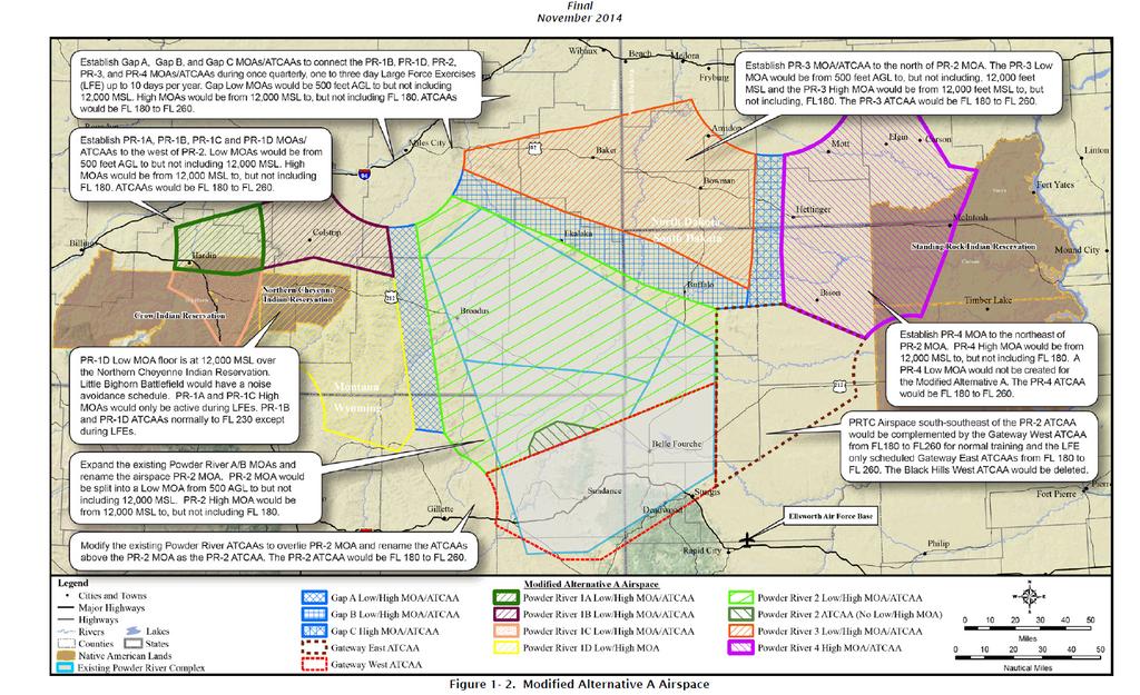
5 applicable mitigation measures in the FEIS and the Programmatic Agreement; (3) develop and implement an adaptive management program to monitor the effectiveness of the mitigation measures and make any necessary adaptations; and (4) request that the FAA take those actions necessary to implement this decision by modifying and establishing the requisite airspace. Subsequent Modifications of the Proposed Action After the completion of the Air Force ROD, the FAA determined that the Fairgrounds Airpark, located in Hardin, MT and included in the proposed PR-1A Low MOA and the proposed PR-1C Low MOA, was closed/deactivated on January 8, 2015 with the simultaneous activation of Big Horn County Airport, MT located approximately three miles northeast of the Fairgrounds Airpark. The FAA subsequently altered the Proposed Action (described below) to remove the Fairgrounds Airpark and include the Big Horn County Airport in the description of the proposed PR-1A Low MOA. The FAA further determined that an exclusion area for the portion of the Northern Cheyenne Reservation extends under the proposed PR-1C MOA and adjusted the Proposed Action to include this exclusion area. Because these are not substantial changes to Modified Alternative A and do not reflect significant new circumstances or information relevant to environmental concerns, they do not require supplementation of the Final EIS. Proposed Action For the purpose of this ROD, the Proposed Action is the modification of the existing Powder River airspace and establishment of new airspace for the PRTC, as described in the Final EIS for Modified Alternative A and with the subsequent modifications described above. 4 The Proposed Action includes the following changes to the existing Powder River airspace (see Figure 1-2 of the Final EIS, 5 reproduced below) for a graphic depiction of the proposed PRTC airspace): Powder River 1A Low MOA, MT (New) Boundaries: Beginning at lat N., long W.; to lat N., long W.; to lat N., long W.; 4 The Air Force initiated pre-coordination with the FAA in 2007, gradually maturing and refining the airspace concept. In 2010, the Air Force submitted the initial PRTC Airspace Proposal for FAA consideration. The proposal was circularized under study number 10-AGL-6NR. The Air Force submitted a revised PRTC Airspace Proposal to the FAA on February 5, 2014 for consideration. The revised airspace proposal was circularized under study number 14-AGL-06NR. Modified Alternative A in the Final EIS includes changes to the Air Force s February 2014 airspace proposal in response to inputs received during the FAA s aeronautical review process for that proposal. 5 The legend in Figure 1-2 of the Final EIS contains an inadvertent error in that it is missing the ATCAA designation for the proposed Powder River 1D ( PR-1D ) area, which is part of the Air Force s airspace proposal for the PRTC. However, the PR-1D ATCAA is included in the Final EIS analysis and tables. FAA Record of Decision 5 Powder River Training Complex
6 to lat N., long W.; to lat N., long W.; clockwise along the Billings VORTAC 68 NM arc; to lat N., long W.; to lat N., long W.; to lat N., long W.; counter clockwise along the Billings VORTAC 38 NM arc; to the point of beginning. Designated Altitudes: 500 feet AGL to, but not including 12,000 feet MSL, excluding the airspace 1,500 feet AGL and below within a 3 NM radius of the Big Horn County Airport, MT. Times of Use: and Monday - Thursday and Friday, by NOTAM 2 hours in advance; other times by NOTAM 4 hours in advance. (Estimate of expected area use is 3-hours per day, approximately 240 days per year.) Controlling Agency: Using Agency: FAA, Salt Lake ARTCC. U.S. Air Force, 28th Bomb Wing, Ellsworth AFB, SD. Powder River 1A High MOA, MT (New) Boundaries: Beginning at lat N., long W.; to lat N., long W.; to lat N., long W.; to lat N., long W.; to lat N., long W.; clockwise along the Billings VORTAC 68 NM arc; to lat N., long W.; to lat N., long W.; to lat N., long W.; counter clockwise along the Billings VORTAC 38 NM arc; to the point of beginning. Designated Altitudes: 12,000 feet MSL to, but not including FL 180. Times of Use: By NOTAM 4 hours in advance. (LFE Only) FAA Record of Decision 6 Powder River Training Complex
7 Controlling Agency: Using Agency: FAA, Salt Lake ARTCC. U.S. Air Force, 28th Bomb Wing, Ellsworth AFB, SD. Power River 1B Low MOA, MT (New) Boundaries: Beginning at lat N., long W.; to lat N., long W.; counter clockwise along the Miles City VOR/DME 25 NM arc; to lat N., long W.; to lat N., long W.; to lat N., long W.; to lat N., long W.; counter clockwise along the Billings VORTAC 68 NM arc; to the point of beginning. Designated Altitudes: 500 feet AGL to, but not including 12,000 feet MSL, excluding the airspace 1,500 feet AGL and below within a 3 NM radius of the Colstrip Airport, MT. Times of Use: and Monday - Thursday and Friday, by NOTAM 2 hours in advance; other times by NOTAM 4 hours in advance. (Estimate of expected area use is 3-hours per day, approximately 240 days per year.) Controlling Agency: Using Agency: FAA, Salt Lake ARTCC. U.S. Air Force, 28th Bomb Wing, Ellsworth AFB, SD. Powder River 1B High MOA, MT (New) Boundaries: Beginning at lat N., long W.; to lat N., long W.; counter clockwise along the Miles City VOR/DME 25 NM arc; to lat N., long W.; to lat N., long W.; to lat N., long W.; to lat N., long W.; counter clockwise along the Billings VORTAC 68 NM arc; FAA Record of Decision 7 Powder River Training Complex
8 to the point of beginning. Designated Altitudes: 12,000 feet MSL to, but not including FL 180. Times of Use: and Monday - Thursday and Friday, by NOTAM 2 hours in advance; other times by NOTAM 4 hours in advance. (Estimate of expected area use is 3-hours per day, approximately 240 days per year.) Controlling Agency: Using Agency: FAA, Salt Lake ARTCC. U.S. Air Force, 28th Bomb Wing, Ellsworth AFB, SD. Powder River 1C Low MOA, MT (New) Boundaries: Beginning at lat N., long W.; to lat N., long W.; to lat N., long W.; clockwise along the Billings VORTAC 68 NM arc; to lat N., long W.; to lat N., long W.; to lat N., long W.; to lat N., long W.; counter clockwise along the Billings VORTAC 38 NM arc; to the point of beginning, excluding the airspace within the Northern Cheyenne Indian Reservation. Designated Altitudes: 500 feet AGL to, but not including 12,000 feet MSL. Times of Use: and Monday - Thursday and Friday, by NOTAM 2 hours in advance; other times by NOTAM 4 hours in advance. (Estimate of expected area use is 3 hours per day, approximately 240 days per year.) Controlling Agency: FAA, Salt Lake ARTCC. FAA Record of Decision 8 Powder River Training Complex
9 Using Agency: U.S. Air Force, 28th Bomb Wing, Ellsworth AFB, SD. Mitigation Specific to Powder River 1C Low MOA, MT: Powder River 1C High MOA, MT (New) The Little Bighorn Battlefield noise avoidance area boundaries are: N W to N W to N W to N W to N W to N W to N W to N W to N W to beginning. Hours: From 1 hour prior, to 1 hour after, NPS Hours of Operation. Altitude: The area bounded above will not be over-flown below 5,000 feet AGL during the hours listed above. Special Events: The area bounded above will also be avoided when special events are coordinated. Supersonic: No supersonic flight within the PR-1C Low MOA. Boundaries: Beginning at lat N., long W.; to lat N., long W.; to lat N., long W.; clockwise along the Billings VORTAC 68 NM arc; to lat N., long W.; to lat N., long W.; to lat N., long W.; to lat N., long W.; counter clockwise along the Billings VORTAC 38 NM arc; to the point of beginning. FAA Record of Decision 9 Powder River Training Complex
10 Designated Altitudes: 12,000 feet MSL to, but not including FL 180. Times of Use: Controlling Agency: Using Agency: By NOTAM 4 hours in advance. (LFE Only) FAA, Salt Lake ARTCC. USAF, 28th Bomb Wing, Ellsworth AFB, SD. Mitigation Specific to Powder River 1C High MOA, Montana: Powder River 1D Low MOA, MT (New) Supersonic: No supersonic flight within the PR-1C High MOA. Boundaries: Beginning at lat N., long W.; to lat N., long W.; to lat N., long W.; to lat N., long W.; to lat N., long W.; to lat N., long W.; counter clockwise along the Sheridan VOR/DME 25 NM arc; to lat N., long W.; counter clockwise along the Billings VORTAC 68 NM arc; to the point of beginning, excluding the airspace within the Northern Cheyenne Indian Reservation. Designated Altitudes: 500 feet AGL to, but not including 12,000 feet MSL, excluding the airspace 1,500 feet AGL and below within a 3 NM radius of the St. Labre Mission Airport, MT. Times of Use: and Monday - Thursday and Friday, by NOTAM 2 hours in advance; other times by NOTAM 4 hours in advance. (Estimate of expected area use is 3-hours per day, approximately 240 days per year.) Controlling Agency: FAA, Salt Lake ARTCC. Using Agency: U.S. Air Force, 28th Bomb Wing, Ellsworth, AFB, SD. FAA Record of Decision 10 Powder River Training Complex
11 Powder River 1D High MOA, MT (New) Boundaries: Beginning at lat N., long W.; to lat N., long W.; to lat N., long W.; to lat N., long W.; to lat N., long W.; to lat N., long W.; counter clockwise along the Sheridan VOR/DME 25 NM arc; to lat N., long W.; counter clockwise along the Billings VORTAC 68 NM arc; to the point of beginning. Designated Altitudes: 12,000 feet MSL to, but not including FL 180. Times of Use: and Monday - Thursday and Friday, by NOTAM 2 hours in advance; other times by NOTAM 4 hours in advance. (Estimate of expected area of use is 3-hours per day, 240 days per year) Controlling Agency: Using Agency: FAA, Salt Lake ARTCC. U.S. Air Force, 28th Bomb Wing, Ellsworth, AFB, SD. Powder River 2 Low MOA, MT (New) Boundaries: Beginning at lat N., Long W.; counter clockwise along the Miles City VOR/DME 25 NM arc; to lat N., long W.; to lat N., long W.; to lat N., long W.; to lat N., long W.; to lat N., long W.; to lat N., long W.; to lat N., long W.; to lat N., long W.; FAA Record of Decision 11 Powder River Training Complex
12 to lat N., long W.; to lat N., long W.; to lat N., long W.; counter clockwise along the Gillette VOR/DME 20 NM arc; to lat N., long W.; to lat N., long W.; to the point of beginning. Designated Altitudes: 500 feet AGL to, but not including 12,000 feet MSL, excluding the airspace 1,500 feet AGL and below within a 3 NM radius of Broadus Airport, MT; Ekalaka Airport, MT; and Harding County Airport, SD. Times of Use: and Monday - Thursday and Friday, by NOTAM 2 hours in advance; other times by NOTAM 4 hours in advance. (Estimate of expected area use is 6-hours per day, approximately 240 days per year.) Controlling Agency: Using Agency: FAA, Denver ARTCC. U.S. Air Force, 28th Bomb Wing, Ellsworth AFB, SD. Powder River 2 High MOA, MT (New) Boundaries: Beginning at lat N., long W.; counter clockwise along the Miles City VOR/DME 25 NM arc; to lat N., long W.; to lat N., long W.; to lat N., long W.; to lat N., long W.; to lat N., long W.; to lat N., long W.; to lat N., long W.; to lat N., long W.; to lat N., long W.; to lat N., long W.; to lat N., long W.; FAA Record of Decision 12 Powder River Training Complex
13 counter clockwise along the Gillette VOR/DME 20 NM arc; to lat N., long W.; to lat N., long W.; to the point of beginning. Designated Altitudes: 12,000 feet MSL to, but not including FL 180. Times of Use: and Monday - Thursday and Friday, by NOTAM 2 hours in advance; other times by NOTAM 4 hours in advance. (Estimate of expected area use is 6-hours per day, approximately 240 days per year.) Controlling Agency: Using Agency: FAA, Denver ARTCC. U.S. Air Force, 28th Bomb Wing, Ellsworth AFB, SD. Powder River 3 Low MOA, ND (New) Boundaries: Beginning at lat N., long W.; to lat N., long W.; to lat N., long W.; to lat N., long W.; to lat N., long W.; counter clockwise along the Dickinson VORTAC 30 NM arc; to lat N., long W.; to lat N., long W.; to lat N., long W.; to lat N., long W.; to lat N., long W.; to lat N., long W.; counter clockwise along the Miles City VOR/DME 25 NM arc; to the point of beginning. Designated Altitudes: 500 feet AGL to, but not including 12,000 feet MSL, excluding the airspace 2,000 feet AGL and below within a 3 NM radius of Baker Municipal Airport, MT, and Bowman Municipal Airport, ND. FAA Record of Decision 13 Powder River Training Complex
14 Times of Use: and Monday - Thursday and Friday, by NOTAM 2 hours in advance; other times by NOTAM 4 hours in advance. (Estimate of expected area use is 3-hours per day, approximately 240 days per year.) Controlling Agency: Using Agency: FAA, Salt Lake ARTCC. U.S. Air Force, 28th Bomb Wing, Ellsworth AFB, SD. Powder River 3 High MOA, ND (New) Boundaries: Beginning at lat N., long W.; to lat N., long W.; to lat N., long W.; to lat N., long W.; to lat N., long W.; counter clockwise along the Dickinson VORTAC 30 NM arc; to lat N., long W.; to lat N., long W.; to lat N., long W.; to lat N., long W.; to lat N., long W.; to lat N., long W.; counter clockwise along the Miles City VOR/DME 25 NM arc; to the point of beginning. Designated Altitudes: 12,000 feet MSL to, but not including FL 180. Times of Use: and Monday - Thursday and Friday, by NOTAM 2 hours in advance; other times by NOTAM 4 hours in advance. (Estimate of expected area use is 3-hours per day, 240 days per year.) Controlling Agency: FAA, Minneapolis ARTCC. FAA Record of Decision 14 Powder River Training Complex
15 Using Agency: U.S. Air Force, 28th Bomb Wing, Ellsworth AFB, SD. Powder River 4 High MOA, ND (New) Boundaries: Beginning at lat N., long W.; counter clockwise along the Dickinson VORTAC 30 NM arc; to lat N., long W.; to lat N., long W.; to lat N., long W.; to lat N., long W.; to lat N., long W.; to lat N., long W.; to lat N., long W.; to lat N., long W.; counter clockwise along the Dupree VORTAC 20 NM arc; to lat N., long W.; to lat N., long W.; to lat N., long W.; to the point of beginning. Designated Altitudes: 12,000 feet MSL to, but not including FL 180. Times of Use: and Monday - Thursday and Friday, by NOTAM 2 hours in advance; other times by NOTAM 4 hours in advance. (Estimate of expected area use is 3-hours per day, approximately 240 days per year.) Controlling Agency: Using Agency: FAA, Minneapolis ARTCC. U.S. Air Force, 28th Bomb Wing, Ellsworth AFB, SD. Gap A Low MOA, MT (New) Boundaries: Beginning at lat N., long W.; counter clockwise along the Miles City VOR/DME 25 NM arc; to lat N., long W.; FAA Record of Decision 15 Powder River Training Complex
16 to lat N., long W.; to lat N., long W.; to the point of beginning. Designated Altitudes: 500 feet AGL to, but not including 12,000 feet MSL. Times of Use: Controlling Agency: Using Agency: By NOTAM 4 hours in advance. (LFE Only) FAA, Denver ARTCC. U.S. Air Force, 28th Bomb Wing, Ellsworth AFB, SD. Gap A High MOA, MT (New) Boundaries: Beginning at lat N., long W.; counter clockwise along the Miles City VOR/DME 25 NM arc; to lat N., long W.; to lat N., long W.; to lat N., long W.; to the point of beginning. Designated Altitudes: 12,000 feet AGL to, but not including FL 180. Times of Use: Controlling Agency: Using Agency: By NOTAM 4 hours in advance. (LFE Only) FAA, Denver ARTCC. U.S. Air Force, 28th Bomb Wing, Ellsworth AFB, SD. Gap B Low MOA, MT (New) Boundaries: Beginning at lat N., long W.; counter clockwise along the Miles City VOR/DME 25 NM arc; to lat N., long W.; to lat N., long W.; to lat N., long W.; to lat N., long W.; FAA Record of Decision 16 Powder River Training Complex
17 to lat N., long W.; to lat N., long W.; to lat N., long W.; to lat N., long W.; to the point of beginning. Designated Altitudes: 500 feet AGL to, but not including 12,000 feet MSL, excluding the airspace 1,500 feet AGL and below within a 3-NM radius of Ekalaka Airport, MT, and Harding County Airport, SD. Times of Use: Controlling Agency: Using Agency: By NOTAM 4 hours in advance. (LFE Only) FAA, Salt Lake ARTCC. U.S. Air Force, 28th Bomb Wing, Ellsworth AFB, SD. Gap B High MOA, MT (New) Boundaries: Beginning at lat N., long W.; counter clockwise along the Miles City VOR/DME 25 NM arc; to lat N., long W.; to lat N., long W.; to lat N., long W.; to lat N., long W.; to lat N., long W.; to lat N., long W.; to lat N., long W.; to lat N., long W.; to the point of beginning. Designated Altitudes: 12,000 feet MSL to, but not including FL 180. Times of Use: Controlling Agency: Using Agency: By NOTAM 4 hours in advance. (LFE Only) FAA, Salt Lake ARTCC. U.S. Air Force, 28th Bomb Wing, Ellsworth AFB, SD. FAA Record of Decision 17 Powder River Training Complex
18 Gap C High MOA, ND (New) Boundaries: Beginning at lat N., long W.; counter clockwise along the Dickinson VORTAC 30 NM arc; to lat N., long W.; to lat N., long W.; to lat N., long W.; to lat N., long W.; to lat N., long W.; to lat N., long W.; to the point of beginning. Designated Altitudes: 12,000 feet MSL to, but not including FL 180. Times of Use: Controlling Agency: Using Agency: By NOTAM 4 hours in advance. (LFE Only) FAA, Minneapolis ARTCC. U.S. Air Force, 28th Bomb Wing, Ellsworth AFB, SD. Powder River A MOA, Montana Delete Powder River B MOA, Wyoming Delete Air Traffic Assigned Airspace (ATCAA) 6 The PRTC Airspace Proposal 7 also includes ATCAA areas corresponding to the MOA areas. 6 Under FAA Order JO K, a Special Use Airspace ( SUA ) proposal must state whether or not an ATCAA will be requested to support the proposed SUA. If so, the proposal must describe the ATCAA dimensions and times of use. ATCAA information is requested in the proposal solely to assist the FAA in evaluating the overall aeronautical impact of the SUA proposal. Requests to establish an ATCAA are coordinated directly with the Air Traffic Control ( ATC ) facility having jurisdiction over the airspace and are handled separately from the SUA proposal process. See FAA JO , Paragraph d. 7 Appendix A of the Final EIS is titled Aeronautical Proposal and Airspace Operations, but inadvertently contains the FAA Circular instead of the Air Force Aeronautical Proposal. FAA Record of Decision 18 Powder River Training Complex
19 The current Crossbow ATCAA upper altitude would be lowered to FL 310; the Gateway ATCAA would be modified and split into East and West; and the existing Black Hills ATCAA would be deleted. The primary users of the PRTC airspace would be B-1 bombers from Ellsworth AFB and B-52 bombers from Minot AFB. Bombers and tankers from other bases and transient fighters would also use the PRTC airspace. The annual number of training sortie operations in the PRTC airspace under the Proposed Action would be higher than the annual number of sorties in the existing Powder River MOAs and associated ATCAAs due to the increased size and availability of training airspace local to Ellsworth AFB and Minot AFB. (The Proposed Action would increase local Powder River training sorties from 46 percent of B-1 sorties and 31 percent of B- 52 sorties to 85 percent of both B-1 and B-52 sorties.) Training operations in the PRTC airspace would include both day to day operations and infrequent Large Force Exercises ( LFEs ). The PR-1A and PR-1C High MOAs and ATCAAs, the Gap MOAs and ATCAAs, and the Gateway East ATCAA would be used only for LFEs. The rest of the PRTC airspace would be used for day to day operations. Day-to-day training operations in the PRTC airspace would be scheduled an estimated 240 days per year. On average, normal day-to-day operations would involve training aircraft operating in an individual MOA/ATCAA for approximately two hours, with approximately 15 to 20 minutes of training activity below 2,000 feet AGL for those missions that require low-altitude training (see Section of the Final EIS). B-52s would operate primarily within ATCAAs with occasional sorties in the new MOAs. B-1 use would be spread throughout the PRTC airspace. The Air Force would use Low MOAs as early in a training mission as allowed so they could be made available for civil aviation use as soon as possible (see Section of the Final EIS). Approximately 17 percent of the average daily flight hours would be 2,000 feet AGL or below (see Section of the Final EIS). As stated in Table of the Final EIS, the expected daily use of the various PRTC airspace components for day-to-day operations would range from three to seven hours, depending on the component. If the airspaces were scheduled at times other than the published times of use (e.g., because of delays from mechanical, personnel, or weather conditions), this would be announced by NOTAM four hours in advance. LFEs provide mission training in simulated combat engagements and involve approximately 20 aircraft of various types. They would be scheduled once per quarter for up to three days and would not exceed a total of 10 days per year. PRTC airspace would be activated an estimated four hours per LFE day. LFEs would occupy all or substantial portions of the PRTC airspace. During an LFE, the PRTC airspace components could be activated in any number of configurations to accommodate the realistic training. Only during the LFEs, B-1 bombers and transient fighters would conduct realistic training that would involve supersonic flights within the PRTC airspace. Supersonic flights could occur during air combat, air-to-air engagements, defensive maneuvers, and other tactics during an LFE. All B-1 supersonic activities would occur above 20,000 feet MSL; all transient fighter supersonic activity would be above 10,000 feet AGL. B-1s would fly supersonic for about 30 seconds FAA Record of Decision 19 Powder River Training Complex
20 during 60 sorties, or approximately 30 minutes per year, and fighters would engage in an estimated 48 minutes of supersonic flight per year, with an estimated five percent between 10,000 feet AGL and 18,000 feet MSL and 95 percent from 18,000 feet MSL to 26,000 feet MSL. Supersonic activity would generally be experienced toward the center of the LFE airspace over the proposed PR-2, PR-3, and Gap B MOAs and ATCAAs as aircraft use supersonic capabilities in engagements. The Air Force s training in the PRTC airspace would also involve the use of defensive countermeasures (chaff and flares). Defensive countermeasures are used by military aircraft during training in response to simulated threats. Chaff is a self protection device that permits an aircraft threatened by enemy radar directed munitions to distract and/or avoid the threat (see Appendix C). Flares are used in pilot training to develop the near instinctive reactions to a threat that are critical to combat survival (see Appendix D). The FAA s Pilot/Controller Glossary defines chaff as thin, narrow metallic reflectors of various lengths and frequency responses, used to reflect radar energy. These reflectors when dropped from aircraft and allowed to drift downward result in large targets on the aircraft s radar display. Self protection flares are magnesium pellets that, when ignited, burn for 3.5 to five seconds at 2,000 degrees Fahrenheit. The burn temperature is hotter than the exhaust of an aircraft, and therefore attracts and decoys heat seeking weapons targeted on the aircraft (see Appendix D of the Final EIS). The Air Force estimates that a total of approximately 24,508 chaff bundles and 2,450 flares would be deployed annually during training operations in the PRTC airspace. FAA Record of Decision 20 Powder River Training Complex
21
22 Purpose and Need The Air Force s 28th Bomb Wing is based at Ellsworth Air Force Base ( AFB ) in South Dakota. The 28th Bomb Wing, which flies B-1 bombers, currently manages and trains in the Powder River A and B MOAs and associated ATCAAs overlying parts of the states of South Dakota, Wyoming, and Montana. The 5th Bomb Wing, based at Minot AFB in North Dakota, flies B-52 bombers and also trains in the existing Powder River training airspace. As described in Section 1.4 of the Final EIS, the existing airspace does not meet the Air Force s mission training needs for current and projected combat conditions. The purpose of the Proposed Action, as stated in Section 1.4 of the Final EIS, is to provide local airspace that would support primarily Ellsworth and Minot AFBs with the capability to adequately train aircrews and ensure their readiness to succeed and survive in combat while mitigating, to the extent possible, agency, tribal, and public concerns. Alternatives As previously mentioned in the Background section of this ROD, the Final EIS analyzes four alternatives: Modified Alternative A, Modified Alternative B, Modified Alternative C, and the No-Action Alternative. These alternatives are described in detail in Chapter 2.0 of the Final EIS. A summary of Modified Alternative A is presented in the Proposed Action section of this ROD. Modified Alternative B differs from Modified Alternative A in that it does not include the PR-1 MOAs and the Gap A MOAs and it adds a PR 4 Low MOA extending from 500 feet AGL up to, but not including, 12,000 feet MSL. Modified Alternative C differs from Modified Alternative A in that it does not include the PR-4 MOAs and the Gap C MOAs. The general nature and timing of training operations under Modified Alternative B and Modified Alternative C would be similar to those under Modified Alternative A. However, operational differences from Modified Alternative A would include a smaller percentage of B-1 and B-52 training sorties being accomplished locally (65 percent for Modified Alternative B and 70 to 80 percent for Modified Alternative C, compared to 85 percent for Modified Alternative A), and decreased low level training capability under Modified Alternative B that would not meet the Air Force s terrain following training requirements (the land under the PR-4 Low MOA would provide less varied topography than the PR-1 Low MOAs). The Final EIS identifies Modified Alternative A as the Air Force s preferred alternative. As explained in Section of the Final EIS, Modified Alternative A best meets the Air Force s purpose and need by providing combinations of MOA and ATCAA airspaces with the most improved training capability compared to existing conditions. The airspace configurations under Modified Alternatives B and C, while superior to the existing airspace, provide fewer MOA and ATCAA airspaces than the Modified Alternative A, and less airspace for low level training and LFEs. FAA Record of Decision 22 Powder River Training Complex
23 Public, Agency, and Tribal Involvement Public Participation Process The public participation process began with publication of the Air Force s Notice of Intent ( NOI ) to prepare an Environmental Impact Statement. The NOI was published May 29, 2008 in the Federal Register. The NOI listed the locations and times of 15 public scoping meetings: four in South Dakota in June and July 2008, three in Wyoming in June 2008, six in Montana in June and July 2008 and two in North Dakota in July FAA employees attended many of these scoping meetings. Section of the Final EIS details the Draft EIS public comment process. The U.S. Environmental Protection Agency ( EPA ) published a Notice of Availability of the Draft EIS in the Federal Register on August 20, In August 2010, the Air Force sent notices of 19 public hearings to 31 newspapers in Montana, North Dakota, South Dakota, and Wyoming. The Air Force held these public hearings in September and October 2010 in locations centrally located in geographic areas potentially affected by the PRTC proposal (eight in Montana, four each in North Dakota and South Dakota, and three in Wyoming). FAA personnel attended all of these public hearings, which were attended by 489 public and agency attendees and 39 elected officials. The Air Force encouraged public and agency representatives to provide oral and written comments during the public hearings or mail written comments on or before the comment period closing date of November 15, By request, the Air Force reopened and extended the comment period to January 20, 2011, for a total comment period of 100 days. The FAA, as a cooperating agency, assisted the Air Force in responding to comments received during the Draft EIS public comment period. Appendix G of the Final EIS contains the comments on the Draft EIS and the responses to those comments. During the FAA s separate aeronautical review process for the proposed PRTC, the FAA received numerous comments, some of which included environmental aspects. In accordance with established procedures, the FAA forwarded these comments to the Air Force. Appendix H of the Final EIS contains the comments the FAA received during its aeronautical review of the Air Force s February 2014 revised airspace proposal for the PRTC, as well as the Air Force s responses to those comments. On November 28, 2014, EPA published a Notice of Availability of the Final EIS for the PRTC in the Federal Register, with a 30-day review period ending on December 29, During the review period, the Air Force received nine comment letters (three of these letters were also sent to the FAA). One of these letters was from EPA, which stated the results of its review of the Air Force s Final EIS as follows: The FEIS shows the careful consideration of project impacts by the Air Force. The Final EIS is well organized and provides a thoughtful analysis of environmental impacts and consequences. The EPA has no objections to this FAA Record of Decision 23 Powder River Training Complex
24 project moving forward with the environmental protection measures identified in the Final EIS. The remaining letters received after the publication of the FEIS are substantially similar to comments to which the Air Force responded in Appendices G and H of the Final EIS. To assist in public participation and visibility, the Air Force has maintained a public website for the PRTC ( on which the Draft EIS, the FAA s circularization document, the Final EIS, and the Air Force s ROD are posted in addition to other documents. Agency and Tribal Coordination During the review process for the PRTC, the Air Force has had numerous communications with other agencies and Tribal governments (see Section 2.12 and Appendices E and N of the Final EIS). During the scoping process for the Draft EIS, tribal scoping meetings were held at the Crow Agency, MT on June 23, 2008; the Northern Cheyenne Tribal Council Chamber in Lame Deer, MT on June 24, 2008; the Standing Rock Indian Reservation in McLaughlin, SD and Fort Yates, ND on July 11, 2008; and at the Cheyenne River Indian Reservation at Dupree, SD on July 16, The Air Force also met with these tribes several times during the Draft EIS comment period. Formal hearings were held with the Crow Tribe on October 25, 2010; with the Northern Cheyenne Tribe on December 7, 2010; with the Standing Rock Sioux Tribe on September 27, 2010; and with the Cheyenne River Sioux Tribe on December 9, At these hearings, which were in addition to the 19 public hearings described previously, the Air Force provided information comparable to what it provided at the other public hearings held on the Draft EIS. The Air Force also coordinated with other agencies and tribes during the NHPA Section 106 consultation process. In addition to the Crow Tribe, the Northern Cheyenne Tribe, the Cheyenne River Sioux Tribe, and the Standing Rock Sioux Tribe, the consulting parties in that process included the State Historic Preservation Offices ( SHPOs ) in Montana, Wyoming, North Dakota, and South Dakota, and the National Park Service ( NPS ). The process resulted in the development of a Programmatic Agreement ( PA ) that was signed by the Air Force, the Crow Tribe, the SHPOs, the NPS, the Advisory Council on Historic Preservation ( ACHP ), and the FAA (the PA is included in Appendix N of the Final EIS). Among other terms, the PA includes stipulations concerning avoidance, minimization, or mitigation of adverse effects to historic properties, religious ceremonies, and important tribal events under the proposed PRTC airspace. Other agency coordination included the Air Force s consultations with the U.S. Fish and Wildlife Service ( USFWS ) regarding potential effects of the Proposed Action on species protected under the Endangered Species Act. (see Sections and and Appendix E of the Final EIS). These consultations are described in more detail under Fish, Wildlife, and Plants in the Environmental Consequences section below. FAA Record of Decision 24 Powder River Training Complex
25 Mitigation Input from the public, agencies, and tribes during the Air Force NEPA process, the NHPA Section 106 consultation process, and the FAA s aeronautical review process assisted the Air Force and the FAA in identifying measures that would avoid, minimize, or otherwise mitigate potential adverse impacts of the proposed PRTC. Specific mitigation measures that are incorporated into, or otherwise would be implemented as part of, the Proposed Action are identified in the Final EIS (see Section 2.3.1), and the NHPA Section 106 Programmatic Agreement (included in Appendix N of the Final EIS), and have been adopted by the Air Force in its ROD. These mitigation measures include: 1. Dividing the proposed PR-1 MOA into eight MOA segments to better enable arrivals and departures from local airports, allow civil aviation to use parts of the airspace not being used for military training, and allow military use of parts of the airspace while other parts are avoided to reduce potential impacts on the ground (see sections 2.3.1, 2.3.2, and of the Final EIS). 2. Providing reasonable and timely aerial access to underlying private or public use land to accommodate instrument arrivals and departures with minimum delay and for terminal Visual Flight Rules (VFR) and IFR operations (see Sections 2.3.1, and of the Final EIS). 3. Raising the floor of the proposed PR-4 and Gap C MOAs from 500 feet AGL to 12,000 feet MSL by removing the PR-4 and Gap C Low MOAs, thereby supporting general aviation flight operations, avoiding low-altitude overflight of the Standing Rock Sioux and Cheyenne River Sioux Reservations, limiting low-altitude overflight over ranches and communities, and avoiding low-altitude training impacts to the whooping crane in its migration corridor (see sections 2.3.1, , , and and Appendix E of the Final EIS [the average surface elevation under the proposed PR-4 and Gap C MOAs is 2,300 feet MSL, resulting in an average floor of 9,700 feet AGL for those MOAs]). 4. Reducing B-1 flight operations in the proposed PR-1, PR-3, and PR-4 MOAs by 12 percent from that proposed in the Draft EIS (see section of the Final EIS). 5. Limiting all PRTC activity to altitudes at or below 26,000 feet MSL (in the PR-1B and PR-1D ATCAAs, the airspace from 23,000 MSL to 26,000 MSL would be used only for infrequent LFEs) to reduce impacts on aircraft utilizing high-altitude routing (see sections and of the Final EIS). 6. Moving the proposed PRTC airspace boundaries back from airports in Billings and Miles City, MT; Dickinson and Bismarck, ND; and Hulett, Gillette, and Sheridan, WY to facilitate IFR procedures at these airports (see sections and of the Final EIS). FAA Record of Decision 25 Powder River Training Complex
26 7. Adjusting the proposed Gap MOA boundaries to enable navigation by civil aviation, including modifying the proposed Gap B MOA to avoid it extending across the proposed Gap C MOA to deconflict with Victor Route 491 ( V-491 ) when the proposed Gap B MOA is active and the Gap C MOA is not (see sections 2.3.1, , and of the Final EIS). 8. Adjusting proposed airspace boundaries to support navigation (such as the use of the global positioning system) on Victor airways (see sections and of the Final EIS). 9. Adjusting the southwest border of the proposed PR-1B MOA/ATCAA to enable use of Victor Route 247 ( V-147 ), an aircraft flight route between Sheridan, WY and Billings, MT (see sections 2.3.1, and of the Final EIS). 10. Announcing all PRTC training activity via Notices to Airmen (NOTAMs), at least two hours in advance during published times of use, and at least four hours in advance outside of published times of use and for airspace only used during LFEs (see Sections and and Appendix A 8 of the Final EIS). 11. Allowing Air Traffic Control ( ATC ) to vector IFR traffic through Low and High MOAs as soon as training is completed in an airspace segment by notifying ATC when MOA altitude segments are no longer needed for training (see Sections 2.3.1, and of the Final EIS). 12. Facilitating the issuance of a NOTAM when schedule changes require use of proposed PRTC airspace outside of published times of use by informing Air Route Traffic Control Centers ( ARTCCs ) at least four hours in advance (see Sections and of the Final EIS). 13. Ensuring the ability to recall the military aircraft from the low-altitude MOAs by establishing communication procedures that enable controlling agencies to recall the low MOA airspace whenever necessary to allow IFR aircraft access to and from public use airports underlying the MOA (see Sections and of the Final EIS). 14. Ensuring the ability to respond to ATC control instructions by establishing communication procedures that provide for safe de-confliction with emergency flight operations and firefighting operations within the PRTC airspace (see Sections and of the Final EIS). 15. Publishing a notice at least 30 days in advance of LFE s, thereby helping the public, the aviation community, and tribes plan for LFE activation and alerting affected populations 8 See footnote 7 regarding Appendix A of the Final EIS. FAA Record of Decision 26 Powder River Training Complex
Acronyms and Abbreviations
 Acronyms and Abbreviations 28 CES 28th Civil Engineering Squadron 28 BW 28th Bomb Wing 28 BW/PA 28th Bomb Wing/Public Affairs 28 OG 28th Operations Group 28 OSS 28th Operations Support Squadron A3 Training
What Is The Proposed 29Palms Training Land Acquisition and Airspace Establishment Project? Frequently Asked Questions Airspace Related June 2014
 MARINE CORPS / DEPARTMENT OF THE NAVY SUBMIT SPECIAL USE AIRSPACE PROPOSALS TO THE FEDERAL AVIATION ADMINISTRATION TO MEET MARINE EXPEDITIONARY BRIGADE TRAINING REQUIREMENTS 1. Why has the Marine Corps
What Is The 29Palms Training Land Acquisition and Airspace Establishment Project Frequently Asked Questions Airspace Related July 2015
 MARINE CORPS / DEPARTMENT OF THE NAVY SUBMIT SPECIAL USE AIRSPACE PROPOSALS TO THE FEDERAL AVIATION ADMINISTRATION TO MEET MARINE EXPEDITIONARY BRIGADE TRAINING REQUIREMENTS 1. Why has the Marine Corps
Powder River Training Complex Commonly Asked Questions September 15, 2010
 Powder River Training Complex Commonly Asked Questions September 15, 2010 QUESTION: Why is this expansion needed? Answer: Realistic and effective training. Twenty years ago, enemy surface-to-air threats
Proposed Establishment of and Modification to Restricted Areas; Fort Sill, OK
 This document is scheduled to be published in the Federal Register on 10/19/2015 and available online at http://federalregister.gov/a/2015-26499, and on FDsys.gov 4910-13 DEPARTMENT OF TRANSPORTATION Federal
Airspace Establishment Project Frequently Asked Questions Permanent SUA and Environmental Assessment March 2019
 OVERVIEW OF PERMANENT SPECIAL USE AIRSPACE ESTABLISHMENT AND MODIFICATIONS AT MARINE AIR GROUND TASK FORCE TRAINING COMMAND, TWENTYNINE PALMS, CA 1. What is Special Use Airspace (SUA)? Special Use Airspace
Powder River Training Complex Ellsworth Air Force Base, South Dakota Environmental Impact Statement
 Powder River Training Complex Environmental Impact Statement Powder River Training Complex Ellsworth Air Force Base, South Dakota Environmental Impact Statement August 2010 This volume contains the printed
Amendment of Restricted Areas R-2907A and R-2907B, Lake George, FL; and R-2910, Pinecastle, FL
 This document is scheduled to be published in the Federal Register on 07/03/2013 and available online at http://federalregister.gov/a/2013-16054, and on FDsys.gov 4910-13 DEPARTMENT OF TRANSPORTATION Federal
Civil/Military Coordination Workshop Havana, Cuba April 2015
 Civil/Military Coordination Workshop Havana, Cuba 13-17 April 2015 Civil/Military Coordination in the United States based on Appendix A of ICAO Circular 330 Dave Edwards, U.S. Coast Guard Chairman, ICAO/International
Amendment of Restricted Areas R-3004A and R-3004B and Establishment of R-3004C;
 This document is scheduled to be published in the Federal Register on 09/25/2017 and available online at https://federalregister.gov/d/2017-20435, and on FDsys.gov 4910-13 DEPARTMENT OF TRANSPORTATION
Powder River Training Complex Special Use Airspace General & Business Aviation Survey
 Powder River Training Complex Special Use Airspace General & Business Aviation Survey February 2018 Survey and Report Completed By Aircraft Owners and Pilots Association National Business Aviation Association
4.6 AIRSPACE. Approach to Analysis
 4.6 AIRSPACE Section 4.6 describes the impacts that could potentially occur to the existing airspace environment from the proposed action. Potential impacts would stem from the establishment of new Special
Establish the Delta Military Operations Area Environmental Assessment
 Establish the Delta Military Operations Area Environmental Assessment January 2010 Acronyms and Abbreviations degree F degree Fahrenheit µg/m 3 micrograms per cubic meter 11 AF 11 th Air Force 3 WG 3 rd
DRAFT ENVIRONMENTAL ASSESSMENT FOR THE CREATION OF RESTRICTED AREA (RA) R-5601G AND R-5601H FORT SILL, OKLAHOMA
 R-5601G AND R-5601H FORT SILL, OKLAHOMA") DRAFT ENVIRONMENTAL ASSESSMENT FOR THE CREATION OF RESTRICTED AREA (RA) R-5601G AND R-5601H FORT SILL, OKLAHOMA Prepared by: Leidos Engineering, LLC Prepared for: U.S. Army Corps of Engineers, Tulsa District
DRAFT ENVIRONMENTAL ASSESSMENT FOR THE CREATION OF RESTRICTED AREA (RA) R-5601G AND R-5601H FORT SILL, OKLAHOMA Prepared by: Leidos Engineering, LLC Prepared for: U.S. Army Corps of Engineers, Tulsa District
FREQUENTLY ASKED QUESTIONS. Modification of the Cheyenne Low and High military operations areas. in eastern Colorado and western Kansas
 FREQUENTLY ASKED QUESTIONS Modification of the Cheyenne Low and High military operations areas in eastern Colorado and western Kansas NATIONAL ENVIRONMENTAL POLICY ACT QUESTIONS Q: What is an environmental
Appendix K: MSP Class B Airspace
 Appendix K: MSP Class B Airspace K All of the open sky covering the United States, from less than an inch off the ground all the way to outer space, is part of America s airspace. This airspace resource
APPENDIX F AIRSPACE INFORMATION
 APPENDIX F AIRSPACE INFORMATION Airspace Use DEFINITION OF AIRSPACE Airspace, or that space which lies above a nation and comes under its jurisdiction, is generally viewed as being unlimited. However,
NAVIGATION: CHARTS, PUBLICATIONS, FLIGHT COMPUTERS (chapters 7 & 8)
") NAVIGATION: CHARTS, PUBLICATIONS, FLIGHT COMPUTERS (chapters 7 & 8) LONGITUDE AND LATITUDE 1. The location of an airport can be determined by the intersection of lines of latitude and longitude. a. Lines
NAVIGATION: CHARTS, PUBLICATIONS, FLIGHT COMPUTERS (chapters 7 & 8) LONGITUDE AND LATITUDE 1. The location of an airport can be determined by the intersection of lines of latitude and longitude. a. Lines
Modification of VOR Federal Airway V-170 in the Vicinity of Devils Lake, ND
 This document is scheduled to be published in the Federal Register on 01/09/2013 and available online at http://federalregister.gov/a/2013-00288, and on FDsys.gov 4910-13 DEPARTMENT OF TRANSPORTATION Federal
FINAL SUPPLEMENTAL ENVIRONMENTAL ASSESSMENT (SEA) FOR MODIFICATION OF AIRSPACE UNITS R-3008A/B/C FROM VISUAL FLIGHT RULES (VFR) TO VFR-INSTRUMENT
 FOR MODIFICATION OF AIRSPACE UNITS R-3008A/B/C FROM VISUAL FLIGHT RULES (VFR) TO VFR-INSTRUMENT") FINAL SUPPLEMENTAL ENVIRONMENTAL ASSESSMENT (SEA) FOR MODIFICATION OF AIRSPACE UNITS R-3008A/B/C FROM VISUAL FLIGHT RULES (VFR) TO VFR-INSTRUMENT FLIGHT RULES (IFR) AT MOODY AIR FORCE BASE, GEORGIA FINAL
FINAL SUPPLEMENTAL ENVIRONMENTAL ASSESSMENT (SEA) FOR MODIFICATION OF AIRSPACE UNITS R-3008A/B/C FROM VISUAL FLIGHT RULES (VFR) TO VFR-INSTRUMENT FLIGHT RULES (IFR) AT MOODY AIR FORCE BASE, GEORGIA FINAL
R-2515 R-2508 COMPLEX
 R-2515 R-2508 COMPLEX Edwards AFB PPR Briefing Edwards AFB and Edwards Class D Surface Area lie within Restricted Area 2515: R-2515 and Edwards Class D Surface Area contain many flight hazards for aircrews
April 5, Dear Mr. Ready,
 50 F St. NW, Suite 750 Washington, D.C. 20001 T. 202-737-7950 F. 202-273-7951 www.aopa.org Mr. Kenneth Ready U.S. Department of Transportation Docket Operations 1200 New Jersey Avenue SE. West Building
Windmills & Airspace Can We Work Together?
 May 29, 2008 Windmills & Airspace Can We Work Together? J. Randolph Babbitt C O N F I D E N T I A L www.oliverwyman.com Windmills & Airspace Overview of Airspace Issues For Wind Turbine Sites The FAA s
Class B Airspace. Description
 Class B Airspace Ref. AIM 3-2-3 and FAR 91.131 Surrounds certain large airports Within each Class B airspace area, there are multiple segments with different ceiling/floor altitudes. Example: 70/30 = ceiling
June 2009 BOI DOC 3-1
 Draft Environmental Assessment for Proposed Airspace Changes for Paradise East and Paradise West Military Operations Areas (MOAs) at Mountain Home Air Force Base (MHAFB) Idaho June 2009 BOI070850106.DOC
FLASHCARDS AIRSPACE. Courtesy of the Air Safety Institute, a Division of the AOPA Foundation, and made possible by AOPA Holdings Company.
 AIRSPACE FLASHCARDS Courtesy of the Air Safety Institute, a Division of the AOPA Foundation, and made possible by AOPA Holdings Company. The Air Safety Institute is dedicated to making flying easier and
R-2508 COMPLEX R-2515 SFC TO UNLIMITED
 R-2508 COMPLEX R-2515 SFC TO UNLIMITED R-2515 Info available online @... http://www.edwards.af.mil/home/r-2515-airspace R-2515 Airspace Brief EAFBI 13-100 PPR Requests SPORT Pre-Brief Sheet EAFB Wx R-2508
** DETERMINATION OF NO HAZARD TO AIR NAVIGATION **
 Mail Processing Center Federal Aviation Administration Southwest Regional Office Obstruction Evaluation Group 2601 Meacham Boulevard Fort Worth, TX 76137 Issued Date: 05/16/2011 Aeronautical Study No.
FUTENMA REPLACEMENT FACILITY BILATERAL EXPERTS STUDY GROUP REPORT. August 31, 2010
 FUTENMA REPLACEMENT FACILITY BILATERAL EXPERTS STUDY GROUP REPORT August 31, 2010 MANDATE AND SCOPE OF WORK: In order to achieve the earliest possible relocation of Marine Corps Air Station Futenma, the
Chapter 6. Nonradar. Section 1. General DISTANCE
 12/10/15 JO 7110.65W Chapter 6. Nonradar Section 1. General 6 1 1. DISTANCE Use mileage based (DME and/or ATD) procedures and minima only when direct pilot/controller communications are maintained. FIG
APPENDIX I AIRSPACE TECHNICAL MEMO
 APPENDIX I AIRSPACE TECHNICAL MEMO Table of Contents 1.0 INTRODUCTION... 1 1.1 AIRSPACE REGULATORY FRAMEWORK... 7 1.2 RESOURCE DEFINITION... 7 1.3 DESCRIPTION OF PROPOSED SPECIAL USE AIRSPACE AND TRAINING
4.2 AIRSPACE. 4.2 Airspace. Supplemental Draft Environmental Impact Statement August 2008 Military Training Activities at Mākua Military Reservation
 4.2 AIRSPACE 4.2.1 Impact Methodology Impacts on airspace use were assessed by evaluating the potential effects of the proposed training activities on the principal attributes of airspace use, as described
Appendix B Ultimate Airport Capacity and Delay Simulation Modeling Analysis
 Appendix B ULTIMATE AIRPORT CAPACITY & DELAY SIMULATION MODELING ANALYSIS B TABLE OF CONTENTS EXHIBITS TABLES B.1 Introduction... 1 B.2 Simulation Modeling Assumption and Methodology... 4 B.2.1 Runway
The following criteria shall be applied within the boundaries of the AO District:
 Sec. 419 (a) Purpose AIRPORT OVERLAY DISTRICT (AO) The purpose of the Airport Overlay District is to regulate and restrict the height of structures, objects, or natural growth, regulate the locations of
SUMMARY: This action establishes Class E airspace at Parkston, SD. Controlled airspace
 This document is scheduled to be published in the Federal Register on 07/12/2013 and available online at http://federalregister.gov/a/2013-16436, and on FDsys.gov [4910-13] DEPARTMENT OF TRANSPORTATION
The NOTAM described will replace previously issued FDC NOTAMs 6/2550 and 7/7778 for the DC ADIZ/FRZ.
 This advisory covers published NOTAMs 7/0206 for the DC ADIZ, 7/0211 for the DC FRZ and FDC 7/0204 for the outer speed restriction. WARNING This document only contains an overview of the new rules for
SUMMARY: This action amends Class B airspace at the Louis Armstrong New Orleans
 This document is scheduled to be published in the Federal Register on 07/20/2015 and available online at http://federalregister.gov/a/2015-17709, and on FDsys.gov 4910-13 DEPARTMENT OF TRANSPORTATION Federal
SUMMARY: This action proposes to amend Class E surface area airspace and Class E
 This document is scheduled to be published in the Federal Register on 02/21/2018 and available online at https://federalregister.gov/d/2018-03411, and on FDsys.gov [4910-13] DEPARTMENT OF TRANSPORTATION
[Docket No. FAA ; Airspace Docket No. 13-ASW-2] Proposed Amendment of Class E Airspace; Fort Polk, LA
![[Docket No. FAA ; Airspace Docket No. 13-ASW-2] Proposed Amendment of Class E Airspace; Fort Polk, LA](/thumbs/95/125852980.jpg "[Docket No. FAA ; Airspace Docket No. 13-ASW-2] Proposed Amendment of Class E Airspace; Fort Polk, LA") This document is scheduled to be published in the Federal Register on 04/30/2013 and available online at http://federalregister.gov/a/2013-10169, and on FDsys.gov [4901-13] DEPARTMENT OF TRANSPORTATION
This document is scheduled to be published in the Federal Register on 04/30/2013 and available online at http://federalregister.gov/a/2013-10169, and on FDsys.gov [4901-13] DEPARTMENT OF TRANSPORTATION
Contents. Subpart A General 91.1 Purpose... 7
 Contents Rule objective... 3 Extent of consultation... 3 Summary of comments... 4 Examination of comments... 6 Insertion of Amendments... 6 Effective date of rule... 6 Availability of rules... 6 Part 91
HOUSTON AIR ROUTE TRAFFIC CONTROL CENTER VATSIM United States Division. Letter of Agreement. Revised: July 25, 2004 Effective: July 25, 2004
 HOUSTON AIR ROUTE TRAFFIC CONTROL CENTER VATSIM United States Division Letter of Agreement Revised: July 25, 2004 Effective: July 25, 2004 Purpose Scope This Letter of Agreement (LOA) establishes operating
SUMMARY: This action amends Class C airspace at El Paso International Airport, El Paso,
 This document is scheduled to be published in the Federal Register on 12/01/2016 and available online at https://federalregister.gov/d/2016-28726, and on FDsys.gov 4910-13 DEPARTMENT OF TRANSPORTATION
SUMMARY: This action proposes to amend Class D airspace, and Class E airspace
 This document is scheduled to be published in the Federal Register on 01/23/2018 and available online at https://federalregister.gov/d/2018-01026, and on FDsys.gov [4910-13] DEPARTMENT OF TRANSPORTATION
[Docket No. FAA ; Airspace Docket No. 15-ASO-11] Establishment of Class D and Class E Airspace, and Amendment of Class
![[Docket No. FAA ; Airspace Docket No. 15-ASO-11] Establishment of Class D and Class E Airspace, and Amendment of Class](/thumbs/95/124343511.jpg "[Docket No. FAA ; Airspace Docket No. 15-ASO-11] Establishment of Class D and Class E Airspace, and Amendment of Class") This document is scheduled to be published in the Federal Register on 04/06/2016 and available online at http://federalregister.gov/a/2016-07782, and on FDsys.gov [4910-13] DEPARTMENT OF TRANSPORTATION
This document is scheduled to be published in the Federal Register on 04/06/2016 and available online at http://federalregister.gov/a/2016-07782, and on FDsys.gov [4910-13] DEPARTMENT OF TRANSPORTATION
** DETERMINATION OF NO HAZARD TO AIR NAVIGATION **
 Mail Processing Center Federal Aviation Administration Southwest Regional Office Obstruction Evaluation Group 2601 Meacham Boulevard Fort Worth, TX 76137 Issued Date: 01/04/2012 Aeronautical Study No.
Proposed Amendment of Class D and Class E Airspace for the following Oklahoma
 This document is scheduled to be published in the Federal Register on 03/11/2016 and available online at http://federalregister.gov/a/2016-05177, and on FDsys.gov [4910-13] DEPARTMENT OF TRANSPORTATION
Daisy Dean Trail 628/619 ATV Trail Construction
 Background and Purpose and Need The Daisy Dean ATV Trail Construction Project is located in the Little Belt Mountains, Musselshell Ranger District, Lewis and Clark National Forest approximately 32 miles
SUMMARY: This action modifies Class E surface airspace and Class E airspace extending
 This document is scheduled to be published in the Federal Register on 10/29/2018 and available online at https://federalregister.gov/d/2018-23478, and on govinfo.gov [4910-13] DEPARTMENT OF TRANSPORTATION
Intro to Small Unmanned Aircraft Systems & Recreational Drones
 Intro to Small Unmanned Aircraft Systems & Recreational Drones Controlled Airspace Controlled Airspace has defined dimensions within which Air Traffic Control (ATC) services are provided. The level of
Department of Defense DIRECTIVE
 Department of Defense DIRECTIVE NUMBER 5030.61 May 24, 2013 Incorporating Change 2, August 24, 2017 USD(AT&L) SUBJECT: DoD Airworthiness Policy References: See Enclosure 1 1. PURPOSE. This directive establishes
FAA FORM UAS COA Attachment FAA
 Page 1 of 6 DEPARTMENT OF TRANSPORTATION FEDERAL AVIATION ADMINISTRATION CERTIFICATE OF WAIVER OR AUTHORIZATION ISSUED TO Xcam Aerials, Inc. 10197 SE 144th Place Summerfield, FL 34491 This certificate
Proposed Amendment of Class E Airspace for the following South Dakota Towns: Belle Fourche, SD; Madison, SD; Mobrigde, SD; and Vermillion, SD
 This document is scheduled to be published in the Federal Register on 02/17/2016 and available online at http://federalregister.gov/a/2016-03066, and on FDsys.gov [04910-13] DEPARTMENT OF TRANSPORTATION
Letter of Agreement. Between Jacksonville ARTCC and Virtual United States Navy Effective Date: Sept 1, 2008
 Letter of Agreement Between Jacksonville ARTCC and Virtual United States Navy Effective Date: Sept 1, 2008 Purpose: This Letter of Agreement (LOA) outlines standard operating policies and procedures to
Amendment of Class E Airspace for the following Missouri towns: Chillicothe, MO; Cuba, MO; Farmington, MO; Lamar, MO; Mountain View, MO; Nevada,
 This document is scheduled to be published in the Federal Register on 10/19/2015 and available online at http://federalregister.gov/a/2015-26273, and on FDsys.gov [4910-13] DEPARTMENT OF TRANSPORTATION
Washington Dulles International Airport (IAD) Aircraft Noise Contour Map Update
 Aircraft Noise Contour Map Update") Washington Dulles International Airport (IAD) Aircraft Noise Contour Map Update Ultimate ASV, Runway Use and Flight Tracks 4th Working Group Briefing 8/13/18 Meeting Purpose Discuss Public Workshop input
Washington Dulles International Airport (IAD) Aircraft Noise Contour Map Update Ultimate ASV, Runway Use and Flight Tracks 4th Working Group Briefing 8/13/18 Meeting Purpose Discuss Public Workshop input
Pope Field, NC MID-AIR COLLISION AVOIDANCE
 Pope Field, NC MID-AIR COLLISION AVOIDANCE 2017 43 rd Air Mobility Operations Group Flight Safety, Pope Field, NC Tel: (910)394-8383/ 8389 Fax: (910)394-8098 E-mail:43AMOGW.SE1@US.AF.MIL The potential
AVIATION PLANNING AND DEVELOPMENT Oakland International Airport 530 Water Street Oakland, CA 94607
 AVIATION PLANNING AND DEVELOPMENT Oakland International Airport 530 Water Street When Do I Need to File an FAA Form 7460-1? Objects Affecting Navigable Airspace (14CFR77) June 2013 Background The Federal
Public Comment on Condor MOA Proposal
 Public Comment on Condor MOA Proposal Michael Wells, Lt. Colonel (retired) P.O. Box 274 Wilton, ME 04294 20 November, 2009 1. As a retired Air Force Lt. Colonel, squadron commander, F-15 Instructor Pilot,
Environmental Assessment for Lowering Base Altitude of Military Operations Areas. Vance Air Force Base
 Environmental Assessment for Lowering Base Altitude of Military Operations Areas Vance Air Force Base United States Air Force Air Education and Training Command 71st Flying Training Wing Report Documentation
SUMMARY: This action amends Class D airspace at Wichita, McConnell AFB, KS. The
 This document is scheduled to be published in the Federal Register on 09/23/2014 and available online at http://federalregister.gov/a/2014-22508, and on FDsys.gov [4910-14] DEPARTMENT OF TRANSPORTATION
Airspace. Chapter 14. Gold Seal Online Ground School. Introduction
 Gold Seal Online Ground School www.onlinegroundschool.com Chapter 14 Airspace Introduction The two categories of airspace are: regulatory and nonregulatory. Within these two categories there are four types:
** DETERMINATION OF NO HAZARD TO AIR NAVIGATION **
 Federal Aviation Administration Air Traffic Airspace Branch, ASW-520 2601 Meacham Blvd. Fort Worth, TX 76137-0520 Aeronautical Study No. 2010-WTE-13969-OE Issued Date: 09/30/2010 Morgan Johnston University
CHAPTER 1: INTRODUCTION
 CHAPTER 1: INTRODUCTION Purpose and Scope The information presented in this report represents the study findings for the 2016 Ronan Airport Master Plan prepared for the City of Ronan and Lake County, the
The purpose of this Demand/Capacity. The airfield configuration for SPG. Methods for determining airport AIRPORT DEMAND CAPACITY. Runway Configuration
 Chapter 4 Page 65 AIRPORT DEMAND CAPACITY The purpose of this Demand/Capacity Analysis is to examine the capability of the Albert Whitted Airport (SPG) to meet the needs of its users. In doing so, this
MONTEREY REGIONAL AIRPORT MASTER PLAN TOPICAL QUESTIONS FROM THE PLANNING ADVISORY COMMITTEE AND TOPICAL RESPONSES
 MONTEREY REGIONAL AIRPORT MASTER PLAN TOPICAL QUESTIONS FROM THE PLANNING ADVISORY COMMITTEE AND TOPICAL RESPONSES Recurring topics emerged in some of the comments and questions raised by members of the
Summary of Public Submissions Received on
 Summary of Public Submissions Received on NPRM 15-01 Omnibus 2014 Prepared by DENISE RATIETA and PAUL ELTON 17 August 2015 Table of Contents General... 1 Summary of Submissions... 1 Definition of controlled
Effective Altitude. R-3103 To 30,000 (To 9,144 meters) Source: NACO 2002 Notes: 1 By NOTAM issued 12 hours in advance
 Source: NACO 2002 Notes: 1 By NOTAM issued 12 hours in advance") 8.4 AIRSPACE USE 8.4.1 Affected Environment The affected airspace environment is described below in terms of its principal attributes, namely controlled and uncontrolled airspace, special use airspace,
8.4 AIRSPACE USE 8.4.1 Affected Environment The affected airspace environment is described below in terms of its principal attributes, namely controlled and uncontrolled airspace, special use airspace,
Amendment of Class E Airspace for the following South Dakota Towns; Belle Fourche,
 This document is scheduled to be published in the Federal Register on 06/01/2016 and available online at http://federalregister.gov/a/2016-12638, and on FDsys.gov [4910-13] DEPARTMENT OF TRANSPORTATION
CHAPTER 6 FLIGHT FOLLOWING
 CHAPTER 6 FLIGHT FOLLOWING The procedures in this chapter for flight following and airspace management are for use in and around cantonment areas, training areas, and ranges. However, this does not preclude
Airports and UAS: Managing UAS Operations in the Airport Vicinity
 ACRP Problem Statement 17-10-09 Recommended Allocation: $350,000 Airports and UAS: Managing UAS Operations in the Airport Vicinity ACRP Staff Comments This is one of four UAS-themed problem statements
[Docket No. FAA ; Airspace Docket No. 14-ASO-4] SUMMARY: This action proposes to amend Class E Airspace at Newnan, GA,
![[Docket No. FAA ; Airspace Docket No. 14-ASO-4] SUMMARY: This action proposes to amend Class E Airspace at Newnan, GA,](/thumbs/96/128013796.jpg "[Docket No. FAA ; Airspace Docket No. 14-ASO-4] SUMMARY: This action proposes to amend Class E Airspace at Newnan, GA,") This document is scheduled to be published in the Federal Register on 03/18/2014 and available online at http://federalregister.gov/a/2014-05888, and on FDsys.gov [4910-13] DEPARTMENT OF TRANSPORTATION
This document is scheduled to be published in the Federal Register on 03/18/2014 and available online at http://federalregister.gov/a/2014-05888, and on FDsys.gov [4910-13] DEPARTMENT OF TRANSPORTATION
AIRPORT LAND USE COMPATILIBILTY AIRPORT LAND USE COMPATIBILIITY
 CHAPTER 7 AIRPORT LAND USE COMPATILIBILTY CHAPTER 7 AIRPORT LAND USE COMPATIBILIITY 7.0 INTRODUCTION On airport aviation related development is typically compatible with aircraft operations. On airport
FLIGHT ADVISORY WASHINGTON D.C. SPECIAL FLIGHT RULES AREA LEESBURG MANUVERING AREA
 FLIGHT ADVISORY WASHINGTON D.C. SPECIAL FLIGHT RULES AREA LEESBURG MANUVERING AREA EFFECTIVE October 11, 201609 0400 This Notice does not supersede restrictions pertaining to the use of airspace contained
COMPLIANCE WITH THIS PUBLICATION IS MANDATORY
 BY ORDER OF THE COMMANDER 30TH SPACE WING 30TH SPACE WING INSTRUCTION 13-205 2 OCTOBER 2006 Certified Current 18 September 2017 Space Missile Command and Control RESTRICTED AREA/DANGER ZONE ENTRY ACCESSIBILITY:
Municipal Drone Operations Ben Roper City of College Station
 Municipal Drone Operations Ben Roper City of College Station Unmanned Aerial System (UAS) aka Drone You are establishing an aviation unit for your entity What could possible go wrong? https://youtu.be/aolm1aqkews
[Docket No. FAA ; Airspace Docket No. 18-ASO-13] Amendment of Class D Airspace and Establishment of Class E Airspace;
![[Docket No. FAA ; Airspace Docket No. 18-ASO-13] Amendment of Class D Airspace and Establishment of Class E Airspace;](/thumbs/90/103721008.jpg "[Docket No. FAA ; Airspace Docket No. 18-ASO-13] Amendment of Class D Airspace and Establishment of Class E Airspace;") This document is scheduled to be published in the Federal Register on 11/21/2018 and available online at https://federalregister.gov/d/2018-25328, and on govinfo.gov [4910-13] DEPARTMENT OF TRANSPORTATION
This document is scheduled to be published in the Federal Register on 11/21/2018 and available online at https://federalregister.gov/d/2018-25328, and on govinfo.gov [4910-13] DEPARTMENT OF TRANSPORTATION
EXPLANATION OF TPP TERMS AND SYMBOLS
 U.S. TERMINAL PROCEDURES PUBLICATION 52 EXPLANATION OF TPP TERMS AND SYMBOLS The discussions and examples in this section will be based primarily on the IFR (Instrument Flight Rule) Terminal Procedures
USE OF RADAR IN THE APPROACH CONTROL SERVICE
 USE OF RADAR IN THE APPROACH CONTROL SERVICE 1. Introduction The indications presented on the ATS surveillance system named radar may be used to perform the aerodrome, approach and en-route control service:
UNITED STATES OF AMERICA FEDERAL AVIATION ADMINISTRATION WASHINGTON D.C. GRANT OF EXEMPTION
 In the matter of the petition of the DEPARTMENT OF DEFENSE UNITED STATES OF AMERICA FEDERAL AVIATION ADMINISTRATION WASHINGTON D.C. Exemption No. 5100B For an exemption from the provisions 25863 Of sections
Airports and UAS: Integrating UAS into Airport Infrastructure and Planning
 ACRP Problem Statement 17-03-09 Recommended Allocation: $500,000 Airports and UAS: Integrating UAS into Airport Infrastructure and Planning ACRP Staff Comments This is one of four UAS-themed problem statements
Agenda: SASP SAC Meeting 3
 Agenda: SASP SAC Meeting 3 Date: 04/12/18 Public Involvement Plan Update Defining the System Recommended Classifications Discussion Break Review current system Outreach what we heard Proposed changes Classification
PUBLIC INFORMATION WORKSHOP #4 / PUBLIC HEARING November 8 / 9, 2006
 PUBLIC INFORMATION WORKSHOP #4 / PUBLIC HEARING November 8 / 9, 2006 A Noise Compatibility Study, prepared under Part 150 of the Federal Aviation Regulations (FAR), is a voluntary program aimed at balancing
ORDINANCE NO. _2013-
 ORDINANCE NO. _2013- AN ORDINANCE OF THE TOWNSHIP OF CONEWAGO, DAUPHIN COUNTY, PENNSYLVANIA, PROVIDING FOR AIRPORT ZONING REGULATIONS WITHIN THE AIRPORT ZONING OVERLAY DISTRICT CREATED BY THIS ORDINANCE
APPENDIX D FEDERAL AVIATION REGULATIONS, PART 77
 APPENDIX D FEDERAL AVIATION REGULATIONS, PART 77 Subparts A through C PART 77 - OBJECTS AFFECTING NAVIGABLE AIRSPACE Subpart A General 77.1 Scope. 77.2 Definition of terms. 77.3 Standards. 77.5 Kinds of
CONTROLLED AIRSPACE CONTAINMENT POLICY
 Safety and Airspace Regulation Group (SARG) 17 January 2014 Policy Statement 1 Overview CONTROLLED AIRSPACE CONTAINMENT POLICY 1.1 UK airspace design policy for ATS Routes, SIDs and STARs is based upon
DRAFT. Environmental Assessment for Establishment of the Grayling Temporary Military Operations Area (MOA)
") DRAFT Environmental Assessment for Establishment of the Grayling Temporary Military Operations Area (MOA) Michigan Air National Guard Alpena Readiness Training Center Alpena, Michigan 6 November 2018 Guarding
DRAFT Environmental Assessment for Establishment of the Grayling Temporary Military Operations Area (MOA) Michigan Air National Guard Alpena Readiness Training Center Alpena, Michigan 6 November 2018 Guarding
Draft Concept Alternatives Analysis for the Inaugural Airport Program September 2005
 Draft Concept Alternatives Analysis for the Inaugural Airport Program September 2005 Section 3 - Refinement of the Ultimate Airfield Concept Using the Base Concept identified in Section 2, IDOT re-examined
Proposed Amendment of Class E Airspace; Midland, TX and Proposed Establishment
 This document is scheduled to be published in the Federal Register on 05/26/2017 and available online at https://federalregister.gov/d/2017-10740, and on FDsys.gov [4910-13] DEPARTMENT OF TRANSPORTATION
Surveillance and Broadcast Services
 Surveillance and Broadcast Services Benefits Analysis Overview August 2007 Final Investment Decision Baseline January 3, 2012 Program Status: Investment Decisions September 9, 2005 initial investment decision:
University Architect & VP for Facilities Policy & Procedure #30
 University Architect & VP for Facilities Policy & Procedure #30 TITLE: OBJECTIVE AND PURPOSE RESPONSIBILITY USE OF CHARTER AIRCRAFT FOR RESEARCH PURPOSES To set forth procedures governing the chartering
FAA RECORD OF DECISION. Appendix D FINAL EIS ADDENDUM DOCUMENTS
 FORT LAUDERDALE-HOLLYWOOD INTERNATIONAL AIRPORT FAA RECORD OF DECISION Appendix D FINAL EIS ADDENDUM DOCUMENTS This appendix contains information that has been identified as having been inadvertently omitted
Glossary. Part I Acronyms/Data Terminology. AIFSS -- Automated International Flight Service Station.
 Glossary Part I Acronyms/Data Terminology AC -- Air Carrier. AFSS -- Automated Flight Service Station. AIFSS -- Automated International Flight Service Station. ARTCC -- Air Route Traffic Control Center.
SUMMARY: This action proposes to amend Class E airspace at Reno/Tahoe International
 This document is scheduled to be published in the Federal Register on 01/24/2013 and available online at http://federalregister.gov/a/2013-01310, and on FDsys.gov [4910-13] DEPARTMENT OF TRANSPORTATION
Proposed Amendment of Class D and E Airspace; Kansas City, MO; and Revocation of
 This document is scheduled to be published in the Federal Register on 02/01/2018 and available online at https://federalregister.gov/d/2018-01795, and on FDsys.gov [4910-13] DEPARTMENT OF TRANSPORTATION
Proposed Establishment of Area Navigation (RNAV) Routes; Washington, DC
 Routes; Washington, DC") This document is scheduled to be published in the Federal Register on 02/14/2013 and available online at http://federalregister.gov/a/2013-03462, and on FDsys.gov 4910-13 DEPARTMENT OF TRANSPORTATION Federal
This document is scheduled to be published in the Federal Register on 02/14/2013 and available online at http://federalregister.gov/a/2013-03462, and on FDsys.gov 4910-13 DEPARTMENT OF TRANSPORTATION Federal
SITE ELEVATION AMSL...Ground Elevation in feet AMSL STRUCTURE HEIGHT...Height Above Ground Level OVERALL HEIGHT AMSL...Total Overall Height AMSL
 ******************************************** * Federal Airways & Airspace * * Summary Report * ******************************************** File: User Assigned File Name Latitude: NAD83 Coordinate Longitude:
CHAPTER 3 ALTERNATIVES CONSIDERED
 CHAPTER 3 ALTERNATIVES CONSIDERED 3.0 ALTERNATIVES The 2010 Stevensville Airport Master Plan contained five (5) airside development options designed to meet projected demands. Each of the options from
RE: Draft AC , titled Determining the Classification of a Change to Type Design
 Aeronautical Repair Station Association 121 North Henry Street Alexandria, VA 22314-2903 T: 703 739 9543 F: 703 739 9488 arsa@arsa.org www.arsa.org Sent Via: E-mail: 9AWAAVSDraftAC2193@faa.gov Sarbhpreet
[Docket No. FAA ; Airspace Docket No. 12-AEA-16] Proposed Amendment of Class D and Class E Airspace; Reading, PA
![[Docket No. FAA ; Airspace Docket No. 12-AEA-16] Proposed Amendment of Class D and Class E Airspace; Reading, PA](/thumbs/94/121087852.jpg "[Docket No. FAA ; Airspace Docket No. 12-AEA-16] Proposed Amendment of Class D and Class E Airspace; Reading, PA") This document is scheduled to be published in the Federal Register on 01/28/2013 and available online at http://federalregister.gov/a/2013-01719, and on FDsys.gov [4910-13] DEPARTMENT OF TRANSPORTATION
This document is scheduled to be published in the Federal Register on 01/28/2013 and available online at http://federalregister.gov/a/2013-01719, and on FDsys.gov [4910-13] DEPARTMENT OF TRANSPORTATION
NOTAM. Aircraft Owners and Pilots Association (AOPA) Fly-In Colorado Springs Airport (COS) Colorado Springs, CO SPECIAL FLIGHT PROCEDURES
 Fly-In Colorado Springs Airport (COS) Colorado Springs, CO SPECIAL FLIGHT PROCEDURES") NOTAM Aircraft Owners and Pilots Association (AOPA) Fly-In Colorado Springs Airport (COS) Colorado Springs, CO SPECIAL FLIGHT PROCEDURES EFFECTIVE 12:00 Noon Local Friday, September 25, 2015 Until 6:00
NOTAM Aircraft Owners and Pilots Association (AOPA) Fly-In Colorado Springs Airport (COS) Colorado Springs, CO SPECIAL FLIGHT PROCEDURES EFFECTIVE 12:00 Noon Local Friday, September 25, 2015 Until 6:00