AERIAL SURVEY OF WILDLIFE IN THE NIASSA RESERVE AND ADJACENT AREAS Mozambique, October 2009
|
|
|
- Barnard Goodman
- 5 years ago
- Views:
Transcription


1 AERIAL SURVEY OF WILDLIFE IN THE NIASSA RESERVE AND ADJACENT AREAS Mozambique, October 2009 Prepared for Sociedade para a Gestão e Desenvolvimento da Reserva do Niassa Moçambique By G C Craig DG Ecological Consulting cc With the support of:
2
3

4 Survey Area in Mozambique
5 AERIAL SURVEY OF WILDLIFE IN THE NIASSA RESERVE AND ADJACENT AREAS Mozambique, October 2009
6 The 2009 survey of Niassa Reserve was the sixth of a series commissioned and organized by the Sociedade para a Gestão e Desenvolvimento da Reserva do Niassa, Maputo. Funding: Copyright: Funding for the aerial survey and reporting was by Flora and Fauna International (FFI) Sociedade para a Gestão e Desenvolvimento da Reserva do Niassa, Maputo. Reproduction of this publication for educational or other non-commercial purposes is authorized without prior written permission from the copyright holder provided the source is fully acknowledged. Reproduction of this publication for resale or other commercial purposes is prohibited without prior written permission of the copyright holder. Citation: Craig, G.C Aerial Survey of Wildlife in the Niassa Reserve and adjacent areas, October 2009 Sociedade para a Gestão e Desenvolvimento da Reserva do Niassa, Maputo.
7 ii SUMMARY The 2009 aerial survey of wildlife in the Niassa Reserve and adjacent blocks took place between 28 September and 19 October In Niassa Reserve a total area of km 2 was sampled at an average intensity of 9.3%. An additional 6700 km 2 was surveyed to the south of the reserve at the same sampling intensity. The estimates of numbers of wildlife species in Niassa Reserve (with their 95% confidence ranges) are given in the table below. SPECIES ESTIMATED NUMBER 95% RANGE Elephants Elephant family groups Elephant bull groups Baboon Buffalo Bushbuck Bush pig Duiker Eland Grysbok Hartebeest Hippo Impala Klipspringer Kudu Reedbuck Sable Warthog Waterbuck Wildebeest Zebra Ground Hornbill In combination with those of previous surveys, the results show a significant overall increase in wildlife and significant increases in the majority of individual species since The elephant estimate has increased although being stable over the previous 3 surveys. No species shows a decline. Indices of illegal activities have increased, including snaring, logging and illegal hunting of elephants.
8
9 TABLE OF CONTENTS 1 INTRODUCTION RESULTS FOR WILDLIFE OTHER OBSERVATIONS TRENDS SUMMARY AND DISCUSSION ACKNOWLEDGEMENTS REFERENCES APPENDIX I: METHODS Stratification and sampling effort Calibration Elephant sightings, carcass classification and ratios Carcass ratios Searching rate Data Analysis Distribution mapping APPENDIX II: RESULTS Survey performance Calibration of Strip Widths Estimates of numbers, densities and confidence limits... 55
10 ii LIST OF FIGURES Figure 1: Survey areas showing survey bases... 1 Figure 2: Management units... 2 Figure 3: Comparison of surveyed area and updated boundaries... 3 Figure 4: Density distribution of wildlife... 5 Figure 5: Biomass in large stock units... 5 Figure 6: Elephant sightings... 6 Figure 7: Density distribution of elephants... 7 Figure 8: Elephant carcasses... 8 Figure 9: Buffalo sightings Figure 10: Baboon sightings Figure 11: Monkey sightings Figure 12: Bushbuck sightings Figure 13: Bushpig sightings Figure 14: Duiker sightings Figure 15: Other small antelopes Figure 16: Eland sightings Figure 17: Ground hornbill sightings Figure 18: Hartebeest sightings Figure 19: Hippopotamus and crocodile sightings Figure 20: Impala sightings Figure 21: Kudu Sightings Figure 22: Reedbuck sightings Figure 23: Sable sightings Figure 24: Warthog sightings Figure 25: Waterbuck sightings Figure 26: Wildebeest sightings Figure 27: Zebra sightings Figure 28: Carnivore sightings Figure 29: Other (non-elephant) carcasses including unidentified species Figure 30: Fire Figure 31: Water Figure 32: Cultivation and settlement Figure 33: Fishing Figure 34: Sheep or goats Figure 35: Illegal hunting Figure 36: Other illegal activities Figure 37: Trend of all wildlife Figure 38: Elephants Figure 39: Eland Figure 40: Ground hornbill Figure 41: Hartebeest Figure 42: Hippopotamus Figure 43: Impala Figure 44: Reedbuck Figure 45: Sable... 41
11 iii Figure 46: Warthog Figure 47: Waterbuck Figure 48: Wildebeest Figure 49: Zebra Figure 50: Small livestock (sheep or goats) Figure 51: Snarelines seen Figure 52: Survey strata Figure 53: Transects Figure 54: Tracks flown on transects... 52
12 iv LIST OF TABLES Table 1: Elephant estimates... 6 Table 2: Estimates of elephants in family groups... 7 Table 3: Elephant bulls... 8 Table 4: Elephant carcass stage Table 5: Elephant carcass stage Table 6: Elephant carcass stage Table 7: Elephant carcass stage Table 8: All elephant carcasses Table 9: Carcass ratios Table 10: Buffalo Table 11: Baboon Table 12: Vervet Monkey Table 13: Bushbuck Table 14: Bushpig Table 15: Duiker Table 16: Klipspringer Table 17: Grysbok Table 18: Eland Table 19: Ground Hornbill Table 20: Hartebeest Table 21: Hippopotamus Table 22: Crocodile Table 23: Impala Table 24: Kudu Table 25: Reedbuck Table 26: Sable Table 27: Warthog Table 28: Waterbuck Table 29: Wildebeest Table 30: Zebra Table 31: Leopard Table 32: Lion Table 33: Hyaena Table 34: Other Carcass stage Table 35: Other Carcass stage Table 36: Other Carcass stage Table 37: Percentage of area burnt Table 38: Small livestock (sheep or goats) Table 39: Wildlife trends Table 40: Survey details Table 41: Calibration data... 54

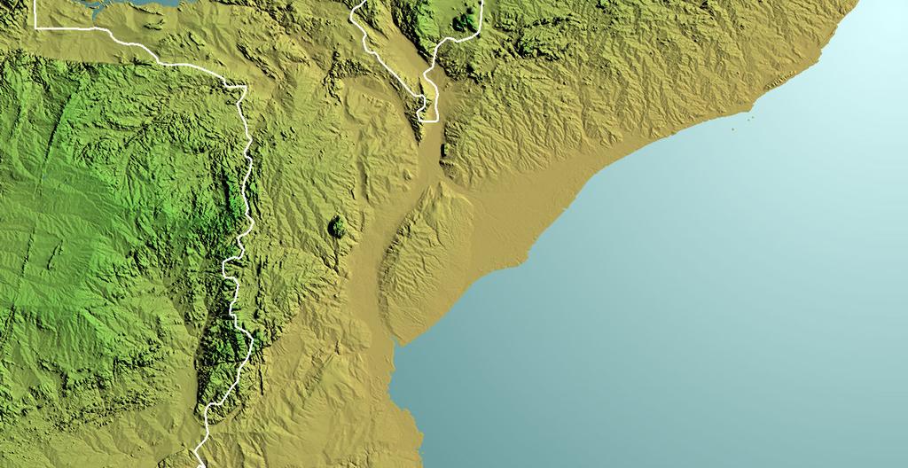
13 AERIAL SURVEY OF WILDLIFE IN THE NIASSA GAME RESERVE AND ADJACENT AREAS, MOZAMBIQUE, October INTRODUCTION The 2009 aerial survey of wildlife in the Niassa Reserve and adjacent areas in northern Mozambique was undertaken from 28 September to 19 October. This was the sixth survey of the area promoted and organised by the Sociedade para a Gestão e Desenvolvimento da Reserva do Niassa (SGDRN) and the data from these surveys provide information not only about the size but also of trends of the populations of the more numerous species. Previous surveys were carried out in 1998, 2000, 2002, 2004 and 2006 (Gibson 1998; Gibson 2000; Craig & Gibson 2002; Craig & Gibson 2004 Craig 2006). The Reserve is adjacent to Tanzania along the Rovuma River (Frontispiece and Fig. 1). It now incorporates the adjacent hunting blocks and is divided into 17 management units (Fig 2) of a total area of km2. The survey was based out of Mbatamela and also operated from airstrips at Catembe, Kambako, Sable and Valadim (Fig. 1). 36 E 37 E 38 E TANZANIA 12 S Niassa reserve Mbatamela Valadim Kambako Catembe Sable 13 S MOZAMBIQUE Figure 1: Survey areas showing survey bases Aerial Survey of Niassa Reserve and adjacent areas October 2009
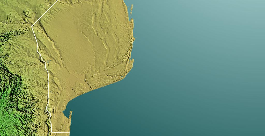
14 2 The 2004 and 2006 surveys also covered Chipanje-Chetu community-based natural resource management project area, on the western boundary of Niassa. This was also planned for 2009 but the resources were diverted towards surveying adjacent blocks of equivalent area along the southern boundary of Niassa including parts of 3 adjacent hunting concessions (Fig. 2). The results serve to provide a picture of wildlife distribution adjacent to the reserve that was no previously available. The additional area is km 2. The total area surveyed was km 2. Figure 2: Management units The survey was planned based on strata corresponding to the previous management units (see Appendix I) as the updated boundaries (Fig. 2) were not available at the planning stage. However, results are presented according to the new management units. As the updated outer boundaries are slightly different to the ones previously in use to design surveys, there ar small differences between the overall results of the survey (Appendix II) and those reported for the management blocks. The area surveyed as Niassa reserve was km 2 as opposed to for the actual reserve. Fig. 3 compares the surveyed and reporting areas.
 in a light aircraft (a Cessna 206) flying at a nominal height of 300 feet above the ground. As in the 2000, 2002, 2004 and 2006 surveys, the nominal sampling intensity was 10%.")

15 3 Figure 3: Comparison of surveyed area and updated boundaries As in previous surveys (1998, 2000, 2002, 2004 and 2006), the method of stratified systematic transect sampling was used (Norton Griffiths, 1978) in a light aircraft (a Cessna 206) flying at a nominal height of 300 feet above the ground. As in the 2000, 2002, 2004 and 2006 surveys, the nominal sampling intensity was 10%. This report follows a similar format to that used for the previous five surveys of the area. Section 2, Results, comprises maps showing the sightings and tables of estimates for each species. The estimated numbers and densities of animals are given for each of the management units within the survey area, as well as the overall totals. Section 3 provides a summary of other information recorded during the survey which may be directly relevant to the management of the area. Section 4, trends describes trends in the animal populations over the 6 surveys, while Section 5 is a brief discussion of the usefulness of the survey. Descriptions of methods are provided in Appendix I. Appendix II gives details of survey implementation, i.e. times, sampling intensities, calibration, etc. It also contains the original computer-generated tables of results for each of the sampling strata. That is, the conventionally analysed results according to the designed strata, as opposed to the further processed information in Section 2.
16 4 2 RESULTS FOR WILDLIFE A full list of species seen during the survey is provided in Appendix II. For each wildlife species in this section a sighting map is provided along with a table of estimates for each management unit. In the table the range refers to the range within which there is a 95% probability that the true number falls (i.e. it is the 95% confidence interval). Strictly, for most species this is actually the range within which 95% of independent estimates made by the same method would fall. The true value is likely to be higher on average because of undercounting bias. No. seen is the number of animals seen within sampling strips and No. out is the number seen outside of the sampling strips. Where animals were seen only outside of the sampling strips no estimate can be made by this method although the record shows that the species occurs. Wildlife species in this section are arranged in alphabetical order of their common names with the exception of :Elephant and buffalo, which are placed first and second respectively; monkeys, which are put next to baboons; crocodiles, which are placed with hippos; grysbok and klipspringer, which are placed after duiker; and carnivores, which are put together after Zebra. At the end other carcasses seen are reported for the first time in this series of surveys. Under elephants, elephant carcasses are tabulated and carcass ratios are given in a separate table. The density distribution of wildlife in the area in October 2009 (Fig. 4) is similar to that observed in previous years. Fig. 5 shows the distribution of biomass in large stock units (1LU = 450 kg). Biomass is less evenly spread because it is determined mainly by elephants. General wildlife density is mainly determined by individuals of the most abundant species, particularly duiker, which are more evenly distributed.

17 5 36 E 37 E 38 E 12 S 0 50km Number / Km 2 > /2-1 1/4-1/2 1/8-1/4 1/16-1/8 1/32-1/16 < 1/32 13 S Figure 4: Density distribution of wildlife 36 E 37 E 38 E 12 S Figure 5: Biomass in large stock units 0 50km LUs / Km 2 > /2-1 1/4-1/2 1/8-1/4 1/16-1/8 1/32-1/16 1/64-1/32 < 1/64 13 S
18 6 36 E 37 E 38 E 12 S Elephant family groups Elephant bulls 13 S 0 50km Figure 6: Elephant sightings Table 1: Elephant estimates Niassa blocks: Estimate Range No seen No out Density R R R R R R Jao Mecula L L L L L L L L L Totals Adjacent blocks: Negomano Majune Mt Mosale Totals

19 7 36 E 37 E 38 E 12 S 0 50km Number / Km 2 > /2-1 1/4-1/2 1/8-1/4 1/16-1/8 1/32-1/16 1/64-1/32 <1/64 13 S Figure 7: Density distribution of elephants Table 2: Estimates of elephants in family groups Niassa blocks: Estimate Range No seen No out Density R R R R R R Jao Mecula L L L L L L L L L Totals Adjacent blocks: Negomano Majune Mt Mosale Totals
20 8 Table 3: Elephant bulls Niassa blocks: Estimate Range No seen No out Density R R R R R R Jao Mecula L L L L L L L L L Totals Adjacent blocks: Negomano Majune Mt Mosale Totals E 37 E 38 E 12 S 0 50km Carcass 1 Carcass 2 Carcass 3 Carcass 4 13 S Figure 8: Elephant carcasses
21 9 Table 4: Elephant carcass stage 1 Niassa blocks: Estimate Range No seen No out Density R L Totals Table 5: Elephant carcass stage 2 Niassa blocks: Estimate Range No seen No out Density R R L L Totals Table 6: Elephant carcass stage 3 Niassa blocks: Estimate Range No seen No out Density R R R R L L L L L L L Totals Table 7: Elephant carcass stage 4 Niassa blocks: Estimate Range No seen No out Density R R R R R L L L L L L L Totals Adjacent blocks: Negomano Majune Totals
22 10 Table 8: All elephant carcasses Niassa blocks: Estimate Range No seen No out Density R R R R R R Jao Mecula L L2 L L L L L L L Totals Adjacent blocks: Negomano Majune Mt Mosale Totals Table 9: Carcass ratios Live Elephant Ratio Range Niassa blocks: elephants carcasses Total % R R R R R R Jao Mecula L L L L L L L L L Totals Adjacent blocks: Negomano Majune Mt Mosale Totals
23 11 Table 10: Buffalo Niassa blocks: Estimate Range No seen No out Density R R R R R R Jao Mecula L L L L L L L L L Totals Adjacent blocks: Negomano Majune Mt Mosale Totals E 37 E 38 E 12 S 13 S 0 50km Figure 9: Buffalo sightings
24 12 Table 11: Baboon Niassa blocks: Estimate Range No seen No out Density R R R R R5 R Jao Mecula L L L L4 L5 L6 L L L Totals Adjacent blocks: Negomano Majune Mt Mosale Totals E 37 E 38 E 12 S 13 S 0 50km Figure 10: Baboon sightings
25 13 Table 12: Vervet Monkey Niassa blocks: Estimate Range No seen No out Density R R2 R R4 R R Jao Mecula L1 L L L4 0 L L6 L7 L8 L Totals Adjacent blocks: Negomano Majune Mt Mosale Totals E 37 E 38 E 12 S 13 S 0 50km Figure 11: Monkey sightings
26 14 Table 13: Bushbuck Niassa blocks: Estimate Range No seen No out Density R R R R R R Jao Mecula L1 L L L4 L L L L L Totals Adjacent blocks: Negomano Majune Mt Mosale Totals E 37 E 38 E 12 S 13 S 0 50km Figure 12: Bushbuck sightings
27 15 Table 14: Bushpig Niassa blocks: Estimate Range No seen No out Density R R R3 R4 R5 R Jao - Mecula L L L L L5 L6 L7 L8 L Totals Adjacent blocks: Negomano Majune Mt Mosale Totals E 37 E 38 E 12 S 13 S 0 50km Figure 13: Bushpig sightings
28 16 Table 15: Duiker Niassa blocks: Estimate Range No seen No out Density R R R R R R Jao Mecula L L L L L L L L L Totals Adjacent blocks: Negomano Majune Mt Mosale Totals E 37 E 38 E 12 S 13 S 0 50km Figure 14: Duiker sightings
29 Table 16: Klipspringer Niassa blocks: Estimate Range No seen No out Density R L L L L Totals Adjacent blocks: Negomano Totals Table 17: Grysbok Niassa blocks: Estimate Range No seen No out Density R R L L L L Totals Adjacent blocks: Negomano Majune Mt Mosale Totals E 37 E 38 E 12 S Grysbok Klipspringer 13 S 0 50km Figure 15: Other small antelopes
30 18 Table 18: Eland Niassa blocks: Estimate Range No seen No out Density R R R R R R Jao Mecula L L L L L L L L L Totals Adjacent blocks: Negomano Majune Mt Mosale Totals E 37 E 38 E 12 S 13 S 0 50km Figure 16: Eland sightings
31 19 Table 19: Ground Hornbill Niassa blocks: Estimate Range No seen No out Density R R R R R R Jao Mecula L L L L L L L L L Totals Adjacent blocks: Negomano Majune Mt Mosale Totals E 37 E 38 E 12 S 13 S 0 50km Figure 17: Ground hornbill sightings
32 20 Table 20: Hartebeest Niassa blocks: Estimate Range No seen No out Density R R R R R R Jao Mecula L L L L L5 L L L L Totals Adjacent blocks: Negomano Majune Mt Mosale Totals E 37 E 38 E 12 S 13 S 0 50km Figure 18: Hartebeest sightings
33 21 Table 21: Hippopotamus Niassa blocks: Estimate Range No seen No out Density R R L L L L Totals Table 22: Crocodile Niassa blocks: Estimate Range No seen No out Density R L L L Totals Adjacent blocks: Mt Mosale Totals E 37 E 38 E 12 S Hippopotamus Crocodile 13 S 0 50km Figure 19: Hippopotamus and crocodile sightings
34 22 Table 23: Impala Niassa blocks: Estimate Range No seen No out Density R1 R2 R3 R4 R5 R Jao Mecula L1 L L L L L L L L Totals Adjacent blocks: Negomano Majune Mt Mosale Totals 36 E 37 E 38 E 12 S 13 S 0 50km Figure 20: Impala sightings
35 23 Table 24: Kudu Niassa blocks: Estimate Range No seen No out Density R R R R R R Jao Mecula L L L L L L L L L Totals Adjacent blocks: Negomano Majune Mt Mosale Totals E 37 E 38 E 12 S 13 S 0 50km Figure 21: Kudu Sightings
36 24 Table 25: Reedbuck Niassa blocks: Estimate Range No seen No out Density R R R R R5 R6 Jao Mecula L L L L L5 L6 L L L Totals Adjacent blocks: Negomano Majune Mt Mosale Totals E 37 E 38 E 12 S 13 S 0 50km Figure 22: Reedbuck sightings
37 25 Table 26: Sable Niassa blocks: Estimate Range No seen No out Density R R R R R R Jao Mecula L L L L L L L L L Totals Adjacent blocks: Negomano Majune Mt Mosale Totals E 37 E 38 E 12 S 13 S 0 50km Figure 23: Sable sightings
38 26 Table 27: Warthog Niassa blocks: Estimate Range No seen No out Density R R R R R R Jao Mecula L L L L L L L L L Totals Adjacent blocks: Negomano Majune Mt Mosale Totals E 37 E 38 E 12 S 13 S 0 50km Figure 24: Warthog sightings
39 27 Table 28: Waterbuck Niassa blocks: Estimate Range No seen No out Density R R R R R R Jao Mecula L L L L L L L L L Totals Adjacent blocks: Negomano Majune Mt Mosale Totals E 37 E 38 E 12 S 13 S 0 50km Figure 25: Waterbuck sightings
40 28 Table 29: Wildebeest Niassa blocks: Estimate Range No seen No out Density R1 R2 1 R3 R R R6 12 Jao Mecula L1 L2 L3 L4 L L L L L Totals Adjacent blocks: Negomano Majune Mt Mosale Totals E 37 E 38 E 12 S 13 S 0 50km Figure 26: Wildebeest sightings
41 29 Table 30: Zebra Niassa blocks: Estimate Range No seen No out Density R R R R R R Jao Mecula L1 L L L L L L L L Totals Adjacent blocks: Negomano Majune Mt Mosale Totals E 37 E 38 E 12 S 13 S 0 50km Figure 27: Zebra sightings
42 30 Table 31: Leopard Niassa blocks: Estimate Range No seen No out Density R Totals Table 32: Lion Niassa blocks: Estimate Range No seen No out Density R L L L9 1 Totals Table 33: Hyaena Niassa blocks: Estimate Range No seen No out Density R Totals E 37 E 38 E 12 S Lion Leopard Hyaena 13 S 0 50km Figure 28: Carnivore sightings
43 31 Table 34: Other Carcass stage 1 Niassa blocks: Estimate Range No seen No out Density L L Totals Table 35: Other Carcass stage 3 Niassa blocks: Estimate Range No seen No out Density R R R R R R L L L L L L Totals Adjacent blocks: Negomano Majune Totals Table 36: Other Carcass stage 4 Niassa blocks: Estimate Range No seen No out Density R R R R R L L L L L L Totals Adjacent blocks: Majune Totals
44 32 36 E 37 E 38 E 12 S Carcass 1 Carcass 3 Carcass 4 13 S 0 50km Figure 29: Other (non-elephant) carcasses including unidentified species
45 33 3 OTHER OBSERVATIONS This section describes attributes other than wildlife recorded during the survey. Fig. 30 and Table 37 show incidence of fires and burned areas at the time of the survey (some areas burned after they had been surveyed). Occurrences of surface water are reported for the first time (Fig. 31). Records were not made over the Lugenda and Rovuma rivers, which were flowing along their full lengths. Table 37: Percentage of area burnt Hot Cool Unburned total Niassa Reserve Adjacent blocks Total Observations relating to human activities are mapped in figs
46 34 36 E 37 E 38 E 12 S Cool burn Hot burn Active fire 13 S 0 50km Figure 30: Fire 36 E 37 E 38 E 12 S 13 S 0 50km Figure 31: Water
47 35 36 E 37 E 38 E Gomba Negomano Chamba Milepa Nalama Mitope Matondavela Mecula Macalange 12 S Ntimbo Nampaquesso Mbamba Nkalapa Nahavera Mavago Msawise Extensive cleared land Other cultivation Tobacco Observed dwellings Named settlements 13 S 0 50km Figure 32: Cultivation and settlement 36 E 37 E 38 E 12 S Fishing camp Fish trap Canoe Man 13 S 0 50km Figure 33: Fishing
48 36 Table 38: Small livestock (sheep or goats) Niassa blocks: Estimate Range No seen No out Density L L L Totals E 37 E 38 E 12 S 13 S 0 50km Figure 34: Sheep or goats
49 37 36 E 37 E 38 E 12 S Snareline Poacher s camp 13 S 0 50km Figure 35: Illegal hunting 36 E 37 E 38 E 12 S Logging Gold panning 13 S 0 50km Figure 36: Other illegal activities
50 38 4 TRENDS Trend parameters for wildlife species are given in Table 39. The natural logarithm of the estimates was used in the regressions. In this case the slope of the regression is r, the instantaneous rate of increase. Method was as in the previous report (Craig 2006). The last data point is 3 years from the previous when, ideally, the time points should be evenly spaced. However, this is unlikely to be of major importance. Confidence intervals for r are given. Any r whose lower confidence interval is less than 0 is not statistically significant. The significance levels (p) of the trends are given. Any p which is less than 0.05 is significant at the 5% level. Graphs of population changes are shown below for populations where the change is significant (Figs 37 49). A graph is provided for Wildebeest in addition. The fitted exponential trend line is shown in each case except for sable. A significant fit does not necessarily imply the increase really is exponential. However, fitting a more complicated relationship would be difficult to justify with this number of points in the time series. Change over time is also illustrated for small livestock and snaring (Figs 50 51). Table 39: Wildlife trends Estimates Rate 95% Range of r Prob Species r L U p Elephants * Elephant carcasses Buffalo Bushbuck Bushpig Crocodile Duiker Eland * Hartebeest * Hippopotamus * Impala * Kudu Reedbuck * Sable * Warthog * Waterbuck ** Wildebeest Zebra ** Ground hornbill ** All Wildlife **
51 39 Figure 37: Trend of all wildlife Figure 38: Elephants Figure 39: Eland
52 40 Figure 40: Ground hornbill Figure 41: Hartebeest Figure 42: Hippopotamus
53 41 Figure 43: Impala Figure 44: Reedbuck Figure 45: Sable
54 42 Figure 46: Warthog Figure 47: Waterbuck Figure 48: Wildebeest
55 43 Figure 49: Zebra Figure 50: Small livestock (sheep or goats) Figure 51: Snarelines seen
56 44 5 SUMMARY AND DISCUSSION The 2009 Niassa survey is the sixth survey of the area since The data set is improving in its ability to describe trends, as evidenced by the increased number of species for which significant trends have been detected. There is a large increase in the elephant estimate since This comes after a run of similar estimates in Numbers could have increased this dramatically if elephants moved into the area; say in response to drought or disturbance elsewhere. The results from the adjacent blocks show the continuity of wildlife distribution with surrounding areas; the system appears to be an open one. On the other hand, the fluctuations perceived could be random variation in the estimates around a steady increase (Fig. 38). Bias in some estimates would aggravate this; say if there was a downward bias in the 2006 result or an upward one in The overall trend is not significantly different from what would be expected of natural increase. With the information available (i.e. six points on the graph) it is not possible to distinguish between alternatives. The number of elephant carcasses detected has increased significantly. However, with the increase in the elephant estimates, the overall carcass ratio is similar to previous years (Table 9). Carcass ratios are, however, notably and significantly high in some blocks (R6 and L6). There has also been an apparent increase in recent carcasses (stages 1 and 2): 13 were seen (Tables 4 and 5) as opposed to none in These also are mainly in blocks R6 and L6. That this increase is due to illegal hunting is suggested by the occurrence, in one instance, of a pair of carcasses at the same location and other instances where carcasses are separated by a short distance. There has been a significant increase in wildlife estimates overall (fig. 37) and eleven species have increased significantly over the series of surveys. This reflects the build up of information over time. The buffalo estimate increased in this survey but, given the high intrinsic variability of results for buffalo (see 2006 report) it is not possible from these surveys to say what the trend is. Wildebeest estimates also suffer from the problem of variable group size and, in addition, small numbers and therefore little information. However, it can be said that, on the balance of probabilities, wildebeest are likely to be increasing. Sable have increased significantly over the period since 1998, though most of that increase was in the first 4 years. It therefore appears that an exponential curve is not a good description of sable increase, so the fitted curve is not shown on Fig. 45. Human activities have increased. Fishing only slightly the big increase was 2004 to 2006 and it is not possible to say how much of the increase is due to increased attention given to this by the survey crew. The survey detected 1.3% of the area as extensively cleared fields. However, agriculture is concentrated (Fig. 32) and only a few transects cut it, so this is a very crude estimate. A regular dedicated monitoring of this is required. The estimate of small livestock increased markedly (Fig. 50) but, in view of the small number of sightings, any estimate of the real magnitude of that increase is unreliable at this stage.
57 45 Snaring has increased (Fig. 51) and is slightly more extensive than in 2006 (Fig. 35). The local increases in elephant carcasses described above are at least partly due to illegal hunting. Illegal gold panning and logging were detected for the first time (Fig. 36). Logging took place mainly in block L9 where planks were seen being moved illegally across the Rovuma to a storage yard in Tanzania. The survey estimated about 2700 instances of logging in the reserve (240 were recorded). It is not known how many trees or what tonnage of timber each site accounts for. In one case a recently cut tree could be seen to be pod mahogany; Afzelia quanzensis. Although fewer wildlife species were seen in block L9 (stratum AN and AS) than in the previous survey this is weak evidence of the effects of increased illegal activity here. Wildlife densities were always low in this block. The results again emphasize the need for more points in time to measure trends, greater spatial coverage to place Niassa in perspective to its surroundings and more targeted monitoring to obtain better information on surveyed attributes where necessary. 6 ACKNOWLEDGEMENTS The survey was funded by Fauna and Flora International. David and Gerda le Poidevin of Missionary Aviation Fellowship provided invaluable logistical assistance to the survey crew. Safrique, Johann Calitz Safaris, LDA and Kambako Safaris provided the facilities of their camps and provided additional logistic support. In this regard the personal attention of Jumbo Moore, Edwin Young, Matthew Hulley-Miller, and Guy Ferreira is gratefully acknowledged. DG Ecological is grateful to Ms Anabela Rodrigues and Vernon Booth of the Sociedade para a Gestão e Desenvolvimento da Reserva do Niassa for initiating and organising the survey.
58 46 7 REFERENCES Craig G.C Aerial survey of Wildlife in the Niassa Reserve and Surrounds, Mozambique, October Sociedade para a Gestão e Desenvolvimento da Reserva do Niassa Craig G.C. & D. St.C. Gibson 2002 Aerial survey of Wildlife in the Niassa Game Reserve and Hunting Concessions, Moçambique, October Sociedade para a Gestão e Desenvolvimento da Reserva do Niassa Craig G.C. & D. St.C. Gibson 2004 Aerial survey of Wildlife in the Niassa Game Reserve and Hunting Concessions, Moçambique, October Sociedade para a Gestão e Desenvolvimento da Reserva do Niassa Douglas-Hamilton I Counting elephants from the air - total counts. In: Studying Elephants. Ed. K. Kangwana. AWF Technical Handbook series, African Wildlife FoundationNairobi, Kenya. Gasaway W.C., S.D. dubois, D.J. Reed and S.J. Harbo Estimating moose population parameters from aerial surveys. Biological Papers of the University of Alaska No pp. Gibson D. St.C Aerial survey of Wildlife in and around Niassa Game Reserve, Moçambique, October Sociedade para a Gestão e Desenvolvimento da Reserva do Niassa Gibson D. St.C Aerial survey of Wildlife in the Niassa Reserve and Hunting Concessions, Moçambique, October/November Sociedade para a Gestão e Desenvolvimento da Reserva do Niassa Jolly G.M Sampling methods for aerial censuses of wildlife populations. E. Afr. Agricultural & Forestry Journal - special issue: Norton Griffiths M Counting Animals. Handbook No. 1, African Wildlife Foundation, Nairobi, Kenya.
59 47 APPENDIX I: METHODS The method of stratified systematic transect sampling (Norton Griffiths, 1978) was used throughout the survey. A Cessna 206 equipped with a radar altimeter and Global Positioning Systems (GPS) was used. Maps of the stratum boundaries and transects were uploaded to a portable GPS and used for accurate navigation along the transects. A height of 300ft above ground level was maintained using the radar altimeter. Positions of the aircraft were recorded at 20 second intervals to record the tracks flown. The aircraft was flown along the transects at a speed of around 90 knots. A pair of observers seated in the back called out sightings of animals seen within the sampling strip (see Calibration, below). A recorder seated in the front recorded these sightings, noting the species and number seen (herds were not photographed). The position of each sighting was recorded on a second GPS and the record number entered on the data sheet for matching with the sighting during analysis. Previously position was recorded on the data sheet during flight but this survey s method eliminates writing errors and some data input errors, though it has some drawbacks. Note was made approximately twice a minute of the height above ground, as indicated by the radar altimeter, to allow the calculation of the mean height for each transect. The time at which the flight along each transect was started and ended was also recorded to provide a record of the average speed. On this survey the aircraft was crewed by D le Poidevin (pilot), W Veal (alternate pilot), C Craig (recorder), N Chitemamuswe (left observer), D Chipesi (right observer). Stratification and sampling effort The strata used for the Niassa Reserve were the same as those used in 2004 and 2006 (Craig and Gibson, 2004, Craig, 2006) (Fig. 52). The adjacent survey area was created by taking a 25 km - wide strip along the southern boundary of the reserve, divided into 3 strata corresponding to parts of adjacent hunting concessions. All strata were sampled at a nominal intensity of 10% by spacing transects at 4km intervals (Fig.53) assuming a total strip width of 400m. Actual sampling intensities are modified by the calibrated strip width and mean height flown. Sampling intensity for each stratum is: total transect area / stratum area. The area of a transect in km 2 is: transect length in km x (calibrated transect width in metres / 1000) x mean height in feet / 300. Details of realised sampling intensities are given in Appendix II (Table 39).


60 48 Figure 52: Survey strata Figure 53: Transects
61 49 Transect Selection Transects are oriented to follow ecological gradients (i.e. more or less at right angles to major rivers) in each stratum and, where possible, to eliminate long positioning flights between transects and to minimise direct approaches to high escarpments. The lateral position of the first transect in a stratum is selected at random and remaining transects are spaced at successive 4 km intervals from that. Each survey uses a new and different selection of transects. Calibration The boundaries of strips on each side of the aircraft were defined by a pair of rods attached to the lift struts. The width of the strips was measured empirically by flying at various heights and at right angles across an airstrip on which numbers had been painted at 10m intervals. The observers called out the outermost and innermost numbers seen within the strip, and the difference between the numbers was used to calculate the calibrated strip width for 300 ft. above ground. The rods were adjusted to provide a strip width of about 200m per side. Elephant sightings, carcass classification and ratios Elephants were recorded as being in family groups or bull groups, defined as follows: Family groups - herds in which females and young are present. Any bulls in the group are counted as part of the group. Bull groups - single bulls or herds which contain no females or juveniles. Carcasses were classified into three categories according to their estimated time since death (Douglas-Hamilton et al. 1996). These are: Carcass 1 - Carcass 2 - Carcass 3 - Carcass 4 - Fresh (<1 month): skin covered, with flesh present giving the body a rounded appearance; vultures often present; ground still moist from body fluids. Recent (<1 year): rot patch still visible; hide still attached to carcass; bones not scattered Old (>1 year): skin absent; bones not scattered; vegetation regrown in rot patch. Very old (up to 10 years): bones bleached and scattered. Carcasses of other species were also classified, as far as possible, according to the same criteria. Carcass ratios Carcass ratio is defined as the number of carcasses / (carcasses + live elephants). In Table 9 the range of the ratio estimate has been calculated from the binomial variance of the number of carcasses drawn from a total population with the observed proportion of carcasses. This is a bit of an oversimplification as it gives a lower confidence interval
62 50 overlapping zero for small numbers of carcasses (shown as a lower limit of zero in Table 9). However, it serves to identify areas with carcass ratios in excess of 5%, the level at around which the ratio is expected to be in a population with the base natural mortality rate. Searching rate The mean searching rate (km 2 /min) for each stratum was calculated from the total sample area divided by the total time on transects. This gives an indication of the survey quality (see Appendix II, Table 39). Data Analysis Jolly s (1969) method for blocks of unequal size was used to calculate estimates of density and variance for each species in each stratum. Full details of the method are given in previous survey reports (Gibson 1998, 2000, Craig & Gibson 2002, 2004). In this survey the actual estimates for the design strata are of less interest than estimates of species in the recently revised management units (Fig. 2). Estimates for the current management units were derived as follows: each sighting was allocated to the management unit in which it was made, determined by which map polygon it fell into; the number of animals in a sighting was multiplied by the inverse of the sampling intensity of the stratum in which it was seen; the estimate for the management unit was derived as the sum of these products for the sightings within the unit. Approximate species variances for the different management units were derived by partitioning the total survey variance among the management units using weights based on the number seen in the unit and the number/variance relationship over all strata. This conserves both the total estimate and the total variance for each species. Small discrepancies occur because the revised outer boundary of Niaasa does not quite coincide with the survey boundary, which also requires a correction of the adjacent survey area (Fig. 3). Distribution mapping Sighting maps were generated for all species and other observations and are represented by symbols placed at the GPS location of sightings. Contour maps are intended to give an overview of the average densities of animals in different parts of the area at the time of year when surveys are done. Sighting maps do not do this because the number of animals in a sighting (i.e. group size) is not taken into account and only an impression of density of sightings is given. However, sighting maps do not gloss over the data and give a direct view of the information collected. In this report only elephants and all species are mapped by density contours. The method is described in the previous survey report (Craig, 2006). Maps are unprojected (i.e. in geographic coordinates). In all other than those with density contours or topography the x axis has been compressed to equalise the scales on the x and y axes. Topography was developed from NASA Shuttle Radar Topography data.
Parque Nacional do Limpopo AERIAL WILDLIFE CENSUS
 2013 Parque Nacional do Limpopo AERIAL WILDLIFE CENSUS Alan Stephenson Wildlife Management Services Index Introduction.2 Methodology. 2 Results 5 Maps 6 Discussion & Comments.. 38 Acknowledgements 50 References
BOTSWANA ENVIRONMENT STATISTICS: WILDLIFE DIGEST 2014
 Published by Statistics Botswana Private Bag 0024, Gaborone Phone: 3671300 Email: info@statsbots.org.bw BOTSWANA ENVIRONMENT STATISTICS: WILDLIFE DIGEST 2014 Contact Unit: Environment Statistics Unit Phone:
Aerial wildlife count of the Parque Nacional da Gorongosa, Mozambique, October 2016 Approach, results and discussion
 Aerial wildlife count of the Parque Nacional da Gorongosa, Mozambique, October 2016 Approach, results and discussion Dr Marc Stalmans & Dr Mike Peel November 2016 Table of contents Summary 3 1. Survey
Aerial wildlife count of the Parque Nacional da Gorongosa, Mozambique, October 2018
 Aerial wildlife count of the Parque Nacional da Gorongosa, Mozambique, October 2018 Dr Marc Stalmans, Dr Mike Peel & Dominique Gonçalves November 2018 Our milestones For the first time ever, more than
REPORT ON THE AERIAL GAME CENSUS OF THE NORTHERN TULI GAME RESERVE, BOTSWANA. Compiled by J. Selier Mashatu Game Reserve August 2008.
 REPORT ON THE AERIAL GAME CENSUS OF THE NORTHERN TULI GAME RESERVE, BOTSWANA Compiled by J. Selier Mashatu Game Reserve August 2008 Introduction No form of wildlife management whether it is the establishment
Elephant Survey July Eastern Okavango Panhandle, Botswana (NG11, NG12 and NG13)
") Elephant Survey July 2010 Eastern Okavango Panhandle, Botswana (NG11, NG12 and NG13) Report 2010 Conducted by Okavango Elephant and People Research Project & Elephants Without Borders Prepared By Ms Anna
Elephant Survey July 2010 Eastern Okavango Panhandle, Botswana (NG11, NG12 and NG13) Report 2010 Conducted by Okavango Elephant and People Research Project & Elephants Without Borders Prepared By Ms Anna
AURORA WILDLIFE RESEARCH
 AURORA WILDLIFE RESEARCH Kim Poole 2305 Annable Rd. Nelson, BC, V1L 6K4 Canada Tel: (250) 825-4063; Fax: (250) 825-4073 e-mail: klpoole@shaw.ca 27 April 2005 Mike Gall Conservation Specialist and Glenn
Large herbivore population estimates for Thanda Private Game Reserve and Mduna Royal Reserve. September
 Large herbivore population estimates for Thanda Private Game Reserve and Mduna Royal Reserve September 2012-1 - Large herbivore population estimates for Thanda Private Game Reserve and Mduna Royal Reserve
HOTFIRE WILDLIFE MANAGEMENT MODEL A CASE STUDY
 1 HOTFIRE WILDLIFE MANAGEMENT MODEL A CASE STUDY Sub-theme: Economics / business venture, livelihood strategies Format: Poster Bruce Fletcher Hotfire Hunting and Fishing Safaris P O Box 11 Cathcart 5310
STATUS OF WILDLIFE POPULATIONS AND LAND DEGRADATION IN BOTSWANA S FOREST RESERVES AND CHOBE DISTRICT
 STATUS OF WILDLIFE POPULATIONS AND LAND DEGRADATION IN BOTSWANA S FOREST RESERVES AND CHOBE DISTRICT Michael Chase Elephants Without Borders PO Box 682 Kasane Tel: ++267 6250505 Email: er@info.bw April
Aboriginal and Torres Strait Islander Life Expectancy and Mortality Trend Reporting
 Aboriginal and Torres Strait Islander Life Expectancy and Mortality Trend Reporting Technical Report December 2015 Amended May 2016 Authors: Clare Coleman, Nicola Fortune, Vanessa Lee, Kalinda Griffiths,
Giraffe abundance and demography in relation to food supply, predation and poaching
 Giraffe abundance and demography in relation to food supply, predation and poaching Megan Strauss PhD Candidate, Ecology, Evolution & Behavior Graduate Program University of Minnesota www.serengetigiraffeproject.org
HOW TO IMPROVE HIGH-FREQUENCY BUS SERVICE RELIABILITY THROUGH SCHEDULING
 HOW TO IMPROVE HIGH-FREQUENCY BUS SERVICE RELIABILITY THROUGH SCHEDULING Ms. Grace Fattouche Abstract This paper outlines a scheduling process for improving high-frequency bus service reliability based
2009 Clearwater Area Sheep
 2009 Clearwater Area Sheep Section Authors: Chiarastella Feder and Shevenell Webb Suggested Citation: Feder, C. and S. Webb. 2009. Clearwater Area Sheep. Pages 22 25. In: N. Webb and R. Anderson. Delegated
Biol (Fig 6.13 Begon et al) Logistic growth in wildebeest population
 Logistic growth in wildebeest population") Biol 303 1 Interspecific Competition Outline Intraspecific competition = density dependence Intraspecific and interspecific competition Limiting resources Interference vs exploitation Effects on population
Biol 303 1 Interspecific Competition Outline Intraspecific competition = density dependence Intraspecific and interspecific competition Limiting resources Interference vs exploitation Effects on population
Biodiversity Studies in Gorongosa
 INTRODUCTION Gorongosa National Park is a 1,570-square-mile protected area in Mozambique. Decades of war, ending in the 1990s, decimated the populations of many of Gorongosa s large animals, but thanks
Accounting for the water use by wildlife in Botswana
 Accounting for the water use by wildlife in Botswana Paper for the 22 nd Meeting of the London Group on Environmental Accounting Oslo, Norway 2830 September 2016 Michael Vardon 1, Ogopotse Batlokwa Pule
Accommodation Survey: November 2009
 Embargoed until 10:45am 19 January 2010 Accommodation Survey: November 2009 Highlights Compared with November 2008: International guest nights were up 2 percent, while domestic guest nights were down 1
Snapshot Safari: A standardized
 Snapshot Safari: A standardized program for assessing population and behavioral dynamics of large mammals Craig Packer, Meredith Palmer & Sarah Huebner Department EEB, University of Minnesota & School
Aboriginal and Torres Strait Islander Life Expectancy and Mortality Trend Reporting to 2014
 Aboriginal and Torres Strait Islander Life Expectancy and Mortality Trend Reporting to 2014 Technical Report June 2016 Authors: Clare Coleman, Nicola Fortune, Vanessa Lee, Kalinda Griffiths, Richard Madden
Workshop on Co-Management Models of Conservation Areas in Mozambique, 25 July 2017, Maputo
 Workshop on Co-Management Models of Conservation Areas in Mozambique, 25 July 2017, Maputo Gorongosa declared National Park in 1960 An aerial census of the rift valley floor of the Gorongosa National
Northeast Stoney Trail In Calgary, Alberta
 aci Acoustical Consultants Inc. 5031 210 Street Edmonton, Alberta, Canada T6M 0A8 Phone: (780) 414-6373, Fax: (780) 414-6376 www.aciacoustical.com Environmental Noise Computer Modelling For Northeast Stoney
Aviation Trends Quarter
 Aviation Trends Quarter 4 214 Contents Introduction... 2 1. Historical overview of traffic see note 5 on p.15... 3 a. Terminal passengers... 4 b. Commercial flights... 5 c. Cargo tonnage... 6 2. Terminal
You can learn more about the trail camera project and help identify animals at WildCam Gorongosa (
 INTRODUCTION Gorongosa National Park is a 1,570-square-mile protected area in Mozambique. After several decades of war devastated Gorongosa s wildlife populations, park scientists and conservation managers
HEATHROW COMMUNITY NOISE FORUM
 HEATHROW COMMUNITY NOISE FORUM 3Villages flight path analysis report January 216 1 Contents 1. Executive summary 2. Introduction 3. Evolution of traffic from 25 to 215 4. Easterly departures 5. Westerly
Species: Wildebeest, Warthog, Elephant, Zebra, Hippo, Impala, Lion, Baboon, Warbler, Crane
 INTRODUCTION Gorongosa National Park is a 1,570-square-mile protected area in Mozambique. Decades of war, ending in the 1990s, decimated the populations of many of Gorongosa s large animals, but thanks
RESULTS OF CENSUSES OF ELEPHANT, BUFFALO, GIRAFFE AND GREVY S ZEBRA COUNTED IN FIVE KEY ECOSYSTEMS CONDUCTED IN 2016 AND 2017.
 RESULTS OF CENSUSES OF ELEPHANT, BUFFALO, GIRAFFE AND GREVY S ZEBRA COUNTED IN FIVE KEY ECOSYSTEMS CONDUCTED IN 2016 AND 2017. The Ministry of Environment and Natural Resources has released results of
Day 1: NAIROBI / AMBOSELI
 Day 1: NAIROBI / AMBOSELI This morning, you are met by a CATS Africa representative for meet and greet. After a short briefing on your safari depart with the professional driver/guide for the drive south
SELOUS NIASSA WILDLIFE CORRIDOR
 THE UNITED REPUBLIC OF TANZANIA Ministry of Natural Resources and Tourism WILDLIFE DIVISION BACKGROUND INFORMATION TO SELOUS NIASSA WILDLIFE CORRIDOR Rudolf Hahn Technical Adviser SNWC/UNDP-GEF/GTZ-IS
LUSAKA AGREEMENT TASK FORCE (LATF)
") SUMMARY REPORT ON SEIZURE DATA IN WILDLIFE ENFORCEMENT MONITORING SYSTEM (WEMS) MARCH 2015 Website: http://lusakaagreement.org/ Email: Administrator@lusakaagreement.org; Tel. +254 722 204 008/9 P.O Box:
SUMMARY REPORT ON SEIZURE DATA IN WILDLIFE ENFORCEMENT MONITORING SYSTEM (WEMS) MARCH 2015 Website: http://lusakaagreement.org/ Email: Administrator@lusakaagreement.org; Tel. +254 722 204 008/9 P.O Box:
Aerial Survey Standards and Guidelines for the Pan-African Elephant Aerial Survey 2014
 Aerial Survey Standards and Guidelines for the Pan-African Elephant Aerial Survey 2014 Principal Investigator March 2014 Page 1 of 21 Table of Contents Introduction... 3 1 Guidelines... 4 1.1 Comparability
POPULATION ESTIMATES FOR PEARY CARIBOU (MINTO INLET HERD), DOLPHIN AND UNION CARIBOU, AND MUSKOX ON NORTHWEST VICTORIA ISLAND, NT, JULY 2005
, DOLPHIN AND UNION CARIBOU, AND MUSKOX ON NORTHWEST VICTORIA ISLAND, NT, JULY 2005") POPULATION ESTIMATES FOR PEARY CARIBOU (MINTO INLET HERD), DOLPHIN AND UNION CARIBOU, AND MUSKOX ON NORTHWEST VICTORIA ISLAND, NT, JULY 2005 John A. Nagy 1, Anne Gunn 2, and Wendy H. Wright 1 1 Department
POPULATION ESTIMATES FOR PEARY CARIBOU (MINTO INLET HERD), DOLPHIN AND UNION CARIBOU, AND MUSKOX ON NORTHWEST VICTORIA ISLAND, NT, JULY 2005 John A. Nagy 1, Anne Gunn 2, and Wendy H. Wright 1 1 Department
POPULATION ESTIMATES FOR PEARY CARIBOU (MINTO INLET HERD), DOLPHIN AND UNION CARIBOU, AND MUSKOX ON NORTHWEST VICTORIA ISLAND, NT, JULY 1998
, DOLPHIN AND UNION CARIBOU, AND MUSKOX ON NORTHWEST VICTORIA ISLAND, NT, JULY 1998") POPULATION ESTIMATES FOR PEARY CARIBOU (MINTO INLET HERD), DOLPHIN AND UNION CARIBOU, AND MUSKOX ON NORTHWEST VICTORIA ISLAND, NT, JULY 1998 John A. Nagy 1, Nic Larter 2, and Wendy H. Wright 1 1 Department
POPULATION ESTIMATES FOR PEARY CARIBOU (MINTO INLET HERD), DOLPHIN AND UNION CARIBOU, AND MUSKOX ON NORTHWEST VICTORIA ISLAND, NT, JULY 1998 John A. Nagy 1, Nic Larter 2, and Wendy H. Wright 1 1 Department
Labrador - Island Transmission Link Target Rare Plant Survey Locations
 27-28- Figure: 36 of 55 29-28- Figure: 37 of 55 29- Figure: 38 of 55 #* Figure: 39 of 55 30- - east side Figure: 40 of 55 31- Figure: 41 of 55 31- Figure: 42 of 55 32- - secondary Figure: 43 of 55 32-
Analysing the performance of New Zealand universities in the 2010 Academic Ranking of World Universities. Tertiary education occasional paper 2010/07
 Analysing the performance of New Zealand universities in the 2010 Academic Ranking of World Universities Tertiary education occasional paper 2010/07 The Tertiary Education Occasional Papers provide short
Aviation Trends. Quarter Contents
 Aviation Trends Quarter 3 2014 Contents Introduction... 2 1. Historical overview of traffic... 3 a. Terminal passengers... 4 b. Commercial flights... 5 c. Cargo tonnage... 6 2. Terminal passengers at UK
Estimating the Risk of a New Launch Vehicle Using Historical Design Element Data
 International Journal of Performability Engineering, Vol. 9, No. 6, November 2013, pp. 599-608. RAMS Consultants Printed in India Estimating the Risk of a New Launch Vehicle Using Historical Design Element
Aviation Trends. Quarter Contents
 Aviation Trends Quarter 1 2013 Contents Introduction 2 1 Historical overview of traffic 3 a Terminal passengers b Commercial flights c Cargo tonnage 2 Terminal passengers at UK airports 7 3 Passenger flights
ANNEX C. Maximum Aircraft Movement Data and the Calculation of Risk and PSZs: Cork Airport
 ANNEX C Maximum Aircraft Movement Data and the Calculation of Risk and PSZs: Cork Airport CONTENTS C1 INTRODUCTION C1 C2 SUMMARY OF INPUT DATA C2 C3 AIRCRAFT CRASH RATE C5 C3.1 AIRCRAFT CLASSIFICATION
GUIDE TO THE DETERMINATION OF HISTORIC PRECEDENCE FOR INNSBRUCK AIRPORT ON DAYS 6/7 IN A WINTER SEASON. Valid as of Winter period 2016/17
 GUIDE TO THE DETERMINATION OF HISTORIC PRECEDENCE FOR INNSBRUCK AIRPORT ON DAYS 6/7 IN A WINTER SEASON Valid as of Winter period 2016/17 1. Introduction 1.1 This document sets out SCA s guidance for the
INTERNATIONAL BIRD STRIKE COMMITTEE IBSC27 / WP V-4 Athens, May 2005
 INTERNATIONAL BIRD STRIKE COMMITTEE IBSC27 / WP V-4 Athens, 23-27 May 2005 BIRD STRIKE DATA ANALYSIS AT SOUTH AFRICAN AIRPORTS AND SPATIAL REPRESENTATION OF BIRD PATROLS IN RELATION TO BIRD STRIKE OCCURRENCES.
12 NIGHT/13 DAY FAMILY SAFARI NORTHERN TANZANIA
 12 NIGHT/13 DAY FAMILY SAFARI NORTHERN TANZANIA Day One - Lake Manyara On arrival into Kilimanjaro you are met and transferred directly to Lake Manyara National Park. Located 125 km west of Arusha town,
Comparative Densities of Tigers (Panthera tigris tigris) between Tourism and Non Tourism Zone of Pench Tiger Reserve, Madhya Pradesh- A brief report
 between Tourism and Non Tourism Zone of Pench Tiger Reserve, Madhya Pradesh- A brief report") Comparative Densities of Tigers (Panthera tigris tigris) between Tourism and Non Tourism Zone of Pench Tiger Reserve, Madhya Pradesh- A brief report Submitted by Principal investigators Prof. (Dr.) K.
Comparative Densities of Tigers (Panthera tigris tigris) between Tourism and Non Tourism Zone of Pench Tiger Reserve, Madhya Pradesh- A brief report Submitted by Principal investigators Prof. (Dr.) K.
MIGRATION. 09 August THEGREAT WILDLIFE PHOTOGRAPHY TOUR TO MAASAI MARA AND LAKE NAKURU. 5 Nights at Mara Triangle 2 Nights at Lake Nakuru
 P R E S E N T S 09 August THEGREAT MIGRATION WILDLIFE PHOTOGRAPHY TOUR TO MAASAI MARA AND LAKE NAKURU 2018 5 Nights at Mara Triangle 2 Nights at Lake Nakuru TM INTRODUCTION THE GREAT MIGRATION Each year
Produced by: Destination Research Sergi Jarques, Director
 Produced by: Destination Research Sergi Jarques, Director Economic Impact of Tourism Epping Forest - 2014 Economic Impact of Tourism Headline Figures Epping Forest - 2014 Total number of trips (day & staying)
This Advisory Circular relates specifically to Civil Aviation Rule Parts 121, 125, and 135.
 Advisory Circular AC 119-4 Revision 1 Passenger, Crew and Baggage Weights 28 October 2005 General Civil Aviation Authority Advisory Circulars contain information about standards, practices, and procedures
Six Day Program Serengeti, NgoroNgoro, Lake Manyara
 Six Day Program Serengeti, NgoroNgoro, Lake Manyara When it comes to picking your next family holiday destination, Africa is the best destination. Nothing more incredible than heading out on safari together
Appendix B Ultimate Airport Capacity and Delay Simulation Modeling Analysis
 Appendix B ULTIMATE AIRPORT CAPACITY & DELAY SIMULATION MODELING ANALYSIS B TABLE OF CONTENTS EXHIBITS TABLES B.1 Introduction... 1 B.2 Simulation Modeling Assumption and Methodology... 4 B.2.1 Runway
Aviation Trends. Quarter Contents
 Aviation Trends Quarter 3 215 Contents Introduction... 2 1. Historical overview of traffic... 3 a. Terminal passengers... 4 b. Commercial flights... 5 c. Cargo tonnage... 6 2. Terminal passengers at UK
AERIAL SURVEY OF ELEPHANTS IN NORTH EAST NAMIBIA SEPTEMBER OCTOBER 2007
 AERIAL SURVEY OF ELEPHANTS IN NORTH EAST NAMIBIA SEPTEMBER OCTOBER 2007 Commissioned b y C O N S E R V A T I O N I N T E R N A T I O N A L R e p ort Prepared by Michael Chase PO Box 682 Kasane Botswana
NIMALI SAFARI EXPERIENCE: Below is the itinerary for 6 nights & 7 days TARANGIRE, NGORONGORO CRATER & SERENGETI
 NIMALI SAFARI EXPERIENCE: Below is the itinerary for 6 nights & 7 days TARANGIRE, NGORONGORO CRATER & SERENGETI Itinerary Overview: Day 1, 2 & 3: Day 4, 5 & 6: Nimali Tarangire Luxury Camp (GP) Singita
Preliminary report on the apex predators of Banhine National Park and the potential Limpopo-Banhine corridor
 Preliminary report on the apex predators of Banhine National Park and the potential Limpopo-Banhine corridor Leah Andresen, Kristoffer Everatt & Graham Kerley Centre for African Conservation Ecology Nelson
MEASURING ACCESSIBILITY TO PASSENGER FLIGHTS IN EUROPE: TOWARDS HARMONISED INDICATORS AT THE REGIONAL LEVEL. Regional Focus.
 Regional Focus A series of short papers on regional research and indicators produced by the Directorate-General for Regional and Urban Policy 01/2013 SEPTEMBER 2013 MEASURING ACCESSIBILITY TO PASSENGER
Proceedings of the 54th Annual Transportation Research Forum
 March 21-23, 2013 DOUBLETREE HOTEL ANNAPOLIS, MARYLAND Proceedings of the 54th Annual Transportation Research Forum www.trforum.org AN APPLICATION OF RELIABILITY ANALYSIS TO TAXI-OUT DELAY: THE CASE OF
Aviation Trends. Quarter Contents
 Aviation Trends Quarter 1 Contents Introduction... 2 1. Historical overview of traffic... 3 a. Terminal passengers... 4 b. Commercial flights... 5 c. Cargo tonnage... 6 2. Terminal passengers at UK airports...
CONGESTION MONITORING THE NEW ZEALAND EXPERIENCE. By Mike Curran, Manager Strategic Policy, Transit New Zealand
 CONGESTION MONITORING THE NEW ZEALAND EXPERIENCE 26 th Australasian Transport Research Forum Wellington New Zealand 1-3 October 2003 By, Manager Strategic Policy, Transit New Zealand Abstract New Zealand
SHIP MANAGEMENT SURVEY. July December 2017
 SHIP MANAGEMENT SURVEY July December 2017 INTRODUCTION The Ship Management Survey is conducted by the Statistics Department of the Central Bank of Cyprus and concentrates primarily on transactions between
UPDATE ON CENTRAL KALAHARI GAME RESERVE BLUE WILDEBEEST STUDY
 UPDATE ON CENTRAL KALAHARI GAME RESERVE BLUE WILDEBEEST STUDY Moses Selebatso 2 Brief Introduction The CKGR wildebeest study is part of the CKGR Predator Prey Project which aims at developing an understanding
Published by the Stationery Office, Dublin, Ireland. Government Publications Sales Office, Sun Alliance House, Molesworth Street, Dublin 2,
 Published by the Stationery Office, Dublin, Ireland. To be purchased from the: Central Statistics Office, Information Section, Skehard Road, Cork, Government Publications Sales Office, Sun Alliance House,
&BEYOND EXPEDITIONS. Mobile Camping in Botswana. Classic Explorer Safari.
 &BEYOND EXPEDITIONS Mobile Camping in Botswana Classic Explorer Safari The quintessential African safari experience CLASSIC EXPLORER SAFARI 8 nights / 9 days Chobe National Park, Savute and Okavango Delta
Economic Impact of Tourism. Norfolk
 Economic Impact of Tourism Norfolk - 2009 Produced by: East of England Tourism Dettingen House Dettingen Way, Bury St Edmunds Suffolk IP33 3TU Tel. 01284 727480 Contextual analysis Regional Economic Trends
THURSDAY, 17 NOVEMBER 12H00
 CONSOLIDATION AUCTION ON SITE FARM GROOTFONTEIN 714 KQ - THABAZIMBI 1145HA GAME FARM & PRIVATE NATURE RESERVE APPROVAL IN PLACE FOR SUBDIVISION INTO TWO PORTIONS (610HA & 535HA) THURSDAY, 17 NOVEMBER 2016
Produced by: Destination Research Sergi Jarques, Director
 Produced by: Destination Research Sergi Jarques, Director Economic Impact of Tourism Norfolk - 2017 Contents Page Summary Results 2 Contextual analysis 4 Volume of Tourism 7 Staying Visitors - Accommodation
GATWICK RNAV-1 SIDS CAA PIR ROUTE ANALYSIS REPORT
 GATWICK RNAV-1 SIDS GATWICK RNAV-1 SIDS CAA PIR ROUTE ANALYSIS REPORT ROUTE ANALYSIS REPORT FOR GATWICK This section explains the track distribution of conventional SIDs and the RNAV SID replications using
The explanations of other terms used throughout the tables are contained in the section on Definitions immediately following the tables.
 FOREWORD 1 CONTENT 1.1 UK Airports - Annual Statements of Movements, Passengers and Cargo is prepared by the Civil Aviation Authority with the co-operation of the United Kingdom airport operators. The
1. Introduction. 2.2 Surface Movement Radar Data. 2.3 Determining Spot from Radar Data. 2. Data Sources and Processing. 2.1 SMAP and ODAP Data
 1. Introduction The Electronic Navigation Research Institute (ENRI) is analysing surface movements at Tokyo International (Haneda) airport to create a simulation model that will be used to explore ways
Serengeti Fire Project
 Serengeti Fire Project Outline Serengeti Fire Project Colin Beale, Gareth Hempson, Sally Archibald, James Probert, Catherine Parr, Colin Courtney Mustaphi, Tom Morrison, Dan Griffith, Mike Anderson WFU,
THE GREAT SAFARI. A six nights/seven days itinerary in the most diverse and spectacular Parks of Kenya.
 THE GREAT SAFARI A six nights/seven days itinerary in the most diverse and spectacular Parks of Kenya. A Safari in the luxury, privacy, and elegance of small lodges in three completely different environments.
Pump Fillage Calculation (PFC) Algorithm for Well Control
 Algorithm for Well Control") 6 th Annual Sucker Rod Pumping Workshop Wyndham Hotel, Dallas, Texas September 14 17, 2010 Pump Fillage Calculation (PFC) Algorithm for Well Control Victoria Ehimeakhe, Ph.D. Weatherford Introduction For
6 th Annual Sucker Rod Pumping Workshop Wyndham Hotel, Dallas, Texas September 14 17, 2010 Pump Fillage Calculation (PFC) Algorithm for Well Control Victoria Ehimeakhe, Ph.D. Weatherford Introduction For
Economic Impact of Tourism. Cambridgeshire 2010 Results
 Economic Impact of Tourism Cambridgeshire 2010 Results Produced by: Tourism South East Research Department 40 Chamberlayne Road, Eastleigh, Hampshire, SO50 5JH sjarques@tourismse.com http://www.tourismsoutheast.com
Rotorua District Council. Economic Impacts of City Focus. Technical Annexures. by McDermott Miller Strategies
 Rotorua District Council Economic Impacts of City Focus Technical Annexures by McDermott Miller Strategies 19 December 2014 Copyright McDermott Miller Limited is the author of this report and holds all
IPSOS / REUTERS POLL DATA Prepared by Ipsos Public Affairs
 Ipsos Poll Conducted for Reuters Airlines Poll 6.30.2017 These are findings from an Ipsos poll conducted June 22-29, 2017 on behalf Thomson Reuters. For the survey, a sample of roughly 2,316 adults age
2000 SOUTHERN EAST KOOTENAY GOAT AERIAL SURVEY
 COLUMBIA BASIN FISH & WILDLIFE COMPENSATION PROGRAM 2000 SOUTHERN EAST KOOTENAY GOAT AERIAL SURVEY PREPARED BY Robert Halko, P.Ag., Keith Hebert FOR Columbia Basin Fish & Wildlife Compensation Program
SHIP MANAGEMENT SURVEY. January June 2018
 CENTRAL BANK OF CYPRUS EUROSYSTEM SHIP MANAGEMENT SURVEY January June 2018 INTRODUCTION The Ship Management Survey (SMS) is conducted by the Statistics Department of the Central Bank of Cyprus and concentrates
Aerial Classified Mountain Goat and Bighorn Sheep Count, Penticton Creek to Vaseux Creek, South Okanagan, March 2009.
 Aerial Classified Mountain Goat and Bighorn Sheep Count, Penticton Creek to Vaseux Creek, South Okanagan, March 2009. Prepared by: Les W. Gyug, R.P. Bio., Okanagan Wildlife Consulting, 3130 Ensign Way,
Airspace Complexity Measurement: An Air Traffic Control Simulation Analysis
 Airspace Complexity Measurement: An Air Traffic Control Simulation Analysis Parimal Kopardekar NASA Ames Research Center Albert Schwartz, Sherri Magyarits, and Jessica Rhodes FAA William J. Hughes Technical
Produced by: Destination Research Sergi Jarques, Director
 Produced by: Destination Research Sergi Jarques, Director Economic Impact of Tourism North Norfolk District - 2016 Contents Page Summary Results 2 Contextual analysis 4 Volume of Tourism 7 Staying Visitors
Produced by: Destination Research Sergi Jarques, Director
 Produced by: Destination Research Sergi Jarques, Director Economic Impact of Tourism Norfolk - 2016 Contents Page Summary Results 2 Contextual analysis 4 Volume of Tourism 7 Staying Visitors - Accommodation
ZAMBIA HONEYMOON SAFARI
 ZAMBIA HONEYMOON SAFARI Itinerary Overview Begin your new life together with a safari through the wilds of the hidden jewel of Africa: Zambia. Two nights are spent nestled in an open-plan house on the
How much did the airline industry recover since September 11, 2001?
 Catalogue no. 51F0009XIE Research Paper How much did the airline industry recover since September 11, 2001? by Robert Masse Transportation Division Main Building, Room 1506, Ottawa, K1A 0T6 Telephone:
1.2 Some of the figures included in this publication may be provisional and revised in later issues.
 FOREWORD 1 CONTENT 1.1 "UK Airlines - Operating and Traffic Statistics" is published by the Civil Aviation Authority with the co-operation of the United Kingdom airline operators. 1.2 Some of the figures
SHIP MANAGEMENT SURVEY* July December 2015
 SHIP MANAGEMENT SURVEY* July December 2015 1. SHIP MANAGEMENT REVENUES FROM NON- RESIDENTS Ship management revenues dropped marginally to 462 million, following a decline in global shipping markets. Germany
HEATHROW COMMUNITY NOISE FORUM. Sunninghill flight path analysis report February 2016
 HEATHROW COMMUNITY NOISE FORUM Sunninghill flight path analysis report February 2016 1 Contents 1. Executive summary 2. Introduction 3. Evolution of traffic from 2005 to 2015 4. Easterly departures 5.
Safety Analysis of the Winch Launch
 Safety Analysis of the Winch Launch Trevor Hills British Gliding Association and Lasham Gliding Society ts.hills@talk21.com Presented at the XXVIII OSTIV Congress, Eskilstuna, Sweden, 8-15 June 26 Abstract
Bird Strike Damage Rates for Selected Commercial Jet Aircraft Todd Curtis, The AirSafe.com Foundation
 Bird Strike Rates for Selected Commercial Jet Aircraft http://www.airsafe.org/birds/birdstrikerates.pdf Bird Strike Damage Rates for Selected Commercial Jet Aircraft Todd Curtis, The AirSafe.com Foundation
Southern African Biodiversity Status Assessment Report Biodiversity Asset: Bearded Vulture (Gypaetus barbatus)
") Southern African Biodiversity Status Assessment Report - 2017 Biodiversity Asset: Bearded Vulture (Gypaetus barbatus) Group Birds Common Name Bearded Vulture Scientific Name Gypaetus barbatus Assessment
Southern African Biodiversity Status Assessment Report - 2017 Biodiversity Asset: Bearded Vulture (Gypaetus barbatus) Group Birds Common Name Bearded Vulture Scientific Name Gypaetus barbatus Assessment
Aviation Trends. Quarter Contents
 Aviation Trends Quarter 3 217 Contents Introduction... 2 1. Historical overview of traffic... 3 a. Terminal passengers... 4 b. Commercial flights... 5 c. Cargo tonnage... 6 2. Terminal passengers at UK
5 Demography and Economy
 5 Demography and Economy Demography People have probably lived on Great Barrier Island (Aotea) since the 13 th century. There are few written observations about the number of Maori settled here but these
Journey to the Serengeti Day by Day Itinerary Safaris in Style
 Journey to the Serengeti Day by Day Itinerary Safaris in Style DATE ACCOMMODATIONS ACTIVITIES Day 1 Travel day International flight Day 2 Arusha Coffee Lodge Arusha Pickup at Kilimanjaro Airport by Deeper
Specialty Cruises. 100% Tally and Strip Cruises
 Specialty Cruises 100% Tally and Strip Cruises Cumulative Tally Tree Category Cruises Stratified Cruises Tree or Log Average Cruises Multiple Cruisers on the same Stand Site Index Cruises Reproduction
Quantile Regression Based Estimation of Statistical Contingency Fuel. Lei Kang, Mark Hansen June 29, 2017
 Quantile Regression Based Estimation of Statistical Contingency Fuel Lei Kang, Mark Hansen June 29, 2017 Agenda Background Industry practice Data Methodology Benefit assessment Conclusion 2 Agenda Background
3. Aviation Activity Forecasts
 3. Aviation Activity Forecasts This section presents forecasts of aviation activity for the Airport through 2029. Forecasts were developed for enplaned passengers, air carrier and regional/commuter airline
TARANGIRE NGORONGRO SERENGETI LAKE MANYARA
 Wildlife Safari Trip To Tanzania (8D / 7N, 16 23 APRIL 2015, Northern Circuit ) TARANGIRE NGORONGRO SERENGETI LAKE MANYARA AFRICA Join Pugmarks - The Nature Club for a Rendezvous with Wild life @ the Ultimate
Demographic parameters and at-sea distribution of New Zealand sea lions breeding on the Auckland Islands (POP2007/01)
") Demographic parameters and at-sea distribution of New Zealand sea lions breeding on the Auckland Islands (POP2007/01) Auckland Islands research trip, December 2 nd 2008 to February 16 th 2009 (Final report,
Demographic parameters and at-sea distribution of New Zealand sea lions breeding on the Auckland Islands (POP2007/01) Auckland Islands research trip, December 2 nd 2008 to February 16 th 2009 (Final report,
Day 1: NAIROBI. Day 2: NAIROBI / AMBOSELI
 Day 1: NAIROBI On arrival at JKIA you are met by a CATS Africa representative and transferred to your hotel. Spend the rest of the day resting and adjusting to the different time zone. Lunch and dinner
SIMBA SAFARI Tanzania
 SIMBA SAFARI Tanzania 7 day small group safari Standard accommodation The Simba Safari, referring to the Swahili word for lion, is our most popular Tanzanian safari. Travelling in 4WD safari vehicles,
FOOD!WEBS!ACTIVITY:!BUILDING!A!FOOD!CHAIN!
 STUDENTWORKSHEET INTRODUCTION FOODWEBSACTIVITY:BUILDINGAFOODCHAIN Afood$chainisasimplemodelthatidentifiesthefeedingrelationshipsandtheflowofenergyinan ecosystem.whilethesunisthesourceofenergyinthesystem,plants(producers)convertthatenergy
Produced by: Destination Research Sergi Jarques, Director
 Produced by: Destination Research Sergi Jarques, Director Economic Impact of Tourism Oxfordshire - 2016 Economic Impact of Tourism Headline Figures Oxfordshire - 2016 number of trips (day & staying) 27,592,106
MEMEL MAY - AUGUST 2017 MEMEL MAXIMUM HUNTERS TYPE HUNT PACKAGE RULES LOT NO: PACKAGE PLACE DATE 1 X SPRINGBUCK
 ERS 1 X SPRINGBUCK 1 1 X BLACK WILDEBEEST 2 NIGHT ACCOMMODATION, PH MEMEL 4 AND SKINNER 2 NIGHTS ACCOMMODATION PH & SKINNER 2 1 X COMMON BLESBUCK 2 X SPRINGBUCK 2 NIGHT ACCOMMODATION, PH, VEHICLE AND SKINNER.
Produced by: Destination Research Sergi Jarques, Director
 Produced by: Destination Research Sergi Jarques, Director Economic Impact of Tourism Oxfordshire - 2015 Economic Impact of Tourism Headline Figures Oxfordshire - 2015 Total number of trips (day & staying)