Application for Community Assistance
|
|
|
- Theresa Cain
- 5 years ago
- Views:
Transcription
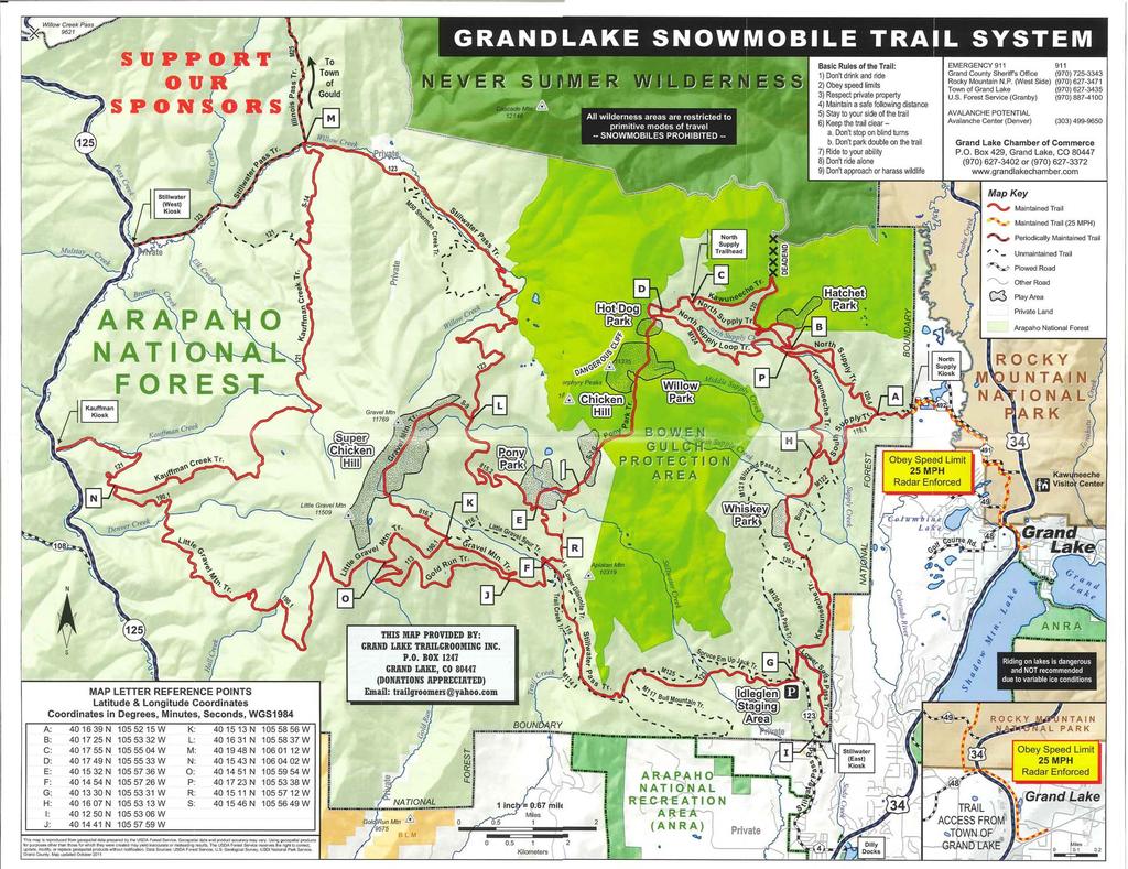
1 Rivers, Trails and Conservation Assistance Program National Park Service U.S. Department of the Interior Application for Community Assistance The National Park Service Rivers, Trails and Conservation Assistance program supports successful partnerships with communities across America in achieving their conservation and outdoor recreation visions. Please follow the application steps on our website and then submit this completed application along with a map of your project site, at least three letters of support, and any other supplementary information that helps us learn more about your project to your National Park Service staff contact by August 1. Date: Aug. 1, 2013 Project Name: NPS Assistance with Pre-Planning a Connector Trail from the Town of Grand Lake, CO to the Arapaho National Forest for Use by Motorized Recreational Vehicles Project Location Description (provide a location/site map): Map attached City and State: Grand Lake, CO Congressional District(s) Number (s): Colorado US Second Congressional District Applicant organization(s): Town of Grand Lake Primary Contact: Joe Biller Title: Town Planner, Town of Grand Lake Street Address:1026 Park Ave. City: Grand Lake State: CO Zip Code: glplanning@townofgrandlake.com Website (if applicable): Daytime Phone: Project Description: 1. Describe: (limit to 750 words total) a) Your vision and project goals; b) Accomplishments to date; c) Support: local, city, regional and state plans, endorsements from elected officials and boards, etc.; d) Community benefits that would result from implementing the proposed project; e) Geographic location of your project (city, watershed, specific areas within a city or county, etc.); f) Important demographic characteristics of your project area. The town of Grand Lake, CO (pop. 471) is situated just south of the west entrance to Rocky Mountain National Park. Its breathtaking lakeside setting ringed on three sides by dramatic mountains has made it a major tourist attraction since the 1880 s, and tourism remains its largest and most critical source of revenue. Grand Lake shares boundaries with Rocky Mountain National Park (RMNP), the Arapaho National Forest (ANF), and the Arapaho National Recreation Area (ANRA) Federal lands. Recreational access from Grand Lake to surrounding Federal lands is a key component of Grand Lake s appeal to its tourist base and is central to its year-round economy. Access to Federal lands from the town itself is abundant by foot or horseback, but due to its cul-de-sac setting, access to Grand Lake by motorized vehicles is limited to a single point at the main entrance road to Grand Lake from Hwy 34. The extensive OHV and snowmobile trail systems in the nearby ANF are separated from Grand Lake by Hwy 34 and by a patchwork of private, public, and Federal land. Supply Creek Trailhead in the ANF is the key access point to these trail systems. It is located northwest of Grand Lake, approximately 2 miles away from the town entrance road. A map of the surrounding area is attached for clarification. At present, there is no motorized access to Supply Creek Trailhead that does not cross RMNP land. A winter snowmobile trail currently runs from the Town entrance, across the SW corner of RMNP, to Supply Creek Trailhead, but this trail is not authorized for OHV use. OHV s must be trailered to Supply Creek via roads that cross RMNP RTCA Application Form
2 The Town of Grand Lake, CO has a long term vision of providing its citizens and visitors with upgraded access directly from the Town to the nearby system of snowmobile trails and OHV roads in the ANF (for example, action items in both the Town of Grand Lake Master Plan and the draft Parks, Open Space, and Trails Master Plan address the construction of a Hwy 34 underpass at the Town entrance for use by multi-modal forms of recreational transportation). The tourism revenue from providing and maintaining this access is projected to be positive, particularly since snowmobiling is virtually the sole source of town tourist revenue in the winter season. Having direct OHV access for the first time would greatly improve our ability to compete with other mountain resort areas for summer OHV tourist business. In the past, snowmobiles were allowed extensive access into and within RMNP during the winter season, and citizens of Grand Lake still recall being able to navigate the entire length of Trail Ridge Road through RMNP to Estes Park by snowmobile. In the 1960 s, Grand Lake became known as the Snowmobile Capital of Colorado and winter tourist business soared as our reputation spread nationwide. However, successive RMNP policy changes over the years have now limited snowmobile access to a single connector trail from Grand Lake town entrance to the Supply Creek Trailhead (see map). The Park section of this trail is managed by RMNP rather than the Grand Lake Trail Groomers Association, a nonprofit organization that manages the rest of the trail. Rather than allowing snow to be brought in, RMNP closes down the trail whenever inadequate snow depth threatens the underlying vegetation, which can be several times per winter season. Snowmobile outfitters cannot count on the connector trail being reliably open for their customers. Moreover, the long standing policy of RMNP absolutely prohibits any OHV traffic inside the park, which eliminates the snowmobile connector trail as a candidate for a direct OHV connector route to Supply Creek Trailhead. All of the above situations have caused a stagnation of tourism in Grand Lake, particularly in the winter season. While other towns and resort areas have been able to expand their recreational vehicle tourist offerings, we have not. We need a fresh look at the possibilities for change, in ways that will benefit recreational users of the ANF motorized vehicle trail systems while preserving the long term conservation policies of RMNP. At the recent 2013 OHV Workshop sponsored by the Colorado Off-Road Vehicle Coalition (COHVCO), it was clear that a common interest in our connector trail project already exists among COHVCO, ANF, GC, the Town, and several private businesses and citizens. At the workshop, a brainstorming session identified the following options for establishment of a connector trail: a) A policy change by RMNP to allow OHV access along the present snowmobile trail route (extremely low probability). b) A land lease from RMNP by GC or the Town of Grand Lake for the connector trail route (very low probability but possibly worth investigating). c) A land swap between the ANF and RMNP to annex the current trail route land to the ANF in exchange for wilderness land farther north on the border between ANF and RMNP (worth investigating). d) Rerouting the current snowmobile connector trail outside the borders of RMNP, along GC and private roads and possibly along an existing GC sewer line easement on the ANF/RMNP border (worth investigating). e) Purchase of private land that abuts the ANF and is accessed by rural roads outside RMNP; building access from this parcel to the OHV trail system via the ANF. This option would require significant funding for land purchase and road construction in the ANF (worth investigating). Although hypothetical and unexplored, the very existence of these options and other as-yet unknown options suggests that a way out of the current impasse is possible. Also pertinent, the Town of Grand Lake and RMNP have jointly won a 2013 grant from the Federal Lands Livability Initiative (FLLI) to have an assessment made of the status of interaction between Grand Lake and surrounding Federal lands. This assessment will take place in September 2013 and will provide feedback about the function of Grand Lake as a gateway community to RMNP, ANF, ANRA, and nearby BLM lands. We anticipate that the assessment will help to clarify the importance of the proposed OHV trail route and will be a valuable tool for the Town in moving the project forward. Realizing our Town goal of a connector trail will be a multi-step and multi-year process, involving many stakeholders. The first step will be to investigate trail options via a dialogue among the stakeholders involved, so that a consensus plan can emerge. We are asking for RTCA assistance in planning a successful approach to this dialogue, including helping us to understand relevant Federal policies and legal options to move our project forward RTCA Application Form
3 2. Describe how your project advances one or more key National Park Service objectives: (limit to 500 words) a. Builds partnerships with health and wellness organizations to promote healthy lifestyles; b. Engages youth or youth organizations to promote close-to-home resource conservation, stewardship, and outdoor recreation opportunities; c. Develops and/or improves connections to parks, rivers, trails, and greenways in diverse urban areas and communities with limited resources and facilities; d. Develops or improves access to National Park Service sites by enhancing connections to nearby communities; e. Advances the protection and stewardship of large natural landscapes (parks, open spaces, and working lands) through partnerships; f. Expands public access to water resources, such as creeks, rivers, lakes, bays, and the coast, and the development of water trails. The Town of Grand Lake believes that our project to explore the possibility of a motorized vehicle connector trail qualifies for RTCA support under categories b) and c) above. 2.b) Snowmobiling and OHV riding are two outdoor sports that have wide appeal to young people, particularly since they can participate without having to be 16 or older. The ANF offers youth over 120 miles of outdoor motorized recreation, but OHV access from Grand Lake requires a valid driver s license and a trailer rig in order to reach the trailhead, as does snowmobile access except for the period(s) in winter when the snowmobile connector trail is open across RMNP. Thus, motorized recreation becomes a function of access to an adult. For many under-16 youth, this is a large negative. Direct trail access for youth would bring them many benefits of constructive outdoor recreation, including the possibility for organized sports groups, and recreational and interpretive youth programs. Indeed, back country OHV trails between Grand Lake and the town of Kremmling at the far end of Grand County could eventually connect the youth of several towns with recreation opportunities. 2.c) As a community of only 471 citizens, Grand Lake has a small tax base and minimal human resources to develop recreational opportunities, both within Town and in surrounding areas. We do not have the advantage of having an alpine ski resort or other major tourist attraction within our town limits to bring in revenue; rather, we rely on secondary revenues from a broad offering of public and private recreation including boating, fishing, hunting, golf, hiking, and winter recreational activities of snowmobiling, snowshoeing, and cross country skiing at the small Nordic center nearby. Adding direct motorized recreational vehicle access to this list is a natural extension of our tourism offerings. A motorized vehicle connector trail between Grand Lake and the ANF Supply Creek Trailhead would directly benefit the Town in the form of increased tourist business and increased recreational opportunities for local residents including youth. It would enhance the ability of the ANF to provide motorized recreation within its boundaries, which is a key component of National Forest policy. A new connector trail route has the potential to free RMNP from the necessity, expense, and ecological consequences of maintaining the current snowmobile connector trail through the Park. And if rural homeowners and other private sector stakeholders are included in the planning process, the new trail may be routed so as to have the least possible negative impact on surrounding areas. Applicant and Partner Roles: (limit to 750 words) 3. a. Describe your role and the level of commitment/services your organization can provide to the project. b. List the key partners involved with the project. Briefly summarize the existing or anticipated role and contribution of each partner. c. Please include three support letters from listed partners other than the applicant or individual(s) of the applying organization that note their support and list their contribution(s) and anticipated project role and responsibilities. 3.a) Role of Applicant The Town of Grand Lake is the applicant and will be the primary administrative body for the project. The principal Grand Lake Team members are: David Hook, Town Manager Joe Biller, Town Planner Scott Krob, Attorney for the Town of Grand Lake Ginny Wilkinson, volunteer for the Town of Grand Lake RTCA Application Form
4 It is anticipated that the principal Team members will devote a minimum of 40 hr/mo to this project, with even more time being available after the end of the summer tourist season. Acting in an advisory role will be: The Hon. Judy Burke, Mayor of Grand Lake An appointee from the Town Council The role of the Grand Lake Team in this project will be to consult with the NPS Assistance Team, to contact stakeholders and arrange regular meetings in-person or by conference call, to research and understand the legal issues surrounding possible options for trail establishment, and to position ourselves for successful application to various funding agencies in the future in order to advance and complete a trail project. We envision that a successful outcome of the RTCA project would be a consensus among stakeholders for a proposed connector trail, and a preliminary plan for moving the trail project through the approval process to final completion. If a successful plan can be formulated, our role will be to apply for financial assistance in the 2014 grant cycle from one or more granting agencies to complete the actual project. Targeted agencies include GOCO, the Colorado Division of Parks and Wildlife, and other public funding sources. Thus, our proposed RTCA project will help us to organize and plan for success in our overall goal. 3.b.) Role of partners and stakeholders Because the connector trail project is in the pre-planning stage, we do not yet have any formal partners. However, we have begun talks with COHVCO, The Grand Lake Trail Groomers Association, and the Colorado Headwaters Trails Alliance (CHTA) that have given us some background information, regulatory information, and grant application assistance. We anticipate that other supporters of this project will be eager to devote time and expertise toward moving it forward, either in an advisory capacity or in direct partnership. We are confident that our list of partners will grow as dialogue progresses and we get our bearings in the planning process. Key stakeholders for the overall project are listed below. Since part of the proposed RTCA project will be to assist us in persuading the relevant stakeholders to come to the table for discussion that leads to partnership, our primary partner for the proposed project will be the NPS RTCA Program itself. We envision that the stakeholder list will include: NPS Alan Ragin, RTCA Program Manager, Hugh Osborne, RTCA technical expert RMNP Larry Gamble, Chief, Branch of Planning and Compliance ANF Dan Matthews, ANRA GC Krisman Guso, Director of Planning and Zoning, Grand County CDOT Mark Rogers, Region 3 Planning Manager COHVCO John Bongiovanni, Co-Chair, COHVCO Scott Jones, Co-Chair of COHVCO and VP of the Colorado Snowmobile Association Colorado Headwaters Trails Alliance (CHTA) Maura McKnight, Director, CHTA Non-profit organizations, including Grand Lake Trail Groomers Association Cameron Stone, Head Groomer Private local businesses and other organizations in and around Grand Lake The role of the various stakeholders/partners will be to participate productively in our dialogue to identify and assess options for establishment of a proposed connector trail route, and ultimately arrive at a consensus for a proposed project plan. 3.c) Letters of Support We attach support letters from the following entities: a) Grand County Commissioners James Newberry, Gary Bumgarner, Merrit Linke b) COHVCO Scott Jones, John Bongiovanni, Co-Chairs c) Grand Lake Trail Groomers Association Cameron Stone, Head Groomer RTCA Application Form
5 Public Support: (limit to 500 words) 4. Describe level of public support to date, and any plans for future public outreach and participation. The level of public support we currently have has been partially described above under Sections 1), 2) and 3) above. In addition, as part of the preparation of the Parks, Open Space, and Trails (POST) Master Plan, the advisory committee conducted a survey of Greater Grand Lake citizens and businesses to gather public information. The survey included over 200 respondents supporting the Town working with the National Park Service and Forest Service on connector trails. As part of their Master Plan, the CHTA has public surveys indicating support throughout Grand County for increased access to motorized vehicle systems. How the National Park Service Could Help: 4. a. What are the biggest challenges and overall needs of the project? (limit to 350 words) The proposed trail project faces significant legal, policy, and procedural challenges in order to go forward. Federal stakeholders have independent policies and procedures regarding trails, recreational access, etc., which are not aligned in a straightforward way. State and local policies and regulations also exist in addition to Federal authority. Private and non-profit entities have long been frustrated by their inability to gain visibility for this project on a Federal level. And finally, any proposed new trail would likely require additional scrutiny of the proposed route to meet whatever CDOT, EPA and other as-yet unexplored requirements may exist. Gaining consensus for an OHV trail project will require addressing all these factors fairly with a view to adapting our project for success. The Town of Grand Lake is willing to spearhead the effort to establish OHV access to the ANF, but we are not currently up to speed on many of the issues. We need to establish key connections to Federal resources that will make our dialogue productive. And we need to understand the Federal, State, and local requirements that need to be met for each of the various route options available before moving forward in the process to establish a new trail. b. What type of assistance are you seeking from National Park Service staff? Please include a short description of the specific project need(s) for each of the boxes checked. (limit to 150 words for each box) Defining project vision and goals X Identifying and analyzing issues and opportunities See below X Assessing and engaging partners and stakeholders See below Inventory and mapping of community resources X Priority setting and consensus building See below Identifying funding sources Organizational development Designing community outreach and participation strategies Planning (trail, park, open space, greenway, etc.) Other Our project would require assistance under the above categories 5.b.b), 5.b.c), and 5.b.e). The Town of Grand Lake is asking for mentoring services from the NPS to help us: a) Understand the background, policy, and procedural issues surrounding the creation of a new OHV/snowmobile trail route across Federal lands. b) Assess the known options for creating the proposed trail and uncover options not yet identified. c) Develop a focused and productive dialogue with trail stakeholders that will lead to a consensus plan to create such a trail. We ask for assistance guiding us through the dialogue process. We believe that the RTCA Program is especially well suited to help us achieve our project goal. Because of its central position within the NPS, your program has access to background information, regulatory information, procedural policies, and key stakeholder contacts, all of which are critical to our project RTCA Application Form
6
7
8
9
10
Preferred Recreation Recommendations Stemilt-Squilchuck Recreation Plan March 2018
 Preferred Recreation Recommendations Stemilt-Squilchuck Recreation Plan March 2018 Below are the recommended recreation ideas and strategies that package together the various recreation concepts compiled
National Park Service Wilderness Action Plan
 National Park Service U.S. Department of the Interior National Park Service Wilderness Action Plan National Wilderness Steering Committee National Park Service "The mountains can be reached in all seasons.
Northern Rockies District Value of Tourism Research Project December 2007
 Northern Rockies District Value of Tourism Research Project December 2007 Project Partners: Northern Rockies Regional District, Tourism British Columbia, Northern Rockies Alaska Highway Tourism Association,
System Group Meeting #1. March 2014
 System Group Meeting #1 March 2014 Meeting #1 Outcomes 1. Understand Your Role 2. List of Revisions to Existing Conditions 3. Information Sources Study Area The Purpose of Mountain Accord is to Preserve
10/25/2013. What is the SCORP?! 2013 Local Government Survey 2013 Statewide Public Survey Advisory Group Priority Areas Your Suggestions!
 COLORADO OUTDOOR RECREATION TRENDS RESULTS FROM THE SCORP AND STATEWIDE Colorado Outdoor Recreation Resource Partnership September 2013 PRESENTATION What is the SCORP?! 2013 Local Government Survey 2013
Committee. Presentation Outline
 CW-33-15 11/9/2015 Community and Corporate Services Committee November 10, 2015 1 Presentation Outline Background Vision and Objectives Study Process and Timeline Public and Stakeholder Engagement Organization
2014 STATEWIDE COMPREHENSIVE OUTDOOR RECREATION PLAN
 2014 STATEWIDE COMPREHENSIVE OUTDOOR RECREATION PLAN SUSTAINING COLORADO S OUTDOOR RECREATION FUTURE SECTION 1: INTRODUCTORY INFORMATION WHAT IS THE SCORP? The SCORP update is required every five years
Restore and implement protected status that is equivalent, or better than what was lost during the mid-1990 s
 THE ROSSLAND RANGE, OLD GLORY AREA. Executive summary. The Friends of the Rossland Range Society, on behalf of the local outdoor community, seeks to accomplish the following with respect to the Old Glory
April 10, Mark Stiles San Juan Public Lands Center Manager 15 Burnett Court Durango, CO Dear Mark,
 Mark Stiles San Juan Public Lands Center Manager 15 Burnett Court Durango, CO 81301 Dear Mark, We are pleased to offer the following comments on the draft San Juan Public Lands Center management plans
JOSLIN FIELD, MAGIC VALLEY REGIONAL AIRPORT DECEMBER 2012
 1. Introduction The Federal Aviation Administration (FAA) recommends that airport master plans be updated every 5 years or as necessary to keep them current. The Master Plan for Joslin Field, Magic Valley
The Chu property is a 6.57 acre parcel located in the Town of Superior on the west side of McCaslin Boulevard. In 2014, the Town of Superior acquired
 1 The Chu property is a 6.57 acre parcel located in the Town of Superior on the west side of McCaslin Boulevard. In 2014, the Town of Superior acquired the Chu property for open space with a contribution
CHAPTER 5. Chapter 5 Recreation Element
 CHAPTER 5 Recreation Element Chapter 5 Recreation Element The Recreation Element of the Meyers Area Plan is a supplement to the Recreation Element of the TRPA Regional Plan and the El Dorado County General
MONTEREY REGIONAL AIRPORT MASTER PLAN TOPICAL QUESTIONS FROM THE PLANNING ADVISORY COMMITTEE AND TOPICAL RESPONSES
 MONTEREY REGIONAL AIRPORT MASTER PLAN TOPICAL QUESTIONS FROM THE PLANNING ADVISORY COMMITTEE AND TOPICAL RESPONSES Recurring topics emerged in some of the comments and questions raised by members of the
Resort Municipality Initiative Annual Report 2015
 Resort Municipality Initiative Annual Report 2015 Submitted by: City of Rossland in association with Tourism Rossland Prepared by: Deanne Steven Acknowledgements The City of Rossland would like to thank
MOREAU LAKE STATE PARK CURRENT PLANNING EFFORTS
 MOREAU LAKE STATE PARK CURRENT PLANNING EFFORTS PLANNING EFFORTS S O U T H E R N PA L M E R T O W N CONSERVATION & ECONOMIC DEVELOPMENT STRATEGY Moreau Lake State Park Master Plan Mt. McGregor Correctional
Methow Trails. Master Plan. Oct
 Methow Trails Master Plan Oct 15 2018 Methow Trails is a 501(c) (3) organization 1.0 INTRODUCTION 2.0 BACKGROUND 2.1 History 2.1.1 Nordic Skiing in the Methow Valley 2.1.2 Connected trail system 2.1.3
Wilds. Headwaters. Lakes. Oxbows. Falls
 56 5 4 3 Wilds Headwaters Lakes Oxbows Falls 57 Zones It could be said the on-the-ground essence of this master plan appears within the next 6 pages of this report. As we learned in the preceding Cultural
Shelf Road Recreation Area 2015 BLM Annual Report of Rocky Mountain Field Institute Stewardship Under BLM Agreement L12AC20483 November 19, 2015
 Summary Shelf Road Recreation Area 2015 BLM Annual Report of Rocky Mountain Field Institute Stewardship Under BLM Agreement L12AC20483 November 19, 2015 Managed by the BLM Royal Gorge Field Office, Shelf
Methow Trails. Master Plan
 Methow Trails Master Plan 11-18-2016 1.0 INTRODUCTION 2.0 BACKGROUND 2.1 History 2.1.1 Nordic Skiing in the Methow Valley 2.1.2 Connected trail system 2.1.3 Funding 2.2 Current Situation 2.2.1 Programs
Rogue River Access and Management Plan Draft Alternatives
 Rogue River Access and Management Plan Draft Alternatives The Rogue River Access and Management Plan was initiated in December, 2011 and is being led by Jackson County Parks (JCP) and Oregon Department
STUDY OVERVIEW MASTER PLAN GOALS AND OBJECTIVES
 INTRODUCTION An Airport Master Plan provides an evalua on of the airport s avia on demand and an overview of the systema c airport development that will best meet those demands. The Master Plan establishes
Village of Taos Ski Valley 2015 Master Plan. Recreation Element
 Village of Taos Ski Valley 2015 Master Plan Taos Ski Valley is known across the world for skiing and winter sports, but the Village has more to offer than advanced skiing terrain and short lift lines.
MUNICIPALITY OF ANCHORAGE
 MUNICIPALITY OF ANCHORAGE ANCHORAGE PARKS & RECREATION Memorandum PRC 08-56 DATE: 5 August 2008 TO: FROM: SUBJECT: Parks & Recreation Commission Holly Spoth-Torres, Park Planner PRC 08-56 Far North Bicentennial
TELEMARK NORDIC 5 YEAR PLAN OCTOBER, 2014
 Page 1 of 6 TELEMARK NORDIC 5 YEAR PLAN OCTOBER, 2014 VISION At Telemark all individuals will be able to follow their passion of cross country skiing, biathlon and snowshoeing in a first class, stimulating
A Master Plan is one of the most important documents that can be prepared by an Airport.
 The Master Plan A Master Plan is one of the most important documents that can be prepared by an Airport. A Master Plan is a visionary and a strategic document detailing planning initiatives for the Airport
Exploring State Water Trail Programs
 National Park Service U.S. Department of the Interior Rivers, Trails, and Conservation Assistance Program Exploring State Water Trail Programs Barbara Nelson- Jameson Corita Waters Jessie Egan E X P E
PROUDLY BRINGING YOU CANADA AT ITS BEST. Management Planning Program NEWSLETTER #1 OCTOBER, 2000
 PROUDLY BRINGING YOU CANADA AT ITS BEST VUNTUT NATIONAL PARK Management Planning Program NEWSLETTER #1 OCTOBER, 2000 INTRODUCTION This newsletter launches the development of the first management plan for
Environment and Natural Resources Trust Fund 2019 Request for Proposals (RFP)
") Environment and Natural Resources Trust Fund 2019 Request for Proposals (RFP) Project Title: Glacial Edge Trail and Downtown Pedestrian Bridge Category: G. Land Acquisition for Habitat and Recreation ENRTF
Environment and Natural Resources Trust Fund 2019 Request for Proposals (RFP) Project Title: Glacial Edge Trail and Downtown Pedestrian Bridge Category: G. Land Acquisition for Habitat and Recreation ENRTF
Environment and Natural Resources Trust Fund 2017 Request for Proposals (RFP)
") Project Title: Total Project Budget: $ Environment and Natural Resources Trust Fund 2017 Request for Proposals (RFP) Floating Classroom: Connecting 20,000 Youth to Minnesota Waterways Category: Proposed
Project Title: Total Project Budget: $ Environment and Natural Resources Trust Fund 2017 Request for Proposals (RFP) Floating Classroom: Connecting 20,000 Youth to Minnesota Waterways Category: Proposed
The Vision for the San Juan Islands Scenic Byway
 The Vision for the San Juan Islands Scenic Byway 2 Judd Cove, Orcas Island, Courtesy of Kurt Thorson (kurtthorson.com) and San Juan County Land Bank Vision for the San Juan Islands Scenic Byway The San
The Future of the Road to Revolutions. A Battle Road Scenic Byway Public Forum November 9, 2010
 The Future of the Road to Revolutions A Battle Road Scenic Byway Public Forum November 9, 2010 Who is the Battle Road Scenic Byway? Four Towns: Arlington, Lexington, Lincoln, Concord Minute Man National
Regional Wayfinding Sign Strategy Thurston County Trails 2017
 Regional Wayfinding Sign Strategy Thurston County Trails 2017 Partners: Members and partnering organizations of the Thurston Thrives Community Design Action Team City of Lacey, City of Olympia, City of
Blue Trails: Protecting Rivers, Fostering Stewardship
 Blue Trails: Protecting Rivers, Fostering Stewardship What Are Blue Trails? Blue Trails are the water equivalent of hiking trails. They are created to facilitate recreation in and along rivers and water
13.1 REGIONAL TOURISM ISSUES AND SUMMARY OF FINDINGS
 13 REGIONAL TOURISM T he County of Mariposa s recreation needs and facilities fall within two categories: regional tourism and local recreation. This Element focuses on regional tourism issues related
ADVENTURE PLAN EXPLORE PARK
 ADVENTURE PLAN ROANOKE COUNTY S EXPLORE PARK ROANOKE COUNTY PARKS, RECREATION AND TOURISM 1206 KESSLER MILL RD SALEM, VA 24153 (540) 387-6078 WHAT S INCLUDED? Explore Park Adventure Plan - Guided by extensive
Crown Corporation Business Plans. Trade Centre Limited
 Crown Corporation Business Plans Trade Centre Limited Contents Message from the CEO and the Chair... 5 Mandate... 7 Alignment with Government s Priorities... 7 Core Responsibilities... 9 Budget Context...
RE: Access Fund Comments on Yosemite National Park Wilderness Stewardship Plan, Preliminary Ideas and Concepts
 September 30, 2016 Superintendent Yosemite National Park Attn: Wilderness Stewardship Plan P.O. Box 577 Yosemite, CA 95389 RE: Access Fund Comments on Yosemite National Park Wilderness Stewardship Plan,
National Capital Mountain Bike Association. Municipal Building Retrofit Program
 National Capital Mountain Bike Association Municipal Building Retrofit Program Our Mission To promote sustainable trail access for Mountain Bike riders, and to maintain the trails on which we ride. We
Gunnison Valley Air Service Strategic Plan. Strategic Priority #1: Creating a Collaborative Public-Private Partnership
 Gunnison Valley Air Service Strategic Plan Strategic Priorities 1. Collaborative Public-Private Partnership 2. Ensuring Stable and Sustainable Funding 3. Air Service Results for the Valley 4. Valley Marketing
WINTER SHELTER IN EAST KING COUNTY
 WINTER SHELTER IN EAST KING COUNTY Vision Statement Every person in East King County has the opportunity to live in a safe, affordable, healthy home. Value Statement Homelessness is an experience that
FINAL TESTIMONY 1 COMMITTEE ON RESOURCES UNITED STATES HOUSE OF REPRESENTATIVES. July 13, 2005 CONCERNING. Motorized Recreational Use of Federal Lands
 FINAL TESTIMONY 1 STATEMENT OF DALE BOSWORTH CHIEF Of the FOREST SERVICE UNITED STATES DEPARTMENT OF AGRICULTURE Before the SUBCOMMITTEE ON FORESTS AND FOREST HEALTH And the SUBCOMMITTEE ON NATIONAL PARKS,
TERMS OF REFERENCE. Drone Advisory Committee (DAC) Role Name or Title Organization. Director, UAS Integration Office. Director, UAS Integration Office
 Role Name or Title Organization. Director, UAS Integration Office. Director, UAS Integration Office") TERMS OF REFERENCE Drone Advisory Committee (DAC) Committee Leadership Role Name or Title Organization Chairman Lead Designated Federal Officer Subcommittee Oversight Oversight Brian Krzanich Administrator
TERMS OF REFERENCE Drone Advisory Committee (DAC) Committee Leadership Role Name or Title Organization Chairman Lead Designated Federal Officer Subcommittee Oversight Oversight Brian Krzanich Administrator
TRAIL USER PERMIT FEE NATURAL RESOURCES, AGRICULTURE AND ENVIRONMENT INTERIM COMMITTEE
 TRAIL USER PERMIT FEE NATURAL RESOURCES, AGRICULTURE AND ENVIRONMENT INTERIM COMMITTEE Chris Haller Off-highway Vehicle Program Manager and Recreation Why? Motorized (Off-highway Vehicle-OHV) community
Infusion of new ideas and energy to continue funding for trails and greenspace
 2012 Summit County Trail & Greenway Plan: Infusion of new ideas and energy to continue funding for trails and greenspace Summit County Trail & Greenway Plan OHIO GREENWAYS History of Trail & Greenway Plan
Strengthening the Ontario Trails Strategy. Report on Consultations and the Environmental Bill of Rights Registry
 Strengthening the Ontario Trails Strategy Report on Consultations and the Environmental Bill of Rights Registry Purpose To report on the feedback and information received through the regional consultations,
RED MOUNTAIN HISTORIC DISTRICT ENHANCEMENT Grand Mesa, Uncompahgre, Gunnison National Forests Ouray Ranger District
 RED MOUNTAIN HISTORIC DISTRICT ENHANCEMENT Grand Mesa, Uncompahgre, Gunnison National Forests Ouray Ranger District Project Summary The Red Mountain President s Initiative Project proposes a comprehensive
MINNESOTA S PARKS & TRAILS LEGACY PROGRAM: ACCOMPLISHMENTS & PROSPECTS
 MINNESOTA S PARKS & TRAILS LEGACY PROGRAM: ACCOMPLISHMENTS & PROSPECTS PAU L P U R M A N M I N N E S OTA D E PA R T M E N T O F N AT U R A L R E S O U R C E S, PA R K S & T R A I L S L EG 5/15/2016 1 A
A CASE FOR COMPLETING THE JORDAN RIVER PARKWAY: A
 A CASE FOR COMPLETING THE JORDAN RIVER PARKWAY: A safe crossing at 9000 South and 850 West Proposed 9000 South Underpass Parkway Timeline Parkway, Trail, and Tourism Facts Blueprint Jordan River 1971 1973
BACKCOUNTRY TRAIL FLOOD REHABILITATION PROGRAM
 BACKCOUNTRY TRAIL FLOOD REHABILITATION PROGRAM Backcountry Trail Flood Rehabilitation A June 2013 Flood Recovery Program Summary In June 2013, parts of Southern Alberta were devastated from significant
!" # $ % & % ' ( '' ) ) ) ) )
 ) ) ) )") !" #$% &% ' ( ')) ))) #% * % ) +#% *- *,% ) Trails Attract Business, Residents and Tourists National Association of Homebuilders 0% 20% 40% 60% % of What People Desired Exercise Facilities Proximity to
!" #$% &% ' ( ')) ))) #% * % ) +#% *- *,% ) Trails Attract Business, Residents and Tourists National Association of Homebuilders 0% 20% 40% 60% % of What People Desired Exercise Facilities Proximity to
ACRP 01-32, Update Report 16: Guidebook for Managing Small Airports Industry Survey
 ACRP 01-32, Update Report 16: Guidebook for Managing Small Airports Industry Survey Goal of Industry Survey While there are common challenges among small airports, each airport is unique, as are their
National Wilderness Steering Committee
 National Wilderness Steering Committee Guidance White Paper Number 1 Issue: Cultural Resources and Wilderness Date: November 30, 2002 Introduction to the Issue Two of the purposes of the National Wilderness
Steps in the Management Planning Process
 Steps in the Management Planning Process Developing a management plan for Kalamalka Lake Park will follow a multi-stage process. The planning process for this park is currently in the Draft Management
DRAFT - APRIL 13, 2007 ROUTING STUDY FOR TRAIL CONNECTIONS BETWEEN CALAIS AND AYERS JUNCTION
 DRAFT - APRIL 13, 2007 ROUTING STUDY FOR TRAIL CONNECTIONS BETWEEN CALAIS AND AYERS JUNCTION Abstract The vision for the East Coast Greenway is an off-road urban trail system running from Calais, Maine
Proposed Action. Payette National Forest Over-Snow Grooming in Valley, Adams and Idaho Counties. United States Department of Agriculture
 United States Department of Agriculture Forest Service January 2012 Proposed Action Payette National Forest Over-Snow Grooming in Valley, Adams and Idaho Counties Payette National Forest Valley, Adams
Sawtooth National Forest Fairfield Ranger District
 United States Department of Agriculture Forest Service Sawtooth National Forest Fairfield Ranger District P.O. Box 189 Fairfield, ID. 83327 208-764-3202 Fax: 208-764-3211 File Code: 1950/7700 Date: December
National Scenic Byways Program US Department of Transportation
 1 2 National Scenic Byways Program US Department of Transportation Abstract The Cowlitz-Wahkiakum Council of Governments in partnership with Cowlitz, Skamania and Lewis Counties and the U.S. Forest Service,
White Mountain National Forest Saco Ranger District
 United States Department of Agriculture Forest Service White Mountain National Forest 33 Kancamagus Highway Conway, NH 03818 Comm: (603) 447-5448 TTY: (603) 447-3121 File Code: 1950 Date: February 26,
Land Management Summary
 photo credit: ANGAIR Anglesea Heath Land Management Summary The Anglesea Heath (6,501 ha) was incorporated into the Great Otway National Park in January 2018. This provides an opportunity to consider the
Blueways: Rivers, lakes, or streams with public access for recreation that includes fishing, nature observation, and opportunities for boating.
 Parks, Open Space and Trails PRINCE WILLIAM COUNTY 2008 COMPREHENSIVE PLAN TRAILS PLAN CONTENTS The components of the trails plan are: Intent Definitions Goals, Policies, and Action Strategies Trails Map
POLICE AND FIRE & RESCUE SCRUTINY SUB-COMMITTEE. Consultation, Annual Review of Policing 2017/18 by Scottish Police Authority (SPA)
") To: POLICE AND FIRE & RESCUE SCRUTINY SUB-COMMITTEE On: 22 MAY 2018 Report by: DIRECTOR OF ENVIRONMENT & COMMUNITIES Heading: Consultation, Annual Review of Policing 2017/18 by Scottish Police Authority
To: POLICE AND FIRE & RESCUE SCRUTINY SUB-COMMITTEE On: 22 MAY 2018 Report by: DIRECTOR OF ENVIRONMENT & COMMUNITIES Heading: Consultation, Annual Review of Policing 2017/18 by Scottish Police Authority
Worksheet: Resolving Trail Use(r) Conflict March 27, 2010
 Conflict March 27, 2010") RI Land & Water Summit Worksheet: Resolving Trail Use(r) Conflict March 27, 2010 John Monroe National Park Service, Rivers & Trails Program 617 223 5049 John_Monroe@nps.gov www.nps.gov/rtca In one sentence,
RI Land & Water Summit Worksheet: Resolving Trail Use(r) Conflict March 27, 2010 John Monroe National Park Service, Rivers & Trails Program 617 223 5049 John_Monroe@nps.gov www.nps.gov/rtca In one sentence,
Section II. Planning & Public Process Planning for the Baker/Carver Regional Trail began in 2010 as a City of Minnetrista initiative.
 Section II Planning & Public Process Planning for the began in 2010 as a City of initiative. city staff began discussions with the Park District on the possibility of a north/south regional trail connection
Part 1: Introduction to Decision Making
 Part 1: Introduction to Decision Making 1.1 - Anatomy of a Decision ABOUT AIARE Learning Outcomes Identify that backcountry decision making involves five key components: Plan, Observe, Teamwork, Choose
Federal Outdoor Recreation Trends Effects on Economic Opportunities
 United States Department of Agriculture Federal Outdoor Recreation Trends Effects on Economic Opportunities The Forest Service National Center for Natural Resources Economic Research is assisting the Federal
Establishing a National Urban Park in the Rouge Valley
 STAFF REPORT ACTION REQUIRED Establishing a National Urban Park in the Rouge Valley Date: March 29, 2012 To: From: Wards: Reference Number: Executive Committee Deputy City Manager, Cluster B All p:\2012\cluster
Rethink Vancouver. Tourism Industry Summit. March 31, 2011
 Rethink Vancouver Tourism Industry Summit March 31, 2011 SUMMIT INTRODUCTION James Terry, Chairman Rethink Vancouver Advisory Council SIX QUESTIONS FOR TODAY S DISCUSSION 1. Should there be a larger shared
PERTH AND KINROSS COUNCIL. Housing and Health Committee. 25 May Perth and Kinross Local Housing Strategy
 PERTH AND KINROSS COUNCIL 7 16/234 Housing and Health Committee 25 May 2016 Perth and Kinross Local Housing Strategy 2016-2021 Report by Director (Housing and Social Work) PURPOSE OF REPORT This report
Appalachian Trail Community
 Harpers Ferry, West Virginia Appalachian Trail Community A Designation Program of the Appalachian Trail Conservancy The Appalachian Trail Conservancy (ATC) mission is to preserve and manage the Appalachian
Green Mountain Trail Collaborative Stewardship and Communication Work Group Meeting Notes June 30, 2010
 Date: 6-30-10 Time: 12:30-1:30 Location: Phone Conference Facilitator: Brian D. Cotterill Note Taker: Brian D. Cotterill Committee Members in Attendance: Danny Hale Doug Webber Sherry Winnie Alexis Nelson
Sustainable Tourism Strategy for Southern Africa
 RETOSA s Sustainable Tourism Strategy for Southern Africa Presentation by: Kwakye Donkor, Marketing and Communications Director At Sustainable Tourism Certification Alliance Africa 2013 2 nd Annual Conference
Rouge Park Trail and Park Volunteers Orientation Package
 Rouge Park Trail and Park Volunteers Orientation Package In this package you will find: Welcome! Introduction to Rouge Park Introduction to the HAVE Program The Guided Walks and Ambassadors programs; part
Submission to. Southland District Council on. Draft Stewart Island/Rakiura Visitor Levy Policy and Bylaw
 Submission to Southland District Council on Draft Stewart Island/Rakiura Visitor Levy Policy and Bylaw Date: 9 November 2018 Tourism Industry Aotearoa (TIA) welcomes the opportunity to comment on Southland
Final Recreation Report. Sunflower Allotment Grazing Analysis. July 2015
 Final Recreation Report Sunflower Allotment Grazing Analysis July 2015 Table of Contents Introduction... 3 Affected Environment... 3 Four Peaks Wilderness Area... 3 Dispersed Recreation... 3 Environmental
Instructions: Script:
 Before the course, select four of the 11 tool topics to insert into the presentation, including at least one tool from each of the three goal categories. Replace each tool placeholder slide with the slides
ASSEMBLY 39TH SESSION
 International Civil Aviation Organization WORKING PAPER 22/6/16 ASSEMBLY 39TH SESSION EXECUTIVE COMMITTEE Agenda Item 31: Other high-level policy issues to be considered by the Executive Committee THE
FINAL PROJECT COMPLETION REPORT
 FINAL PROJECT COMPLETION REPORT I. BASIC DATA Organization Name: Wildaid Project Title: Assessment and Strategy for Protecting Wildlife and Timber Resources in the Gunung Leuser Ecosystem II. OPENING REMARKS
The Utah Trails Initiative: Partnerships, Research, and Action
 The Utah Trails Initiative: Partnerships, Research, and Action Steven W. Burr Dale J. Blahna Douglas K. Reiter Michael Butkus 1 Introduction As a result of changing social values regarding the development
Chapter 6: POLICY AND PROCEDURE RECOMMENDATIONS
 Chapter 6 POLICY AND PROCEDURE RECOMMENDATIONS FOR SRRA Below are seven policy elements that should be considered for adoption by the Southwest Regional Recreation Authority of Virginia: 1. Develop strategies
AIRPORT SPONSORSHIP POLICY
 AIRPORT SPONSORSHIP POLICY The Muskegon County Airport (MKG) Sponsorship policy (Policy) is intended to ensure Airport sponsorships are coordinated and aligned with its business goals, maximize opportunity
Thaidene Nëné Proposed National Park Reserve. Public Consultation in Yellowknife, NWT June 2016 Protected Areas Establishment Branch Parks Canada 1
 Thaidene Nëné Proposed National Park Reserve Public Consultation in Yellowknife, NWT June 2016 Protected Areas Establishment Branch Parks Canada 1 Consultations for Thaidene Nëné Purpose Parks Canada is
Strategic Plan. Manassas Battlefield Trust
 Manassas Battlefield Trust m Strategic Plan 2018-2020 M a n a s s a s B a t t l e f i e l d T r u s t, 1 2 5 2 1 L e e H i g h w a y, M a n a s s a s, V A 2 0 1 0 9 Manassas Battlefield Trust Manassas,
PROPOSAL FOR RECLASSIFICATION, BOUNDARY AMENDMENT AND DRAFT CONCEPT PLAN FOR SASKATOON MOUNTAIN NATURAL AREA. Frequently Asked Questions
 PROPOSAL FOR RECLASSIFICATION, BOUNDARY AMENDMENT AND DRAFT CONCEPT PLAN FOR SASKATOON MOUNTAIN NATURAL AREA 1. Why is this proposal being put forward? Frequently Asked Questions For many years, Alberta
A Proposed Framework for the Development of Joint Cooperation On Nature Conservation and Sustainable Tourism At World Heritage Natural sites.
 Introduction: A Proposed Framework for the Development of Joint Cooperation On Nature Conservation and Sustainable Tourism At World Heritage Natural sites Between The tourism industry and the UNESCO, World
LEBANON: A DIVERSE ECOTOURISM DESTINATION IN THE EAST-MEDITERRANEAN. Prepared by: Dr. Jacques Samoury NGER National Expert
 National Stakeholder Workshop on Ecotourism 6-7 March 2018, Beirut LEBANON: A DIVERSE ECOTOURISM DESTINATION IN THE EAST-MEDITERRANEAN Prepared by: Dr. Jacques Samoury NGER National Expert Lebanon s Tourism
Wanaka Community Board 15 April Report for Agenda Item: 4
 Wanaka Community Board 15 April 2015 Department: Infrastructure Report for Agenda Item: 4 Mt Burke Station Stopping and Vesting of Road Purpose 1 To obtain the Board s support for a stakeholder agreement
Port Gamble Shoreline Area Conceptual Trail Proposal
 The North Kitsap Trails Association is pleased to be a partner to the Kitsap Forest and Bay Project and assist Kitsap County, Forterra, Olympic Property Group, Great Peninsula Conservancy and the Port
HOW TO OPERATE A PRODUCT DEVELOPMENT FAMILIARIZATION TOUR MANUAL FINAL REPORT FOR DEPARTMENT OF TOURISM & CULTURE
 HOW TO OPERATE A PRODUCT DEVELOPMENT FAMILIARIZATION TOUR MANUAL FINAL REPORT FOR DEPARTMENT OF TOURISM & CULTURE August 2008 1.0 PROJECTAPPLICANT Kluane Inc. Geordan Clark, General Manager Box 20, Burwash
To: Cam Hooley From: Trails 2000 Date: September 30, 2016 Re: Hermosa Comments. Dear Cam:
 ! To: Cam Hooley From: Trails 2000 Date: September 30, 2016 Re: Hermosa Comments Dear Cam: Trails 2000 is commenting on the Forest Service Management Plan for the Hermosa Creek Watershed Management Plan
TURTLE SURVIVAL ALLIANCE EXECUTIVE DIRECTOR
 Transforming passion for turtles into effective conservation action through a global network of living collections and recovery programs. TURTLE SURVIVAL ALLIANCE BACKGROUND TURTLE SURVIVAL ALLIANCE EXECUTIVE
CHAPTER 1: INTRODUCTION
 CHAPTER 1: INTRODUCTION Purpose and Scope The information presented in this report represents the study findings for the 2016 Ronan Airport Master Plan prepared for the City of Ronan and Lake County, the
(This page intentionally left blank.)
") Executive Summary (This page intentionally left blank.) Executive Summary INTRODUCTION The Cache Valley Transit District (CVTD) contracted with the team of Transportation Consultants, Inc. () and Fehr
Executive Summary (This page intentionally left blank.) Executive Summary INTRODUCTION The Cache Valley Transit District (CVTD) contracted with the team of Transportation Consultants, Inc. () and Fehr
SAN BERNARDINO INTERNATIONAL AIRPORT AUTHORITY (SBIAA) Annual Evaluation and Review - Strategic Plan December 16, December 21, 2016
 Annual Evaluation and Review - Strategic Plan December 16, December 21, 2016") SAN BERNARDINO INTERNATIONAL AIRPORT AUTHORITY (SBIAA) Annual Evaluation and Review - Strategic Plan December 16, 2015 - December 21, 2016 Background Norton Air Force Base (Norton AFB) was originally constructed
SAN BERNARDINO INTERNATIONAL AIRPORT AUTHORITY (SBIAA) Annual Evaluation and Review - Strategic Plan December 16, 2015 - December 21, 2016 Background Norton Air Force Base (Norton AFB) was originally constructed
LESSON 9 Recognizing Recreational Benefits of Wilderness
 LESSON 9 Recognizing Recreational Benefits of Wilderness Objectives: Students will: study, analyze, and compare recreation visitor days (RVD s) for Wilderness areas adjacent to their homes or nearest state,
MRO 2017 Stakeholder Survey
 MRO 2017 Stakeholder Survey Summary Results Conducted in October 2017 MIDWEST RELIABILITY ORGANIZATION 380 St. Peter Street, Ste.800 St. Paul, MN 55102 P: 651.855.1760 F: 651.855.1712 www.midwestreliability.org
OREGON TOURISM LISTENING SESSION SUM M ARY
 OREGON TOURISM LISTENING SESSION SUM M ARY June 2018 T O U R I S M L I S T E N I N G S E S S I O N O V E R V I E W Travel Oregon, in partnership with the Central Oregon Visitors Association, hosted an
TAYLOR CANYON RANCH COLORADO - ROUTT COUNTY - STEAMBOAT SPRINGS
 TAYLOR CANYON RANCH COLORADO - ROUTT COUNTY - STEAMBOAT SPRINGS Tucked up against the steep valley shaped by Mt. Pau and rising to the Routt National Forest, Taylor Canyon Ranch is an easily accessible,
PERTH AND KINROSS COUNCIL. Enterprise and Infrastructure Committee 4 November 2009
 PERTH AND KINROSS COUNCIL 4 09/494 Enterprise and Infrastructure Committee 4 November 2009 STRATEGIC PRIORITIES FOR TOURISM AND AREA TOURISM PARTNERSHIP ARRANGEMENTS Report by Depute Director (Environment)
Kit Carson-Challenger Ridge Trail Project
 Kit Carson-Challenger Ridge Trail Project Project Accomplishments Report-USFS December 15, 2015 Photo courtesy of Justin Peterson 815 South 25 th Street, Suite 101 Colorado Springs, CO 80904 Dedicated
The Airport. p a g e 2
 The Airport Telluride Regional Airport (TEX) with a runway altitude of 9,070 feet MSL is the highest airport in North America with commercial service in light of the fact that, after a two-year hiatus,