CITY OF ORR TRANSPORTATION IMPROVEMENT PLAN JUNE Prepared by: Arrowhead Regional Development Commission Regional Planning Division
|
|
|
- Sharlene Reeves
- 5 years ago
- Views:
Transcription


1 CITY OF ORR TRANSPORTATION IMPROVEMENT PLAN JUNE 2012 Prepared by: Arrowhead Regional Development Commission Regional Planning Division

2 City of Orr Transportation Improvement Plan 2012 Prepared for the City of Orr Prepared by Arrowhead Regional Development Commission Regional Planning Division
3 Table of Contents Introduction... 1 Transportation System... 3 Recommended Projects... 8 Implementation Strategy State and Federal Transportation Programs Appendix A City of Orr Infrastructure Maps Appendix Map 1 City of Orr Infrastructure South Map 2 City of Orr Infrastructure Downtown Map 3 City of Orr Infrastructure North Map 4 City of Orr Infrastructure Moose Lake Hill Area i
4 INTRODUCTION The following is the City of Orr s Transportation Improvement Plan. The development of this plan and other transportation related initiatives were recommended in the City s recently completed comprehensive plan, which was facilitated by Arrowhead Regional Development Commission (ARDC) and adopted by the Orr City Council on October 11, Following the adoption of the Comprehensive Plan, the City continued to work with ARDC on implementing recommendations from the comprehensive plan. In the Summer of 2011, the City was awarded a grant from the Regional Transportation Advisory Committee (RTAC) to receive technical assistance from ARDC to advance the transportation action steps from the comprehensive plan. Key elements of the recommended action steps addressed by this RTAC grant include: 1) Design and construct a paved, non-motorized trail that connects the City Hall, Tourist Information Center, and Bog Walk, as well as the City Park and Beach, to downtown Orr and the Pelican Lake public access, 2) Hold an annual transportation review in Orr that includes St. Louis County and Mn/DOT maintenance staff and other pertinent personnel, and 3) Develop a five year transportation investment plan that lists needed projects. This document primarily focuses on the five year transportation investment plan to address improvements and concerns within the City s transportation facility. Background The City of Orr has continued to undergo some major community changes, yet has remained positive with its many assets and opportunities within the community. In 2011, the St. Louis County School District closed the Orr K-12 school. Students now attend school in a newly constructed building approximately five miles north of Cook. To this date, the Orr School Site has not been sold or redeveloped. Orr s grocery store was closed in much of 2010 and 2011, it has since reopened under new management as Pelican Lake Foods. The Gateway Lodge and Suites, once Orr s largest employer, closed in late October, 2011, and has reopened as Oveson s Pelican Lake Resort & Inn. The City has continued to work diligently to attract new businesses to the community and feels that implementing its transportation action steps is an important step to reaching the goals of the community. 1

5 Community Profile Orr is a city in St. Louis County, Minnesota. It is located on Pelican Lake, a large natural lake (11,500 acres) that has many cabins, homes, and resorts on its shores. The City is served by Highway 53. Pelican Lake is a popular recreational lake that is known for its panfish, bass, northern pike, and walleye fishing. U.S. Highway 53 serves as a main arterial route in the city. A CN railroad line (formerly the Duluth, Winnipeg, and Pacific line) also runs through the City. The City has a total area of 1.4 square miles. The elevation is 1,306 feet above sea level. The Pelican Lake area was originally inhabited by native people, including the Dakota and most recently the Ojibwe (Chippewa). The Bois Forte Band of Chippewa currently has a reservation community located at Nett Lake, just west of Orr. In the 1800 s the Orr area was part of the region that was being used for the fur trade, which led to the first explorations by Europeans. By the early 1900 s logging of the area s pine trees brought additional settlers to Orr. A post office was established in 1907; William Orr was the postmaster and owner of a general store. 1 In 1908 construction of a railroad connecting Virginia, Minnesota to International Falls, Minnesota brought a new connectivity to the community. From the Virginia and Rainy Lake Lumber Company headquartered in Cusson (just to the north of Orr) and supplied logs to a sawmill in Virginia. During that time period, the Virginia Rainy Lake and Company had more than 16 camps of more than 200 men in each throughout the area. Moonshine shacks eventually became popular in the area and created violence that was said to be unparalleled. There were many reports of missing people and state intervention was eventually needed to bring order back to the area. With no local police, 1928 led to citizens forming a committee to clean the community of criminal activities. Measures were eventually taken and Orr was incorporated, which allowed it to have its own police. Orr was incorporated as a village on June 7, The violence of the early timber years was soon reduced and businesses were able to diversify. 2 1 From: 2 Small Town of Orr Has a Wild and Colorful Past by Mary Lou Pearson, Historian, Voyageurs National Park. 2
6 TRANSPORTATION SYSTEM Background The transportation system through and near Orr relies heavily on two transportation corridors, Highway 53 and County Highway 23. Orr is within the St. Louis County Public Works Maintenance District Four, which covers the northern portion of the county. Encompassing an area of 2,700 miles, this district maintains approximately 904 miles of roads. Orr is also located within the Minnesota Department of Transportation (MnDOT) District One. MnDOT District One is headquarters is located in Duluth with an additional office in Virginia. District One serves the eight counties of northeastern Minnesota, which encompasses approximately 1,600 miles of roadway and one-fourth of the state s total land area. District One s top priority is to preserve the existing transportation system. Their construction program emphasizes pavement replacement, drainage improvements, intersection upgrades, and bridge rehabilitation and replacement. Highway 53 Trunk Highway 53, administered by MnDOT, is a very important asset to the region, state and nation as it serves as a major trade route by efficiently transporting people and goods north and south. In 1975, activity related to expanding TH 53 to four lanes between Virginia and International Falls with the creation of Voyageurs National Park on the northern edge of Minnesota. Based on the initial estimated visitor projections for the park, an Environmental Impact Statement (EIS) was begun and completed through the Draft EIS stage for highway expansion. The EIS work ended in 1980 when it became apparent that funding for the project would not be available and that the visitor projections for Voyageurs National Park were overly optimistic. In April 1998, the Trunk Highway 53 Long Range Improvement Task Force was formed of citizens, local government officials, business and industry representatives and the Minnesota State Patrol. The stated mission of the task force was to insure a safe and modern four lane roadway for all users on TH 53 between Virginia and International Falls. The diligence and efforts of the task force, with the assistance of Minnesota Congressman James Oberstar, resulted in Highway 53 from International Falls, Minnesota to Chippewa Falls, Wisconsin being designated the Falls to the Falls High Priority Trade Corridor; Congressional High Priority Corridor #41; in the Federal Transportation Equity Act (TEA-21) enacted in The designation as a high priority trade corridor made it eligible for funding under the National Corridor Planning and Development (NCPD) Program. 3

7 Currently, the last planned expansion of four lanes to Highway 53 will be from Virginia to the south city limits of Cook. The project will be completed in two stages, stage one was completed in 2009 and ended at approximately County Road 652. Construction of the second stage is scheduled to begin in October 2012 with completion in August See the map to the right for the location of the final expansion project. CSAH 23 (Nett Lake Road) Highway 23 West begins south of Orr at the corner of the Dam Restaurant. It is approximately 18 miles and a 20 minute drive from Highway 53 to the community of Nett Lake. CSAH 23 (Orr- Buyck Road) Highway 23 East begins in downtown Orr and extends to Buyck. This 16 mile trip takes approximately 30 minutes to drive. CSAH 23 ends in Buyck where it connects to CSAH 24 (Crane Lake Road). The community of Crane Lake is approximately 10 miles north of Buyck, approximately a 25 minute drive on Crane Lake Road. Transportation within the City Transportation within the City for residents and visitors also relies on a network of local roads. Lake Street, administered by St. Louis County, runs parallel to Hwy 53 on the east side of the railroad tracks and is an important connection within the community. Two multi-family apartment buildings are located on this road, Kallio and Bay View, which also hosts many residential houses. Johnson Parkway is located behind the primary business district in Orr. The southern terminus of the road is between Norman s One Stop and the Muni Store and the northern terminus is on the north side of T-Pattenn Café. This road serves as a valuable thoroughfare to the public water access and businesses in the area. Map to right shows the Average Daily Traffic Volumes within the City. In red, Trunk Hwy Routes (2006). In Blue, County System (2007). 4
8 Gheen Hill Trails The Gheen Hill Trails are part of a multi-use system that is open to cross country skiers, hikers, mountain bikers, and hunters. There are many opportunities for viewing birds and other wildlife along the 4.5 miles of trails that wind through aspen, birch and pine stands. The trails are groomed and tracked in the winter with marked intersections. There are three parking locations to enter the trails. The main parking location is on the north side of the trail, approximately four miles south of Orr. This area can hold around ten or more vehicles. The other locations are at the top of the hill, approximately one mile further south and is utilized by fire and utility towers. This area also features many parking options. This system is a Grant-in-aid trail, which is cooperatively managed by the City of Orr and its residents, the Minnesota Department of Natural Resources, and the Ruffed Grouse Society. A state permit is necessary for use of this trail. Orr Regional Airport The Orr Regional Airport is located on the south west side of the City on County Road 23 (Nett Lake Road). The airport is managed by the City and features a 4,001 by 75 foot runway, no landing fee, hangers, 24 hour available fuel with credit card, and an attendance schedule of seven days a week from 9 a.m. to 4 p.m. The Airport has recently undergone some major renovations including repaving the runway and taxiway, as well as rehabilitating the parking lot and entryway. The pavement rehabilitation was presented the Project of the Year by the Minnesota Council of Airports for intermediate airports. The project was chosen because of the safety improvements, minimal impact on the ecosystem and because it was completed on time and within budget. The project also received the Minnesota Department of Transportation s Merit Award at the 2011 Minnesota Asphalt Paving Association s award banquet. 5

9 Lake Vermilion Trail The Lake Vermilion Trail Plan was developed in 2011 in an effort to add to the future recreational and economic assets of the area and continue to connect people to the beauty of the region. The Trail Plan outlines a general 39 mile alignment for a proposed paved trail connection between the cities of Cook and Tower, providing an alternative on/off road transportation route that connects people to a scenic beauty of the south shore area of Lake Vermilion. The plan also covers opportunities for trailhead facilities, interpretive sites, recreational amenities, as well as local and regional promotion for tourism. The plan is intended to be used as a tool for guiding near term development of the first phases of the project and outlining for longer term phases of the project. Work is continuing on the development of this trail system, including trail alignments. The Trail Plan included considerations for future connections to Orr. Mesabi Trail The Mesabi Trail is a northern Minnesota bike trail that runs through some of the states most distinct, beautiful and treacherous areas. The trail is partially built on old railroad beds and has a 10 foot wide bituminous surface. The trail offers many attractions throughout include campgrounds, local parks, and nearby community amenities. The trail is near completion and upon completion; will be 132 miles and connect 25 communities between Grand Rapids and Ely, to Orr s south. Voyageur Snowmobile Trail System The Voyageur Snowmobile Trail System is located in and around Voyageurs National Park. Orr is located in the southeast section of the trail system, which incudes the communities of Buyck, Crane Lake and Orr, which is host of the Voyageurs National Park Area Information Center and serves as trail head parking for the trail system. Canadian National Railroad The Canadian National (Duluth, Winnipeg, & Pacific) Railroad has a major line through Orr. Train speeds through the City are 30 mph per a City of Orr Resolution. The Minnesota Department of Transportation estimated 17 trains traveling through the City per day in This track connects the Duluth/Superior transportation hub with the Canadian Border near International Falls. 6


10 Arrowhead Transit Arrowhead Transit has been a public transportation service since It was originally created to provide low-cost transportation for poor, disabled and elderly. It now has nearly 70 routes in and around the arrowhead region and is the largest rural public transportation system in the U.S. All of Arrowhead Transit s busses are handicap accessible and their drivers undergo extensive training. There are no age or income guidelines for using this service. All services provided in Orr require trip reservations by contacting Arrowhead Transit and each route must have five passengers to go. Schedule and fare information can be found below. Orr and Cook to Virginia/Duluth 2nd Friday of the month 7:40 a.m. Orr pick-ups 8:05 a.m. Cook pick-ups 8:30 a.m. Arrive Virginia 10:00 a.m. Arrive Duluth 10:00 a.m. Shuttle to clinic/hospital 1:30 p.m. Shuttle back to mall 2:00 p.m. Leave Duluth Bois Forte Public Transit Service Transportation to Virginia Every Thursday 8:15 a.m. Nett Lake 8:30 a.m. Orr 9:00 a.m. Cook 9:20 a.m. Idington 9:50 a.m. Arrive Virginia 2:00 p.m. Return from Thunderbird Mall 2:05 p.m. Return from Super One One Way Fares Orr to Cook $2.40 Orr to Duluth $8.60 Orr to Virginia $2.70 The new Bois Forte Transit Service has been operating on a trial basis between Vermilion and Virginia. This service is offered to anyone in the region with a.m. and p.m. routes Monday through Friday. The cost is $3 per ride or 10 rides for $25. Currently, the primary duty of this service is to provide individuals a route from Virginia to Fortune Bay. Bois Forte recently completed a new transit plan and has hired a transportation coordinator to help residents get to their necessary destinations. 7
11 Recommended Projects The City of Orr staff worked to assist ARDC identify the following projects. The City and ARDC used community input that was developed during the comprehensive planning process to determine the most important projects in the City. Below is a summary of the fifteen projects identified to improve the transportation facility within the City. Project analysis and details are found on the following pages. 1 Enhance the North Parking Area 2 Develop a Public Marina 3 Enhance Community Signage 4 Develop a Community Trail 5 Develop a Natural Surface (Mountain Bike) Trail 6- Work to control speed within the Hwy 53 Corridor in the City 7- Sustain the Orr Regional Airport 8- Ensure proper lighting above all transportation facilities within the community 9 Complete maintenance to the Bog Walk 10 Improve parking in the downtown and highway business corridor 11 Include aesthetically pleasing features to the transportation facility within the City 12 Make necessary improvements to City Infrastructure on Highway 23 during reconditioning project 13 Upgrade sewage and water pipes from 4 to 6 inch in the City. Collaborate with road jurisdiction to ensure project conjunction 14 Increase sidewalk facilities throughout the community 15 Explore potential for a Pelican Lake Trail 8


12 1.0 Enhance the North Parking Area Orr s paved lot along Highway 53 is located on the east side of the highway. It is situated just north of the County Road 23 intersection and abuts the Rail line. This area has a narrow and steep access and exit. This area has been determined underutilized and design improvements are sought in this area. 1.1 Convey the importance of this area while planning to make updates to the downtown Notify MnDOT of the spring in this area and encourage the installation of drain tile. This will allow City maintenance staff to mow the grass in this area. 1.3 Include signage to the area to make visitors aware of the vehicle/trailer parking opportunity. 2.0 Develop a Public Marina The community would like to add some minimal marina facilities to the DNR boat launch area. This area could be enhanced with some additional docks for mooring boats to allow boaters to shop, eat, or use other community services. This site could also serve as a community focal point. This could be accomplished through kiosks that provide historical information about the community, traveler information, and tell the story of the Bois Forte Band of Ojibwe to promote its facilities. 2.1 Work with the DNR to determine what types of updates could happen in this area. 2.2 Include this area while planning to make updates to the downtown. 9


13 3.0 Enhance Community Signage Orr would like to see more signage in the community that directs travelers and highlights its features. This enhanced signage could be themed and could feature other nearby destinations that Orr serves, including Pelican Lake Resorts, Nett Lake, Voyageurs National Park, the Boundary Waters Canoe Area, Crane Lake, and the Ash River Laboratory. 3.1 Work with a design team to create designs for a City Entrance Sign. 3.2 Work with a design team to create navigational signs for local and area attractions Enhance signage to the entrance of the Gheen Hill Trails. 10
14 4.0 Develop a Community Trail Orr would like to develop a paved, non-motorized trail from the City Hall on the South end of Orr to the Pelican Lake Lodge on the North end. This 1.3 mile long trail would access nearly all of the existing features of the City. 4.1 Determine the alignment of the trail in a design process with local resident, business owner, and engineer support. Trail construction approximate cost: $292,500. This price is based on construction cost of $225,000/ mile estimate and does not include engineering costs or right of way acquisition. 5.0 Develop a Natural Surface (Mountain Bike) Trail Orr envisions a mountain bike trail from the terminus of the proposed City trail that travels south to the Gheen Hill trail system, which is four miles away, and eventually to Cook and its amenities, including the North Woods School and the proposed Lake Vermilion Trail. The City believes the trail would be a great amenity. Mountain Bike facilities and parks are rapidly increasing in popularity. The Gheen Hill is a gravel facility that might lend itself well to mountain bikes. Construction and maintenance costs for mountain bike facilities varies greatly upon each facility. 5.1 Work with an experienced Mountain Bike facility developer to determine the feasibility of a trail at the Gheen Hill. 11
15 6.0 Work to control speed within the Hwy 53 Corridor in the City Speeding through Orr on Highway 53 is a concern. The speed limit within the City is 30 mph. Northbound travelers are made aware of the speed reduction from 60 mph to 30 mph slightly south of the TIC, and the 30 mph limit takes effect slightly north of the TIC (reduction length is approximately 0.2 miles). The 30 mph limit within the city is in effect for approximately 0.85 miles and changes to 45 mph slightly north of the historic wayside and fishing pier. Southbound travelers are reduced to 45 mph between King Road and Lake Street. Southbound travelers are then made aware of the speed reduction to 30 mph slightly south of the Hotel/Waterpark. 6.1 Ensure traffic calming devices along Hwy 53 are included in any redevelopments to the downtown corridor. 7.0 Sustain the Orr Regional Airport The recent updates to the Orr Regional Airport have led to fixing previous issues and controlled preventative issues. The Airport is not in need of any repairs at this time. 7.1 Maintain the Orr Regional Airport at its current status. 7.2 Continue to promote the Airport and seek opportunities for increasing its use. 12
16 8.0 Ensure proper lighting above all transportation facilities within the community Lighting within the community is important as it promotes healthy forms of transportation and helps alleviate safety concerns. Additionally, attractive lighting within a community can create economic benefits. 8.1 Ensure all existing light poles are in suitable condition Encourage the Lake Country Power to continuously monitor and make necessary lighting repairs and improvements as needed. 8.3 Develop designs that enhance lighting throughout the community with a decorative theme. The decorative lighting should compliment the City s image. 9.0 Complete maintenance to the Bog Walk An important attraction to the City, the Bog Walk has experienced some issues with the floats that support it. To reduce costs of replacement, some sections have been replaced with blue barrels and are not sustainable. The original floats were not designed to last forever and are past their expected length of use. 9.1 Develop a strategy to complete maintenance to the trail. 9.2 Seek and install low cost, long lasting maintenance solutions. 13
17 10.0 Improve parking and traffic flow in the downtown and highway business corridor Parking options in the downtown and highway business area of the City are a barrier to accessing businesses. This area is not sufficient to accommodate large vehicles such as recreational vehicles and vehicles with trailers. Additionally, many locations throughout the City are missing road markings that improve traffic flow, available parking options, and safety for motorist and pedestrians. Improvements to parking can be relatively inexpensive with the use of road paint. Where road paint is not a sufficient guide to parking, curb sections may need to be constructed Seek to improve traffic flow and safety along Johnson Parkway Ensure parking and traffic flow improvements are accommodating to bicycles and pedestrians Include aesthetically pleasing features to transportation facilities within the City 11.1 Design improvements for plantings or other visual improvements throughout the City including areas near the railroad. 14
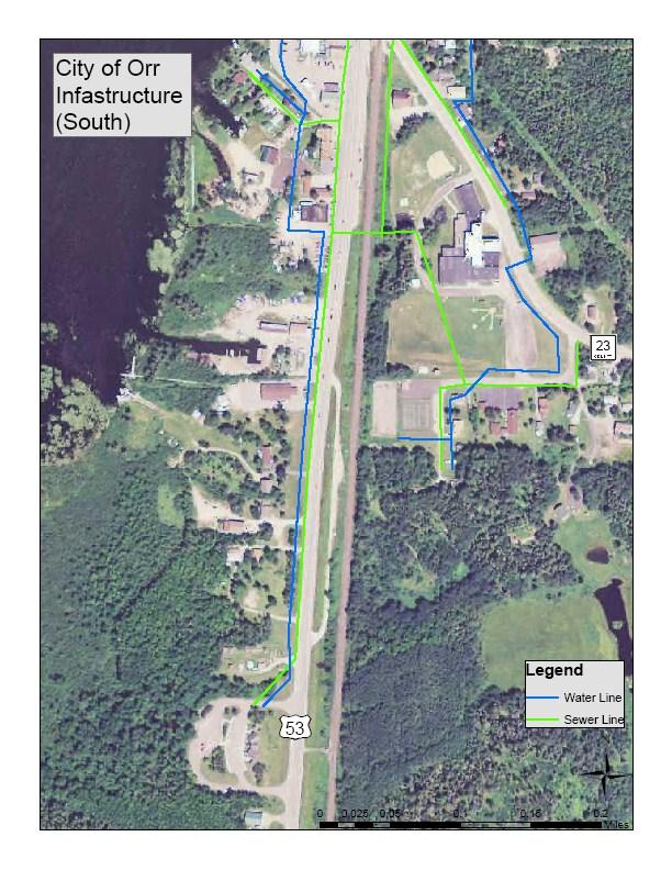
18 12.0 Make any necessary improvements to City Infrastructure on Highway 23 during planned reconditioning project A recondition project on Highway 23 is programed in 2016 between Highway 53 in Orr and Autio Road. This project is approximately 6.14 miles long with the cost of approximately $3 million Address any issues with City infrastructure on Highway 23 near the school while St. Louis County is repairing the road Upgrade all sewage and water pipes from 4 to 6 inch in the City. Collaborate with road jurisdiction to ensure project conjunction The City would like to have all sewage piping within the City be at 6 inch. Much of the piping in the City is up to this standard, but some locations are in need and maintenance needs to be completed to address concerns Upgrade water pipe from 4 to 6 inch behind Normans One Stop Upgrade sewage pipe form 4 to 6 inch along Hill Crest Road Upgrade sewage pipe from 4 to 6 inch along King Road. This road also needs to be repaved. Collaborate with St. Louis County while the road is disassembled for road work to improve the pipe in this location. 15
19 14.0 Increase sidewalk facilities throughout the community Sidewalks typically cost $4.50 per linear feet to install. The community has expressed its desire to have more pedestrian options and the need for sidewalks. Sidewalks promote economic development through easier access to businesses. Existing sidewalk facilities are currently being used to access downtown area by vehicles and for parking Determine where sidewalks could be located with local resident, business owner, and engineer support Explore potential for a Pelican Lake Trail A mountain bike trail encircling the lake would be an additional amenity to the area that the resorts could promote. The trail could potentially parallel Highway 23 on the south side of the lake and would go through state forest lands on the north side before using road corridors again on the north east corner of the lake near Orr. A trail encircling Pelican Lake would be about 27 miles total Explore the possibility of developing a trail that wraps around Pelican Lake. This potential trail would connect the City s downtown with resorts and businesses in the Orr area Set a meeting with the DNR to discuss the options of a potential trail facility. 16
20 Implementation Strategy Having an implementation strategy to fulfill projects within a plan is critical to a successful plan. A large number of projects within this Transportation Improvement Plan relate to improvements to the City s downtown and highway business district. To address the needs in this location and throughout the community, the City recognized the need to complete the Orr Community Improvement Design project. Also as part of the City s Comprehensive Plan, this design project will include elements of the city-wide improvements from its Integrated Revitalization Strategy. The goal of this project is to cover the Strategy s three focus areas outlined in the Comprehensive Plan, which include Community Aesthetics, Pedestrian Improvements and Community Destination Development. In the Summer of 2012, the Orr Community Improvement Design Project was fully funded through the Northeast Minnesota Sustainable Development Partnership (NMSDP), Iron Range Resources and Rehabilitation Board (IRRRB) and the Minnesota Department of Transportation (MnDOT). The City has identified LHB, Inc. as the lead design team. This project will begin the Fall of 2012 and completed in early
21 State and Federal Transportation Programs Moving Ahead for Progress in the 21st Century (MAP-21) On July 9, 2012, President Obama signed into law MAP-21, the long awaited surface transportation reauthorization bill. One week earlier, the U.S House of Representatives and U.S Senate cleared a bipartisan agreement for the two-year reauthorization of highway, public transit, and other surface transportation programs that included an extension of current student loan rates and flood insurance reauthorization. This marked the first multi-year reauthorization of surface transportation programs since the most recent long-term measure was signed into law in 2005 titled Safe, Accountable, Flexible, and Efficient Transportation Equity Act: A Legacy for Users (SAFETEA-LU). That measure expired in 2009, which left programs running on a series of extensions until this reauthorization. Overall, this bill reauthorizes surface transportation programs through fiscal year This funding mostly stays at previous levels with some programs receiving increases for inflation. This bill also consolidates highway programs and includes provisions to accelerate federal environmental review of construction projects. State Transportation Improvement Program (STIP) The State Transportation Improvement Program (STIP) is a comprehensive four-year schedule of planned transportation projects in Minnesota based on state fiscal years. The projects in this program are for state trunk highways, local roads and bridges, rail crossing projects, and transit capital and operating assistance. The document represents the investment dollars in federal, state, and local funds over the four year period. The document is the statewide transportation program in which the Minnesota Department of Transportation (MnDOT), local governments, and community and business interest groups worked together in eight District Area Transportation Partnerships (ATPs) to discuss regional priorities and reach agreement on important transportation investments. This state process was developed in response to the Federal Intermodal Surface Transportation Efficiency Act (ISTEA) of 1991 which focused on enhanced planning process, greater state and local government responsibility, and more citizen input to decision making. Northeast Minnesota Area Transportation Partnership (NE MN ATP) The Northeast Minnesota Area Transportation Partnership (NE MN ATP) is a committee of elected officials, engineers, planners, and other agency representatives from an eight county area of northeast Minnesota. Approximately $42 million per year of federal formula funds is allocated to the region. The role of the ATP to prioritize the spending of available federal dollars by developing the Area Transportation Improvement Program 18
22 (ATIP), which is a four-year list of prioritized projects. The list is submitted to MnDOT, which gives final approval to the ATIP, making it part of the STIP. Arrowhead Regional Development Commission (ARDC) participates in the NE MN ATP by providing assistance with the ATP processes, voting member of the ATP Policy Board, other assistance as requested, and administers the Transportation Enhancements process. Transportation Enhancements were a category of transportation projects eligible for federal funding under the Transportation Equity Act: A Legacy for Users (TEA-LU). These funds are still available under MAP-21, but have been consolidated into program titled Transportation Alternatives with other programs such as Safe Routes to School, Recreational Trails and Scenic Byways. Enhancements projects are defined as transportation-related activities that are designed to strengthen the cultural, aesthetic, and environmental aspects of the Nation s intermodal transportation system. The program provides funding for the implementation of a variety of projects within the bike and pedestrian facilities category. 19
23 APPENDICES
24 APPENDIX A CITY OF ORR INFASTRUCTURE MAPS
25

26

27

28
29 Strategy 1.0: Enhance the North Parking Area 2.0: Develop a Public Marina 3.0: Enhance Community Signage Action Step 1.1: Convey the importance of the North Parking Area while planning to make updates to the downtown. 1.2: Notify MnDOT of the spring in this area and encourage the installation of drain tile. 1.3: Include signage to the area to make visitors aware of the vehicle/ trailer parking opportunity. 2.1: Work with the DNR to determine what types of updates could happen in this area. 2.2: Include this area while planning to make updates to the downtown. 3.1: Work with the Design Team to create designs for a City Entrance Sign. 3.2: Work with the Design Team to create navigational signs for local and area attractions. Parties Involved Implementation Steps Time Line Status Orr Design 1. Include this area during the Short Term Committee, LHB Inc. discussions and final designs of the Community Improvement Design Project. City of Orr, MnDOT 1. Contact MnDOT District 1 Office to Short Term inform them the needs of the City at Orr Design Committee, LHB Inc. City of Orr, Orr Design Committee, DNR, LHB Inc. Orr Design Committee, LHB Inc. Orr Stakeholders, Orr Design Committee, LHB Inc. the location. 1. Include signage to the North Parking Area in the discussions and final designs of the Community Improvement Design Project. 1. Meet with the DNR during the Community Improvement Design Project development to determine potential redevelopments. 1. Include this area during the discussions and final designs of the Community Improvement Design Project. 1. Ensure designs for a City Entrance Sign are included during the discussions and final designs of the Orr Community Improvement Design Project. Orr Design 1. Ensure navigational signage that Committee, MnDOT, promotes local and area attractions St. Louis County, LHB are included during discussions and Inc. final designs of the Orr Community Improvement Design Project. Short Term Short Term Short Term Short Term Short Term 4.0: Develop a Community Trail 3.3: Enhance signage to the entrance of the Gheen Hill Trails. 4.1: Determine the alignment of the trail in a design process with local resident, business owner, and engineer support. City of Orr, Orr Design Committee, MnDOT, DNR City of Orr, Orr Stakeholders, Orr Design Committee, LHB Inc. 1. Ensure signage enhancements for the Gheen Hill Trails are included in discussions and final designs of the Orr Community Improvement Design Project. 1. Ensure the community trail is discussed and included in the final designs of the Orr Community Improvement Design Project. Short Term Short Term Orr Transportation Improvement Plan Implementation Checklist Page 1 of 4
30 Strategy 5.1: Develop a Natural Surface (Mountain Bike) Trail 6.1: Work to control speed within the Hwy 53 Corridor in the City 7.0: Sustain the Orr Regional Airport 8.0: Ensure proper lighting above all transportation facilities within the community Action Step 5.1: Work with an experienced Mountain Bike Facility Developer to determine the feasibility of a trail at the Gheen Hill. 6.1: Ensure traffic calming devices along Hwy 53 are included in any redevelopments to the downtown corridor. 7.1: Maintain the Orr Regional Airport at its current status. 7.2: Continue to promote the Airport and seek opportunities for increasing its use. 8.1: Ensure all existing light poles within the City are in suitable condition. 8.2: Encourage Lake Country Power to continuously monitor and make necessary lighting repairs and improvements as needed. 8.3: Develop designs that enhance lighting throughout the community with a decorative theme. The decorative lighting should compliment the City's image. Parties Involved Implementation Steps Time Line Status City of Orr, DNR, 1. Meet with the cooperative partners Short Term Ruffed Grouse of the trail to discuss future Society, Bike Facility redevelopment opportunities. Developer 2. Document discussion items and ideas for opportunities. 3. Meet with an experienced Mountain Bike Facility Developer to express the desires of redevelopment to the area. City of Orr, Orr Design 1. Include traffic calming devices Committee, MnDOT, during the discussions and final St. Louis County, LHB designs of the Community Inc. Improvement Design Project. City of Orr, Orr Airport Manager City of Orr, Orr Pelican Lake Association, Orr Chamber of Commerce, Leiding Township, Others as needed City of Orr, Lake Country Power City of Orr, Lake Country Power Orr Design Committee, LHB Inc. 1. Work with the Airport Manager to maintain the facility. 2. Work with the Airport Manager to determine any needed updates. 1. Continue successful promotional activities. 2. Continue to seek new promotional opportunities. 1. Inventory locations of damaged light poles. 2. Contact Lake Country Power to inform them the locations of the damaged light poles. 1. Encourage continuous monitoring of the City's lighting. 2. Request repairs and improvements as needed. 1. Include decorative lighting during the discussions and final designs of the Community Improvement Design Project. Short Term Ongoing Ongoing Short Term, Ongoing Ongoing Short Term Orr Transportation Improvement Plan Implementation Checklist Page 2 of 4
31 Strategy 9.0: Complete maintenance to the Bog Walk 10.0: Improve parking and traffic flow in the downtown and highway business corridor 11.0: Include aesthetically pleasing features to transportation facilities within the City 12.0: Make any necessary improvements to City infrastructure on Highway 23 during planned reconditioning project 13.0: Upgrade all sewage and water pipes from 4 to 6 inch in the City. Collaborate with road jurisdiction to ensure project conjunction. Action Step 9.1: Develop a strategy to complete maintenance to the trail. 9.2: Seek and install low cost, long lasting maintenance solutions. 10.1: Seek to improve traffic flow and safety along Johnson Parkway. 10.2: Ensure parking and traffic flow improvements are accommodating to bicycles and pedestrians. 11.1: Design improvements for plantings or other visual improvements throughout the City including areas near the railroad. 12.1: Address any issues with City infastructure on Highway 23 near the school while St. Louis County is repairing the road. 13.1: Upgrade water pipe from 4 to 6 inch behind Normans One Stop. Parties Involved Implementation Steps Time Line Status City of Orr, DNR 1. Contact the DNR to determine Short Term how maintenance work can be completed in the swamp. 2. Conduct an initial assessment of the trail to determine the current and long term needs. 3. Determine if the City should seek assistance in developing a long term maintenance strategy. City of Orr 1. Ensure research is completed to Mid Term determine that best practices are followed during maintenance installation. Orr Design 1. Ensure Johnson Parkway is Short Term Committee, LHB Inc. included during discussions and final designs of the Community Orr Design Committee, LHB, Inc. Orr Design Committee, LHB Inc. Improvement Design Project. 1. Ensure the needs of bicyclists and pedestrian are included during discussions and final designs of the Community Improvement Design Project. 1. Ensure aesthetically pleasing features such as plantings are included during discussions and final designs of the Community Improvement Design Project. 1. Ensure St. Louis County is aware of the City's planned infastructure updates. 2. Address issues while St. Louis County repairs the Highway. City of Orr 1. Upgrade sewage pipe from 4 to 6 inch behind Normans One Stop. Short Term Short Term Mid Term Short Term Orr Transportation Improvement Plan Implementation Checklist Page 3 of 4
32 Strategy Action Step 13.2: Upgrade sewage pipe from 4 to 6 inch along Hill Crest Road. Parties Involved Implementation Steps Time Line Status City of Orr 1. Upgrade sewage pipe from 4 to 6 Long Term inch along Hill Crest Road. 2. Collaborate with road construction contractor to complete road repairs and infastructure updates at the same time. 14.0: Increase sidewalk facilities throughout the community 13.3: Upgrade sewage pipe from 4 to 6 inch along King Road. This road also needs to be repaved. Collaborate with St. Louis County while the road is disassembled for road work to improve the pipe in this location. 14.1: Determine where sidewalks could be located with local resident, business owner, and engineer support. City of Orr, St. Louis County City of Orr, Orr Stakeholders, Orr Design Committee, LHB Inc. 1. Upgrade sewage pipe from 4 to 6 inch along King Road. 2. Collaborate with St. Louis County to complete the upgrade while the County is working on the road. 1. Ensure locations of sidewalk facilities are discussed and included in the final designs of the Community Improvement Design Project. Long Term Short Term 15.0: Explore potential for a Pelican Lake Trail 15.1: Explore the possibility of developing a trail that wraps around Pelican Lake. This potential trail would connect the City's downtown with resorts and businesses in the Orr area. City of Orr, Orr Stakeholders, Orr Design Committee 1. Discuss potential trail with Orr Stakeholders. 2. Document stakeholder feedback in regards to potential trail surface, uses, general alignment, etc. Short Term 15.2: Meet with the DNR to discuss the options of a potential trail facility around the lake. City of Orr, DNR 1. Set a meeting with the DNR. 2. Use stakeholder feedback developed in Action Step 15.1 to express the desires of the community. Short Term Orr Transportation Improvement Plan Implementation Checklist Page 4 of 4
33 CITY OF ORR TRANSPORTATON IMPROVEMENT PLAN JUNE 2012 Prepared for the City of Orr Prepared with assistance from Regional Transportation Advisory Committee and Regional Planning Division Arrowhead Regional Development Commission ARDC s Mission To serve the people of the Arrowhead Regional by providing local units of government and citizens groups a means to work cooperatively in identifying needs, solving problems, and fostering local leadership. If you have questions regarding ARDC, Regional Transportation Advisory Committee or the City of Orr, please contact: Andy Hubley Regional Planning Division Arrowhead Regional Development Commission 221 West First St. Duluth, MN Phone: Fax: Website: ahubley@ardc.org
NORTHEAST CARLTON COUNTY BICYCLE ROUTE PLAN
 NORTHEAST CARLTON COUNTY BICYCLE ROUTE PLAN 5/31/2014 and St. Louis River Trail Plan Update Produced by the Arrowhead Regional Development Commission (ARDC) in Partnership with the State Health Improvement
Non-Motorized Transportation
 Non-Motorized Transportation Non-motorized facilities are important components to the transportation system. They provide an environmentally-friendly, low-cost mode of travel. Some of the facilities can
City of Durango 5.8 FUNDING TRAILS DEVELOPMENT
 5.8 FUNDING TRAILS DEVELOPMENT The City has been successful in establishing dedicated local funding sources as well as applying for grants to develop the City s trail system, having received nearly $2.4
MEETING MINUTES District 1 Trail Planning Meeting 1
 MEETING MINUTES District 1 Trail Planning Meeting 1 June 1, 2017 2:00 PM 3:30 PM City of Two Harbors 2:00 Introductions Attendees: Lisa Austin, MnDOT Bryan Anderson, MnDOT Jasna Hadzic-Stanek, MnDOT Justin
University Region Non-Motorized Plan 2015
 Non-Motorized Transportation Non-motorized facilities are important components to the transportation system. They provide an environmentally-friendly, low-cost mode of travel. Some of the facilities can
Business Item No XXX. Proposed Action That the Metropolitan Council approve the Coon Creek Regional Trail Master Plan.
 Business Item No. 2015-XXX Metropolitan Parks and Open Space Commission Meeting date: July 7, 2015 For the Community Development Committee meeting of July 20, 2015 For the Metropolitan Council meeting
Blueways: Rivers, lakes, or streams with public access for recreation that includes fishing, nature observation, and opportunities for boating.
 Parks, Open Space and Trails PRINCE WILLIAM COUNTY 2008 COMPREHENSIVE PLAN TRAILS PLAN CONTENTS The components of the trails plan are: Intent Definitions Goals, Policies, and Action Strategies Trails Map
Committee Report. Community Development Committee For the Metropolitan Council meeting of August 12, Business Item No.
 Committee Report Business Item No. 2015-168 Community Development Committee For the Metropolitan Council meeting of August 12, 2015 Subject: Coon Creek Regional Trail Master Plan, Anoka County Proposed
A CASE FOR COMPLETING THE JORDAN RIVER PARKWAY: A
 A CASE FOR COMPLETING THE JORDAN RIVER PARKWAY: A safe crossing at 9000 South and 850 West Proposed 9000 South Underpass Parkway Timeline Parkway, Trail, and Tourism Facts Blueprint Jordan River 1971 1973
Greater Minnesota Regional Parks and Trails Commission Designation Application
 Greater Minnesota Regional Parks and Trails Commission Designation Application General Section Designation Application #: 15-059D Date Submitted: 06/16/2015 Park or Trail Name: Mesabi Trail District #:
Georgetown-Lewes Rail/Trail Study. Rail/Trail Study: Cool Spring to Cape Henlopen State Park New Road Extension (House Resolution No.
 Georgetown-Lewes Rail/Trail Study Rail/Trail Study: Cool Spring to Cape Henlopen State Park New Road Extension (House Resolution No. 47) August 22, 2011 Presentation Outline Background Benefits Statewide
F. Forest Recreation Management
 F. Forest Recreation Management F.1) Park and Recreation Management F.1.A. Program Overview. The park and recreation program has been in existence since 1980. With ever increasing outdoor recreation demands
2. Goals and Policies. The following are the adopted Parks and Trails Goals for Stillwater Township:
 D. PARKS AND TRAILS 1. Introduction Stillwater Township s population is relatively low, with most residents living on rural residences on large lots. The need for active park space has been minimal in
Business Item No
 Metropolitan Parks and Open Space Commission Meeting date: February 6, 2018 For the Community Development Committee meeting of February 20, 2018 For the Metropolitan Council meeting of February 28, 2018
Cascade River State Park Management Plan Amendment
 This document is made available electronically by the Minnesota Legislative Reference Library as part of an ongoing digital archiving project. http://www.leg.state.mn.us/lrl/lrl.asp Cascade River State
Segment 2: La Crescent to Miller s Corner
 goal of the USFWS refuges is to conserve, protect and enhance fish, wildlife and plants and their habitats for the continuing benefit of the American people. Refuge lands are used largely for fishing,
Proposal to Redevelop Lower Kananaskis River-Barrier Lake. Bow Valley Provincial Park. Frequently Asked Questions
 Proposal to Redevelop Lower Kananaskis River-Barrier Lake Bow Valley Provincial Park Frequently Asked Questions What is being proposed? What are the details of the proposal? Where is the project area located?
Longmont to Boulder Regional Trail Jay Road Connection DRAFT FINAL REPORT
 Longmont to Boulder Regional Trail Jay Road Connection DRAFT FINAL REPORT December 2018 Project Summary Boulder County, Colorado, in partnership with the City of Boulder, is evaluating options for multi-use
MASTER PLAN EXECUTIVE SUMMARY
 Biscuit Run State Park Scottsville Road (State Route 20) Charlottesville, VA 22902 Biscuit Run State Park MASTER PLAN EXECUTIVE SUMMARY Department of Conservation and Recreation Division of Planning and
Lafourche Parish Government REQUEST FOR QUALIFICATIONS. Landscape Architectural Services
 Lafourche Parish Government REQUEST FOR QUALIFICATIONS Landscape Architectural Services Bayou Lafourche Parish Multi-Use Path Feasibility Study Phase 1 And Bayou Lafourche Parish Multi-Use Path Feasibility
AGENDA ITEM 5 D WAKULLA ENVIRONMENTAL INSTITUTE (WEI) TRAIL FEASIBILITY STUDY
 TRAIL FEASIBILITY STUDY") March 19, 2018 AGENDA ITEM 5 D WAKULLA ENVIRONMENTAL INSTITUTE (WEI) TRAIL FEASIBILITY STUDY TYPE OF ITEM: Action STATEMENT OF ISSUE The Wakulla Environmental Institute (WEI) Trail is one of several trails
March 19, 2018 AGENDA ITEM 5 D WAKULLA ENVIRONMENTAL INSTITUTE (WEI) TRAIL FEASIBILITY STUDY TYPE OF ITEM: Action STATEMENT OF ISSUE The Wakulla Environmental Institute (WEI) Trail is one of several trails
THE SETTING REGION COMMUNITY ANALYSIS
 THE SETTING REGION COMMUNITY ANALYSIS REGION Historical Setting The Crane Lake waterway pre-dates the American Indians who traveled its waters for generations before it became a fur-trading route for the
Airport Planning Area
 PLANNING AREA POLICIES l AIRPORT Airport Planning Area LOCATION AND CONTEXT The Airport Planning Area ( Airport area ) is a key part of Boise s economy and transportation network; it features a multi-purpose
Project Summary 2009
 Project Summary 2009 SB-2009-MN-55360: Lady Slipper Scenic Byway Pedestrian Walkway State Submission Date not submitted Division Submission Date not submitted State Priority 0 This application must be
Aviation, Rail, & Trucking 6-1
 6-1 This chapter describes the services, facilities, and condition of air, rail, and trucking as components of the transportation system. These three intermodal areas have an impact on the factors to be
Proposal to Redevelop Lower Kananaskis River-Barrier Lake. Bow Valley Provincial Park
 Frequently Asked Questions Proposal to Redevelop Lower Kananaskis River-Barrier Lake Bow Valley Provincial Park Frequently Asked Questions What has been decided? What are the details of the plan? What
13.1 REGIONAL TOURISM ISSUES AND SUMMARY OF FINDINGS
 13 REGIONAL TOURISM T he County of Mariposa s recreation needs and facilities fall within two categories: regional tourism and local recreation. This Element focuses on regional tourism issues related
Section II. Planning & Public Process Planning for the Baker/Carver Regional Trail began in 2010 as a City of Minnetrista initiative.
 Section II Planning & Public Process Planning for the began in 2010 as a City of initiative. city staff began discussions with the Park District on the possibility of a north/south regional trail connection
The Corporation of the City of Kawartha Lakes Council Report
 The Corporation of the City of Kawartha Lakes Council Report Report Number ENG2017-008 Date: September 12, 2017 Time: 2:00 p.m. Place: Council Chambers Ward Community Identifier: All Subject: Author Name
JOSLIN FIELD, MAGIC VALLEY REGIONAL AIRPORT DECEMBER 2012
 1. Introduction The Federal Aviation Administration (FAA) recommends that airport master plans be updated every 5 years or as necessary to keep them current. The Master Plan for Joslin Field, Magic Valley
Greater Minnesota Regional Parks and Trails Commission Designation Application
 Greater Minnesota Regional Parks and Trails Commission Designation Application General Section Designation Application #: 15-050D Date Submitted: 06/30/2015 Park or Trail Name: Perham to Pelican Rapids
IL 390 Station. Wood Dale Open House Summary 5/18/17
 Wood Dale Open House Summary 5/18/17 The first public open house for the Wood Dale Comprehensive Plan took place on May 18 th, 2017. The program was conducted as a fun community event and there were 216
Mississippi River Parkway Commission of Minnesota
 Mississippi River Parkway Commission of Minnesota Metro Region (Elk River to Hastings) October 27, 2016 2:00 3:30 p.m. Historic Fort Snelling 200 Tower Avenue, St. Paul, MN Metro Region Agenda I. Welcome
2016 Regional Transportation Alternatives Program (TAP) Grant Application
 Grant Application") 2016 Regional Transportation Alternatives Program (TAP) Grant Application PROJECT TITLE: Yelm-Tenino Trail Extension Feasibility Study TRPC use only GENERAL PROJECT INFORMATION Agency or Organization City
2016 Regional Transportation Alternatives Program (TAP) Grant Application PROJECT TITLE: Yelm-Tenino Trail Extension Feasibility Study TRPC use only GENERAL PROJECT INFORMATION Agency or Organization City
The Future of the Road to Revolutions. A Battle Road Scenic Byway Public Forum November 9, 2010
 The Future of the Road to Revolutions A Battle Road Scenic Byway Public Forum November 9, 2010 Who is the Battle Road Scenic Byway? Four Towns: Arlington, Lexington, Lincoln, Concord Minute Man National
Glacial Lakes State Trail Master Plan Amendment Trail Extension into Downtown Willmar
 Glacial Lakes State Trail Master Plan Amendment Trail Extension into Downtown Willmar Minnesota Department of Natural Resources Division of Parks and Trails July 2012 Glacial Lakes State Trail Master Plan
Minnesota Great River Road Transportation Alternatives Local Project Summaries December 19, 2016
 Minnesota Great River Road Transportation Alternatives Local Project Summaries December 19, 2016 For MN-MRPC Consideration on January 5, 2017 and Potential Letters of Support Aitkin pg. 2 Brainerd pg.
Gold Coast. Rapid Transit. Chapter twelve Social impact. Chapter content
 Gold Coast Rapid Transit Chapter twelve Social impact Chapter content Social impact assessment process...235 Existing community profile...237 Consultation...238 Social impacts and mitigation strategies...239
Preferred Recreation Recommendations Stemilt-Squilchuck Recreation Plan March 2018
 Preferred Recreation Recommendations Stemilt-Squilchuck Recreation Plan March 2018 Below are the recommended recreation ideas and strategies that package together the various recreation concepts compiled
The Recreational Trail along Cushing Park road has been a successful addition to the city
 The Recreational Trail along Cushing Park road has been a successful addition to the city Trails TRAILS, PATHS, ROUTES AND CONNECTORS Citizen input pointed to trails, paths, bike routes, and other non-motorized
Chapter 1: Introduction Draft
 Chapter 1: Draft TABLE OF CONTENTS 1... 4 1.6.1 Stakeholder Engagement Plan... 10 Chapter 1 Page 2 TABLE OF EXHIBITS Exhibit 1.1-1 ABIA Annual Growth Since 1993... 5 Exhibit 1.4-1: ABIA Location Map...
CHAPTER FOUR: TRANSPORTATION
 CHAPTER FOUR: TRANSPORTATION Barron County Comprehensive Plan: Transportation Page 61 Background Transportation facilities have a significant influence on land use, development and quality of life for
METROPOLITAN COUNCIL 390 North Robert Street, St. Paul, MN Phone (651) TDD (651)
 TDD (651)") METROPOLITAN COUNCIL 390 North Robert Street, St. Paul, MN 55101 Phone (651) 602 1000 TDD (651) 291 0904 DATE: June 19, 2007 TO: Metropolitan Parks and Open Space Commission FROM: Jan Youngquist, Senior
METROPOLITAN COUNCIL 390 North Robert Street, St. Paul, MN 55101 Phone (651) 602 1000 TDD (651) 291 0904 DATE: June 19, 2007 TO: Metropolitan Parks and Open Space Commission FROM: Jan Youngquist, Senior
Welcome to the future of Terwillegar Park a Unique Natural Park
 Welcome to the future of Terwillegar Park a Unique Natural Park 1 Introduction The Terwillegar Park Concept Plan study will develop an overall concept plan, management objectives and development guidelines
Regional Wayfinding Sign Strategy Thurston County Trails 2017
 Regional Wayfinding Sign Strategy Thurston County Trails 2017 Partners: Members and partnering organizations of the Thurston Thrives Community Design Action Team City of Lacey, City of Olympia, City of
Schoolcraft Township is located in northeast Houghton County. A portion of the township borders Keweenaw County and Lake Superior.
 COMMUNITY DESCRIPTION Schoolcraft Township is located in northeast Houghton County. A portion of the township borders Keweenaw County and Lake Superior. The township is largely rural but has one main population
Agenda: SASP SAC Meeting 3
 Agenda: SASP SAC Meeting 3 Date: 04/12/18 Public Involvement Plan Update Defining the System Recommended Classifications Discussion Break Review current system Outreach what we heard Proposed changes Classification
CHAPTER 5. Chapter 5 Recreation Element
 CHAPTER 5 Recreation Element Chapter 5 Recreation Element The Recreation Element of the Meyers Area Plan is a supplement to the Recreation Element of the TRPA Regional Plan and the El Dorado County General
Chapter 6: POLICY AND PROCEDURE RECOMMENDATIONS
 Chapter 6 POLICY AND PROCEDURE RECOMMENDATIONS FOR SRRA Below are seven policy elements that should be considered for adoption by the Southwest Regional Recreation Authority of Virginia: 1. Develop strategies
Chapter 1: Introduction
 Chapter 1: TABLE OF CONTENTS 1... 4 1.1 Master Plan Study Content... 4 1.2 Purpose and Scope of Master Plan Study... 4 1.3 Airport History and Role... 6 1.4 Airport Location and Service Area... 6 1.5 ABIA
Committee. Presentation Outline
 CW-33-15 11/9/2015 Community and Corporate Services Committee November 10, 2015 1 Presentation Outline Background Vision and Objectives Study Process and Timeline Public and Stakeholder Engagement Organization
Committee Report. Community Development Committee For the Metropolitan Council meeting of April 13, Business Item No.
 Committee Report Business Item No. 2016-48 Community Development Committee For the Metropolitan Council meeting of April 13, 2016 Subject: Harriet Island-South St. Paul Regional Trail Master Plan, Saint
Welcome to the Illinois High-Speed Rail Chicago to St. Louis Construction Update Meeting. Today s meeting will provide an overview of the Program,
 Welcome to the Illinois High-Speed Rail Chicago to St. Louis Construction Update Meeting. Today s meeting will provide an overview of the Program, updates on construction to be held in this area, and how
Implementation Strategy for the Lethbridge Destination Management Organization (LDMO)
") Implementation Strategy for the Lethbridge Destination Management Organization (LDMO) IMPLEMENTATION AND TRANSITION STRATEGY LDMO MANDATE: To establish a destination management organization that provides
Implementation Strategy for the Lethbridge Destination Management Organization (LDMO) IMPLEMENTATION AND TRANSITION STRATEGY LDMO MANDATE: To establish a destination management organization that provides
Clackamas County Development Agency
 Clackamas County Development Agency Development Services Building, 150 Beavercreek Rd., Oregon City, OR 97045 www.clackamas.us/transportation/renewal 503-742-4323 The Clackamas County Board of Commissioners
Rogue River Access and Management Plan Draft Alternatives
 Rogue River Access and Management Plan Draft Alternatives The Rogue River Access and Management Plan was initiated in December, 2011 and is being led by Jackson County Parks (JCP) and Oregon Department
Draft Executive Summary
 Draft Executive Summary The Juneau Tourism Plan development process was undertaken by Egret Communications and ARA Consulting in April 2001, under contract with the City and Borough of Juneau, Alaska.
CRANE LAKE TRAILS NETWORK AND SPACES
 CRANE LAKE TRAILS NETWORK AND SPACES AREA TRAILS COMMUNITY TRAILS GOLD COAST TRAIL LAKE PARK OPTION ONE LAKE PARK OPTION TWO OVERFLOW TRAILHEAD PARKING THE GATE AREA TRAILS Trails are a major resource
COUNTY COMPREHENSIVE PLAN
 50 : Policy Statement Lewis County has a unique and attractive rural character, which makes it a wonderful place to visit and explore. The region abounds with recreation opportunities that attract visitors
MUNICIPALITY OF ANCHORAGE
 MUNICIPALITY OF ANCHORAGE ANCHORAGE PARKS & RECREATION Memorandum PRC 08-56 DATE: 5 August 2008 TO: FROM: SUBJECT: Parks & Recreation Commission Holly Spoth-Torres, Park Planner PRC 08-56 Far North Bicentennial
Community Development Committee
 C Community Development Committee For the Metropolitan Council meeting of October 31, 2012 Committee Report Item:2012-316 ADVISORY INFORMATION October 16, 2012 Date Prepared: Subject: Intercity Regional
ANNUAL BUSINESS PLAN
 RIDEAU HERITAGE ROUTE TOURISM ASSOCIATION ANNUAL BUSINESS PLAN 2011 Aug 18, 2010 AMPLITUDE Tourism Consulting RHRTA BUSINESS PLAN 2011 1 TABLE OF CONTENTS 1.0 Executive summary 2.0 Association Profile
WESTERN EL DORADO COUNTY SHORT AND LONG-RANGE TRANSIT PLAN Executive Summary
 WESTERN EL DORADO COUNTY SHORT AND LONG-RANGE TRANSIT PLAN Executive Summary Prepared for the El Dorado County Transportation Commission Prepared by The El Dorado County Transportation Commission (EDCTC)
Economic Development and Tourism
 SECTION 4 SECTION 4 Economic Development and Tourism 4. Economic Development and Tourism Tourism plays a very important role in Niagara s economy, providing employment and generating business for support
4.0 Context for the Crossing Project
 4.0 Context for the Crossing Project This section provides background information about key features of the North Douglas Crossing project area, and opportunities and constraints. This information is important
Public Notice ISSUED: December 10, 2018 EXPIRES: January 9, 2019
 APPLICANT: REFER TO: St. Louis and Lake Counties Regional Rail Authority 2018-01942-ARC Public Notice ISSUED: December 10, 2018 EXPIRES: January 9, 2019 SECTION:404 - Clean Water Act 1. APPLICATION FOR
This section provides the basic information about the park or trail and the organizations responsible for it. Funding Application F
 General This section provides the basic information about the park or trail and the organizations responsible for it. Park/Trail ID # 16-43D Last Update July 13, 217 District 2 Funding Application 17-82-F
DRAFT - APRIL 13, 2007 ROUTING STUDY FOR TRAIL CONNECTIONS BETWEEN CALAIS AND AYERS JUNCTION
 DRAFT - APRIL 13, 2007 ROUTING STUDY FOR TRAIL CONNECTIONS BETWEEN CALAIS AND AYERS JUNCTION Abstract The vision for the East Coast Greenway is an off-road urban trail system running from Calais, Maine
Saginaw Charter Township Master Plan
 Saginaw Charter Township Master Plan Overview of Draft & Public Hearing August 20, 2014 230 South Washington Avenue Saginaw Michigan 48607 (989) 754-4717 www.spicergroup.com Saginaw Charter Township Master
Mississippi River Parkway Commission of Minnesota
 Mississippi River Parkway Commission of Minnesota Bluffs Region (Hastings to Iowa Border) September 23, 2016 10:00 11:30 a.m. Red Wing Ignite 419 Bush Street, Red Wing, MN Bluffs Region Agenda I. Welcome
TORONTO TRANSIT COMMISSION REPORT NO. SUBJECT: TORONTO-YORK SPADINA SUBWAY EXTENSION STATION NAMES IN THE CITY OF VAUGHAN
 TORONTO TRANSIT COMMISSION REPORT NO. MEETING DATE: February 29, 2011 SUBJECT: TORONTO-YORK SPADINA SUBWAY EXTENSION STATION NAMES IN THE CITY OF VAUGHAN ACTION ITEM RECOMMENDATIONS It is recommended that
Proposed Action. Payette National Forest Over-Snow Grooming in Valley, Adams and Idaho Counties. United States Department of Agriculture
 United States Department of Agriculture Forest Service January 2012 Proposed Action Payette National Forest Over-Snow Grooming in Valley, Adams and Idaho Counties Payette National Forest Valley, Adams
PURPOSE AND NEED (CONCURRENCE POINT 1) NEW CANADA ROAD PROJECT FROM STATE ROUTE 1 (U.S. HIGHWAY 70) TO U.S. INTERSTATE 40
 NEW CANADA ROAD PROJECT FROM STATE ROUTE 1 (U.S. HIGHWAY 70) TO U.S. INTERSTATE 40") PURPOSE AND NEED (CONCURRENCE POINT 1) NEW CANADA ROAD PROJECT FROM STATE ROUTE 1 (U.S. HIGHWAY 70) TO U.S. INTERSTATE 40 Project Description The primary purpose of this project is to improve the major
PURPOSE AND NEED (CONCURRENCE POINT 1) NEW CANADA ROAD PROJECT FROM STATE ROUTE 1 (U.S. HIGHWAY 70) TO U.S. INTERSTATE 40 Project Description The primary purpose of this project is to improve the major
THREE MILE PLAN TOWN OF SUPERIOR COLORADO
 THREE MILE PLAN TOWN OF SUPERIOR COLORADO February 23, 2015 INTRODUCTION This document has been prepared by the Town of Superior, Colorado, to address the existing and proposed land uses within an approximate
Ministry of Parks, Culture and Sport. Plan for saskatchewan.ca
 Ministry of Parks, Culture and Sport Plan for 2018-19 saskatchewan.ca Table of Contents Statement from the Minister... 1 Response to Government Direction... 2 Operational Plan... 3 Highlights... 7 Financial
Executive Summary. MASTER PLAN UPDATE Fort Collins-Loveland Municipal Airport
 Executive Summary MASTER PLAN UPDATE Fort Collins-Loveland Municipal Airport As a general aviation and commercial service airport, Fort Collins- Loveland Municipal Airport serves as an important niche
Mohawk Hudson Bike Hike Trail Crossroad Connection Study
 Summary Report - April 21, 2003 Mohawk Hudson Bike Hike Trail Crossroad Connection Study Summary Report Introduction The Capital District Transportation Committee (CDTC), in partnership with Albany County,
RUSHMORE CONNECTOR TRAIL PROPOSAL
 PURPOSE AND NEED Background The U.S. Forest Service, Black Hills National Forest (Forest Service) has received a special use permit application from the State of South Dakota Department of Game, Fish and
ARLINGTON COUNTY, VIRGINIA
 ARLINGTON COUNTY, VIRGINIA County Board Agenda Item Meeting of April 16, 2005 DATE: March 28, 2005 SUBJECTS: A. Adoption of the Fort Myer Heights North Plan. B. GP-300-04-1 Adoption of the following General
Other Principle Arterials Minor Arterial Major Collector Minor Collector Local
 CHAPTER 10 TRANSPORTATION Introduction The system of public roads in East Pikeland Township is decidedly rural in character. Since the 1984, the road network has remained much the same, with the addition
National Scenic Byways Program US Department of Transportation
 1 2 National Scenic Byways Program US Department of Transportation Abstract The Cowlitz-Wahkiakum Council of Governments in partnership with Cowlitz, Skamania and Lewis Counties and the U.S. Forest Service,
Emily to Blind Lake Trail PROPOSED TRAIL DEVELOPMENT APPLICATION SUMMARY
 Emily to Blind Lake Trail PROPOSED TRAIL DEVELOPMENT APPLICATION SUMMARY Township 137 Range 26 (Fairfield Township) sections 2 & 3 Township 138 Range 26 (City of Emily) sections 27, 34, 35, & 36 Township
Table of Contents. page 3 Long term Goals Project Scope Project History. 4 User Groups Defined Trail Representative Committee. 5 Trail Users Breakdown
 Launched April 27th, 2010 1 Table of Contents page 3 Long term Goals Project Scope Project History 4 User Groups Defined Trail Representative Committee 5 Trail Users Breakdown 13 Trail Users Desires 16
Area Surrounding Maplewood Manor
 BAY CITY, MICHIGAN HOUSING COMMISSION Neighborhood Revitalization Plan Area Surrounding Maplewood Manor January 13, 2014 CITY COMMISSION DRAFT PLAN PRESENTATION BAY CITY, MICHIGAN 1 Planners Phil McKenna,
Tallahassee-St. Marks Historic Railroad Trail
 Revitalizing a Historic Trail Designated as a National Recreation Trail, the 16-mile Tallahassee-St. Marks Historic Railroad Trail has been enjoyed by countless bicyclists, runners, and outdoor enthusiasts
ADVENTURE PLAN EXPLORE PARK
 ADVENTURE PLAN ROANOKE COUNTY S EXPLORE PARK ROANOKE COUNTY PARKS, RECREATION AND TOURISM 1206 KESSLER MILL RD SALEM, VA 24153 (540) 387-6078 WHAT S INCLUDED? Explore Park Adventure Plan - Guided by extensive
CHAPTER 1: INTRODUCTION
 CHAPTER 1: INTRODUCTION Purpose and Scope The information presented in this report represents the study findings for the 2016 Ronan Airport Master Plan prepared for the City of Ronan and Lake County, the
The Baker/Carver Regional Trail is intended to
 Section V Design Guidance The Baker/Carver Regional Trail is intended to safely accommodate 183,000 annual visits, an array of non-motorized uses, a variety of skill levels, and persons with special needs.
Mechanized River Valley Access Public Engagement Report. April 2015
 Mechanized River Valley Access Public Engagement Report April 2015 Table of Contents Background... 1 Stakeholder Consultation... 3 What We Heard... 4 Conclusion... 7 Background The North Saskatchewan River
Fort Christanna Historical and Recreational Park
 Brunswick County, Virginia 2012 Virginia Association of Counties Achievement Award Submission Parks and Recreation Fort Christanna Historical and Recreational Park Brunswick County Fort Christanna Historical
A BOAT RAMP TO NOWHERE
 A BOAT RAMP TO NOWHERE A PROPOSAL FOR ACCESS TO HARVIE PASSAGE A Presentation to the City of Calgary December 2017 Presented by: Peter Crowe-Swords Bow River Trout Foundation Background: The Bow River
Stagecoach State Trail Master Plan
 Stagecoach State Trail Master Plan Minnesota Minnesota Department Department of of Natural Natural Resources Resources Parks and and Trails Trails Division Division Parks March March 2012 2012 The Minnesota
A Master Plan is one of the most important documents that can be prepared by an Airport.
 The Master Plan A Master Plan is one of the most important documents that can be prepared by an Airport. A Master Plan is a visionary and a strategic document detailing planning initiatives for the Airport
Resort Municipality Initiative Annual Report 2015
 Resort Municipality Initiative Annual Report 2015 Submitted by: City of Rossland in association with Tourism Rossland Prepared by: Deanne Steven Acknowledgements The City of Rossland would like to thank
Westover Metropolitan Airport Master Plan Update
 Westover Metropolitan Airport Master Plan Update June 2008 INTRODUCTION Westover Metropolitan Airport (CEF) comprises the civilian portion of a joint-use facility located in Chicopee, Massachusetts. The
Greater Orlando Aviation Authority
 Greater Orlando Aviation Authority Orlando International Airport & Orlando Executive Airport Budgets Fiscal Year 2017-2018 Greater Orlando Aviation Authority Orlando, Florida Greater Orlando Aviation Authority
FINAL TESTIMONY 1 COMMITTEE ON RESOURCES UNITED STATES HOUSE OF REPRESENTATIVES. July 13, 2005 CONCERNING. Motorized Recreational Use of Federal Lands
 FINAL TESTIMONY 1 STATEMENT OF DALE BOSWORTH CHIEF Of the FOREST SERVICE UNITED STATES DEPARTMENT OF AGRICULTURE Before the SUBCOMMITTEE ON FORESTS AND FOREST HEALTH And the SUBCOMMITTEE ON NATIONAL PARKS,
MESA COUNTY DEPARTMENT OF PUBLIC WORKS Administration - Building - Engineering Road and Bridge Traffic - Planning - Solid Waste Management
 MESA COUNTY DEPARTMENT OF PUBLIC WORKS Administration - Building - Engineering Road and Bridge Traffic - Planning - Solid Waste Management 200 S. Spruce St. P.O. Box 20,000 Grand Junction, Colorado 81502-5022
Lake Erie Commerce Center Traffic Analysis
 LOCATION: East of NYS Route 5 at Bayview Road Town of Hamburg Erie County, New York PREPARED BY: Wendel Companies 140 John James Audubon Parkway Suite 200 Amherst, New York 14228 January 2012 i ii Table
Classifications, Inventory and Level of Service
 Classifications, Inventory and Level of Service Section 3 Kenmore Park, Recreation and Open Space Plan 1 P a g e Classifications and Inventory Park Classifications Kenmore classifies its parks based upon