DALEY RANCH MASTER PLAN
|
|
|
- Brianne Turner
- 5 years ago
- Views:
Transcription
1 DALEY RANCH MASTER PLAN City of Escondido, California (97-04-GPIP) Adopted September 23, 1998 by Resolution
2 DALEY RANCH MASTER PLAN ACKNOWLEDGEMENTS: City Council Sid Hollins, Mayor Lori Holt Pfeiler, Mayor Pro-Tem Keith Beier Jerry C. Harmon June Rady Staff Members Rolf Gunnarson, City Manager Mike Adams, Assistant City Manager / Director of Public Works Don Anderson, Director of Community Services Charles D. Grimm, Director of Planning and Building Vic Reed, Fire Chief Ross M. Calarco, Deputy Director of Public Works Dale Mathre, Deputy Director of Public Works Jonathan Brindle, Assistant Planning Director Ron Gerow, Property Manager Joyce Masterson, Principal Management Analyst Barbara Redlitz, Principal Planner / Project Manager Frank Schmitz, Parks and Open Space Superintendent Other Contributors Community Services Commission Environmental Advisory Board Friends of Daley Ranch Historic Preservation Commission Planning Commission
3 DALEY RANCH MASTER PLAN TABLE OF CONTENTS Page I. Introduction...1 A. Vision...1 B. Property Location and Physical Description Location Topography Biological Resources...1 C. History...4 D. Master Plan Overview...6 E. Public Outreach Process...7 II. Relationship to General Plan and City Policies...7 A. General Plan Designation and Policies...7 B. Zoning...9 C. Parks, Open Space and Trails Master Plan Conformance with the Master Plan Relationship to Dixon Lake...10 D. Relationship to the Multiple Habitat Conservation Plan & Subarea Plan...10 E. Conservation Easement and Conservation Bank...11 III. Land Use and Design...12 A. Land Use Policies...12 B. Land Use Areas Area I (Recreational Park Use Area) Area II (Natural Park Area) Area III (Conservation Area) Not a Part Area...18 IV. Access and Circulation...18 A. Access and Circulation Policies...18 B. Roads...19 C. Trails...22 D. Emergency Access...23 E. Utility Easements...23 F. Access to Adjacent Properties...23 G. Parking...24 H. Access for Persons with Disabilities...25 V. Infrastructure...26 A. Infrastructure Policies...26 B. Water...26 C. Sewage...27 D. Utilities...27
4 VI. Management...27 A. General Oversight...27 B. Habitat Monitoring...27 C. Habitat Restoration...28 D. Trail Maintenance...28 E. Invasive Plant Removal Program...29 F. Predator Control...29 G. Security...29 H. Brush Management and Fire Protection...29 VII. Financing...31 A. Acquisition Costs and Financing...31 B. Improvement Costs...31 C. Operation and Maintenance Costs...31 D. Potential Funding Sources (C)(3) Non-profit corporation Grants User Fees Conservation Bank Revenue MHCP Regional Funding...33 E. Conservation Bank Transactions...33 VIII. Implementation...33 A. Use Interpretation and Agency Coordination...33 B. Environmental Review...34 C. Special Events...34 D. Amendments...34 E. Research Projects...35 Figures 1. Property Location and Cismontane San Diego County Credit Area Biological Resources General Plan Area Map Land Use Map Circulation and Trails Map Brush Removal Plan...30 Appendix 1. Land Use Compatibility Matrix Plant List for Daley Ranch (June 29, 1998) Daley Ranch Exotic Plant Control Program Daley Ranch Conservation Bank Application for Research or Project...53
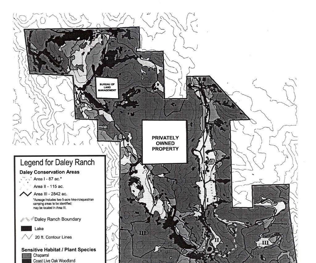
5 DALEY RANCH MASTER PLAN I. Introduction A. Vision Daley Ranch is a 3,058-acre conservation area acquired and managed in perpetuity by the City of Escondido for the preservation of a biologically unique and diverse habitat area of regional importance, while providing a variety of recreational and educational opportunities and experiences for the enjoyment of the community in a historically significant setting. B. Property Location and Physical Description 1. Location: Daley Ranch is located in the northeastern portion of the City of Escondido, north of Lake Dixon and west of Valley Center Road, as shown on Figure 1. The property defines the corporate limits of the City of Escondido on the north, east and west sides. The property is owned by the City of Escondido, and encompasses approximately 3,058 acres. Two separately-owned properties are surrounded by Daley Ranch: a 162 acre privately-owned parcel and a 40.9 acre public parcel owned by the U. S. Bureau of Land Management. Public access is provided via La Honda Drive to the south, Valley Center Road to the east, and Cougar Pass Road to the west. 2. Topography: Topography on the 1.5 mile wide, three mile long ranch is varied, with rugged, steep sloped mountain sides, gently undulating hills and level valley areas. Elevations range from 720 feet on Valley Center Road, at the property's southeast comer, to 2,135 feet on the top of Burnt Mountain in the property's northwest quadrant - the highest point within Escondido's corporate boundaries. 3. Biological Resources: Daley Ranch is home to a wide variety of sensitive, threatened and endangered plant and animal species, including over 100 species of birds. A Biological Resources Assessment for Daley Ranch (1995, Michael Brandman Associates) documented the diverse habitat communities which dominate the preserve, including Englemann Oak and Coast Live Oak woodlands, Diegan Coastal Sage Scrub, Southern Mixed Chaparral, non-native grasslands, and riparian areas. The Biological Resources Map is attached as Figure 2. Each of these habitat communities contains a variety of animal species. Oak woodlands are utilized by over 300 species of animals PL\P Rev. Sept. 1998

6 PL\P Rev. Sept. 1998
7 PL\P Rev. Sept. 1998

8 in California, including raptors (birds of prey). Englemann oak woodlands are particularly important as a sensitive and declining natural community that has been greatly reduced by development. Plant communities associated with oak woodlands include toyon, Mexican elderberry and poison oak. Diegan Coastal Sage Scrub is another threatened habitat found in several areas around the ranch. A number of rare animal species, including the San Diego homed lizard and the California gnatcatcher, live in this habitat. Chaparral is the most prominent vegetation community. Plants of this habitat are well adapted to summer drought. Common plant species of this community are charnise, mission manzanita, scrub oak black sage and ceanothus. Rock outcrops provide another important habitat, providing homes for a variety of rodents, bats and reptiles, such as lizards and snakes. Raptors use the outcrops as perching sites. Large predators such as coyotes and bobcats also use the outcrop areas as denning sites. Three year-round ponds, several seasonal ponds, and a seasonal creek provide an important water source for area wildlife. Aquatic birds such as ducks, cranes, coots and osprey can be seen in or around the ponds. The riparian habitat along the creek also support many species of wildlife that, in turn, provide a food source for larger mammals. Rock outcropping along the loop trail C. History The hills and valleys of Daley Ranch were once frequented by native Californians of the Kumeyaay and other local tribes. Evidence of their presence is found in the soot-stained ceilings of boulder caves which PL\P Rev. Sept. 1998
9 provided shelter, and in the mortars ground into the boulder tops which were used for food preparation. Numerous archaeological sites have been documented on the property to record the various cultural groups who formerly occupied the property (Gallegos and Associates, September 1992). The first European settler to arrive in the valley was an English settler named Robert Daley. He built a small log cabin in the valley in 1869, and was granted a claim to 1,600 acres of the property in The Daley family farmed the land and raised horses. In the early 1900s, the family used Daley Ranch as a dairy. The current ranch house was built around 1928, constructed out of single-board heart cedar. Related structures include a barn, former ranch house and several outbuildings used in the ranch operations. The ranch is one of the best examples of a preserved historic ranch house with related outbuildings in their original setting anywhere in the County. Redwood ranch house, constructed in the 1920s In the 1980s, plans were submitted by Mobil Oil Corporation to develop the property into one of the largest housing tracts ever constructed in North San Diego County. The proposed project, known as the Daley Ranch Specific Plan, was approved by the Escondido City Council in The project included 3,263 housing units, a golf course, country club and commercial center. The property was annexed to the City in Shea Homes Corporation subsequently acquired a controlling interest in the property, and purchased water and sewer futures from the City to guarantee rights to connect to the City's water and sewer system. The futures were sold by the City to finance improvements to the water and wastewater treatment systems, and have an escalating interest rate of 10% per year. PL\P Rev. Sept. 1998
10 A comprehensive revision to the City's General Plan was adopted in The revised General Plan reduced the allowable density for the Daley Ranch Specific Plan to 1,700 units, with additional density allowed subject to a development agreement. Shea Homes submitted a revised Specific Plan for 1,700 units, a golf course, school site and commercial center. With the economic downturn in the early 1990s, the feasibility of developing the project and constructing the necessary infrastructure became questionable, and the applicant suspended processing of the Specific Plan. Concurrently, the City Council directed staff to evaluate the feasibility of reducing the escalating debt service obligation on the sewer futures. Negotiations were initiated with Shea Homes as a major owner of the outstanding sewer rights. Assisted by the Trust for Public Lands, the negotiations were expanded to include the water rights and the potential voluntary acquisition of the Daley Ranch property. By purchasing the sewer and water rights and refinancing them at a lower interest rate, the City could save enough money to significantly offset the purchase price of the property. The acquisition was funded by the issuance of sewer bonds at a reduced rate, a payoff of the water rights from existing reserve funds, and a General Fund contribution of $2.5 million. A critical component of the acquisition process was the coordination with the California Department of Fish and Game (CDFG) and the U. S. Fish and Wildlife Service (USFWS) to establish a Conservation Bank on the property. The City had been working with these agencies on the preparation of a regional habitat and open space conservation system envisioned as part of the Multiple Habitat Conservation Program (MHCP). The Daley Ranch property had long been recognized as a key property in the development of the MHCP, due to its large undeveloped size, variety of habitat types and the opportunity for linkages to adjacent lands to create viable wildlife corridors. Through a Conservation Easement, the City agreed to preserve the majority of the property in perpetuity as an open space and conservation area, setting aside approximately 200 acres for passive park and recreation use. In return, the wildlife agencies (CDFG and USFWS) agreed that the City could establish a "conservation bank" whereby the City could sell mitigation credits to offset impacts from other development projects. The City and the wildlife agencies executed the Conservation Bank Implementation Agreement in January D. Master Plan Overview The Daley Ranch Master Plan implements a requirement of the Daley Ranch Conservation Bank Implementation Agreement. The Master Plan describes anticipated land uses, design and development criteria, and procedures for implementation. Inte11m management responsibilities defined by the Master Plan include access control measures, trail and road maintenance, enforcement, fuel management for fire prevention, habitat monitoring and reporting, habitat restoration and enhancement, and PL\P Rev. Sept. 1998
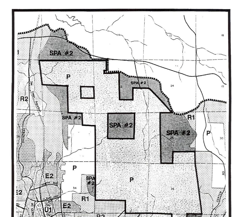
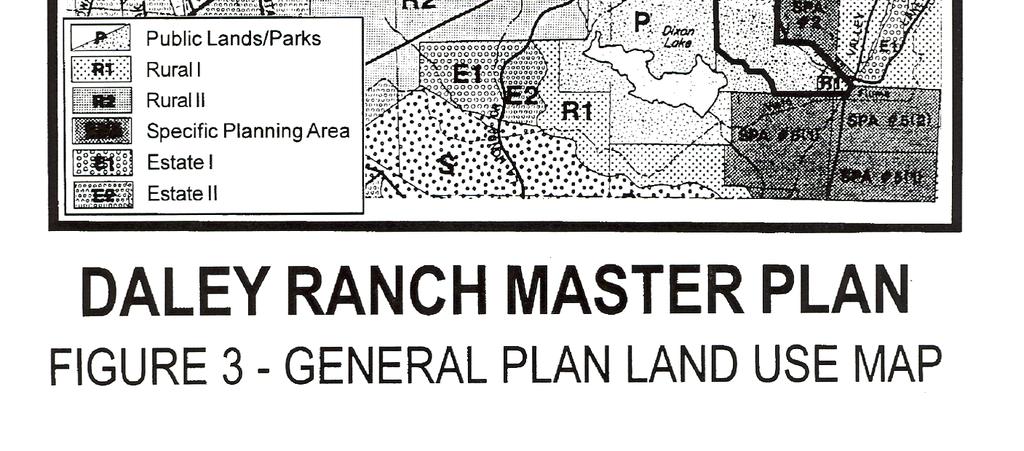
11 procedures for monitoring conservation credit transactions. A Long Term Management Plan will be prepared as part of the MHCP and City Subarea Plan. The Conservation Agreement established an Interim Management Plan for the conserved lands. The intent was to establish management requirements that would provide sufficient habitat protection while allowing limited use of the property while soliciting public input on the master plan process. Upon adoption, provisions of the City Subarea Plan will supercede the interim plan. E. Public Outreach Process A series of public meetings were held in February, 1997, to solicit public input on potential land uses and operational policies for Daley Ranch. Additionally, a public survey was widely distributed to community groups, City Boards and Commissions, and made available at City facilities. Survey topics included land use, potential conversion of the existing structures for public use, road and trail design, hours of operation, parking and access, amenities, fee alternatives, whether to allow dogs, disabled access, and access to neighboring properties. Initial feedback from the workshops and survey were used to develop the operating rules for the property, which opened to the public on April 26, Subsequent public workshops were also held with the City Council, Historic Preservation Commission, Environmental Advisory Board, and Community Services Commission to provide direction on the proposed Master Plan. Coordination with the newly formed Friends of Daley Ranch, a non-profit corporation established to help preserve and enhance Daley Ranch, was another key element in the public outreach process. The general consensus supported maintaining the property as much as possible in its natural state with minimal improvements to insure access by all members of the community. These concepts form the backbone of the Master Plan policies and implementation measures. II. Relationship to General Plan and City Policies A. General Plan Designation and Policies The City General Plan designates approximately 3,044 acres of the Daley Ranch prope11y as Public (P) land, recognizing the preservation of the property as a Conservation Bank (see Figure 3, General Plan Land Use Map). The Public land use designation includes large, publicly owned properties, including prevalent open spaces and public parks. Approximately 14 acres along Valley Center Road are not included in the Conservation Bank, and are designated as Rural I (RI), a low density PL\P Rev. Sept. 1998
12 PL\P Rev. Sept. 1998
13 residential designation which allows up to one dwelling unit per four acres. These 14 acres are not a part of the Master Plan. The General Plan establishes a Quality of Life Standard for Parks and Open Space. The standard for parks establishes a minimum of 2.25 acres of developed, active neighborhood and community parks in addition to 2.25 acres of passive park land and open space, totaling 4.5 active and passive acres per 1,000 residents. The acquisition of Daley Ranch represents a significant contribution towards the City's implementation of the Quality of Life Standard for passive park and open space lands. Additionally, Daley Ranch is a significant contribution to the system of open space and trails, providing over 3,000 acres of open space and approximately 20 miles of trails to the system. The General Plan Community Open Space and Conservation Element establishes policies for the development of a comprehensive open space system and for protection of Escondido's natural assets. These policies include the preservation of natural drainageways and steep slopes as permanent open space, the protection of rare, threatened and endangered plant and animal communities, development restrictions on ridgelines, and the establishment of a system of open space corridors and trails. The Daley Ranch Conservation Bank and Master Plan are consistent with these policies, and provide management and monitoring procedures to insure the long-term implementation of these policies. B. Zoning The Daley Ranch Conservation Bank property is zoned Open Space (OS). This zone designates land for public uses related to open space, recreation, education and public facilities, and land requiring protection due to unique scenic, geologic or biological value. The Master Plan allows a variety of active and passive recreational uses consistent with the OS zone and provides further restrictions to insure compatibility with the intent of the Conservation Agreement. C. Parks, Trails and Open Space Master Plan 1. Conformance with the Master Plan: The Parks, Trails and Open Space Master Plan furthers the goals and policies of the General Plan and implements the Quality of Life Standard for Parks and Open Space, as described in Section II.A above. The plan identifies where development and open space are appropriate, identifies conceptual open space corridors for preservation of natural habitat, and integrates the open space system with a network of parks and trails for public access. The acquisition of Daley Ranch was not anticipated at the time of the Parks, Trails and Open Space Master Plan. The Daley Ranch Conservation PL\P Rev. Sept. 1998
14 Bank ensures that the property's natural resources will be managed in such a way as to further implement these components of the Parks, Trails and Open Space Master Plan. The Parks, Trails and Open Space Master Plan designates two types of rural trails on Daley Ranch. Rural Regional Collector Trails are anticipated to connect the San Dieguito River Park to the City of San Marcos trail system. At Daley Ranch, this trail segment connects Valley Center Road to Cougar Pass Road. Secondary Local Rural Trails are located in more rugged, less developed areas of the community. In the vicinity of Daley Ranch, these trails are anticipated along the perimeter of the property, as well as an east - west connection through Daley Ranch. The existing trail system at Daley Ranch is consistent with the Master Plan of Trails exhibit, which anticipates earthen trails which vary in width from seven to eleven feet for multi-use trails, and four feet wide for pedestrian trails. Trail features may include focal points, signage, and trail elements such as bicycle racks, picnic tables, trash receptacles and seating at viewpoints in selected areas 2. Relationship to Dixon Lake: Daley Ranch is immediately north of Lake Dixon and has its primary public entry off La Honda Drive, as does Lake Dixon. Due to this close proximity, the two sites can share public parking lots. One of the Daley Ranch trails, the Chaparral Loop Trail, can be easily accessed from the northeastern Lake Dixon parking lot. Since Lake Dixon has developed picnic areas, playgrounds, fishing and boating, a concession stand and overnight recreational vehicle camping, it is a good complement to Daley Ranch. There will be no need to duplicate these activities at Daley Ranch. The continuity of the open space is extremely valuable, since Lake Dixon and Daley Ranch support a large variety of birds and animals. Although Lake Dixon does not allow equestrian activities on site, the hiking and biking trails of Lake Dixon and Daley Ranch are tied to together, creating a trail system with a wide variety of experiences. The existing Park Ranger staff at Lake Dixon has been expanded so that they can oversee the activities at Daley Ranch as well. The Daley Ranch caretaker reports to the Lake Dixon supervisor. D. Relationship to the Multiple Habitat Conservation Plan and Subarea Plan The Multiple Habitat Conservation Program (MHCP) is a regional, comprehensive habitat process that addresses multiple species needs and the preservation of native vegetation communities for seven cities within north San Diego County, including the City of Escondido. The MHCP is one of three subregional plans proposed in the San Diego region under the Natural Communities Conservation Planning Act, and will be PL\P Rev. Sept. 1998
15 implemented through individual subarea plans prepared by each local jurisdiction. The intent of the MHCP and related programs is to develop a coordinated habitat preserve system to preserve biodiversity. The Daley Ranch Conservation Bank is a critical component of the City's proposed Subarea Plan and Focused Planning Area. With the conservation of over 2,800 acres in a conservation bank, Daley Ranch contributes approximately 45% of the City's proposed preserve system, and approximately 14% of the targeted conservation area for the MHCP. A required element of the City's MHCP Subarea Plan will be a long-term management plan for preserved lands. This plan would prioritize management activities, identify what habitat monitoring would occur, address fire management planning, and other issues. The wildlife agencies agreed that the long-term management plan for Daley Ranch should be integrated into the City's Subarea Plan. Additionally, mitigation requirements for impacts created by enacting parts of the Master Plan will be consistent with the Subarea Plan's mitigation policies and procedures when adopted. E. Conservation Easement and Conservation Bank The Daley Ranch Conservation Bank is established by a conservation easement and implementation agreement approved by the California Department of Fish and Game (CDFG) and the U. S. Fish and Wildlife Service (USFWS). The property is owned and managed by the City of Escondido, with an easement granted to the California Department of Fish and Game for conservation purposes. The agreement allows the City to sell credits from the conservation bank for mitigation purposes, to offset the impacts from development projects within Cismontane San Diego County. Of the total 2,842 conservation credits, 200 credits have been allocated to Shea Homes as pmt of the purchase agreement. The initial distribution of the credits is as follows: Coast Live Oak Woodland Englemann Oak Woodland Chaparral and Coastal Sage Scrub Water dependent Habitats Non-native Grassland and Other 156 credits 84 credits 2,252 credits 18 credits 332 credits The City is required to report all credit sales transactions to CDFG and USFWS, along with an annual report tracking the cumulative sales. Additionally, separate financial accounts have been established to track contributions to an endowment fund and a restoration fund, intended to insure that adequate funds are available over time for the long-term management and monitoring of the property. PL\P Rev. Sept. 1998
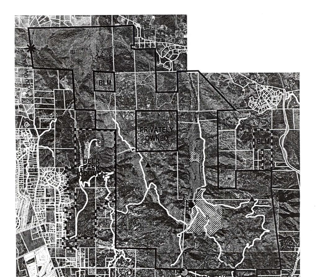
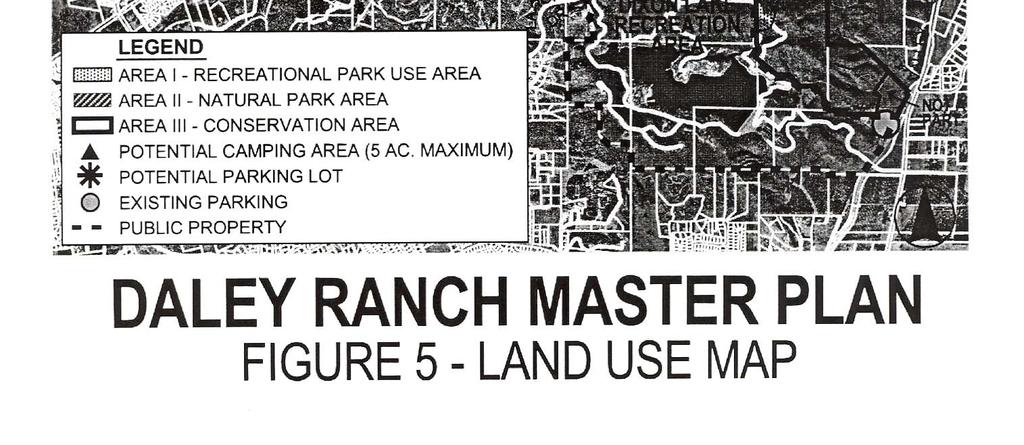
16 III. Land Use and Design A. Land Use Policies 1. Land uses and activities at Daley Ranch shall balance the longterm management of the property as a conservation area with the community's interest in providing a variety of compatible recreational uses and experiences. Proposed uses and activities shall be consistent with Appendix I and shall be monitored to insure the habitat value of the property is maintained. 2. Proposed uses shall be designed to minimize removal of habitat and retain existing trees to the extent feasible. 3. Priority in the early phases should be given to low intensity recreational uses, and environmental protection and interpretation. 4. Future improvements should be evaluated to insure that the site features of historic and architectural significance are preserved to the extent feasible while providing opportunity for public access, or maintained in a state of sustained decay. Particular attention should be given to preservation and public use opportunities for the ranch house as an interpretive center or museum. 5. Caretakers quarters should be maintained on-site to provide 24- hour supervision and security. 6. The City should work cooperatively with the Friends of Daley Ranch, schools and educational institutions and public service groups to expand educational opportunities within Daley Ranch. 7. Concessionaire potentials within Daley Ranch should be carefully controlled to provide activities compatible with the intent of the property as a conservation area. 8. Work with property owners of adjacent properties to accommodate the development of compatible land uses, such as recreational, educational and low-intensity tourist-oriented uses, with appropriate buffers and access controls and preservation of public trailheads. 9. Work with the Bureau of Land Management and other public agencies to evaluate opportunities to consolidate maintenance responsibilities and preservation opportunities on adjacent public properties. 10. Provide a primitive camping experience distinct from the type of camping available at Lake Dixon, with amenities limited to basic PL\P Rev. Sept. 1998
17 sanitation and trash disposal facilities and subject to a permitting procedure. Equestrian camping should be separated from other walk-in camping areas. 11. The City shall maintain existing property line fencing. Additional new property line fencing shall only be added on an "as needed" basis to control access and egress. There is no plan to fully fence the site. 12. Signs will be posted at all public access points to advise the public that Daley Ranch is publicly owned and available for their use. A rules and regulations sign will also be posted at all public access points. A brochure with site history, rules and regulations and trail maps will be available at each entry point. 13. New accessory structures and amenities such as trail signs, interpretive kiosks and picnic tables should be consistent with the rustic character of the existing ranch structures, with an emphasis on natural and painted wood or use of materials that have a wooden appearance. B. Land Use Areas The Conservation Agreement establishes three distinct land use areas within Daley Ranch as described below and as shown on Figure 4 - Area Map and Figure 5 - Land Use Map. Allowable land uses for each area are outlined in the Land Use Compatibility Matrix, attached as Appendix 1. Specific uses currently anticipated for each area are described below. Other uses not proposed but permitted by the matrix may be considered at a future date, subject to environmental review and notification or consultation with the wildlife agencies as appropriate. 1. Area I (Recreational Park Use Area) This 87-acre area is intended for active park and recreational uses and associated public facilities that are compatible with adjacent natural and conservation areas. This area generally includes a portion of the central valley in the vicinity of the ranch house, barn and outbuildings and along the project entries. Specific uses anticipated at various locations within Area I are described below: a. Entry service road from La Honda Drive - The existing foot wide road is deemed adequate for use by City maintenance vehicles and shuttle service. Use by private vehicles will not be allowed since improvements to accommodate two-way traffic would necessitate widening to a minimum of 20 feet paved surface area, and would result in grading and habitat removal. PL\P Rev. Sept. 1998

18 PL\P Rev. Sept. 1998
19 PL\P Rev. Sept. 1998

20 b. Two disturbed areas east of the service road (approximately halfway to the ranch house) - These areas were evaluated as potential future parking areas. However interior public parking was determined to be inappropriate, and the parking sites have been deleted. No specific uses are currently envisioned for this area. c. Ranch house area - The existing ranch house and outbuildings are located approximately 1.5 miles from the La Honda Drive entry, and function as the destination point for most visitors. The location is ideal for picnicking and interpretive displays, and also serves as a trailhead for many of the ranch trails. Future conversion of the ranch house to an interpretive center or museum is anticipated, pending a structural and architectural evaluation of existing buildings. Replacement caretakers quarters in the vicinity of the ranch house are also envisioned. As the most active use area, this location provides an opportunity for concessions, such as limited food and beverage sales and rental of recreational equipment. Concessions shall generally be located in the vicinity of the ranch house. Proposed concessions will be reviewed by the City Community Services Department and forwarded to the City Council as deemed appropriate. d. Two areas adjacent to the Lake Dixon access road - Existing trails at this location link Daley Ranch to Lake Dixon. These areas were originally envisioned as potential parking and equestrian staging areas serving both Lake Dixon and Daley Ranch; however these uses are not deemed necessary and are not proposed. Acreage within this area is proposed to be traded for an equivalent amount of acreage in Area III along Cougar Pass Road to allow future construction of a parking lot at the Cougar Pass Road entry. Redwood barn and picnic area PL\P Rev. Sept. 1998


21 2. Area II (Natural Park Area) Year-round pond and island in Area II This 115-acre area is intended to provide limited low intensity recreational opportunities in confined locations which are compatible with and maintain the natural character and habitat value of the surrounding property. Area II is located in two general areas, north and southeast of the Area I ranch house vicinity. The key site features in this area are the ponds located in the southeast portion, which provide ideal habitat for migrating birds. Primary uses in this area will be trail use, interpretive displays and habitat viewing areas, particularly overlooking the pond areas. Area II could revert to Area III with associated conservation bank credits at some future date, subject to approval by the wildlife agencies. 3. Area III (Conservation Area) Proposed camping area in Area III PL\P Rev. Sept. 1998
22 This 2,842-acre area is intended as an open space and habitat conservation area with limited public access for passive recreational uses along established roads and trails. All acreage within this area is included in the conservation bank in accordance with State and Federal resource protection policies. Two potential primitive five-acre camping sites have been identified on the Land Use Map (Figure 5), located in the east and central portions of Area III in areas subject to previous disturbance. Camping will be limited to walk-in, bicycle and equestrian access only, subject to a permit from the Community Services Department and generally limited to individuals or groups of no more than twenty people. Amenities will be limited to sanitation and trash disposal facilities and minor accessory structures, such as picnic tables and hitching posts. 4. Not a Part Area Approximately 14 acres along Valley Center Road are not included in the Conservation Bank. This property is regulated by the existing General Plan designation of Rural I (RI), which allows low density residential uses up to one dwelling unit per four acres. Future development on this site shall be evaluated to insure that a trailhead and adequate public access to the Valley Center Road parking area is maintained. IV. Access and Circulation A. Access and Circulation Policies 1. Public or private access through Daley Ranch to serve private property shall generally not be allowed unless otherwise established by entitlements granted prior to the establishment of the Conservation Bank. Limited encroachments such as access easements at the perimeter of Daley Ranch may be allowable to avoid extensive grading, habitat removal or visual impact, subject to City and wildlife agency approval on a case-by-case basis. 2. Monitor development applications for adjacent properties to insure that adequate emergency access from Daley Ranch, as well as access to public parking and trailheads at the Daley Ranch perimeter, is maintained. 3. On-site road and trail improvements should minimize grading and habitat removal, and be constructed of the minimum width and surfacing to accommodate safe vehicular and emergency access. Interior roads are intended for use by authorized maintenance and emergency vehicles and shuttle services only. Private vehicles are PL\P Rev. Sept. 1998
23 B. Roads prohibited within Daley Ranch, except as authorized by special arrangement with the City park rangers. 4. Encourage the use of alternative means of access such as a shuttle service, to maximize access by all members of the community while minimizing conflicts between vehicles and trail users and reducing potential disturbance of habitat areas by private vehicles. 5. Continually evaluate the accessibility of Daley Ranch to insure that all members of the community have an opportunity to enjoy the variety of experiences available. Monitor shuttle utilization and demand. 6. Concentrate parking areas at public entry points along La Honda Drive, Valley Center Road and Cougar Pass Road, and encourage equestrians with trailers to park at the Valley Center Road equestrian center. 7. On a case by case basis, consider individual requests for special access controls and gates for abutting private properties, where proposed land uses are compatible with the conservation bank. 8. Monitor trail use to determine whether refinements to the multiuse trail policy and use regulations are warranted. 9. Encourage cooperation with owners of existing utility easements to minimize disturbance caused by maintenance activities. 10. Public entries shall be managed and gated to control unauthorized vehicular access. Offsite: As shown on Figure 6 - Circulation and Trails Map, Daley Ranch has access from three public roads. La Honda Drive provides the main access point on the south; this two-lane paved road also provides access to Lake Dixon. La Honda Drive is narrow and winding, and has no sidewalks. Any proposed intensification of use at Daley Ranch will warrant a traffic study to determine the need for additional road improvements. Cougar Pass Road is an unpaved road that actually comes onto the ranch in the very northwest comer of the site; most of Cougar Pass Road is within the County. A small portion of the ranch property also abuts Valley Center Road on the southeast comer of the site. Since the existing flood control channel provides a physical barrier separating Valley Center Road PL\P Rev. Sept. 1998
24 PL\P Rev. Sept. 1998
25 from the rest of the Daley Ranch property, direct access is provided across the City-owned Dixon Lake property immediately adjacent to the south. No other Circulation Element Roads serving the ranch are anticipated by the General Plan Circulation Element. Several properties abutting Daley Ranch have existing private roads and driveways that lead up to or near the Daley Ranch property line. Such locations are not considered public access points. Due to topographical constraints, future development of abutting properties may propose minor encroachments at the extreme borders of Daley Ranch for the construction of access roads in order to minimize grading impacts. Such requests will be negotiated on a case-by-case basis with the City, upon consultation with CDFG and USFWS, with the resulting road easement area, associated graded slopes, and acreage between the road and private property removed from the available Conservation Bank credits. Onsite: All roads on the ranch were built to serve the ranch activities and do not meet today's standards for public roads. These roads have natural material surfaces and are typically foot in width. There are approximately 20 miles of this type of road on Daley Ranch. These roads also serve as the recreational use trails. The main road between La Honda Drive and the ranch house is the only road that has any type of surfacing, consisting of some type of compacted material that has been oiled. The width of this road varies from 20 feet wide to as little as 12 foot wide where it goes through an oak woodland and wetlands area. The distance from the main gate to the ranch house is approximately 1.5 miles. All public and emergency access points are depicted on Figure 6 - Circulation and Trails Map. The conservation agreement allows existing roads to remain, and allows new roads to be constructed upon consultation with the wildlife agencies. As currently constructed, the main road between the ranch house and La Honda Drive is suitable for use by maintenance vehicles and shuttle service. Access by private vehicles is not allowed due to the narrow width, need for enforcement and control measures to protect sensitive areas, and potential conflicts with recreational trail use. To maintain the biological value and character of the property as a conservation area, visitors will park outside Daley Ranch. Limited access by private vehicles may be permitted by special arrangement to accommodate special needs. Shuttle service is provided on a limited basis to facilitate access to the ranch house area. Shuttle utilization will be monitored to determine the demand for increased service or alternative vehicular access. The Master Plan will be reviewed every five years, and at such time as the ranch house is made available for public use, to determine whether additional road improvements are needed. Appropriate mitigation will be required in PL\P Rev. Sept. 1998

26 C. Trails accordance with recommendations of the wildlife agencies. The City anticipates using credits from the Daley Ranch Conservation Bank for mitigation, should the road improvements affecting biological resources be constructed. The park rangers and the caretaker will monitor the condition of all roads and trails on a monthly basis. On an annual basis, the City's Public Works Department staff will inspect the condition of all roads and trails. Repair work will be scheduled, as conditions require. The majority of the repair work will be done by City staff, but it is the City's intent to utilize volunteers to do various trail maintenance projects that require only hand labor. These projects will vary from repair of eroded areas to cutting back overgrown vegetation along the trails. In all cases, this work will be done under the supervision of a park ranger. Repair work involving reconfiguration and regrading of trails will require consultation with the City Planning Division to insure that biological and archaeological resources are not negatively affected. The existing trails on Daley Ranch vary from the 12-foot wide multipurpose service roads to single track trails. Presently there are seven trails that have been named and marked. Most of these are loops that bring the user back to the starting point. The trails range from 1.4 miles up to 5.5 miles. They provide a wide variety of experiences since there are significant changes in elevation on most trails. All trails are designated as multi-use and are posted with the international yield signs. Additional existing trails are proposed to remain as shown on Figure 6 - Circulation Trail through the Central Valley PL\P Rev. Sept. 1998
27 and Trails Map. Only trails that are mapped and provided with visible trail markers or signs are intended for public use. To prevent visitors from using other secondary trails which are not intended or maintained for public access, a physical barrier such as a split rail fence or planting of thorny vegetation may be installed, to allow such unmaintained trails to revegetate naturally. Signs may be posted when necessary to discourage use of unmaintained trails. The Master Plan does not propose to construct any new trails except for a short section on the Caballo Trail. This trail has a very steep section that is difficult for horses to use safely. Since this trail has an excellent public parking lot located off Valley Center Road that can accommodate trucks and horse trailers, it is desirable to improve this trail. It is anticipated that about 1,650 feet of new trail that is four feet wide would be cut into the existing chaparral vegetation. The trail will be constructed under the supervision of the park rangers to minimize slope heights and vegetation removal. Appropriate mitigation would be provided by utilization of credits from the Daley Ranch Conservation Bank. D. Emergency Access Daley Ranch has four points of public access; these include access from the three public roads as well as access from the northeastern Lake Dixon parking lot. In addition, there are a number of access points onto adjacent private property that can be used in emergencies, as shown on Exhibit 6 - Circulation and Trails Map. These occur on the west, north and east sides of the ranch. The service roads within the ranch provide access to these points and there are locked gates at the property line to control unauthorized access. All agencies that may have a need to drive emergency vehicles through these gates have been given keys to the locks. E. Utility Easements The San Diego Gas and Electric Company (SDG&E) has an existing easement on the Daley Ranch property. The easement provides them with access rights to maintain the poles and overhead electric lines as well as the underground high-pressure gas main. These utilities generally run in a north - south direction through the site. SDG&E routinely inspects their equipment. Maintenance responsibilities include some minor grading of roads to access the equipment. F. Access to Adjacent Properties The Daley Ranch property line is fenced in critical areas only. The total boundary has never been fenced and there is no expectation that this will be required in the future. Chain link or other wire type fencing has been installed in areas where access needs to be controlled. Gates have been PL\P Rev. Sept. 1998
28 installed so that emergency vehicles can either access or egress the property. Adjacent property owners have indicated a desire to keep recreational users off their property. Posted public access points to Daley Ranch have been limited to those areas where the ranch abuts a public road or other public property. There are two parcels that are totally surrounded by Daley Ranch that are not owned by the City. The Federal Bureau of Land Management (BLM) owns one parcel and a private individual owns the other. At this time there are no plans to provide public access to either property. The BLM parcel is designated for protective disposal under the Recreational and Public Purposes Act (RPP A). Disposal of this parcel to a public agency for public recreational purposes is consistent with the RPP A. The City has initiated discussions with BLM regarding potential acquisition of this landlocked parcel to complement the conservation bank and consolidate maintenance responsibilities. G. Parking When the ranch was opened to public use in April 1997, there were three existing off-site parking lots designated for public use. These were located on La Honda Drive outside the main gate; along the primitive road at Lake Dixon; and at the Charros arena off Valley Center Road. These have been able to generally serve the public except for peak periods when there is also heavy demand for parking at Lake Dixon. To accommodate equestrians, there is also a need for more horse trailer parking, due to the large amount of space needed to maneuver, park and unload horse trailers. This can be met by directing equestrian users to the Caballo trailhead. There is plenty of parking at this location, but the trail itself needs to be modified to make it more usable for equestrians. As part of the Master Plan process, opportunities for new public parking areas within the Daley Ranch property were evaluated. Four sites were identified as potentially suitable due to the flat topography and disturbed vegetation in these areas, including three interior sites and one area along Cougar Pass Road. Two sites were located in disturbed chaparral areas along the road between the main gate and the ranch house. Another new lot could be located in the vicinity of the ranch house. None of these interior parking areas are currently proposed, as private vehicles are not allowed within the ranch. A fourth site for a parking lot is located on the west side of Cougar Pass Road. Although this lot is in a designated Area III (Conservation Area) location, the site has been disturbed in the past, and is mostly annual grasses surrounded by oak woodlands. This site can accommodate approximately 27 cars. It is anticipated that this lot would need to be designed to serve both cars and trucks with horse trailers. This new lot could provide much-improved public access to the north portion of the ranch. Since this site is in Area III, approval would be needed from the PL\P Rev. Sept. 1998
29 wildlife agencies and Daley Ranch bank credits would be used to provide appropriate mitigation. An equivalent amount of acreage from Area I at the eastern end of Lake Dixon Road could be substituted for the acreage needed for the Cougar Pass parking lot to maintain the amount of credits established by the conservation agreement. By allowing the acreage transfer, the buffer area around the seasonal pond will be increased. Any new parking area will be designed by a City Engineering Division staff member and approved by the City Engineer. It will also be reviewed and approved by the Director of Planning and Building for conformance with the Conservation Bank Agreement. Anticipated improvements would be minimal, consistent with the overflow parking lot at Lake Dixon. Typical parking lot improvements would be compacted base material or asphalt paving and gated entries, with no lighting. Maintenance of all parking areas will be the responsibility of the City Public Works Department. A Public Works Department representative will make an annual inspection of parking lot conditions. H. Access for Persons with Disabilities The Americans with Disabilities Act (ADA) contains regulations that apply to "buildings", including the ranch house; however, there are currently no federal ADA regulations for "park or recreational" type facilities, referred to as "outdoor developed areas", at the federal level. These regulations are currently being formulated in a committee of the federal Architectural and Transportation Barriers Compliance Board, with implementation being at least a year away. There are however, disabled access regulations for outdoor facilities currently in effect at the state level. In general, the regulations require access as noted below: Campsites - accessibility for a portion of the facilities Picnic areas, day use areas, vista points - must be accessible. Sanitary facilities - must be accessible to those public-use areas that are accessible. Parking lots - must be provided with accessible parking spaces with access to adjacent paths, walks or trails. Trails, paths and nature walk areas or portions of these, must be constructed with gradients to permit at least partial use by wheelchair occupants. Hard surface paths or walks must be provided to serve buildings and other functional areas. Nature trails and similar educational and informational areas must be accessible to the blind by the provision of rope guidelines, raised Arabic numerals and symbols for identification, information signs, and related guide and assistance devices. PL\P Rev. Sept. 1998
30 The Master Plan anticipates conversion of the ranch from its present use as Living quarters for the caretaker to some type of public use, such as an interpretive center or museum. Before this can take place, a number of modifications and improvements will need to be made to the structure. Since the house may be designated as a historical landmark, the specific modifications are not known at this time. As part of the Master Plan implementation, the city intends to hire an architect or structural engineer to evaluate the existing facility and to make recommendations on how to upgrade it with the least negative impact on its historical condition. The Historic Preservation Commission and Friends of Daley Ranch will assist in this evaluation. Additionally, this evaluation is also intended to identify the site's key features and viewpoints that can be modified or improved to provide full accessibility. V. Infrastructure A. Infrastructure Policies B. Water 1. Future extensions of water and sewer facilities are not currently proposed to serve land uses anticipated by the Master Plan. Potential improvements such as a caretaker's quarters are anticipated to be served by a septic system. 2. Future uses allowed by the Conservation Agreement but not currently proposed will require subsequent analysis to evaluate the potential need for service expansions or modifications, and may warrant subsequent environmental review. 3. Opportunities to improve communications for emergency services should be evaluated. The ranch has no service from a public water district. There are several wells on the site. The only active well is near the ranch house, providing water to the ranch house and the surrounding landscape. Although the water meets the standards of potable water, it has a "funny" taste. The caretaker uses bottled water to drink and cook. There are no plans to provide potable water for the public from this well. If needed, bottled water will be set up at appropriate locations on an "as needed" basis. Potable water is available at the Caballo trailhead and Lake Dixon. PL\P Rev. Sept. 1998
31 C. Sewage There are no public sewer lines on the ranch. The ranch house has a septic system. This system was repaired during the spring of 1997 and should be in good condition at this time. If it is determined that a new caretakers house should be built, it will need a separate septic system. D. Utilities The ranch house is heated with natural gas from SDG&E. The electrical service is also from SDG&E. There is telephone service to the caretakers quarters and a public pay phone is available near the ranch house. VI. Management A. General Oversight The Public Works Department, Lakes Division will have management responsibility for day to day activities. Funds for annual operation and maintenance expenses are included in the Lakes Division budget. The fiscal year budget is $80,000. The fiscal year is from July 1 to June 30. The Lakes Division is also responsible for Lake Dixon and the park ranger program. Lake Dixon has staff on site 24 hours per day, seven days per week. The ranch caretaker reports to the Lakes Supervisor. The caretaker will be on site 24 hours per day, except Saturdays. The caretaker is responsible for patrolling the site on a daily basis. The caretaker checks all access points to verify gates are locked and no unauthorized vehicles are on site. He is available to answer questions from the public and to assist them in properly using the site. The caretaker verifies that no unauthorized uses are taking place. Daily maintenance of the ranch house and the surrounding landscape is also done by the caretaker. Park rangers are available from Dixon Lake on an "as needed" basis. The rangers are scheduled to patrol Daley Ranch on weekends, holidays or during special events. A Volunteer Patrol has been organized. Approximately 35 people went through the training program and are scheduled to patrol mostly on weekends and holidays. B. Habitat Monitoring The City will prepare a habitat monitoring report on an annual basis or as otherwise required by the City's MHCP Subarea Plan. The monitoring will be done by qualified professional personnel. The report will be given to the City Council and will be available for public review and comment. The city intends to involve and utilize the talents of volunteers whenever PL\P Rev. Sept. 1998

32 possible. A number of groups and organizations have indicated a willingness to participate in this activity. The methodology will include a field inspection along existing trails, a review and comparison of baseline conditions contained in the 1995 Biological Resources Assessment, and a letter report documenting observations and recommendations. Findings shall be mapped in the report. The report shall be transmitted to the wildlife agencies by April for the prior calendar year. Area III Conservation area, looking east C. Habitat Restoration The Conservation Agreement establishes a restoration Fund, to be funded by sales of conservation credits. The agreement obligates the City to perform habitat restoration in areas where degradation has occurred due to poor management oversight. While not required by the agreement, other opportunities exist for habitat restoration. These include enhancement of wetlands, and reintroduction of native species to replace the grasslands along the central valley. Implementation of such voluntary programs would likely come from volunteer resources and funded by sources other than the City. Controlled bums in selected areas may be another tool to enhance habitat restoration; however this method appears to have limited potential due to the proximity of surrounding land uses. D. Trail Maintenance Trails are routinely inspected by the parks rangers and caretaker as part of their daily patrols. Trail maintenance will primarily focus on the minimum corrective measures needed to maintain adequate emergency access, control erosion and prevent habitat degradation. PL\P Rev. Sept. 1998
33 E. Invasive Plant Removal Program Although there are not a lot of exotic plants on site at this time, it is the intent of the city to closely monitor this type of plant material so that it does not get out of hand. The city will also implement an invasive plant material removal program (see Appendix 3 - Exotic Plant Control Program). Again, qualified professionals will lead volunteers in the actual work program. It is anticipated that this can be accomplished with a once per spring and once per fall effort. F. Predator Control No predator control measures are proposed. G. Security Site security is generally provided by the on-site caretaker and random patrols by the park rangers. Due to the remoteness of the ranch house, it appears that there will always be a need for an on-site caretaker. If the existing ranch house is converted to some other public use, a replacement caretaker's home should be constructed in the general area of the existing ranch house. Additional security will be provided by the Volunteer Patrol, utilizing the services of volunteers trained by the City to assist in the enforcement of operational rules. Park rangers have the authority to write citations for rules violations. The ranch is within the city limits of the City of Escondido. Therefore it is the responsibility of the Escondido Police Department to respond to any emergencies. H. Brush Management and Fire Protection The Escondido Fire Department will monitor the site for any fire hazards. The Fire Chief has identified which existing roads need to be kept to provide emergency service. In order to effectively fight a fire and to protect the firemen and equipment involved, adequate clearance area is needed for equipment staging and vehicle maneuvering. The Fire Chief has determined that it will be necessary to keep the vegetation along the roads cut back approximately 15 feet on either side of the road in selected areas, as identified on Figure 7 - Brush Removal Plan. This will not be possible in some areas due to the adjacent slopes and type of vegetation. Therefore, this will be accomplished by mowing the vegetation in the flat, grassy areas and by pruning trees within this clearance area to allow a foot high vertical clearance. Vegetation types that will most likely be impacted are coastal sage scrub, chaparral and grasslands. Oak woodlands and riparian areas will not be affected. PL\P Rev. Sept. 1998

34 PL\P Rev. Sept. 1998
35 The brush removal plan generally reflects historical clearing and mowing activities conducted by the previous owner and easement holders. The central valley loop has been historically mowed by SDG&E to maintain access to their equipment. The mowing in the western area also reflects a historic agreement between the City and previous property owner to maintain certain roads. The Fire Department anticipates the need to mow designated areas annually, and will coordinate the timing of mowing operations with the wildlife agencies to minimize disturbance to wildlife and plants. Controlled bums are not anticipated as a fire protection measure, although such actions may have limited application as a habitat restoration measure. VII. Financing A. Acquisition Costs and Financing As described in Section I.e., the City purchased the water and sewer rights from Shea Homes at present value (1997) to prevent further escalation at a high interest rate, and issued bonds to finance the purchase at a lower interest rate, thereby incurring a significant present value savings. The total payment for the acquisition was $21 million. This included the sewer bond refinancing ($14.28 million), water bond acquisition ($4.22 million), and the $2.5 million balance attributable to the land value. B. Improvement Costs Capital improvements anticipated as part of the Master Plan implementation are limited in scope. These include the following: Modifications to the ranch house and other existing structures for public use Construction of caretakers quarters Incidental structures, such as signs, information kiosks and shade structures Improvements to accommodate persons with disabilities Parking areas and associated road improvements. Such improvements are anticipated to be accomplished incrementally as funding becomes available. C. Operation and Maintenance Costs The City of Escondido is responsible for ongoing operation and maintenance costs. These responsibilities include enforcement and security, brush removal activities for fire prevention, habitat restoration of degraded areas, and annual biological monitoring responsibilities as PL\P Rev. Sept. 1998
36 established by the Conservation Agreement. These responsibilities will be accomplished through a combination of staff and volunteer resources, General Fund revenue (not to exceed $80,000 per year), and Endowment and Restoration Funds set aside by the sale of conservation credits. Additional operational costs would be incurred with continued and expanded operation of the shuttle service. D. Potential Funding Sources 1. Non-profit Corporation - A non-profit 501 (c) (3) corporation, the Friends of Daley Ranch, has been established for charitable and educational purposes to benefit Daley Ranch. Specifically, the purposes of the corporation include the preservation and enhancement of Daley Ranch and surrounding lands and resources for scientific, educational, historical, cultural, recreational, ecological, scenic and open space purposes; and the establishment and operation of preservation, restoration and enhancement programs. While the City will retain land use authority regarding all proposed activity on Daley Ranch, the Friends of Daley Ranch may assist the City in accomplishing and expediting the improvements and programs anticipated by the Master Plan. The City will work cooperatively with the Friends of Daley Ranch regarding future improvements and activities, including consultation and staff assistance upon request. 2. Grants - Grant funding provides an additional opportunity to finance improvements and programs at Daley Ranch. City staff will monitor available grant programs and seek City Council direction to pursue grant applications when appropriate. 3. User Fees - User fees represent a revenue generating opportunity for Daley Ranch. Typical user fees could include parking fees, entrance fees, fees for special activities such as camping, horseback riding, shuttle service and concessions. Such fees require a method of collection and enforcement. The City Council establishes policies regarding user fees and concessions. No fees are proposed at this time, and the Master Plan implementation does not rely upon the collection of user fees. 4. Conservation Bank Revenue - The Conservation Agreement establishes the authority for the City to sell conservation credits. The City Council retains sole authority to determine the credit sales price. Per the agreement, sales revenue in excess of the amount set aside for the Endowment and Restoration funds may be used by the City at the discretion of the City Council. PL\P Rev. Sept. 1998
37 5. MHCP Regional Funding - A Financing Plan will be required as part of the MHCP and City Subarea Plan; components of the Financing Plan will include a regional strategy for acquisition, management and biological monitoring. While the acquisition and management responsibilities for Daley Ranch did not rely upon anticipated reimbursement from the MHCP, Daley Ranch functions as a critical contribution to the regional habitat conservation effort. As such, consideration of potential reimbursement strategies as part of the MHCP financing plan may be warranted. E. Conservation Bank Transactions The City Planning Division is responsible for tracking all Conservation Bank transactions including notification to the wildlife agencies, recording the number and type of credits sold, the allocation of sales revenue to the appropriate account, and preparation of a ledger system to track and report credit sales. The Finance Department has established separate accounts to track revenue in the Endowment and Restoration Funds. Expenditures from these funds are governed by the Conservation Agreement and require authorization in accordance with City administrative procedures. VIII. Implementation The Master Plan is anticipated as a feasible concept with possible directions for City policy - not as a precisely designed plan that needs to be fully implemented in a few years. Specific land use proposals, improvements and requests for special activities shall be reviewed for consistency with the Master Plan and Conservation Agreement, and may require subsequent environmental review. The Master Plan should be reviewed every five years to update the Master Plan as necessary. A. Use Interpretations and Agency Coordination Proposed land uses and activities shall be consistent with the Land Use Compatibility Matrix (Appendix 1) as determined by the Director of Planning and Building ("Director"). Uses not specifically identified in the matrix but which are consistent with permitted uses may be allowable subject to a Statement of Compatibility determination from the wildlife agencies (CDFG and USFWS), as outlined in the matrix. The Director may consult with City Boards and Commissions, the Friends of Daley Ranch, or other advisory group prior to a determination, and may forward specific requests to the City Council. PL\P Rev. Sept. 1998
38 B. Environmental Review Proposed uses, activities and improvements to implement the Master Plan shall require environmental review. Direct impacts to biological resources shall be mitigated in accordance with recommendations of the wildlife agencies or as subsequently modified by the MHCP and City Subarea Plan, and consistent with the "no net loss" policy for wetlands. The Master Plan anticipates that credits from the Daley Ranch Bank will be utilized as mitigation. C. Special Events Special events may include activities such as organized hikes, bicycle tours, group horseback riding and athletic events. Special events are coordinated through the Community Services Department upon consultation with the Planning Division to determine consistency with the Conservation Agreement. Requests that affect the general public use of the property, such as closure of trails for a specified use, shall require a facility use permit and provide insurance to the satisfaction of the City Attorney. D. Amendments Over time, various sections of the Daley Ranch Master Plan may need to be revised. The policies presented in the Master Plan are intended to allow some degree of flexibility, while insuring that the property maintains its value as a habitat conservation area. Proposed amendments to the Master Plan may require subsequent environmental review and shall consider the following criteria: 1. Consistency with the General Plan 2. Consistency with intent of the Conservation Bank Implementation Agreement 3. Consistency with the policies and guidelines of the NCCP, including the Multiple Habitat Conservation Plan and City Subarea Plan 4. Protection of sensitive environmental and scenic resources 5. Compatibility with surrounding land uses Amendments shall be forwarded to City Boards and Commissions and other public interest groups as deemed appropriate by the Director p110r to forwarding to the City Council for final action at a noticed public hearing. PL\P Rev. Sept. 1998
39 E. Research Projects The City encourages activities at Daley Ranch that provide an educational benefit. Such activities may necessitate that qualified individuals are able to leave established trails for research purposes. Written permission from the City Planning Division is required for such activities, utilizing the form provided in Appendix 4 - Daley Ranch Application for Research or Project, along with a waiver of liability. The City will notify the wildlife agencies regarding of all approved research projects at Daley Ranch, and will forward the findings of any studies when available. Consultation with the wildlife agencies may be required prior to approval of any research activities. PL\P Rev. Sept. 1998


40 Historic Features on Daley Ranch Old kiln Wagon wheel bridge feature Bunkhouse Stone fireplace inside ranch house Old ranch house PL\P Rev. Sept. 1998
SUMMER VILLAGE OF SILVER SANDS. Municipal Development Plan
 SUMMER VILLAGE OF SILVER SANDS Municipal Development Plan Bylaw 253-2014 Adopted August 22, 2014 Summer Village of Silver Sands Municipal Development Plan Bylaw No. 253-2014 Page 2 1 INTRODUCTION 1.1 SETTING
City of Durango 5.8 FUNDING TRAILS DEVELOPMENT
 5.8 FUNDING TRAILS DEVELOPMENT The City has been successful in establishing dedicated local funding sources as well as applying for grants to develop the City s trail system, having received nearly $2.4
Blueways: Rivers, lakes, or streams with public access for recreation that includes fishing, nature observation, and opportunities for boating.
 Parks, Open Space and Trails PRINCE WILLIAM COUNTY 2008 COMPREHENSIVE PLAN TRAILS PLAN CONTENTS The components of the trails plan are: Intent Definitions Goals, Policies, and Action Strategies Trails Map
Chapter 6: POLICY AND PROCEDURE RECOMMENDATIONS
 Chapter 6 POLICY AND PROCEDURE RECOMMENDATIONS FOR SRRA Below are seven policy elements that should be considered for adoption by the Southwest Regional Recreation Authority of Virginia: 1. Develop strategies
Rule Governing the Designation and Establishment of All-Terrain Vehicle Use Trails on State Land
 Rule Governing the Designation and Establishment of All-Terrain Vehicle Use Trails on State Land 1.0 Authority 1.1 This rule is promulgated pursuant to 23 V.S.A. 3506. Section 3506 (b)(4) states that an
AGENDA ITEM 5 D WAKULLA ENVIRONMENTAL INSTITUTE (WEI) TRAIL FEASIBILITY STUDY
 TRAIL FEASIBILITY STUDY") March 19, 2018 AGENDA ITEM 5 D WAKULLA ENVIRONMENTAL INSTITUTE (WEI) TRAIL FEASIBILITY STUDY TYPE OF ITEM: Action STATEMENT OF ISSUE The Wakulla Environmental Institute (WEI) Trail is one of several trails
March 19, 2018 AGENDA ITEM 5 D WAKULLA ENVIRONMENTAL INSTITUTE (WEI) TRAIL FEASIBILITY STUDY TYPE OF ITEM: Action STATEMENT OF ISSUE The Wakulla Environmental Institute (WEI) Trail is one of several trails
Blue River Trail Master Plan JSA to Town Hall June 2004
 Blue River Trail Master Plan JSA to Town Hall June 2004 Prepared for: Silverthorne Town Council Silverthorne SPORT Committee Department of Recreation and Culture Silverthorne Public Works Silverthorne
ROAD AND TRAIL PROJECT APPROVAL
 ROAD AND TRAIL PROJECT APPROVAL www.marincountyparks.org Marin County Parks, 3501 Civic Center Dr, Suite 260, San Rafael, CA 94903 DATE: July 12, 2017 PRESERVE: Gary Giacomini Open Space Preserve PROJECT:
PLANNING COMMISSION AGENDA REPORT May 10, Members of the Planning Commission. Joyce Parker-Bozylinski, Contract Planner
 PLANNING COMMISSION AGENDA REPORT May 10, 2007 TO: FROM: PROPOSAL: APPLICANT: RECOMMENDATION: Members of the Planning Commission Joyce Parker-Bozylinski, Contract Planner Approval of the Calabasas Trails
Continental Divide National Scenic Trail Legislative History and Planning Guidance
 Continental Divide National Scenic Trail Legislative History and Planning Guidance Legislation, Policy, and Direction Regarding National Scenic Trails The National Trails System Act, P.L. 90-543, was passed
Flow Stand Up Paddle Board Parkway Plan Analysis
 Regional Parks Department Jeffrey R. Leatherman, Director County of Sacramento Divisions Administration Golf Leisure Services Maintenance Rangers Therapeutic Recreation Services Flow Stand Up Paddle Board
Welcome to the future of Terwillegar Park a Unique Natural Park
 Welcome to the future of Terwillegar Park a Unique Natural Park 1 Introduction The Terwillegar Park Concept Plan study will develop an overall concept plan, management objectives and development guidelines
Dungeness Recreation Area County Park Master Plan
 Dungeness Recreation Area County Park Public Outreach Meeting October 10, 2007 Project Overview USFWS Site Dungeness Recreation Area County Park Meeting Objectives: Re-Introduce project; provide status
Decision Memo Broken Wheel Ranch Equestrian Outfitter Special-Use Permit Proposed Action
 Decision Memo Broken Wheel Ranch Equestrian Outfitter Special-Use Permit USDA Forest Service Mississippi Bluffs Ranger District, Shawnee National Forest Jackson and Union Counties, Illinois Proposed Action
The Chu property is a 6.57 acre parcel located in the Town of Superior on the west side of McCaslin Boulevard. In 2014, the Town of Superior acquired
 1 The Chu property is a 6.57 acre parcel located in the Town of Superior on the west side of McCaslin Boulevard. In 2014, the Town of Superior acquired the Chu property for open space with a contribution
APPLICATION FOR SITE DEVELOPMENT PLAN LETTER OF INTENT Amended
 Est. 1982 Est. 1982 Urban Planning Community Design Landscape Architecture 731 North Weber Street, Suite 10, Colorado Springs, CO 80903, 719 633-9700 http://www.gumanltd.com/ Members American society of
b. Minimum Site Area. Recreational vehicle parks shall be located on a parcel of land not less than 3 acres in area.
 6450 RECREATIONAL VEHICLE PARK REGULATIONS 6450 TITLE AND PURPOSE. The provisions of Section 6450 through 6499, inclusive, shall be known as the Recreational Vehicle Park Regulations. The purpose of these
FEASIBILITY CRITERIA
 This chapter describes the methodology and criteria used to evaluate the feasibility of developing trails throughout the study areas. Land availability, habitat sensitivity, roadway crossings and on-street
MORGAN CREEK GREENWAY Final Report APPENDICES
 APPENDICES MORGAN CREEK GREENWAY Appendix A Photos of Existing Conditions in Trail Corridor Photos of existing conditions Main trail corridor - February 2009 Photos of existing conditions south bank Morgan
SOUTH INTERCHANGE AREA
 Santaquin City General Plan 1 Location and Characteristics The South Interchange Area of Santaquin is located west of Interstate 15 and south of 500 South (Figure 1). It includes properties already annexed
Northeast Quadrant Distinctive Features
 NORTHEAST QUADRANT Northeast Quadrant Distinctive Features LAND USE The Northeast Quadrant includes all the area within the planning area that is east of Interstate 5 and to the north of State Route 44.
Silver Lake Park An Environmental Jewel for the Citizens of Prince William County
 Silver Lake Park An Environmental Jewel for the Citizens of Prince William County The Prince William Park Authority Mission Statement states: The Prince William County Park Authority will create quality
EXECUTIVE SUMMARY PROGRAM DEVELOPMENT REPORT PURPOSE EXISTING SETTING EXPANDING PARKLAND
 EXECUTIVE SUMMARY PROGRAM DEVELOPMENT REPORT PURPOSE As the culmination of the first phase of the master planning process, this Program Development Report creates the framework to develop the Calero County
COASTAL CONSERVANCY. Staff Recommendation December 2, 2004 COYOTE HELLYER COUNTY PARK BAY AREA RIDGE TRAIL
 COASTAL CONSERVANCY Staff Recommendation December 2, 2004 COYOTE HELLYER COUNTY PARK BAY AREA RIDGE TRAIL File No. 04-057 Project Manager: Amy Hutzel RECOMMENDED ACTION: Authorization to disburse up to
Rogue River Access and Management Plan Draft Alternatives
 Rogue River Access and Management Plan Draft Alternatives The Rogue River Access and Management Plan was initiated in December, 2011 and is being led by Jackson County Parks (JCP) and Oregon Department
White Mountain National Forest Saco Ranger District
 United States Department of Agriculture Forest Service White Mountain National Forest Saco Ranger District 33 Kancamagus Highway Conway, NH 03818 Comm: (603) 447-5448 TTY: (603) 447-3121 File Code: 1950
Procedure for the Use of Power-Driven Mobility Devices on Mass Audubon Sanctuaries 1 September 17, 2012
 Procedure for the Use of Power-Driven Mobility Devices on Mass Audubon Sanctuaries 1 September 17, 2012 Background As part of Mass Audubon s mission to preserve the nature of Massachusetts for people and
Longmont to Boulder Regional Trail Jay Road Connection DRAFT FINAL REPORT
 Longmont to Boulder Regional Trail Jay Road Connection DRAFT FINAL REPORT December 2018 Project Summary Boulder County, Colorado, in partnership with the City of Boulder, is evaluating options for multi-use
Business Item No
 Metropolitan Parks and Open Space Commission Meeting date: February 6, 2018 For the Community Development Committee meeting of February 20, 2018 For the Metropolitan Council meeting of February 28, 2018
Fossil Creek Wild & Scenic River Comprehensive River Management Plan Forest Service Proposed Action - details March 28, 2011
 Fossil Creek Wild & Scenic River Comprehensive River Management Plan Forest Service Proposed Action - details March 28, 2011 Primary Goals of the Proposed Action 1. Maintain or enhance ORVs primarily by
Bloor Street West Rezoning Application for a Temporary Use By-law Final Report
 STAFF REPORT ACTION REQUIRED 3741 3751 Bloor Street West Rezoning Application for a Temporary Use By-law Final Report Date: June 12, 2007 To: From: Wards: Reference Number: Etobicoke York Community Council
FINAL TESTIMONY 1 COMMITTEE ON RESOURCES UNITED STATES HOUSE OF REPRESENTATIVES. July 13, 2005 CONCERNING. Motorized Recreational Use of Federal Lands
 FINAL TESTIMONY 1 STATEMENT OF DALE BOSWORTH CHIEF Of the FOREST SERVICE UNITED STATES DEPARTMENT OF AGRICULTURE Before the SUBCOMMITTEE ON FORESTS AND FOREST HEALTH And the SUBCOMMITTEE ON NATIONAL PARKS,
Section 61 Recreational Vehicle Park / Campground (Bylaw No. 2012/10)
") Part 7 General Regulations Section 61 Recreational Vehicle Park / Campground (Bylaw No. 2012/10) 61.1 A comprehensive site plan shall be provided to the satisfaction of the Development Authority that shows
Part 7 General Regulations Section 61 Recreational Vehicle Park / Campground (Bylaw No. 2012/10) 61.1 A comprehensive site plan shall be provided to the satisfaction of the Development Authority that shows
Lake Myra County Park. Wake County, North Carolina Community Forum #2 June 12, 2008
 Lake Myra County Park Wake County, North Carolina Community Forum #2 June 12, 2008 Welcome and Introduction Meeting Agenda Welcome Introductions of Project Team Master Plan Process Community Forum #1 Updates
NEWBORO AND PORTLAND HARBOUR REDVELOPMENT PLANS
 INTRODUCTION The Municipal docks in both Newboro and Portland were transferred to the Township of Rideau Lakes by Parks Canada in 2002. Little has been done to improve the docks physical condition or role
Proposal to Redevelop Lower Kananaskis River-Barrier Lake. Bow Valley Provincial Park. Frequently Asked Questions
 Proposal to Redevelop Lower Kananaskis River-Barrier Lake Bow Valley Provincial Park Frequently Asked Questions What is being proposed? What are the details of the proposal? Where is the project area located?
PALO CORONA REGIONAL PARK MPRPD BOARD MEETING AUGUST 8, 2018
 PALO CORONA REGIONAL PARK MPRPD BOARD MEETING AUGUST 8, 2018 ACKNOWLEDGEMENTS AGENCIES AND ORGANIZATIONS The Trust for Public Land Big Sur Land Trust Santa Lucia Conservancy California State Parks Point
URBAN DESIGN REPORT. Proposed Residential Development, Old Church Road, Caledon East
 Proposed Residential Development, Old Church Road, Caledon East TABLE CONTENTS: 1.0 DEVELOPMENT 1.1 Introduction-Analysis of Guiding Principles and Documents 1.2 Community Design and Architectural Design
MASTER PLAN EXECUTIVE SUMMARY
 Biscuit Run State Park Scottsville Road (State Route 20) Charlottesville, VA 22902 Biscuit Run State Park MASTER PLAN EXECUTIVE SUMMARY Department of Conservation and Recreation Division of Planning and
NAVAJO COMMUNITY PLAN
 NAVAJO COMMUNITY PLAN Prepared by the NAVAJO COMMUNITY PLANNERS and THE CITY OF SAN DIEGO City of San Diego Planning Department 202 C Street, MS 4A San Diego, CA 92101 Printed on recycled paper. This information,
WASHINGTON STATE PARKS LAND CLASSIFICATION SYSTEM
 WASHINGTON STATE PARKS LAND CLASSIFICATION SYSTEM Administrative Code Establishing Land Classification System WAC 352-16-020 Land classification system. State park areas are of statewide natural, cultural,
Logo Department Name Agency Organization Organization Address Information 5700 North Sabino Canyon Road
 Logo Department Name Agency Organization Organization Address Information United States Forest Coronado National Forest 5700 North Sabino Canyon Road Department of Service Santa Catalina Ranger District
Stephens Rd. Nature Preserve
 Stephens Rd. Nature Preserve History Stephens Road Nature Preserve (SRNP) is a 350-acre nature preserve in Huntersville that comprises nine properties purchased between 1994 and 2008. Parcels included
COASTAL CONSERVANCY. Staff Recommendation September 22, 2011 BAY AREA RIDGE TRAIL: HOOD MOUNTAIN TO HIGHWAY 12
 COASTAL CONSERVANCY Staff Recommendation September 22, 2011 BAY AREA RIDGE TRAIL: HOOD MOUNTAIN TO HIGHWAY 12 File No. 11-039-001 Project Manager: Betsy Wilson RECOMMENDED ACTION: Authorization to disburse
THOMAS A. SWIFT METROPARK Introductions History Present Conditions Future Development Plans Implementation Strategies Statistics
 THOMAS A. SWIFT METROPARK Introductions History Present Conditions Future Development Plans Implementation Strategies Statistics Introduction As an open meadow park positioned along the Mahoning River,
Preferred Recreation Recommendations Stemilt-Squilchuck Recreation Plan March 2018
 Preferred Recreation Recommendations Stemilt-Squilchuck Recreation Plan March 2018 Below are the recommended recreation ideas and strategies that package together the various recreation concepts compiled
Section II. Planning & Public Process Planning for the Baker/Carver Regional Trail began in 2010 as a City of Minnetrista initiative.
 Section II Planning & Public Process Planning for the began in 2010 as a City of initiative. city staff began discussions with the Park District on the possibility of a north/south regional trail connection
Classifications, Inventory and Level of Service
 Classifications, Inventory and Level of Service Section 3 Kenmore Park, Recreation and Open Space Plan 1 P a g e Classifications and Inventory Park Classifications Kenmore classifies its parks based upon
Appendix 3. Greenway Design Standards. The Whitemarsh Township Greenway Plan
 Appendix 3 Greenway Design Standards This chapter discusses two design standards for the greenway types discussed above. First, trail design standards are presented together with trailhead facilities and
Decision Memo for Desolation Trail: Mill D to Desolation Lake Trail Relocation
 for Salt Lake County, Utah Uinta-Wasatch-Cache National Forest Salt Lake Ranger District 1. Background The present location of the Desolation Trail (#1159) between Mill D and Desolation Lake follows old
EAST DON TRAIL ENVIRONMENTAL ASSESSMENT. Community Liaison Committee Meeting #3 July 15, :30 to 8:30 pm Flemingdon Park Library
 EAST DON TRAIL ENVIRONMENTAL ASSESSMENT Community Liaison Committee Meeting #3 July 15, 2013 6:30 to 8:30 pm Flemingdon Park Library Agenda 1. Welcome 2. Housekeeping and Updates a) Housekeeping b) CLC
National Forests and Grasslands in Texas
 United States Department of Agriculture Forest Service National Forests and Grasslands in Texas Sam Houston NF 394 FM 1375 West New Waverly, Texas 77358 Phone 936-344-6205 Dear Friends, File Code: 1950
Georgetown-Lewes Rail/Trail Study. Rail/Trail Study: Cool Spring to Cape Henlopen State Park New Road Extension (House Resolution No.
 Georgetown-Lewes Rail/Trail Study Rail/Trail Study: Cool Spring to Cape Henlopen State Park New Road Extension (House Resolution No. 47) August 22, 2011 Presentation Outline Background Benefits Statewide
2. Goals and Policies. The following are the adopted Parks and Trails Goals for Stillwater Township:
 D. PARKS AND TRAILS 1. Introduction Stillwater Township s population is relatively low, with most residents living on rural residences on large lots. The need for active park space has been minimal in
NATIONAL PARK SERVICE CERTIFICATION OF COMPLETED SEGMENTS OF THE NORTH COUNTRY NATIONAL SCENIC TRAIL
 NATIONAL PARK SERVICE CERTIFICATION OF COMPLETED SEGMENTS OF THE NORTH COUNTRY NATIONAL SCENIC TRAIL Completed trail segments that (1) follow the route identified in the 1982 National Park Service (NPS)
Wallace Falls State Park Classification and Management Planning Stage 3 Preliminary Recommendations July 18, 2018 Sultan City Hall
 Wallace Falls State Park Classification and Management Planning Stage 3 Preliminary Recommendations July 18, 2018 Sultan City Hall Thanks for coming! This document contains State Parks preliminary recommendations
MANAGEMENT DIRECTION STATEMENT June, 1999
 Thompson River District MANAGEMENT DIRECTION STATEMENT June, 1999 for Roche Lake Provincial Park Ministry of Environment Lands and Parks BC Parks Division Table of Contents I. Introduction A. Setting
ANAGEMENT. LAN November, 1996
 M ANAGEMENT P LAN November, 1996 for Paul Lake Provincial Park Ministry of Environment, Lands and Parks BC Parks Department Paul Lake Provincial Park M ANAGEMENT P LAN Prepared by BC Parks Kamloops Area
METROPOLITAN COUNCIL 390 North Robert Street, St. Paul, MN Phone (651) TDD (651)
 TDD (651)") DATE: March 27, 2012 METROPOLITAN COUNCIL 390 North Robert Street, St. Paul, MN 55101 Phone (651) 602-1000 TDD (651) 291-0904 TO: Metropolitan Parks and Open Space Commission FROM: Arne Stefferud, Planning
DATE: March 27, 2012 METROPOLITAN COUNCIL 390 North Robert Street, St. Paul, MN 55101 Phone (651) 602-1000 TDD (651) 291-0904 TO: Metropolitan Parks and Open Space Commission FROM: Arne Stefferud, Planning
RE: Access Fund Comments on Yosemite National Park Wilderness Stewardship Plan, Preliminary Ideas and Concepts
 September 30, 2016 Superintendent Yosemite National Park Attn: Wilderness Stewardship Plan P.O. Box 577 Yosemite, CA 95389 RE: Access Fund Comments on Yosemite National Park Wilderness Stewardship Plan,
Rural Rustic Road Program
 Virginia Department of Transportation s Rural Rustic Road Program Prepared by the Local Assistance Division Virginia Department of Transportation 1401 East Broad Street Richmond, Virginia 23219 Michael
Connie Rudd Superintendent, Black Canyon of the Gunnison National Park
 National Park Service U.S. Department of the Interior Black Canyon of the Gunnison National Park and Curecanti National Recreation Area Information Brochure #1 Wilderness and Backcountry Management Plan
METROPOLITAN COUNCIL 390 North Robert Street, St. Paul, MN Phone (651) TDD (651)
 TDD (651)") METROPOLITAN COUNCIL 390 North Robert Street, St. Paul, MN 55101 Phone (651) 602 1000 TDD (651) 291 0904 DATE: June 19, 2007 TO: Metropolitan Parks and Open Space Commission FROM: Jan Youngquist, Senior
METROPOLITAN COUNCIL 390 North Robert Street, St. Paul, MN 55101 Phone (651) 602 1000 TDD (651) 291 0904 DATE: June 19, 2007 TO: Metropolitan Parks and Open Space Commission FROM: Jan Youngquist, Senior
Community Development Committee
 C Community Development Committee For the Metropolitan Council meeting of October 31, 2012 Committee Report Item:2012-316 ADVISORY INFORMATION October 16, 2012 Date Prepared: Subject: Intercity Regional
1803 West Hwy 160 Monte Vista, CO (719) TTY (719)
 TTY (719)") USDA Forest Service Rio Grande National Forest http://www.fs.fed.us/r2/riogrande 1803 West Hwy 160 Monte Vista, CO 81144 (719)852-5941 TTY (719)852-6271 USDI Bureau of Land Management San Luis Valley Center
USDA Forest Service Rio Grande National Forest http://www.fs.fed.us/r2/riogrande 1803 West Hwy 160 Monte Vista, CO 81144 (719)852-5941 TTY (719)852-6271 USDI Bureau of Land Management San Luis Valley Center
OPEN SPACE. The Open Space Element describes the County s goals and policies with respect to open space areas and addresses the following topics:
 PURPOSE This element addresses open spaces for: the managed production of resources, outdoor recreation, public health and safety, and the preservation of natural resources. Amador County s open space
Dover Park Master Plan. Community Design Event Tuesday, May 22, 5 7 pm
 Dover Park Master Plan Community Design Event Tuesday, May 22, 5 7 pm Agenda I. Introduction / Overview 20 minutes II. Small Group Design Activity 60 minutes III. Small Group Report Out IV. Conclusion
TRUCKEE TAHOE AIRPORT DISTRICT BOARD OF DIRECTOR STAFF REPORT
 AGENDA ITEM: 11 TRUCKEE TAHOE AIRPORT DISTRICT BOARD OF DIRECTOR STAFF REPORT AGENDA TITLE: MEETING DATE: January 24, 2018 PREPARED BY: NTPUD Agency Partnership Opportunity, Multi-Use Trailhead Access
Section 3.6 Recreation
 3.6 RECREATION This section evaluates the potential impacts of the proposed project on recreation within MTRP. The evaluation is based on field observations, a review of maps of MTRP and the MTRP Master
UNITED STATES DEPARTMENT OF THE INTERIOR BUREAU OF LAND MANAGEMENT MANUAL TRANSMITTAL SHEET
 Form 1221-2 (June 1969) UNITED STATES DEPARTMENT OF THE INTERIOR BUREAU OF LAND MANAGEMENT MANUAL TRANSMITTAL SHEET Release 8-83 Date Subject 8353 Trail Management Areas Secretarially Designated (Public)
Great Wolf Lodge Fact Sheet & Frequently Asked Questions Potential Location in Gilroy, California 8/30/17
 WHAT? Great Wolf Resorts has identified Gilroy, California as a potential location for a new Great Wolf Lodge family resort and has entered into a 60-day period of exclusivity with the City and community
RUSHMORE CONNECTOR TRAIL PROPOSAL
 PURPOSE AND NEED Background The U.S. Forest Service, Black Hills National Forest (Forest Service) has received a special use permit application from the State of South Dakota Department of Game, Fish and
Chatsworth Branch Library Devonshire Street, Chatsworth, CA Thursday, November 16, :00-8:00 pm
 Chatsworth Branch Library 21052 Devonshire Street, Chatsworth, CA 91311 Thursday, November 16, 2017 6:00-8:00 pm Project Team County of Los Angeles Department of Parks and Recreation Kathline King Chief
HLUET TRANSMITTAL RECOMMENDED ACTION
 HLUET TRANSMITTAL TO: Housing, Land Use, Environment & Transportation Committee Prepared by: Elish Ryan, Park Planner FROM: Lisa Killough, Director DATE: November 1, 2002 Reviewed by: Mark Frederick, Planning
II. GENERAL DESCRIPTION OF ENVIRONMENTAL SETTING
 II. GENERAL DESCRIPTION OF ENVIRONMENTAL SETTING A. LOCATION AND BOUNDARIES The proposed Canyon Hills project site is located at 8000 West La Tuna Canyon Road in the City of Los Angeles (the City ). The
Business Item No XXX. Proposed Action That the Metropolitan Council approve the Coon Creek Regional Trail Master Plan.
 Business Item No. 2015-XXX Metropolitan Parks and Open Space Commission Meeting date: July 7, 2015 For the Community Development Committee meeting of July 20, 2015 For the Metropolitan Council meeting
J. Recreation Plan of Conservation and Development. The Town of Hebron. Section 2. Preservation of Unique Assets. 1 P a g e
 The Town of Hebron Section 2 2014 Plan of Conservation and Development Preservation of Unique Assets J. Recreation Open spaces, parks, sports fields, and recreational programs are considered essential
CHAPTER III: TRAIL DESIGN STANDARDS, SPECIFICATIONS & PERMITS
 CHAPTER III Trail Design Standards, Specifications & Permits This chapter discusses trail standards, preferred surface types for different activities, permits, and other requirements one must consider
Stevenson Ranch Library The Old Road, Stevenson Ranch, CA Thursday, November 9, :00-8:00 pm
 Stevenson Ranch Library 25950 The Old Road, Stevenson Ranch, CA 91381 Thursday, November 9, 2017 6:00-8:00 pm Project Team County of Los Angeles Department of Parks and Recreation Kathline King Chief of
Understanding the caring capacity of the visitor experience Provide facilities to support a high level user experience Address visual quality through
 Understanding the caring capacity of the visitor experience Provide facilities to support a high level user experience Address visual quality through recreation ecological restoration opportunities Collaboration
Trail # NW Tuesday, June DESIGN. Provide an Review the Provide an. Project Goals: System system. wayfinding
 I. Welcome / Introductions Bethany Creek Trail #2 Segment 3 Neighborhood Meeting #1 Bethany Presbyterian Church 15505 NW Springville Road, Portland, OR 97229 Tuesday, June 26, 2018 @ 6:00PM Meeting Minutes
Kelly Motorized Trails Project Proposed Action
 Kelly Motorized Trails Project Proposed Action November 28, 2011 The Flagstaff Ranger District of the Coconino National Forest is seeking public input on the proposed Kelly Motorized Trails Project (formerly
The Baker/Carver Regional Trail is intended to
 Section V Design Guidance The Baker/Carver Regional Trail is intended to safely accommodate 183,000 annual visits, an array of non-motorized uses, a variety of skill levels, and persons with special needs.
DRAFT - APRIL 13, 2007 ROUTING STUDY FOR TRAIL CONNECTIONS BETWEEN CALAIS AND AYERS JUNCTION
 DRAFT - APRIL 13, 2007 ROUTING STUDY FOR TRAIL CONNECTIONS BETWEEN CALAIS AND AYERS JUNCTION Abstract The vision for the East Coast Greenway is an off-road urban trail system running from Calais, Maine
S Central Coast Heritage Protection Act APRIL 21, 2016
 STATEMENT OF GLENN CASAMASSA ASSOCIATE DEPUTY CHIEF, NATIONAL FOREST SYSTEM U.S. FOREST SERVICE U.S. DEPARTMENT OF AGRICULTURE BEFORE THE UNITED STATES SENATE COMMITTEE ON ENERGY AND NATURAL RESOURCES
Community Development
 Community Development City & Borough of Juneau Community Development 155 S. Seward Street Juneau, AK 99801 (907) 586 0715 Phone (907) 586 4529 Fax DATE: February 11, 2016 TO: FROM: Planning Commission
January 14, Orange County Transportation Authority Attn: M2 NCCP/HCP 550 South Main Street P.O. Box Orange, CA
 Equestrian Trails, Inc. Corral 357 P.O. Box 1026 Trabuco Canyon, CA 92678 http://saddlebackcanyonriders.com/ President: James Iacono... 714-612-1789 January 14, 2016 Orange County Transportation Authority
Parkland County Municipal Development Plan Amendment Acheson Industrial Area Structure Plan
 Parkland County Municipal Development Plan Amendment Acheson Industrial Area Structure Plan New Plan Acheson Industrial Area Structure Plan Amendment Parkland County Municipal Development Plan Board Reference
DRAFT GENERAL IMPLEMENTATION PLAN AND SPECIFIC IMPLEMENTATION PLAN MIDDLETON MUNICIPAL AIRPORT MOREY FIELD. Revised 12/12/03
 DRAFT GENERAL IMPLEMENTATION PLAN AND SPECIFIC IMPLEMENTATION PLAN MIDDLETON MUNICIPAL AIRPORT MOREY FIELD Revised 12/12/03 As recommended for approval by the Plan Commission General Project Description
Park Design and Location Criteria
 Park Design and Location Criteria This section is presented in the interest of assisting park and recreation agencies in the development of a system of parks and recreation areas. A recreation system is
BUCKEYE LAKE PROTECTION PLAN THE TOWN OF BEECH MOUNTAIN REGULATIONS GOVERNING IN-LAKE ACTIVITIES AND USES OF BUCKEYE LAKE
 I. PURPOSE BUCKEYE LAKE PROTECTION PLAN THE TOWN OF BEECH MOUNTAIN REGULATIONS GOVERNING IN-LAKE ACTIVITIES AND USES OF BUCKEYE LAKE The purpose of this regulation is to set forth for the Town of Beech
CHAPTER 6 NOISE EXPOSURE
 CHAPTER 6 NOISE EXPOSURE FAA requires that the NEM submitted for review represent the aircraft noise exposure for the year of submittal (in this case 2008) and for a future year (2013 for OSUA). However,
Mt. Hood National Forest
 United States Department of Agriculture Forest Service Mt. Hood National Forest Zigzag Ranger District 70220 E. Highway 26 Zigzag, OR 97049 503-622-3191 Fax: 503-622-5622 File Code: 1950-1 Date: June 29,
Port Gamble Shoreline Area Conceptual Trail Proposal
 The North Kitsap Trails Association is pleased to be a partner to the Kitsap Forest and Bay Project and assist Kitsap County, Forterra, Olympic Property Group, Great Peninsula Conservancy and the Port
3.0 EXISTING PARK & RECREATION SPACE
 3.0 EXISTING PARK & RECREATION SPACE TOWN PARK & RECREATION SPACE An inventory of current parks and recreation area in the Town of Cedarburg is shown in Table 3. These areas total roughly 381.89 acres.
Theme: Predominately natural/natural appearing; rustic improvements to protect resources. Size*: 2,500 + acres Infrastructure**:
 Recreation Opportunity Spectrum (ROS) Classes The Recreation Opportunity Spectrum (ROS) provides a way to describe the variations in the degree of isolation from the sounds and influences of people, and
COASTAL CONSERVANCY. Staff Recommendation March 25, 2004 SONOMA COUNTY COASTAL TRAIL, PHASE I. File No Project Manager: Richard Retecki
 COASTAL CONSERVANCY Staff Recommendation March 25, 2004 SONOMA COUNTY COASTAL TRAIL, PHASE I File No. 03-142 Project Manager: Richard Retecki RECOMMENDED ACTION: Authorization to disburse up to $455,000
BRACEVILLE NATURE PRESERVE Introductions History Present Conditions Future Development Plans Implementation Strategies Statistics
 BRACEVILLE NATURE PRESERVE Introductions History Present Conditions Future Development Plans Implementation Strategies Statistics Introduction Braceville Nature Preserve is one of MetroParks largest preserves.
Welcome and thank you for being here! Kick-Off Public Workshop November 19, 2014
 Welcome and thank you for being here! Kick-Off Public Workshop November 19, 2014 OPEN SPACE MATTERS: Boise s First Reserve Master Plan Julia Grant Foothills and Open Space Manager City of Boise Ellen Campfield
Recreation Opportunity Spectrum for River Management v
 Recreation Opportunity Spectrum for Management v. 120803 Introduction The following Recreation Opportunity Spectrum (ROS) characterizations and matrices mirror the presentation in the ROS Primer and Field