Winter Terrain Atlas. Mount Revelstoke and Glacier National Parks
|
|
|
- Ann Johnson
- 5 years ago
- Views:
Transcription


1 Winter Terrain Atlas Mount Revelstoke and Glacier National Parks

2 Winter Terrain Atlas - Table of Contents Glacier East Slide Paths Hermit Macdonald and Avalanche Connaught Creek Drainage Ursus Creek Drainage Cougar Valley Cheops Mountain Illecillewaet Drainage Asulkan Loop Brook Glacier Circle Deville Bostock and McGill Flat Creek Mount Revelstoke Winter Restricted Areas
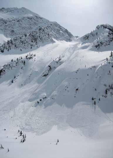
3 Glacier East Slide Paths

4 Tupper - Connaught Slide Path Tupper Rogers Swiss Hermit Swiss Glacier

5 Tupper - Connaught Slide Path
6 Hermit

7 Hermit Tupper Sifton Rogers Fleming Grant Swiss Truda Hermit Meadows Hermit Slide Path

8 Hermit Grizzly Little Sifton Sifton Swiss Rogers Peaks Hermit Tupper Hermit Meadows Grizzly Slide Path Lone Pine Slide Path

9 Hermit Hermit Tupper Hermit Slide Path

10 Hermit Rogers Swiss Peaks Truda Hermit Swiss Glacier

11 Hermit Little Sifton Little Sifton- Sifton Col Grizzly Shoulder Hermit Meadows

12 Hermit - Tupper Traverse from Hermit Tupper Tupper Glacier
13 Macdonald and Avalanche

14 Macdonald - Crossover Slide Path Crossover slide path Macdonald West Shoulder WPA

15 Macdonald - Crossover Slide Path
16 Macdonald and Avalanche Macdonald Avalanche Macdonald West Shoulder WPA Avalanche WRA Macdonald WRA

17 Macdonald West Shoulder Avalanche Peak #1 #2 #3 #4 Shoulder Valley Vent Shaft Ridge Macdonald West Shoulder WPA NRC NRC Gully
18 Macdonald West Shoulder NRC Gully Avalanche Avalanche Crest Shoulder Valley Vent Shaft Ridge Macdonald West Shoulder WPA NRC NRC Gully

19 Avalanche Crest Sir Donald Avalanche Eagle Uto Vent Shaft Ridge Kors- Thomas Bowl Avalanche Crest The Overlook

20 Avalanche Crest Bowl Avalanche Eagle Avalanche Crest Avalanche Moraines

21 Avalanche Crest Bowl Eagle Avalanche Moraines

22 Avalanche Crest Bowl Eagle Avalanche Moraines

23 Avalanche - Avalanche Crest Bowl Eagle Avalanche Avalanche Crest
 Avalanche Avalanche")
24 Avalanche (from Macdonald West Shoulder) Avalanche Avalanche Glacier

25 Connaught Creek Drainage
26 Connaught - The Hourglass

27 Grizzly Mountain Connaught - Grizzly Bowl Frequent Flyer Grizzly Couloir Little Sifton Sifton Rogers Teddy Bear Ridge Grizzly Shoulder
28 Connaught Ursus Minor Grizzly Grizzly Couloir Grizzly Knob Little Sifton Teddy Bear Trees Grizzly Shoulder Rogers Run Grizzly West/ Puff Daddy

29 Connaught - Grizzly Shoulder Grizzly Grizzly Knob Sifton Hermit Grizzly Shoulder Rogers Run Grizzly West/ Puff Daddy

30 Connaught - Grizzly Shoulder Grizzly Knob Hermit Bowl Grizzly Shoulder

31 Connaught - Grizzly Shoulder Sifton Rogers Swiss Peaks Truda Hermit Grizzly Shoulder Grizzly Bowl

32 Connaught - Little Sifton Sifton Little Sifton Grizzly Shoulder Grizzly Slide Path Hermit Meadows

33 Connaught - Little Sifton Little Sifton Grizzly Shoulder

34 Connaught - Grizzly Peak Grizzly


35 Connaught - Teddy Bear Trees Grizzly Ursus Minor Frequent Flyer Teddy Bear Trees Frequent Flyer Teddy Bear Trees

36 Connaught - Teddy Bear Trees Frequent Flyer Teddy Bear Ridge Teddy Bear Trees

37 Connaught 8812 Cheops Balu Pass Christmas Trees Ursus Trees Teddy Bear Trees Grizzly Trees

38 Ursus Major /Balu Bruins Pass Video Peak Ursus Minor Balu Ridge 8812 Bowl Bruins Ridge Ursus Minor Bowl Balu Pass
39 Connaught - Video Peak Video Peak 8812

40 Connaught - East of Balu Pass Ursus Minor Balu Pass 8812 Bowl 8812 Bruins Pass Video Peak Ursus Basin/ Hospital Bowl Ursus Trees Dispatcher s Bowl Hospital Knob Hospital Gully Christmas Trees

41 Connaught - Ursus and Dispatcher s Bowls Grizzly Ursus Minor Bruins Video Dispatcher s Bowl Ursus Basin/ Hospital Bowl Ursus Trees Christmas Trees

42 Connaught - Dispatcher s Bowl Ursus Minor Grizzly Bearpole Col Dispatcher s Bowl Waterfall

43 Balu (from Cougar Valley) Ursus Major 8812 Video Ursus Minor Grizzly Cougar Valley 8812 Bowl Ursus Basin Dispatcher s Bowl Cheops Balu Pass

44 Connaught (from Balu Pass) Macdonald Cheops 8812 Bowl Balu Pass

45 Balu Pass West Aspect Cheops West Face Balu Pass

46 Connaught - Cheops North Cheops Balu Pass Cheops North Bowl Cheops North 1

47 Connaught - Cheops North Cheops Cheops North 4 Niccy s Notch Balu Pass Cheops North Bowl Cheops North 5

48 Connaught - Cheops North Cheops North 4 Cheops North 5 Cheops North 5

49 Cheops (from Ursus Major) Youngs Peak Cheops Illecillewaet Glacier Glacier Crest Cheops West Face Niccy s Notch Balu Pass

50 Ursus Creek Drainage
51 Ursus Creek Peak and Ursus Major 8812 Peak Ursus Major Bruins Pass Bruins Glacier

52 Ursus Creek - Ursus Major Ursus Major Bruins Glacier

53 Ursus Major Ursus Creek - Ursus Major Ursus Major Col Bruins Glacier

54 Ursus Creek - Bruins Glacier (from below) 8812 Peak Ursus Major Bruins Pass Bruins Glacier

55 Ursus Creek - Ursus Minor West Face Ursus Minor

56 Ursus Minor Ursus Creek - Video Peak North Video Peak

57 Cougar Valley
58 Cougar Valley McGill Bagheera Catamount Catamount Pass Ursus Major 8812 Cougar Cheops Winter Prohibited Area Cougar Valley

59 Cougar Valley Ursus Major Cougar Cougar Pass McGill Bagheera Catamount Catamount Pass Cougar Valley Balu Pass

60 Cougar Valley Cheops Balu Pass Cougar Pass

61 Cougar Valley (from Cheops) Bagheera Catamount Cougar Pass Catamount Pass Ursus Major 8812 Balu Pass

62 Cougar - Ursus Major Ursus Major
63 Cheops Mountain
64 Cheops East Aspect Cheops Balu Pass Napoleon Spur Hourglass Cheops 1 Cheops 2

65 Cheops - South Aspect Cheops Napoleon Spur

66 Cheops (from Loop Brook) Cheops Cheops West Face Hermit Tupper Junction West Napoleon Spur Junction East

67 Cheops Napoleon Spur Cheops

68 Cheops - Napoleon Spur South Aspect
69 Illecillewaet
70 Illecillewaet Drainage Panorama Sir Donald Uto North Terminal The Overlook Vaux Moraine Perley Rock Lookout Col Lookout Glacier Crest Practice Slopes

71 North Terminal Illecillewaet Glacier Toe Perley Rock Lookout Col Lookout Glacier Crest Practice Slopes

72 Illecillewaet (July 2011) Sir Donald South Terminal Perley Rock Illecillewaet Glacier Lookout Col

73 Illecillewaet Uto Eagle Avalanche The Overlook Practice Slopes

74 Illecillewaet - Practice Slopes Eagle Uto Uto-Sir Donald Col The Overlook Practice Slopes

75 Illecillewaet The Overlook Uto Northwest Ridge

76 Illecillewaet - Lookout Col Sir Donald Uto North Terminal South Terminal Illecillewaet Glacier Perley Rock Lookout Col Lookout Couloirs Glacier Crest The Ravens
 Lookout Couloirs Asulkan")
77 Illecillewaet - Lookout Couloirs (from Lookout Col) Lookout Couloirs Asulkan Pass

78 Illecillewaet - Lookout Col Glacier Crest Lookout Col

79 Illecillewaet- Terminal from Youngs Sir Donald South Terminal Terminal-Terminal Col North Terminal Illecillewaet Glacier

80 Illecillewaet - Terminal Terminal Terminal Col
81 Asulkan

82 Asulkan - Abbott Rampart Abbott Dome Afton Abbott Ridge Bonney Abbott Hut Abbott WPA Observatory Observatory Minor

83 Asulkan - Abbott Abbott Ridge Abbott Hut Abbott WPA Observatory
84 Afton Abbott Asulkan Abbott Ridge Abbott WPA Mushroom People

85 Rampart Afton Asulkan Cleaver Abbott Abbott Ridge Dome Glacier Triangle Moraine Mushroom People The Mousetrap


86 Asulkan - Abbott and Mushroom People Abbott Afton Abbott Abbott Ridge Mushroom People Mushroom People

87 Asulkan Asulkan Pass Leda Jupiter Pollux Castor Asulkan Glacier Sapphire Col Cleaver Dome Mushroom People

88 Asulkan - Dome Glacier Dome Dome Col Sapphire Col Cleaver Dome Glacier

89 Asulkan - Cleaver Dome Asulkan Glacier Cleaver Dome Glacier

90 Asulkan - Jupiter Leda Pollux Castor Asulkan Pass Sapphire Col Asulkan Glacier

91 Asulkan (July 2011) Leda Pollux Castor Sapphire Col Asulkan Glacier Triangle Moraine

92 Asulkan - Sapphire Col Sapphire Col Dome Bonney The Rampart Asulkan Glacier Cleaver Dome Glacier Triangle Moraine

93 Asulkan (July 2011) Asulkan Glacier Cleaver Dome Glacier

94 Asulkan (July 2011) Sapphire Col Asulkan Glacier Cleaver

95 Asulkan Dawson Group (from Sapphire Col) Michel Donkin Pass Donkin Purity Incomappleux River Valley

96 Asulkan (view south of Asulkan Pass) Fox Topham Selwyn Hasler Feuz Michel

97 Asulkan - Dawson Group (from Youngs Peak) Fox Hasler Comstock Couloir Feuz Michel Purity Donkin Donkin Pass

98 Asulkan Fox Selwyn Hasler Youngs Peak Asulkan Pass
99 Asulkan - Lookout Notch Sir Donald Uto North Terminal South Terminal Illecillewaet Glacier Perley Rock Glacier Crest Lookout Col Lookout Couloirs The Ravens

100 Asulkan to Illecillewaet Sir Donald Avalanche Eagle Uto South Terminal Perley Rock Illecillewaet Glacier Glacier Crest Lookout Col The Ravens The Mousetrap

101 Asulkan - The Ravens Lookout Lookout Col The Ravens
102 Asulkan - Sapphire Col (from west side) Avalanche Eagle Uto Sir Donald Castor Sapphire Col Hut Lily Col

103 Asulkan / Illecillewaet - Youngs Peak Traverse Youngs Peak Forever Young

104 Asulkan Hut area Forever Young Youngs Asulkan Glacier Pterodactyl Asulkan Hut Asulkan Pass Tree Triangle Mousetrap

105 Asulkan - The Mouse Trap Tree Triangle
 7 Steps of")
106 Asulkan - Youngs Peak (from Asulkan Hut) 7 Steps of Paradise

107 Asulkan - Youngs Peak Youngs Peak Asulkan Pass 7 Steps of Paradise

108 Asulkan - Asulkan Hut and Youngs Peak Sir Donald Youngs South Terminal Lookout Asulkan Pass Asulkan Hut Asulkan Glacier

109 Asulkan (July 2011) Youngs Asulkan Glacier Asulkan Hut

110 Asulkan Youngs Asulkan Pass Asulkan Hut

111 Asulkan - Youngs Peak Youngs

112 Asulkan - Forever Young

113 Asulkan Youngs Peak 7 Steps of Paradise Pterodactyl

114 Loop Brook
115 Loop Brook Dome Col Dome Swanzy Tuzo Couloir Clark Bonney Lily Col Lily Glacier Bonney Glacier Bonney Moraines Bonney Trees

116 Loop Brook (July 2011) Dome Swanzy Lily Col Lily Glacier Bonney Glacier

117 Loop Brook Bonney-Green Col Green Ross Bonney Moraines East Bonney Trees

118 Loop Brook (July 2011 from Abbott) Bonney Bonney Glacier Bonney Moraines West Bonney Trees

119 Loop Brook (July 2011) Bonney Green Bonney Glacier
 Swanzy Bonney")
120 Loop Brook - Bonney Glacier (February 2014) Swanzy Bonney Bonney Glacier

121 Loop Brook - Bonney Trees Bonney Moraines West Bonney Trees

122 Loop Brook - Approach to Mt Green Bonney-Green Col

123 Loop Brook - Lilly Dome Col Swanzy Dome Lily Glacier Lily Col
124 Loop Brook - Sapphire Col (from west side) Sir Donald Castor Avalanche Eagle Uto Sapphire Col Hut Lily Col

125 Loop Brook - Swanzy Eastern Aspect Swanzy Swanzy Glacier Lily Col

126 Loop Brook - Swanzy Eastern Aspect Swanzy Swanzy Glacier Lily Col
 Bonney")
127 Loop Brook - Bonney West Face (from Patience) Bonney Smart


128 Loop Brook Ross Green Green Bonney Glacier Ross Peak Slide Path

129 Loop Brook - Abbott and Afton (from west) Afton Uto Sir Donald Abbott Ridge Abbott Abbott WPA

130 Loop Brook - Abbott Abbott WPA
131 Glacier Circle

132 Fox Glacier Circle Witches Tower Youngs Hut

133 Glacier Circle - Macoun Route Selwyn Topham Deville Fox Macoun Witches Tower

134 Glacier Circle - Macoun Route

135 Glacier Circle - Macoun Route

136 Glacier Circle - Witches Tower Route Witches Tower Youngs Peak

137 Glacier Circle Macoun Topham Geikie Glacier

138 Glacier Circle Macoun Geikie Glacier

139 Glacier Circle Fox descent Illecillewaet Neve
140 Deville

141 Deville Neve Deville Headwall Selwyn Ledges

142 Deville Rappels Original Route: 4 x 50m bolted rappels New route: 3 x 30m bolted rappels

143 April New Route For detailed information contact Glacier Visitor Safety Specialists at Deville Rappels Stn 1 25 m Stn 2 30m Stn 3 30 m T-Slot or steep ski


144 Deville Rappels Cairn Station 1 Station 2


145 Deville Rappels Stn #1 UTM at first station is: 11U / Top of Rappels Bottom of rappels Stn #2: Stn #3: Stn #2:

146 Deville - Beaver Overlook

147 Deville - Grand Grand High Col

148 Deville - Mount Kilpatrick

149 Deville - Mount Wheeler Deville Neve

150 Deville - Mount Wheeler Deville Neve

151 Deville - Sugarloaf
152 Bostock and McGill

153 Bostock - McGill McGill McGill Paths Gun Barrels Camp West McGill Trees McGill Shoulder

154 Bostock- McGill McGill McGill Paths McGill Trees Bostock Summer Trail

155 Bostock - McGill McGill McGill Pass McGill Paths

156 McGill Paths McGill

157 McGill and Camp West McGill Copper McGill Pass Camp West McGill Shoulder

158 McGill and Camp West McGill Copper Camp West McGill Shoulder

159 McGill and Camp West McGill Camp West McGill Shoulder Moccasin Flats
160 Fidelity and Christiana Fidelity Fidelity Prohibited Area North Cirque Dafoe s Wiggle
161 Fidelity Fidelity Fidelity Prohibited Area Christiana Trees
162 Fidelity - Christiana Trees Fidelity Prohibited Area Christiana Trees
163 Fidelity - Christiana Trees Fidelity Prohibited Area Christiana Trees
164 Flat Creek
165 Flat Creek - Fortitude Fortitude sub-summit Flat Creek Pass Fortitude Slide Path Fortitude Ridge Flat Creek Highway

166 Flat Creek Slick Flat Creek Pass Smart Flat Creek Highway

167 Flat Creek - Fortitude

168 Flat Creek Fortitude Fortitude sub-summit

169 Flat Creek Patience Fortitude

170 Flat Creek - Fortitude Fortitude sub-summit Fortitude Slide Path Cats Claws
171 Flat Flat Creek- - Smart Smart Stegosaur Ridge Slick Tomatin Findhorn Flat Creek TCH

172 Flat Creek - Smart Smart Smart Paths Flat Creek TCH

173 Flat Creek- Smart Bonney Smart Stegosaur Ridge Smart Paths

174 Flat Creek - Mount Slick Northeast Aspect Slick Flat Creek

175 Flat Creek - Smart East Aspect Smart Flat Creek Highway

176 Flat Creek Hope Charity
177 Mount Revelstoke

178 Mount Revelstoke - Clachnacudainn Icefield Coursier Woolsey Glacier Woolsey Shelter

179 Mount Revelstoke - Clachnacudainn Icefield Inverness Inverness Glacier
180 Select Winter Permit System Boundaries NOTE: Not all Permit Areas are included in this document WRA - Winter Restricted Area A valid Winter Permit is required to park a vehicle or ski in these areas. Permit holders can only ski here on days when the area is posted as open, when there is no chance of artillery fire happening in the area. WPA - Winter Prohibited Area These areas are closed to visitors all winter. The areas are used for snow study, explosive testing or are at risk of triggering avalanches directly onto the highway

181 Macdonald WRA, Macdonald West Shoulder WPA and Avalanche WRA Macdonald Avalanche Avalanche WRA Macdonald West Shoulder WPA Macdonald WRA

182 Macdonald West Shoulder WPA and Avalanche WRA Avalanche Avalanche Crest Macdonald West Shoulder WPA Avalanche WRA
183 Grizzly Peak Hermit and Grizzly Shoulder WRA Little Sifton Hermit WRA Grizzly Shoulder WRA

184 Grizzly Peak Hermit and Grizzly Shoulder WRA Little Sifton Hermit WRA Grizzly Shoulder WRA
185 Cheops North WRA Cheops Balu Pass Cheops North WRA

186 Loop Brook WRA and Abbott WPA Loop Brook WRA Abbott WPA

187 Loop Brook WRA and Abbott WPA Loop Brook WRA Abbott WPA Asulkan Parking

188 Fidelity Prohibited Area Fidelity Fidelity Prohibited Area Christiana Trees

189 Fidelity Prohibited Area Fidelity Fidelity Prohibited Area Christiana Trees

190 Fidelity Prohibited Area Fidelity Prohibited Area Christiana Trees
TUPPER DESIGNATED ACCESS ROUTE
 TUPPER DESIGNATED ACCESS ROUTE 1 FOR ACCESS/EGRESS TO CONNAUGHT, LOOKOUT, STONE ARCH, PORTAL PATHS AND TUPPER TRAVERSE EGRESS Length: 2.6km Vertical Gain: +162m / -83m (Values are for access. For egress,
Route #1) Mt. of the Holy Cross - North Ridge
 Mt. of the Holy Cross - North Ridge") Climbing 14ers can be very dangerous, please read the Mountaineering Safety Page and make sure you have a map+compass and can use them effectively, without the help of electronic devices. Route #1) Mt.
Climbing 14ers can be very dangerous, please read the Mountaineering Safety Page and make sure you have a map+compass and can use them effectively, without the help of electronic devices. Route #1) Mt.
Example of the layout of a Fieldwork Atlas
 Example of the layout of a Fieldwork Atlas Example of a Worksite with multiple facilities and work goals in one area: Map Center 49 3 46 N 117 3 11 W Noname Area with typical travel route marked. Avalanche
ENVIRONMENTAL HAZARDS OF AVALANCHES: PRELIMINARY RESEARCH IN GLACIER NATIONAL PARK
 ENVIRONMENTAL HAZARDS OF AVALANCHES: PRELIMINARY RESEARCH IN GLACIER NATIONAL PARK Site Focus: Balu Pass, Glacier National Park, B.C. Avalanche path near Balu Pass. (Photo Courtesy of: www.leelau.net/2007/rogerspass/day1/1)
C E N T R A L C A T S K I L L S
 120 C E N T R A L C A T S K I L L S Central Catskills Once out of the southern parts of the Catskills, the Long Path enters the more well traveled and civilized regions. The trail joins the Devil s Path,
Dnigi Hut. Dnigi is Dnaina for Moose. Location:
 Dnigi Hut in places. Stay on the main thoroughfare. Continue along the ridge top, going east to a pass above Knob Creek. Just beyond here look for a left turn which descends north-northwest (61,45.578,-148,52.414,2081
Route #2) Mt. Massive - Southwest Slopes
 Mt. Massive - Southwest Slopes") Route #2) Mt. Massive - Southwest Slopes Difficulty: Class 2 Ski: Advanced, D6 / R2 / III Exposure: Summit Elevation: Trailhead Elevation: Elevation Gain: Round-trip Length: Trailhead: County Sheriff:
Route #2) Mt. Massive - Southwest Slopes Difficulty: Class 2 Ski: Advanced, D6 / R2 / III Exposure: Summit Elevation: Trailhead Elevation: Elevation Gain: Round-trip Length: Trailhead: County Sheriff:
ABSTRACT. Copyright Environment Canada, Canadian Parks Service, 1989
 KEL^LZ3 ABSTRACT The Rogers Pass avalanche defence operation protects a 40 km segment of highway and railway corridor centered on Rogers Pass. Glacier National Park, British Columbia. Canada. One hundred
Route Combo) Mt. Bierstadt - Bierstadt, Sawtooth, Evans
 Mt. Bierstadt - Bierstadt, Sawtooth, Evans") Climbing 14ers can be very dangerous, please read the Mountaineering Safety Page and make sure you have a map+compass and can use them effectively, without the help of electronic devices. Route Combo)
Climbing 14ers can be very dangerous, please read the Mountaineering Safety Page and make sure you have a map+compass and can use them effectively, without the help of electronic devices. Route Combo)
parkscanada.gc.ca Contributors
 ZUZANA DRIEDIGER Contributors Designer Kathryn Whiteside Print and Interactive Design parkscanada.gc.ca Call our toll-free information line 1-888-773-8888 Mount Revelstoke and Glacier National Parks reception
playwinterpark.com Off The Beaten Path Hikes Hiking Recommendations for the Adventurous Hiker
 playwinterpark.com Off The Beaten Path Hikes Hiking Recommendations for the Adventurous Hiker Hike: Devil s Thumb (difficult) Length: 3.93 miles one-way Elevation: Trailhead 9609 Destination 12,236 Trailhead
beach. Make the ford and follow the trail out to the junction with Red Creek Tr in an open grassy area.
 Description: This is a moderate to slightly strenuous 22.8 mile backpack (add 2.6 miles if you do the packless out and back to the Lion s Head) that will have you exploring nearly every thing that is The
Asulkan Valley Avalanche track. Geography 477 Fall 2007 Penny Simpson, Jessica Paramio, Maciej Stetkiewicz, Ashley Dittmer
 Asulkan Valley Avalanche track Geography 477 Fall 2007 Penny Simpson, Jessica Paramio, Maciej Stetkiewicz, Ashley Dittmer RationaleRationale Objectives Background Methodology ResultsResults Discussion
Pocahontas Area Map Jasper INFORMATION CENTRES Lake Louise Field Golden Banff
 Pocahontas Miette Hot Springs Area Map Jasper Maligne JASPER Columbia Icefield Saskatchewan River Crossing INFORMATION CENTRES Banff National Park Louise Kootenay Park Lodge Yoho National Park Columbia
Date Name Trail Segment Conditions, Hazards and General Notes on Trails
 Trail Reports for Sawtooth NRA ***Unless otherwise reported-expect high creeks, snow levels at 7500 ft. and trees on trails. Due to high winds in the area, if trees were previously reported removed there
The Trails. Hwy. 40 Kananaskis Valley. Hwy. 1 Canmore, Bow Valley. Hwy. 40 Peter Lougheed Prov. Park. Hwy. 742 The Smith-Dorrien. Hwy.
 The Trails Hwy. 1 Canmore, Bow Valley 1 Grassi 8 2 Ha Ling Peak 13 3 Teahouse Ridge 17 4 Grotto Canyon 21 5 Raven s End 24 6 Bow Valley Provincial Park Loop 28 7 Heart Mountain Circuit 32 8 Wind Ridge
Slot Couloir Accident, Snoqualmie Mt
 Body Page 1 Slot Couloir Accident, Snoqualmie Mt 4-27-14 Date and Time: estimated 12 pm, Sunday 4/27/14 Location: Slot Couloir, Snoqualmie Mt Number in Party: 2 backcountry skiers Number hurt: 1 backcountry
Date Name Trail Segment Conditions, Hazards and General Notes on Trails
 Trail Reports for Sawtooth NRA ***Unless otherwise reported-expect high creeks, snow levels at 7900 ft. and trees on trails. Due to high winds in the area, if trees were previously reported removed there
HIKING IN THE CANADIAN ROCKIES
 HIKING IN THE CANADIAN ROCKIES Distance Time Elevation y MORAINE LAKE TRAILS THE ROCKPILE 0.8 km (0.5 mi) 20 min 30 m (98 ft) Located adjacent to the Lodge, the short interpretive trail up the Rock Pile
SYNOPSIS WEATHER AND SNOWPACK
 Peak 6996 Avalanche Fatality Incident Report Glacier National Park, MT Date of Avalanche: 31 March 2010 Date of Investigation: 2 April 2010 Investigation Team: Erich Peitzsch (USGS), Ted Steiner (Chugach
GOLDEN EARS PROVINCIAL PARK
 GOLDEN EARS PROVINCIAL PARK Trail Information as of October 10 th 2015 Do not underestimate the mountainous wilderness of Golden Ears Provincial Park. The combination of rugged terrain and rapidly changing
Going-to-the-Sun Road, Glacier National Park, MT, USA Avalanche Path Atlas
 Going-to-the-Sun Road, Glacier National Park, MT, USA Avalanche Path Atlas Erich H. Peitzsch Daniel B. Fagre USGS Northern Rocky Mountain Science Center West Glacier, MT, USA Introduction... 2 Overview
Trail Phasing Plan. Note: Trails in the Clear Creek Canyon area (Segments will be finalized in the future to minimize wildlife impacts
 Note: Trails in the Clear Creek Canyon area (Segments 2 5 and a future JCOS connection) will be finalized in the future to minimize wildlife impacts Trail Phasing Plan P Parking 3 Easy Trail Intermediate
BRR Leg 13 (9.3 miles, Very Hard)
") BRR Leg 13 (9.3 miles, Very Hard) Min 3205 Max 3840 Ascent +978 Descent -719 Leg Notes: Support vehicles are not permitted on the Blue Ridge Parkway. Runners must wear a reflective vest while running on
BRR Leg 13 (9.3 miles, Very Hard) Min 3205 Max 3840 Ascent +978 Descent -719 Leg Notes: Support vehicles are not permitted on the Blue Ridge Parkway. Runners must wear a reflective vest while running on
GIFFORD PINCHOT NATIONAL FOREST
 GIFFORD PINCHOT NATIONAL FOREST 9341 Wright Meadow 93 Spencer Meadow Spencer Butte 4247' 30 30A 19 24 80 31C Lewis River Lower Falls 5 Quartz Creek 90 Taidnapam Falls Upper Falls 31 Spencer Peak 3861'
Crystal Lake Area Trails
 Lake Area Trails Welcome to the Lake area of the Big Snowy Mountains! This island mountain range in central Montana features peaks reaching to 8,600 feet and long, high ridges from which vistas of the
Alaska Mountaineering Mt. Drum Expedition
 St. Elias Alpine Guides, LLC Wrangell-St. Elias National Park, Alaska (888) 933-5427 (907) 345-9048 www.steliasguides.com Alaska Mountaineering Mt. Drum Expedition Mt. Drum, an extinct volcano, rises 12,010
9 December 2016 Maxwell Wolckenhauer NYS DEC State Highway 10, Suite 1 Stamford, NY Conservation.
 Conservation Education Recreation Since 1922 9 December 2016 Maxwell Wolckenhauer NYS DEC 65561 State Highway 10, Suite 1 Stamford, NY 12167 r4.ump@dec.ny.gov RE: Windham-Blackhead Range Wilderness UMP
Jumbo Glacier Resort Master Plan Appendix 2-A
 Jumbo Glacier Resort Master Plan Appendix 2-A Avalanche Studies and Reports prepared by P. Schaerer of Stetham & Associates Pheidias Project Management Corp. Copyright June, 2005 JUMBO
Tsar/Somervell - Shackleton Group
 Tsar/Somervell - Shackleton Group The peaks of the Tsar/Somervell and Shackleton group are part of the larger Clemenceau Icefield set which are located between the Alberta-British Columbia divide on the
Garibaldi Provincial Park Trail Conditions
 Garibaldi Provincial Park s August 2, 2018 Garibaldi Park is located in the coast mountain wilderness and the weather can be severe and unforgiving. Be well prepared, properly equipped and informed before
Date Name Trail Segment Conditions, Hazards and General Notes on Trails
 Trail Reports for Sawtooth NRA ***Unless otherwise reported-expect high creeks, snow levels at 7900 ft. and trees on trails. Due to high winds in the area, if trees were previously reported removed there
c. 1 inch = 0.6 miles e. 1:100,000 f. 1:250,000 f. 1 inch = 4.0 miles
 High School Advance Geology Map Test 2014 Name Use the information on each map to provide the best answer to the questions. Fill in the bubble of the best answer on your answer sheet. Answer questions
Anderson Mt. Proposed Wilderness Additions to the Rogue-Umpqua Divide Wilderness-- T30S R3E (mostly) Sections 4 & 9, and T29S R3E Section 33
 Sections 4 & 9, and T29S R3E Section 33") Anderson Mt. Proposed Wilderness Additions to the Rogue-Umpqua Divide Wilderness-- T30S R3E (mostly) Sections 4 & 9, and T29S R3E Section 33 When the 35,701 acre Rogue-Umpqua Divide Wilderness was designated
Anderson Mt. Proposed Wilderness Additions to the Rogue-Umpqua Divide Wilderness-- T30S R3E (mostly) Sections 4 & 9, and T29S R3E Section 33 When the 35,701 acre Rogue-Umpqua Divide Wilderness was designated
NWAC Blog. Cornices - don't walk the line! Written by Robert Hahn on March 14, Last update on May 15, 2017.
 NWAC Blog Cornices - don't walk the line! Written by Robert Hahn on March 14, 2017. Last update on May 15, 2017. Human-triggered cornice fall avalanche from March 10th, 2017. The crown release exposed
Three Sisters Wilderness Oct. 2009
 Three Sisters Wilderness Oct. 2009 I was in Bend, OR and had the whole day to travel back to Boise so I decided to take a hike to the popular Green Lakes and summit the South Sister in Three Sisters Wilderness.
Date Name Trail Segment Conditions, Hazards and General Notes on Trails
 Trail Reports for Sawtooth NRA ***Unless otherwise reported-expect high creeks, snow levels at 7900 ft. and trees on trails. Due to high winds in the area, if trees were previously reported removed there
CATSKILL 3500 CLUB HIKE SCHEDULE SPRING 2019
 CATSKILL 3500 CLUB HIKE SCHEDULE SPRING 2019 Sat. Apr. 6 - NORTH DOME & SHERRILL Distance: 6.5 mi. Ascent: 2700' Elevs: 3610', 3540' Strenuous bushwhack to two remote peaks. Well behaved dogs are welcome.
Mt. Hood [Map Pack Bundle] (National Geographic Trails Illustrated Map) By National Geographic Maps - Trails Illustrated READ ONLINE
![Mt. Hood [Map Pack Bundle] (National Geographic Trails Illustrated Map) By National Geographic Maps - Trails Illustrated READ ONLINE](/thumbs/85/92056945.jpg "Mt. Hood [Map Pack Bundle] (National Geographic Trails Illustrated Map) By National Geographic Maps - Trails Illustrated READ ONLINE") Mt. Hood [Map Pack Bundle] (National Geographic Trails Illustrated Map) By National Geographic Maps - Trails Illustrated READ ONLINE If you are looking for a book by National Geographic Maps - Trails Illustrated
Mt. Hood [Map Pack Bundle] (National Geographic Trails Illustrated Map) By National Geographic Maps - Trails Illustrated READ ONLINE If you are looking for a book by National Geographic Maps - Trails Illustrated
Sunday / Monday - Osceolas
 AMC August 3, 2015 Sunday / Monday - Osceolas 0 1737 ft 2007, Appalachian Mountain Club. All rights reserved. Notes Created by AMC White Mountain Guide Online wmgonline.org 1 Distance Time Elev Change
Hiking Trail Descriptions
 Hiking Trail Descriptions For ye shall go out with joy. And be led forth with peace. The mountains and the hills shall break forth before you in singing. And all the trees of the fields shall clap their
Bradshaw Trails Series
 Bradshaw Trails Series Curtis James Troop 7014 Curtis.James@erau.edu My Motto: Never get lost! Hiking Rules Bradshaw Hiking Patch Series Hiking Tools Hiking Rules Hiking Merit Badge* Take five 10-mile
Hiking Las Vegas.com
 Hike: Mt. Wilson via First Creek Canyon route Trailhead: First Creek marked Distance: 10 miles up and back Elevation gain: 3,400 feet Elevation of Peak: 7,070 feet Time: 7 to 9 hours (up and back) Difficulty:
Rogue Gorge (Mt. Stella) Roadless Area-- T30S R3E (primarily in portions of Sections 23, 26, 33, 34 & 35)
 Roadless Area-- T30S R3E (primarily in portions of Sections 23, 26, 33, 34 & 35)") Rogue Gorge (Mt. Stella) Roadless Area-- T30S R3E (primarily in portions of Sections 23, 26, 33, 34 & 35) Rogue River-Siskiyou National Forest--High Cascades Ranger District Upper, higher elevation trail
Rogue Gorge (Mt. Stella) Roadless Area-- T30S R3E (primarily in portions of Sections 23, 26, 33, 34 & 35) Rogue River-Siskiyou National Forest--High Cascades Ranger District Upper, higher elevation trail
PREPARE TO STOP DIP ROUGH ROAD SPEED ZONE AHEAD DANGER STOP AT PULLOFF ONLY 30 MUXIMUM SLOW TRAFFIC KEEP RIGHT. FOrm SINGLE LINE.
 SPEED ZONE AHEAD PREPARE TO STOP DANGER STOP AT PULLOFF ONLY 30 SLOW TRAFFIC KEEP RIGHT Maple Leaf FOrm SINGLE LINE DIP ROUGH ROAD MUXIMUM 30 (1101) éé 7/1 7/2 7/3 7/4 7/5 7/6 7/7~8 7/9 7/10 Monashe Mountain
Guide Book Excerpts From Colorado Hut to Hut, Volume 1 Northern & Central Regions, by Brian Litz
 Guide Book Excerpts From Colorado Hut to Hut, Volume 1 Northern & Central Regions, by Brian Litz Sangree M. Froelicher Hut HUT 11,630 ELEVATION DATE BUILT 1998 SEASONS Thanksgiving through April 30 (winter);
LAB P - GLACIAL PROCESSES AND LANDSCAPES
 Introduction LAB P - GLACIAL PROCESSES AND LANDSCAPES Ice has been a significant force in modifying the surface of the earth at numerous times throughout Earth s history. Though more important during the
Seven mountain peaks you must admire in Washington state
 Seven mountain peaks you must admire in Washington state heraldnet.com /life/seven-mountain-peaks-you-must-admire-in-washington-state/ From a distance, the mountains of the Cascade and the Olympic ranges
U.S.D.A. FOREST SERVICE KETCHUM RANGER DISTRICT 206 SUN VALLEY ROAD P.O. BOX 2356 KETCHUM, ID (208)
") U.S.D.A. FOREST SERVICE KETCHUM RANGER DISTRICT 206 SUN VALLEY ROAD P.O. BOX 2356 KETCHUM, ID 83340 (208) 622-5371 Road and Trail Report 05/8/2015 More trails opened in Greenhorn this week. Only high elevation
U.S.D.A. FOREST SERVICE KETCHUM RANGER DISTRICT 206 SUN VALLEY ROAD P.O. BOX 2356 KETCHUM, ID 83340 (208) 622-5371 Road and Trail Report 05/8/2015 More trails opened in Greenhorn this week. Only high elevation
Road and Trail Report 04/02/2015
 U.S.D.A. FOREST SERVICE KETCHUM RANGER DISTRICT 206 SUN VALLEY ROAD P.O. BOX 2356 KETCHUM, ID 83340 (208) 622-5371 Road and Trail Report 04/02/2015 o Dry weather and a dwindling snowpack continue to bring
21 Aug. 2004, 9:45am, at the Paradise trailhead. The day before the climb, we all took part in a one-day climbing school to refresh our skills in
 21 Aug. 2004, 9:45am, at the Paradise trailhead. The day before the climb, we all took part in a one-day climbing school to refresh our skills in walking with crampons on snow and ice, and in arresting
WARNING Due to Extensive Beetle Kill Trees, Trails are Subject to Closure or Rerouting. Please be Advised and Pay attention to On Ground Signage.
 WARNING Due to Extensive Beetle Kill Trees, Trails are Subject to Closure or Rerouting. Please be Advised and Pay attention to On Ground Signage. WYOMING RANGE WESTERN WYOMING The Wyoming Range trail system
Trail Report for KOKANEE GLACIER PROVINCIAL PARK and other Kootenay Lake Area parks (including west side of Purcell Wilderness Conservancy)
") Updated: October 23, 2017 Please call 250-354-6333 if you have new trail conditions to report. PARK AREA ROADS TRAILS ADDITIONAL INFORMATION Kokanee Creek SPECIAL NOTICE: Trail from Gibson Lake to drainage
Updated: October 23, 2017 Please call 250-354-6333 if you have new trail conditions to report. PARK AREA ROADS TRAILS ADDITIONAL INFORMATION Kokanee Creek SPECIAL NOTICE: Trail from Gibson Lake to drainage
HUNTING PROPERTIES Bearpaw Trail Hand constructed with reclaimed timbers from a historic Stagestop.
 $4,500,000 #139289 428.0 AC $2,500,000 #138964 113.5 AC $24,9500,000 #137591 9,000.0 AC 8855 Bearpaw Trail Includes a 3 acre lake and borders Routt National Forest. 8925 Bearpaw Trail Hand constructed
Proceedings, International Snow Science Workshop, Breckenridge, Colorado, 2016
 THE WHITE PASS AND YUKON ROUTE AVALANCHE PROGRAM, FORECASTING AND RISK MAN- AGEMENT FOR A HISTORICAL RAILROAD Bill Glude Alaska Avalanche Specialists, Juneau, AK The White Pass and Yukon Route (WPYR) is
CIEC 9 PEAKS AWARD SUPPLEMENT POSSIBLE ROUTES FOR THE 9 PEAKS AWARD TRIP
 CIEC 9 PEAKS AWARD SUPPLEMENT POSSIBLE ROUTES FOR THE 9 PEAKS AWARD TRIP As you plan your trip, be aware of 3 regulations in this wilderness: 1. Camp only in designated campsites. 2. No campfires allowed.
Geologic Trips, Sierra Nevada
 ISBN 0-9661316-5-7 GeoPress Excerpt from Geologic Trips, Sierra Nevada by Ted Konigsmark All rights reserved. No part of this book may be reproduced without written permission, except for critical articles
ANUMC Ski Mountaineering Expedition. Classic Haute Route ANUMC Expedition Fund Application By Andrew Gough
 ANUMC Ski Mountaineering Expedition Classic Haute Route 2010 ANUMC Expedition Fund Application By Andrew Gough Introduction: The Haute route (or High Mountaineers Route ) is one of the worlds most famous
Avalanche danger high in parts of NCW
 3/23/2017 Avalanche danger high in parts of NCW THURSDAY, MARCH 23, 2017 Avalanche danger high in parts of NCW by Christine Pratt Public Safety Feb. 9, 2017, 4:52 p.m. Photo provided An avalanche hit the
Trekking at Peuma Hue
 Trekking at Peuma Hue Peuma Hue is a paradise for those who love hiking and trekking. A large variety of trails cross pristine forest, ancient rocks and stunning waterfalls with beautiful views over the
UTAH S NATIONAL PARK TOUR
 UTAH S NATIONAL PARK TOUR DAY 1 Each client needs to check in any time at the fabulous Aria Hotel located in the heart of Las Vegas. We will meet at 6pm for a one hour orientation explaining the schedule
Pacific Rangg Lat/Lon hddd mm.mmm' NAD27 Canada Blackcomb Creek Whistler. ST28-Village Wedge Creek. Berna Glacier Scotia Creek
 1. From top of Showcase T-bar on Blackcomb, cross Blackcomb Glacier to the Blackcomb-Spearhead col 2. Climb over Decker mountain. You can go right over the top to the Trorey-Decker col, or drop down a
Davis Path. AMC May 13, ft. Notes. 2007, Appalachian Mountain Club. All rights reserved.
 AMC May 13, 2014 Davis Path 0 7950 ft 2007, Appalachian Mountain Club. All rights reserved. Notes Created by AMC White Mountain Guide Online wmgonline.org 1 Distance Time Elev Change Trail / Waypoint Latitude
MP : the top of the bottom switchback
 MP 237 238: the top of the bottom switchback For reference this section of U S Highway 40 has been called the top of the bottom switchback on the Grand County side of the Pass. It is here that the proposed
The height of Machu is 6630m on the Swiss map, 6612m on the Russian map and 6603m on Google Earth.
 Hispar Expedition 2017 Expedition Final Report MEF reference: 17-42 Country and region visited: Pakistan, Hunza Valley, Karakoram. Objective To make the first ascent of Machu (6630m) by the southwest and
Skiing and Snowshoes on Un-groomed Fernan Saddle Terrain
 Skiing and Snowshoes on Un-groomed Fernan Saddle Terrain Three ski or snowshoe routes are available from the Fernan Saddle Parking Lot which either do not cover routes ordinarily groomed for snow machine
Non-motorized Trail Plan & Proposal. August 8, 2014
 Town of Star Valley Ranch, Wyoming and the Star Valley Ranch Association in partnership with the USDA Forest Service, Bridger-Teton National Forest, Greys River Ranger District Non-motorized Trail Plan
Photo Credit: Banff Lake Louise Tourism / Paul Zizka Photography MOUNTAIN ADVENTURES
 Photo Credit: Banff Lake Louise Tourism / Paul Zizka Photography MOUNTAIN ADVENTURES MOUNTAIN ADVENTURE PROGRAM Operated by Fairmont Chateau Lake Louise Fairmont Chateau Lake Louise has a long and proud
Merritts Traverse. 1928m
 Merritts Traverse 3 hrs Hard track 5.8 km Circuit 4 167m This walk starts with a scenic journey to the top of the hill on the chairlift. Starting along Merritts Nature walk, this walk soon detours down
THE WHOLE DÔMES DE MIAGE VIA DURIER IN 2 DAYS 3,673 M
 THE WHOLE DÔMES DE MIAGE VIA DURIER IN 2 DAYS 3,673 M The most beautiful snow ridge of Tré la Tête basin, a mythical crossing in one of the wildest areas of Mont-Blanc massif! The private kingdom of our
1. Waterfall Gully Mt Lofty. 5 Of the Best Hikes in Adelaide
 Adelaide is a beautiful city, and one of the most incredible things about Adelaide is the quality of bushwalking available on the suburban fringe. It is surrounded by the Mt Lofty Ranges, and much of the
MAROON BELLS SNOWMASS WILDERNESS - COLORADO LYC ADVENTURE TRIP ITINERARY 2018
 MAROON BELLS SNOWMASS WILDERNESS - COLORADO LYC ADVENTURE TRIP ITINERARY 2018 Tuesday, July 31, 2018 3:00 6:30pm Check-in & Dinner Preparations at accommodations 3:00 to 5:00pm Staff & Camper Arrival (Airport
Blue Ridge Hiking Club - First Quarter 2018 Hikes
 Blue Ridge Hiking Club - First Quarter 2018 Hikes Monday, Jan 1: Trout Lake to Manor House & Figure 8 Trail: Meet at Trout Lake parking lot, at 9:30. (1st exit left off Parkway just south of Cone Manor
HIKING/BIKING IN MERRITT AREA
 HIKING/BIKING IN MERRITT AREA Coquihalla Lakes: Just inside the southern boundary of BC Park's Coquihalla Summit Park, a nice little twin lakes paddle with a private campground & lodge is the Coquihalla
CAMELBACK MOUNTAIN: CHOLLA TRAIL
 CITY OF PHOENIX :: Camelback Mountain: Cholla T rail 21 CAMELBACK MOUNTAIN: CHOLLA TRAIL IN BRIEF Camelback Mountain is the tallest point in the city of Phoenix. From the 2,704-foot summit of Camelback,
Date Name Trail Segment Conditions, Hazards and General Notes on Trails
 Trail Reports for Sawtooth NRA ***Unless otherwise reported-expect high creeks, snow levels at 7900 ft. and trees on trails. Due to high winds in the area, if trees were previously reported removed there
Illawarra Escarpment State Conservation Area Walking Tracks
 Illawarra Escarpment State Conservation Area Walking Tracks NPWS Illawarra Area Office Ground Floor, Government Office Block 84 Crown Street Wollongong NSW 2500 02 4223 3000 (Mon-Fri) Royal National Park
Guide Book Excerpts. Wham Ridge 2006
 Guide Book Excerpts Wham Ridge 2006 Approach: Molus Lake / Elk Park / Vestal Creek Roach and Roach Description Take the Durango & Silverton Narrow Gauge train from either Durango or Silverton and get off
PresiTraverseDay1. AMC June 13, ft. Notes. 2007, Appalachian Mountain Club. All rights reserved.
 AMC June 13, 2013 PresiTraverseDay1 0 4568 ft 2007, Appalachian Mountain Club. All rights reserved. Notes Created by AMC White Mountain Guide Online wmgonline.org 1 starting at Valley Way Trailhead (Appalachia),
TREK THE ROCKIES ABOUT THE CHALLENGE TREK THE ROCKIES FOR HIGHLAND HOSPICE CANADA TREK DEMANDING
 TREK THE ROCKIES CANADA TREK DEMANDING ABOUT THE CHALLENGE The Canadian Rockies are justifiably world-famous for their magnificent scenery: the combination of impressive, jagged mountains, bright turquoise
Hike at Pico Blanco Labor Day Weekend!
 Hike at Pico Blanco Labor Day Weekend! The Pico Blanco Hymn Here among the trees majestic Pleasures you will find On the trails of Pico Blanco With your friends and mine Trail the Eagle ever onward This
garfield lafayette v.3.1
 AMC March 28, 2012 garfield lafayette v.3.1 0 4033 ft 2007, Appalachian Mountain Club. All rights reserved. Notes Created by AMC White Mountain Guide Online wmgonline.org 1 Distance Time Elev Change Trail
ROCKIES FAMILY ADVENTURE
 ROCKIES FAMILY ADVENTURE This trip offers the ultimate Canadian Rockies adventure for families. You will visit world-famous Banff and Jasper National Parks, and enjoy a family heli-hiking adventure from
The Cirque. Everything you need to know about climbing the Lotus Flower Tower. Southeast Face 2000 feet 19 pitches up 10 rappels down 5.
 The Cirque Cirque of the Unclimbables, Northwest Territories, Canada Created: Sept 4, 2011 Everything you need to know about climbing the Lotus Flower Tower Southeast Face 2000 feet 19 pitches up 10 rappels
White Mountain Wilderness Trails
 The area in which these hikes are located is rugged high mountain country along the Mogollon Rim. This famous eastwest escarpment separates Arizona's high plateau from the basin and range below. These
Avalanches and the Mount Whitney Basin
 Avalanches and the Mount Whitney Basin 10 April 2006 by Bob Rockwell Prelude Avalanches are a fact of life in high mountains in winter, and we take courses to find out about them. We learn how to assess
RUSSIA. Elbrus. I
 RUSSIA Elbrus RUSSIA Elbrus Mount Elbrus is the highest peak in Russia and Europe and although many mountaineers visit the area to climb the mountain, there are also many other attractions here. On the
American Avalanche Association Forest Service National Avalanche Center Avalanche Incident Report: Long Form
 American Avalanche Association Forest Service National Avalanche Center Avalanche Incident Report: Long Form Please send to: CAIC; 325 Broadway WS1; Boulder CO 80305; caic@qwest.net; Fax (303) 499-9618
APPENDIX A PARKS AND RECREATION FACILITY INVENTORY
 APPENDIX A PARKS AND RECREATION FACILITY INVENTORY Okanogan County Parks Okanogan County Sa Teak Wa River trail Okanogan County Similkameen Trail River trail Okanogan County Fair Grounds Okanogan County
MP : Headwaters of the Fraser River
 MP 236 237: Headwaters of the Fraser River The mile between these two mileage posts is often just referred to as the bottom switchback or the curve at the bottom of Berthoud Pass. For many locals this
BRR Leg 1 (3.9 miles, Easy)
") BRR Leg 1 (3.9 miles, Easy) Min 3901 Max 4919 Ascent +21 Descent -1031 0.0 Start (Grayson Highlands State Park Visitor Center) 3.9 Grayson Highlands State Park Office & Gate, on R (EZ 1) Leg Notes: Minimal
BRR Leg 1 (3.9 miles, Easy) Min 3901 Max 4919 Ascent +21 Descent -1031 0.0 Start (Grayson Highlands State Park Visitor Center) 3.9 Grayson Highlands State Park Office & Gate, on R (EZ 1) Leg Notes: Minimal
Best of Banff 3 Nights
 Best of Banff 3 Nights Self Drive Tour of the Canadian Rockies with your Personal GPS Tour Guide GyPSy Your In Car Guide With GyPSy you won t miss a thing on your driving vacation. It automatically triggers
Note: Coordinates are provided as Universal Transverse Mercator UTM Zone U21, North American Datum 1983 (NAD 83).
.") Northern Traverse Route Description The Northern Traverse (formerly the North Rim Traverse) is an unmarked and rugged backcountry hiking route. It is known be a demanding hike, because of its terrain and
Northern Traverse Route Description The Northern Traverse (formerly the North Rim Traverse) is an unmarked and rugged backcountry hiking route. It is known be a demanding hike, because of its terrain and
ICEFIELDS TRAIL - CONCEPT
 ICEFIELDS TRAIL - CONCEPT Overview: Municipality of Jasper to Columbia Icefield 1 of 21 2 of 21 3 of 21 226 km Start: Municipality of Jasper Legend KM Marker Roads Proposed trail route 16 Jasper Zone 4
LEVEL 1 - AVALANCHE OVERVIEW HANDOUT
 Bill Glude Alaska Avalanche Specialists 20111202 All photos and graphics Bill Glude unless otherwise noted. LEVEL 1 - AVALANCHE OVERVIEW HANDOUT Summary of Key Points Statistics 1 2 3 Urban Avalanches
TriPyramids via Slide Trails
 AMC August 12, 2010 TriPyramids via Slide Trails 0 2999 ft 2007, Appalachian Mountain Club. All rights reserved. Notes Created by AMC White Mountain Guide Online wmgonline.org 1 Distance Time Elev Change
Excelsior Pass Avalanche Accident January 1, 2008
 Excelsior Pass Avalanche Accident January 1, 2008 Accident Summary Time: 1 January 2008, approximately 13:00 hrs Location: Near Excelsior Pass to east of Church Mt, Northern Washington Cascades WA Activity:
18Day Road Tour Christchurch to Christchurch
 18Day Road Tour Christchurch to Christchurch Route: Christchurch Farlie Lake Tekapo Twizel Wanaka Queenstown - Te Anau Milford Sound - Manapouri Queenstown Wanaka Haast Fox Glacier Franz Josef Hokitika
Twin Lakes Avalanche Incident 1/31/2016
 Twin Lakes Avalanche Incident 1/31/2016 Location: Place State Published by: Dave Bingaman (PAC), George Halcom (PAC), and Kent May (PAC) Twin Lakes, Salmon River Mountains Idaho Date 01/31/2016 Time Summary
Garibaldi Provincial Park Trail Conditions
 Garibaldi Provincial Park s November 20, 2018 Garibaldi Park is located in the coast mountain wilderness and the weather can be severe and unforgiving. Be well prepared, properly equipped and informed