Sherbrooke Lake. Public Consultation Report. May 24, 2016 Prepared for the Municipality of the District of Lunenburg
|
|
|
- Norman Cox
- 6 years ago
- Views:
Transcription

1 Sherbrooke Lake Public Consultation Report May 24, 2016 Prepared for the Municipality of the District of Lunenburg
2

3 Table of Contents Section 1 Introduction 1 Section 2 Media + Awareness 3 Section 3 Consultation Events Open Houses Focus Group 6 Section 4 Survey Method Limitations Survey Results Conclusion 35 Section 5 Open Space Concepts Guiding Principles Open Space Design Options Cost Estimates 47 Section 6 Appendices 51 Photo Credits: All photos property of UPLAND or open-source, unless otherwise noted. Table of Contents Page iii
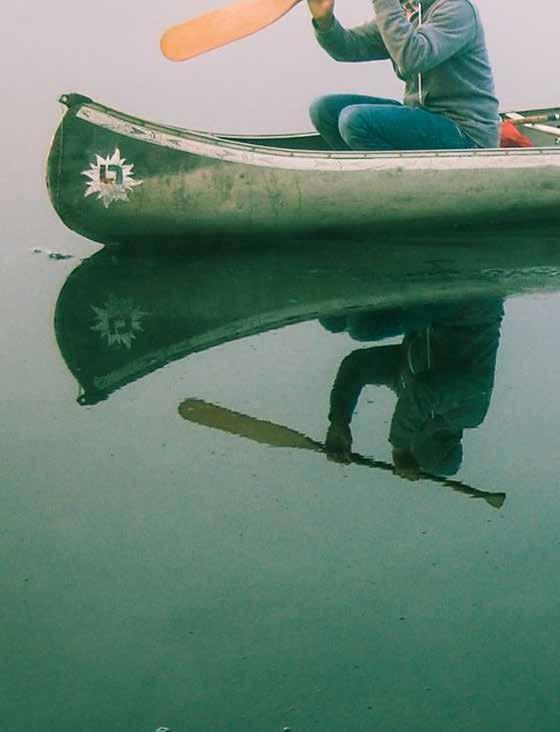
4 Section 1 Executive Summary Background Sherbrooke Lake, located in Lunenburg County, is a 15-minute drive east of the community of New Germany and a 35-minute drive north of Bridgewater. The lake is home to permanent residents, lakefront cottages, and a summer camp; however, it does not currently have a dedicated space for the general public to enjoy the lake. For over three decades the has identified public access to large bodies of water, such as Sherbrooke Lake, as a priority for its recreation network. The Municipality s Council has directed that public access will be developed on Sherbrooke Lake. However, the location and type of access have not yet been determined. Council established the Sherbrooke Lake Access Advisory Committee, a volunteer group of residents and cottage owners, to consult with residents and explore options for the type and location of access. In late 2015 the Sherbrooke Lake Access Advisory Committee recommended UPLAND urban planning + design to act as an independent third party for collecting public feedback on Sherbrooke Lake access. Council supported the Committee s recommendation and hired UPLAND. Methods The Advisory Committee and consultant team conducted a broad public consultation program to collect public feedback on different types of access to Sherbrooke Lake. This included public open houses in Maplewood, New Ross, and Halifax; a focus group with representatives from different governmental agencies who would be involved in regulation and enforcement for public access; and a public survey. The project team widely advertised the public consultation for Sherbrooke Lake. Methods included a project webpage, posters placed around the community, a flyer drop, a direct letter to lake property owners, an list, newspaper ads, and information in municipal newsletters and on municipal websites. The central component of the public consultation program was the survey. The survey was primarily conducted online, but respondents also had the option of filling out a paper survey or calling in for a phone survey. The survey was open to anyone over the age of 15 who was interested in Sherbrooke Lake. Respondents were only permitted to fill out the survey once, although each member of a household was permitted to complete the survey. The raw survey results included 1155 individual responses. UPLAND reviewed the raw results to identify data that required follow-up with the survey respondent. Reasons for follow-up included unclear answers, the appearance of multiple submissions from a single individual, multiple submissions from a single computer, as well as random data checks. The data review resulted in the deletion of 107 records, leaving 1048 records for analysis. This level of feedback is, by many accounts, unprecedented for any public consultation conducted by the. It underscores both the level of interest in the topic of public access on Sherbrooke Lake, and the value of conducting such a broad public consultation program. Consultation Results The survey results showed three distinct (and almost equally-sized) groups of respondents. These groups were Lake Owners, County Residents, and Everyone Else. UPLAND analyzed the rest of the survey with these group divisions in mind, and many of the results are reported for each group separately. UPLAND s analysis of respondent demographics shows that, compared to the general population, people aged 55 to 74 are overrepresented; the Aboriginal population is proportionally-represented; people with annual household incomes of $40,000 to $49,999 are overrepresented, and those with an income of $10,000 to $29,999 are underrepresented; and males are Executive Summary Page iv
5 overrepresented. The survey results indicate that there is indeed interest in using public access on Sherbrooke Lake, with 59 percent of respondents indicating interest. The majority (89 percent) of respondents who are interested in using a public access on Sherbrooke Lake do not already have access to the lake. Activities that were of particular interest to respondents included swimming, non-motorized boating, hiking/walking, fishing (both from a boat and the shore), picnicking, and nature appreciation. The facilities needed to support these activities were reasonably well-supported among respondents, or at the very least, were not particularly controversial. The exception to this are washrooms and facilities that would allow for fishing; both shoreline fishing spots and a boat launch were controversial features that require some thought from the Advisory Committee and Council and additional analysis before they are implemented (or not). If a boat launch is included in the public space, the survey results indicate that a design that accommodates boats of up to 16 feet in length would accommodate approximately two-thirds of the 208 respondents who indicated a desire to use a motorboat or sailboat on Sherbrooke Lake. The upper end of boat size that these respondents wanted to use was 24 feet for motorboats, and 30 feet for sailboats. However, the survey results indicate that boat motor size is not strongly correlated to boat length, so attempting to control motor size by controlling boat length is not likely to be effective. According to the majority of respondents, the public space on Sherbrooke Lake should be accessible to those in wheel chairs or with other mobility challenges. The majority of respondents also felt the space should be open to dogs, but only if they were on a leash; however, approximately one third of respondents felt the public space should not permit dogs at all. The survey results indicate that a public space should have restricted hours of operation, with an 8am opening time and an 8pm or 9pm closing time. Many respondents, particularly Lake Owners, indicated a concern about the risk of disturbance, theft, littering, or vandalism if a public space is opened on Sherbrooke Lake. The public space should include design and operational measures to limit the risk of negative activities. In particular, garbage and recycling bins (with a regular maintenance schedule), signage, and a strong locking gate should all be considered priorities. A common theme in the open houses, in questions about objectives, and in the open-ended questions was that the natural environment of Sherbrooke Lake and its continued health is very important to respondents. Any public space on Sherbrooke Lake should be respectful of the natural environment and be designed to enhance it, rather than harm it. Some respondents provided input to the open-ended questions that included, among other topics, discussions of appropriate scale of access, a desire to see no access at all, the need for public access for people who cannot or do not want to own lake property, examples of good or bad public access, the cost of access, commentary on the survey and consultation process, and discussions of the suitability of specific sites around the lake for access. Open Space Concepts UPLAND used the results of the survey to establish three guiding principles for public access on Sherbrooke Lake and to produce four different design concepts for how public access could be developed. The guiding principles are that public access should have an environmental focus; should be safe, clean, and secure; and should be accessible for all. The four design concepts range from minimal intervention to full build-out. These concepts include Class D cost estimates. The four design concepts and the cost estimates are not attached to any specific location on the lake, but are instead there to help guide the conversation on the scale of public access, and to help the Advisory Committee identify its needs when searching for locations to develop the public access. Class D costing is a very rough level of estimate that provides a ballpark figure for discussing potential development. Once a specific location has been identified and more detailed designs are drawn, the cost estimating can be made more accurate. Executive Summary Page v

![For over three decades the [ the Municipality ] has identified public access to large bodies of water as a priority for its recreation network.](/docs-images/72/67315415/images/6-1.jpg "In 2003 the Municipality developed and adopted its Open Space Strategic Plan. The plan formalized a variety of priorities for acquiring and developing open space recreational land.")
6 Section 2 Introduction Introduction Sherbrooke Lake, located in Lunenburg County, is a 15-minute drive east of the community of New Germany and a 35-minute drive north of Bridgewater. The lake is home to permanent residents, lakefront cottages, and a summer camp; however, it does not currently have a dedicated space for the general public to enjoy the lake. For over three decades the [ the Municipality ] has identified public access to large bodies of water as a priority for its recreation network. In 2003 the Municipality developed and adopted its Open Space Strategic Plan. The plan formalized a variety of priorities for acquiring and developing open space recreational land. Public access to Sherbrooke Lake was identified as a priority. In 2010 the Municipality reviewed and updated the Open Space Strategic Plan to reflect the completion of some projects and to ensure the original priorities were still applicable. The Plan placed access to Sherbrooke Lake as one of the Municipality s top five open space priorities. The Municipality s Council has directed that public access will be developed on Sherbrooke Lake. However, the location and type of access have not yet been determined. Council established the Sherbrooke Lake Access Advisory Committee [ the Committee ] to explore options for the type and location of access. More specifically, the Committee s role is to provide broad based community advice to the Municipality, provide options available for establishing public access to Sherbrooke Lake, and to engage the public using various methods to ensure community input throughout the process of determining public access to Sherbrooke Lake. The Committee is made up of ten volunteers who were appointed by Council. The volunteers were drawn from permanent lake residents, cottage owners, and residents of the larger community. The Committee includes volunteer residents from both the and the Municipality of the District of Chester. Municipal staff act as a resource to the Committee assisting them in fulfilling their mandate, roles, and responsibilities. In late 2015 the Sherbrooke Lake Access Advisory Committee recommended UPLAND urban planning + design to act as an independent third party for collecting public feedback on Sherbrooke Lake access. Council supported the Committee s recommendation and hired UPLAND. This report lays out what we heard. Introduction Page 1

7 ies ies ies Add map of project location Sherbrooke Lake Introduction Page 2
8 Section 3 Media + Awareness Sherbrooke Lake Public Access Consultations We need your help! The Municipality of the District of Lunenburg is exploring different options for developing public access on Sherbrooke Lake. The Committee undertook a significant effort to advertise the Sherbrooke Lake public consultations to both residents of Lunenburg County and people outside of Lunenburg County who might still have an interest in Sherbrooke Lake. These media and awareness efforts included: Project Webpage The Sherbrooke Lake access project was established on its own webpage within the District of Lunenburg ( website. This page included background information on the project, information about upcoming engagement events, and minutes and agendas for Committee meetings. Poster UPLAND produced a poster advertising the online survey and public open houses. The Committee distributed these posters throughout the and the Municipality of the District of Chester at places such as community halls and local coffee shops. Flyer Drop The Committee also contracted Canada Post to deliver the poster to mailboxes in the Municipality of the District of Lunenburg and the Municipality of the District of Chester. Direct Mail Many of the properties around Sherbrooke Lake are cottages, and many of these are owned by people living outside of Lunenburg County, who may not have been reached by the other, more local media and awareness efforts in the winter (i.e. not cottaging) season. To address this concern, the Committee mailed a letter directly to all Sherbrooke Lake owners to notify them of the public consultation efforts, particularly the online survey. List The Municipality reached out to road associations around Sherbrooke Lake. Associations who provided contact information were kept up-to-date on consultation events through notifications. Newspaper The Municipality advertised the survey and open houses through advertisements in the local Lighthouse Now newspaper. Media + Awareness Page 3
9 Municipal Media The Municipality and the Municipality of the District of Chester both placed notices on their municipal websites. The Municipality of the District of Chester also provided information about the project in their municipal newsletter. The local Councillor for the New Ross area advertised the project in the New Ross Flyer. Media + Awareness Page 4

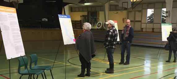
10 Section 4 Consultation Events 4.1 Open Houses UPLAND and the Committee hosted three public open houses for the Sherbrooke Lake access project in February of These open houses were held in Maplewood, New Ross, and Halifax. The open houses included a series of panel displays with information on the project, as well as a series of questions about access with an opportunity to provide feedback on sticky notes. The open houses were a drop-in format, where visitors could view information at their own pace and have faceto-face conversations with the Committee and UPLAND. The open houses were well attended, with 100+ visitors to the Halifax venue, 60+ visitors to Maplewood, and 15 visitors in New Ross. The open house discussions and feedback provided on the display panels mirror, in many ways, the feedback and themes that came through in the survey. For these themes we direct the reader to the survey results later in this report because the survey illustrates the actual number of people who held each opinion better than if they were summarized here. However, there were a few topics of discussion at the open houses that UPLAND believes were not necessarily captured well by the survey, and are best highlighted here: A few attendees mentioned that they were not against public access, per se, but did not want to see the public space accessed through a private road. They were worried about the additional traffic, damage to the road (which they and their neighbours maintain), and the risk of theft if outside vehicles could easily access their land. While not directly tied to public access, some of the attendees discussed overall stewardship of the lake, the need for a formalized lake water quality monitoring program with support from the Municipality, and the need for research into the carrying capacity of the lake and the pressures that different forms of development place on the lake ecosystem. Some attendees used the provided maps to identify specific locations where they know of wildlife (eagle, loon, turtle, spring peeper) habitat. A few cottage owners were concerned that they own land in the municipality and pay taxes, yet they are not eligible to vote in Council elections. Some attendees questioned why the municipality would spend money on creating public access on Sherbrooke Lake and alluded to other needs they thought should be prioritized instead. Some attendees emphasized that the lake itself is a public resource and should not be restricted to private access. Consultation Events Page 5
11 4.2 Focus Group On March 23, 2016, UPLAND facilitated a focus group discussion attended by representatives from the RCMP, Fisheries and Oceans Canada, the NS Department of Fisheries & Aquaculture, Nova Scotia Environment and the NS Department of Natural Resources. The agencies provided substantial and useful insight on the following topics during the 90-minute meeting: Water quality By and large, the water quality in lakes across Nova Scotia has been consistent over the last 100 years. The last water quality report done for Sherbrooke Lake by the NS Department of Fisheries & Aquaculture dates back to 1993 and the water was of very good quality. The department usually samples 8-10 lakes in Nova Scotia every year. The department has very limited money for monitoring water quality. If, however, a lake hasn t been sampled in over 10 years, it is likely that a request for sampling can be accommodated. Nova Scotia Environment has no budget for routine monitoring of water quality. According to the Nova Scotia Environment representative, algae bloom are generally not impacted or increased by boating volumes. Lakeside development is a much bigger concern for water quality due to the nutrient load from failing septic systems, fertilizers, and grey water disposal. Transmitting algae from one lake to another via boat contamination is not a concern because algae transfer is not possible. It is the conditions of a specific lake that cause algae growth. A full algae bloom on Sherbrooke Lake is unlikely because of the low water temperature and the depth of the lake. Fishing, Wildlife and Flora Fisheries and Oceans Canada s (a federal department) only mandate on lakes is to monitor fishing bag limits. Fishing licenses are given out by the Province. Under the Nova Scotia Angling Act, currently any resident of the Province has the right to go on foot along the banks of any river, stream or lake, upon and across any uncultivated lands and Crown lands for the purpose of lawfully fishing with rod and line in such rivers, streams or lakes. (An Act Respecting the Rights of Fishing in Nova Scotia, Section 3(1)). There are only relatively few sport fishing access points across Nova Scotia. Typically, a central boat launch reduces the potential for conflict between landowners and boaters because fewer people use random sites. The NS Department of Fisheries and Aquaculture considers the environmental footprint of one central boat launch to be smaller than those of many small launch points. Invasive fish species emerged in Sherbrooke Lake in 1997 (bass) and 2000 (pickerel). Once invasive species have been introduced to a lake, there is nothing that can be done to eliminate them. The NS Department of Fisheries & Aquaculture used to stock fry but does not do so anymore. Anecdotal information by anglers and locals is considered by the Department as very useful information in assessing fish trends. Bass fishing tournaments need a permit from the NS Department of Fisheries & Aquaculture. The permitting process is an opportunity to place certain conditions on how a tournament is run. According to the representative, bass fishers typically race to a fishing spot at the beginning of a tournament and then remain in one location all day. There are usually no issues with lake residents unless the one-off fisher comes too close to a private wharf or gets in the way of a lake resident angler. Nova Scotia does not have regulations limiting the type and size of boats on a lake. There are however speed limits that can be imposed. Limiting the boat size on a lake could be achieved through the design of the boat launch. The bathymetry of a lake also puts limits on boat types. Recreational fishing is typically done with feet boats. According to the NS Department of Fisheries & Aquaculture representative, wake action from boats has, by and large, no more impact on shorelines than the naturally occurring waves on a lake the size of Sherbrooke Lake. Personal watercraft (Skidoos, etc.) do not create larger waves than motorboats, but the noise they make is often considered a nuisance. Personal watercraft are already being used occasionally on Sherbrooke Lake. There are no known invasive plant species along Sherbrooke Lake. Species-specific questions regarding wildlife should be addressed to the NS Department of Natural Resources office in Kentville. Lake residents observations about declining numbers of frogs and turtles are likely connected to and caused by the pickerel population in Sherbrooke Lake. Consultation Events Page 6
12 Public Safety By and large, the RCMP representative would expect that with new public access to Sherbrooke Lake, call volumes from residents will go up during the summer. The RCMP also handles calls about overdue canoeists and boaters. They have a boat suitable to patrol Sherbrooke Lake. Generally, controlled access, lighting and signage are expected to discourage vandalism. The RCMP also emphasizes the success of citizen patrol groups and community watch signage. Open Space Design If public access to Sherbrooke Lake was to be developed, the NS Department of Fisheries & Aquaculture would like to be involved in the draft design process. The department also offered to give municipal staff a tour of comparable facilities on other lakes in Nova Scotia. Small financial contributions may be available through the Nova Scotia Sportfish Habitat Fund. Fishing typically starts 2 hours before dawn and ends 2 hours after dusk. During that time any boat ramps should be accessible. The fishing season ends on October 31. The representative from the NS Department of Fisheries and Aquaculture considered Aylesford Lake in Kings County as a successful example that the Municipality should study. There are currently no known boat launch protocols in Nova Scotia. Creating public access to Sherbrooke Lake could be an opportunity for the Municipality to create the first boat launch protocol in the province. Slope and characteristics of substrate are the most important factors in determining suitable sites for boat launches. Leeward and sheltered shores are preferable. The flushing system of a particular lake portion is not considered to impact the water quality with respect to the location of a boat launch. Nova Scotia Environment would be pleased to assist in groundtruthing potential access points. They can also help determining which permits are needed for a specific site as this might impact the timeline and capital budget for implementation. When choosing a site for public access, the Municipality should not only consider current user needs but also think about the long-term use. The design of the site offers an opportunity to set a high standard for the province. Consultation Events Page 7

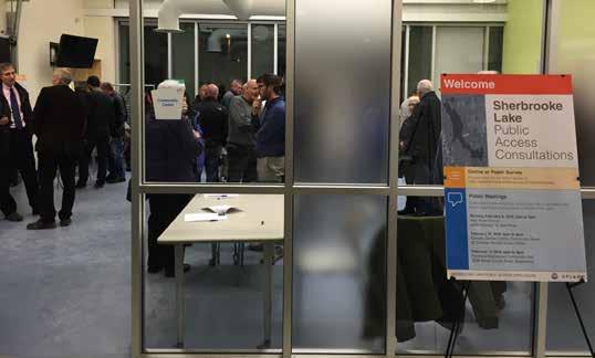
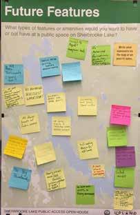
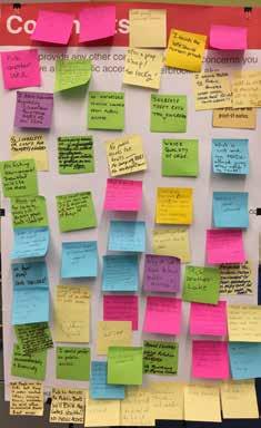
13 Open House Consultations Consultation Events Page 8
14 Section 5 Survey A central component of the Committee s public engagement efforts was the Sherbrooke Lake Access Survey. UPLAND conducted this survey from January 25 to February 28, Method UPLAND produced the Sherbrooke Lake Access Survey with a series of questions designed to gain an understanding of what kind of access respondents believe should be provided on Sherbrooke Lake. A copy of the survey is attached to this report as Appendix C. The survey was open to anyone aged 15 or older who was interested in the topic of Sherbrooke Lake access, and was not limited to just residents of Lunenburg County. The survey was primarily conducted as a self-selecting, online survey. UPLAND utilized the SimpleSurvey platform to conduct the online version of the survey. This platform hosts its data on Canadian servers. UPLAND designed the survey to use branching logic to serve only those questions applicable to the respondent based on previous question answers. Due to concerns that some potential respondents may lack internet access, UPLAND also designed a paper copy of the survey. Paper copies were made available at the Municipality s offices, as well as at the open houses. The survey team numbered each copy of the survey that was given out in order to deter photocopying of the survey and to track the number of paper surveys released. The survey instructions told respondents to return the survey directly to UPLAND, rather than to the Municipality. UPLAND staff manually entered the received paper surveys into the online survey platform. UPLAND received a total of 71 completed paper surveys. UPLAND also offered an option for a phone survey if respondents had physical challenges filling out the online or paper survey. UPLAND conducted 4 phone surveys. The raw survey results included 1155 individual responses. UPLAND reviewed the raw results to identify data that required follow-up with the survey respondent. Reasons for follow-up included unclear answers, the appearance of multiple submissions from a single individual, multiple submissions from a single computer, as well as random data checks. In most cases the data were confirmed to be accurate and within the rules of the survey (i.e. one submission per individual). However, some submissions were confirmed for deletion; in most cases these were simply cases where an individual had started the survey but did not finish it, and then came back at a later date and started a new survey rather than continuing Survey Page 9
15 the partially-completed survey. The data review resulted in the deletion of 107 records, leaving 1048 records for analysis. Following the completion of UPLAND s role in the Sherbrooke Lake project, UPLAND deleted all identifying personal information (IP address, first name, phone number, aboriginal status) from all instances of the survey results. 5.2 Limitations 1. The Sherbrooke Lake Access Survey was a self-selecting survey. The survey was open to all people interested in filling it out, rather than controlled to ensure respondents represented a statistically-representative segment of the general population. This means that the results of the survey only represent the opinions of the people who responded to the survey, and cannot be generalized to say anything about the opinions of a bigger population (e.g. all lake owners, all people in Lunenburg County, etc.). Survey Page 10
16 5.3 Survey Results Location UPLAND located respondents based on their postal code forward sortation area (the first three digits) or the respondent s description of their location. This method is a higher-level approach to location that avoids the risk of identifying the exact street on which a respondent lives. The geolocation of respondents highlighted three distinct (and almost equally-sized) groups: Lake Owners 343 Respondents Respondents who reported owning land on Sherbrooke Lake. The Sherbrooke Lake land did not need to be the respondent s primary address. County Residents 353 Respondents Respondents who have their primary address in Lunenburg County but who did not report owning land on Sherbrooke Lake. Everyone Else 352 Respondents Anyone not included in the first two groups Further analysis indicated that answers to the other survey questions were often different from one group to the next. For this reason, and for its usefulness in making policy decisions, UPLAND analyzed the rest of the survey with these group divisions in mind, and many of the following results are reported for each group separately. Demographics UPLAND compared the results of the demographic questions on the survey to Statistics Canada 2011 census data to better understand who the survey had reached (Figures 1, 2, & 3). This analysis was only conducted for respondents with their primary residence in Lunenburg County, because this was the only population of respondents that had a defined boundary to align with Statistics Canada census boundaries. The demographic comparison indicates that within the residents of Lunenburg County who completed the survey: People aged 55 to 74 are overrepresented, with other age groups underrepresented. Youth, young adults, and seniors aged 80+ are particularly underrepresented. The Aboriginal population is proportionally-represented. Many household income brackets are reasonably well represented. The exceptions are those with an income of $40,000 to $49,999 (overrepresented) and those with an income of $10,000 to $29,999 (underrepresented). Males are overrepresented and females are underrepresented. Survey Page 11
17 Percentage of Population 20% 15% 10% 5% 0% Survey Respondents Census Age Group Figure 1: The age group of survey respondents from Lunenburg County compared to 2011 census counts of age for all residents of Lunenburg County Percentage of Population 25% 20% 15% 10% 5% 0% Under $10,000 Survey Respondents $10,000 to $14,999 $15,000 to $19,999 $20,000 to $29, Census $30,000 to $39,999 $40,000 to $49,999 $50,000 to $74,999 Annual (before tax) Household Income $75,000 to $99,999 $100,000 to $149,999 $150,000 and up Figure 2: The annual household income of survey respondents from Lunenburg County compared to 2011 census counts of household income for all residents of Lunenburg County Survey 2011 Census 38.4% 61.6% Male Female 51.5% 48.5% Figure 3: The biological sex of survey respondents from Lunenburg County compared to 2011 census counts of biological sex for all residents of Lunenburg County Survey Page 12
18 Current Access to Sherbrooke Lake Figure 4 displays the level of access respondents currently have to Sherbrooke Lake. Most respondents who identified as Lake Owners currently have some form of access to the lake itself, in most cases by owning waterfront property. The large majority of non-owner County Residents report not currently having any form of access to the lake. Among Everyone Else, 70 percent of respondents do not currently have access to Sherbrooke Lake Do you currently have access to Sherbrooke Lake? Lake Owners (n=341) County Residents (n=351) Everyone Else (n=349) Number of Respondents No 0 Yes, I own waterfront property Yes, I have an agreement with a waterfront owner to use their land Yes, I am part of a subdivision that has community water access for back lot owners 12 7 Yes, I have some other type of arrangement that legally gives me water access Figure 4: Respondents current level of access to Sherbrooke Lake Survey Page 13
19 Consider Using Access When asked if they would consider using a public space on Sherbrooke Lake, if it was available, 59 percent of respondents indicated, yes (Figure 5). Within the group of respondents who answered, no, 89 percent already have access to Sherbrooke Lake. Other reasons given for not wanting to use a public space on Sherbrooke Lake fell into the following categories: Adequate access to other recreation areas The lake is too far away from the respondent Belief that the public space would be too crowded or otherwise undesirable Do not want to impact the lake Do not want to impact current lake owners Do not participate in lake activities 700 Would you consider using public space on Sherbrooke Lake, if the option was available? Number of Respondents Do Not Have Access Have Access Yes No Figure 5: Respondents interest in using a public space on Sherbrooke Lake Survey Page 14
20 Desired Activities The survey asked respondents who were interested in using a public space on Sherbrooke Lake about what types of activities they would want to do in the public space. Very popular activities include swimming, non-motorized boating, hiking/ walking, fishing (both from a boat and the shore), picnicking, and nature appreciation (Figure 6). Other activities that respondents suggested included: Cycling Ultralight float plane access Foraging Ice fishing Playing on a playground Snowmobiling Playing tennis, soccer, basketball, and other sports Access for remote control vehicles Campfires What kinds of activities would you, personally, want to use the public space for? Swimming Non-motorized boating Hiking / walking Fishing from a boat Picnicking Nature appreciation Fishing from the shore Bird watching Reading, yoga, sunbathing, and/or relaxing Camping Ice skating Show shoeing Cross-country skiing Power boating, water skiing, and/or wake boarding 94 Badminton, volleyball, Frisbee, and/or other sports Painting, art, and/or photography Ice sailing Number of Respondents Figure 6: Types of activities respondents would want to do in a public space on Sherbrooke Lake Survey Page 15
21 Seasons The survey also asked potential public space users the seasons in which they would want to use the space. Respondents identified summer as the most desirable season; however, respondents were also very interested in spring and fall, and there was even some interest in winter use (Figure 7). When reviewing the results by group (Figure 8), only about 55 percent of Lake Owners would use the public space in spring and fall, while approximately 78 percent on non-owners would use the public space in those seasons. Proportional interest in the space for the summer and winter seasons was almost identical between those two groups. In which season(s) would you, personally, want to use the public space? 700 Number of Respondents Spring Summer Fall Winter Figure 7: Total number of respondents who would want to use a public space on Sherbrooke Lake, by season Percentage of Respondents 100% 90% 80% 70% 60% 50% 40% 30% 20% 10% 0% Lake Owners County Residents Everyone Else Spring Summer Fall Winter Figure 8: Percentage of respondents who would want to use a public space on Sherbrooke Lake, by season. Percentages total to more than 100 percent because respondents could indicate interest in more than one season Survey Page 16
22 Boat Size The survey asked the respondents who were interested in using a public space what (if any) would be the largest size of boat they would want to use. The highest desire for watercraft use is for canoes or kayaks, followed by motorboats (Figure 9). Respondents who indicated they wanted to use a motorboat or sailboat were then asked to provide a specific length for the boat they would want to use. The online version of the survey initially had a small error that directed all respondents to this question, even if they indicated they did not want to use public space on Sherbrooke Lake. UPLAND quickly corrected this issue, but not before some respondents had mistakenly filled out this question. In these cases, UPLAND removed the responses (to this question only) from the analysis. Figure 10 shows the results for the 208 respondents who provided the length of their boat. Two extreme outlying responses 100 and 162 are not plotted on Figure 10. If Council does decide to develop a boat launch, approximately two-thirds of the 208 respondents could be accommodated with a launch for boats that are 16 and shorter. The upper end (ignoring the extreme outliers) for respondents motorboat size was 24, and 30 for sailboats. Figure 11 displays a plot of desired motorboat motor size (in horsepower) compared to the respondent s desired boat size (in feet). While motor size does tend to increase with boat length, the correlation is somewhat weak (R 2 = 0.48), and shorter boats could still have larger motors. This suggests that any effort to use the design of a boat launch to limit boat length in an effort to indirectly limit motor size would only be mildly effective. What is the largest size of boat you would want to use on Sherbrooke Lake? 300 Lake Owners (n = 44) County Residents (n = 309) Everyone Else (n = 243) Total (n = 605) Number of Respondents I do not want to use a boat Canoe / kayak Personal watercraft (Jet Ski, See-Doo, etc.) Motorboat Sailboat Figure 9: Largest boat size respondents would want to use on Sherbrooke Lake Survey Page 17
23 60 50 Motorboat Sailboat Number of Respondents ' 13' 14' 15' 16' 17' 18' 19' 20' 21' 22' 23' 24' 25' 26' 27' 28' 29' 30' Desired Boat Length Figure 10: Largest boat length respondents would want to use on Sherbrooke Lake Motor Size (HP) R² = Boat Length (feet) Figure 11: Respondents desired motor size plotted as a function of desired boat length Survey Page 18
24 Features From this point forward, the survey asked every respondent the full list of questions. The survey asked respondents to indicate what types of features of amenities they would want to have or not have at a public space on Sherbrooke Lake. The survey asked respondents to rate each possible feature on a scale that included a text statement and associated score, as follows: Would strongly not want to have (-2) Would not want to have (-1) Neutral (0) Would want to have (+1) Would strongly want to have (+2) Figures 12 to 29 are bar graphs that show how respondents scored each feature. Some features show a clear majority of people who are in favor of them and are clear candidates to develop at a public space on Sherbrooke Lake. These include garbage & recycling bins, a canoe/kayak dock, hiking trails, a picnic area, and a beach. Some features received consistently lower scores and should probably not be developed at Sherbrooke Lake. These include a canteen, observation decks, a lifeguard, and outdoor BBQ grills. Interpretive panels, an open space or field, picnic shelters, a playground, a floating swimming dock, and change rooms all fell into the category of features where respondents did not feel particularly strong one way or another. These features could either be included or left out, depending on the final constraints of the site and budget, without causing too much concern one way or another. The challenging features are those that had lots of respondents strongly against them and lots of respondents strongly in favour of them. Shoreline fishing spots, washrooms, and especially a boat launch were the three items that clearly fell into this category. These features in particular require some thought around Council and additional analysis before they are implemented (or not). Survey Page 19
25 Appendix A - Plots of Respondents Preferences for Different Types of Features Beach Number of Respondents Lake Owners County Residents Everyone Else Total Total who would not want to have: 220 Feature Score Total who would want to have: 557 Figure 12: Respondents preference for a beach at Sherbrooke Lake Boat Launch Number of Respondents Lake Owners County Residents Everyone Else Total Total who would not want to have: 465 Feature Score Total who would want to have: 397 Figure 13: Respondents preference for a boat launch at Sherbrooke Lake Canoe/Kayak Dock Number of Respondents Lake Owners County Residents Everyone Else Total Total who would not want to have: 201 Feature Score Total who would want to have: 561 Figure 14: Respondents preference for a canoe/kayak dock at Sherbrooke Lake Survey Page 20
26 Canteen (Concession Stand) Number of Respondents Lake Owners County Residents Everyone Else Total Total who would not want to have: 568 Feature Score Total who would want to have: 148 Figure 15: Respondents preference for a canteen at Sherbrooke Lake Change Rooms Number of Respondents Lake Owners County Residents Everyone Else Total Total who would not want to have: 348 Feature Score Total who would want to have: 361 Figure 16: Respondents preference for change rooms at Sherbrooke Lake Floating Swimming Dock Number of Respondents Lake Owners County Residents Everyone Else Total Total who would not want to have: 291 Feature Score Total who would want to have: 411 Figure 17: Respondents preference for a floating swimming dock at Sherbrooke Lake Survey Page 21
27 Number of Respondents Garbage & Recycling Bins 572 Lake Owners County Residents Everyone Else Total Total who would not want to have: 171 Feature Score Total who would want to have: 758 Figure 18: Respondents preference for garbage and recycling bins at Sherbrooke Lake Hiking Trails Number of Respondents Lake Owners County Residents Everyone Else Total Total who would not want to have: 228 Feature Score Total who would want to have: 522 Figure 19: Respondents preference for hiking trails at Sherbrooke Lake Interpretive Panels Number of Respondents Lake Owners County Residents Everyone Else Total Total who would not want to have: 301 Feature Score Total who would want to have: 259 Figure 20: Respondents preference interpretive panels at Sherbrooke Lake Survey Page 22
28 Lifeguard Number of Respondents Lake Owners County Residents Everyone Else Total Total who would not want to have: 365 Feature Score Total who would want to have: 189 Figure 21: Respondents preference for a lifeguard at Sherbrooke Lake Observation Decks Number of Respondents Lake Owners County Residents Everyone Else Total Total who would not want to have: 393 Feature Score Total who would want to have: 187 Figure 22: Respondents preference for observation decks at Sherbrooke Lake Open Space or Field Number of Respondents Lake Owners County Residents Everyone Else Total Total who would not want to have: 352 Feature Score Total who would want to have: 271 Figure 23: Respondents preference for an open space or field at Sherbrooke Lake Survey Page 23
29 Outdoor BBQ Grills Number of Respondents Lake Owners County Residents Everyone Else Total Total who would not want to have: 445 Feature Score Total who would want to have: 279 Figure 24: Respondents preference for outdoor BBQ grills at Sherbrooke Lake Picnic Area Number of Respondents Lake Owners County Residents Everyone Else Total Total who would not want to have: 280 Feature Score Total who would want to have: 536 Figure 25: Respondents preference for a picnic area at Sherbrooke Lake Picnic Shelters Number of Respondents Lake Owners County Residents Everyone Else Total Total who would not want to have: 342 Feature Score Total who would want to have: 355 Figure 26: Respondents preference for picnic shelters at Sherbrooke Lake Survey Page 24
30 Playground Number of Respondents Lake Owners County Residents Everyone Else Total Total who would not want to have: 377 Feature Score Total who would want to have: 274 Figure 27: Respondents preference for a playground at Sherbrooke Lake Shoreline Fishing Spot Number of Respondents Lake Owners County Residents Everyone Else Total Total who would not want to have: 327 Feature Score Total who would want to have: 391 Figure 28: Respondents preference for a shoreline fishing spot at Sherbrooke Lake Washroom Facilities Number of Respondents Lake Owners County Residents Everyone Else Total Total who would not want to have: 246 Feature Score Total who would want to have: 632 Figure 29: Respondents preference for washroom facilities at Sherbrooke Lake Survey Page 25
31 The survey gave respondents an opportunity to list other features that were not included in the given list. These additional features are listed below. Would Strongly Want to Have (+2) A dock for boaters to take on passengers (1 respondent) Barrier-free access (1 respondent) Bicycle trails (1 respondent) Boat/hull washing station (2 respondents) Composting toilets (1 respondent) Small, inconspicuous access points rather than large park (2 respondents) If washroom facilities are included, make sure they drain away from the lake (1 respondent) Benches (1 respondent) Parking (10 respondents) Powered camp sites with a comfort station (1 respondent) Prohibition on power boats (4 respondents) Would Want to Have (+1) Simple games for families and older people, with an instructor (1 respondent) Bicycle racks (1 respondent) Composting toilet/outhouse if a bathroom is required (1 respondent) Fenced off-leash dog area (1 respondent) Parking (3 respondents) Neutral (0) Access for tournament fishing (1 respondent) Access for boats with engines larger than 35 hp (1 respondent) Outhouses (1 respondent) Trails (1 respondent) Would Not Want to Have (-1) A simple playground (1 respondent) Would Strongly Not Want to Have (-2) Any public access (14 respondents) Gated parking area that requires users to park and walk to the public space, with direct, accessible access for people who need it (1 respondent) Fire pits (3 respondents) Fishing tournaments (2 respondents) Garbage that attracts wildlife (1 respondent) Motorized boats (3 respondents) Camping / overnight facilities (1 respondent) Trails or roads that connect to the private developments around the lake (1 respondent) Access should be a small picnic area and beach, similar to Aylesford Lake (1 respondent) Need to map rocks in the lake (1 respondent) Survey Page 26
32 Accessibility The large majority of respondents felt that a public space on Sherbrooke Lake should be designed to be accessible for people in wheelchairs or with other mobility challenges (Figure 30). Number of Respondents In your opinion, how important is it for the public space to be accessible for people in wheelchairs or with other mobility challenges? Lake Owners (n = 333) County Residents (n = 349) Everyone Else (n = 332) Not at all important 28 Total Extremely important No opinion Figure 30: The level of importance placed by respondents on making a public space physically accessible Dogs Respondents were somewhat divided on whether or not a public space on Sherbrooke Lake should permit dogs (Figure 31). Of respondents with an opinion on dogs, 68 percent were in favour of allowing them, and 32 percent were against. If dogs are permitted, the clear desire is to require them to be leashed at all times. Support for dogs was much lower among Lake Owners when compared to the other groups. In your opinion, should the public space on Sherbrooke Lake permit dogs? Number of Respondents Lake Owners (n = 338) County Residents (n = 352) Everyone Else (n = 333) Total Yes Yes, but only if they are on a leash No 313 No opinion 52 Figure 31: Respondents opinion of whether or not a public space on Sherbrooke Lake should permit dogs Survey Page 27
33 Opening Hours The majority of respondents believe that access to Sherbrooke Lake should be limited to specific hours of the day (Figure 32). This belief is particularly strong among Lake Owners, although all three groups showed majority support for implementing hours of operation. Among those supporting hours of operation, 8:00am was the most popular opening hour, and 8:00pm (closely followed by 9:00pm) was the most popular closing hour (Figure 33). In your opinion, should public access to Sherbrooke Lake be limited to certain hours of the day? Number of Respondents Lake Owners (n = 333) County Residents (n = 352) Everyone Else (n = 333) Total (n = 1018) Yes No No opinion Figure 32: Respondents preference on whether or not public access should have hours of operation Please choose the time of day you think public access should open and the time of day you think it should close Number of Respondents Open Close Figure 33: Respondents preferred open and closing times for public access on Sherbrooke Lake Survey Page 28
34 Enforcement The survey asked respondents to indicate whether or not they supported different methods for enforcing rules in a Sherbrooke Lake public space. Signage was the most popular method, with 92 percent support and reasonably consistent support among all three groups (Figure 34). Staff supervision was the least popular method, particularly among County Residents. Lake Owners showed strong support for all methods. Other suggestions for enforcement methods included: Fines for littering Boat patrol Fencing around the whole public space RCMP/law enforcment patrols Entrance fees Survey Page 29
35 In your opinion, should the following methods be used to enforce the public space rules, including hours/seasons of operation (if applicable)? Total Gate (n = 859) Everyone Else County Residents Lake Owners 0% 10% 20% 30% 40% 50% 60% 70% 80% 90% 100% Total Lighting (n = 759) Everyone Else County Residents Lake Owners 0% 10% 20% 30% 40% 50% 60% 70% 80% 90% 100% Security Cameras (n = 770) Total Everyone Else County Residents Lake Owners 0% 10% 20% 30% 40% 50% 60% 70% 80% 90% 100% Total Signage (n = 895) Everyone Else County Residents Lake Owners 0% 10% 20% 30% 40% 50% 60% 70% 80% 90% 100% Staff Supervision (n = 690) Total Everyone Else County Residents Lake Owners 0% 10% 20% 30% 40% 50% 60% 70% 80% 90% 100% Percentage of Respondents Yes No Figure 34: Respondents support for different methods of enforcing public space rules at Sherbrooke Lake Survey Page 30
36 Objectives The survey asked respondents to select up to three statements that indicated their most important objectives for public access on Sherbrooke Lake (Figure 35). Lake Owners placed a priority on the natural environment, water quality, and safety for users and cottage owners. County Residents placed a priority on providing access for future generations, the natural environment, and opportunities for physical activity. Everyone Else placed a priority on the natural environment, water quality, and providing public access for future generations. Respondents also had the opportunity to provided alternate statements of their own. Statements in quotation marks and italics are direct quotes and UPLAND has not edited them: Variations of comments asking for no public access on Sherbrooke Lake (26 respondents) To preserve water quality and restrict the number of power boats that would impact the loon population They are all important There should be no engine driven watercraft Public boat launch Provide a natural environment for individual fisherpersons to enjoy a pleasurable day to quietly fish on the lake (not necessarily in a fishing tournament environment.). and in that way be able to pursue the fishing sport on what is undoubtedly the best lake in all of Nova Scotia. Provide a family day park to make our rural communities better places to live, to grow and to prosper Prohibit access for fishing tournaments Preserve tranquility of present lake owners No one owns the water in NS, there for eveyone! Keep the lake pristine as it is today I do not support access on this lake, but if built, Should be well separated by a large distance buffer from existing cottage/home owners / approximately 1km on each side of the access location Help sustain & grow local communities & make them better places to live Help build our communities for families Encourage rehabilitation of the natural environment. Enable people to launch motorized and/or non motorized boats to enjoy the big lake Effective policing (both land and water) Due not have a large boat ramp to the water / due not permit gas motor boats of any kind, use electric motors only Create a boat launch Being able to launch a trailered boat and have parking Be brought to a council of all users for appropriate consulattion Be able to launch my boat or kayak or canoe so i can go fishing on this lake with family and friends that is owe by all Nova Scotia s NOT the cottages/home owners witch is what is happing around OWE Lakes here in NS Allow year round access for water activities Allow access for people to go fishing from a boat, not necessarily tournament fishing All of the above works for me All lakes in N.S. need boat launches and public access for every Nova Scotian Aim -- as much as possible -- to maintain the quality of the lake s natural environment, without keeping the general public from accessing it Survey Page 31
37 A public space on Sherbrooke Lake should... Be designed to preserve the natural environment 608 Be designed to preserve lake water quality 402 Provide public access for future generations 297 Be safe for users and cottage owners 289 Provide people with opportunities for quiet, passive recreation 261 Provide people with opportunities for physical activity and exercise Be designed to emphasize the natural beauty of the lake Connect local communities with the water Total Lake Owners County Residents Be a place to gather with friends 104 Everyone Else Provide access for fishing tournaments 68 Encourage tourism 52 Be a space for community events (Canada Day, corn boils, etc.) Educate visitors about the history and environment of the lake Contribute to local economic development Number of Responses Figure 35: Respondents top objectives for a successful public space at Sherbrooke Lake Survey Page 32
38 Vision The survey provided respondents an opportunity to write out their vision for a successful public space on Sherbrooke Lake. This questions received 721 responses in an open-ended format. UPLAND edited the responses to remove information that might identify the writer (typically names), but otherwise left these responses as direct quotes. The full collection of responses is attached to this report as Appendix A. UPLAND has produced a qualitative summary of the themes that came up in response to this question. The responses include a wide range of viewpoints and many nuances that cannot be accurately conveyed in a summary. UPLAND encourages the reader to carefully read through all of the responses in the appendix. UPLAND also cautions that the below summary is qualitative in nature and does not analyze how many comments were made for each theme. The reader should refer to the analysis of previous survey questions to better understand the weight of different viewpoints. Scale of Access The majority of comments indicated that some scale of access could be acceptable, and then described the respondent s ideal level of access development. Respondents vision of access development ranged from a single walking trail to the lake and a kayak put-in spot on the shore; to a park space with swimming and picnic areas; to full-scale access with a boat launch. UPLAND directs the reader to the survey question on features for a better understanding of level of support for different public space features. One common comment was that public access is okay, as long as it does not allow motorized boats. Some respondents did, however, indicate a desire to use motorized boats. Some respondents also specifically mentioned that public access should not enable fishing tournaments. A few participants specifically mentioned a desire to participate in fishing tournaments. Two common themes among respondents was that the public access should be family-friendly and/or rustic. Other comments on the scale of access were related to specific design aspects. In particular, a few comments suggested that access should only come from a public street (i.e. not from an existing private road) and that the public access should be buffered from existing residential development. Many respondents also indicated that access should be usable by those in wheelchairs or with other mobility challenges, and appropriate for all ages. No Access A good number of comments indicated that their vision is to have no public access at all on Sherbrooke Lake. A few respondents said they were disappointed the survey did not have a question directly asking if people wanted to have public access on the lake. Sensitivity to the Environment A large number of respondents commented on the natural environment of Sherbrooke Lake. Environmental topics included water quality (including pollution and algae), the riparian area along the shore, and wildlife (loons, fish, osprey, and eagles). Some respondents see the natural environment as a reason not to develop public access, while others see it as the reason people would want to use public access. However, the majority of comments on the natural environment raised it as something that needs to be carefully considered in the design of any public space. A few respondents requested that the Municipality become involved in environmental monitoring, such as water quality testing and surveys of invasive species. Management Many comments touched on the topic of management. A good number of these comments highlighted specific concerns, such as littering, vandalism, theft, noise, public intoxication, loss of privacy, and dangers to boaters from hidden rocks in the water. Many comments provided suggestions for addressing concerns, such as regular maintenance and emptying of solid Survey Page 33
39 waste bins, clear rules with appropriate enforcement, and restricted hours/seasons of operation. Some respondents also requested restrictions on the size of boat motors. Need for Public Access A large number of respondents emphasized that lakes are a public resource in Nova Scotia, and that no one can privately own Sherbrooke Lake. Many respondents were concerned about the general loss of public access to lakes in Nova Scotia over the years, and the specific loss of public access to Sherbrooke Lake in the past few decades. Some respondents highlighted the fact that not all people can afford the luxury of a private lot or cottage, or that many people do not have the desire to own a cottage, yet still wish to access water. Other Examples A handful of respondents highlighted public access points on other lakes as specific examples of what works or what should be avoid. In many cases one respondent would suggest a lake as a good example, while another respondent would use the very same lake as example of what not to do at Sherbrooke. Lakes and access points that were identified and might be worth studying include Mush-a-Mush, Aylesford, Carters Beach, Indian Falls, Petite Rivière Community Park, Hirtles Beach, and Oakfield Park on Grand Lake. Cost A few respondents were concerned about how much money it could cost to develop public access on Sherbrooke and who would pay for it. A couple of respondents suggested charging a user fee to use the access. General Comments The survey provided respondents an opportunity to write out any other general comments, ideas, or concerns they may have about public access on Sherbrooke Lake. This question received 550 responses in an open-ended format. UPLAND edited the responses to remove information that might identify the writer (typically names), but otherwise left these responses as direct quotes. The full collection of responses is attached to this report as Appendix B. UPLAND has produced a qualitative summary of the themes that came up in response to this question. The responses include a wide range of viewpoints and many nuances that cannot be accurately conveyed in a summary. UPLAND encourages the reader to carefully read through all of the responses in the appendix. UPLAND also cautions that the below summary is qualitative in nature and does not analyze how many comments were made for each theme. The reader should refer to the analysis of previous survey questions to better understand the weight of different viewpoints. The themes that came through in the general open-ended questions were very similar to those that came through in the open-ended question about vision. UPLAND directs the reader to those themes that are laid out above. However, the responses to the general question included two additional themes that did not show up in the vision question: The Survey and Process Many respondents commented on the survey and the process surrounding the public access on Sherbrooke Lake. The large majority of these comments were thankful for the survey and the opportunity to provide their thoughts on access. However, some respondents did feel like the process skipped a step because it did not first ask respondents if they wanted to see public access on Sherbrooke Lake or not. Some respondents also felt the survey should have included information or questions on the financial impact of developing public access. Specific Sites Some of the comments touched on specific sites for access. In some cases, these comments asked where the access would be or suggested that answering the survey was difficult without knowing a proposed location for the access. Other respondents provided their thoughts on the suitability of specific locations, with the most commonly-discussed site being the location at the end of Veinotte Road. Some comments were supportive of access at this location, while others were strongly against access there. Survey Page 34
40 5.4 Conclusion The survey received 1048 valid responses, which represents a strong level of interest in the topic of public access at Sherbrooke Lake. These responses were well-suited for analysis based on three population groups of almost equal size: Lake Owners, County Residents, and Everyone Else. The survey results indicate that there is indeed interest in using a public space on Sherbrooke Lake, especially among respondents who do not already have access to the lake. Activities that were of particular interest to respondents included swimming, non-motorized boating, hiking/walking, fishing (both from a boat and the shore), picnicking, and nature appreciation. The facilities needed to support these activities were reasonably well-supported among respondents, or at the very least were not particularly controversial. The exception to this are washrooms and facilities that would allow for fishing; both shoreline fishing spots and a boat launch were controversial features that require some thought from the Advisory Committee and Council and additional analysis before they are implemented (or not). If a boat launch is included in the public space, the survey results indicate that a design that accommodates boats of up to 16 feet in length would accommodate approximately two-thirds of the 208 respondents who indicated a desire to use a motorboat or sailboat on Sherbrooke Lake. The upper end of boat size that these respondents wanted to use was 24 feet for motorboats, and 30 feet for sailboats. However, the survey results indicate that boat motor size is not strongly correlated to boat length, so attempting to control motor size by controlling boat length is not likely to be effective. According to the majority of respondents, the public space on Sherbrooke Lake should be accessible to those in wheel chairs or with other mobility challenges. The majority of respondents also felt the space should be open to dogs, but only if they were on a leash; however, approximately one third of respondents felt the public space should not permit dogs at all. The survey results indicate that a public space should have restricted hours of operation, with an 8am opening time and an 8pm or 9pm closing time. Many respondents, particularly Lake Owners, indicated a concern about the risk of disturbance, theft, littering, or vandalism if a public space is opened on Sherbrooke Lake. The public space should include design and operational measures to limit the risk of negative activities. In particular, garbage and recycling bins (with a regular maintenance schedule), signage, and a strong locking gate should all be considered priorities. A common theme in the open houses, in questions about objectives, and in the open-ended questions was that the natural environment of Sherbrooke Lake and its continued health is very important to respondents. Any public space on Sherbrooke Lake should be respectful of the natural environment and be designed to enhance it, rather than harm it. As previously stated, the large volume of responses to the survey is a good indicator of the level of public interest there is concerning public access to Sherbrooke Lake. The information contained in this reports reflects the views of the public that responded and provides the Committee and Council with good information to guide them in making future recommendations and decisions concerning the designs and features of public access to Sherbooke Lake. Survey Page 35
41 Survey Page 36

42 Section 6 Open Space Concepts 6.1 Guiding Principles An Environmental Focus The survey results indicate a strong respect for the natural environment of Sherbrooke Lake. All three groups in the survey recognized a need to protect the lake s natural environment, but also expressed the value of accessing that natural environment for personal enjoyment (whether through private or public access). Like any lakeshore development, public amenities can be developed with wildly different levels of sensitivity to the existing natural landscape. UPLAND recommends that public access on Sherbrooke Lake be developed with a focus on harmony with the existing natural environment. In particular, the final design should: Minimize the removal of native vegetation, particularly in the riparian zone along the water Carefully manage stormwater runoff Provide an adequate distance between human waste disposal (pit privies or septic fields) and the lake Investigate a hull wash station at the boat launch (if a boat launch is developed) Safe, Clean, & Secure A common concern UPLAND heard from Lake Owners in the survey results and at open houses was that public access on Sherbrooke Lake could impact enjoyment of their property by increasing noise, increasing traffic and wear-and-tear on private roads, and raising the risk of break-ins during the off-season. The other respondent groups also showed a strong preference for a space that is safe and clean; indeed, garbage & recycling bins was the public space feature that had the highest level of support among all respondent groups. UPLAND recommends that the Municipality prioritize developing a public space on Sherbrooke Lake that is safe, clean, and secure. In particular, the final design should: Gain its access directly from a public street, rather than through an existing private road Be buffered from existing residential development by as much natural vegetation as possible Have controlled hours of operation Be gated with a robust gate to prevent vehicular access during off-hours and in off-seasons Include garbage and recycling bins, with a regular schedule for emptying them Open Space Concepts Page 37
43 Accessible for All Public access on Sherbrooke Lake should by its very definition as public be accessible to everyone, regardless of their age, income, gender, race, or physical ability. The main area that requires attention in this regard is ensuring the final design of the space does not exclude people in wheelchairs or with other mobility challenges. UPLAND recommends that the the core features of the public space be designed to modern barrier-free standards. This view is supported by the majority of survey respondents. 6.2 Open Space Design Options Based on the outcomes of the public consultation process and the Guiding Principles, UPLAND developed four high-level open space concepts for Sherbrooke Lake (pages 39-46). The concepts build from a lower level of intervention up to a full build-out with a public beach and boat launch. These open space concepts are not tied to a specific plot of land - rather, they generic spaces to help guide the Committee s discussion on suitable pieces of land for a public access. As the Committee and Council refine the design of the public access they will be able to mix-and-match different features from the four concepts. Although not specifically shown on the concepts, any final design should include garbage and recycling bins that are regularly maintained, and signage that shows users the rules for the public space. Concept 1 The first concept is minimal intervention that provides simple access to the water. Parking is provided next to the road, and then users access the lake through a walking trail. The lakeshore access itself features a low level of development where users could put in a small canoe or kayak, fish from the shore, or perhaps swim from the shore. Wayfinding and interpretive signage helps direct the user, and also provides a background on the history and environment of the lake. Concept 2 This concept increases the scale of the public space to make it a location where users might want to spend a few hours. The car park is moved closer to the lake to provide easier access for all users; however, it includes a secure gate to restrict vehicle access to certain operating hours and seasons. In addition to the features of Concept 1, this concept includes a specific picnic area with benches; seating along the lake; and a floating dock to improve access for kayaks, canoes, and swimmers. Concept 3 This concept expands the public space to a full day-use park. A public beach provides a space to lounge and swim, and also to launch canoes and kayaks. A natural playground provides a child-friendly play space, while keeping the rustic feel of the lake. The living shoreline is reconstructed riparian habitat that provides shelter for wildlife, while offering opportunities to educate users about the environment of the lake. Washrooms could be pit privies, composting toilets, or full flush toilets, depending on available resources and the sensitivities of the final site. Concept 4 This concept adds a boat launch to Concept 3. This boat launch would accommodate motorized boats. As such, it is buffered from the public beach to prevent conflicts with swimmers. The boat launch includes its own parking area for boat trailers. It also includes its own separate gate, so that access to the boat launch can be controlled separately for the rest of the public access. The hull wash station in the parking lot includes infiltration trenching for the wastewater. However, the wash station is dependent on the water and electrical supply the would also be installed for flush toilets. Open Space Concepts Page 38

44 Existing Woodland Sherbrooke Lake Existing Woodland Off-Site Gravel Car Park Concept 1 Open Space Concepts Page 39
45 1 Sherbrooke Lake Existing Woodland Key Trail Wayfinding & Interpretive Signage Location to put in canoe/kayak, swim from the shore, and/or fish from the shore Concept 1 Open Space Concepts Page 40

46 Existing Woodland Sherbrooke Lake Existing Woodland Existing Woodland Concept 2 Open Space Concepts Page 41
47 Sherbrooke Lake 7 Existing Woodland Existing Woodland 7 Key Gravel Car Park & Access Road Lockable Gate Picnic Area Seating / Viewpoint Wayfinding & Interpretive Signage Floating Dock for Canoes / Kayaks / Fishing (non-motorized) Trail Concept 2 Open Space Concepts Page 42
48 Existing Woodland Sherbrooke Lake 8 7 Existing Woodland Existing Woodland Concept 3 Open Space Concepts Page 43

49 Key Gravel Car Park & Access Road Lockable Gate Wayfinding & Interpretive Signage Washrooms Natural Playground Living Shoreline Picnic Area Beach Concept 3 Open Space Concepts Page 44
50 Existing Woodland Existing Woodland Sherbrooke Lake Existing Woodland Existing Woodland Concept 4 2 Existing Woodland Open Space Concepts Page 45
51 4 5 3 Key Lockable Gate Access Road Gravel Car Park for Vehicles with Boat Trailers Boat Ramp (motorized boats) Hull Wash Station Concept 4 Open Space Concepts Page 46
52 6.3 Cost Estimates The following Class D (Indicative) Opinion of Probable Cost was developed at the concept level in order to provide a magnitude of cost for the project and should be treated as such; variance at this level of estimating can be significant. The opinion of probable cost was developed based on the information available combined with our professional judgment. The changing costs of material and labor, as well as the conditions and underlying principles from which contractors will derive their bids for the work are outside our knowledge and control. As such, this is an opinion only and UPLAND cannot and will not guarantee that actual project costs will not fluctuate from this. Concept 1 The cost estimate for Concept 1 assumes that access to the site is provided by a 1000m long and 1.5m wide crusher dust trail. The cost per metre for this trail is $81 (including 20% contingency). Sherbrooke Lake - Opinion of Costs - Concept 1 # Item Description Qty Units Unit Price Total Price General 1.1 Tree removal & grubbing Trail 1km (L) x 1.5m (W) 0.2 hect $36,000 $7,200 General Subtotal $7,200 Hard Landscape 2.1 Crusher dust trail 1km long, 1.5m wide 50mm on 100mm gravel + subgrade prep 1,500 sq.m $40 $60, Interpretive sign Pressure treated lumber, conc. footings, graphics - - Allow $3, Signage at beginning and end of trail On posts, conc. footing $1,000 $2,000 Hard Landscape Subtotal $63,000 Civil 3.1 None included in this Opinion of Cost $0 Civil Sub-total $0 Electrical 4.1 None included in this Opinion of Cost $0 Electrical Subtotal $0 Soft Landscape 5.1 None included in this Opinion of Cost $0 Soft Landscape Subtotal $0 Summary General Subtotal $7,200 Hard Landscape Subtotal $63,000 Civil Sub-total $0 Electrical Subtotal $0 Soft Landscape Subtotal $0 Construction Subtotal $70,200 Contingency 20% $14,040 Total $84,240 Open Space Concepts Page 47
53 Concept 2 The cost estimate for Concept 2 assumes that access to the site is provided by a 1000m long and 1.5m wide crusher dust trail and a 1500m long and 9m wide gravel road. The cost per metre for the trail is $81 (including 20% contingency) and the cost per metre for the road is $189 (including 20% contingency). Sherbrooke Lake - Opinion of Costs - Concept 2 # Item Description Qty Units Unit Price Total Price General 1.0 Tree removal & grubbing Trail, access road and car park 1.37 hect $36,000 $49,320 General Subtotal $49,320 Hard Landscape km (L) x 9m (W) Gravel access road 300mm gravel, grading 1500 m $125 $187, Gravel car park - 8 spaces 300mm gravel, grading 190 sq.m $14 $2, Crusher dust trail 1km long, 1.5m wide 150mm gravel + subgrade prep 1,500 sq.m $40 $60, Wooden curb 6 x 6 pressure treated 20 lin.m $40 $ Swing gate Barrier, posts, conc.footings 1 - Allow $6, Interpretive sign Pressure treated lumber, conc. footings, graphics $3,000 $6, Entry sign Pressure treated lumber, conc. footings, graphics $3,000 $3, Furniture 2 benches, 2 picnic tables $1,500 $6, Signage - traffic On posts, conc. footing $750 $1, Dock Allow $6,000 Hard Landscape Subtotal $279,460 Civil 3.1 Infiltration trench for car park run off 200mm hdpe perf.pipe with clearstone 14 lin.m $90 $1,260 Civil Subtotal $1,260 Electrical 4.1 None included in this Opinion of Cost $0 Electrical Subtotal $0 Soft Landscape 5.1 None included in this Opinion of Cost $0 Soft Landscape Subtotal $0 Summary General Subtotal $49,320 Hard Landscape Subtotal $279,460 Civil Subtotal $1,260 Electrical Subtotal $0 Soft Landscape Subtotal $0 Construction Subtotal $330,040 Contingency 20% $66,008 Total $396,048 Open Space Concepts Page 48
54 Concept 3 The cost estimate for Concept 3 assumes that access to the site is provided by a 1500m long and 9m wide gravel road. The cost per metre for the road is $189 (including 20% contingency). Sherbrooke Lake - Opinion of Costs - Concept 3 # Item Description Qty Units Unit Price Total Price General 1.1 Tree removal & grubbing Access road and car park areas 1.45 hect $36,000 $52,200 General Subtotal $52,200 Hard Landscape m km (L) x 9m (W) Gravel access road 300mm gravel grading 1500 m $125 $187, Gravel car park - 35 spaces 300mm gravel grading 1000 sq.m $14 $14, Crusher dust Sidewalk 150mm granular + subgrade prep 110 sq.m $40 $4, Wooden curb 6 x 6 pressure treated 80 lin.m $40 $3, Swing gate Barrier, posts, conc.footings $6,000 $6, Interpretive signs Pressure treated lumber, conc. footings, graphics $3,000 $6, Entry sign Pressure treated lumber, conc. footings, graphics, plants $10,000 $10, Signage - traffic On posts, conc. footing $750 $1, Furniture 5 picnic tables, 4 benches $1,500 $13, Natural playground rock circle, swings, tree stumps etc - - Allow $20, Boulder wall 35 face m $200 $7, Washrooms Slab on grade, conc. block walls, windows, basic M & E 36 sq.m $1,800 $64,800 Hard Landscape Subtotal $337,900 Civil 3.1 Infiltration trench for car park run off 200mm hdpe perf.pipe with clearstone 45 lin.m $90 $4, Septic tank & septic field - - Allow $25, Well - - Allow $15,000 Civil Subtotal $44,050 Electrical 4.1 Power & power poles Poles required every 33m $1,500 $9,000 Electrical Subtotal $9,000 Soft Landscape 5.1 Trees Supply, install, maintain and guarantee $500 $9, Hydroseed + 150mm topsoil Picnic Area Incl. topsoil, maintenance, guarantee 2,100 sq.m $7 $14, Hydroseed + 150mm topsoil Play Area Incl. topsoil, maintenance, guarantee 1,000 sq.m $7 $7, Living shoreline Supply, install, maintain and guarantee 400 sq.m $70 $28,000 Soft Landscape Subtotal $59,200 Summary General Subtotal $52,200 Hard Landscape Subtotal $337,900 Civil Subtotal $44,050 Electrical Subtotal $9,000 Soft Landscape Subtotal $59,200 Construction Subtotal $502,350 Contingency 20% $100,470 Total $602,820 Open Space Concepts Page 49
55 Concept 4 The cost estimate for Concept 4 assumes that access to the site is provided by a 1500m long and 9m wide gravel road. Access to the boat ramp is provided by a 150m long and 9m wide gravel road The cost per metre for the road is $189 (including 20% contingency). Sherbrooke Lake - Opinion of Costs - Concept 4 # Item Description Qty Units Unit Price Total Price General 1.1 Tree removal & grubbing Access road and car park areas 1.65 hect $36,000 $59,400 General Subtotal $59,400 Hard Landscape km (L) x 9m (W) Gravel access road 300mm gravel grading 1650 m $125 $206, Gravel car park - 35 spaces 300mm gravel grading 1000 sq.m $14 $14, Car / boat park - 4 spaces & hull wash area 300mm gravel, grading 1300 sq.m $14 $18, Crusher dust Sidewalk 150mm granular + subgrade prep 110 sq.m $40 $4, Wooden curb 6 x 6 pressure treated 120 lin.m $40 $4, Swing gate Barrier, posts, conc.footings $6,000 $12, Interpretive signs Pressure treated lumber, conc. footings, graphics $3,000 $6, Boat ramp info sign Pressure treated lumber, conc. footings, graphics $3,000 $3, Entry sign Pressure treated lumber, conc. footings, graphics, plants 2 - Allow $12, Signage - traffic On posts, conc. footing $750 $3, Furniture 5 picnic tables, 4 benches $1,500 $13, Natural playground rock circle, swings, tree stumps etc - - Allow $20, Boulder walls 105 face m $200 $21, Washrooms Slab on grade, conc. block walls, windows, basic M & E 36 sq.m $1,800 $64, Boat ramp Reinforced conc. 140 sq.m $140 $19,600 Hard Landscape Subtotal $422,550 Civil 3.1 Infiltration trenchs for car park run off 200mm hdpe perf.pipe with clearstone 90 lin.m $90 $8, Septic tank & septic field - - Allow $25, Well - - Allow $15, Hull wash station Hose, reel on pressure treatred stand, u/g piping - - Allow $3,000 Hard Subtotal $51,100 Electrical 4.1 Power & power poles Poles required every 33m $1,500 $9,000 Electrical Subtotal $9,000 Soft Landscape 5.1 Trees Supply, install, maintain and guarantee $500 $9, Hydroseed + 150mm topsoil Picnic Area Incl. topsoil, maintenance, guarantee 2,100 sq.m $7 $14, Hydroseed + 150mm topsoil Play Area Incl. topsoil, maintenance, guarantee 1,000 sq.m $7 $7, Living shoreline Supply, install, maintain and guarantee 400 sq.m $70 $28,000 Soft Landscape Subtotal $59,200 Summary General Subtotal $59,400 Hard Landscape Subtotal $422,550 Hard Subtotal $51,100 Electrical Subtotal $9,000 Soft Landscape Subtotal $59,200 Construction Subtotal $601,250 Contingency 20% $120,250 Total $721,500 Open Space Concepts Page 50

56 Section 7 Appendices Appendix A Appendix B Appendix C Respondents Open-Ended Responses Regarding Their Vision for a Successful Public Space on Sherbrooke Lake Respondents Open-Ended General Comments Copy of the Paper Survey Appendices Page 51
Welcome to the future of Terwillegar Park a Unique Natural Park
 Welcome to the future of Terwillegar Park a Unique Natural Park 1 Introduction The Terwillegar Park Concept Plan study will develop an overall concept plan, management objectives and development guidelines
Planning Future Directions. For BC Parks: BC Residents' Views
 Planning Future Directions For BC Parks: BC Residents' Views Summary Report Ministry of Water, Land and Air Protection Province of British Columbia April, 2002 National Library of Canada Cataloguing in
Clam Harbour Provincial Park
 Clam Harbour Provincial Park Public Engagement Session Thursday, September 14 th, 2017 5:30pm 7:30pm Webbers Store 11470 Nova Scotia Trunk 7 Lake Charlotte, NS Agenda Overview of the Provincial Parks System
TOURISM & PUBLIC SERVICES RURAL SIGNAGE POLICY
 Policy and Procedures Subject Title: Tourism and Public Services Rural Signage Policy Corporate Policy (Approved by Council): X Policy Ref. No.: ROADS-01-07 Administrative Policy (Approved by CAO): By-Law
BOAT DOCKS AND LAUNCHES. Public Engagement Report July 2015
 BOAT DOCKS AND LAUNCHES Public Engagement Report July 2015 TABLE OF CONTENTS BACKGROUND 3 STAKEHOLDER CONSULTATION 6 PARTICIPANT PROFILE 7 RESPONSE THEMES 8 CONCLUSION 16 BACKGROUND The North Saskatchewan
THAT the Board approve the final proposed concept plan for the Jericho Marginal Wharf site as shown in Figure C-4 of Appendix C.
 Date: January 17, 2012 TO: Board Members Vancouver Park Board FROM: General Manager Parks and Recreation SUBJECT: Jericho Marginal Wharf Phase 2 Concept Plan RECOMMENDATION THAT the Board approve the final
State Park Visitor Survey
 State Park Visitor Survey Methods, Findings and Conclusions State s Department of Recreation, Park and Tourism Management surveyed state park visitor and trip characteristics, and collected evaluations
IATOS 2003 Outdoor Enthusiast Survey CTC Market Research March, 2003
 IATOS 2003 Outdoor Enthusiast Survey CTC Market Research March, 2003 The IATOS Expo (International Adventure Travel and Outdoor Sports Show, Chicago, February 2003) provided the CTC s Outdoor Product Development
Waterfront Concept Plan: Community Survey Summary
 Waterfront Concept Plan: Community Survey Summary Published April 20, 2016 #1100085 Introduction The survey was one component of the public consultation process endorsed by Council in October, 2015. This
Royal Parks Stakeholder Research Programme 2014
 1 Royal Parks Stakeholder Research Programme 2014 Park profile: Greenwich Park (Waves 1-3) January 2015 Technical note 2 This slide deck presents findings from three waves of survey research conducted
1987 SUMMER USE SURVEY OF MINNESOTA STATE PARK VISITORS
 This document is made available electronically by the Minnesota Legislative Reference Library as part of an ongoing digital archiving project. http://www.leg.state.mn.us/lrl/lrl.asp (Funding for document
Discussion Paper: Development of a Plan for Trails on Public Land
 Discussion Paper: Development of a Plan for Trails on Public Land APRIL 2017 The purpose of this Discussion Paper is to summarize the status & issues relating to District trails and feedback to date, and
Flow Stand Up Paddle Board Parkway Plan Analysis
 Regional Parks Department Jeffrey R. Leatherman, Director County of Sacramento Divisions Administration Golf Leisure Services Maintenance Rangers Therapeutic Recreation Services Flow Stand Up Paddle Board
St. John s Park Redevelopment Master Plan Public Engagement Report
 St. John s Park Redevelopment Master Plan Public Engagement Report Prepared by HTFC Planning & Design October 2017 TABLE OF CONTENTS 1.0 Introduction........ 1 2.0 Stakeholder and Public Notification......
Drinking Water and Waste Management Among Members of the Temagami Lakes Association July 2014 Page 0
 Drinking Water and Waste Management Among Members of the Temagami Lakes Association July 2014 Page 0 Acknowledgements The Timiskaming Health Unit would like to thank the following individuals for their
SAXON HARBOR REDEVELOPMENT SURVEY
 SAXON HARBOR REDEVELOPMENT SURVEY SEPTEMBER, 2016 1,173 RESPONSES 1 BACKGROUND 1. WHAT TYPES OF ACTIVITIES DO YOU ENGAGE IN AT SAXON HARBOR Sightseeing Swimming Picnicing Fishing Camping Photography Motorized
The City of Durango Community Interest and Opinion Survey Executive Summary
 The City of Durango Community Interest and Opinion Survey Executive Summary Overview ETC Institute administered a community interest and opinion survey for the City of Durango between January and March
Consultation Summary Report (Public Consultation November 27 December 12, 2014)
") William Simmons Memorial Community Park Site Management Plan Update Consultation Summary Report (Public Consultation November 27 December 12, 2014) Notices of Consultation The following venues were utilized
William Simmons Memorial Community Park Site Management Plan Update Consultation Summary Report (Public Consultation November 27 December 12, 2014) Notices of Consultation The following venues were utilized
Chair and Members of Harbour East - Marine Drive Community Council. Brad Anguish, Director, Parks and Recreation
 P.O. Box 1749 Halifax, Nova Scotia B3J 3A5 Canada Item No. 15.1.1 Harbour East-Marine Drive Community Council December 3, 2015 TO: SUBMITTED BY: Chair and Members of Harbour East - Marine Drive Community
CHAPTER FOUR: PERCEIVED CONDITION AND COMFORT
 CHAPTER FOUR: PERCEIVED CONDITION AND COMFORT In order to see how Riverside Park could become a greater asset to the community, it is necessary to investigate and understand the community s perception
Item No Halifax Regional Council April 10, 2018
 P.O. Box 1749 Halifax, Nova Scotia B3J 3A5 Canada Item No. 14.3.2 Halifax Regional Council April 10, 2018 TO: SUBMITTED BY: Mayor Savage and Members of Halifax Regional Council Original Signed Councillor
PROPOSED PARK ALTERNATIVES
 8 Chimne y Rock State Park M a ster Pl an 2011 PROPOSED PARK ALTERNATIVES Introduction Three different park development concepts were prepared and presented to the citizens of North Carolina through a
Rogue River Access and Management Plan Draft Alternatives
 Rogue River Access and Management Plan Draft Alternatives The Rogue River Access and Management Plan was initiated in December, 2011 and is being led by Jackson County Parks (JCP) and Oregon Department
RE: Access Fund Comments on Yosemite National Park Wilderness Stewardship Plan, Preliminary Ideas and Concepts
 September 30, 2016 Superintendent Yosemite National Park Attn: Wilderness Stewardship Plan P.O. Box 577 Yosemite, CA 95389 RE: Access Fund Comments on Yosemite National Park Wilderness Stewardship Plan,
Lake Baroon RECREATION GUIDE
 Lake Baroon RECREATION GUIDE seqwater.com.au About Lake Baroon OUR VISION To manage access to recreation opportunities while protecting natural resources and water quality. Lake Baroon, located between
Lake Myra County Park. Wake County, North Carolina Community Forum #2 June 12, 2008
 Lake Myra County Park Wake County, North Carolina Community Forum #2 June 12, 2008 Welcome and Introduction Meeting Agenda Welcome Introductions of Project Team Master Plan Process Community Forum #1 Updates
Outdoor Adventures Department of Recreational Sports Spring 2017
 Outdoor Adventures Department of Recreational Sports Spring 2017 Background The Department of Recreational Sports maintains a more than 400,000 square foot facility visited by thousands of students, faculty,
Lake Kurwongbah RECREATION GUIDE
 Lake Kurwongbah RECREATION GUIDE seqwater.com.au OUR VISION To manage access to recreation opportunities while protecting natural resources and water quality. About Lake Kurwongbah Lake Kurwongbah is located
Otter Lake Landowners Association (OLLA) Otter Lake News
 Otter Lake News") Otter Lake Landowners Association (OLLA) Otter Lake News Visit our website: www.otterlake.org Spring 2018 Follow us on Facebook: Otter-Lake-Landowners-Association IN THIS ISSUE: FROM THE PRESIDENT S DESK...
Otter Lake Landowners Association (OLLA) Otter Lake News Visit our website: www.otterlake.org Spring 2018 Follow us on Facebook: Otter-Lake-Landowners-Association IN THIS ISSUE: FROM THE PRESIDENT S DESK...
Clearwater Lake Provincial Park. Draft Management Plan
 Clearwater Lake Provincial Park Draft Management Plan Clearwater Lake Provincial Park Draft Management Plan Table of Contents 1. Introduction... 3 2. Park History... 4 3. Park Attributes... 4 3.1 Location/Access...4
Lake Kurwongbah RECREATION GUIDE. seqwater.com.au
 Lake Kurwongbah RECREATION GUIDE seqwater.com.au OUR VISION To manage access to recreation opportunities while protecting natural resources and water quality. About Lake Kurwongbah Lake Kurwongbah is located
Committee. Presentation Outline
 CW-33-15 11/9/2015 Community and Corporate Services Committee November 10, 2015 1 Presentation Outline Background Vision and Objectives Study Process and Timeline Public and Stakeholder Engagement Organization
3.0 LEARNING FROM CHATHAM-KENT S CITIZENS
 3.0 LEARNING FROM CHATHAM-KENT S CITIZENS An important aspect in developing the Chatham-Kent Trails Master Plan was to obtain input from stakeholders and the general public. Throughout the course of the
Site Coordinator Guide
 GGC MAKE A DIFFERENCE DAYS GREAT CANADIAN SHORELINE CLEANUP Site Coordinator Guide Site Coordinator Guide Introduction The Great Canadian Shoreline Cleanup (Shoreline Cleanup) is a joint conservation initiative
Proposal to Redevelop Lower Kananaskis River-Barrier Lake. Bow Valley Provincial Park. Frequently Asked Questions
 Proposal to Redevelop Lower Kananaskis River-Barrier Lake Bow Valley Provincial Park Frequently Asked Questions What is being proposed? What are the details of the proposal? Where is the project area located?
Cooloolabin Dam Recreation Management Discussion Paper. November 2013
 Cooloolabin Dam Recreation Management Discussion Paper November 2013 Contents November 2013... 1 Background... 3 Overview of Cooloolabin Dam... 6 Weed Management... 7 Cultural Heritage... 7 Commercial
Ewen Maddock Dam RECREATION GUIDE
 Ewen Maddock Dam RECREATION GUIDE seqwater.com.au About Ewen Maddock Dam OUR VISION To manage access to recreation opportunities while protecting natural resources and water quality. Ewen Maddock Dam,
Juneau Household Waterfront Opinion Survey
 Juneau Household Waterfront Opinion Survey Prepared for: City and Borough of Juneau Prepared by: April 13, 2004 TABLE OF CONTENTS Executive Summary...1 Introduction and Methodology...6 Survey Results...7
Chambers of Commerce and Lake Groups advertised this NCWRPC created online survey that was : Opened: August 22, 2012; and Closed: October 4, 2012.
 Vilas County Outdoor Recreation Survey Chambers of Commerce and Lake Groups advertised this NCWRPC created online survey that was : Opened: August 22, 202; and Closed: October 4, 202. Q What Vilas County
AMERICAN S PARTICIPATION IN OUTDOOR RECREATION: Results From NSRE 2000 (With weighted data) (Round 1)
 (Round 1)") AMERICAN S PARTICIPATION IN OUTDOOR RECREATION: Results From NSRE 2000 (With weighted data) (Round 1) The emphasis of this report is on participation patterns across activities and segments of our society.
AMERICAN S PARTICIPATION IN OUTDOOR RECREATION: Results From NSRE 2000 (With weighted data) (Round 1) The emphasis of this report is on participation patterns across activities and segments of our society.
BUCKEYE LAKE PROTECTION PLAN THE TOWN OF BEECH MOUNTAIN REGULATIONS GOVERNING IN-LAKE ACTIVITIES AND USES OF BUCKEYE LAKE
 I. PURPOSE BUCKEYE LAKE PROTECTION PLAN THE TOWN OF BEECH MOUNTAIN REGULATIONS GOVERNING IN-LAKE ACTIVITIES AND USES OF BUCKEYE LAKE The purpose of this regulation is to set forth for the Town of Beech
Recreation Management Plan Lake Baroon and Ewen Maddock Dam
 Lake Baroon and Ewen Maddock Dam December 2013 Contents Overview... 3 The Value of Our Natural Areas... 4 Management Approach... 6 Funding... 7 Recreation Management... 8 Conditions of Access and Use...
Village of Stockholm
 Village of Stockholm 2016 Plan for the Community Park Park Committee: Harley Cochran Mark Coronna Steve Grams Jerry Larson Hap Palmberg FINAL: FOR VILLAGE BOARD APPROVAL March 8, 2016 1 Table of Contents
Sawtooth National Forest Fairfield Ranger District
 United States Department of Agriculture Forest Service Sawtooth National Forest Fairfield Ranger District P.O. Box 189 Fairfield, ID. 83327 208-764-3202 Fax: 208-764-3211 File Code: 1950/7700 Date: December
Thank you for this second opportunity to comment on the proposed revisions to the Coconino National Forest Management plan.
 March 8, 2011 Flagstaff Biking Organization PO Box 23851 Flagstaff, AZ 86002 Yewah Lau Coconino National Forest Attn: Plan Revision 1824 South Thompson Street Flagstaff, Arizona 86001 Sent via electronic
Draft Strategic Plans for Coillte s eight Business Area Units ( )
") Draft Strategic Plans for Coillte s eight Business Area Units (2011-2015) Response to Public Consultation from Mountaineering Ireland April 2013 1 Introduction Mountaineering Ireland welcomes this opportunity
Draft Strategic Plans for Coillte s eight Business Area Units (2011-2015) Response to Public Consultation from Mountaineering Ireland April 2013 1 Introduction Mountaineering Ireland welcomes this opportunity
Logo Department Name Agency Organization Organization Address Information 5700 North Sabino Canyon Road
 Logo Department Name Agency Organization Organization Address Information United States Forest Coronado National Forest 5700 North Sabino Canyon Road Department of Service Santa Catalina Ranger District
2018 Oneida County Outdoor Recreation Plan (ORP) Survey Results Summary
 Survey Results Summary") 2018 Oneida County Outdoor Recreation Plan (ORP) Survey Results Summary In the spring of 2018 NCWRPC mailed survey notices to each town, and either emailed or mailed survey notices to a whole list of outdoor
2018 Oneida County Outdoor Recreation Plan (ORP) Survey Results Summary In the spring of 2018 NCWRPC mailed survey notices to each town, and either emailed or mailed survey notices to a whole list of outdoor
Langton Lake Park Implementation Planning Session One 6 June Attendees signed in
 27 Attendees signed in Meeting summary Following an overview of the Parks and Recreation Renewal Program and the key directions of the Parks and Recreation System Master Plan, meeting participants were
Appendix 15.2: Pasha Dere Beach Usage Survey
 Appendix 15.2: Pasha Dere Beach Usage Survey URS-EIA-REP-22375 Table of Contents 15.2 Pasha Dere Beach Usage Survey... 1 15.2.1 Introduction... 1 15.2.2 Beach Surveys... 1 15.2.2.1 Survey Dates, Times
Watchorn Provincial Park. Management Plan
 Watchorn Provincial Park Management Plan 2 Watchorn Provincial Park Table of Contents 1. Introduction... 3 2. Park History... 3 3. Park Attributes... 3 3.1 Natural... 4 3.2 Recreational... 4 3.3 Additional
1987 SUMMER USE SURVEY OF MINNESOTA STATE PARK VISITORS
 This document is made available electronically by the Minnesota Legislative Reference Library as part of an ongoing digital archiving project. http://www.leg.state.mn.us/lrl/lrl.asp (Funding for document
City of Galion Park Satisfaction Survey Results
 City of Galion Park Satisfaction Survey Results Dec. 5, 2016 Goal: To get feedback from the community on: 1. General satisfaction of city-owned parks 2. How to improve park facilities and recreation opportunities
MRO 2017 Stakeholder Survey
 MRO 2017 Stakeholder Survey Summary Results Conducted in October 2017 MIDWEST RELIABILITY ORGANIZATION 380 St. Peter Street, Ste.800 St. Paul, MN 55102 P: 651.855.1760 F: 651.855.1712 www.midwestreliability.org
Silver Lake Park An Environmental Jewel for the Citizens of Prince William County
 Silver Lake Park An Environmental Jewel for the Citizens of Prince William County The Prince William Park Authority Mission Statement states: The Prince William County Park Authority will create quality
Visitors Experiences and Preferences at Lost Lake in Clatsop State Forest, Oregon
 Visitors Experiences and Preferences at Lost Lake in Clatsop State Forest, Oregon Final Report Mark D. Needham, Ph.D. Assistant Professor Recreation Resource Management Program Department of Forest Resources
Recreationists on the Gifford Pinchot National Forest: A Survey of User Characteristics, Behaviors, and Attitudes
 Recreationists on the Gifford Pinchot National Forest: A Survey of User Characteristics, Behaviors, and Attitudes by Alan R. Graefe The Pennsylvania State University Robert C. Burns University of Florida
China Creek North Park Upgrades and Glen Pump Station. Park Board Committee Meeting Monday, July 10, 2017
 China Creek North Park Upgrades and Glen Pump Station Park Board Committee Meeting Monday, July 10, 2017 Purpose The purpose of this presentation is to: Share the results of the public engagement processes;
Attendance Presentation
 TO The Community of Saanich FROM District of Saanich DATE January 30, 2017 RE Meeting Notes Haro Woods Jan 28th Community Engagement Goward House, 2495 Arbutus Road, Victoria BC Attendance In total, 18
Mechanized River Valley Access Public Engagement Report. April 2015
 Mechanized River Valley Access Public Engagement Report April 2015 Table of Contents Background... 1 Stakeholder Consultation... 3 What We Heard... 4 Conclusion... 7 Background The North Saskatchewan River
Bon Portage Island Conservation Campaign
 Bon Portage Island Conservation Campaign Protecting a Coastal Treasure Final Report to Nova Scotia Habitat Conservation Fund September 2012 Protection of Bon Portage Island Over the course of this two-year
Proposal to Redevelop Lower Kananaskis River-Barrier Lake. Bow Valley Provincial Park
 Frequently Asked Questions Proposal to Redevelop Lower Kananaskis River-Barrier Lake Bow Valley Provincial Park Frequently Asked Questions What has been decided? What are the details of the plan? What
Southsea Flooding and Coastal Erosion Risk Management Scheme
 Southsea Flooding and Coastal Erosion Risk Management Scheme Public Consultation Report 3 rd November 29th December 2014 TABLE OF CONTENTS 1 INTRODUCTION... ERROR! BOOKMARK NOT DEFINED. 1.1 Purpose of
Rules and Regulations
 Rules and Regulations General Site Rules: RV Site vehicle Occupancy and Rules: o No more than two vehicles per site are allowed. o Vehicles must not block roadways or vacant sites. o There must be NO PARKING
2015 British Columbia Parks. Visitor Survey. Juan De Fuca Park. China Beach
 2015 British Columbia Parks Visitor Survey Juan De Fuca Park China Beach 1 Contents Introduction 3 Methodology 3 Limitations 3 How this report is organized 3 Part 1 - Visitor Satisfaction 4 Part 2 - Visitor
TALL TIMBER LEISURE PARK 2018/19 RULES and REGULATIONS (Board approved) March 24, 2018
 March 24, 2018") TALL TIMBER LEISURE PARK 2018/19 RULES and REGULATIONS (Board approved) March 24, 2018 The purpose of these Rules and Regulations are for the safety and enjoyment of all residents and their guests. The
TALL TIMBER LEISURE PARK 2018/19 RULES and REGULATIONS (Board approved) March 24, 2018 The purpose of these Rules and Regulations are for the safety and enjoyment of all residents and their guests. The
Peter Axelson. Beneficial Designs, Inc. Minden, NV
 Peter Axelson Beneficial Designs, Inc. Minden, NV Arroya Sit Ski Mono Ski Dynamic Seating Spring Assist Cross Country Ski Hand Bike Adaptive Canoe Seating Available from Chosen Valley Canoe Accessories
Belfountain Complex - Stakeholder Advisory Committee Meeting Belfountain Conservation Area Property Tour Date: Time: Meeting Purpose
 Belfountain Complex - Stakeholder Advisory Committee Meeting Belfountain Conservation Area Property Tour Date: Thursday, October 9, 2014 Time: 6:00pm 7:30pm Meeting Purpose: A tour of Belfountain Conservation
Appendix 7 Local Green Spaces - Detailed Evidence
 Appendix 7 Local Green Spaces - Detailed Evidence Neigh Bridge Country Park, Somerford Keynes General information Neigh Bridge Country Park is situated at the southern entrance to Somerford Keynes village.
Sevierville, TN. Technical Appendices
 Sevierville, TN Technical Appendices 2017 2955 Valmont Road Suite 300 777 North Capitol Street NE Suite 500 Boulder, Colorado 80301 Washington, DC 20002 n-r-c.com 303-444-7863 icma.org 800-745-8780 Contents
Dover Park Master Plan. Community Design Event Tuesday, May 22, 5 7 pm
 Dover Park Master Plan Community Design Event Tuesday, May 22, 5 7 pm Agenda I. Introduction / Overview 20 minutes II. Small Group Design Activity 60 minutes III. Small Group Report Out IV. Conclusion
NORTHWEST SECTION CONTENTS: CLEVELAND PARK FOLWELL PARK RYAN LAKE PARK VICTORY PRAIRIE DOG PARK VICTORY PARK
 NORTHWEST SECTION CONTENTS: CLEVELAND PARK FOLWELL PARK RYAN LAKE PARK VICTORY PRAIRIE DOG PARK VICTORY PARK LUCY LANEY COMMUNITY SCHOOL N 33RD AVE N 33RD AVE SINGLE-FAMILY RESIDENTIAL MULTI-USE DIAMOND
System Group Meeting #1. March 2014
 System Group Meeting #1 March 2014 Meeting #1 Outcomes 1. Understand Your Role 2. List of Revisions to Existing Conditions 3. Information Sources Study Area The Purpose of Mountain Accord is to Preserve
RIVER ACCESS STRATEGY
 RIVER ACCESS STRATEGY The River Access Strategy is a 10-year plan the City of Edmonton is developing to inform future programming, operations and infrastructure improvements that support access to the
Those with Interest in the City of Cambridge Trail System
 Community Services Department City Hall 50 Dickson Street, P.O. Box 669 Cambridge ON N1R 5W8 Tel: 519-740-4681 July 20, 2010 To: Re: Those with Interest in the City of Cambridge Trail System City of Cambridge
VERP Assignment for Ft. Fisher State Recreation Area
 Case Background VERP Assignment for Ft. Fisher State Recreation Area Fort Fisher State Recreation Area is a jewel of the southeastern coast of North Carolina. Comprised of a wide variety of maritime ecosystems,
FORECASTING FUTURE ACTIVITY
 EXECUTIVE SUMMARY The Eagle County Regional Airport (EGE) is known as a gateway into the heart of the Colorado Rocky Mountains, providing access to some of the nation s top ski resort towns (Vail, Beaver
Section II. Planning & Public Process Planning for the Baker/Carver Regional Trail began in 2010 as a City of Minnetrista initiative.
 Section II Planning & Public Process Planning for the began in 2010 as a City of initiative. city staff began discussions with the Park District on the possibility of a north/south regional trail connection
Wallace Lake Provincial Park. Management Plan
 Wallace Lake Provincial Park Management Plan 2 Wallace Lake Provincial Park Table of Contents 1. Introduction... 3 2. Park History... 3 3. Park Attributes... 4 3.1 Natural... 4 3.2 Recreational... 4 4.
MASTER PLAN EXECUTIVE SUMMARY
 Biscuit Run State Park Scottsville Road (State Route 20) Charlottesville, VA 22902 Biscuit Run State Park MASTER PLAN EXECUTIVE SUMMARY Department of Conservation and Recreation Division of Planning and
Keeping Fun Safe. A public discussion paper on a new Amusement Ride Regulation for Manitoba
 Keeping Fun Safe A public discussion paper on a new Amusement Ride Regulation for Manitoba October 2016 This information is available in alternate formats upon request. 2 Overview: The Government of Manitoba
Lake Somerset RECREATION GUIDE
 Lake Somerset RECREATION GUIDE seqwater.com.au OUR VISION To manage access to recreation opportunities while protecting the natural resources and water quality About Lake Somerset Lake Somerset is located
WinterCityYXE Survey Report April 2018
 WinterCityYXE Survey Report April 2018 Prepared for: CITY OF SASKATOON 222-3rd Avenue North Saskatoon SK S7K 0J5 Submitted by: FAST CONSULTING 117-3rd Avenue South Saskatoon, SK S7K 1L6 Contents Executive
Steps in the Management Planning Process
 Steps in the Management Planning Process Developing a management plan for Kalamalka Lake Park will follow a multi-stage process. The planning process for this park is currently in the Draft Management
Visitor Profile - Central Island Region
 TOURISM LABOUR MARKET RESEARCH PROJECT 2003 The Project The Tourism Labour Market Research Project, was designed to study the tourism labour market throughout the Vancouver Island region. The Visitor Survey
Outreach: Terrestrial Invasive Species And Recreational Pathways S U S A N B U R K S M N D N R I N V A S I V E S P P P R O G C O O R D
 Outreach: Terrestrial Invasive Species And Recreational Pathways S U S A N B U R K S M N D N R I N V A S I V E S P P P R O G C O O R D Education Project Funded by USFS State & Private Forestry Describe
Innovations Days April 24, 2012
 Innovations Days April 24, 2012 Learn about our visitors 10 visitor segments similarities & differences what they do while here The reasons visitors come to NS Business Other Pleasure Visit Friends & Relatives
Federal Outdoor Recreation Trends Effects on Economic Opportunities
 United States Department of Agriculture Federal Outdoor Recreation Trends Effects on Economic Opportunities The Forest Service National Center for Natural Resources Economic Research is assisting the Federal
Ontario Arts and Culture Tourism Profile Executive Summary
 Ontario Arts and Culture Tourism Profile Executive Summary Prepared by for Ontario Arts Council November 2012 ONTARIO ARTS AND CULTURE TOURISM PROFILE EXECUTIVE SUMMARY The Ontario Arts Council (OAC) commissioned
Winnipeg Beach Provincial Park. Draft Management Plan
 Winnipeg Beach Provincial Park Draft Management Plan 2 Winnipeg Beach Provincial Park Table of Contents 1. Introduction... 3 2. Park History... 3 3. Park Attributes... 4 3.1 Natural...4 3.2 Recreational...4
(Also known as the Den-Ice Agreements Program) Evaluation & Advisory Services. Transport Canada
 Evaluation & Advisory Services. Transport Canada") Evaluation of Transport Canada s Program of Payments to Other Government or International Agencies for the Operation and Maintenance of Airports, Air Navigation, and Airways Facilities (Also known as the
Evaluation of Transport Canada s Program of Payments to Other Government or International Agencies for the Operation and Maintenance of Airports, Air Navigation, and Airways Facilities (Also known as the
AAPA 2017 COMMUNICATION AWARDS CATEGORY: OVERALL CAMPAIGN
 AAPA 2017 COMMUNICATION AWARDS CATEGORY: OVERALL CAMPAIGN INTRODUCTION In 2016, the Port of Longview assumed ownership of a local park and boat launch from the county, which was financially unable to maintain
Submission to. Southland District Council on. Draft Stewart Island/Rakiura Visitor Levy Policy and Bylaw
 Submission to Southland District Council on Draft Stewart Island/Rakiura Visitor Levy Policy and Bylaw Date: 9 November 2018 Tourism Industry Aotearoa (TIA) welcomes the opportunity to comment on Southland
Deer, People and Parks
 APPENDIX A: Survey instrument Deer, People and Parks A Survey of Residents Living Near Fire Island National Seashore Research conducted by National Park Service Biological Resource Management Division
CHAPTER III: TRAIL DESIGN STANDARDS, SPECIFICATIONS & PERMITS
 CHAPTER III Trail Design Standards, Specifications & Permits This chapter discusses trail standards, preferred surface types for different activities, permits, and other requirements one must consider
U.S. Forest Service National Minimum Protocol for Monitoring Outstanding Opportunities for Solitude
 U.S. Forest Service National Minimum Protocol for Monitoring Outstanding Opportunities for Solitude Element 5 of the 10-Year Wilderness Stewardship Challenge May 15, 2014 1 Solitude Minimum Protocol Version
Maine Office of Tourism Visitor Tracking Research 2015 Calendar Year Annual Report Regional Insights: Greater Portland & Casco Bay
 Maine Office of Tourism Visitor Tracking Research 2015 Calendar Year Annual Report Regional Insights: Prepared by April 2016 1 1 Table of Contents Research Objectives and Methodology 3 Overnight Visitors:
2018 Extended Stay Camping RESERVATION REQUEST
 2018 Extended Stay Camping RESERVATION REQUEST LOT # Confirm your reservation request by completing this form and returning it with a deposit in the amount of $600.00 ($250.00 lot deposit and $350.00 hydro
National Wilderness Steering Committee
 National Wilderness Steering Committee Guidance White Paper Number 1 Issue: Cultural Resources and Wilderness Date: November 30, 2002 Introduction to the Issue Two of the purposes of the National Wilderness
2009 Muskoka Airport Economic Impact Study
 2009 Muskoka Airport Economic Impact Study November 4, 2009 Prepared by The District of Muskoka Planning and Economic Development Department BACKGROUND The Muskoka Airport is situated at the north end