Kaimai Backcountry Management Plan
|
|
|
- Gillian Bruce
- 5 years ago
- Views:
Transcription
1 Kaimai Backcountry Management Plan Kaimai Ridgeway Trust Version nd June,
2 Contents 1 Background Objectives Outcomes Policies The Kaimai Ridgeway Trust KRT Management Structure Kaimai Ridgeway Trust - DOC Partnership Affiliated Organisations Structure of the High Priority Objective the Kaimai Ridgeway New Huts Day 1 Kaimai Summit to Ngamuwahine Hut Day 2 Ngamuwahine Hut to Kaimai Hut Day 3 Kaimai Hut to Thompsons Hut Day 4 Thompsons Hut to Te Rereatukahia Hut Day 5 Te Rereatukahia Hut to Ridgeway Hut or Waitawheta Hut Day 6 Ridgeway Hut or Waitawheta Hut to Dalys Clearing Hut Day 7 Dalys Clearing Hut to Karangahake Gorge The Kaimai Range Zone Definition Kaimai Backcountry Features Other Features Future Kaimai Hiking Options Day Hike Options Overnight Hike Options Multi Day Hike Options Version 2.4 Page 2 of 27 2 nd June, 2016
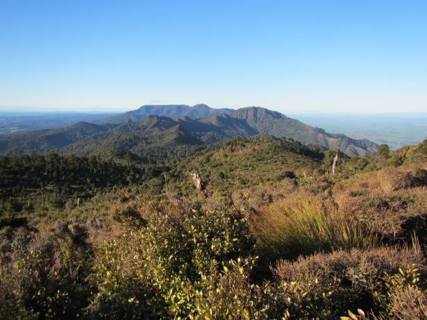
3 1 Background The Kaimai Range is a band of hills providing a dramatic boundary between the Waikato and the northern Bay Of Plenty. The Range provides the spine of the northern section of the Kaimai Mamaku Conservation Park. Conservation Parks are public lands managed by the Department of Conservation (DOC) so that their natural and historic resources are protected and public access and enjoyment facilitated. The Park is of significant historical interest (especially kauri extraction and various mining ventures), and has high ecological values, including varied forest types, a wide variety of vegetation and open ridgetop environments. There is a major amount of rugged bush and ridgetop spaces which are mostly beyond the reach of the casual day walker. But they have the potential to provide an ideal outdoor experience for capable and fit trampers and hunters. The Park lies within 2 hours driving for over half of New Zealand s population, and also a key New Zealand gateway for all the overseas visitors that are attracted by the many special outdoor experiences that our country provides. The backcountry potential of the Kaimai Range is not being realised because of scarce development resources within the DOC annual funding allocations, so the existing backcountry facilities of tracks and huts are patchy, suffering from : Insufficient huts location, size, facilities Intermittently maintained tracks Boggy tracks requiring surface protection Areas of special interest with downgraded access, rather than having suitable facilities to allow visitors to appreciate their significance. In 2014 the Kaimai Concept Plan was presented to DOC and the Outdoor Recreation Consortium to support successful applications for volunteer led funding aimed at : Development of the Kaimai Ridgeway - providing a new multi day trail incorporating spectacular ridgetop tracks that were becoming derelict Volunteer managed track maintenance for tramping tracks The construction of additional huts to provide comfortable shelter for multi day trips During 2015 there have been some significant outcomes from the resulting work, but to fully realise the objectives of the Kaimai Concept Plan, it has now evolved into this Kaimai Backcountry Management Plan, presenting a more comprehensive plan for the complete Kaimai backcountry experience. At the start of 2016, the Kaimai Ridgeway Trust was formed to take over ownership of the plan and provide the management structure required to sustain the Kaimai Project over a long period of time. Version 2.4 Page 3 of 27 2 nd June, 2016
4 2 Objectives To provide well maintained tracks, huts and campsites throughout the Kaimai Range in order to : provide a wide range of options for enjoyable and achievable day and multi day backcountry activities; and provide comfortable places to stay for people undertaking multi day activities; and provide an improved track and hut network that reduces the opportunities for getting lost, or being delayed unexpectedly overnight without suitable shelter; and provide facilities that support increased visitor numbers without causing environmental degradation provide facilities that allow visitors to sensitively appreciate areas of ecological interest; and provide facilities for track maintenance work parties in remote areas; and provide facilities that support pest control activities; and provide facilities that encourage young people to enjoy and appreciate backcountry activities; and provide access to publicly owned conservation land; and 3 Outcomes Primary outcomes achievable from execution of this plan are : A significant increase in numbers of people engaging in backcountry activities in the Kaimai Range A named trail the Kaimai Ridgeway that attracts visitors from throughout New Zealand and from overseas, and leads to them recommending it to their friends An enduring relationship with tangata whenua to advance mutual aspirations for the Kaimai Range A wider appreciation and enjoyment of all that is special in the Kaimai Range Facilities to support greater conservation protection throughout the Range The realisation of ownership of these outcomes by all participants Financial benefits to the surrounding regions from increased visitor numbers 4 Policies In execution of this plan the following policies are being applied : Long term sustainability of maintenance and development activities Volunteer work parties apply best practice health and safety measures New facilities are available for public use and enjoyment New huts are constructed using fireproof materials KRT ownership of new facilities created under this plan Support for all outdoor groups operating in the Kaimai range 5 The Kaimai Ridgeway Trust Version 2.4 Page 4 of 27 2 nd June, 2016
5 The Kaimai Ridgeway Trust (KRT) is an association of Kaimai Range interested groups, including tramping clubs from the Bay Of Plenty, the Waikato, and Auckland, and Deerstalkers branches from the Bay Of Plenty, Thames Valley, Hamilton and Auckland. This has evolved from an Auckland Tramping Club (ATC) led association into an independent organisation focused solely on the achievement of this plan. 6 KRT Management Structure The KRT consists of : A management committee that represents the major supporting clubs An affiliation from all supporting groups and interested individuals The role of the trust is to provide overall direction, prioritisation, co-ordination, and funding, with this being sustainable over a long period of time. Affiliated clubs take responsibility for execution of specific facilities within the Plan, be that the maintenance of a section of tracks, maintenance of hut(s), or a combination of the two. Multiple funding sources will be accessed, to ensure progress can be made quickly once Plans are established. The trustees are Roger Montgomerie Kaimai Ramblers Chairman Maureen Coleman Thames Valley Deerstalkers John Harris Independent Health & Safety Stan Lowe Bay Of Plenty Deerstalkers Huts Tony Walton Auckland Tramping Club Secretary, Treasurer Other Key Roles John McArthur Waikato Tramping Club Tracks 7 Kaimai Ridgeway Trust - DOC Partnership An essential component of this plan is the partnership between the KRT and DOC. While the KRT can provide focused work in execution of the plan, it can only succeed via a close working relationship with DOC that acknowledges all the values and objectives that makes DOC such a special organisation for our country. There are some differing priorities, but with constant dialogue and listening to each other, these differences are resolvable, allowing achievement of mutually desired outcomes that each organisation cannot achieve on its own. Version 2.4 Page 5 of 27 2 nd June, 2016
6 8 Affiliated Organisations The following organisations are affiliated with the KRT : Auckland Deerstalkers Auckland Baptist Tramping Club Auckland Tramping Club Bay Of Plenty Deerstalkers Cambridge Tramping Club Individuals Kaimai Ramblers Katikati Tramping Club Manukau Tramping Club North Auckland Deerstalkers North Shore Tramping Club Tauranga Mid Week Tramping Group Thames Valley Deerstalkers Waikato Deerstalkers Waikato Tramping Club Whakamarama Community 9 Structure of the The remainder of this document elaborates the targets of the plan via : Description of the Kaimai Ridgeway route and facilities Detailing all the Kaimai Range backcountry facilities o Definition of geographical zones of the Kaimai Range, with maps, to assist in understanding of the detail o Detailing the current and planned Kaimai facilities by zone, including targets for the KRT o Detailing Kaimai facilities that are not in scope for potential inclusion in KRT activity Providing suggestions for day, overnight, and multi day hike options that this Plan will assist to deliver Version 2.4 Page 6 of 27 2 nd June, 2016
7 10 High Priority Objective the Kaimai Ridgeway The Kaimai Ridgeway will deliver a significantly improved Kaimai backcountry experience leading to : Increased visitor numbers from New Zealand and overseas for multi day trips Improved access and facilities for hunters Improved access and facilities for conservation work Increased visitor numbers and supporting services in the towns surrounding the Kaimai Range A major local community involvement, sense of ownership and pride in their local Park 10.1 New Huts The achievement of this requires 4 new huts, spaced suitably to support a day s hike for a person of medium fitness. In summary : Zone Temporary Hut Name Purpose Priority South Ngamuwahine Hut Kaimai Ridgeway Night 1, hunting, track 1 (High) maintenance Wairere Kaimai Hut Kaimai Ridgeway Night 2, hunting, track 2 (High) maintenance Central Thompsons Hut Kaimai Ridgeway Night 3, hunting, track 3 (Med) maintenance North Ridgeway Hut Kaimai Ridgeway Night 5, hunting, track maintenance 4 (Med) Location details are provided later in this plan. Temporary hut names are highlighted in this plan by including the name in double quotes. These will all be of the same design, providing : 12 bunks, in a 2 level bunk platform style Water tank and outdoor sink Logburner with firewood provided Toilet Camping spaces near the hut Fireproof materials These huts will be funded and owned by the KRT, but made available for public access as per other huts in the DOC hut network. In the spirit of recognising backcountry eventualities, with the ability to allow parties to adapt to changing weather conditions or individual needs, hut bookings will only be mandatory for large groups. This policy will be applied to all huts in the Park, excluding Waitawheta Hut. The following is a description of the planned Kaimai Ridgeway route and facilities for the, travelling from South to North. Version 2.4 Page 7 of 27 2 nd June, 2016
 Hut priority Number 1 SH29 to Hurunui Hut 3 hours Hurunui Hut to Ngamuwahine Hut 3 hours 10.")
 Wairere Junction Wairere Falls (top) Wairere Track Optional side Wairere Junction Kaimai Hut Kaimai Ridgeway (previously North")
8 10.2 Day 1 Kaimai Summit to Ngamuwahine Hut Zone Start End Via Notes South Kaimai Ridgeway Ngamuwahine Hut SH29 end Kaimai Ridgeway (previously North South Track) Hut priority Number 1 SH29 to Hurunui Hut 3 hours Hurunui Hut to Ngamuwahine Hut 3 hours 10.3 Day 2 Ngamuwahine Hut to Kaimai Hut Zone Start End Via Notes South Ngamuwahine Hut Wairere Track / Kaimai Ridgeway Northern Junction Kaimai Ridgeway (previously North South Track) Wairere Junction Wairere Falls (top) Wairere Track Optional side Wairere Junction Kaimai Hut Kaimai Ridgeway (previously North South Track) trip Hut Priority Number 2 Version 2.4 Page 8 of 27 2 nd June, 2016


9 Ngamuwahine Hut to Wairere 3 hours Wairere to Kaimai Hut 2 hours 10.4 Day 3 Kaimai Hut to Thompsons Hut Zone Wairere Start Kaimai Hut End Thompsons Hut Via Kaimai Ridgeway (previously North South Track) Notes Hut Priority Number 3 Kaimai Hut to Thompsons Hut 5 hours Version 2.4 Page 9 of 27 2nd June, 2016

 Te Rereatukahia Hut Track / Wharawhara Tramway / Upper Waitawheta Tracks Option 2 less favourable weather The Kaimai Ridgeway, once")
10 10.5 Day 4 Thompsons Hut to Te Rereatukahia Hut Zone Start End Via Notes Central Thompsons Hut Te Rereatukahia Hut Kaimai Ridgeway (previously North South Track) Thompsons Hut to Motutapere Hut Motutapere Hut to Te Rereatukahia Hut 3 hours 3 hours 10.6 Day 5 Te Rereatukahia Hut to Ridgeway Hut or Waitawheta Hut Zone Start End Via Notes Central / Te Rereatukahia Ridgeway Hut Kaimai Ridgeway Option 1 North Hut (previously Old good weather Central / North Te Rereatukahia Hut Waitawheta Hut North South Track) Te Rereatukahia Hut Track / Wharawhara Tramway / Upper Waitawheta Tracks Option 2 less favourable weather The Kaimai Ridgeway, once suitably maintained again, will still not be a fast route, involving as it does a traverse of Baldy, a significant sidle of Tangitu, and then ongoing ridge travel through ridgetop areas, bush, saddles, and multiple high points and places to stop to enjoy the views. The possible locations for the Ridgeway Hut require detailed investigation, but in general these will provide a suitable day s tramping from both Te Rereatukahia and Dalys Clearing Huts, and will also focus trampers and hunters to use the hut facilities, rather than camping freely in an area where the environment needs sensitive appreciation. It is also a desirable area for work parties to have as their overnight destination as it requires a minimum of 2.5 hours fit tramping from the nearest road end. Version 2.4 Page 10 of 27 2 nd June, 2016


11 Option 1 Kaimai Ridgeway Option 2 Waitawheta Hut Te Rereatukahia Hut to Ridgeway Hut Te Rereatukahia Hut to Waitawheta Hut - 5 to 6 hours 6 to 7 hours Version 2.4 Page 11 of 27 2 nd June, 2016
 Option 2 Two options")

12 10.7 Day 6 Ridgeway Hut or Waitawheta Hut to Dalys Clearing Hut Zone Start End Via Notes North Ridgeway Hut Dalys Clearing Hut Kaimai Ridgeway, Option 1 Waipapa Track, Mangakino Pack Track, Dalys Clearing Track North Waitawheta Hut Dalys Clearing Hut Waitawheta Stream, Dalys Clearing (with optional side trips) Option 2 Two options dependent on the choice taken the previous day. In addition, a faster party that started at Waitawheta Hut could reach Karangahake Gorge in a longer day. Option 1 Kaimai Ridgeway Option 2 Waitawheta Hut Ridgeway Hut to Dalys Clearing Hut Waitawheta Hut to Dalys Clearing Hut - 7 hours 2.5 to 3 hours Version 2.4 Page 12 of 27 2 nd June, 2016

13 10.8 Day 7 Dalys Clearing Hut to Karangahake Gorge Zone Start End Via Notes North Dalys Clearing Mangakino Pack Dalys Clearing Hut Track at the Track, Mangakino North North Mangakino Pack Track at the Waitawheta River Mangakino Pack Track at the Waitawheta River Waitawheta River Pack Track Karangahake Gorge Dickeys Flat, Waitawheta Pipeline Walk Karangahake Gorge Mangakino Stream Track, Dubbo 96 to Mt Karangahake, then down to Karangahake Gorge Option hours Option hours Version 2.4 Page 13 of 27 2 nd June, 2016

14 11 The Kaimai Range 11.1 Zone Definition The lines drawn on these maps are zone boundaries, not tracks Zone Definition Targets North From Karangahake Gorge south West of the Waitawheta Hut Southern boundary at a line drawn from Waitawheta Hut to the junction of the Mangakino Pack Track and the side track to the Tui Mine site Some tracks to and from Mt Karangahake are now under KRT maintenance. Other tramping tracks are potential KRT maintenance. Dalys Clearing hut being maintained by Manukau TC Version 2.4 Page 14 of 27 2 nd June, 2016


15 Zone Definition Targets North East East of the Waitawheta River From Waitawheta hut to the junction with the Wairoa Shelter Track, and the tracks East from that junction Some tracks are already In the KRT maintenance schedule Other tracks to be added to KRT maintenance as resources permit Zone Definition Targets Waiorongomai Areas around Mt Te Aroha and the tracks to the West of Waiorongomai Stream Waipapa Track through to Waitawheta Hut Principally an area of DOC maintenance because of higher standard and use Version 2.4 Page 15 of 27 2 nd June, 2016

16 Zone Definition Targets Central South of Waipapa Track East of Waiorongomai Stream All tracks and huts south to Thompsons track saddle Kaimai Ridgeway route from Waipapa south along the Old NS track Te Rereatukahia Hut improvements done by the KRT have made it a pleasanter place to stay A significant proportion of the tracks are already Motutapere Hut maintenance by TV Deerstalkers is now managed under the KRT agreement Most tracks in this zone are already In the KRT maintenance schedule Version 2.4 Page 16 of 27 2 nd June, 2016

17 Zone Definition Targets Wairere South from Thompsons Track Saddle to Wairere Track New standard Kaimai 12 bunk hut E of Thompsons saddle New standard Kaimai 12 bunk hut SW of Aongatete Lodge Kauritatahi Hut maintenance by TV Deerstalkers is now managed under the KRT agreement Rename the North South Track to Kaimai Ridgeway, extending the named route south from the Central zone KRT maintenance commencing during 2016 Medium term evaluation of reintroducing the tramping route along Te Hanga Ridge, in consultation with landowner on the western side of the ridge, having regard to the measures required to protect this ecologically interesting area Version 2.4 Page 17 of 27 2 nd June, 2016

18 Zone Definition Targets South All tracks S of the Wairere Track to SH29 New standard Kaimai 12 bunk hut at the site of the old Ngamuwahine shelter Most tracks are already In the KRT maintenance schedule Mangamuka Hut maintenance by BOP Deerstalkers is now managed under the KRT agreement Hurunui Hut maintenance by BOP Deerstalkers is now managed under the KRT agreement Version 2.4 Page 18 of 27 2 nd June, 2016
19 11.2 Kaimai Backcountry Features These are included as in scope for this plan. Zone Feature Targets North Tracks to / from Mt Karangahake, Dubbo 96 Track KRT maintenance (Auckland Baptist TC) All other tramping tracks around Mt Karangahake, excluding Waitawheta Pipeline Potential KRT maintenance once tracks further south are being managed well Mangakino Stream Track Medium priority KRT maintenance addition Dickeys Flat to Mangakino Potential KRT maintenance Stream Track junction Mangakino Pack Track S to junction with side track to Tui Mine site KRT maintenance (Manukau TC / Auckland TC ) Dean Track KRT maintenance (Manukau TC) Dalys Clearing Track KRT maintenance (Manukau TC) Dalys Clearing Hut KRT maintenance (Manukau TC) Night 6 in the south to north Kaimai Ridgeway North East Bluff Stream Track and Bluff Stream Kauri Grove track To be added to KRT maintenance as resources permit Waitengaue Track To be added to KRT maintenance as resources permit Wairoa Stream Track To be added to KRT maintenance as resources permit Lindemanns Loop Track (Katikati TC) Wairoa Shelter Track (Katikati TC) Upper Waitawheta Track to Wairoa Shelter Track junction To be added to KRT maintenance as resources permit Waiorongomai Mangakino Pack Track from Tui KRT maintenance (Auckland TC) Mine side track to Waipapa Track Tui mine site area Potential KRT maintenance low priority Tracks to the W of Waiorongomai Stream KRT to monitor maintenance state, but not expecting to be added into KRT maintenance Central Pylon Peak Track KRT maintenance (Auckland TC) Kaimai Ridgeway (renamed from Old North South) through to Pylon Peak junction (Auckland TC) High priority to work with DOC to Kaimai Ridgeway (renamed from Old North South) from Pylon Peak junction to Te implement track stabilisation (Auckland TC / Waikato TC) A high priority to finish clearing (60- Version 2.4 Page 19 of 27 2 nd June, 2016
20 Zone Feature Targets Rereatukahia hut 70% done) and stabilise the surface New hut - Ridgeway Hut Assess options for a hut site for a standard Kaimai 12 bunk hut in the general vicinity from Pahiko S on the north side of the ridge a few options requiring investigation Hut priority (medium) after the 3 new huts further south Cashmores Clearing Track Upper Waitawheta Track / Wairoa Shelter Track junction down Wharawhara Tramway Track to the junction with Wharawhara Loop Track Wharawhara Link Track to Wharawhara Rd Te Rereatukahia Hut Track to Wharawhara Link Track junction Te Rereatukahia Hut Central Te Rereatukahia Hut Track / Wharawhara Link Track junction to Hot Springs Rd (Also known as Kauri Grove Track) North South Track from Te Rereatukahia Hut to Thompsons Track saddle Tuahu Track Sentinel Rock Track Will be an important base for through walkers, hunters, and work parties. Good weather option for night 5 in the south to north Kaimai Ridgeway Medium to longer term priority to assess work required to make this track usable again, taking note of the areas that require special protection To be added to KRT maintenance as resources permit (Waikato TC) May remove this from KRT maintenance in (Waikato TC) Major improvements made by KRT during Continue maintenance. On the full south to north Kaimai Ridgeway, this now provides a comfortable backcountry overnight stop for night 4. DOC to determine and implement kauri protection measures To then be added to KRT maintenance as resources permit Rename to Kaimai Ridgeway Continue track remediation (metalling, etc) (Waikato TC) (Kaimai Ramblers) (Kaimai Ramblers) Version 2.4 Page 20 of 27 2 nd June, 2016
21 Zone Feature Targets Mt Eliza Track To be added to KRT maintenance as resources permit Motutapere Hut Thames Valley Deerstalkers maintenance continues under the KRT agreement Wairere New hut Thompsons Hut A hut location to the south of Thompsons track far away enough to avoid any historic problems of people coming in from Thompsons track 4x4 Track. The suggestion is an existing small clearing at or about GR The location is just off the new N/S track and N/E about 150 Meters East on a ridge track that comes up from the East end of Thompsons Track Road (not a DOC track) The location offers a sunny warm spot, sheltered, with nice views to the north and west Standard Kaimai 12 bunk hut Hut priority (medium) after the 2 new huts further south Wairere Kauritatahi Hut Track Kauritatahi Hut North South Track from Thompsons Track saddle to Wairere Track Poupou track from Upland Rd to Kaimai Ridgeway Track from Wright Rd to Kaimai Ridgeway New hut Kaimai Hut On the full south to north Kaimai Ridgeway, this will provide a comfortable backcountry overnight stop for night 3. (Auckland TC) Maintain to a basic route standard Assessment of remedial track protection measures required Thames Valley Deerstalkers maintenance continues under the KRT agreement KRT maintenance addition Auckland North Shore TC assessing for maintenance responsibility To be added to KRT maintenance as resources permit Section not maintained by Aongatete Lodge to be added to KRT maintenance as resources permit About GR (about 1 hour south of the Aongatete river crossing) being an ideal spot set at about 400 metres above sea level, sheltered for the South and East on what would be described as an inner Version 2.4 Page 21 of 27 2 nd June, 2016
22 Zone Feature Targets ridge with views to the north and great views west to the face and top of Te Hanga Ridge / Ngatamahinerua Tops. This location is on dry ground with minimal tree clearing required and has the plus of cell phone coverage. Standard Kaimai 12 bunk hut Hut priority (high) after the new Ngamuwahine Hut On the full south to north Kaimai Ridgeway, this will provide a comfortable backcountry overnight stop for the second night. Te Hanga Ridge Track This is also located in an area of significant interest to deerstalking groups. Originally part of the North South Track this was closed for ecological protection, including to protect the ridge from significant damage because of areas that can become very boggy Wairere Wairere Track from the top of the Falls eastwards to where the North South Track turns southwards This is still accessed by hardy trampers and hunters, with a multitude of marking tapes and some old markers. With an appropriately designed and maintained track this would become a memorable fine weather addition to the Kaimai Ridgeway route options, and an interesting route for those keen to appreciate its ecological values. From the top of the ridge westwards is a Maori owned landblock Maurihoro B consultation required as part of future plans It is a medium term priority to commence assessment of the options for reopening this route KRT maintenance (Auckland TC) Version 2.4 Page 22 of 27 2 nd June, 2016
23 Zone Feature Targets Wairere Track east from where the North South Track turns southwards To be added to KRT maintenance as resources permit Including determining where it officially exits / leaves Conservation land on the South South North South Track from Wairere Track to Te Tuhi Track junction Te Tuhi Track, ending at the North South junction Ngamarama Track North South Track from Te Tuhi Track to Leyland O Brien Track junction Mangamuka Hut Tracks from Te Tuhi Track to the Mangamuka Hut and on to the North South Track Mangamuka Hut New hut Ngamuwahine Hut Leyland O Brien Track from Whakamarama Rd to Ngamuwahine Track junction Ngamuwahine and Ngamuwahine Loop (Bob s) Tracks Leyland O Brien Track from Ngamuwahine Track junction to North South junction North South Track from Leyland O Brien track junction to SH29 Hurunui Hut eastern side Rename to the Kaimai Ridgeway (Cambridge TC) (Cambridge TC) (Auckland TC) Rename to the Kaimai Ridgeway (Auckland TC) To be added to KRT maintenance as resources permit Monitoring by BOP Deerstalkers BOP Deerstalkers maintenance continues under the KRT agreement New standard Kaimai 12 bunk hut at the site of the old Ngamuwahine shelter Highest hut priority detailed design and costing work completed awaiting consultation processes to occur before it can proceed On the full south to north Kaimai Ridgeway, this will provide a comfortable backcountry overnight stop for the first night. This hut is also located in an area that is popular with the deerstalking groups (Tauranga Mid Week Tramping Group - TMWTG) (TMWTG) (TMWTG) Rename to the Kaimai Ridgeway (TMWTG) BOP Deerstalkers maintenance continues under the KRT agreement Version 2.4 Page 23 of 27 2 nd June, 2016
24 Zone Feature Targets Henderson Tramway Tracks (North and West) (TMWTG) Kaimai Summit Track (TMWTG) All Toilets at track ends The Kaimai Range has 26 main public access points from roads around the boundaries of the Park. Not all of these have toilets or suitable carparking. Work with local authorities for the establishment and maintenance of toilets at the Kaimai public access points that do not already have a toilet, and ensure that carpark facilities are suitable for increasing visitor numbers. Version 2.4 Page 24 of 27 2 nd June, 2016
25 11.3 Other Features These are not included in this plan, principally because they are easily accessible to a wide range of visitor types, and consequently already require and receive a significant amount of DOC maintenance and development resources. Zone Feature Notes North Waitawheta Pipeline Track Waitawheta Valley Track from Franklin Rd to Waitawheta hut Waiorongomai Waitawheta Hut Waipapa Track Mt Te Aroha Track Tracks in the Waiorongomai Valley to the west of the Waiorongomai Stream Monitoring to assess any KRT support applicable Waiorongomai Kauri Grove Track To be closed for kauri protection purposes Central Thompsons Track Not a DOC managed track Wairere Tracks maintained by Aongatete Lodge Wairere Track from western carpark to the junction near the top of the Wairere Falls Old alternative side track on the western ascent to the Wairere Falls All All access tracks that are not on Conservation land Version 2.4 Page 25 of 27 2 nd June, 2016
26 12 Future Kaimai Hiking Options This section suggests a number of day, overnight, and multi day hiking options in the Kaimai Range that the increased focus on providing suitable backcountry facilities will support. In the following Blue type with one asterisk indicates all tracks are now being maintained by the KRT groups in association with DOC eg Existing * And Purple type with 2 asterisks indicates some of the tracks involved are now being maintained by the KRT groups in association with DOC eg Existing ** 12.1 Day Hike Options Some existing and planned single day hikes in the Park : Zone Route Grade Status North Waitawheta River from Karangahake Easy Existing Gorge North Mt Karangahake Waitawheta River Medium - Easy Existing ** circuit North Franklin Rd end circuit incorporating Medium Existing ** Dalys Clearing hut North East Waitengaue / Ananui Medium Existing North East Lindemann Loop / Wairoa Shelter Medium - Easy Existing * Waiorongomai Wairongomai Pack tracks Easy Existing Central Waiorongomai Kaimai Ridgeway Waipapa Waiorongomai Pack loop Medium - Hard Now open ** more work needed Wairere Thompsons Track E or W to / from Kauritatahi Hut / DC3 crash site Medium Existing ** - Thompsons Track is a mess Wairere Aongatete Lodge area tracks Easy Existing Wairere Wairere Falls / return Easy Existing Wairere / Wairere Falls / Te Tuhi Medium - Hard Existing ** South South Te Tuhi / Mangamuka Hut / NS loop Medium Existing ** South Henderson Tramway tracks / NS Easy Existing * 12.2 Overnight Hike Options Some existing and planned overnight hikes in the Park : Zone Route Grade Status North Franklin Rd to / from Waitawheta hut Easy Existing North Franklin Rd to / from Dalys Clearing hut Easy Existing ** North East Woodland Rd or Lindermann Rd to / from Waitawheta hut Medium Existing ** Waiorongomai Wairongomai valley to / from new Ridgeway Medium Planned * Hut Waiorongomai Wairongomai valley to / from Waitawheta Hut Medium Existing ** Version 2.4 Page 26 of 27 2 nd June, 2016
27 Zone Route Grade Status via existing tracks or incorporating the Pylon Peak Track Waiorongomai / Central Central Central Central / Wairere Waiorongomai Valley Pylon Peak Kaimai Ridgeway - Te Rereatukahia Hut Kaimai Ridgeway Tuahu West Loop involving Te Rereatukahia Hut Kaimai Ridgeway Tuahu E etc from either Wharawhara or Hot Springs Rd A number of road ends to / from Motutapere Hut Thompsons Track E or W to / from Kauritatahi Hut Hard Existing * / Maintenance continuing Medium Existing * Medium Existing ** Medium Existing **- Thompsons Track is a mess Medium Planned ** Wairere Poupou / Aongatete access points Kaimai Ridgeway to / from new Thompsons Hut Wairere Poupou / Aongatete / Wairere Falls access Medium Planned ** points Kaimai Ridgeway to / from new Kaimai Hut South Te Tuhi to / from Mangamuka Hut Medium Existing ** South Te Tuhi / Whakamarama / Ngamuwahine Rd / Medium Planned * Henderson Tracks / Kaimai Ridgeway to / from new Ngamuwahine Hut South Various road ends to / from Hurunui hut Easy Existing * 12.3 Multi Day Hike Options Some existing and planned multi day hikes in the Park : Zone Route Grade Status All Kaimai Ridgeway via SH29 Hurunui hut Ngamuwahine Hut Kaimai Hut Thompsons Hut Te Rereatukahia Hut Wharawhara Waitawheta Hut Mangakino track Dickeys Flat Karangahake Gorge 7 days (Medium) 5 days (Hard) All Wairere / Central / North Kaimai Ridgeway via SH29 Hurunui hut Ngamuwahine Hut Kaimai Hut Te Hanga Ridge Kauritatahi Hut / Thompsons Hut Te Rereatukahia Hut Kaimai Ridgeway Ridgeway Hut Dickeys Flat Karangahake Gorge OR Mt Karangahake Kaimai Ridgeway via Wairere Falls Thompsons Hut Te Rereatukahia Hut Kaimai Ridgeway Ridgeway Hut Mt Karangahake Karangahake Gorge 7 days (Medium) 5 days (Hard) Medium Hard 4 Days All Other Variations supporting 3+ day trips Medium - Hard Existing / Planned Existing / Planned / Investigate Planned Existing / Planned / Investigate Version 2.4 Page 27 of 27 2 nd June, 2016
Kaimai Backcountry Management Plan
 Kaimai Backcountry Management Plan Kaimai Community Version 2.0 19 th September, 2015 Contents 1 Background... 3 2 Objectives... 4 3 Outcomes... 4 4 The Kaimai Community... 4 5 Kaimai Community - DOC Partnership...
Kaimai Backcountry Management Plan
 Kaimai Backcountry Management Plan Kaimai Community Version 2.2 11 th November, 2015 Contents 1 Background... 3 2 Objectives... 4 3 Outcomes... 4 4 The Kaimai Community... 4 5 Kaimai Community - DOC Partnership...
The Kaimais Concept. Improving Outdoor Recreational Opportunities in Kaimai Mamaku Conservation Park From Backwater to Stomping Ground
 The Improving Outdoor Recreational Opportunities in Kaimai Mamaku Conservation Park From Backwater to Stomping Ground Background The Kaimai range is a band of hills providing a dramatic boundary between
Kaimai Concept. The Kaimai Concept. Improving Outdoor Recreational Opportunities in Kaimai Mamaku Conservation Park From Backwater to Stomping Ground
 The Kaimai Concept Improving Outdoor Recreational Opportunities in Kaimai Mamaku Conservation Park From Backwater to Stomping Ground Background The Kaimai range is a band of hills providing a dramatic
Kaimai to coast. Walks and tramps. Activity planner KAIMAI-MAMAKU FOREST PARK AND SURROUNDING AREAS. Southern Kaimai and Mamaku Plateau 33
 Kaimai to coast Walks and tramps KAIMAI-MAMAKU FOREST PARK AND SURROUNDING AREAS Key to symbols is on pages 11 and 12. Activity planner Page Karangahake Gorge 13 Waitawheta Valley 17 Te Aroha and Waiorongomai
Submission on the Tukituki Catchment Proposal: EPA reference numbers; NSP 13/ , NSP 13/ , NSP 13/ , NSP 13/02.
 Hutt Valley Tramping Club PO Box 30 883 LOWER HUTT 5045 Tukituki Catchment Proposal Environmental Protection Agency Private Bag 63 002 WELLINGTON 6140 29 July 2013 Submission on the Tukituki Catchment
KKTC Club Trip Attendance & Leaders
 KKTC Club Trip Attendance & Leaders 2017-1977 Incomplete records for some years are due due to missing reports and trip books Date Venue No Leader 2017 1/01/2007 Waitawheta to log bogie and Dalys Hut loop
A summary of Draft Makara Peak Mountain Bike Park Master Plan
 A summary of Draft Makara Peak Mountain Bike Park Master Plan OVEMBER 216 Image: Peter Marshall 2 3 Introduction Since it was established in 1998, the Makara Peak Mountain Bike Park (Makara Peak) has grown
Land Management Summary
 photo credit: ANGAIR Anglesea Heath Land Management Summary The Anglesea Heath (6,501 ha) was incorporated into the Great Otway National Park in January 2018. This provides an opportunity to consider the
RE: Access Fund Comments on Yosemite National Park Wilderness Stewardship Plan, Preliminary Ideas and Concepts
 September 30, 2016 Superintendent Yosemite National Park Attn: Wilderness Stewardship Plan P.O. Box 577 Yosemite, CA 95389 RE: Access Fund Comments on Yosemite National Park Wilderness Stewardship Plan,
The Strategic Commercial and Procurement Manager
 Item 3 To: Procurement Sub Committee On: 8 June 2016 Report by: The Strategic Commercial and Procurement Manager Heading: Renfrewshire Council s Community Benefit Strategy 2016 1. Summary 1.1. The purpose
Park-specific management and policies Wainuiomata Recreation Area
 Park-specific management and policies Wainuiomata Recreation Area 6.8 Wainuiomata Recreation Area 6.8.1 Legal status Title held: Legislative status: Wellington Regional Council Administered under Local
Preferred Recreation Recommendations Stemilt-Squilchuck Recreation Plan March 2018
 Preferred Recreation Recommendations Stemilt-Squilchuck Recreation Plan March 2018 Below are the recommended recreation ideas and strategies that package together the various recreation concepts compiled
Quick Start Track 1: Hokianga to Opua/Russell
 Quick Start Track 1: Hokianga to Opua/Russell Kaikohe to Okaihau section PROJECT DESCRIPTION The overall opportunity is to develop a 90-kilometre trail from the Hokianga Harbour on the West coast through
Karaka Mountain Bike Track Bridge Structures
 Memo Information 1 Karaka Mountain Bike Track Bridge Structures TO FROM Infrastructure Committee Greg Hampton - Area Manager, Thames & Coromandel DATE 4 November 2015 SUBJECT Karaka Mountain Bike Track
Waikato Plan. A SUMMARY Building champion communities, together. August 2017
 Waikato Plan A SUMMARY Building champion communities, together August 2017 The mighty Waikato region is a place of powerful possibilities. Forged by a proud history and shared excitement about the future,
First proposed route Purangi Estuary to Hot Water Beach. Stella Evered Reserve. Purangi Estuary
 Great Walks Project First proposed route Purangi Estuary to Hot Water Beach PACIFIC OCEAN Cathedral Cove Hahei Hereheretaura Ngati Hei Pa site Stella Evered Reserve Proposed Carpark Lees Rd Blow Hole site
Illawarra Escarpment State Conservation Area Walking Tracks
 Illawarra Escarpment State Conservation Area Walking Tracks NPWS Illawarra Area Office Ground Floor, Government Office Block 84 Crown Street Wollongong NSW 2500 02 4223 3000 (Mon-Fri) Royal National Park
Discover... Sledge. Track. Essence of Aotearoa. You ll find there s much more than meets the eye!
 Sledge Discover... Track Essence of Aotearoa You ll find there s much more than meets the eye! Discover... Manawatu s timeless walkway adventure. Lying in the heart of the scenic Kahuterawa Valley, Sledge
Around and about Geraldine
 Around and about Geraldine A guide to recreational opportunities SOUTH CANTERBURY Track classifications Short walk Easy walking for up to an hour Track is well formed, with an even, welldrained surface.
Council Controlled Organisations
 155 annual report 2013 / 2014 Council Controlled Organisations Council Controlled Organisations and Council Organisations provide opportunities for councils to provide services and activities. A Council
Calderdale MBC. Wards Affected: Town. Economy and Investment Panel: 20 October Halifax Station Gateway Masterplan
 Calderdale MBC Wards Affected: Town Economy and Investment Panel: 20 October 2016 Halifax Station Gateway Masterplan Report of the Acting Director, Economy and Environment 1. Purpose of the Report 1.1
$244 $45 OVERVIEW National Land Transport Programme Bay of Plenty BAY OF PLENTY REGIONAL SUMMARY
 2015 18 National Land Transport Programme Bay of Plenty BAY OF PLENTY REGIONAL SUMMARY OVERVIEW Transport investment in the Bay of Plenty is targeted to support significant residential growth, new industrial
Draft Marine and Harbour Facilities Strategy
 Draft Marine and Harbour Facilities Strategy Vision The Coromandel peninsula is a destination of choice for safe, sustainable and accessible marine and harbour facilities that are fit for purpose to meet
Waikato Regional Economic Development Strategy
 Waikato Regional Economic Development Strategy 1 TO FROM Economic Development Committee Ben Dunbar-Smith - Economic Development Programme Manager DATE 6 April 2016 SUBJECT Waikato Regional Economic Development
Te Kowhai COMMUNITY PLAN
 1 2011-2021 Te Kowhai COMMUNITY PLAN Vision To realise a lifestyle potential 2 Map of Te Kowhai area 3 4 History of the plan In 2004 the Te Kowhai Community Group Committee and the residents put together
Discover. Sledge Track Essence of Aotearoa
 Discover Sledge Track Essence of Aotearoa Discover Manawatu s timeless walkway adventure. Lying in the heart of the scenic Kahuterawa Valley, Sledge Track brings you face to face with the majesty of New
Final Environmental Impact Statement for the Merced Wild and Scenic River. Comprehensive Management Plan, Yosemite National Park, Madera and Mariposa
 This document is scheduled to be published in the Federal Register on 02/26/2014 and available online at http://federalregister.gov/a/2014-04061, and on FDsys.gov DEPARTMENT OF THE INTERIOR 4312-FF NATIONAL
Regional Economic Development Under-Secretary Fletcher Tabuteau
 EMBARGOED UNTIL 2.30 PM Regional Economic Development Under-Secretary Fletcher Tabuteau Speech to Waikato regional economic development stakeholders meeting hosted by Waikato Regional Economic Development
Regional Transport Committee OPEN MINUTES
 Regional Transport Committee OPEN MINUTES Minutes of a meeting of the Regional Transport Committee held in Council Chambers, Waikato Regional Council, 401 Grey Street, Hamilton East on 11 June 2018 at
Accommodation Survey: November 2009
 Embargoed until 10:45am 19 January 2010 Accommodation Survey: November 2009 Highlights Compared with November 2008: International guest nights were up 2 percent, while domestic guest nights were down 1
Continental Divide National Scenic Trail Legislative History and Planning Guidance
 Continental Divide National Scenic Trail Legislative History and Planning Guidance Legislation, Policy, and Direction Regarding National Scenic Trails The National Trails System Act, P.L. 90-543, was passed
Auckland Port and the Unitary Plan Dr Douglas Fairgray
 Auckland Port and the Unitary Plan Dr Douglas Fairgray Source: Auckland 1886 - Sir George Grey Special Collections, Auckland Libraries, NZ Map 374 Scope The interface between the Unitary Plan and the Port
Draft Strategic Plans for Coillte s eight Business Area Units ( )
") Draft Strategic Plans for Coillte s eight Business Area Units (2011-2015) Response to Public Consultation from Mountaineering Ireland April 2013 1 Introduction Mountaineering Ireland welcomes this opportunity
Draft Strategic Plans for Coillte s eight Business Area Units (2011-2015) Response to Public Consultation from Mountaineering Ireland April 2013 1 Introduction Mountaineering Ireland welcomes this opportunity
The Aotea Track offers a range of spectacular landscapes, superb views and rich history.
 Aotea Track Located in Great Barrier Island/Aotea in the Auckland region The Aotea Track offers a range of spectacular landscapes, superb views and rich history. Travel over streams that show off a constant
Sibley LUPA. Board Executive Committee Meeting December 7, 2017
 Sibley LUPA Board Executive Committee Meeting December 7, 2017 Project Location & Project Area 1,318-acre Robert Sibley Volcanic Regional Preserve Project Area Purpose Project Purpose & Goals Append the
PROTECTED AREAS ZONE - POLICY
 PROTECTED AREAS ZONE - POLICY.1 Introduction The Protected Areas Zone applies to the land depicted on the Ruapehu District Plan Maps as: Amenity Policy Area. Protected Areas - Conservation. (c) Protected
Subnational Population Estimates
 Image description. Hot Off The Press. End of image description. Embargoed until 10:45am 20 October 2006 Subnational Population Estimates At 30 June 2006 Highlights The population growth of both the North
Wanderers Tramping Club Bulletin May August Trip Programme
 Trip Programme Trip Date Booking Information May 6 Queen Victoria s Head & Waiorongamai Morva Grades 3 and 1+ 827 7261 Open 23 April May 12-13 Lazy Tramper Overnight stay + dinner Open NOW All grades May
TOWN OF PORT HEDLAND INNOVATE RECONCILIATION ACTION PLAN
 TOWN OF PORT HEDLAND INNOVATE RECONCILIATION ACTION PLAN www.porthedland.wa.gov.au Chief Executive Officer s Message The Town of Port Hedland is committed to reconciliation with its Aboriginal and Torres
East West route and Leatham Molesworth route (route guide) Molesworth Recreation Reserve
 Molesworth Recreation Reserve") East West route and Leatham Molesworth route (route guide) Molesworth Recreation Reserve 0BIntroduction The East West route links the Clarence (Kahutara River in Ka Whata Tu o Rakihouia) Conservation Park
East West route and Leatham Molesworth route (route guide) Molesworth Recreation Reserve 0BIntroduction The East West route links the Clarence (Kahutara River in Ka Whata Tu o Rakihouia) Conservation Park
National Park Authority Board Meeting
 Paper for decision 1. Introduction 1.1 Preparations for the introduction of four Camping Management Zones (covering less than 4% of the National Park) have progressed significantly since Scottish Ministers
Kit Carson-Challenger Ridge Trail Project Annual Performance Report-2014 October 22, 2014
 1 Kit Carson-Challenger Ridge Trail Project Annual Performance Report-2014 October 22, 2014 Willow Lake and Kit Carson Peak 2 SUMMARY The Rocky Mountain Field Institute began Phase 1 of a multi-phase,
Proposal to Redevelop Lower Kananaskis River-Barrier Lake. Bow Valley Provincial Park. Frequently Asked Questions
 Proposal to Redevelop Lower Kananaskis River-Barrier Lake Bow Valley Provincial Park Frequently Asked Questions What is being proposed? What are the details of the proposal? Where is the project area located?
CAIRNGORMS NATIONAL PARK BOUNDARY BILL
 These documents relate to the Cairngorms National Park Boundary Bill (SP Bill 72) as introduced in the Scottish Parliament on 21 September 2006 CAIRNGORMS NATIONAL PARK BOUNDARY BILL EXPLANATORY NOTES
New Zealand Hiking & Kayaking Trip
 TRIP DURATION 7 days, 6 nights GRADE Moderate Hikes - Overnight hikes, some uneven terrain, you need to be reasonably fit and enthusiastic. Suitable for women who walk 2-3 times per week (regular walkers)
Guildford Borough Transport Strategy 2017, Topic Paper: Transport, June 2017 (accompanying Local Plan 2017) Local Plan Transport Strategy 2017
 Local Plan Transport Strategy 2017") Guildford Society Transport Group Position Paper August 2017 Based on submissions in response to the June/July 2017 Local Plan consultation including material presented to Drop-in Session 15 July 2017.
Guildford Society Transport Group Position Paper August 2017 Based on submissions in response to the June/July 2017 Local Plan consultation including material presented to Drop-in Session 15 July 2017.
WAIKARAKA CYCLEWAY: LESSONS LEARNT. Daniel Newcombe & Ina Stenzel Auckland City Council
 WAIKARAKA CYCLEWAY: LESSONS LEARNT Daniel Newcombe & Ina Stenzel Auckland City Council Introduction Waikaraka cycleway is key link in Auckland regional cycle network Lessons learnt from two sections: Pikes
Exemplar for Internal Achievement Standard Geography Level 1. Conduct geographic research, with direction
 Exemplar for internal assessment resource Geography for Achievement Standard 91011 Exemplar for Internal Achievement Standard Geography Level 1 This exemplar supports assessment against: Achievement Standard
WAIKATO REGION CYCLE TRAILS NETWORK
 GROWING THE ECONOMIC BENEFITS OF INCREASED VISITORS ACROSS THE REGION BY LEVERAGING NEW AND EXISTING CYCLE TRAILS INVESTMENT WAIKATO REGION CYCLE TRAILS NETWORK 1 SO FAR The Waikato region supports and
Appalachian Trail Community
 Harpers Ferry, West Virginia Appalachian Trail Community A Designation Program of the Appalachian Trail Conservancy The Appalachian Trail Conservancy (ATC) mission is to preserve and manage the Appalachian
Walking tracks & trails of the Western Bay. westernbay.govt.nz
 Walking tracks & trails of the Western Bay westernbay.govt.nz Bowentown Domain 2 Walking tracks & trails of the Western Bay With its diverse environment of coastline, hills, wetlands, forest and grassland,
Auckland Tramping Club Trips Programme as at June 27 th, 2018
 Auckland Tramping Club Trips Programme as at June 27 th, 2018 2018/2019 Summer Trips Plans A recent meeting bounced around a few ideas for the Christmas and Interim trips this is how it is shaping up at
Trail Phasing Plan. Note: Trails in the Clear Creek Canyon area (Segments will be finalized in the future to minimize wildlife impacts
 Note: Trails in the Clear Creek Canyon area (Segments 2 5 and a future JCOS connection) will be finalized in the future to minimize wildlife impacts Trail Phasing Plan P Parking 3 Easy Trail Intermediate
NEW TOURISM OPPORTUNITIES IN REGIONAL VICTORIA
 NEW TOURISM OPPORTUNITIES IN REGIONAL VICTORIA Brad Ostermeyer, Executive Director Infrastructure Stan Liacos, Regional Director Loddon Mallee Regional Victoria s Economy Some macro statistics Regional
Boxley Parish Council Highway Issues Briefing Note M2 junction 3 A229 Local Traffic Infrastructure
 Boxley Parish Council www.boxleyparishcouncil.org.uk Chairman: Bob Hinder Clerk: Pauline Bowdery Assistant Clerk: Melanie Fooks 28 November 2017 Boxley Parish Council Highway Issues Briefing Note M2 junction
ENVIRONMENT ACTION PLAN
 ENVIRONMENT ACTION PLAN 2015 16 Airservices Australia 2015 This work is copyright. Apart from any use as permitted under the Copyright Act 1968, no part may be reproduced by any process without prior written
Submission to. Southland District Council on. Draft Stewart Island/Rakiura Visitor Levy Policy and Bylaw
 Submission to Southland District Council on Draft Stewart Island/Rakiura Visitor Levy Policy and Bylaw Date: 9 November 2018 Tourism Industry Aotearoa (TIA) welcomes the opportunity to comment on Southland
Item 1. Leadership Board. On: 1 April Report by: Director of Development and Housing Services. Heading: Update on City Deal. 1.
 Item 1 To: Leadership Board On: 1 April 2015 Report by: Director of Development and Housing Services Heading: Update on City Deal 1. Summary 1.1 This report seeks to update the Board on the work that has
Motorhome/campervan Permit Terms and Conditions
 Motorhome/campervan Permit Terms and Conditions These conditions apply to the permit holder and any person(s) accompanying them. Any breach of these permit conditions is a contravention of byelaw 11 of
Visitor Management Plan innovative and hospitable
 Visitor Management Plan 2015-2020 innovative and hospitable Outline of policy, objectives, and enabling conditions Drawn up on 19 March 2015 1. Introduction The Visitor Management Plan 2015-2020 outlines
Policy PL Date Issued February 10, 2014
 Subject RENEWABLE ENERGY ON CROWN LAND Compiled by Renewable Energy Program, Biodiversity Branch Replaces Policy Directives Waterpower Site Release Crown Land Onshore Windpower Development - Crown Land
Queensland Tourism Aviation Blueprint to 2016
 Queensland Tourism Aviation Blueprint to 2016 tq.com.au Blueprint outline The purpose of the Queensland Tourism Aviation Blueprint to 2016 is to develop the strategic framework that will guide aviation
TOWN PLANNING SUBMISSION TO THE GREATER SYDNEY COMMISSION LANDS AT ARTARMON
 TOWN PLANNING SUBMISSION TO THE GREATER SYDNEY COMMISSION LANDS AT ARTARMON March 2017 TABLE OF CONTENTS 1.0 INTRODUCTION 3 2.0 THE SUBJECT SITE 4 3.0 STRATEGIC PLANNING CONTEXT 6 4.0 SUMMARY AND CONCLUSIONS
DRAFT. Master Plan RESPONSIBLY GROWING to support our region. Summary
 Master Plan GROWING 2017-2037 RESPONSIBLY to support our region Summary DRAFT 2 1 Introduction Over the next three decades, Southern Ontario is set to experience significant growth its population will
Proposal to Redevelop Lower Kananaskis River-Barrier Lake. Bow Valley Provincial Park
 Frequently Asked Questions Proposal to Redevelop Lower Kananaskis River-Barrier Lake Bow Valley Provincial Park Frequently Asked Questions What has been decided? What are the details of the plan? What
Bus Reliability and Punctuality Performance
 Bus Reliability and Punctuality Performance Recommendation(s) That the Board: Board Meeting 26 August 2014 i. Notes the changes to the reporting of bus reliability and punctuality. As at July 2014 the
Accommodation Survey: February 2013
 Accommodation Survey: February 2013 Embargoed until 10:45am 11 April 2013 Key facts In February 2013, after removing seasonal variation: New Zealand guest nights rose 2.3 percent, following a fall of 4.1
CAPE COLVILLE PORT JACKSON. Fantail Bay. Shelly Beach Long Bay COROMANDEL TOWN PASSENGER FERRY. Waikawau. Orere Point.
 CAPE COLVILLE PORT JACKSON Fantail Bay Fletcher Bay COASTAL WALKWAY Stony Bay Sandy Bay MOEHAU RANGE PORT CHARLES Marine Reserve Heritage & Mining Surfing Kauri Heritage TAS M A N S E A WHANGEREI AUCKLAND
Waiau Pass Track. (Map 92, 91, 90, 89, 88, 87)
") Waiau Pass Track (Map 92, 91, 90, 89, 88, 87) Southern Start Northern End Distance Time Track Standard Boyle Village St Arnaud Village 115.5km 5-8 days Tramping track At 1870m, Waiau Pass is the most likely
Waiau Pass Track (Map 92, 91, 90, 89, 88, 87) Southern Start Northern End Distance Time Track Standard Boyle Village St Arnaud Village 115.5km 5-8 days Tramping track At 1870m, Waiau Pass is the most likely
The footpaths in Eaves Wood, Mytholm, Hebden Bridge. Dedicating historic paths as rights of way: submission by Hebden Bridge Walkers Action
 The footpaths in Eaves Wood, Mytholm, Hebden Bridge Dedicating historic paths as rights of way: submission by Hebden Bridge Walkers Action Summary This submission to Calderdale MBC proposes that the council
WALKER SWAMP INFORMATION DAY Saturday 23 rd June 2018
 WALKER SWAMP INFORMATION DAY Saturday 23 rd June 2018 Introduction to the Upper Wannon River Floodplain wetlands and the new Walker Swamp Restoration Reserve Mark Bachmann and Greg Kerr, Nature Glenelg
Regulatory Committee
 Page 1 - Proposed Turning Movement Bans at South Gate Junction, Dorchester Regulatory Committee Date of Meeting 16 March 2017 Officer Subject of Report Executive Summary Andrew Martin Service Director
Hawke s Bay Regional Parks Network. Pekapeka Regional Park Individual Park Plan
 Hawke s Bay Regional Parks Network Pekapeka Regional Park Individual Park Plan 2015-2024 Hawke s Bay Regional Council 159 Dalton Street Private Bag 6006 Napier 4110 Hawke s Bay New Zealand Telephone: 0800
Other Agencies and Organizations
 Daniel Boone National Forest 1700 Bypass Road WInchester, KY 40391 859-745-3100 Location Northern terminus is near Morehead, Kentucky. Southern terminus is located in the Big South Fork NRRA in Tennessee.
As outlined in the Tatshenshini-Alsek Park Management Agreement, park management will:
 Management Strategy General Strategy The priority management focus for the park is to ensure that its internationally significant natural, cultural heritage and recreational values are protected and that
National Park Service Wilderness Action Plan
 National Park Service U.S. Department of the Interior National Park Service Wilderness Action Plan National Wilderness Steering Committee National Park Service "The mountains can be reached in all seasons.
Mood of the Nation New Zealanders' perceptions of international visitors. March 2018
 Mood of the Nation New Zealanders' perceptions of international visitors March 2018 Contents 1 Background and approach 3 2 Key insights 6 3 Detailed insights 10 4 Appendix: measures by region 31 2 1 Background
Bibbulmun Track. Cape to Cape Track. Two of the world s great long distance walking tracks. 973 km. 135 km km Off-road cycle touring
 Trail revitalising Western Australia Bibbulmun Track 973 km Cape to Cape Track 135 km Two of the world s great long distance walking tracks 1062 km Off-road cycle touring Trail revitalising 1. Framework
1.2. The meeting agreed a set of guiding principles that officers were to use in developing the revised Terms of Reference.
 East West Rail Consortium 14 th June 2018 Agenda Item 3: Terms of Reference Recommendation: It is recommended that the meeting consider and agree subject to any amendment agreed by the meeting the revised
April 10, Mark Stiles San Juan Public Lands Center Manager 15 Burnett Court Durango, CO Dear Mark,
 Mark Stiles San Juan Public Lands Center Manager 15 Burnett Court Durango, CO 81301 Dear Mark, We are pleased to offer the following comments on the draft San Juan Public Lands Center management plans
CRAZY HORSE TRAIL GUIDE
 CRAZY HORSE TRAIL GUIDE Abridged Version: July 2016 This is a short form of our interpretive trail guide for the Crazy Horse Trail. The full version of the guide has a more detailed description of the
Airports and UAS: Managing UAS Operations in the Airport Vicinity
 ACRP Problem Statement 17-10-09 Recommended Allocation: $350,000 Airports and UAS: Managing UAS Operations in the Airport Vicinity ACRP Staff Comments This is one of four UAS-themed problem statements
INVITATION TO PRE-QUALIFICATION FOR PARALLEL PROJECTS. +One
 INVITATION TO PRE-QUALIFICATION FOR PARALLEL PROJECTS +One A HUB IN TOMORROW S GOTHENBURG By 2030, there will be no borders between the Swedish Exhibition & Congress Centre, Gothenburg and the wider world.
Proposed Peninsula Bay Bike Track Development
 Proposed Peninsula Bay Bike Track Development May 2018 BACKGROUND The area of land at the northern extreme of Wanaka's Peninsula Bay development (Lot 923 DP 501325), currently owned by Infinity Investment
Cycling el Mundo Guides Guides for Outdoors Adventures
 Cycling el Mundo Guides Guides for Outdoors Adventures ISSUE 01 JANUARY 2013 WILDERNESS Hiking and Packrafting the Hollyford & Pyke River (New Zealand) The Hollyford Track, combined with the Pyke Big Bay
Little Limestone Lake Provincial Park. Draft Management Plan
 Little Limestone Lake Provincial Park Draft Management Plan Little Limestone Lake Provincial Park Draft Management Plan Table of Contents 1. Introduction... 3 2. Background... 3 3. Planning context...
(WP19178masl) where the left branch is taken. Within 50min 300m are ascended. Start of the track shelter. Level grassy area
 where the left branch is taken. Within 50min 300m are ascended. Start of the track shelter. Level grassy area") SOUTHERN CROSSING 260-Series: Levin S25, S26 Carterton NZ Grid GPS: Geodetic datum1949 Topo50 Map: BP33 Featherstone NZTM GPS: NZTM on WGS 84 How to get to START: The motor camp in Levin makes a good overnight
SOUTHERN CROSSING 260-Series: Levin S25, S26 Carterton NZ Grid GPS: Geodetic datum1949 Topo50 Map: BP33 Featherstone NZTM GPS: NZTM on WGS 84 How to get to START: The motor camp in Levin makes a good overnight
Walking Track Classification System Parks and Wildlife Service
 Appendix A Walking Track Classification Specifications Walking Track Classification System Parks and Wildlife Service This Walking Track Classification System is the outcome of a review of the track classifications
DOWNLOAD OR READ : WILD HORSE PARKS PDF EBOOK EPUB MOBI
 DOWNLOAD OR READ : WILD HORSE PARKS PDF EBOOK EPUB MOBI Page 1 Page 2 wild horse parks wild horse parks pdf wild horse parks Wild Horse Island is the largest island on Flathead Lake, the largest freshwater
Values increasing throughout most of the country. NZ price index relative to peak
 Media release 11 th February Values increasing throughout most of the country The latest monthly property value index shows that nationwide residential values increased further in January. Values are up
South Colony Basin Recreation Fee Proposal
 South Colony Basin Recreation Fee Proposal Purpose and Need for Collecting Fees in South Colony Basin: Forest Service appropriated funds have not been sufficient to maintain current recreational services
Working Towards Sustainable Tourism in England s AONBs
 Working Towards Sustainable Tourism in England s AONBs Purpose: this Accord sets out a shared vision for tourism in England s Areas of Outstanding Natural Beauty (AONBs) and outlines the contribution that
PROPOSED PARK ALTERNATIVES
 8 Chimne y Rock State Park M a ster Pl an 2011 PROPOSED PARK ALTERNATIVES Introduction Three different park development concepts were prepared and presented to the citizens of North Carolina through a
TURBOCHARGING VISITOR SERVICING
 TURBOCHARGING VISITOR SERVICING PROVIDING BEST PRACTICE VISITOR INFORMATION SERVICES ALICE SPRINGS AND YULARA 2 CONTENTS Overview... 3 Strategic Plan Infographic... 5 Visitor Information Services... 6
HOW SAFE ARE OUR ROADS? Tracking the safety performance of New Zealand s state highway network
 WAIKATO AND BAY OF PLENTY Regional results 0 What is KiwiRAP? KiwiRAP analyses the road safety ratings of New Zealand s (0+km/h) rural state highway network. KiwiRAP is part of an international family
A Profile of Tourism in the Lake Waikaremoana Region
 A Profile of Tourism in the Lake Waikaremoana Region Independent visitation in rural New Zealand Helen Fitt Chrys Horn Jude Wilson Landcare Research Science Series No. 33 A Profile of Tourism in the Lake
The Vision for the San Juan Islands Scenic Byway
 The Vision for the San Juan Islands Scenic Byway 2 Judd Cove, Orcas Island, Courtesy of Kurt Thorson (kurtthorson.com) and San Juan County Land Bank Vision for the San Juan Islands Scenic Byway The San
Policy. Huts, Cabins and Lodges in BC Provincial Parks
 Policy Huts, Cabins and Lodges in BC Provincial Parks Federation of Mountain Clubs of BC Version 1.3 Published August 2, 2015 INTRODUCTION The Federation of Mountain Clubs of BC (FMCBC) promotes self-propelled
Numaykoos Lake Provincial Park. Management Plan
 Numaykoos Lake Provincial Park Management Plan 2 Numaykoos Lake Provincial Park Table of Contents 1. Introduction... 3 2. Background... 3 3. Park Purpose... 5 4. Park Management Guidelines... 6 Appendix...