Hill Walking Skills. Course Outline Training and Assessment Stage 6. Version 1.2
|
|
|
- Mervyn Farmer
- 5 years ago
- Views:
Transcription

1 Hill Walking Skills Course Outline Training and Assessment Stage 6 Version 1.2 January 2011

2 Acknowledgements The material produced in this manual has been further developed by the Hillwalking Adventure Skills Team from a programme run by the then Fingal Region called Mountain Skills for Scouts. The Hillwalking Adventure Skills Team would like to acknowledge the original programme and the leaders from Fingal who developed it. A word of thanks must go to the members of the Hill Walking Adventure Skills team who were responsible for the production and editing of this manual. Whist this course and the level it is aimed at is below the level of the Mountain Skills Award of B.O.S. the Mountain Leader Training Board, many of the techniques and material used had their origans in both B.O.S. and Tiglin (The former National Training Centre) and Scouting Ireland acknowledges the assistance that has been provided to them by both Mountaineering Ireland and its Training aim B.O.S.. All Ordnance Survey Maps Ordnance Survey Ireland. in this document are reproduced with the kind permission of Ordnance Survey Ireland/Government of Ireland Copyright Permit No. MP
3 Preamble This manual is intended as a recommended scheme of work for the training of both Scouts and Scouters to Stage 6 of the ONE Programme Hillwalking Adventure Skill. There is no limitation in the scope of where this manual can be used, but the intended target is a County or Provincial skills training course, as well as a National Hillwalking Training Event and the Programme Centres. This does not preclude groups who have an interest and the availability of a course director from running them at local level. This manual is a guide to running the course and not a manual on the specific skills. The course director should ensure that all instructors have appropriate qualifications and a full working knowledge of both the skills under instruction and the nine stages of the Hillwalking Adventure Skill. Stage 6 is the first stage of the hillwalking adventure skill that must be assessed by the expert panel. Stages 1 to 5 are assessed at local level and as such are not moderated to the degree that the higher stages are. To ensure that all the prerequisite skills are moderated to this level the course will also include a recap of the skills required up to stage 5, as well as covering the common aspects with stage 7. The minimum standard to be the course director for a stage 6 training and assessment course is to hold a Scout Hillwalking Adventure Skill stage 8 Award or hold a recognised Mountain Leader Award. The minimum standard to be an instructor working under a course director for a stage 6 training and assessment course is to hold a Scout Hillwalking Adventure Skill stage 7 Award or hold a recognised Mountain Skills Award. All instructors regardless of qualification must hold a current outdoor first aid cert and the most experienced at outdoor first aid should lead the session on Mountain Emergencies and First Aid. The minimum standard for the instructors of the Leave No Trace sessions is that they must have completed a three hour LNT awareness session, but it is recommended that the lead instructor on this element should be a qualified Leave No Trace trainer. There is no necessity for any stage candidate to attend this or any other course if they have the skills already or if they have developed them in the course of their normal scout programme. However to be awarded the stage they must clearly demonstrate the required skills to a Hillwalking stage 8 or stage 9 award holder.
4 Index 1. Prerequisites to attend the course 2. Introduction to the Course 3. Outline of Course content 4. Scheme of Work (Sample) Weekend One First Set of Projects Weekend Two Second set of Projects Weekend Three Logbooks 5. Celebration 6. Instruction & Assessment Ratios 7. Appendices Sample Log Book
5 1. Prerequisites to attend the course These should be submitted a minimum of 2 weeks prior to the course to allow the course staff to review and develop individually tailored work plans. Prior to attending the course each participant must be assessed to stage 5 at local level. A log should be submitted clearly showing (Sample Log in Appendix). When stage 5 was awarded and who was the awarding assessor The 3 hikes required for stage 4 To include the required overnight (need not necessarily be a camp) & a clear indication of the hike leg that they led to gain their stage 4 award The 3 hikes required for stage 5 To include the required 2 night mountain camp and a copy of the route card that they completed for one of the hikes In certain instances where the students have previous experience the course director can run the stage 5 assessment prior to the start of the course. Note to Course Directors If a Scout / Scouter presents themselves after been awarded the stage 5 at local level and the logs / skills clearly indicate that they have not reached the required level, the course director should speak to the awarding assessor. If they cannot be contacted then the Group Leader of the Scout / Scouter should be contacted to prevent the possibility of a misunderstanding of the requirements for the pre-course logs. If that contact does not resolve the issue the course director should refuse participation and refer the matter to both the relevant CPC and to the Hillwalking Adventure Skill Team. Should a course director be uncertain or wishes to consult then they should contact the Hillwalking Adventure Skill Team.
6 2. Introduction to the Course This Course is intended to be run as three weekends but could also be run as a full week course. The first two weekends (4 days) are the training element and the last weekend (3 days) is the expedition where the skills can be demonstrated. Within each of the two training weekends there is a workshop day and a hike day. The workshop day is intended to teach and develop the skills and the hike days are to put them into practice. The timetable & scheme of work is not rigid and there are opportunities to cover elements at the lunch stops on the hike or on bases - such as pacing on the hillside. The concept is that the students will work with different instructors over the course to experience the different styles and methods of the individual instructors The projects are very important to the course as they cover elements and re-enforce others. A student s interaction with the projects will clearly identify to the course instructors the student s level of interest and their ability to work independently - which is a skill under consideration in stage 6. The entire course is leading up to the expedition and this should be treated as the highlight of the course rather than as the assessment. The method of assessment should be based on leading legs, discussion and observation of the student over the course of the expedition. Should the assessor feel that the student needs a bit more work on a certain area then this should be facilitated. Depending on the nature of the course the presentation of the awards may be done on the last morning of the expedition (MPC Style) or at a more formal occasion a few weeks later (max 3 weeks). At present the stage 6 badges and certificates are only available from the Hillwalking Adventure Skill team so a course director will need to apply in advance for a set of badges and certificates. If the course is being run over three weekends the recommended time between each weekend is 4 weeks. This will keep the focus but not overcrowd the schedule.
7 3. Outline of Course Content Weekend One Day One 9:30 Registration and Introductions 9:45 Self Assessment Paper 10:00 Skills Builder 11:00 Break 11:20 Mountain Equipment Day Hike 11:40 Mountain Clothing 12:00 Outside Projects 13:00 Lunch Pacing & Compass Training Circle 14:00 Leave No Trace Awareness Session (3 Hours) 17:00 Briefing on Sunday Hike Day Two Hand out Projects (each Scout to complete both) Project One Mountain Weather Project Two Route Card for an MPC/Sionnach Both Tabular and Visual Formats (Sample of completed ones provided) 8:00 18:00 Day Hike minimum of 6 hours on hillside The activity should not be persistent training as the Scouts should enjoy the hike. However the instructors should ensure that all participants get an opportunity to lead using map compass, timing and pacing along with skills such as re-location (re-section), aspect of slope and other navigation tools such as aiming off/catchment features and hand rails. Projects Between weekend one and weekend two the participants should work on the two assigned projects. (As outlined above)
8 Weekend Two 9:30 Review of Progress to Date 9:45 Review Self Assessment (what have I learnt and what do I still need to learn) 10:00 Review of Projects 10:30 Mountain Camping Equipment 11:00 Break 11:20 Tent Pitching & Striking Low Light / Blindfolded 12:00 Cook Lunch on Mountain Stove 13:30 Menu Planning 14:00 Mountain Emergencies & First Aid 15:30 Break 15:50 Mountain Hazards & Escape Routes 16:20 Discussion on Group Awareness 16:40 Projects Day Two Project One Menu Planning for Expedition Project Two Route Card for Expedition 8:00 18:00 Day Hike minimum of 6 hours on hillside The activity should not be persistent training as the Scouts should enjoy the hike. However the instructors should ensure that all participants get an opportunity to lead using map compass, timing and pacing along with skills such as re-location (re-section), aspect of slope and other navigation tools such as aiming off/catchment features and hand rails. Projects Between weekend two and the expedition weekend the participants should work on the two assigned projects. (As outlined above)
9 Weekend Three Expedition Weekend A two night mountain camping trip using a low and a high camp using all the skills learned to date. The entire course is leading up to the expedition and this should be treated as the highlight of the course rather than as the assessment. The method of assessment should be based on leading legs, discussion and observation of the student over the course of the expedition. Should the assessor feel that the student needs a bit more work on a certain area, this should be facilitated. This activity should be run as a training and assessment exercise for all involved and not as a test of stamina and endurance. It therefore not recommended that full MPC / Sionnach routes should be re-run although the campsite used on these events may be useful, and modified versions of these routes may prove useful. There is however no need to reuse old routes if there are new and / or local ones that the Course Director is familiar with. It is recommended that a full reconnaissance of the both the route and campsites be done in advance of the course. Depending on the nature of the course the presentation of the awards may be done on the last morning of the expedition (MPC Style) or at a more formal occasion a few weeks later (max 3 weeks).
10 4. Scheme of Work Weekend One The first weekend is to get to know the students and their abilities. It will cover the basics of navigational skills and the whole concept of Leave No Trace. It should be run in a fun but firm manner with the students under no illusion that they can brag their way to this stage and that the whole concept behind the ONE Programme Adventure Skills is to Demonstrate at each and every stage. The next pages are a suggested scheme of work for the weekend based on the timetable in the previous section.
11
12 Skill Builder Workbook Number 1 Barnacullian Note - The map included in this workbook, was original printed in colour from Geolives Mapping Software. As it was then marked and rescanned the scale of the map may well have become modified therefore it should only be used as a reference guide to establish the reference points and all work should be done on a Discovery Map Sheet 56 or on a Geolives printout that the scale has been checked on. 1. Give the following bearings a. Grid Bearing from A to U b. Grid Bearing from B to C c. Magnetic Bearing from C to D 2. State the time to travel, in a straight line, between the points listed below. Travelling at 4 kph and one minute for every 10 meters ascent. a. Time in minutes from J to K b. Time in minutes from K to J 3. Match each one of the following points N,O,P,R,S,T,U to the feature below which best describes that point a. Broad, flat topped ridge b. Broad Spur C. Hanging Valley d. Steep Spur e. U Shaped Valley f. Pointed Summit g. Saddle / Col 4. Indicate whether each of the pairs of points listed below are inter-visible, i.e. if standing at one of the points you can see the other point in the pair. Write Yes if they are inter-visible and No if not. a. Y & Z b. AA & AB C. AB & AC 5. For each of the points listed below please indicate which of the eight cardinal directions (e.g. North, Northeast, East), most closely represents the direction in which the slope at that point faces. Note: the direction in which a slope faces is always the direction in which you would be facing, while descending that slope facing outwards. a. AE b. AD
13 6. If you had just left AJ and were travelling on magnetic bearing 177 you would expect to be a. Going straight up the slope b. Going straight down the slope c. Contouring d. Crossing the slope and loosing height at the same time e. Crossing the slope and gaining height at the same time 7. As above but you are leaving AK on magnetic bearing 269 you would expect to be 8. Give the 6 figure grid reference for point X1 9. Give the 4 figure grid reference for point X2 10. You are walking along the ridge marked Y1, Y2, Y3, and Y4. The magnetic bearing from you to point J is 146. Indicate which of the following Y1,Y2,Y3,Y4 is closest to your position 11. Give a clear indication of the meaning for the following terms in relation to map reading and mountain navigation. Magnetic North Grid North True North Magnetic Variation 12. What is the Current Magnetic Variation in Wicklow Today 13. Travelling at 5 kph and 600 meters ascent per hour, how long will it take to do a leg that involves 2.2 centimetres on a 1:50,000 map with an ascent of 40 meters. 15. At 7:00am on a summer s morning, the sun is to your left, at right angles to the direction in which you are facing. Which of the following are closest to the direction you are facing? North, South, East, West.

14
15 Mountain Equipment Day Hike Discussion in a semi circle with a packed rucksack with good examples of gear and perhaps the odd red herring to start a discussion and create a memory in the students (example electric razor or teddy bear). Encourage input from the students and write up their recommended gear list on a board as well as having a handout. Mountain Clothing Discussion in a semi circle with a packed rucksack with good examples and perhaps the odd red herring to start a discussion and create a memory in the students (example cotton t-shirt or silk underwear). Encourage input from the students and write up their recommended clothing list on a board as well as having a handout. At this point depending on the group a laminated A6 card with recommended equipment on one side and recommended clothing on the other can be handed out, or the students can be encouraged to make their own one. With some groups this can be demonstrated with a fashion show with some inappropriate dressed models leading up to a correctly dressed one. Instructions for Pacing Base Flag out a level course of 100 meters with a start and end point. It is recommended that an architect s measure or a measured rope should be used to ensure that the course is exactly 100m. Each participant should pace the course 3 times counting every footfall on one or other of their feet. This is referred to as a double pace, which is the standard count for mountain pacing. The average of the three runs will establish their base line. (All three counts should be very similar). Write these up on a board for the record. Next, encourage them to repeat the exercise with heavy bags. The counts should increase, as will running it on an uphill incline. Introduce the pace beads and explain their use Example (all individuals are different) Base line pace is 65 double paces per 100 meters Heavy Bag pace is 70 double paces per 100 meters (+5 double paces) Uphill Pace is 71 double paces per 100 meters (+6 double paces) Uphill with Heavy Bag pace is 76 double paces per 100 meters (+5+6=11 double paces) This exercise should be run on the hikes as well to develop the candidates understanding of both the principle and their own unique numbers for 100 meters.
16 A handy trick is to have 25m of string in your training kit so you can quickly set up a 100m (25x4 repeats) course at the start of a trip or at a lunch stop - or if your route crosses some unusual ground (i.e. peat hags). Instructions for Compass Training Circle This is a basic compass training exercise that can be played in any open space. The exercise helps the candidate to be able to find a direction with a compass once given a bearing. All the candidates are within the circle for the duration of the exercise. Equipment Required: A sighting compass such as a Silva 15 or 54 is the best for laying out the course, whilst Silva type 3,4 or 7 are all good for use on the course the recommendation is for Silva type 4 (non military) as they are the best all round map reading compass, as they have an extended base plate and roamer. Eight marked stakes as below; one unmarked centre stake and a piece of 20 metre sisal/string. Game Cards labelled 1-90 & Pencil and paper for each participant The Hillwalking Adventure Skill team have a copy of this game that they can loan out; they also have all the card data on a spreadsheet that can be ed, to enable a course director to manufacture their own set. There is also a Silva training pack of 28 compasses and 2 large training compasses available, as well as orienteering flags and punches. Preparing the Circle It is very important to place the stakes carefully as the accuracy of the cards will depend on this and also to ensure that there are no other magnetic influences in the area. Place the unmarked stake in the centre of the area to be used. Attach the string (20m long). Working from the centre stake each time lay out the course as shown in the diagram below, the bearing is taken from the centre position and the string should be used to its full extent. The radius can be changed to either 10m for a more difficult test and 20m for an easier one. Remove the Centre Stake before starting Running the Exercise Each participant receives an instruction card as shown below.
. The six letter code word is checked against the answer sheet (in the appendix) for accuracy.")
17 The card tells the player their starting position as well as the bearings to follow from marker to marker around the course. Each participant copies down the letters on each marker along their route (including the start one). The six letter code word is checked against the answer sheet (in the appendix) for accuracy. It is recommended that each participant should complete three clear rounds.
18 Leave No Trace Awareness Session The Seven Principles need to be covered Plan Ahead and Prepare Be Considerate of Others Respect Farm Animals and Wildlife Travel and Camp on Durable Ground Leave What You Find Dispose of Waste Properly Minimise the Effects of Fire However as part of a hillwalking course the emphases should be placed on the Plan Ahead and Prepare Travel and Camp on Durable Ground Dispose of Waste Properly Minimise the Effects of Fire But all principles can be covered in an appropriate manner to the age group present. It is recommended that the LNT Ireland??? be shown at the start to get the topic going. This is available from LNT Ireland. For ideas on instruction see The Hillwalking Adventure Skill team have a full LNT training pack including the videos and additional material aimed at teenagers. This is available to loan out.
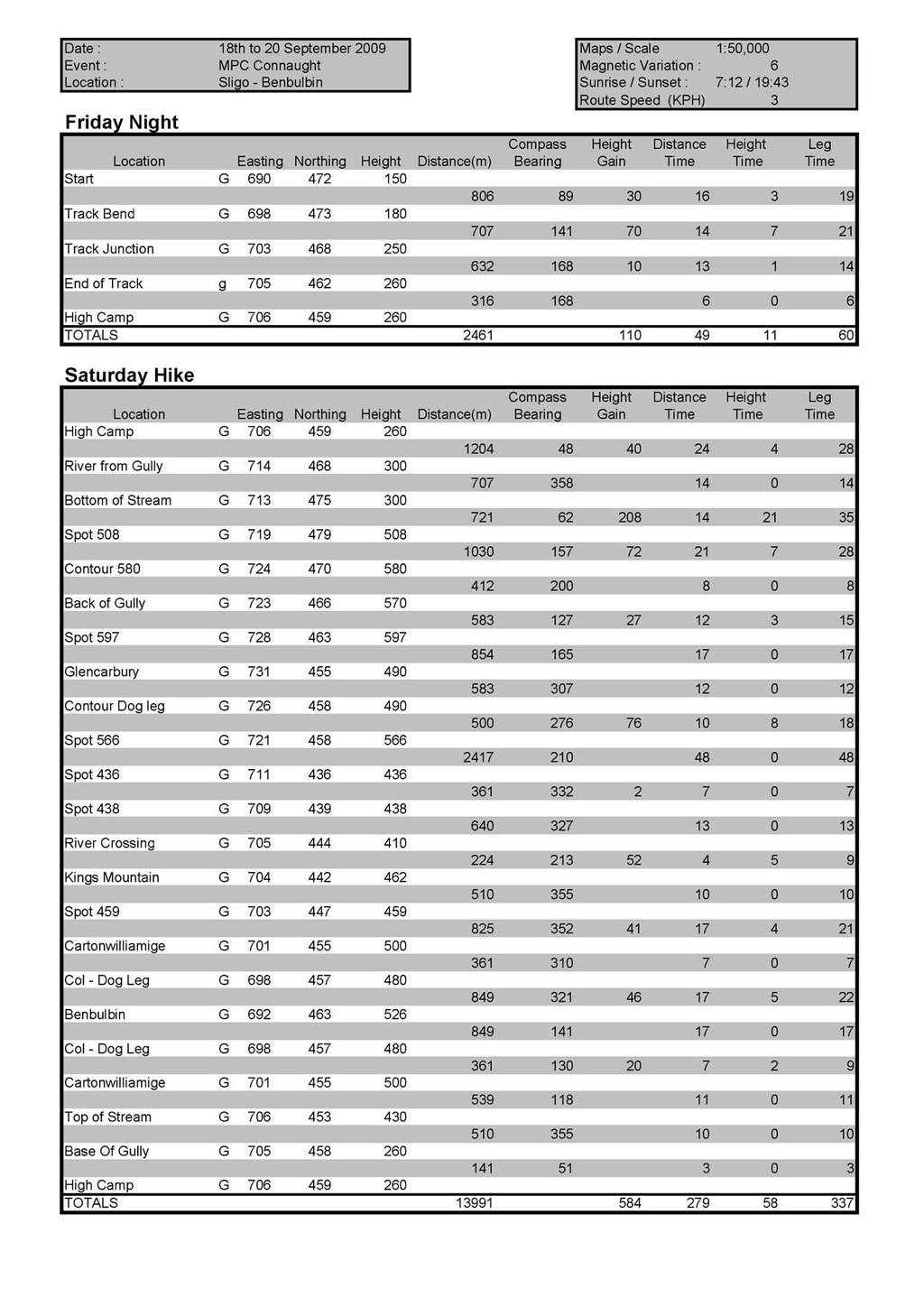
19 Briefing on Sunday Hike This should be done in a clear and concise manner to ensure that every candidate understands the briefing. The importance of route preparation including memorising both the basic route and the surrounding mountains and valleys should be emphasised. Projects One: Mountain Weather 1. Over a five-day period, cut out the weather charts and forecasts from a daily paper or down load from the internet and put in your logbook. Write a report on the changing weather pattern over the five days. It should include information on: Wind Speed and Direction Sunshine Cloud Cover Precipitation (Rain / Snow) Frontal movements Temperature Atmospheric Pressure 2. Find out about the lapse rate and how it would affect you at the summit of a 3000-foot mountain than if you were standing at sea level. 3. Find out about the wind chill factor and how it affects you when hillwalking. Is there a difference at different altitudes and does it vary in wet or dry air? Two: Route Card Draw up a route card using both the classic and visual methods of a MPC/Sionnach Route. The course director should choose a route with at least 20 legs. The one below is of the Connaught MPC (Benbulbin Sligo) and with the attached classic and visual formal. A handout should be given on how to do route cards so the students have a reference point. The copy below shows the technical detail and does not include the weather or group information or start / finish times.
20 Mountain Pursuit Challenge Connaught 2009 Benbulbin, Co. Sligo MAP: Discovery Series No.16. Scale 1:50000, Magnetic Variation 5º (as of 2009) Introduction This autumn we welcome you to the area of Benbulbin which with its impressive profile has always been an eye-catching attraction in that part of the country. The range itself consists of a large, undulating plateau, which spurs off at various points to create the summits of Benbulbin, Benwiskin, Kings Mountain, Truskmore and Tievebaun. Dramatic escarpments provide wonderful views over the surrounding counties and the Atlantic. Unfortunately, a part of the range is difficult to access due to issues of access with land-owners in the area; the Gleniff valley to the north ( the horseshoe road ) in particular has borne the brunt of this. Our route for the weekend will consist of a standing camp on the North side of the range with a day hike on Saturday up and around the plateau (availability of water on the plateau cannot be guaranteed and the access issues and steep cliffs negate any possibility of a high camp). If visibility is good, the route will give you a chance to see many interesting features of the area. Watch out for caves and sink holes and in particular the rocky canyon visible just to the South East of Kings Mountain. In bad weather - or poor visibility due to mist - navigation on the plateau will be particularly difficult. Regardless of visibility the lack of prominent features and/or ridges on the plateau will call for careful compass work, pacing and timing and distance in order to keep on route. We would ask everyone to ensure they practise these skills in advance of the weekend itself. FRIDAY Instructions to Start ( ) Follow the main Sligo to Bundoran road (N 15) to the junction at (sign posted for Ballinatrillick). Travel in a north easterly direction along this minor road to the junction at Turn right here and continue on to forest at Parking is available in the forest at your own risk. Please arrive between 20:00 and 22:00, if you arrive early do not leave until you have checked out with a member of staff. Start to Base Camp ( ) After check in, follow the road to Lukes Bridge ( ). Cross the bridge and follow the track leading off to the right as far as the bridge at Cross this bridge and follow the path which gradually peters out into boggy ground. The base camp is at Make sure to check in with a member of staff before settling down for the night.
21 SATURDAY As this will be a day hike you should leave your tents in position and take what you need (i.e.: food and personal equipment) for the day. This should be evenly distributed among the team - it is not a good idea to bring one rucksack and pass it around. Base camp to bottom of stream ( ) After checking out make your way along the base of the valley to the stream at Take care when crossing this area as some parts are quite boggy. Bottom of stream to Spot height 508m ( ) On reaching the stream, turn right and proceed to make your way up the high ground to the spot height 508. Take your time when ascending as most of your height for the day will be gained on this leg. Spot height 508m to Spot Height 597m ( ) On reaching spot height 508m, make sure to take in the views (especially Benwhiskin to the North) and also plenty of water as this will be one of the last stops on the route to fill water bottles. From spot height 508m make your way up to spot height 597m, as you traverse this route care must be taken as there are sink holes across the plateau equally you must be mindful and careful of the steep drops/cliffs and a gully to the North of you. Visibility permitting you will have great views of both the Gleniff valley to your North, as well as part of the main plateau of Benbulbin itself. Spot height 597m to Glencarbury ( ) On leaving spot height 597m you will observe a fence coming into view. Keeping this fence to your left you begin to make your descent to Glencarbury ( ) care must be taken as there are areas of loose shale under foot when descending. Glencarbury was the location of one of only two barite mines in Ireland. Barite was mined here from 1894 to 1979, with approx. 50,000 tonnes per year being extracted in the latter years of the mining operation. Barite is used as a weighing agent in paint, but in recent times as drilling mud in the oil exploration industry. There is a significant amount of the mine shafts collapsed and as a result the mines themselves are out of bounds. Glencarbury to Spot height 566m ( ) This is open ground with no distinct features so care must be taken when navigating this leg. By practicing contouring around (pick a point in the distance of a similar height and walk to it) you will save on energy and also save you from additional height lost. Spot height 566m is marked by a small cairn. Spot height 566m to Spot height 436m ( ) From spot height 566m descend to spot height 436m and again care must be taken when navigating this leg as there are no distinct features which to navigate from. Visibility
22 permitting there are great views of the Crockauns across the Glencar valley as you descend, while at spot height 436m, you will be able to see the famous Glencar Lake with its crannogs at either end, as well as the valley itself. Spot height 436m to Spot height 438m ( ) Make your way across the river and onto spot height 438m. There is steep ground/drop to your West so care must be taken when traversing to spot height 438m. Spot Height 438m to Kings Mountain (462m) ( ) There is steep ground/gully between spot height 439m and Kings Mountain so you should head in a northerly direction and cross the river at a more shallow point which will make for an easier traverse to Kings Mountain. Kings Mountain is a distinct feature and from its top makes for great viewing on a clear day. Kings Mountain to Spot Height 459m ( ) Descend carefully the side of Kings Mountain and proceed to the spot height 459m, once again the ground has little if any distinctive features, so is an excellent opportunity, regardless of visibility to continue with your compass work including timing, distance and pacing. Spot height 459m to Cartonwilliamoge ( ) Once again the ground between Spot Height and Cartonwilliamoge is featureless, so good navigation is essential, particularly if visibility is impaired. Cartonwilliamoge itself is quite narrow and care must be taken as there is an escarpment/cliff to its immediate North West side. Cartonwilliamoge to Benbulbin ( ) You can with great care not to get to close to the edge use the escarpment/cliff as a hand rail, to proceed towards Benbulbin. On reaching the top of Benbulbin, the ground levels out so be aware at all times of where you are on the map, especially if in poor visibility. There is a trig point at the summit itself which is back from the cliffs giving you no sense of being on a dramatic escarpment. However, you will not be disappointed by the views from here; with good visibility you have a 360 degree panorama. To the North/North West across Donegal Bay lie the Blue Stacks and Slieve League; away to the East is Truskmore with its TV mast which the highest point in Sligo; to the South West is Knocknarea, crowned by a massive cairn (which is reputed to be the tomb containing the remains of Queen Meabh she of the Tain and other exploits); to the South Lough Gill and the Curlew Mountains and northern shores of Co. Mayo. Beneath you and to the north is Streedagh Point where the Spanish Armada famously came to grief in 1592 with the loss of hundreds of lives. If the weather is fine and calm then you may wish to proceed to the top of the escarpment/cliffs a little further on at You and your team must be very careful here and not go to close to the edge of the escarpment/cliff. If you or your team take the option to go to the top of the escarpment/cliff, you must check in with staff in the area when you return from the cliff and before proceeding back towards Cartonwilliamoge.
23 Benbulbin to Cartonwilliamoge ( ) Retrace your steps from Benbulbin to Cartonwilliamoge, you can with great care not to get to close to the edge use the escarpment/cliff to your North East as a hand rail, to proceed towards Cartonwilliamoge. Cartonwilliamoge to Top of Stream ( ) From Cartonwilliamoge and continuing to keep the escarpment/cliff on your left hand side make your way around the top of the stream. Top of Stream to Camp ( ) Care must be taken when making the descent to camp as the ground under foot might be slippery. When you arrive at camp be sure to check in with a member of staff. SUNDAY Camp to Finish ( ) On breaking camp pack all your gear and ensure that your site(s) are clean and completely litter free, only leave when your site(s) have been inspected and you have been checked out by a member of staff. Remember that all litter must be taken away. Our route out is along the same route that we took in on the Friday night. Be sure to check in with a member of staff when you get back to the finish. Well done on completing the Connaught MPC 2009.
24

25 Note one of the Saturday legs is shown as going over a cliff edge. It is important for the students to realise this and learn the principle that a bearing gives a direction but that on a specific bearing that there are often obstacles that need to be bypassed as in the graphic below
26 Basic Route Card for Hikes and Expeditions
27

28
29 Day Two Day Hike minimum of 6 hours on hillside. The activity should not be persistent training as the Scouts should enjoy the hike. However the instructors should ensure that all participants get an opportunity to lead using map, compass, timing and pacing. The following are a list of practical exercises that should be undertaken with each group. Map Reading Be able to identify all major map symbols Be able to set a map by linear features Understand the principles of contour lines & features Walk to a steep slope, assess the ground, and relate the ground to the map Walk to a shallow angled slope, assess the ground, and relate the ground to the map Walk to a spur, assess the ground, and relate the ground to the map Walk to a re-entrant, assess the ground, and relate the ground to the map Walk to a hilltop, assess the ground, and relate the ground to the map Choose a distant feature (500m-1 km), Calculate distance and estimate how long the journey might take. Walk & reassess Self-location, a systematic approach. Analyse the ground using down slope, up slope, to the left and to the right. Relate that information to the map Choose a Col, 500m-1km distant, estimate distance, and estimate how long the journey might take. Walk & reassess Stand on the Col, assess the ground, and relate the ground to the map Introduction to the national grid, 1km on the side 1.5km on the diagonal Practice rough distance measurement Walk to a distinct change of slope, assess the ground, and relate the ground to the map Walk to a feature out of sight using a tick list to find the way. Choose a Collecting feature or a 'one feature too far' Timing and Pacing Pacing exercise on flat ground Measurement of distance using the romer Measure the distance to a feature on the hill; circa 200m-300m. Over easier Terrain. PACE. Instructor offers guidance to 'roughly what is Measure the distance to a feature on the hill; circa m, travelling uphill. Compare to previous results Measure the distance to a feature on the hill; circa m, travelling down hill Introduction to timing. Easier timed legs, more than 500m.Try to keep the height time much less than the distance time Over lunch, introduction to the compass, initially map setting then taking basic bearings. Navigating to features out of sight approx. 500m away using timing, Pacing, map setting using the compass and using a tick list Navigating to features out of sight more than 500m away using timing, pacing, following an elementary bearing and using a tick list. (General Direction not compass bearing)
30 Compass work Revision of map reading, self-location, timing and pacing Revision of compass work, introduction to magnetic variation Combined navigation techniques; choosing the correct technique for a given leg Aiming off and collecting features Converting magnetic bearings back to grid bearings Grid references
31 Weekend Two Review of Progress to Date This should be a brief discussion and feedback session with the opportunity to clarify any arising issues. Review Self Assessment (what I have learnt and what do I still need to learn) Ask the students to review their sheets and in a different colour pen ask them to see if they would change any of their ticks in columns. Then have a discussion on the changes. Depending on the grouping / trainers this may well have increased towards the very competent, from a low base, as the students have learnt on the first weekend and over the projects. Or it may well have reduced because students who have self assessed at a competent level have realised that there is a lot more to the skill than they thought. Review of Projects Review the two projects: Weather and Route Card. Have a handout on weather available to give out and a copy of the completed route card in both classic and visual formats. Mountain Camping Equipment Discussion in a semi circle with a fully packed expedition rucksack with good examples and perhaps the odd red herring to start a discussion and create a memory in the students (example very heavy gas stove). Encourage input from the students and write up their recommended gear list on a board as well as having a handout. A concentration should be made on readily available / price affordable equipment such as Trangias (gas version) and platypus drinking systems that enhance the experience on the hills by making life a lot easier for a Scout on an expedition. Tent Pitching & Striking Low Light / Blindfolded Students should bring their own tent (troops) and pitch it. The second pitch should be done blindfolded (to see of a student really knows their tent). The main trick here is rcognising the poles and where they go. A simple extra piece of material can be clipped to one of the peg points to allow the student to ID their position around the tent. This requires lots of space. Cook Lunch on Mountain Stove Students should prepare and cook their lunch on a mountain stove. This will show the limitations of the model (i.e. frying on a meths trangia will take hours), as well as what the stove is capable of. A full meal should be cooked from scratch and not a pot noodle. This also includes cleaning up. Instructors should also discuss the safety aspects of some of the commonly available stoves and fuel bottles
32 As part of the Equipment Talk a trangia or other stove & pot system should be shown with a pot scrub, a small bottle of washing up liquid and a rubbish bag packed inside it. Menu Planning This should cover the whole food pyramid, and emergency planning to deal with hypoglycaemia and hypothermia. Include the LNT concept of Plan ahead and Prepare where all rubbish is left at home, and the concept of cook at home and reheat. Also cover the number of pots and pans available and what wash up is required, important in cold weather, and also foods that taint the pots if not very well washed. Mountain Emergencies & First Aid Recap of Basic First Aid preferably using the REC (Rescue Emergency Care) ABCDE method. The Specific Skills required to stage 6 are: Calling the Emergency Services Simple Strains and Blisters Wilderness Triad (Hypothermia / Hypoglycaemia & Dehydration) Sunstroke & Heat related injuries Asthma Buddy System & following the Instruction of the leader These should all be recapped in the session, if the student wants further knowledge then they should do an outdoor first aid cert to level 2 (2 days) at a minimum The Hillwalking Adventure Skill team have both Mountain Leader First Aid Kits and survival shelters that are available to loan out. Mountain Hazards & Escape Routes Cover in some detail including when to use an escape route. Discussion on Group Awareness Group Discussion introducing the stage 6 requirements I know the limitations of my team
33 Projects Project One Menu Planning for Expedition Set the project to develop the menu for the expedition weekend and to look at both the calorific intake and the cost (budget aspect of skill badge). The students should also have calculated the cook times and the required fuel needed. In an ideal situation the pots & pan utilisation should also be calculated as well as the total weight of food / fuel carried. Project Two Route Card for Expedition Give the students the route plan for the expedition in a similar format to the one for the Sligo MPC above and have them create route cards (classic and visual) for the expedition weekend. Day Two Day Hike minimum of 6 hours on hillside. This should be run in the same way as Day Two of Weekend One
34 Weekend Three Expedition Weekend A two night mountain camping trip using a low and a high camp and using all the skills learned to date The entire course is leading up to the expedition and this should be treated as the highlight of the course rather than as the assessment. The method of assessment should be based on leading legs, discussion and observation of the student over the course of the expedition. Should the assessor feel that the student needs a bit more work on a certain area they should be facilitated. This activity should be run as a training and assessment exercise for all involved and not as a test of stamina and endurance. It is therefore not recommended that full MPC / Sionnach routes should be re-run although the campsites used on these events may be useful, and modified versions of these routes may prove useful. The Assessors should ensure that each student is capable of Map Reading Be able to identify all major map symbols Be able to set a map by linear features Understand the principles of contour lines & features Walk to a steep slope, assess the ground, and relate the ground to the map Walk to a shallow angled slope, assess the ground, and relate the ground to the map Walk to a spur, assess the ground, and relate the ground to the map Walk to a re-entrant, assess the ground, and relate the ground to the map Walk to a hilltop, assess the ground, and relate the ground to the map Choose a distant feature (500m-1 km), calculate distance and estimate how long the journey might take. Walk & reassess Self-location, a systematic approach. Analyse the ground using down slope, up slope, to the left and to the right. Relate that information to the map Choose a Col, 500m-1km distant, estimate distance, and estimate how long the journey might take. Walk & reassess Stand on the Col, assess the ground, and relate the ground to the map Introduction to the national grid, 1km on the side 1.5km on the diagonal Practice rough distance measurement Walk to a distinct change of slope, assess the ground, and relate the ground to the map Walk to a feature out of sight using a tick list to find the way. Choose a collecting feature or a 'one feature too far' Timing and Pacing Pacing exercise on flat ground Measurement of distance using the romer
35 Measure the distance to a feature on the hill; circa 200m-300m. Over easier Terrain. PACE. Instructor offers guidance to 'roughly what is Measure the distance to a feature on the hill; circa m, travelling uphill. Compare to previous results Measure the distance to a feature on the hill; circa m, travelling down hill Introduction to timing. Easier timed legs, more than 500m.Try to keep the height time much less than the distance time Over lunch, introduction to the compass, initially map setting then taking basic bearings. Navigating to features out of sight approx. 500m away using timing, pacing, map setting using the compass and using a tick list Navigating to features out of sight more than 500m away using timing, pacing, following an elementary bearing and using a tick list. (General Direction not compass bearing) Compass work Revision of map reading, self-location, timing and pacing Revision of compass work, introduction to magnetic variation Combined navigation techniques; choosing the correct technique for a given leg Aiming off and collecting features Converting magnetic bearings back to grid bearings Grid references Camping and Cooking Pick a good camp site and review the possibility of flooding and LNT principles (Durable Ground) Pitch their tent well with attention paid to wind direction Cook an edible and nutritious meal on a mountain stove and be able to clean up and dispose of waste properly (LNT) Mountain Safety & Emergencies Whilst hiking discuss with the assessor an emergency action plan for a scenario incident at that point on the route Develop an escape route from this point 5 Celebration Depending on the nature of the course the presentation of the awards may be done on the last morning of the expedition (MPC Style) or at a more formal occasion a few weeks later (max 3 weeks). All logs should be submitted for signing as they are necessary for level 7
36 6 Instruction and Assessment Ratios In order to assure that the best quality instruction the recommended ration of instructors to students should be 1 to 4, with an absolute maximum of 6 to one. Where stage seven instructors are working under a stage 8/9 course director there should be no more that 2 stage 7 s per every stage 8/9. This would mean that the recommended ratio would be 12 students per stage 8/9 instructor with a maximum of 18 In order to assure that the course is not a crowd control exercise the recommended maximum number per course is 24 Students as this requires 2 stage 8/9 instructors, they should work as joint course directors.
37 Hillwalking Adventure Skills Logbook NAME: ADDRESS: PHONE: (H) (M) E MAIL ADDRESS: How long have you been hill walking? Have you any rock climbing experience? How many different hills higher than 600m have you ascended? How many different hills higher than 800m have you ascended? How many different hills higher than 1000m. have you ascended? Have you any mountaineering experience abroad? If so, where? DATES OF SKILLS COURSES ATTENDED Organiser s Signature Date: Course Organiser Hillwalking Stages Awarded Assessor s Signature Stage: Date: Location: Assessor: Five Six Seven FIRST AID CERT: Level of Cert Issuing Body Date of Cert Valid until
38 Example Logbook Entry Hike Number 1 Date 21/09/2010 Area - Glenbride, Co Wicklow Map: Sheet 56 1:50,000 Number in Party: 4 Leader: Andy White Weather: Mild, Light winds with low clouds and showers Total Distance 15km Total Time: 6 Hours Campsite Location N/A Route Route Notes Glenbride Lodge Spot 698m Marked as Silsean on some maps Moanbane Billy Byrne s Gap Mullaghcleevaun I led this Leg Barnacullian Spot 561m Marked as Carrignagunneen on some Maps Glenbride Lodge Sketch Map of Route If there is insufficient space on the page please photocopy and write on the back Full route cards should be submitted where necessary
39 Hillwalking Stage 4 Hike Number 1 Hike Number Area - Number in Party: Date Map: Leader: Weather: Total Distance Total Time: Campsite Location: Route Route Notes Sketch Map of Route If there is insufficient space on the page please photocopy and write on the back Full route cards should be submitted where necessary
40 Hillwalking Stage 4 Hike Number 2 Hike Number Area - Number in Party: Date Map: Leader: Weather: Total Distance Total Time: Campsite Location: Route Route Notes Sketch Map of Route If there is insufficient space on the page please photocopy and write on the back Full route cards should be submitted where necessary
41 Hillwalking Stage 4 Hike Number 3 Hike Number Area - Number in Party: Date Map: Leader: Weather: Total Distance Total Time: Campsite Location: Route Route Notes Sketch Map of Route If there is insufficient space on the page please photocopy and write on the back Full route cards should be submitted where necessary
42 Hillwalking Stage 5 Hike Number 1 Hike Number Area - Number in Party: Date Map: Leader: Weather: Total Distance Total Time: Campsite Location: Route Route Notes Sketch Map of Route If there is insufficient space on the page please photocopy and write on the back Full route cards should be submitted where necessary
43 Hillwalking Stage 5 Hike Number 2 Hike Number Area - Number in Party: Date Map: Leader: Weather: Total Distance Total Time: Campsite Location: Route Route Notes Sketch Map of Route If there is insufficient space on the page please photocopy and write on the back Full route cards should be submitted where necessary
44 Hillwalking Stage 5 Hike Number 3 Hike Number Area - Number in Party: Date Map: Leader: Weather: Total Distance Total Time: Campsite Location: Route Route Notes Sketch Map of Route If there is insufficient space on the page please photocopy and write on the back Full route cards should be submitted where necessary
45 Additional Logs (Photo Copy as Necessary) Hike Number Area - Number in Party: Date Map: Leader: Weather: Total Distance Total Time: Campsite Location: Route Route Notes Sketch Map of Route If there is insufficient space on the page please photocopy and write on the back Full route cards should be submitted where necessary
46 Additional Logs (Photo Copy as Necessary) Hike Number Area - Number in Party: Date Map: Leader: Weather: Total Distance Total Time: Campsite Location: Route Route Notes Sketch Map of Route If there is insufficient space on the page please photocopy and write on the back Full route cards should be submitted where necessary
47 Additional Logs (Photo Copy as Necessary) Hike Number Area - Number in Party: Date Map: Leader: Weather: Total Distance Total Time: Campsite Location: Route Route Notes Sketch Map of Route If there is insufficient space on the page please photocopy and write on the back Full route cards should be submitted where necessary
48
One Programme Adventure Skills. Hillwalking Logbook. Version Aug-11
 One Programme Adventure Skills Hillwalking Logbook Version 2013.1 Aug-11 Name Address Hillwalking Personal Record Log Phone (H) (M) Email Address Date Logbook Started How long have you been hill walking?
The Mountains are for Everyone. Hillwalking Adventure Skill General Guidance Stages 1 to 9
 The Mountains are for Everyone Hillwalking Adventure Skill General Guidance Stages 1 to 9 Hill Walking Adventure Skills Key Elements Part of the Larger ONE programme roll out A 9 Stage Scheme from first
Below is an example of a well laid-out template of a route card used by the Sionnach Team which is a good format to begin with.
 Route Card A route card is used as a navigational aid to hill walkers by setting out a step by step plan for an intended hike. It is good practice to make out a route card before every hike you or your
Hillwalking. Hillwalking Adventure Skill
 Hillwalking Hillwalking Adventure Skill External qualification BOS - the Irish Mountain Training Board in the South and MLTNI in Northern Ireland run a number of Mountain Leadership courses. Those who
Preparing for A Crew Expedition
 Preparing for A Crew Expedition A Venture Scout Crew Expedition looks something like: A crew hiking (or walking, cycling, sailing) and camping independently A Crew Leader and an Assistant Crew Leader leading
Camping Merit Badge Workbook
 Merit Badge Workbook This workbook can help you but you still need to read the merit badge pamphlet. This Workbook can help you organize your thoughts as you prepare to meet with your merit badge counselor.
Backpacking Merit Badge Workbook
 Merit Badge Workbook This workbook can help you but you still need to read the merit badge pamphlet. The work space provided for each requirement should be used by the Scout to make notes for discussing
CAMPING SKILLS I can collect small sticks for a campfire. 1.4 I can keep my camping gear neat and tidy.
 CAMPING SKILLS 1 1.1 I can collect small sticks for a campfire. Scouts can search for and return with some dry sticks for starting a campfire. Scouts can separate tinder, lightweight sticks and logs. 1.2
Scout s Name: Counselor s Name: Counselor s Ph #:
 CAMPING MERIT BADGE WORKSHEET This worksheet is not required but is designed to help you with this merit badge. Requirements revised: 2OO6, Worksheet updated: 2006. Scout s Name: Date: Counselor s Name:
OUTDOOR ADVENTURE SKILLS
 1 S Competencies 1.1 I can collect small sticks for a campfire. 1.2 I can follow directions while at camp. 1.3 I can help pack a bag for camp. 1.4 I can keep my camping gear neat and tidy. 1.5 I can care
Minimum Knowledge Expected of Learner
 Unit 1 Developing outdoor leadership skills Know the roles and responsibilities of an Assistant Basic Expedition Leader. Be able to apply the skills of an Assistant Basic Expedition Leader. Know the importance
Scout s Name: Counselor s Name: Counselor s Ph #:
 BACKPACKING MERIT BADGE WORKSHEET This worksheet is not required but is designed to help you with this merit badge. Requirements revised: 2002, Worksheet updated: January 2004. Scout s Name: Date: Counselor
Outdoor Adventure Skill Badges
 Outdoor Adventure Skill Badges Outdoor Adventure Skills are important skills associated with Scouting. Nine areas of skills are part of every Scouting Section, from Beaver Scouts to Rover Scouts. Each
CAMPING Merit Badge Requirements
 Scout Name: Unit #: Date: CAMPING Merit Badge Requirements 1) Show that you know first aid for and how to prevent injuries or illnesses that could occur while camping, including hypothermia, frostbite,
Ranger Award Core Requirements
 Ranger Award Core Requirements CORE REQUIREMENTS Do all of the following core requirements. 1. First Aid Complete a standard first aid course plus the American Red Cross When Help Is Delayed module or
Backpacking Merit Badge Workbook
 Merit Badge Workbook This workbook can help you but you still need to read the merit badge pamphlet. The work space provided for each requirement should be used by the Scout to make notes for discussing
The following reference material provides useful information about this Adventure Skill.
 Camping Camping Adventure Skill Reference Material The following reference material provides useful information about this Adventure Skill. Note: It is not possible to study for an Adventure Skill. Knowledge
Overnight Hike Activity Plan
 Overnight Hike Activity Plan CONTENTS Outcomes... 2 Activity... 2 2.1 Outline... 2 2.2 Equipment... 2 2.3 Communication... 3 2.4 First Aid... 3 People... 3 3.1 Activity Instructor... 3 3.2 School Staff
GOLDEN EARS PROVINCIAL PARK
 GOLDEN EARS PROVINCIAL PARK Trail Information as of October 10 th 2015 Do not underestimate the mountainous wilderness of Golden Ears Provincial Park. The combination of rugged terrain and rapidly changing
Scout Skills - Campsite Layout and Selection
 Scout Skills - Campsite Layout and Selection S Item Code FS315071 May/05 Edition no 2 (103759) 0845 300 1818 Camping is very much part of Scouting, an activity undertaken by most Members at one time or
CAMPING Merit Badge Requirements
 Scout Name: Unit #: Date: CAMPING Merit Badge Requirements 1) Show that you know first aid for injuries or illnesses that could occur while camping, including hypothermia, heatstroke, heat exhaustion,
J A N U A RY
 DUKE OF EDINBURGH J A N U A RY 2 0 1 9 WHAT IS DUKE OF EDINBURGH? An internationally recognised award programme for young people aged 14-25 Founded in 1956 by the Duke of Edinburgh and has now expanded
Camping Merit Badge Workbook
 Merit Badge Workbook This workbook can help you but you still need to read the merit badge pamphlet. The work space provided for each requirement should be used by the Scout to make notes for discussing
Expedition and Outdoor Leadership Certificate Guidance Note for BB Leaders : 2017
 Expedition and Outdoor Leadership Certificate Guidance Note for BB Leaders : 2017 The regulations for Leaders are set out in Appendix A2 of the BB Safety Manual 2009, as amended by Brigade Executive in
DofE TRAINING PACK 2018
 SCHOOL CAMP Ltd, Unit 1, Old Legions Place, Resolven, Neath. SA11 4NJ. Tel: 01639 710348 Email: info@schoolcamp.co.uk DofE TRAINING PACK 2018 SCHOOL GROUP ID Participants name edofe number 1 2 3 4 5 6
The Atlas of Hillforts of Britain and Ireland. Hillfort survey notes for guidance
 The Atlas of Hillforts of Britain and Ireland Hillfort survey notes for guidance The collection of surveys for the Atlas is now finished but you can use this form and the accompanying Notes for Guidance
General Skills Task list
 General Skills Task list Name Official Start Completion Trainee Training /s Trainer/s Participate in Candidate Training and get on Peak Adventures payroll Complete Candidate Task List Pay for and attend
SCOUTING. Because without OUTING it would just be SC
 SCOUTING Because without OUTING it would just be SC Camping Merit Badge Camping is one of the best-known methods of the Scouting movement. When he founded the Scouting movement in the early 1900s, Robert
Leave No Trace. Provide ground rules: Note taking is encouraged Handouts at end of presentation Ask questions when you have them S
 Leave No Trace Provide ground rules: Note taking is encouraged Handouts at end of presentation Ask questions when you have them 1A Learning Objectives To emphasize the importance of using Leave No Trace
Self-Guided Walk Langdale Pikes. Start & Finish: NT car park (free to members) at Sticklebarn - on the right just beyond the New Dungeon Ghyll hotel.
 at Sticklebarn - on the right just beyond the New Dungeon Ghyll hotel.") Self-Guided Walk Langdale Pikes Key Information These mountains form a collection of spires and cliffs on the north side of Langdale. This walk visits four of the main tops Pavey Ark, Harrison Stickle,
Self-Guided Walk Langdale Pikes Key Information These mountains form a collection of spires and cliffs on the north side of Langdale. This walk visits four of the main tops Pavey Ark, Harrison Stickle,
Wicklow Mountains Path Survey
 Wicklow Mountains Path Survey Glenmacnass Tonelagee Start to Finish: O 114 030 to O 085 016 Altitude (lowest highest): 370m 817m Weather: Sunny day, hot Access: Military Road, Glenmacnass Surveyed by:
Plan Outdoor Recreation Activities / Use and Maintain a Temporary or Overnight Campsite
 REVIEW BOOKLET PATHFINDER LEADERSHIP AWARD SIOODR001 / SIOOPS005 Plan Outdoor Recreation Activities / Use and Maintain a Temporary or Overnight Campsite Review Booklet Name Date Introduction This Review
Event Details. When Friday, January 16th -18 th Check-in: Begins Friday, January 16 th at 17h00 Check-out: Sunday, January 18 th at 09h00
 Hello and welcome! Thank you for your interest in leaving not a trace and attending Maketewa District s 2015 Klondike Derby. The event will be hosted by Troop 150, for their twelfth year. We hope that
Control Description Sheet 1
 Control Description Sheet 1 Headings I0A Example M20 M21 M35 1 8.8km 250m Event Title Classes (optional) Course Code; Course length, Height climb Start location as if it was a control. First Control Description
Dades Gorge TREK DESCRIPTION LOGISTICS HIGH ATLAS MOUNTAINS
 TREK GUIDE MOROCCO Dades Gorge HIGH ATLAS MOUNTAINS PEAK Adventure Travel Marrakech t: + 212 (0) 668 468 595 t: + 212 (0) 524 334 770 e: Redouane.ElMouatasim@peakdmc.com www.peakdmc.com TREK DESCRIPTION
Aconcagua Leadership and Guide Training Course
 Aconcagua Leadership and Guide Training Course Cerro Aconcagua is located in the central Andes of Argentina near the border with Chile. At 22,841ft (6,962m), it is one of the seven summits and the only
Open Polar Expedition Training USA. Turpin Meadow Ranch
 Open Polar Expedition Training USA Turpin Meadow Ranch The purpose of the Polar Training Course is to prepare individuals for participation in a polar expedition such as skiing long distance or last degree
SHELTERS, OUTDOOR SURVIVAL AND ORIENTEERING REVIEW PAD30
 SHELTERS, OUTDOOR SURVIVAL AND ORIENTEERING REVIEW PAD30 Before you Build your shelter you should consider the following: Hours Before Dark Close to dark = build something easy Season Summer = Higher ground
Camp Roosevelt February 22-24, 2019 The High Adventure Chill Out is a chance to join in one of the oldest traditions in Boy Scout history.
 Camp Roosevelt February 22-24, 2019 The High Adventure Chill Out is a chance to join in one of the oldest traditions in Boy Scout history. It's a wonderful opportunity for units to come together as a Council
Itinerary Overview: What you will be doing Maroon Bells Alpine Backpacking 22 days
 Itinerary Overview: What you will be doing Maroon Bells Alpine Backpacking 22 days 0BCourse Description Welcome, you re in for an experience of a lifetime! Imagine hiking through rolling forests, sharing
Itinerary Overview. Sangre de Cristo Alpine Backpacking 22 days Ages Course Description
 Itinerary Overview Sangre de Cristo Alpine Backpacking 22 days Ages 16-18 Course Description Welcome, you re in for an experience of a lifetime! Imagine hiking through rolling forests, sharing alpine meadows
Itinerary Overview. Continental Divide Alpine Backpacking 22 days Ages Course Description
 Itinerary Overview Continental Divide Alpine Backpacking 22 days Ages 16-18 Course Description Welcome, you re in for an experience of a lifetime! Imagine hiking through rolling forests, sharing alpine
ID: 283 Distance: 6.2 miles Height gain: 500 Metres Map: Explore OL 19 Contributor David and Chris Stewart
 Walkingworld Wild Boar Fell ID: 283 Distance: 6.2 miles Height gain: 500 Metres Map: Explore OL 19 Contributor David and Chris Stewart Features Birds, Great Views, Hills or Fells Description: Wild Boar
Outdoor Skills Patch Program
 Overview The is a progressive, six-level program to help Girl Scout Daisies through Ambassadors learn and become proficient in outdoor skills. Through this patch program, girls explore leadership, build
CBD 2014 Spring Camporee. Backpacking Merit Badge Course Description and Bring With List
 Backpacking Merit Badge Course Description and Bring With List This course is intended for scouts ages 13 or older who want an introduction to backpacking. It is good preparation for an upcoming first
Backpacking Trip Planning. Presenters: Dana Perry Christine Fogarty
 Backpacking Trip Planning Presenters: Dana Perry Christine Fogarty 1 Agenda New to planning trips? Location and physical trail Common terminology Trip selection & research The Trip Flow Plan What is it
Itinerary Overview. Colorado San Juan Mountaineering 15-days
 Itinerary Overview Colorado San Juan Mountaineering 15-days Course Description Welcome, you re in for an experience of a lifetime! Imagine hiking through rolling forests, sharing alpine meadows with mountain
Information and Rules GMC 2016 Updated 14 th May 2016
 Information and Rules GMC 2016 Updated 14 th May 2016 Final details will be confirmed on the Grampian Orienteering Club website 1 week before the event. If the event is cancelled due to bad weather, this
Preparing for Patrol Camp
 Preparing for Patrol Camp A patrol camp looks something like: A patrol camping independently A PL and APL leading the Patrol Scouts camping and cooking for themselves Scouts running their own programme
Introduction Syllabus Sample Mountain Skills1 & 2 programmes Mountain Skills Assessment Sample Questions from sample written test
 Contents Introduction... 1 Syllabus 1. Mountain Skills Scheme & Mountaineering Ireland... 3 2. Mountain hazards... 3 3. Mountain Environment... 3 4. Maps... 4 5. Navigation... 4 6. Route planning... 4
Itinerary Overview. Maroon Bells Mountaineering 22-days. Course Description
 Itinerary Overview Maroon Bells Mountaineering 22-days Course Description Welcome, you re in for an experience of a lifetime! Imagine hiking through rolling forests, sharing alpine meadows with mountain
OUTDOOR ADVENTURE SKILLS
 1 Competencies 1.1 I have built something out of snow. 1.2 I have prepared a good snack for a winter outing. 1.3 I always carry a water bottle when going on a winter outing. 1.4 I can keep my water bottle
wilderness survival scouting outcomes advancement opportunities 105
 Wilderness Survival Early man practiced wilderness survival because he had to. We practice it today because it is a challenge and because even today we might confront a situation requiring knowledge of
FAQ for the Alpine Scrambling Program (Rev: 12/18/2018)
") FAQ for the Alpine Scrambling Program (Rev: 12/18/2018) What if I need to withdraw? Denver Group school refund policy is as follows: Student/participant requests for refunds of tuition/fees must be requested
FAQ for the Alpine Scrambling Program (Rev: 12/18/2018) What if I need to withdraw? Denver Group school refund policy is as follows: Student/participant requests for refunds of tuition/fees must be requested
Aviation Merit Badge Workbook
 Merit Badge Workbook This workbook can help you but you still need to read the merit badge pamphlet. The work space provided for each requirement should be used by the Scout to make notes for discussing
BACKGROUND INFORMATION
 BRONZE DUKE OF EDINBURGH S AWARD TRAINING, PRACTICE AND QUALIFYING EXPEDITIONS 2017-2018 BACKGROUND INFORMATION Dear Parent/Guardian and Student, Please find enclosed the information that you will need
BSA Leave No Trace 101 Course Guide
 Page 1 Introductory Guidelines for Instructors BSA Leave No Trace 101 Course Guide Course length: Instructor: 3 or more hours, timing for each section is provided as a guideline only. Leave No Trace Trainer
Camp Jack Wright PERMANENT ORIENTEERING COURSE (2004)
") Camp Jack Wright PERMANENT ORIENTEERING COURSE (2004) WHAT IS ORIENTEERING? The skill which enables a person to navigate with a map. In the competitive sport, the winner is the person who finishes in the
Camp Jack Wright PERMANENT ORIENTEERING COURSE (2004) WHAT IS ORIENTEERING? The skill which enables a person to navigate with a map. In the competitive sport, the winner is the person who finishes in the
Itinerary Overview. Sawatch Range Mountaineering Ages days
 Itinerary Overview Sawatch Range Mountaineering Ages 14-16 22 days Course Description Welcome, you re in for an experience of a lifetime! Imagine hiking through rolling forests, sharing alpine meadows
Outdoor Life Trail Badge Worksheet
 1. Explain why weather, water, and lay of the land are important when choosing and setting up camp. Date Completed Verified By 2. Describe and demonstrate methods to secure food from wild animals, bad
Victoria Falls Lookout to Blue Gum Forest
 Victoria Falls Lookout to Blue Gum Forest 8 hrs Experienced only 13.8 km One way 5 112m This long day-walk follows a remote track down from Victoria Falls lookout, passing the waterfall, and into the Grose
Leave No Trace. Prepared for Boy Scout Troop 63 Woodbridge, CT
 Leave No Trace Prepared for Boy Scout Troop 63 Woodbridge, CT What is Leave No Trace? Leave No Trace is a program that evolved from outdoor codes taught by the United States Forest Service, the Bureau
PERUVIAN ANDES ADVENTURES. ARTESONRAJU CLIMB 6025m (19767 ft) Grade: D+ to TD/ Technical. Routes: The two routes to climb Artesonraju are;
 Grade: D+ to TD/ Technical. Routes: The two routes to climb Artesonraju are;") PERUVIAN ANDES ADVENTURES ARTESONRAJU CLIMB 6025m (19767 ft) Grade: D+ to TD/ Technical Routes: The two routes to climb Artesonraju are; *Via the Paron Valley South East Ridge 5 days (option for 6 with
PERUVIAN ANDES ADVENTURES ARTESONRAJU CLIMB 6025m (19767 ft) Grade: D+ to TD/ Technical Routes: The two routes to climb Artesonraju are; *Via the Paron Valley South East Ridge 5 days (option for 6 with
TANZANIA CIVIL AVIATION AUTHORITY AIR NAVIGATION SERVICES INSPECTORATE. Title: CONSTRUCTION OF VISUAL AND INSTRUMENT FLIGHT PROCEDURES
 Page 1 of 8 1. PURPOSE 1.1. This Advisory Circular provides guidance to personnel involved in construction of instrument and visual flight procedures for publication in the Aeronautical Information Publication.
Geocaching Activity Plan
 Geocaching Activity Plan CONTENTS Outcomes... 2 Activity... 2 2.1 Outline... 2 2.2 Equipment... 2 2.3 Communication... 3 2.4 First Aid... 3 People... 3 3.1 Activity Instructor... 3 3.2 School Staff Member
Figure 1 Understanding Map Contours
 Figure 1 Understanding Map Contours The light brown lines overprinted on topographic maps are called contour lines. They indicate the elevation above sea level of land features and thus permit you to view
Basic Bushwalking Skills Certificate. Assessment Package
 Basic Bushwalking Skills Certificate Assessment Package Basic Bushwalking Skills Aligning with National Outdoor Recreation Modules E:\Contract Work\Andrew Govan\Bushwalking Leadership\2015-09-11 Basic
MT TASMAN GUIDED ASCENT 2017/18 TRIP NOTES
 MT TASMAN GUIDED ASCENT 2017/18 TRIP NOTES Mount Tasman / Horo Koau Trip Notes All material Copyright Adventure Consultants Ltd 2017-2018 Mount Tasman (3,498m / 11,378ft) is considered by many to be the
DoE Route Setting and Activity
 DoE Route Setting and Activity How long should each day last? Expedition Level Duration Daily Activity Bronze Level 2 Days and 1 Night 6 Hours of planned activity Silver Level 3 days and 2 Nights 7 Hours
Sequoia Council Boy Scouts of America 2018 Leader s Guide 0
 2018 Leader s Guide 0 Overview This event will feature competitive/cooperative events, exhibits, awards, a Survival themed movie, adult training opportunities, and plenty of scout spirit! We want units
Cub Scout Den Meeting Outline
 Cub Scout Den Meeting Outline Month: April Week: 2 Point of the Scout Law: Thrifty Before the Meeting Gathering Opening Discussion Activity Business items/take home Closing After the meeting Tiger Wolf
NZQA registered unit standard version 2 Page 1 of 8. Demonstrate flying skills for a commercial pilot licence (aeroplane)
") Page 1 of 8 Title Demonstrate flying skills for a commercial pilot licence (aeroplane) Level 5 Credits 10 Purpose People credited with this unit standard are able, for a commercial pilot licence (aeroplane),
Page 1 of 8 Title Demonstrate flying skills for a commercial pilot licence (aeroplane) Level 5 Credits 10 Purpose People credited with this unit standard are able, for a commercial pilot licence (aeroplane),
Before leaving the campsite make sure that nothing has been left and especially make sure that there is no litter lying around.
 B.10(b) CAMEL TREKKING 1 Peter Drake Revised 2008 An exciting venture is the camel trekking expedition and the following notes aim to help expeditioners when on the trek. Trekking with camels is a great
Bronze Duke of Edinburgh Award
 Bronze Duke of Edinburgh Award What is the Duke of Edinburgh Award? The DofE is the world s leading youth achievement award, giving millions of 14 to 24-year-olds the opportunity to be the very best they
Leaden Boot Challenge ROUTE INSTRUCTIONS
 Leaden Boot Challenge ROUTE INSTRUCTIONS Section 1 Alstonefield to Ilam From the village hall car park turn R then L and pass through the village keeping to the R to enter Church Street. Pass the Church
Mt. Rainier Three-Day Muir Climb
 Mt. Rainier Three-Day Muir Climb Details below provided by AAI Elevation: 14,411 feet Guide Service: Alpine Ascents International (AAI) Fundraising minimum: $5,000.00 USD Muir Three-Day Overview Our three-day
Mind Hike, The Lakes September 2017
 I made new, life-long friends and smashed what I thought were my own personal limits. Mind Hike, The Lakes September 2017 Registration fee: 85 Minimum sponsorship 675 www.mind.org.uk/hike2017 Reg. Charity
 HILL & MOUNTAIN SKILLS SCHEME SCHEME HANDBOOK www.mountain-training.org CONNECT WITH US PREFACE This booklet contains all the information needed to progress through the Hill & Mountain Skills Scheme. In
Ranger Award Electives Backpacking
 Ranger Award Electives Backpacking 1. Develop a personal exercise plan and follow it for at least three months, exercising at least three times a week. Set your goals with backpacking in mind and write
Guide Training Ski TAP APPLICATION PACKAGE. Hello and thank you for your interest in applying to the ACMG Training and Assessment Program (TAP).
.") Hello and thank you for your interest in applying to the ACMG Training and Assessment Program (TAP). As of April 30, 2018, the ACMG will be running the program for an undetermined period. For any courses
Hello and thank you for your interest in applying to the ACMG Training and Assessment Program (TAP). As of April 30, 2018, the ACMG will be running the program for an undetermined period. For any courses
Baggy Point, Croyde, North Devon
 Baggy Point, Croyde, North Devon A walk using the South West Coast Path that is likely to be suitable for people with impaired mobility or with a pushchair, wheelchair, or mobility scooter. The Coast Path
Sunday / Monday - Osceolas
 AMC August 3, 2015 Sunday / Monday - Osceolas 0 1737 ft 2007, Appalachian Mountain Club. All rights reserved. Notes Created by AMC White Mountain Guide Online wmgonline.org 1 Distance Time Elev Change
2017 Inali District Klondike Derby Camp Chic-a-gama at Spring Lake Macomb, IL. January 27-29, Illowa Council Boy Scouts of America
 2017 Inali District Klondike Derby Camp Chic-a-gama at Spring Lake Macomb, IL January 27-29, 2016 Illowa Council Boy Scouts of America Klondike Rules There are many new events this year so brush up on
A Guide to Unit Trek Planning. trek safely
 A Guide to Unit Trek Planning trek safely Backcountry accidents are more likely to occur if trek planning is inadequate. For example, a unit may overestimate its ability to complete a long or difficult
Some of the questions you might be asking!
 Some of the questions you might be asking! What time do I need to be at school? Lunch & Break Time What should I wear? Can I bring a pencil case? The school gates are opened by a teacher at 8.30am in the
YEAR 9 DUKE OF EDINBURGH S BRONZE AWARD
 The Bank, Highgate, London N6 5HF t: 020 8340 2328 f: 020 8341 5698 e: info@channing.co.uk www.channing.co.uk 26 September 2017 Dear Parent/Guardian YEAR 9 DUKE OF EDINBURGH S BRONZE AWARD At Channing,
What Tent to use and Why
 What Tent to use and Why This resource can help with the following Camping areas: Stage 5: I can explain how you choose the best type of tent for a specific camp. Tents are the most expensive part of camping
Team Outdoor Rigorous Challenge (TORC)
") New River District Fall Camporee: Team Outdoor Rigorous Challenge (TORC) September 15-17, 2017 Camp Ottari >>> Camp Powhatan Welcome to the 2017 New River District Fall Camporee also known as the second
New River District Fall Camporee: Team Outdoor Rigorous Challenge (TORC) September 15-17, 2017 Camp Ottari >>> Camp Powhatan Welcome to the 2017 New River District Fall Camporee also known as the second
GUERNSEY ADVISORY CIRCULARS. (GACs) EXTENDED DIVERSION TIME OPERATIONS GAC 121/135-3
 EXTENDED DIVERSION TIME OPERATIONS GAC 121/135-3") GUERNSEY ADVISORY CIRCULARS (GACs) GAC 121/135-3 EXTENDED DIVERSION TIME OPERATIONS Published by the Director of Civil Aviation, Guernsey First Issue August 2018 Guernsey Advisory Circulars (GACs) are
GUERNSEY ADVISORY CIRCULARS (GACs) GAC 121/135-3 EXTENDED DIVERSION TIME OPERATIONS Published by the Director of Civil Aviation, Guernsey First Issue August 2018 Guernsey Advisory Circulars (GACs) are
TRAINING OTHERS EQUIPMENT OBJECTIVES LESSON 1 FIRE SAFETY RULES (15 MINUTES) INTRODUCE DEMONSTRATE SUMMARISE EXPLAIN
 INTRODUCE DEMONSTRATE SUMMARISE EXPLAIN") TRAINING OTHERS This sheet provides practical ideas to help teach other volunteers and young people how to light fires safely and effectively. Training might take place informally on camp, or more formally
TRAINING OTHERS This sheet provides practical ideas to help teach other volunteers and young people how to light fires safely and effectively. Training might take place informally on camp, or more formally
Leaden Boot Challenge 2016 ROUTE INSTRUCTIONS
 Leaden Boot Challenge 2016 ROUTE INSTRUCTIONS Section 1 Alstonefield to Ilam (CP2) From the village hall car park turn R then L and pass through the village keeping to the R to enter Church Street. Pass
Route Cards. Aims: Know what a route card is. Understand why we do them. What information needs to be put on them.
 Route Cards Aims: Know what a route card is. Understand why we do them. What information needs to be put on them. Route Cards The basic information should be sufficiently detailed so that it is possible
MOUNT MADELINE GUIDED ASCENT 2018/2019 TRIP NOTES
 MOUNT MADELINE GUIDED ASCENT 2018/2019 TRIP NOTES Mount Madeline Trip Notes All material Copyright Adventure Consultants Ltd 2018/19 Mount Madeline (2,536m) is the second highest peak in the Darran Mountains,
BOSTON MINUTEMAN COUNCIL, B.S.A PHILMONT ADULT APPLICATION DEADLINE: June 1, 2013
 BOSTON MINUTEMAN COUNCIL, B.S.A. 2014 PHILMONT ADULT APPLICATION DEADLINE: June 1, 2013 From: Boston Minuteman Council, High Adventure Committee We thank you for your interest in serving as an Adult Advisor
2018 Tyee District Camporee
 2018 Tyee District Camporee May 4th-5th 2018 Cascade Park Arlington, Washington Welcome to the Camporee Welcome back to the Tyee District Camporee. It has been a lot of years since we have had a district
5 MAP SPECIFICATION FOR SKI-ORIENTEERING
 5 MAP SPECIFICATION FOR SKI-ORIENTEERING 5.1 General Maps for ski orienteering are based on the specifications for foot-orienteering maps. However in order to meet the specific requirements put on the
Introduction to Topographic Maps
 Introduction to Topographic Maps DIRECTIONS: Read all of the following content. READ EVERYTHING!! At the end of the packet, you will find two topographic maps. Your task is to indentify each of the elevations
Consideration will be given to other methods of compliance which may be presented to the Authority.
 Advisory Circular AC 139-10 Revision 1 Control of Obstacles 27 April 2007 General Civil Aviation Authority advisory circulars (AC) contain information about standards, practices and procedures that the
Tenderfoot Requirement Progress Sheet
 Tenderfoot Requirement Progress Sheet Requirement Date Initial 1 Know the Scout Law and Promise and their meaning. 2 Know the story of B-P and the history of Scouting. 3 Know the Scout Motto and its meaning.
Backpacking and Hiking LEAVE NO TRACE
 Backpacking and Hiking LEAVE NO TRACE Activity Plan Hiking Series ACTpa014 Project Skills: Learn the seven principles of Leave No Trace (LNT) Develop a skit that demonstrates LNT principles Life Skills: