Whittlesey Market Town Transport Strategy Final version (issued November 2012) Whittlesey Market Town Transport Strategy
|
|
|
- Jared Garrett
- 5 years ago
- Views:
Transcription
1 1 Introduction Whittlesey Market Town Transport Strategy This is the first Market Town Transport Strategy for Whittlesey and has been drawn up jointly by Cambridgeshire County Council and Fenland District Council. The strategy forms part of the Third Cambridgeshire Local Transport Plan (LTP3), and supports the County Council s priorities of: developing our local economy for the benefit of all; supporting and protecting people when they need it most; and helping people to live independent and healthy lives in their communities. It also supports Fenland District Council s priorities for the growth and future shape of Fenland, raising aspirations and learning opportunities for young people, supporting vulnerable people and promoting healthy lifestyles. 2 Scope of the strategy We have endeavoured to identify as many of the transport and access issues as possible that are important to the people of Whittlesey, through engaging with people who live, work and use the services that are provided in the town. This strategy is therefore led by those issues which have been identified locally and as such reflects the priorities that are important to the town. The strategy not only attempts to address some of the existing shortcomings of the transport within the town, but also to plan ahead for known developments that will take place. However the planning environment is a dynamic one and as such there may be things in the pipeline that we are not yet aware of. Fenland District Council are in the process of developing their core strategy, known as the Fenland Communities Development Plan, which sets out where development in the town is likely to be acceptable; this transport strategy will need to remain flexible enough to accommodate any changes that arise as a result of this. While the strategy seeks to put forward solutions to the issues raised, it cannot solve all the problems that have been identified in the town. Funding is, and will remain an issue for the foreseeable future and the two authorities will not be able to fund all the proposals put forward on their own. What this strategy will do however is set out a policy basis for the proposals which will give the authorities a solid basis from which to negotiate contributions from developers and also to secure funds from other partners. Indeed, some of the solutions will be fully dependent on other partners to implement. This Market Town Transport Strategy for Whittlesey is designed to align with the timescales for LTP3, which will be in place until However, sections of the strategy, particularly the action plan will be reviewed regularly, as appropriate. Any major changes will be approved by elected members and updated versions will then be available on the Cambridgeshire County Council website. 1

2 Figure 1: Strategy Area 2
3 3 Strategy development This strategy was developed by officers from Cambridgeshire County Council and Fenland District Council in consultation with members of the public. It was developed under the guidance of a Member Steering Group, comprising of elected Members from Cambridgeshire County Council as well as Councillors from Fenland District Council and Whittlesey Town Council. The strategy was discussed by the Fenland Traffic Management Area Joint Committee in October 2012 and approved by the County Council s Cabinet in November It now forms part of the Third Cambridgeshire Local Transport Plan (LTP3). 4 Background and existing service and transport provision The market town of Whittlesey lies on the A605, approximately 9 miles east of Peterborough and 13 miles west of March. Cambridgeshire County Council research 1 indicates that in 2010: The population of Whittlesey itself was just over 16,000; and Taking into account the villages of Coates, Eastrea and Benwick, plus that of Pondersbridge, Turves and Thorney, the population that looked towards Whittlesey for some of its services was around 17,000. The percentage of households with no access to a car or van is 16.42% 2, which is slightly lower than in Fenland as a whole (19.49%), although it is worth noting that car ownership levels vary considerably across the seven Whittlesey wards, with just 9.27% of households in Benwick Coates and Eastrea ward having no access to a car or van, whilst in Kingsmoor ward 23.99% of households have no access to a car or van. Whittlesey is one of the smaller towns in Fenland and while it is reasonably served by its own services, it does rely heavily on Peterborough for a number of functions. Shopping and leisure facilities The centre of Whittlesey is based around the Market Square around which are the main shopping streets. Most of the shops are small local shops and there is currently no large superstore within the town. Therefore many people travel to Peterborough and March for their food shopping. However there is planning permission for a supermarket on Station Road and permission was granted in August 2012 for another supermarket off Eastrea Road. In terms of leisure facilities, there is a leisure centre and swimming pool in the south of Whittlesey on Station Road, however the site is not currently served by a bus service. There are two Nature Reserves, Lattersey Local Nature Reserve which is located on the eastern edge of Whittlesey and King s Dyke Nature Reserve to the west of Whittlesey. There are a number of allotments located on a site off Station Road. The nearest cinema and entertainment facilities are in Peterborough. Medical facilities Whilst the town is served by a number of medical practices, there is no hospital. There are two opticians and three dentists located in Whittlesey, although none of these are NHS dentists. 1 These 2010 population estimates are from Cambridgeshire County Council s Research Group see uppopulationestimates.htm. Nb 2011 Census data not available at time strategy produced census data 16.42% is an average of the figures across the 7 Whittlesey wards 3

4 Figure 2: Whittlesey area schools and leisure facilities 3 Employment areas There are two main industrial areas in the town; on the A605 west of the town and off Station Road to the south of the town. On the A605 area, the principal businesses are Hanson Brickworks and the McCains Food site. South of the town there is a greater mix of business including a builders merchant, coach company, food manufacturers and a garage. However, both locations generate a significant number of Heavy Commercial Vehicle (HCV) movements. Education facilities Local children are served by three primary schools within Whittlesey itself; Alderman Jacobs, Park Lane and New Road, plus Coates Primary school. Older children are served by Sir Harry Smith Community College in Whittlesey itself. Significant investment is being made at Sir Harry Smith Community College as part of the Building Schools for the Future (BSF) programme. All the schools have been involved in the Safer Routes to School programme in recent years, although New Road Primary hasn t yet had any measures implemented. Passenger transport provision Buses: As of September 2012, two bus companies provide services to Whittlesey, Coates and Eastrea. The predominant routes are towards Peterborough, March and Ramsey. On weekdays, there are around 36 4 bus trips each way between Whittlesey and 3 See appendix for A4 version of this map. 4
5 Peterborough, with the first bus from Whittlesey to Peterborough departing at and the last bus returning from Peterborough to Whittlesey at Coates, Eastrea and Pondersbridge aren t so well served, with c.11 bus trips per day from Coates to Peterborough on weekdays (and 15 trips per day from Peterborough to Coates). On weekdays between Whittlesey and March there are around 7 trips each way per day and between Whittlesey and Ramsey there are around 8 trips each way per day. There are currently no services between Whittlesey and Turves. Figures from Cambridgeshire County Council s 2009 Traffic Monitoring Report suggest that in Whittlesey town centre around 8% of journeys are made by bus. This is higher than in other Cambridgeshire market towns, for example in Wisbech and Chatteris 2% of journeys are made by bus, whilst in Ramsey and March 4% of journeys are made by bus. Trains: Whittlesey has its own station (Whittlesea) which lies on the Ely to Peterborough line. Whilst rail traffic along this stretch of the network is reasonably heavy, the number of services that actually stop at Whittlesea Station isn t particularly frequent, averaging every two hours. Currently Whittlesea Station is served by Greater Anglia (Ipswich to Peterborough service) and CrossCountry (Birmingham New Street to Cambridge/Stansted service). A number of the Birmingham to Cambridge/Stansted services pass through Whittlesea Station without stopping. The table below shows that station usage increased markedly since 2004/05. Year Entries and exits /5 16, /6 16, /7 22, /8 26, /9 24, /10 23,506 Dial A Ride: For those people who can t use conventional public transport, Whittlesey is served by Fenland Association for Community Transport (FACT), a well-established community transport provider. Although membership is required, it is open to anyone who meets their criteria 6. The organisation provides a pre-bookable scheduled dial-a-ride service to Peterborough, King s Lynn, Wisbech and March on a weekly basis. Usage of this service has seen steady and increasing growth in its use since its introduction in During 2010/11 there were well over 1000 journeys made using dial-a-ride in the Whittlesey area. Community Car Scheme: Offers transport for residents of Whittlesey, Coates and Eastrea (plus Turves and Pondersbridge) for social and medical purposes, such as shopping, or visiting the doctor, dentist or hospital. During 2010/11 over 700 journeys were made using the scheme with 4 This combines all trips provided by Stagecoach services #31 and #33, and Judd s Travel service #701 5 Data from Office of Rail Regulation see 6 The criteria include: living in a rural location with limited or no access to public transport, relying on friends and family to get to places, or having difficulty using local transport due to age or disability. 5
6 50% of these journeys made for social purposes and 50% for medical purposes. Over 100 of these journeys were to Peterborough hospital. Taxis: There are currently two taxi ranks located on Whittlesey s Market Square. Road network and parking In terms of getting around in Whittlesey, the town is served by the A605 travelling east to west and the B1040 travelling north to south. The B1093 also provides another route out of the town towards Benwick. The A605 runs parallel to the A47 Trunk Road between Peterborough and Rings End, but is not normally heavily used as an alternative route for through trips, although when there are incidents it is used as an alternative route. The A605 bisects the town through the centre. It forms part of Cambridgeshire s Strategic Advisory Freight route and as such, HCV traffic is quite heavy through the town. Figures from the County Council s 2009 Traffic Monitoring Report suggest that on average 5% of vehicles entering and leaving Whittlesey are HCVs, and in some locations HCVs make up an even greater proportion of traffic (eg 10% of traffic on Station Road near the station). In comparison, other market towns in Cambridgeshire experience lower proportions of HCV traffic (2% of traffic in Wisbech, 2% of traffic in Ely and around 1% of traffic in March). The local advisory route for HCVs accessing the industrial area to the south of the town lies along the B1093/Inhams Road which passes through a residential area. There is a 7.5 tonne HCV ban within the town (see figure 3) which broadly covers the central area to the south of the A605 between High Causeway and Broad Street and London Street and the A605. Exclusions do however exist for loading and unloading, garaging, servicing and public utilities. 6

7 Figure 3: Whittlesey areas covered by Heavy Commercial Vehicle Ban 7 There are a number of level crossings within the Whittlesey ward area, including; one at King s Dyke on the A605, one on Funthams Lane accessing the brickworks to the west of the town, one on the B1040 on Ramsey Road, one on the B1093 on Station Road, one at Eastrea at Wype Road and two in the village of Turves. Network Rail would ideally like to close these crossings, but the need to maintain access and a lack of funding for alternative crossings (such as a bridge at Kings Dyke) constrain their ability to do so at the current time. There are five car parks (providing 293 parking spaces) within the town and as with the rest of Fenland, no charge is made for their use. Figures from Cambridgeshire County 7 See appendix for A4 version of this map. 7
8 Council s 2009 Traffic Monitoring Report suggest that approximately 68% of journeys within the town centre area made by car. Walking and cycling facilities The topography of Whittlesey means that it is well suited to encouraging more cycling and walking in the town. In terms of cycling facilities, National Cycle Network Route 63 which connects Peterborough to March (and links via Stonald Road to the Peterborough Green Wheel route) passes through the town. The most recent data available 8 for Stonald Road suggests that it is used by around 30 cyclists per day. Figures from Cambridgeshire County Council s 2009 Traffic Monitoring Report suggest that approximately 130 pedal cycles and 160 pedestrians enter and leave Whittlesey between 7am and 7pm each day, whilst in the town centre they suggest that around 1% of journeys are made by pedal cycle and 9% on foot. Broadband provision and internet access, including wi-fi Broadband/internet access can enable residents to access services without having to travel. On average across Cambridgeshire around 74% 9 of premises have access to broadband, however this is an average figure for the county and it is likely that some areas will have much lower levels of access to the internet. 5 Vision for Whittlesey Within the emerging Fenland District Council Communities Development Plan (Core Strategy), Whittlesey is identified as a focus for housing, employment and retail growth. Between 2011 and 2031, housing growth comprising a minimum of 1,100 new homes is expected in Whittlesey. Employment growth within Fenland District will primarily be focused upon the market towns including Whittlesey. Future growth is expected to focus on strengthening the town centre in order to stem income leakage to neighbouring centres. It is recognised however that investment in social infrastructure capacity will be required to support future growth in Whittlesey. There is scope for place-making measures, such as environmental improvements, to enhance the physical appearance of the town centre, which is dominated by the A605 running through the town. This will also be assisted by new development contributing to retaining the character of this historic market town. To assist the integration of new development in Whittlesey, Fenland District Council will prepare a town strategy covering a wide range of matters not just town planning matters. This presents an opportunity for transport issues to be raised and for the Whittlesey Market Town Transport Strategy to contribute to the wider planning of the town. Planned development for Whittlesey Future developments are being considered in the following areas: 1. A new urban extension on land north and south of Eastrea Road data from an automatic counter showed that an average of 29 cyclists per day (ie 24 hour period) used this route in January OfCOM figures see Figures are not broken down to district/ward level so it is difficult to assess the extent of broadband provision in Fenland/Whittlesey. 8
9 2. New businesses are likely to be supported adjacent to existing businesses in the Station Road/Benwick Road Industrial Area and to the west of the town along the A605 and to the north of Kings Dyke Level as far as Field s End Bridge. 3. Just outside Whittlesey is a proposal for a regional freight interchange of 135 hectares. The greater proportion (102 hectares) lies within the Peterborough area, with 33 hectares in Whittlesey. Figure 4: Whittlesey potential areas for new development prior to Impacts of new developments There is potential for these development sites (see figure 4 above) to directly access the A605. Care will need to be taken to ensure that developments (either alone or in combination) do not adversely impact the A605, and any planning applications will be expected to include a Transport Assessment setting out evidence of the predicted transport impacts of the scheme, plus mitigating measures for any adverse effects including a Travel Plan encouraging use of modes other than the car. 6 Transport and access issues identified in Whittlesey As already outlined, this strategy is based around issues that have been identified in and around the town. These issues have been identified through a number of different methods, such as through councillors from the County, District and Town Councils, and through meetings with individuals and organisations. In addition, two rounds of public consultation were carried out in Whittlesey, the first asked for views on what the main 10 See appendix for A4 version of this map. 9
10 transport issues were, and the second asked for views on a draft version of this strategy. The main issues transport and access issues which emerged have been summarised and grouped together under the headings below. These headings are also reflected in the action plan further on in the strategy. Access to services within Whittlesey Access to shops and local services Whittlesey is reasonably well served in terms of facilities within the town; for example it has GPs surgeries, a library (which houses Whittlesey Learning Centre and a Citizens Advice Bureau 11 ), a Your Service 12 shop (which offers a range of council services), small local shops and a leisure centre. At present there is no large supermarket in the town however, there are a significant number of residents who travel elsewhere for their food shopping thus taking trade out of the town to places such as Peterborough and March. The current discussions that are underway to provide such a facility within the town may present the town with an economic opportunity to stem the leakage of trade to other towns as well as reducing the need to travel. Access to hospital Access to hospital has been raised as problematic for people who rely on public transport. Since the new Peterborough City Hospital was opened in 2010 access by bus has become more difficult. Of the respondents to the consultation 13 on transport and access in Whittlesey, 43% found it either difficult, very difficult or impossible to access Peterborough Hospital. Many residents also travel to Hinchinbrooke, Doddington and Stamford hospitals which are also difficult journeys to make if you do not have access to a car. Walking and cycling Although the topography of Whittlesey is well suited to walking and cycling, cycling rates in particular are not high. Supporting people to make short journeys on foot or by pedal cycle may encourage them to use local shops, rather than travelling further afield to larger supermarkets, which will in turn benefit the economy of Whittlesey. The A605 is a particular barrier to cycling due to the volume and nature of traffic using it, therefore existing routes within the town are signposted along quieter routes which often don t offer cyclists the most direct route to their desired destination. Another shortcoming in terms of cycling and cycling facilities around the town is the lack of cycle parking. This is especially noticeable in the centre of the town around the market square and could be perceived as a barrier to using the bike for short journeys because there is nowhere secure to leave a bike. The dominance of the A605 through the centre of the town also acts as a barrier towards the amount of walking within Whittlesey and the surrounding villages, despite there being three pedestrian crossings along the built-up stretch of the road. As there are a number of schools close to the A605, these issues are particularly relevant to children (and their parents) who wish to access those schools, and who find the A605 traffic issues and the narrow pavements along it to be a barrier to walking/cycling to school. Consultation events showed that there is also demand for additional walking and cycling leisure routes in the strategy area. Public transport bus services 11 The Citizens Advice Bureau service is currently available for two short sessions per week. 12 The Your Service shop is currently open Tuesday/Thursday/Friday all day and on Saturday mornings. 13 Consultation carried out by Cambridgeshire County Council in Spring
11 Whilst there is a reasonable level of bus services connecting Whittlesey to Peterborough and other market towns, the main bus services only run along the A605. Service 701 and service 33 that are not so frequent run along Victory Avenue as a hail and ride service. Evidence also shows that Whittlesey has significant numbers of concessionary pass holders, (who are typically older people) that live further than a 400m walk from a bus stop. This has been raised as an issue by those who are still in reasonably good health, yet find the walk from their homes into the town centre just too far. The length of walk to the bus stop combined with the limited services that travel into housing estates mean that many people find they are spending a lot of money to get a taxi into town to visit local shops or services, when they could be using bus services for free. Access to services outside Whittlesey As already described earlier in the document, while Whittlesey is reasonably served by various services, it does also rely heavily on Peterborough, namely for hospital care, supermarkets, entertainment and employment. Public transport bus services Despite the relatively frequent bus service from Whittlesey into Peterborough, from comments received it seems that the perception within the town is that the service is nonexistent. There is therefore a need to raise awareness of the frequency of services, especially towards Peterborough. There is however an issue with using the bus to access evening entertainment and also the services of Peterborough Regional College, as the last bus back from Peterborough is at 18:35. The first bus from Whittlesey to Peterborough is at 06.02, however this may not be early enough for some shift workers. A further issue is that some bus services terminate at Whittlesey, without continuing on to serve Eastrea and Coates. An improved bus service could accommodate shift workers going to the main areas of employment (Peterborough) or those wishing to access evening classes or leisure activities. In recent years however, evening bus services to and from Whittlesey have been withdrawn due to a lack of use, and it will be important to understand more about why usage levels were low. Bus services are expensive to operate and with no public funds available to support such services it is essential that any new services are based on good levels of demand, otherwise they will be withdrawn. In 2010, a new hospital opened in Peterborough in the northwest of the city. The difficulty in getting to the new hospital by public transport from Whittlesey has been a recurring theme from local people, as the journey now involves a change of bus. In the public consultation carried out in late 2011/early 2012 by Cambridgeshire County Council, the proposal to work with operators to review existing service routes and times was the second most popular proposal, with 87% of respondents strongly or partially supporting this proposal. A further issue is that the geographical boundary of certain all-day tickets means these are much more expensive for bus users to/from Eastrea and Coates than for those travelling to/from Whittlesey itself. Public transport rail services Whilst Whittlesey is fortunate in having a railway station, the frequency with which trains stop at the station makes it difficult to plan efficient journeys, especially those that require connections. The frequency of services is a significant barrier to the use of Whittlesea Rail Station. The station itself is poorly served in terms of facilities as it is not manned and waiting facilities are minimal. Connectivity with the rest of the town is also poor, with no bus serving the station and no cycle parking. Despite this, the station does appear to be reasonably well used, especially by those travelling to Peterborough or onwards to destinations such as London which suggests that if the service and facilities were improved, more people might be persuaded to use the train for some journeys, thus 11
12 removing some traffic from the A605. The train journey between Whittlesey and Peterborough City Centre is 10 minutes and it is 15 minutes to March. An improved railway station and rail service could provide an attractive alternative to car travel especially for employment and leisure journeys. Recent work on the Fenland Rail Development Strategy led by Fenland District Council has shown that there is public support for a Community Rail Partnership project at Whittlesea Rail Station, as well as for improvements to the station and services. In the public consultation carried out in late 2011/early 2012 by Cambridgeshire County Council, the proposal to improve links to the train station and improve facilities and services at the station was the most popular proposal, with 91% of respondents strongly or partially supporting this proposal. Economic, environmental and quality of life issues: Access to employment both within and outside Whittlesey Access to employment (both within and outside Whittlesey) is an issue for Whittlesey residents, 27% of respondents to the consultation on transport and access in Whittlesey said they found it difficult or very difficult to access their workplace, and 50% would find it difficult/very difficult to travel to a better job at another location. Traffic, congestion and Heavy Commercial Vehicles (HCVs) The A605 and its domination of the centre of the town has resulted in a number of comments about the volume and nature of traffic passing through the town. There is a perception locally that traffic is increasing, although this isn t borne out from annual monitoring surveys carried out by the County Council and the Department for Transport (DfT). Between 2005 and 2009, the number of motor vehicles entering and leaving Whittlesey over a 12-hour period by all the main routes has dropped from 33,126 to 31,435, this is in line with local and national trends. As the A605 is part of the Strategic Advisory Freight Route, HCVs are encouraged to use this route as opposed to less suitable minor routes. This does however mean that large vehicles are passing through a built up area, causing conflict with other road users. King s Dyke and other level crossings A continuing source of frustration for users of the A605, but also to a lesser extent the B1040 on Ramsey Road and the B1093 on Station Road, is the frequency with which the barriers at the level crossings are lowered. Although the frequency with which trains actually stop at Whittlesea Station is quite low, the volume of rail traffic (especially freight) along this line is high, and there are plans by the rail industry to significantly increase traffic along this route over the next couple of decades. This would clearly exacerbate the existing situation at the level crossings. Concerns have been raised over queues not completely clearing before the barrier is lowered again. HCV traffic and conflicts between road users A further issue is that of HCVs accessing the industrial area off Station Road. From the A605, large vehicles are signposted locally to the industrial area via the B1093 along Inhams Road, which passes through a residential area. Large vehicles have difficulty turning from Eastgate into Inhams Road and need to pass into the path of oncoming traffic to negotiate the corner, which causes conflict with other road users. This route to the industrial area is viewed locally as one of the biggest barriers to attracting further business to the town. Impact on levels of HCV traffic from new developments 12
13 There are concerns that various new and proposed developments could have negative impacts on traffic, congestion and the volume of HCVs in Whittlesey developers will need to provide a Transport Assessment setting out evidence of the predicted transport impacts of the scheme and appropriate mitigating measures. The county council s annual Traffic Monitoring Reports will provide a means of monitoring traffic levels in and around Whittlesey. Town centre environment Whittlesey is dominated by the A605 running through the town, environmental improvements and ensuring new developments contribute to retaining the character of the town could help address this 14. An attractive town centre environment is essential to the local economy and is important to local residents with 82% of consultation respondents partially or strongly supporting proposals to improve the town centre environment. Respondents were also asked for their views on the Whittlesey Market Square. Overall 44% wanted no change, whilst c.37% wanted more space for local businesses and/or events, and 18% wanted buses removed from the square. Those who were regular bus users were more likely to respond that no changes should be made to the square. A Bypass for Whittlesey? It is acknowledged that ultimately, one of the key pieces of infrastructure that many local people would like to see for the town is a bypass that also provides access to the industrial area to the south of the town. Whilst addressing the issue of HCVs passing through the town and also potentially reducing waiting times at the King s Dyke level crossing, this would be a hugely expensive piece of infrastructure to provide. Initial investigations into possible schemes suggest that even with utilising and upgrading existing roads to the south of the town and linking them together, a scheme would cost upwards of 30 million. Fenland ground conditions and the number of structures that would be needed to cross the railway and various dykes all contribute to the high cost of delivering such a scheme. For these reasons too, even a shorter scheme (for example linking the A605 east of Whittlesey with the industrial estate south of the station) would be likely to incur high costs. It may be possible to create a link road following the line of Back Drove (with a new level crossing on this alignment replacing the existing level crossing at Wype Road), however again this is likely to incur high costs and more work would need to be done to determine whether this would be a feasible option. Whilst the aspiration for a bypass (or partial bypass or link road) is understood, there is no prospect of funding for such a scheme in the short to medium term. The economics of such a scheme also suggest that unless there were significant changes to the criteria that central government use to assess major schemes, even in the longer term it would be very difficult to convince the Government of the business case for such a scheme and hence to fund it. Additionally, even if contributions were sought from new developments in the town, the scale of the cost of such a scheme would mean that there would still be a significant shortfall in funding. Therefore, while the aspiration is acknowledged, progression of such a scheme lies outside the scope of this strategy. Cambridgeshire County Council and Fenland District Council will however continue to consider how a scheme could be delivered if new opportunities arise in the future. While the costs of a bypass would mean that such provision would be extremely difficult, there is perhaps more opportunity to achieve the replacement of the King s Dyke level crossing with a bridge. While such a scheme would still be very expensive (potentially up to 10M) the closure of the crossing would bring about safety and operational / cost benefits for the railway. Such a scheme would not remove any traffic from the town centre, but as it would be significantly cheaper than a bypass, it would have a greater potential to be delivered. Early discussions between the Councils and Network Rail on the potential for delivering a scheme for King s Dyke have commenced. 14 The Cambridgeshire Design Guide for Streets and the Public Realm gives further guidance on creating attractive town centre environments. See m 13
14 Road safety and health A review of accident data shows that there are a number of slight injury accidents across the town, although when compared against other urban areas within Fenland the accident rates are reasonably low. There have also been 13 serious accidents in the last five years within the built-up area of the town and whilst any accident is of concern, this figure isn t considered to be significant compared to other Fenland urban areas. There are two accident cluster sites 15 within the Whittlesey Town Council Area, one on Eastgate and one north of Whittlesey town on the B1040, in the vicinity of North Bank. Measures to address these sites have been included as part of this strategy. Levels of physically active adults and children across Fenland as a whole are significantly below the national average, which could lead to other health issues. Therefore, measures have been incorporated into this strategy which can help people lead more active lifestyles. 7 Action Plan The following section outlines the action plan for responding to the issues that have been identified within and around the town. It follows the same structure as the previous section in terms of the grouping solutions and schemes by issue. Some of the schemes will require additional feasibility and/or scheme design work. It should be noted that the scheme costs provided are indicative costs only and are based on 2012 prices. As previously outlined, while the strategy endeavours to address as many issues as possible, it is not possible for it to provide a solution to every problem. In the action plan below, an indication is given of whether schemes should ideally come forward in the short, medium or long term. Short term = Medium term = Long term = 2024 and beyond FDC = Fenland District Council CCC = Cambridgeshire County Council Improving access to services within the town Issue to be addressed Improving access to local shops and services Action Lead by 16 Indicative cost 17 Ensuring that any new developments are FDC, CCC, Dependent permeable and have appropriate provision developers on for access to/from the key locations in the developme strategy area via sustainable modes of nt transport. Provision of a hopper bus linking key areas of the strategy area. FDC, CCC developers 200,000 which includes m /long term m /long m 15 A definition of what constitutes an accident cluster site can be found at 16 It should be noted that although actions may be lead by a particular organisation or organisations, external funding (for example from national government, developers, other funding sources) may be necessary in order for action to be progressed. 17 Costs are indicative and based on 2012 prices. Additional feasibility and design work will be needed for some schemes. 14
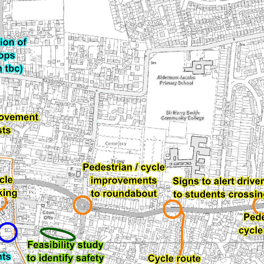
15 Issue to be addressed Improving access to hospital Improving walking and cycling facilities Action Lead by 16 Indicative m cost 17 /long term initial set up and five years pump priming Better publicise opportunities for accessing Peterborough City Hospital especially via the community car scheme and bus services. Investigate options that help address severance issues caused by the A605, particularly options suggested via consultation (see grey boxes below) and those which improve access to schools and any new development. Junction improvements for pedestrians and cyclists at junction of Hallcroft Road and West End, including urban realm improvements. Pedestrian/cycle improvements to A605 Roundabout at Broad Street/Orchard St/Whitmore Street. Pedestrian/cycle improvements to Cemetery Road/A605 Roundabout. Develop and produce walking/cycle map for Whittlesey. Improve facilities for pedestrians (including those who use scooters, pushchairs, wheelchairs etc). Specific schemes have been outlined below (see grey boxes below), but additional schemes may come forward and may include dropped kerbs, crossing facilities, signage, benches etc. A605 crossing between Belmans Road and Victory Avenue. Improve walking leisure routes including improvements and enhancements to the Hereward Way and Nene Way long distance paths and routes around the Brick Pits and Kings Dyke areas and to Coates. Types of measures include signposting, way-marking, gates, sections of surfacing, as well as events (eg health walks) and information relating to walking. Work with police to tackle issue of cars parking on pavements. Investigate options for providing other cycle infrastructure, for example new cycle routes Whittlesey and between Whittlesey, Coates and Eastrea. Specific schemes have been outlined below (see grey boxes below), but additional schemes may come forward and are likely to focus on the FDC, CCC, NHS, Community car scheme CCC, developers 500 Short See schemes outlined below, additional schemes may come forward at additional cost m /long 100,000 m 75,000 m 75,000 m CCC 5,000 Short CCC CCC, local stakeholder s See m schemes outlined below, additional schemes may come forward at additional cost 100,000 m 10,000 m CCC, Police - Short m /long 15
16 Issue to be addressed Addressing public transport issues bus services Action Lead by 16 Indicative m cost 17 /long term following: Improving routes to employment sites Making improvements to east-west travel in Whittlesey which allow cyclists (and pedestrians) to avoid the A605 Improving routes to schools Improving cycle leisure routes Improve the cycle route between the town centre and the station, using Marne Road, Hawthorne Drive, Millfield and Eastfield Drive. Improve cycle access to Park Lane school by improving cycle access over the junction of Hallcroft Road and West End. Improve cycle access to the McCains site (by connecting it to the NCN63) Carry out feasibility work to look at widening the footway next to the A605 for shared use and/or creating other cycle provision. Add cycle contraflow facilities on Horsegate Lane Crossing improvements at junction of Orchard Street/Gracious Street Provide cycle parking in key locations in Whittlesey, including at new developments (other potential locations include the town centre, the One Stop Shop) Improve cycle signage in Whittlesey Complete surfacing works on NCN63 (between Stonald Road and Millenium Bridge) to provide consistent, high standard surfacing. Investigate with local bus companies the possibility of rerouting some services to serve roads off the A605. Provision of a hopper bus linking key areas of the strategy area. Improve information, signs and timetables relating to public and community transport. Develop a press and publicity strategy for current public and community transport services, including raising awareness of the hail and ride services operating in Whittlesey. Investigate bus stop provision and/or improvements in the following locations highlighted through public consultation and outlined below (see grey boxes below). Additional schemes may also come forward. CCC 15,000 Short CCC See above m CCC 100,000 Medium/long CCC 5,000 m CCC 20,000 m CCC 25,000 m CCC, developers CCC, partners (eg Sustrans) 10,000 m 10,000 Short CCC 120,000 Short FDC, CCC, bus operators FDC, CCC developers FDC, CCC, partners FDC, CCC, bus operators, partners CCC, bus operators - m See above Short 10,000 m 5,000 m 2,000-20,000 per bus stop (dependin g on facilities required) 20,000 Provision of bus stop/improvements at Eastrea Road at east end of Whittlesey Provision of bus stop/improvements at 20,000 Short 16
17 Issue to be addressed Action Lead by 16 Indicative m cost 17 /long term Stonald Road if a service is provided Provision of raised kerb in Whittlesey s Market Square and/or reversal of one way system to allow existing raised kerb to be used. 20,000 Access to services outside Whittlesey Issue to be addressed Public transport buses Public transport - rail Action By whom Indicative cost Improving information about bus services and community transport and working with operators to review existing service routes and times. Investigate options for improved public and community transport, with a focus on links to Peterborough (particularly in the evenings), links to Eastrea and Coates, and links to and through new developments. Launch and develop the Fenland Community Rail Partnership. Develop a programme of events for Whittlesea Station and set up formal station adoption group. Improve facilities at Whittlesea Station (eg shelters, lighting, cycle parking, security, platform access). Ongoing programme of promotions and publicity relating to rail travel. Ongoing discussions with Department for Transport (DfT) and Train operating companies regarding improving service frequencies, and participation in relevant rail franchise consultations and discussions. Improve access, links and signage to Whittlesea Station. Provide bridge over the platforms at Whittlesea Station CCC, FDC, community transport operators, bus operators CCC, FDC, community transport operators, bus operators, developers CCC, FDC, Network Rail, Train Operating Companies CCC, FDC, Train Operating Companies CCC, FDC, Train Operating Companies CCC, FDC, Train Operating Companies FDC, CCC, DfT, Train Operating Companies. CCC, FDC, Network Rail, Train Operating Companies Network Rail, Train Operating Companies 5,000 for leaflets, marketing (including social media) and promotional material. Depends on options identified and on location/typ e of developmen ts. 3,000 Short 10,000 Short 20,000 Short m/long term m m/long 1,500 Medium - Short 3,000 signing and information Medium 350,000 Medium/Lon g 17
18 Issue to be addressed Action By whom Indicative cost m/long term Lengthen platforms at Whittlesea Station so longer trains can be accommodated. Network Rail, Train Operating 500,000 Long Explore proposals for a parkway station for Peterborough at Whittlesey Station (to include an extension to the car park). Companies CCC, FDC, Train Operating Companies 350,000 50,000 for the current car park. 300,000 for the extended car park. Long Economic, environmental and quality of life issues: Issue to be addressed Access to employment King s Dyke and other level crossings King s Dyke and other level crossings HCV traffic and conflicts between road users Levels of HCV traffic from new developments Town centre environment Road safety and health Action By whom Indicative cost Work with local employers to help people CCC, Travel access work and using walking, cycling and for Work public transport and encourage them to Partnership, work with the Travel for Work Partnership Local to implement Workplace Travel Plans. employers Ensure any new employment sites in and around Whittlesey have appropriate provision for sustainable transport. Support improvements to Broadband and wi-fi internet provision, as this can enable remote access to services. Initial study work relating to the feasibility of a scheme to improve the crossing at King s Dyke. Engage with Network Rail to investigate a possible funding package to improve the crossing at King s Dyke (and potentially other level crossings). Investigate replacement of Station Road level crossing manned barriers with automatic barriers. Improve signs directing HCV s to industrial areas and work with police to look at enforcement of the current HCV ban. Ensure new developments mitigate transport impacts on the network appropriately. Ensure new developments in the area contribute to retaining Whittlesey s character and sense of place. Investigate improvements which could be made to the Market Square in Whittlesey whilst retaining bus service provision in this area. Continue with the principles of the safer routes to schools projects. Some schemes identified by school working parties working with the CCC Road Safety Team have been identified, these are outlined below CCC, FDC CCC, FDC, developers CCC, FDC, Whittlesey Town Council CCC, FDC, Network Rail CCC, Police CCC, FDC CCC, FDC, developers CCC, FDC CCC m/long term - m Depends on developmen t. Part of CCC wider investment in Broadband. 10,000 Short 50,000 for feasibility study & at least 10 million for the bridge. 20,000 for signage Depends on developmen t. m/long m/long m/long m m/long - m/long Depends on options identified. Depends on schemes identified. Short m/long 18
19 Issue to be addressed Action By whom Indicative cost m/long term (see grey boxes). Additional schemes may come forward. Provision of cycle parking, parent waiting facilities, signage and railings at New Road Primary School. CCC 7,602 For cycle storage, parent waiting shelter, pedestrian guard railing, Short Investigate options to lower speed limit on the A605 and in other areas where this is supported by local residents and schools. Improve signage alerting drivers to vulnerable road users at key sites. Some sites mentioned in consultation are outlined below. Others may come forward. Stonald Road signs requested to alert drivers to elderly people Signs requested to alert drivers to students travelling to Sir Harry Smith Community College Investigate and safety and access improvements which can be made to the Eastgate area. Investigate options for providing Residential Travel Planning in new developments, in line with emerging draft Residential Travel Plan guidance being prepared by CCC in partnership with the District Council. Improve accessibility using active travel (eg walking and cycling) see section on improving walking and cycling facilities CCC, Town Council, local residents and schools CCC signage - m Depends on schemes identified. CCC 3,000 Short CCC 2,000 Short CCC 5,000 feasibility study CCC, FDC Depends on developmen t. See above section See above section m/long Short m/long See above section 19

20 Figure 5: Map showing the location of some of the action plan measures 18 Other actions: In addition to the actions outlined in the action plan above, the following will also be continued as part of the wider programme of work on Cambridgeshire s Third Local Transport Plan: Issue to be Action By whom Indicative addressed Traffic, congestion and HCV s Barriers to walking Road safety Continue to monitor traffic levels in and around Whittlesey. Improve pavement conditions and undertake routine pavement maintenance within the constraint of available budgets. Continue with routine maintenance of roads within the constraints of the budgets. CCC CCC CCC cost Part of CCC wider monitoring programme. Part of CCC maintenanc e programme Part of CCC maintenanc e programme 8 Delivery, monitoring and review of the strategy m/long term m m/long m/long Following the adoption of this strategy, progress on delivering the schemes set out in the action plan section will be monitored annually and reported on via Cambridgeshire County Council s website, see: As part of this annual monitoring process, the contents of the action plan will also be reviewed and updated if necessary. 18 See appendix for A4 version of this map. 20
21 Appendix 21
22 Whittlesey Market Town Transport Strategy Cabinet 27 November 2012 Appendix 21

:1:21000 Date:")


23 Whittlesey area schools and leisure facilities Scale (at A4):1:21000 Date: 19/09/2012 By: fp509 Crown copyright and database rights 2012 Ordnance Survey

24 Whittlesey 7.5 tonne Heavy Commercial Vehicle Ban Play Area Builder's Yard El Sub Sta Bowling Green El Sub Sta Car Park Car Park Car Park ESS Car Park Car Park Car Park Car Park Playground Tennis Courts Bowling Green Scale (at A4):1:3500 Crown copyright and database rights 2011 Ordnance Survey Date: 11/08/2011 By: fn267
25


26
Map showing location of public transport projects in vicinity of railway station
 Map showing location of public transport projects in vicinity of railway station Market Town Transport Strategy 2013 39 ID PT1a Specific Location Approach at Detail of Project Develop Area Master plan
DRAFT MARCH MARKET TOWN TRANSPORT STRATEGY 2013 INTRODUCTION
 DRAFT MARCH MARKET TOWN TRANSPORT STRATEGY 2013 INTRODUCTION This is the second Market Town Transport Strategy for March, replacing the strategy produced in 2002. It forms a part of the Third Cambridgeshire
Infrastructure for Growth
 A passion to deliver a prosperous future Connecting North Cambridgeshire Infrastructure for Growth Infrastructure for growth Wisbech is the largest settlement in Fenland. The town and its hinterland has
Report to: Greater Cambridge Partnership Joint Assembly 18 January A10 Foxton level crossing bypass and travel hub
 Report to: Greater Cambridge Partnership Joint Assembly 18 January 2018 Lead officer: Chris Tunstall GCP Director of Transport A10 Foxton level crossing bypass and travel hub 1. Purpose 1.1 The list of
Roundhouse Way Transport Interchange (Part of NATS City Centre Package)
") Roundhouse Way Transport Interchange (Part of NATS City Centre Package) 15/16 16/17 17/18 18/19 19/20 Total TOTAL COST Roundhouse Way Transport Interchange 0.5m 0.5m FUNDING CIL 0.05m 0.05m Growth Deal
Roundhouse Way Transport Interchange (Part of NATS City Centre Package) 15/16 16/17 17/18 18/19 19/20 Total TOTAL COST Roundhouse Way Transport Interchange 0.5m 0.5m FUNDING CIL 0.05m 0.05m Growth Deal
As part of our transport vision, Leeds City Council, working with the West Yorkshire Combined Authority and Leeds Bradford Airport Company, is
 As part of our transport vision, Leeds City Council, working with the West Yorkshire Combined Authority and Leeds Bradford Airport Company, is considering options for improving surface access and connectivity
Gold Coast. Rapid Transit. Chapter twelve Social impact. Chapter content
 Gold Coast Rapid Transit Chapter twelve Social impact Chapter content Social impact assessment process...235 Existing community profile...237 Consultation...238 Social impacts and mitigation strategies...239
Calderdale MBC. Wards Affected: Town. Economy and Investment Panel: 20 October Halifax Station Gateway Masterplan
 Calderdale MBC Wards Affected: Town Economy and Investment Panel: 20 October 2016 Halifax Station Gateway Masterplan Report of the Acting Director, Economy and Environment 1. Purpose of the Report 1.1
3. Coach Supporting Statement
 3. Coach Supporting Statement Content 1. Setting the Scene 2. Vision 3. Coaches and the Shared Priorities 4. Issues 5. Delivery Programme in the first Plan Period 2001/02 2005/06 6. Good Practice 7. Strategy
Proposed Lidl Food store West Hendford, Yeovil
 Proposed Lidl Food store West Hendford, Yeovil Lidl Travel Plan October 2015 CONTENTS Page 1.0 INTRODUCTION 1 1.1 Background 1 1.2 Aim of Travel Plan 1 1.3 Contents 2 2.0 TRANSPORT CONTEXT 3 2.1 Site Location
Schedule of Planning Applications Committee Date: 23 May Reference: 06/18/0064/F Great Yarmouth Officer: Mr J Beck Expiry Date:
 Schedule of Planning Applications Committee Date: 23 May 2018 Reference: 06/18/0064/F Great Yarmouth Officer: Mr J Beck Expiry Date: 24-04-2018 Applicant: Proposal: Site: Mr Mavroudis Clear weather hoardings
Llandudno Junction. Regeneration Proposals for the Future. December 2009
 Llandudno Junction Regeneration Proposals for the Future December 2009 Llandudno Junction - Vision Statement 1 Purpose 1.1 The purpose of this document is to describe key priorities to support the regeneration
Seek the Board s approval for the Donald Place kerb and channel renewal to progress to final design, tender and construction; and
 3. DONALD PLACE - KERB AND CHANNEL RENEWAL General Manager responsible: General Manager City Environment Officer responsible: Transport and City Streets Manager Author: Michelle Flanagan, Streets Capital
East Lancashire Highways and Transport Masterplan East Lancashire Rail Connectivity Study Conditional Output Statement (Appendix 'A' refers)
") Report to the Cabinet Member for Highways and Transport Report submitted by: Director of Corporate Commissioning Date: 1 June 2015 Part I Electoral Divisions affected: All East Lancashire Highways and
Report to the Cabinet Member for Highways and Transport Report submitted by: Director of Corporate Commissioning Date: 1 June 2015 Part I Electoral Divisions affected: All East Lancashire Highways and
Economic Development Sub- Committee
 Report title: Economic Development Sub- Committee Item No. Date of meeting: 24 November 2016 A47 Road Investment Strategy - update Responsible Chief Tom McCabe Executive Director, Community Officer: and
EAST SUFFOLK LINES. Stations Investment Plan. Produced by the East Suffolk Lines Community Rail Partnership
 EAST SUFFOLK LINES Stations Investment Plan Produced by the East Suffolk Lines Community Rail Partnership Updated February 2016 1. Introduction 1.1 This document (originally produced in 2010, updated in
Sainsburys Store, Mere Green Road, Sutton Coldfield, Birmingham, B75 5BT
 Committee Date: 7/0/013 Application Number: 013/04/PA Accepted: 1/04/013 Application Type: Variation of Condition Target Date: 1/07/013 Ward: Sutton Four Oaks Sainsburys Store, Mere Green Road, Sutton
Proposals for the Harrogate Road / New Line Junction Improvement Scheme. August / September Supported by:
 Proposals for the Harrogate / New Line Junction Improvement Scheme August / September 2016 Supported by: Introduction Key Benefits Proposals are currently being developed for changes to the junction of
Date 24/10/2011. Date 04/11/2011. Date 25/10/2011. Date 10/11/2011. Date 25/10/2011. Date 25/10/2011. Date 10/11/2011.
 DELEGATED POWERS REPORT NO. 1489 SUBJECT: Traffic Signal Review, Junction of Oakleigh Road North and the A1000 Control sheet All of the following actions MUST be completed at each stage of the process
OBJECTION TO AMENDMENT TO PLANNING SCHEME AND GRANTING OF PLANNING PERMIT
 PLANNING AND ENVIRONMENT ACT 1987 OBJECTION TO AMENDMENT TO PLANNING SCHEME AND GRANTING OF PLANNING PERMIT AMENDMENT C32 APPLICATION 0873/02 Public Transport Users Association Inc. 247-249 Flinders Lane
Old Limberlost Sports Club, Butlers Road, Handsworth Wood, Birmingham, B20 2NT
 Committee Date: 07/03/2013 Application Number: 2012/07986/PA Accepted: 29/11/2012 Application Type: Variation of Condition Target Date: 24/01/2013 Ward: Handsworth Wood Old Limberlost Sports Club, Butlers
South East Traffic Solution
 South East Traffic Solution A MAJORITY LIBERAL GOVERNMENT WILL: Complete the Hobart Airport Interchange project Fix the Tasman Highway near Tasmania Golf Club Replace the Midway Point Roundabout with additional
Appendix 6 Fulbourn Greenway Review
 Appendix 6 Fulbourn Greenway Review Nigel Brigham & Associates A report for 1 Introduction This report is based on fieldwork carried out in 2016 to review the Greenway network around Cambridge as shown
Port Macquarie-Hastings Pedestrian Access and Mobility Plan. Working Paper COMMUNITY ENGAGEMENT
 Port Macquarie-Hastings Pedestrian Access and Mobility Plan Working Paper COMMUNITY ENGAGEMENT December 2014 Table of Contents Table of Contents... 2 1 Introduction... 3 2 Submissions... 3 2.1 Stakeholder
JOINT CORE STRATEGY FOR BROADLAND, NORWICH AND SOUTH NORFOLK EXAMINATION MATTER 3C EASTON/COSTESSEY
 Matter 3C Easton/Costessey Representor No. 8826 JOINT CORE STRATEGY FOR BROADLAND, NORWICH AND SOUTH NORFOLK EXAMINATION MATTER 3C EASTON/COSTESSEY SUBMISSION ON BEHALF OF TAYLOR WIMPEY DEVELOPMENTS AND
LINCOLNSHIRE PARKING POLICY DRAFT
 LINCOLNSHIRE PARKING POLICY DRAFT Draft 23/05/11 1 of 7 1. Introduction This document sets out and explains the County Councils Parking Policy. The County Council is planning to apply for powers to take
SOUTH CAMBRIDGESHIRE DISTRICT COUNCIL. Executive Director / Senior Planning Policy Officer
 SOUTH CAMBRIDGESHIRE DISTRICT COUNCIL REPORT TO: Leader and Cabinet 8 May 2008 AUTHOR/S: Executive Director / Senior Planning Policy Officer SOUTH CAMBRIDGESHIRE DISTRICT COUNCIL S RESPONSE TO UTTLESFORD
EAST WEST RAIL EASTERN SECTION. prospectus for growth
 EAST WEST RAIL EASTERN SECTION prospectus for growth September 2018 executive summary The East West Rail Consortium, a partnership of local authorities, rail operators and Network Rail, continues to promote
Commissioning Director - Environment
 Finchley and Golders Green Area Committee 27 April 2017 Title Report of Wards Status Urgent Key Enclosures Summers Lane,N12 Request for Pedestrian Improvements Commissioning Director - Environment Woodhouse
Transport Delivery Committee
 Agenda Item No. 11 Transport Delivery Committee Date 6 th March 2016 Report title Accountable Director Accountable Employee Virgin Trains Partnership Agreement Update Pete Bond, Director of Transport Services
in Southwark: EXECUTIVE SUMMARY a survey and report
 Taxicard in Southwark: a survey and report 2002-2003 EXECUTIVE SUMMARY Taxi art displayed in a shopping centre Research into the London Borough of Southwark s Taxicard Scheme Alistair Beattie and Daniel
SALISBURY NHS FOUNDATION TRUST. Transport Strategy & Green Travel Update
 Paper: SFT 2035 SALISBURY NHS FOUNDATION TRUST Title: Transport Strategy & Green Travel Update Purpose of the Paper: To present an update on the Trust Transport Strategy and present a range of proposals
Agenda Item 5: Rail East Midlands Rail Franchise Consultation
 Strategic Transport Forum 15 th September 2017 Agenda Item 5: Rail East Midlands Rail Franchise Consultation Recommendation: It is recommended that the Forum agree (subject to any amendments agreed by
Guildford Borough Transport Strategy 2017, Topic Paper: Transport, June 2017 (accompanying Local Plan 2017) Local Plan Transport Strategy 2017
 Local Plan Transport Strategy 2017") Guildford Society Transport Group Position Paper August 2017 Based on submissions in response to the June/July 2017 Local Plan consultation including material presented to Drop-in Session 15 July 2017.
Guildford Society Transport Group Position Paper August 2017 Based on submissions in response to the June/July 2017 Local Plan consultation including material presented to Drop-in Session 15 July 2017.
ASLEF s Response to the East Anglia Rail Franchise Consultation
 ASLEF s Response to the East Anglia Rail Franchise Consultation 1. The Associated Society of Locomotive Engineers and Firemen (ASLEF) is the UK s largest train driver s union representing approximately
WELSH GOVERNMENT RESPONSE P Ensure Disabled People can Access Public Transport As and When They Need it
 WELSH GOVERNMENT RESPONSE P-05-710 Ensure Disabled People can Access Public Transport As and When They Need it The petition submitted by Whizz Kidz seeking action to ensure that disabled people can access
STAG - Part 1 Appraisal Summary Table
 Proposal Details Proposal Name: Option 1 - Do-minimum Proposal Description: This assumes that the Council only carry out the statutory requirements under the Roads (Scotland) Act 1984. This would include
Gold Coast. Rapid Transit. Chapter content. Chapter four Route selection and staging
 Chapter four Route selection and staging Gold Coast Rapid Transit Chapter four Route selection and staging Chapter content Route selection...73 Section one: Helensvale to Griffith University...74 Section
Team London Bridge Response to the Department for Transport Consultation on the combined Thameslink, Southern and Great Northern franchise
 Team London Bridge Response to the Department for Transport Consultation on the combined Thameslink, Southern and Great Northern franchise 23 August 2012 Table of Contents 1. Executive Summary 2. Introduction
Saighton Camp, Chester. Technical Note: Impact of Boughton Heath S278 Works upon the operation of the Local Highway Network
 Technical Note: Impact of Boughton Heath S278 Works July 2013 SAIGHTON CAMP CHESTER COMMERCIAL ESTATES GROUP TECHNICAL NOTE: IMPACT OF BOUGHTON HEATH S278 WORKS UPON THE OPERATION OF THE LOCAL HIGHWAY
WELLINGTON $422 MILLION $614 MILLION $83 MILLION 22% SPEND $1.9 BILLION
 WELLINGTON WELLINGTON $1.9 BILLION FORECAST TOTAL WELLINGTON INVESTMENT The Wellington region s transport challenges are dominated by the region s concentration of population in the metropolitan cities,
Better Towpaths for Everyone. A national policy for sharing towpaths
 Better Towpaths for Everyone A national policy for sharing towpaths Contents Foreword 2 Introduction 3 Consultation 3 Principles of towpath use 4 Better infrastructure 5 Towpath Design Guide 5 Better signs
Committee. Presentation Outline
 CW-33-15 11/9/2015 Community and Corporate Services Committee November 10, 2015 1 Presentation Outline Background Vision and Objectives Study Process and Timeline Public and Stakeholder Engagement Organization
5 Rail demand in Western Sydney
 5 Rail demand in Western Sydney About this chapter To better understand where new or enhanced rail services are needed, this chapter presents an overview of the existing and future demand on the rail network
Active Travel Strategy for Perth and Kinross
 Appendix 1 Active Travel Strategy for Perth and Kinross 1. Background The Active Travel Strategy for Perth and Kinross has been developed to encourage, enhance and monitor physical active travel modes
Draft Western District Plan
 Powered by TCPDF (www.tcpdf.org) Draft Western District Plan Submission_id: 31732 Date of Lodgment: 15 Dec 2017 Origin of Submission: Online Organisation name: APP Corporation Pty Ltd Organisation type:
N4 Carrick-on-Shannon to Dromod Road Project. 2.1 Introduction
 Chapter 2 Need for the Scheme 2.1 Introduction The National Primary Route N4, Dublin to Sligo is a strategic corridor from Dublin to the northwest and border counties (See RCSR 101 in Volume 2). The National
Cabinet. The Future of Wareham Foot Level Crossing. Date of Meeting 24 February 2016
 Page 1 The Future of Wareham Foot Level Crossing Cabinet Date of Meeting 24 February 2016 Cabinet Member(s) Peter Finney Cabinet Member for Environment Colin Jamieson - Cabinet Member for Economy and Growth
Wellington $312 $49 $456 OVERVIEW WELLINGTON REGIONAL SUMMARY
 National Land Transport Programme 2015 18 Wellington WELLINGTON REGIONAL SUMMARY OVERVIEW The Wellington region is made up of a number of cities, urban areas and supporting rural hinterland. The city is
Member-led Review of Cycling Infrastructure
 Member-led Review of Cycling Infrastructure Survey Results: Hills Road, Cambridge June 2017 0 cambridgeshire.gov.uk Contents 1. Introduction... 3 2. About you... 3 2.1 Age... 3 2.2 What is your gender?...
Response to the London Heathrow Airport Expansion Public Consultation
 Response to the London Heathrow Airport Expansion Public Consultation Summary This report sets out the response to the Heathrow Airport s consultation on airport expansion and airspace change. The consultation
Review of Highcliffe Shopping Centre
 Review of Highcliffe Shopping Centre A Summary M W Mawbey 15 th December 2013 INTRODUCTION Concern for the health of high streets is common theme across the country. High streets have been affected by
Board meeting
 Board meeting 28.11.17 Secretariat memorandum Author: Vincent Stops Agenda item: 8 Ref: LTW568 Drafted: 13.11.17 Oxford Street bus changes associated with pedestrianisation 1 Purpose of report 1.1. To
Chapter 6 Route Window NE5 Seven Kings station. Transport for London
 Chapter 6 Route Window NE5 Seven Kings station Transport SEVEN KINGS STATION 6 Route Window NE5 Seven Kings Station Transport Introduction 6.1 All construction activities in this route window are associated
PERTH-ADELAIDE CORRIDOR STRATEGY
 INTRODUCTION The Royal Automobile Association of SA Inc (RAA), the State s principal advocate for motorists on a broad range of motoring-related issues, represents the views of more than 560,000 South
IOW Ramblers Submission Paper to the Sept 2016 ROW Improvement Plan Consultation.
 IOW Ramblers Submission Paper to the Sept 2016 ROW Improvement Plan Consultation. The current Island Rights of Way Improvement Plan is a comprehensive document and much of its content is still relevant
WELCOME WELCOME TO OUR PUBLIC EXHIBITION FOR THE BOND STREET PUBLIC REALM PROJECT.
 WELCOME WELCOME TO OUR PUBLIC EXHIBITION FOR THE BOND STREET PUBLIC REALM PROJECT. Bond Street Development Plan is one of the key initiatives outlined in the West End Partnership s vision. Bond Street
Traffic calming on major roads: a traffic calming scheme at Costessey, Norfolk
 Traffic Advisory Leaflet 14/99 December 1999 Traffic calming on major roads: a traffic calming scheme at Costessey, Norfolk Introduction This leaflet summarises the impact of a traffic calming scheme on
TRANSPORT FOR GREATER MANCHESTER COMMITTEE REPORT FOR RESOLUTION
 TRANSPORT FOR GREATER MANCHESTER COMMITTEE REPORT FOR RESOLUTION DATE: 11 November 2011 SUBJECT: REPORT OF: Proposed making of a Quality Partnership Scheme for the A6 corridor between Manchester and Hazel
Consultation on Draft Airports National Policy Statement: new runway capacity and infrastructure at airports in the South East of England
 Tony Kershaw Honorary Secretary County Hall Chichester West Sussex PO19 1RQ Telephone 033022 22543 Website: www.gatcom.org.uk If calling ask for Mrs. Paula Street e-mail: secretary@gatcom.org.uk 22 May
Update on implementation of Taking Revalidation Forward recommendations
 Agenda item: 7 Report title: Report by: Action: Update on implementation of Taking Revalidation Forward recommendations Judith Chrystie, Assistant Director, Registration and Revalidation Judith.Chrystie@gmc-uk.org,
Haworth Tr T avel Plan r 10th February 2006
 Haworth Travel Plan 10th February 2006 Haworth Travel Plan has been prepared for: Contents 1 Why have Haworth Travel Plan?... 3 2 Who will benefit from Haworth Travel Plan?... 4 3 What actions will be
Riverside Heights, Norwich. Travel Plan
 RIVERSIDE HEIGHTS, NORWICH Client: Engineer: Taylor Wimpey East Anglia Create Consulting Engineers Limited Hungate House Princes Street Norwich Norfolk NR3 1AZ Tel: 08454507908 Email: enquiries@createconsultingengineers.co.uk
Arrangements for the delivery of minor highway maintenance services by Town and Parish Councils
 Arrangements for the delivery of minor highway maintenance services by Town and Parish Councils Cabinet Date of Meeting 8 March 2017 Officer Cllr Peter Finney, Cabinet Member for Environment, Infrastructure
Scotchbarn Lane, Prescot Accessibility Statement
 Scotchbarn Lane, Prescot Accessibility Statement Lancashire Mortgage Corporation Ltd August 2012 Issue R001B 9X0789 All rights reserved. No part of this publication may be reproduced in any form, including
The case for a local rail station. At Great Blakenham, Suffolk.
 The case for a local rail station At Great Blakenham, Suffolk. The London to Norwich (Great Eastern) main rail line passes through Great Blakenham in Suffolk, a village which adjoins Claydon and Barham.
BARNSLEY METROPOLITAN BOROUGH COUNCIL
 BARNSLEY METROPOLITAN BOROUGH COUNCIL This matter is a Key Decision within the Council s definition and has been included in the relevant Forward Plan REPORT OF THE EXECUTIVE DIRECTOR OF PLACE TO CABINET
East Midlands Rail Franchise Public Consultation
 Scarborough Leeds York Manchester Liverpool Doncaster Sheffield Barton-on -Humber Crewe Chesterfield Matlock Worksop Lincoln Mansfield Grimsby Cleethorpes Skegness Stoke-on-Trent Derby ottingham Grantham
Q: How many flights arrived and departed in 2017? A: In 2017 the airport saw 39,300 air transport movements.
 Southampton Airport Masterplan FAQ 4 October 2018 Background Southampton Airport Today Q: How many passengers currently use Southampton Airport and how has this changed over the last 5 years? A: Over the
Regulatory Committee
 Page 1 - Proposed Turning Movement Bans at South Gate Junction, Dorchester Regulatory Committee Date of Meeting 16 March 2017 Officer Subject of Report Executive Summary Andrew Martin Service Director
South of England north-south connectivity
 South of England north-south connectivity An outline economic case for the inclusion of north-south connectivity improvements to form part of the government s road investment strategy (RIS2) Weston-super-Mare
Train Stations are not just arrival and departure locations
 Train Stations are not just arrival and departure locations The Railway Study Association Mike Goggin 31 October 2017 Contents Introduction to Steer Davies Gleave The Passenger The Neighbour & Non-Traveller
LINCOLNSHIRE PARKING POLICY DRAFT
 LINCOLNSHIRE PARKING POLICY DRAFT Draft 17/11/11 1 of 7 1. Introduction This document sets out and explains the County Councils Parking Policy. The County Council is planning to apply for powers to take
King s Dyke Level Crossing Replacement - Initial Investigation
 King s Dyke Level Crossing Replacement - Initial Investigation Cambridgeshire County Council 7 th June 2013 Notice This document and its contents have been prepared and are intended solely for Cambridgeshire
Perth and Kinross Council Development Management Committee 20 February 2013 Report of Handling by Development Quality Manager
 Perth and Kinross Council Development Management Committee 20 February 2013 Report of Handling by Development Quality Manager 4(4)(ii) 13/80 Replacement and re-positioning of street furniture, The Birks,
A140 study and Major Road Network
 A140 study and Major Road Network Executive Summary The Government s new Transport Investment Strategy sets out a new long-term approach for government infrastructure spending. Funding will be targeted
OUTLINE RESPONSE FROM WELWYN PLANNING & AMENITYGROUP (WPAG) TO CONSULTATION OVER PROPOSED EXPANSION OF LUTON AIRPORT
 TO CONSULTATION OVER PROPOSED EXPANSION OF LUTON AIRPORT") OUTLINE RESPONSE FROM WELWYN PLANNING & AMENITYGROUP (WPAG) TO CONSULTATION OVER PROPOSED EPANSION OF LUTON AIRPORT This draft follows the format of the supplied response booklet. The contents have been
OUTLINE RESPONSE FROM WELWYN PLANNING & AMENITYGROUP (WPAG) TO CONSULTATION OVER PROPOSED EPANSION OF LUTON AIRPORT This draft follows the format of the supplied response booklet. The contents have been
This report is PUBLIC [NOT PROTECTIVELY MARKED] Board Meeting. Councillor Roger Lawrence Transport
![This report is PUBLIC [NOT PROTECTIVELY MARKED] Board Meeting. Councillor Roger Lawrence Transport](/thumbs/85/92100595.jpg "This report is PUBLIC [NOT PROTECTIVELY MARKED] Board Meeting. Councillor Roger Lawrence Transport") Agenda Item No. 5.4 Board Meeting Date 17 February 2017 Report title Cabinet Member Portfolio Lead Accountable Managing Director Accountable Employee Report has been considered by West Midlands Bus Alliance
Agenda Item No. 5.4 Board Meeting Date 17 February 2017 Report title Cabinet Member Portfolio Lead Accountable Managing Director Accountable Employee Report has been considered by West Midlands Bus Alliance
PLANNING STATEMENT FORMER HSBC BANK, 18 HIGH STREET, AMESBURY
 PLANNING STATEMENT FORMER HSBC BANK, 18 HIGH STREET, AMESBURY 21 Dec 17 Introduction Amesbury has a vibrant nightlife with three public houses, two hotel bars and a nightclub within the town centre as
2.2 For these reasons the provision of tourist signing will only be considered:
 TOURIST SIGNING POLICY 2015 1. DEFINITION 1.1 A tourist destination is defined as a permanently established attraction which attracts or is used by visitors to an area and is open to the public without
Felixstowe Branch Line FAQ
 Felixstowe Branch Line FAQ How was the location of the track doubling work decided? We undertook a study to identify how to meet the freight demand along the Felixstowe Branch Line by modelling the route.
West London Economic Prosperity Board. 21 March Summary. Title Orbital Rail in West London
 West London Economic Prosperity Board 21 March 2017 Title Orbital Rail in West London Report of Status Urgent Enclosures Officer Contact Details Amar Dave (LB Brent) Public No Appendix 1: Specification
Investing in Greater Manchester transport 2017/2018
 TRAFFIC Investing in Greater Manchester transport 2017/2018 INFORMATION www.greatermanchester-ca.gov.uk Transport is an important part of life for residents and businesses in Greater Manchester. It connects
Borders Railway - Scottish Borders Work Plan
 Borders Railway - Scottish Borders Work Plan March 2015 This Scottish Borders Work Plan sets out the short, medium and longer term actions that the Council and other local partners need to take to ensure
Submission to. Southland District Council on. Draft Stewart Island/Rakiura Visitor Levy Policy and Bylaw
 Submission to Southland District Council on Draft Stewart Island/Rakiura Visitor Levy Policy and Bylaw Date: 9 November 2018 Tourism Industry Aotearoa (TIA) welcomes the opportunity to comment on Southland
Open Report on behalf of Richard Wills, Executive Director for Environment and Economy
 Agenda Item 7 Executive Open Report on behalf of Richard Wills, Executive Director for Environment and Economy Report to: Executive Date: 02 September 2014 Subject: Lincoln East West Link Road Phase 1
Item 1. Leadership Board. On: 1 April Report by: Director of Development and Housing Services. Heading: Update on City Deal. 1.
 Item 1 To: Leadership Board On: 1 April 2015 Report by: Director of Development and Housing Services Heading: Update on City Deal 1. Summary 1.1 This report seeks to update the Board on the work that has
Environment Committee 24 September 2015
 Environment Committee 24 September 2015 Title Enforcement of Single Yellow Lines on Bank Holidays Report of Commissioning Director - Environment Wards All Status Public Urgent No Enclosures Key No Appendix
Integration of Pedestrian Traffic Signal Control within SCOOT-UTC Systems
 Traffic Advisory Leaflet 2/09 April 2009 Integration of Pedestrian Traffic Signal Control within SCOOT-UTC Systems Introduction SCOOT 1,2,3 (Split Cycle and Offset Optimisation Technique) is an adaptive
A Response to: Belfast On The Move Transport Masterplan for Belfast City Centre, Sustainable Transport Enabling Measures
 West Belfast Partnership 218-226 Falls Road Belfast BT12 6AH T: 02890809202 A Response to: Belfast On The Move Transport Masterplan for Belfast City Centre, Sustainable Transport Enabling Measures Issued
Date: 11 th January, From: Plaistow & Ifold Parish Neighbourhood Plan - Steering Group. Plaistow & Ifold Parish Council
 Date: 11 th January, 2017 From: Plaistow & Ifold Parish Neighbourhood Plan - Steering Group To: Plaistow & Ifold Parish Council Re: Neighbourhood Plan Report to Parish Council Meeting 17 Jan 2017 The Steering
3.0 LEARNING FROM CHATHAM-KENT S CITIZENS
 3.0 LEARNING FROM CHATHAM-KENT S CITIZENS An important aspect in developing the Chatham-Kent Trails Master Plan was to obtain input from stakeholders and the general public. Throughout the course of the
Proposed Housing Developments In Great Horkesley
 Proposed Housing Developments In Great Horkesley Introduction Colchester Borough Council is producing a plan the purpose of which is to guide development in the Borough through to the year 2033. The Local
Your Transport Levy Your Transport Future. Sunshine Coast Council Transport Levy Annual Report
 Your Transport Levy Your Transport Future Sunshine Coast Council Transport Levy Annual Report 2016-2017 www.sunshinecoast.qld.gov.au T 07 5475 7272 F 07 5475 7277 Locked Bag 72 Sunshine Coast Mail Centre
Public Realm & Landscape
 Town Centre Context Public Realm & Landscape 1. Public realm in the Town Centre varies significantly in quality. Areas of particularly good quality public realm are located around the Minster and outside
Kilometres. Blacktown. Penrith. Parramatta. Liverpool Bankstown. Campbelltown
 0 5 10 15 20 Kilometres Penrith Blacktown Parramatta Liverpool Bankstown Campbelltown accessibility outcomes Legend Outcomes targeted in Western Sydney are: public transport that is accessible throughout
cornwall rural community council : community-led planning database
 cornwall rural community council : community-led planning database No of Actions for Each Rural Theme - by District: Access to health care Lack of transport/access to hospitals, GP surgeries, NHS dentists,
Clyde Waterfront and Renfrew Riverside Project Glasgow Airport Investment Area Project
 Item 1 To: Leadership Board On: 3 June 2015 Report by: Director of Development and Housing Services Heading: City Deal Strategic Business Cases 1. Summary 1.1 This report seeks approval from the Board
Welcome. Great Yarmouth Third River Crossing. Norfolk County Council
 Welcome Great Yarmouth Third River Crossing We are proposing to build a new bridge between Harfreys Roundabout and South Denes Road, and we would like your views. This consultation is stage two of a three-stage
7. CONSULTATION ON THE TRAVELLER SITES ALLOCATIONS DOCUMENT
 7. CONSULTATION ON THE TRAVELLER SITES ALLOCATIONS DOCUMENT REPORT OF: HEAD OF ECONOMIC PROMOTION AND PLANNING Contact Officer: Nathan Spilsted, Senior Planning Officer Email: nathan.splistead@midsussex.gov.uk