* " 2013% Aldbourne"Traffic"Plan" Aldbourne*Traffic*Plan* Aldbourne*Parish*Council* 3/24/2013* Aldbourne*Traffic*Plan*
|
|
|
- Liliana Doyle
- 5 years ago
- Views:
Transcription

1 * * " 2013% Aldbourne"Traffic"Plan" Aldbourne*Traffic*Plan* Aldbourne*Parish*Council* Aldbourne*Traffic*Plan* * 3/24/2013* 1"

2 Introduction Aldbourne is taking part in the Marlborough Area Board traffic initiative. This provides support and resources to Parish Councils to address issues relating to traffic, movement and village quality. With the support of Wiltshire Council, it aims to help participating parish councils to agree principles and priorities, and prepare plans for local actions as well as future County Council highway priorities. This Traffic Plan has been prepared by the Traffic Working Party, with support from HamiltonIBaillie Associates, on behalf of Aldbourne Parish Council. It aims to describe the key concerns of the residents, and propose solutions, both short and long term, for action both locally and by Wiltshire Council. It is intended to provide guidance for any future investment and maintenance programmes, as well as any future development proposals. Notes: 1. References to the Community Plan are to the Aldbourne Community Plan published in Autumn During the development of the plan, every household in the village received a questionnaire to record residents views on a variety of matters, including traffic. 2. Throughout the text, Post Office crossroads refers to the junction of the B4192 with Marlborough RoadandCastleSt. 3. Traffic Working Party members: Diane Powell, Neil Howard, Keith Warren and Michael Cowan. Acknowledgements: Maps: Crowncopyrightanddatabaserights(2011)OrdnanceSurvey( ) Aerial pictures: GetmappingPLC Photos: Diane Powell Aldbourne Traffic Plan 2

3 Aldbourne Village Aldbourne lies in a triangle between Marlborough, Swindon and Hungerford, and is within the North Wessex Downs Area of Outstanding Natural Beauty. It is a very picturesque village, much of which is designated a Conservation Area, and contains over 80 listed buildings. Many features of historical interest or significance remain today, including two village pumps and the Market Cross. It is a growing village: the population has increased by 12% in the last ten years and is now over 2000, living in approximately 800 dwellings. The village is situated on the B4192, which is the main route between Swindon and Hungerford In addition to the B4192 entering and exiting the village (on West Street and South Street) there are five further vehicular routes leading into the village. These roads all converge on The Square which lies at the heart of the village. The Square, with its duck pond and The Crown pub, is one of the key spaces in the village, together with The Green which is overlooked by both St Michael s church and The Blue Boar pub. The village has two churches, a library, a primary school, two preischools, two pubs, a Sports & Social Club and the Memorial Hall. In addition several businesses are located in the village including the Post Office Store and Café, the CoIop, two garages, a hairdresser, takeaway, and numerous small businesses such as pet care, taxi service, home decorators, child care, garden design, various therapists, and small builders. The village has its own website and a magazine, the Dabchick, which is published bimonthly. GetmappingPLC Therearenumerousclubsandsocietiesactiveinthevillage;theDecember2011Dabchickmagazine included a list of over 60 different groups as diverse as WI, Tennis Club, Beavers, Cubs and Scouts, Silver Threads, ALEC (Light Entertainment), Children s Book Group, Gardening Club. The Aldbourne Band (established in 1835) competes very successfully in national competitions and performs several concerts a year in the village, including the Pond Concerts, Proms on the Green in August and the Christmas Carol Concert. Recently a Youth Training band has been formed and performed its first concert. All of this contributes to a very strong sense of community, as demonstrated by enthusiastic support forregulareventssuchasthecarnival,churchfete,communitymarkets,aldbourneshow, Band concerts, Beating the Bounds and, this year, the Jubilee celebration events. Aldbourne receives many visitors: it is often visited by people interested in the 101 st Airborne division, one of whose units (Easy Company) was based here during WWII and was the subject of the TV series Band of Brothers. An episode of Dr Who was also filmed here. There are numerous good walks in and around the village, one of which (thealdbournecircularroute)oftenfeaturesinwalkingpublications. In summary, Aldbourne is a vibrant village, with many well used facilities, thriving businesses and a strong sense of community. Aldbourne Traffic Plan 3
4 Policy Context In 2011 the Aldbourne Community Plan surveyed residents view on a number of matters affecting the village. The survey found that traffic in the village, more specifically speeding and parking issues, was one of the residents greatest concerns. As a result Aldbourne Parish Council resolved to take action to try to improve pedestrian safety by reducing speeding and dangerous parking in the village. On a national level the Localism Bill aims to give local communities more power to influence local events. This is particularly significant at a time when cuts in government spending limit the scope for conventional Highways solutions to traffic problems. Manual for Streets 2 (published by the Chartered Institution of Highways and Transportation in September 2010) emphasises that streets should be places in which people want to live and spend time in, and are not just transport corridors. In particular, the manual aims to reduce the impact of vehicles on residential streets by asking practitioners to plan street design intelligently and proactively, and gives a high priority to the needs of pedestrians, cyclists and users of public transport. Following on from this the Marlborough Area Board has been exploring new possibilities in the management and maintenance of rural communities hence this Traffic initiative. Other counties such as Dorset, Hampshire and Kent are also exploring fresh approaches to rural highway design, with publications such as Traffic in Villages: a Toolkit for Communities by Dorset AONB outlining new ways to create safe lowicost environments. Design Principles This Traffic Plan aims to address several concerns but there are two underlying principles: firstly to promote safety of pedestrians and drivers in the village by reducing speeds and increasing driver awareness of their environment; and secondly to prevent the spread of urbanisation in the village by enhancing the key spaces, addressing parking congestion and reducing street clutter. Gateways and Entry Points There are seven roads providing entry to the village. Currently these entrances are marked with an Aldbourne sign and a 30mph sign. White gates acquired some time ago have recently been installed at the entry points in West St and Oxford St. Traffic is routinely observed travelling into the village at speeds in excess of 30mph on all of these roads but the Community Plan survey showed that the B4192 (West St and South St) and Oxford St are the ones where pedestrians are considered most at risk and vehicle accidents are thought more likely. Key Areas The Square The Square, together with The Green (see later), lies at the heart of the village and the Conservation Area, and many of the most historical features and village characteristics can be found here. The duck pond is here, so too the Crown pub, which dates back to the early 18 th century along with other buildings such as Ivy House. The library, the village noticeboard and the Old Forge (recently reiopened) are also to be found here. As such villagers are often seen stopping to chat as they pass backwards and forwards in their daily routines. Aldbourne Traffic Plan 4
5 The Green The Green also lies at the centre of the conservation area, and is overlooked by St Michael s church and the Blue Boar pub. Residential buildings, mostly listed because of historical interest (many of them can trace their origins back to the 1700s), lie on all four sides. It is widely regarded as Aldbourne s finest feature and is the setting for many village events such as the fete and church services, Band Proms concert, Community Markets, the Easter Eggstravaganza and the Carnival and Feast fairs, to name a few. Generally speaking there are few concerns about The Green from a traffic perspective although inconsiderate parking at the top end sometimes makes access difficult. The Parish Council has been in prolonged correspondence with Wiltshire Council about completing the line of setts which edge the Green to date a suitable product has not been found. The Square, however, is of concern for many reasons, as described later. Key Concerns General The village is situated on the B4192 which is the main route between Swindon and Hungerford. It is also the diversion route used to redirect traffic whenever the M4 is closed between J14 and J15. Satellite navigation systems also highlight this optional nonimotorway route. In addition to the B4192 entering and exiting the village (on West Street and South Street) there are five further vehicular routes leading into the village: Marlborough Road, Ewens Hill, Castle Street, Lottage Road and Oxford Street. Thus a total of seven roads all converge in the centre of the village, leading to a high volume of traffic at all times of the day and week. The public bus service provides transport to Swindon, Marlborough and Hungerford, but the majority of residents usecarsorvansforregularjourneystowork,trainingorstudy.lessthan20%ofcommunity Plan survey respondents regularly use bus services (generally because frequency and times of services do not match the demand). This again contributes to the volume of private vehicle movement through and within the village. New building work (most recently Valley View and Barnes Yard) has periodically contributed to the increase in both number of dwellings and population. This in turn leads to an increase in the number of vehicles in the village. The B4192 bisects the village, with approximately half of the dwellings lying to the north and half to the south. The shops, public houses, school, library, churches and halls, which are central to the way of life, are all situated in the heart of the village, with the majority north of the B4192. However, one very important, and frequently used, facility, the Post Office Store and Café, is to the south of this main road. Recreational facilities at the tennis club, football field and Palmers Field also lie south of the main road. This layout means that there is a considerable amount of pedestrian traffic crossing this very busy road at all times of the day and every day of the week. The road bends on entering and leaving thissection meaning that there is no single stretch providing good visibility for safe crossing. There is no zebra or pelican crossing, simply a red strip of tarmac showing the least dangerous place to cross. This red strip has now become very dilapidated following building development in Barnes Yard, next door to the Post Office. We have monitored actual pedestrian crossing lines and only about 50% of people who cross Aldbourne Traffic Plan 5
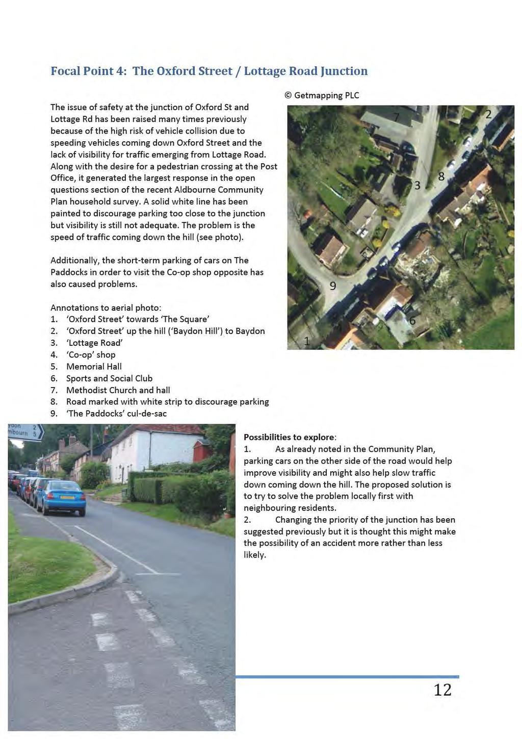
6 actually take the route marked by the red strip. This suggests that simply replacing the redstripmaynot be the most effective course of action for this area. Elsewhere on the B4192, for pedestrians entering the village from the south there is a pavement on the west side of the road but this stops at Glebe Close, forcing pedestrians to either continue on the road or to cross at a point of limited visibility in order to continue on pavement. Entering the village from the west, there is pavement on one side only, again forcing pedestrians who live on the other side to either walk on the road or to cross at a point of limited visibility. Speeding For many years villagers have expressed concern about the number of vehicles travelling at speed through the village, and the subject has been discussed at numerous Parish Council meetings. One villager went so far as to acquire, at his own expense, a Speed Indicator Device (SID) and collated data for many months until he was obliged to remove it. His data showed a significant number of vehicles travelling at speeds in excess of 30, 40 and 50mph at several different locations in the village. In April 2012 a Metrocount survey was carried out in South St and the data showed that the 85 th percentile was 39.1mph (the 85 th percentile is the speed at which 85% of the traffic is travelling at or below). This meant that this location became eligible for the rota to receive visits by the official SID. Speeding is actually of even greater concern to villagers in two different areas: the Post Office crossroads (because of risk to pedestrian safety); and Oxford Street,approachingthejunctionwithLottageRoad (because of risk of vehicle collision). Parking There has been a steady increase in the number of vehicles parking in the village during the day for owners to use facilities such as the CoIop, Post Office and other businesses, and during the evening / overnight by residents. Many households now have more cars than parking spaces and the streets and key spaces are becoming quite congested. A particular problem area during the day is the Post Office crossroads, where vehicles park on three of the four corners (sometime all four corners) creating visibility problems for vehicles turning into and out of Marlborough Road / Castle Street,andrestricting visibility for pedestrians trying to reach or leave the shops or recreational facilities on the other side. Parking at the lower end of Oxford Street (west side) is a problem during the day and night because it restricts visibility for vehicles emerging from Lottage Road. Cars speeding down Oxford Street towards this junction exacerbate the problem. See photo on p12. Next Steps The following pages describe several options for improvements which could address the speeding or parking problems identified above. These should now be given further consideration and wider consultation with stakeholders and other interested parties todeterminewhichwouldbethemost effective. Aldbourne Traffic Plan 6

7 Focal Point 1: The Post Office Crossroads Post Office Crossroads as previously mentioned this area is of great concern due to the high risk of pedestrian accident or vehicle collision Annotations to aerial photo: 1. West Street 2. Barnes Yard new housing development 3. Community Junction community youth centre and shop 4. Post Office Café and Deli shop 5. Marlborough Road 6. Castle Street 7. Dabchick s Delight Indian takeaway 8. CutIthrough towards The Crown public house 9. The Square leading Eastwards to South Street The Square House private residence 11. Toad Hall private residence 12. Access to Barnes Yard from West Street / The Square 13. Red strip across road, now badly damaged by construction work at Barnes Yard Options to explore: GetmappingPLC 1. Bar vehicular traffic from using the cutithrough (8) that runs from the B4192 into The Square towards The Crown. This would: (i) reduce the crossroads effect outside the Post office; (ii) improve pedestrian safety in The Square by removing fast moving vehicles using The Square as short cut; (iii) enhance The Square area generally. 2. Bar vehicular traffic from using the alley that runs from the B4192 into The Square between the Old Bakehouse and Community Junction. This would improve pedestrian safety in The Square by removing fast moving vehicles using The Square as short cut and enhance The Square area generally. The figures below show some other possibilities and use the following colouricoding: Light grey: tarmac road. Dark grey: tarmac of different colour, used for parking. Red stripe: preferred crossing indication (now severely worn). Light blue: raised pavement for pedestrians. Lavender: unraised zone for pedestrians. Brown: buildings. Green: private unbuilt fencedioff areas. Aldbourne Traffic Plan 7
 mark the boundary of this area. This proposal allows us to experiment with various parking arrangements on the North or the South side of the Eastwards road. 4.")
8 Other possibilities to explore: The figure on the right shows the current usage. Some ideas for alternatives are given below. 3. Creating a junction area that has no road markings. See figure below. Stripesacrosstheroad (lavender) mark the boundary of this area. This proposal allows us to experiment with various parking arrangements on the North or the South side of the Eastwards road. 4. Create a Piazza (!). The junction area becomes avillagefeaturewith, perhaps, an outdoor tablei tennis table outside the Community Junction and chairs and tables either directly outside the Post Office or outside 12 The Square, for the Post Office Café. 5. Changing the priority of traffic by creating atijunction. Priority from West Street (B4192) to Marlborough Road and vice versa. Give way from The Square (South Street) to West Street (B4192). Prior example of give way on the same road number: The Hare junction at Lambourn (B4000). Junction would actually be a staggered crossiroads (with Barnes Yard being the fourth road). 6. Distinctive surface where four ways meet. This suggests an area for pedestrians to cross. 7. Place a distinctive feature where four ways meet. 8. Put a kink in South Street. Traffic runs straight past Dabchick s Delight. This then allows parking in front of Toad Hall and the other houses on that side of the road. The junction of the four roads is then a normal 4Iway junction instead of being staggered. This changes the need for pedestrians to cross diagonally across the road into an easy crossing across Marlborough Road and a more difficult crossing in front of traffic giving way from South Street (which is easier to cross because the traffic already has to stop there to give way). 9. As directly above but with a fouriway giveiway at Barnes Yard / West Street / South Street / Marlborough Road. This is shown on the right. Aldbourne Traffic Plan 8


9 Focal Point 2: The Square and Library This section relates to the area between The Crown and the library,incorporatingthepond. Once a central meeting point, now however, the Square is an amorphous sprawl of tarmac which is mostly used as a short cut and a car park. The duck pond is virtually barricaded off by parked cars meaning acorepartofthevillage snaturalcharacterisalmostinvisible.the pump is isolated. We would like to see changes to the layout and parking to move cars away from the pond area,makethe pond more visible and give pedestrians shorter crossing points across the tarmac.differentmaterials such as cobbles or setts would increase the appeal of this area and promote it as a feature of the village. Changing traffic flows (for example by closing the two alleys that lead in from the west and are used simply as short cuts) would improve pedestrian safety in this village core. Creative soft landscaping using trees, shrubs, and borders could help return the area to its old self. The Village Green group is proposing to plant fruit trees throughout the village to form a community orchard for the entire village to enjoy creating space in The Square for this purpose is another option to explore. Annotations to aerial photo: 1. The pond 2. The Crown public house 3. The Green road N. to the actual green open space 4. Four Barrows Clinic 5. Also The Green road N. to the actual green 6. Horbrooke House private residence 7. Oxford Street N.E. to the CoIop shop 8. The library 9. The Old Forge 10. Parking for the library and overispill parking for the CoIop 11. Ivy Cottage private residence 12. CutIthrough from Oxford Street to South Street 13. South Street 14. Glebe Close culideisac 15. Oxford Street junction with South Street 16. TwoIway access between The Square and Oxford Street 17. Working pump 18. OneIway access from The Square to Oxford Street 19. Bus shelter 20. Pond House private residence 21. The Gallery hairdressing salon 22. CutIthrough from the Post Office 23. Post Office junction (see previously) 24. CutIthrough from West Street 25. CAN (CommunityIArchiveINet) community internet café 26. Main parking area on The Square GetmappingPLC Aldbourne Traffic Plan 9

10 Wehavemonitoredtrafficflowsat various points around the village (see one example, monitoring at the Post Office junction, right). Monitoring traffic through the two alleys that lead into the Square from the West shows they are used more as short cutsthanfor access to buildings in The Square and the Green. These destinations can just as easily be reached via the junction of South Stand Oxford St, and it would therefore seem logical to bar vehicular access to the Square via these two alleys,asrecommendedonpage7. This could create more space for parking and facilitate our earlier proposal to move parking away from the pond. Options to explore further: Shut off cutithrough (12) from Oxford Street to South Street past the library. Rearrange parking in front of library, to provide more parking spaces and create an open communal space in front of the library. Other possibilities to explore: 1. Retain cutithrough from South Street to Oxford Street by busistop but shut off the Eastbound route on the other side of the pump. Grass over the small area. Reduce intrusive signage. 2. Realign the Oxford Street junction with West Street to create more of a TIjunction. This will also link the pump up with the busistop and make crossing the road easier. 3. Narrow the width of South Street by providing a raised pavement or different surface for pedestrians on the North side going between the centre of the village to/from Palmers Field. 4. Additional parking spaces in front of CAN as a result of closing cutithrough. 5. Additional parking spaces near hairdressers as a result of closing cuti through. 6. Define parking area on the curve of Oxford Street to create a more definite boundary between The Square and Oxford Street. Remove marking for parking on The Square in front of the pond. This would help to keep The Square itself more as an open space so that the pond isn t hidden by traffic so much of the time. Discourage parking here by putting road markings but this would not be enforced. It would also help pedestrians cross Oxford Street. Aldbourne Traffic Plan 10


11 Focal Point 3: The West Street Pump Junction The junction of Back Lane and West St is one of the most frequently used routes for children from the Whitley Road and The Garlings areas going to St Michael s Primary School at the top of Back Lane. The junction is relatively wide with a pump in the middle, one of the village s historic features,surroundedbyparkedcars. This creates two entrances / exits to Back Lane. The bend in West Street makes crossing the road difficult but crossing the road further to the South is not desirable because of the exposed position of pedestrians to traffic. Concern has frequently been raised about the parking of cars further up Back Lane in the event emergency vehicles needed to gain access to the school or houses there. Annotations to aerial photo: 1. West Street W. to Swindon 2. Back Lane N. to St Michael s School 3. Parking area 4. Water pump 5. West Street Motors garage 6. West Street towards the P.O. junction GetmappingPLC Possibilities to explore: 1. Close off the SouthIEast corner of the triangle to traffic: a. Creating a walkingitoischool path along the East side (blue) and further South so that children walk between the houses and the parked cars rather than between the parked cars and moving traffic. b. This pushes the parked cars out slightly, narrowing the road to slow down traffic approaching the Post Office junction. c. It forces traffic from Back Lane turning left to go around the other side of the pump to a position where turning is safer. d. Provide parking space for more cars. Aldbourne Traffic Plan 11
12
13 Benefits By implementing one or more of these measures we could significantly reduce traffic speeds through the village. This would create several benefits: 1. People would feel safer walking in the village and be less inclined to use their cars for short journeys. This reduces the number of vehicles using the roads and also reduces the amount of parking required in the village centre. 2. Fewer vehicles and slower vehicles both contribute to a reduction in wear and tear on road surfaces, and would therefore create savings in maintenance costs. 3. The Community Plan identified a need for a Lollipop Person near St Michael s School. These proposals would make the roads safer and remove the need for a Lollipop Person thus freeing up funds for other uses. More parents would walk to school with their children instead of driving them, again reducing vehicle numbers. 4. The Community Plan also identified a very strong desire for a proper pedestrian crossing (pelican, zebra or similar) near the Post Office. We are conscious that this is an expensive solution to the problem. The measures we propose would reduce the number and speed of vehicles traveling through this area, which means we could consider alternative crossing options which are less expensive or which would incur no cost at all. 5. Greater pedestrian numbers would make drivers much more aware of their presence, which would automatically make them slow down as they pass through the village. Slower drivers would make more people feel it is safe to walk. 6. By reconsidering the use of tarmac areas and creating more parking spaces we can better cater for the current parking needs of the village and absorb the inevitable increase in parking requirement in the future. Aldbourne Traffic Plan 13
14 PLAN SUMMARY OF OPTIONS Measure Location Responsible Funding source Budget Start Complete Encourage / permit roadside parking to slow B4192 (N side of West St) Parish Council traffic entering village. Mark spaces? entering village Encourage / permit parking to slow traffic Oxford St (E side) Parish Council entering village. Mark spaces? Tubs & Shrubs to close Community Junction Between Community Parish Council alley (8) to vehicles (short term solution) Junction and Dabchick s Delight Barrier or similar to close Community Between Community Highways? Junction alley (8) to vehicles (longer term Junction and Dabchick s solution) Deli Tubs & Shrubs to close CAN alley to Between rear of Parish Council vehicles (short term solution) Community Junction and the Old Bakehouse Barrier or similar to close CAN alley to Between rear of Highways? vehicles (longer term solution) Community Junction and the Old Bakehouse Change layout and / or traffic priority at PO Post Office crossroads Highways? to T Junction or 4Tway Give Way. Change colour or material of road surface Post Office crossroads Highways? outside PO to emphasise pedestrian crossing point and alert drivers to pedestrian presence Change road layout to conventional Post Office crossroads Highways? crossroads. Parish Council Tubs & Shrubs to close Forge alley (12) to vehicles (short term solution) One end (TBA) of Forge Alley ReTdefine parking spaces Outside library Highways? Close eastern exit of Oxford St onto B4192 Aldbourne Traffic Plan 14
15 Mark additional parking spaces created by above actions ReTarrange parking spaces to improve access to pond Outside CAN, hairdressers, The Square Move parked cars two feet towards road B4192 southbound side Parish Council ReTarrange parking By Back Lane pump Aldbourne Traffic Plan 15
London Borough of Barnet Traffic & Development Design Team
 London Borough of Barnet Traffic & Development Design Team AERODROME ROAD PEDESTRIAN FACILITY AND BUS STOP INTRODUCTION FEASIBILITY REPORT Job Number: 60668 Doc Ref: S106/12-13/60668 Author: Manoj Kalair
Introduction of traffic control measures to improve congestion and air quality within the town centre
 Objectives Introduction of traffic control measures to improve congestion and air quality within the town centre Independent of a realignment of the B4009 (new edge road) To focus on the here and now Impact
Appendix 7 Local Green Spaces - Detailed Evidence
 Appendix 7 Local Green Spaces - Detailed Evidence Neigh Bridge Country Park, Somerford Keynes General information Neigh Bridge Country Park is situated at the southern entrance to Somerford Keynes village.
IOW Ramblers Submission Paper to the Sept 2016 ROW Improvement Plan Consultation.
 IOW Ramblers Submission Paper to the Sept 2016 ROW Improvement Plan Consultation. The current Island Rights of Way Improvement Plan is a comprehensive document and much of its content is still relevant
Littlehaven Infant School
 Littlehaven Infant School Hawkesbourne Road Horsham, RH2 4EH School Travel Plan 208 Date reviewed: March 208 Completed By: Mrs Smailes Position: Deputy Headteacher Introduction Littlehaven Infant School
Proposals for the Harrogate Road / New Line Junction Improvement Scheme. August / September Supported by:
 Proposals for the Harrogate / New Line Junction Improvement Scheme August / September 2016 Supported by: Introduction Key Benefits Proposals are currently being developed for changes to the junction of
Commissioning Director - Environment. Officer Contact Details Jane Shipman;
 Chipping Barnet Area Committee 6 July 2016 Title Report of Wards Status Urgent Key Enclosures The Avenue Zebra crossing and pedestrian improvements Commissioning Director - Environment Chipping Barnet
20mph Speed Limit Zones
 Traffic Advisory Leaflet 7/91 May 1991 20mph Speed Limit Zones Summary This leaflet illustrates the main steps in the procedures for the implementation of 20mph zones. It provides brief details on: the
Open Report on behalf of Richard Wills, Executive Director for Environment & Economy. Nettleham Village Centre - Proposed Parking Restrictions
 Agenda Item 4.3 Regulatory and Other Committee Open Report on behalf of Richard Wills, Executive Director for Environment & Economy Report to: Planning & Regulation Committee Date: 16 February 2015 Subject:
Proposed Housing Developments In Great Horkesley
 Proposed Housing Developments In Great Horkesley Introduction Colchester Borough Council is producing a plan the purpose of which is to guide development in the Borough through to the year 2033. The Local
BISHOPSTONE CIRCULAR WALK
 BISHOPSTONE CIRCULAR WALK 4½ miles (7¼ km) - allow 2 hours (see maps on final pages) Introduction This walk is within the North Wessex Downs Area of Outstanding Natural Beauty and starts from the small,
Councillor Briefing on Elvetham Chase
 Councillor Briefing on Elvetham Chase In partnership with the Calthorpe Estate, Wates Developments vision for Elvetham Chase is to provide an outstanding new community for Hart District that will become
M2 Junction 5. improvements scheme. Preferred route announcement
 M2 Junction 5 improvements scheme Preferred route announcement May 2018 Investing in your roads Why is the scheme needed? At Highways England we believe in a connected country and our network makes these
Report to: Greater Cambridge Partnership Joint Assembly 18 January A10 Foxton level crossing bypass and travel hub
 Report to: Greater Cambridge Partnership Joint Assembly 18 January 2018 Lead officer: Chris Tunstall GCP Director of Transport A10 Foxton level crossing bypass and travel hub 1. Purpose 1.1 The list of
Cammachmore. Community Action Plan Prepared by Newtonhill, Muchalls & Cammachmore Community Council
 Cammachmore Community Action Plan 2012 Prepared by Newtonhill, Muchalls & Cammachmore Community Council Map of Cammachmore obtained from Google maps Introduction In March 2012 Newtonhill, Muchalls & Cammachmore
Date: 11 th January, From: Plaistow & Ifold Parish Neighbourhood Plan - Steering Group. Plaistow & Ifold Parish Council
 Date: 11 th January, 2017 From: Plaistow & Ifold Parish Neighbourhood Plan - Steering Group To: Plaistow & Ifold Parish Council Re: Neighbourhood Plan Report to Parish Council Meeting 17 Jan 2017 The Steering
Arrangements for the delivery of minor highway maintenance services by Town and Parish Councils
 Arrangements for the delivery of minor highway maintenance services by Town and Parish Councils Cabinet Date of Meeting 8 March 2017 Officer Cllr Peter Finney, Cabinet Member for Environment, Infrastructure
Dyke Road Cycle and Pedestrian Improvements 14/02/2014 Reference number PEDESTRIAN CROSSING AND GUARDRAILING ASSESSMENT
 14/02/2014 Reference number 102470 PEDESTRIAN CROSSING AND GUARDRAILING ASSESSMENT DYKE ROAD CYCLE AND PEDESTRIAN IMPROVEMENTS PEDESTRIAN CROSSING AND GUARDRAILING ASSESSMENT IDENTIFICATION TABLE Client/Project
MINUTES OF MEETING OF ASSINGTON PARISH COUNCIL Held in Assington Village Hall on Monday 30 th July 2018
 Present: Attending: Councillors Simon Thorogood (Chairman), Stephen King, Steve Betts, Rose Symonds, Bronwen Stacey and Helen Wallace District Councillor Jennie Jenkins, Arthur Charvonia, John Ward and
Report on the Crafthole Traffic Light Project 3 rd July th September 2017
 Report on the Crafthole Traffic Light Project 3 rd July 2017 4 th September 2017 Brief History The village of Crafthole sits on the B3247 road, one of the 2 Gateways to the Rame Peninsula, the other being
John Betts School Crossing Review
 John Betts School Crossing Review Paddenswick Road London Borough of Hammersmith & Fulham August 2015 DOCUMENT CONTROL Project Centre has prepared this report in accordance with the instructions from the
WELCOME WELCOME TO OUR PUBLIC EXHIBITION FOR THE BOND STREET PUBLIC REALM PROJECT.
 WELCOME WELCOME TO OUR PUBLIC EXHIBITION FOR THE BOND STREET PUBLIC REALM PROJECT. Bond Street Development Plan is one of the key initiatives outlined in the West End Partnership s vision. Bond Street
Histon Road Local Liaison Forum (HR LLF) Minutes
 Minutes") Histon Road Local Liaison Forum (HR LLF) Minutes Date: Monday 6 th November 2017 Time: 6.30pm Venue: Meadows Community Centre, Cambridge. CB4 3XJ Present: LLF Members Mike Todd-Jones, City Council Arbury
Histon Road Local Liaison Forum (HR LLF) Minutes Date: Monday 6 th November 2017 Time: 6.30pm Venue: Meadows Community Centre, Cambridge. CB4 3XJ Present: LLF Members Mike Todd-Jones, City Council Arbury
STRENGTHENING LOCAL RELATIONSHIPS East Dean & Friston Parish Council Liaison Meeting 7 May 2014 at 10.00am In the Small Hall, East Dean Village Hall
 East Dean & Friston PC Clerk Katrina Larkin Councillor Stephen Shing Councillor Daniel Shing Ian Johnson Principal Traffic and Safety Officer Kevin Morris Highway Steward STRENGTHENING LOCAL RELATIONSHIPS
Regulatory Committee
 Page 1 - Proposed Turning Movement Bans at South Gate Junction, Dorchester Regulatory Committee Date of Meeting 16 March 2017 Officer Subject of Report Executive Summary Andrew Martin Service Director
Response to the London Heathrow Airport Expansion Public Consultation
 Response to the London Heathrow Airport Expansion Public Consultation Summary This report sets out the response to the Heathrow Airport s consultation on airport expansion and airspace change. The consultation
Public Realm & Landscape
 Town Centre Context Public Realm & Landscape 1. Public realm in the Town Centre varies significantly in quality. Areas of particularly good quality public realm are located around the Minster and outside
4. Safety Concerns Potential Short and Medium-Term Improvements
 NH Route 104 Access Management Study Page 19 4. Safety Concerns Potential Short and Medium-Term Improvements Potential safety improvement strategies are listed by priority based on field observations by
Better Towpaths for Everyone. A national policy for sharing towpaths
 Better Towpaths for Everyone A national policy for sharing towpaths Contents Foreword 2 Introduction 3 Consultation 3 Principles of towpath use 4 Better infrastructure 5 Towpath Design Guide 5 Better signs
FILLED WITH FACTS & ACTIVITIES. e s. t o. e f. f l BE SAFE, STAY ALIVE!
 FILLED WITH FACTS & ACTIVITIES A an f l us ef e s r u ul guide to kee ping yo n the roa d. o e f a ers s h t o d BE SAFE, STAY ALIVE! Safe Walking The Green Cross Code Crossing Safely Road Signs & Signals
Seek the Board s approval for the Donald Place kerb and channel renewal to progress to final design, tender and construction; and
 3. DONALD PLACE - KERB AND CHANNEL RENEWAL General Manager responsible: General Manager City Environment Officer responsible: Transport and City Streets Manager Author: Michelle Flanagan, Streets Capital
Centurion Way Chichester
 Centurion Way Chichester Work book of plans to show details of the Centurion Way, its links, and potential developments and enhancements from linking to the South Downs National Park all the way to the
Dilton Marsh Parish Council
 Parish Council Clerk to the Council: Ms Nicola Duke 6 Shetland Close, Westbury, Wilts, BA13 2GN Phone: 01373 864127 diltonmarshpc@aol.co.uk Minutes of a meeting of the Parish Council held on Thursday 17
2.2 For these reasons the provision of tourist signing will only be considered:
 TOURIST SIGNING POLICY 2015 1. DEFINITION 1.1 A tourist destination is defined as a permanently established attraction which attracts or is used by visitors to an area and is open to the public without
N4 Carrick-on-Shannon to Dromod Road Project. 2.1 Introduction
 Chapter 2 Need for the Scheme 2.1 Introduction The National Primary Route N4, Dublin to Sligo is a strategic corridor from Dublin to the northwest and border counties (See RCSR 101 in Volume 2). The National
Consultation on the draft Traffic Signs Regulations and General Directions 2015 English Heritage response, 12/06/2014
 Consultation on the draft Traffic Signs Regulations and General Directions 2015 English Heritage response, 12/06/2014 Please find below the English Heritage response to the DfT Consultation on the draft
Traffic Calming Measures
 REPUBLIC OF GHANA MINISTRY OF TRANSPORTATION Ghana Highway Authority Road Safety and Environment Division Traffic Calming Measures Design Guideline Version 1 / July 2007 Traffic Calming Measures Page 2
Public Document Pack MINUTES OF THE HARLOW LOCAL HIGHWAYS PANEL HELD ON. 18 February pm
 Public Document Pack MINUTES OF THE HARLOW LOCAL HIGHWAYS PANEL HELD ON 18 February 2014 7.00-8.12 pm PRESENT Committee Members Councillor Eddie Johnson, Essex County Council (Chairman) Councillor Mike
Emmet Square BIRR PUBLIC REALM
 Emmet Square BIRR PUBLIC REALM Emmet Square Enhancement Proposal PUBLIC MEETING 3 RD MARCH 2014 Public Realm Plan for Birr - 2009 Birr visit to Westport in 2011 Tidy Towns winner 2001, 2006, 2008 Westport
Uniclass L534+L212. August home zones. paving PRECAST CONCRETE PAVING SOLUTIONS FOR TODAY S RESIDENTIAL STREET ENVIRONMENTS.
 August 2005 Uniclass L534+L212 paving home zones PRECAST CONCRETE PAVING SOLUTIONS FOR TODAY S RESIDENTIAL STREET ENVIRONMENTS www.paving.org.uk Home Zone Principles Home Zones are residential streets
NEWQUAY TOWN COUNCIL. Planning Committee Meeting
 NEWQUAY TOWN COUNCIL Planning Committee Meeting Minutes of the Meeting held on Monday 21 st January 2013 at 2pm in the Council Chamber, Municipal Offices, Marcus Hill, Newquay. Action Present: Cllrs Mrs
Walk 1. Cotswold Water Park. Gateway Centre to Cerney Wick, railway track to Lake 6, Gateway Centre.
 Cotswold Water ark Walk way A Swindon/ Cirencester Thomas and Severn Canal way to Cerney Wick, railway track to Lake, way. Spine Road East Hotel Time: hours (short walk km) Distance: km A level walk along
Finchley and Golders Green Area Committee 27 April 2017
 Finchley and Golders Green Area Committee 27 April 2017 Title Report of Wards Status Urgent Key Enclosures Officer Contact Details Junction of Regents Park Road / Tillingbourne Gardens, N3 Commissioning
Making travel easier and more affordable. easyjet s views on how aviation policy can improve the passenger experience and reduce costs
 Making travel easier and more affordable easyjet s views on how aviation policy can improve the passenger experience and reduce costs Foreword by Carolyn McCall, CEO Contents Fifty years ago, flying was
Chapter 2 Route window W25 Maidenhead station. Transport for London
 Chapter 2 Route window W25 Maidenhead station MAIDENHEAD STATION 2 Route window W25 Maidenhead station 2.6 The drawings provided at the end of this chapter present the main features of the route window,
Finchley and Golders Green Area Committee. Referrals from Finchley & Golders Green Residents Forum
 Finchley and Golders Green Area Committee 4 February 2019 Title Report of Wards Status Urgent Key Enclosures Officer Contact Details Referrals from Finchley & Golders Green Residents Forum Head of Governance
3. COLTA / HUGA CONNECTIONS - PRELIMINARY
 9 3. COLTA / HUGA CONNECTIONS - PRELIMINARY 3.1 COLTA The Chain of Lakes Trail Association (COLTA) trail, formerly identified as the Chester Spur Line, was completed and opened for use in June 2011. The
Appendix 6 Fulbourn Greenway Review
 Appendix 6 Fulbourn Greenway Review Nigel Brigham & Associates A report for 1 Introduction This report is based on fieldwork carried out in 2016 to review the Greenway network around Cambridge as shown
HENLEAZE, STOKE BISHOP & WESTBURY-ON-TRYM NEIGHBOURHOOD PARTNERSHIP September Chock Lane Traffic Calming scheme Monitoring Report
 HENLEAZE, STOKE BISHOP & WESTBURY-ON-TRYM NEIGHBOURHOOD PARTNERSHIP September 2015 Title: Officer: Chock Lane Traffic Calming scheme Monitoring Report Rob Grieve, Principal Officer, Highways and Traffic,
For the theory test you could be asked about all of them so what are the differences?
 Pedestrian Crossings There are 7 types of pedestrian (I include animals) crossings (or configurations) in England. 1. Zebra 2. Lollipop 3. Pelican 4. Puffin 5. Toucan 6. Staggered 7. Pegasus (Equestrian)
Jewellery Quarter Neighbourhood Development Plan. Node Design Brief Summer 2016
 Jewellery Quarter Neighbourhood Development Plan Node Design Brief Summer 2016 Introduction Neighbourhood Plans give you the opportunity to help shape the future of the community you live and work in.
Roundhouse Way Transport Interchange (Part of NATS City Centre Package)
") Roundhouse Way Transport Interchange (Part of NATS City Centre Package) 15/16 16/17 17/18 18/19 19/20 Total TOTAL COST Roundhouse Way Transport Interchange 0.5m 0.5m FUNDING CIL 0.05m 0.05m Growth Deal
Roundhouse Way Transport Interchange (Part of NATS City Centre Package) 15/16 16/17 17/18 18/19 19/20 Total TOTAL COST Roundhouse Way Transport Interchange 0.5m 0.5m FUNDING CIL 0.05m 0.05m Growth Deal
Council Policy Tourist Oriented Destination Signs
 POLICY 373 APPROVED @ City of Kelowna 1435 Water Street Kelowna, BC V1Y 1J4 250 469-8500 kelowna.ca Council Policy Tourist Oriented Destination Signs Contact Department: Civic Operations Traffic Operations
Saighton Camp, Chester. Technical Note: Impact of Boughton Heath S278 Works upon the operation of the Local Highway Network
 Technical Note: Impact of Boughton Heath S278 Works July 2013 SAIGHTON CAMP CHESTER COMMERCIAL ESTATES GROUP TECHNICAL NOTE: IMPACT OF BOUGHTON HEATH S278 WORKS UPON THE OPERATION OF THE LOCAL HIGHWAY
Road Signs, Markings and Their Meaning
 Road Signs, Markings and Their Meaning FUNCTIONS OF ROAD SIGNS AND MARKINGS 1. Guides 2. Directs 3. Warns 4. Informs 5. Prohibits 6. Regulates CLASSIFICATION OF ROAD SIGNS 1. Warning 2. Regulatory 3. Informatory
Treasurer s House (York) Access Statement
 Access Statement") Treasurer s House (York) Access Statement Treasurer s House Minster Yard York YO1 7JL T: 01904 624247 E: treasurershouse@nationaltrust.org.uk Introduction 1. Treasurer s House is a two storey seventeenth-century
Treasurer s House (York) Access Statement Treasurer s House Minster Yard York YO1 7JL T: 01904 624247 E: treasurershouse@nationaltrust.org.uk Introduction 1. Treasurer s House is a two storey seventeenth-century
CHILD OKEFORD PARISH COUNCIL
 CHILD OKEFORD PARISH COUNCIL Minutes of the Meeting of Child Okeford Parish Council held on 10 th. September 2018 at the Community Centre, Station Road, Child Okeford DT11 8EL at 7.00pm Attendance and
HIGHCLIFFE CENTRE PARTNERSHIP NOTES OF THE EIGHTH MEETING HELD ON 9 TH OCTOBER 2014 TO DISCUSS THE HIGHCLIFFE SHOPPING CENTRE
 HIGHCLIFFE CENTRE PARTNERSHIP NOTES OF THE EIGHTH MEETING HELD ON 9 TH OCTOBER 2014 TO DISCUSS THE HIGHCLIFFE SHOPPING CENTRE Those Present: Cllr Trish Jamieson (West Highcliffe) Cllr Myra Mawbey (Highcliffe
Reshaping your councils
 Reshaping your councils a better future for your community Councils play a central role in our everyday lives. We all use council services. Dorset s nine councils are responsible for housing, planning,
WORKING TOGETHER TO ENHANCE AIRPORT OPERATIONAL SAFETY. Ermenando Silva APEX, in Safety Manager ACI, World
 WORKING TOGETHER TO ENHANCE AIRPORT OPERATIONAL SAFETY Ermenando Silva APEX, in Safety Manager ACI, World Aerodrome Manual The aim and objectives of the aerodrome manual and how it is to be used by operating
Traffic Calming and Road Safety Provision Options Woore Village
 Traffic Calming and Road Safety Provision Options Woore Village Contents 1 Executive Summary 4 2 Introduction 6 2.1 Background 6 3 Existing Provisions and Conditions 7 3.1 Background supporting option
Sky Temporary Car Park Transport Statement
 001 Issue 26 August 2016 This report takes into account the particular instructions and requirements of our client. It is not intended for and should not be relied upon by any third party and no responsibility
St. Dennis Drive Conversion of Traffic Lanes to On- Street Parking and Bicycle Lanes
 STAFF REPORT ACTION REQUIRED St. Dennis Drive Conversion of Traffic s to On- Street Parking and Bicycle s Date: April 22, 2014 To: From: Wards: Reference Number: Public Works and Infrastructure Committee
Appendix A: Summary of findings drawn from an analysis of responses to the questionnaire issued to all households in Trimley St Martin
 Transport and Works Act 1992 The Network Rail (Felixstowe Branch Line Improvements Level Crossing Closure) Order Trimley St Martin Parish Council Statement of Case The statement of Case of the Parish Council
FUTURE AIRSPACE CHANGE
 HEATHROW EXPANSION FUTURE AIRSPACE CHANGE UPDATE SEPTEMBER 2018 On 25 June 2018, Parliament formally backed Heathrow expansion, with MPs voting in support of the Government s Airports National Policy Statement
UTTLESFORD DISTRICT COUNCIL LOCAL HIGHWAYS PANEL MINUTES 15 JANUARY :00 COUNCIL OFFICES LONDON ROAD SAFFRON WALDEN
 Minute Item 1 UTTLESFORD DISTRICT COUNCIL LOCAL HIGHWAYS PANEL MINUTES 15 JANUARY 2018 18:00 COUNCIL OFFICES LONDON ROAD SAFFRON WALDEN Chairman: Panel Members: Also Present: Councillor S Walsh Councillors
Consideration will be given to other methods of compliance which may be presented to the Authority.
 Advisory Circular AC 139-10 Revision 1 Control of Obstacles 27 April 2007 General Civil Aviation Authority advisory circulars (AC) contain information about standards, practices and procedures that the
Gold Coast. Rapid Transit. Chapter twelve Social impact. Chapter content
 Gold Coast Rapid Transit Chapter twelve Social impact Chapter content Social impact assessment process...235 Existing community profile...237 Consultation...238 Social impacts and mitigation strategies...239
$244 $45 OVERVIEW National Land Transport Programme Bay of Plenty BAY OF PLENTY REGIONAL SUMMARY
 2015 18 National Land Transport Programme Bay of Plenty BAY OF PLENTY REGIONAL SUMMARY OVERVIEW Transport investment in the Bay of Plenty is targeted to support significant residential growth, new industrial
Location Outside 27 West Street (Ladbrokes) see picture Fig4. This location seems to give most viability in both directions. West Street, Buckingham
 see picture Fig4. This location seems to give most viability in both directions. West Street, Buckingham") West Street, Buckingham Proposal That a Puffin crossing be installed (see crossing definitions) outside 27 West Street to ensure pedestrian s are able to cross safely (see Fig1 for proposed crossing point).
West Street, Buckingham Proposal That a Puffin crossing be installed (see crossing definitions) outside 27 West Street to ensure pedestrian s are able to cross safely (see Fig1 for proposed crossing point).
A. CONCLUSIONS OF THE FGEIS
 Chapter 11: Traffic and Parking A. CONCLUSIONS OF THE FGEIS The FGEIS found that the Approved Plan will generate a substantial volume of vehicular and pedestrian activity, including an estimated 1,300
PLANNING STATEMENT FORMER HSBC BANK, 18 HIGH STREET, AMESBURY
 PLANNING STATEMENT FORMER HSBC BANK, 18 HIGH STREET, AMESBURY 21 Dec 17 Introduction Amesbury has a vibrant nightlife with three public houses, two hotel bars and a nightclub within the town centre as
Rural NSW needs a bottom-up strategy to create a better tourism experience.
 International Centre for Responsible Tourism - Australia Rural NSW needs a bottom-up strategy to create a better tourism experience. Christopher Warren Director of the International Centre of Responsible
M56. New Junction 11a Summary of the consultation report
 M56 New Junction 11a Summary of the consultation report August 2017 M56 New Junction 11a Summary of the public consultation The scheme The M56 New Junction 11a scheme is part of our continued programme
Ground Transportation Strategy. Victoria Airport Authority
 Ground Transportation Strategy Victoria Airport Authority VAA Ground Transportation Strategy We live on an Island in the Pacific, but we are not isolated. A 15 minute flight from the Victoria International
PLANNED PROJECTS PROSERPINE SUSTAINABILITY AND FUTURE GROWTH MASTER PLAN
 PLANNED S PROSERPINE SUSTAINABILITY AND FUTURE GROWTH MASTER PLAN INTRODUCTION In early 2017, Council made a commitment to the future direction of the town via the delivery of the Proserpine Sustainability
Planning application for minor changes to extension, internal modifications and 1 off-street disabled parking space to Dublin City Council
 Senior Executive Officer, Planning Department, Dublin City Council, Civic Offices, Wood Quay, Dublin 8. 25 th February 2016 BY HAND Re: No 6 St. Mary s Road, Ballsbridge Dublin 4 Planning application for
Chapter 6: POLICY AND PROCEDURE RECOMMENDATIONS
 Chapter 6 POLICY AND PROCEDURE RECOMMENDATIONS FOR SRRA Below are seven policy elements that should be considered for adoption by the Southwest Regional Recreation Authority of Virginia: 1. Develop strategies
Regional Wayfinding Sign Strategy Thurston County Trails 2017
 Regional Wayfinding Sign Strategy Thurston County Trails 2017 Partners: Members and partnering organizations of the Thurston Thrives Community Design Action Team City of Lacey, City of Olympia, City of
The Hundred Parishes
 The Hundred Parishes Walks from railway stations number 3 3 miles (5kms) circular walk from Stansted Mountfitchet Start & finish: Stansted Mountfitchet station. Ordnance Survey Explorer Map 195. Grid Reference:
THRESHOLD GUIDELINES FOR AVALANCHE SAFETY MEASURES
 BRITISH COLUMBIA MINISTRY OF TRANSPORTATION & INFRASTRUCTURE AVALANCHE & WEATHER PROGRAMS THRESHOLD GUIDELINES FOR AVALANCHE SAFETY MEASURES British Columbia Ministry of Transportation & Infrastructure
M56. New Junction 11a Preferred route announcement
 New Junction 11a Preferred route announcement August 2017 New Junction 11a Preferred route announcement Introduction The New Junction 11A scheme introduces a new motorway junction to the motorway between
Stainforth & Keadby Canal Installation of Multiuser Path
 Stainforth & Keadby Canal Installation of Multiuser Path Introduction North Lincolnshire Council has entered into an agreement with Canal & River Trust to develop proposals to introduce a multiuser path
Supporting information to an application for preapplication 3 rd February 2017
 Development Services, West Lindsey District Council, Guildhall, Marshall s Yard, Gainsborough DN21 2NA Supporting information to an application for preapplication advice. 3 rd February 2017 Proposal for
TOWPATH MOWING GUIDELINES
 TOWPATH MOWING GUIDELINES 24 September 2007 CONTENTS Introduction Scope and Status of Guidelines Influences on the Guidelines Health and Safety Biodiversity INTRODUCTION Towpath management is a key issue
 Telephone No. 2:4622495 Telegraphic Address: Commercial : AIRCIVIL NEW DELHI Aeronautical : VIDDYAYX E Mail: dri@dgca.nic.in Fax : 01124629221 GOVERNMENT OF INDIA AERONAUTICAL INFORMATION SERVICES DIRECTOR
Monk Fryston and Hillam Village Plan
 Contents Introduction and Background 3 Achievements since last plan 4 Survey results 7 Overall Priorities 8 Village aims going forward 9 We are located in North Yorkshire around the A63. We are approximately
Board meeting
 Board meeting 28.11.17 Secretariat memorandum Author: Vincent Stops Agenda item: 8 Ref: LTW568 Drafted: 13.11.17 Oxford Street bus changes associated with pedestrianisation 1 Purpose of report 1.1. To
Busway between West Cambourne site and the junction of the A1303 / A428
 Project: A428 To: CCC Subject: Routes From: Atkins Date: 14 April 2016 cc: This note summarises the policy references to a bus link between Cambourne and Cambridge, in particular references to the route
Provincial Railway Technical Standards
 GENERAL: INDEX: The standards and requirements listed in this document are intended for use on provincially regulated railway public grade crossings. These standards are considered the minimum requirements
Applying for Tourism Signs
 Applying for Tourism Signs Section 1, Application for Tourism Signing in Kent Introduction Kent County Council Highways and Transportation (KCC Highways) control signs on local roads (excluding Medway)
Frequently Asked Questions on the Route 29 Solutions Improvements Projects
 Frequently Asked Questions on the Route 29 Solutions Improvements Projects Background What are the Route 29 Solutions improvement projects? These projects include the Route 29/250 Interchange ( Best Buy
APRON MANAGEMENT SERVICES
 AC-AD-029 APRON MANAGEMENT SERVICES GENERAL The Ghana Civil Aviation Authority (GCAA) Advisory Circulars from Aerodrome Safety and Standards (ASAS) contain information about standards, practices and procedures
Glasgow Street Traffic Review
 Glasgow Street Traffic Review Recommendation That the Standing Policy Committee on Transportation recommend to City Council: 1. That the Administration proceed with removing the pinch points installed
Cllrs C I Black, K H Hudson (Chairman), Mrs G A Lucas-Gill, T E Mountain, and M J Steptoe
, Mrs G A Lucas-Gill, T E Mountain, and M J Steptoe") County Councillors: District Councillors: Visiting Councillors: Officers: Cllrs Mrs T Chapman Cllrs C I Black, K H Hudson (Chairman), Mrs G A Lucas-Gill, T E Mountain, and M J Steptoe District Cllrs Mrs
County Councillors: District Councillors: Visiting Councillors: Officers: Cllrs Mrs T Chapman Cllrs C I Black, K H Hudson (Chairman), Mrs G A Lucas-Gill, T E Mountain, and M J Steptoe District Cllrs Mrs
Commissioning Director - Environment
 Finchley and Golders Green Area Committee 27 April 2017 Title Report of Wards Status Urgent Key Enclosures Summers Lane,N12 Request for Pedestrian Improvements Commissioning Director - Environment Woodhouse
Committee. Presentation Outline
 CW-33-15 11/9/2015 Community and Corporate Services Committee November 10, 2015 1 Presentation Outline Background Vision and Objectives Study Process and Timeline Public and Stakeholder Engagement Organization
A350 and C13 route management scheme
 A350 and C13 route management scheme Dorset County Council is working with town and parish councils to agree a medium-term solution for the A350 and C13. Dorset County Council has received 2,492,000 from
AERODROME SAFETY COORDINATION
 AERODROME SAFETY COORDINATION Julio Garriga, RO/TA International Civil Aviation Organization North American, Central American and Caribbean Office ICAO NACC Regional Office Page 1 Coordination of the aerodrome
Morning Copse near Maidstone, Kent acres of Ancient Woodland with a pond, bluebells and mature oak. 26,500 (freehold)
") WOODS 4 SALE Phone: 01248 364 362 www.woods4sale.co.uk UK Woodland & Woods For Sale: Specialising in the Sales of Small Woodlands in England, Scotland and Wales for Recreation, Wildlife Conservation and
WOODS 4 SALE Phone: 01248 364 362 www.woods4sale.co.uk UK Woodland & Woods For Sale: Specialising in the Sales of Small Woodlands in England, Scotland and Wales for Recreation, Wildlife Conservation and