BUSINESS OPERATIONS CENTER
|
|
|
- Rhoda Marshall
- 5 years ago
- Views:
Transcription

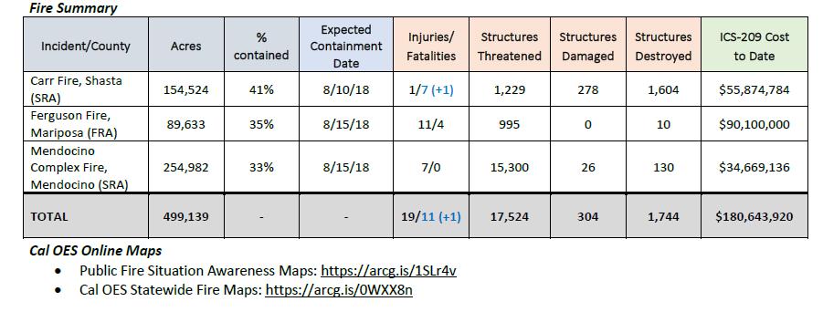
1 BUSINESS OPERATIONS CENTER SITUATION REPORT 8/5 / H STATEWIDE FIRE ACTIVITY (As of 10:00AM) INLAND REGION Ferguson, Vegetation Fire, Mariposa County Location: Hwy. 140 x Hite Cove, Near El Portal Jurisdiction: Federal DPA, FRA, Madera-Mariposa-Merced Unit/Sierra National Forest Start Date/Time: 07/13/18 at 2035 hours Per Cal OES Duty Officers and ICS-209 as of 08/05/18 at 0814 hours: 89,633 acres, 36% contained Destroyed Structures: 7 residences, 3 other minor structures Active fire behavior with running, short-range spotting and group torching Road closures in effect for State Route 140 and numerous roads in the fire area All area campgrounds remain closed Transmission lines along Hwy 140 and Yosemite National Park remain threatened Structures remain threatened Fire is burning in a high tree mortality area 2 Firefighter fatalities 2 Civilian fatalities (from fire-related traffic collision) Mandatory Evacuations Yosemite National Park evacuation of employees and residents in Yosemite Valley The Park will remain closed through 08/05/18
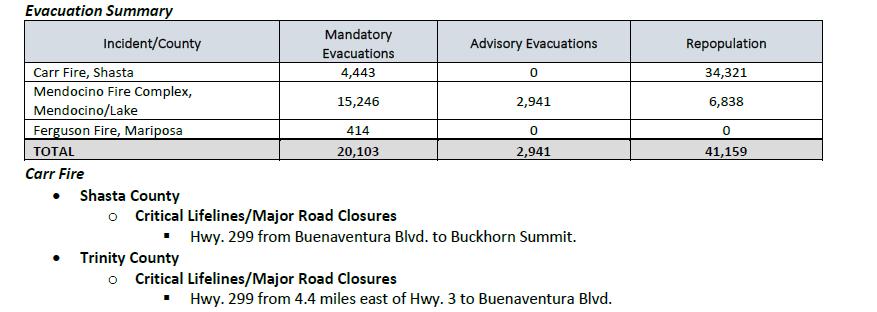
2 El Portal Community, 08/03/18 at 1749 hours 414 persons (08/02/18, 1630 hours) Community of Wawona Anderson Valley River Rd. from Briceburg to last BLM Campground Foresta Old El Portal Old Yosemite Rd. Yosemite View Lodge Yosemite West Road Closures As of 08/04/18 at 0802 hours, no road closures. Shelters New Life Christian Fellowship, 5089 Cole Rd, Mariposa Midnight Shelter Count: 75 Animal Shelters Small Animal Shelter: SPCA of Mariposa County, 5599 CA-49, Mariposa Large Animal Shelters: Coarsegold Rodeo Grounds: Rodeo Grounds Ln., Coarsegold (standby status) Critical Infrastructure PG&E 564 power outages 2
3 Carr, Vegetation Fire, Shasta/Trinity Counties Location: Hwy. 299 x Carr Powerhouse Rd., Whiskeytown Jurisdiction: Federal/State DPA, FRA/SRA, Whiskeytown National Park/Shasta-Trinity Unit Start/Date Time: 07/23/18 at 1316 Per Cal OES Duty Officers and ICS-209 as of 08/05/18 at 0814 hours: 154,524 acres, 41% contained Damaged Structures: 190 residences, 2 mixed commercial/residential, 26 nonresidential commercial properties, 60 other minor structures Destroyed Structures: 1,078 residences, 24 nonresidential commercial properties, 500 other minor structures Keswick Dam is restricted to minimal electrical output due to damaged powerlines Continued threat to 115kV and 230kV powerlines Continued threat to Western Area Power Administration (WAPA) towers, which powers numerous Northern Coastal Communities Repopulation is continuing approximately 21,501 civilians still currently displaced Continued evacuations for the portions of Old Shasta and Keswick Damage assessment is continuing Hwy 299 W remains closed in both directions 2 Firefighter fatalities 5 Civilian fatalities Evacuations Mandatory Evacuations: 4,443 persons (as of 08/04/18, 1200 hours) Fire Repopulation: 34,321 (as of 08/04/18, 1200 hours) Shasta County: Community of French Gulch SR 299 west of Trinity Mountain Rd. to the base of Buckhorn Summit Whiskey Creek Rd. to include the boat launch/day use areas 3
4 South along Swasey Dr. from SR299 to Placer Rd. Placer Rd. West From Swasey Dr. The Igo Community Old Shasta & Keswick Communities West of Keswick Dam Cloverdale Rd. from Placer Rd. to Clear Creek Rd. Placer Rd. at Platina Rd. to Buell Rd. which includes South Fork Rd., Zogg Mine Rd., Jenny Bird Ln., Horse Canyon Rd. and all residents West of Platina Rd. between Placer Rd. and Buell Rd. All areas on South Fork Rd. from Zogg Mine Rd. to South Fork Rd. to include the areas of Bender Rd., Serenity Dr. and Serenity Wy. City of Redding: The entire City of Redding has repopulated as of 08/04/18 at 1100 hours. Trinity County: Trinity/Shasta County Line at Buckhorn Summit Rd. west to Trinity Dam Rd., and all Rd.s within this area north of Hwy. 299 Hwy. 299 at Trinity Dam Blvd. continuing north to Trinity Dam including Deadwood Rd., Jennings Gulch Rd., Eastman Gulch Rd. and Lewiston Turn Pike Rd. This is to include all residences and side streets east of Trinity Dam Blvd. within the Township of Lewiston. Hwy. 299 at Trinity Dam Rd. west to Douglas City Trinity Dam Rd. Blvd. to Hwy. 3 including all residences within Lewiston area to Trail Dr., Red Ln., Old Hwy., Lewiston Rd., Ohio Ln., Lowden Wy., Ponderosa Pines, River Front Rd., Wellock Rd., S. Ponderosa Pine, Coffin Rd., Dirt Rd., Benvenuto Wy., Browns Mountain Rd., Mountain Springs Rd., Jobe Wy., Steelhead Cir., Rebel Rd., Quail Point Rd., Lockhart Ranch Rd., Prut Rd., Upper Salt Flat Rd., Salt Flat Rd., Goose Ranch Rd., Dredger Ln., Bacham Ln., Partridge Ln., Shady Ln., River Rock Rd., Old Oak Rd., Gulch Rd. and Lewiston Turn Pike Rd. All roads and streets west of Trinity Dam Blvd. and east of Lewiston Rd. Deadwood Rd. east of Trinity Dam Blvd. All residences on Baker Rd. including Cooper Gulch, Posey Rd., Lakeview Terrace and Pine Cove Marina including Eagle Mountain Rd. Road Closures 4
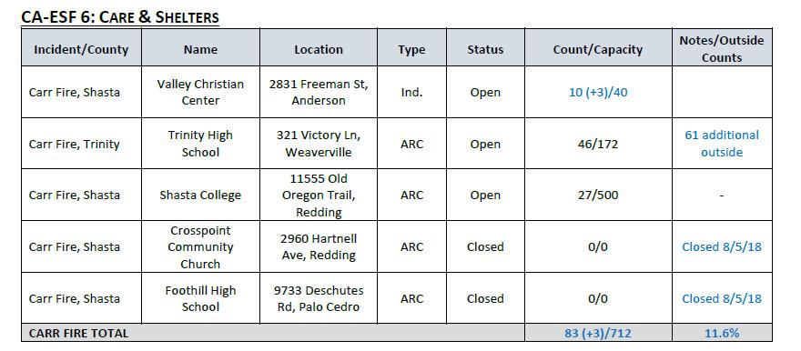
5 Hwy 299 from Buenaventura Blvd. to Buckhorn Summit Shelters There are approximately 10,000 additional cots at the Redding Municipal Airport to support multiple Northern California fires Shasta County: Shasta College, Old Oregon Trail, Redding Count: 27 Crosspoint Community Church, 2960 Hartnell Ave., Redding Count: 13 Foothill High School, 9733 Deschutes Rd., Palo Cedro Count: 4 Valley Christian Center, 2831 Freeman St., Anderson Count: 7 Trinity County: Trinity High School, 321 Victory Ln., Weaverville Count: 246 Animal Shelters Shasta Livestock Auction, 3917 Main St., Cottonwood Small and Large Animals Lassen County Fair, 195 Russell Ave., Susanville Large Animals Colusa County Fair, th St., Colusa Small and Large Animals Lowden Park, Lowden Ln. & Washington St., Weaverville Large Animals Trinity High School, 321 Victory Ln., Weaverville Small and Large Animals Trinity County Animal Control Office, 563 Mountain View, Weaverville Small Animals Critical Infrastructure 5
6 Shasta CSD, Surface Water Treatment Plant, system remains on boil water notice. Operational on generator power. PG&E 1,442 power outages, 52 gas outages: PG&E has begun limited restoration efforts in burn area. Redding Electric 0 power outages 2 cell site down All Bureau of Reclamation power plants near the Carr Fire area have been tested and are operational. Health and Medical Patients' Hospital of Redding is still under evacuation orders as of 08/03/18 at 1141 hours. Mercy Medical Center Redding is open and operational. ED is open to all transfers. Hospital command center is active. Facility is staffed 24/7 through weekend. COASTAL REGION Mendocino Complex (River and Ranch), Vegetation Fire, Mendocino/Lake Counties Location: Old River Rd., near Mile Marker Post 7.9, 6 miles N of Hopland Jurisdiction: State DPA, SRA, Mendocino Unit Start date: 07/27/18 Per Cal OES Duty Officers and ICS-209 as of 08/05/18 at 0814 hours: 229,006 acres, 33% contained Damaged Structures: 10 single residences, 11 other minor structures Destroyed Structures: 54 single residences, 1 multiple residence, 49 other minor structures Fire behavior, remained active overnight Cow mountain area is under a Mandatory evacuation order Fire continues to move to the east towards to the Pawnee burn scar Continued threat to 115 kv powerlines Damage assessment is continuing 6
7 Evacuations Mandatory Evacuations: 7,635 persons (08/02/18, 1640 hours) Lake County: (13,540 persons, 08/03/18 at 1200 hours) Lake Pillsbury area North of Highway 20, east of the Lake-Mendocino County Line, south of the Lake-Mendocino County Line, west of the Lake-Glenn County Line. This includes the areas of Lake Pillsbury, Elk Mountain Rd., Bear Creek, Pine Mountain, and the surrounding areas. 15,246 persons (08/04/18 at 1407 hours). Double Eagle at Hwy. 20 (Ranch Fire) 40 persons (08/04/18 at 1333 hours). Lucerne, Glenhaven, and Clear Lake Oaks (6000 persons), 08/03/18 at 1040 hours Hwy 20-Blue Lakes Area 8/3/18 at 1310 hours South of Highway 20, East of Lake Mendocino, Russian River, North of Yokayo Rancheria Rd and West of the intersection of Cow Mountain Access Rd and North Cow Mountain Rd. To include: McClure Creek Subdivision, City of Ten Thousand Buddhas, Sanford Ranch Rd, Knob Hill area, Regina Heights, Vichy Hills, Vichy Springs Resort, Guideville Reservation, Sulpher Creek, Deerwood Subdivision, El Dorado Subdivision, Howard Creek, Rafello Dr, Vista Del Largo, Kings Ranch Rd, Elledge Ranch Rd. (2,416 person) (8/3/18 at 1624). Cow Mountain Recreation Area Mendocino County, East Mill Creek Rd at North Cow Mountain and Cow Mountain Access Rd, East to Mendocino Lake County Line and North to Highway 20 due to fire in the area. Long Valley, High Valley and Spring Valley in Lake County - 1,224 persons Western Lake County, north of the Lake-Sonoma County Line and Bartlett Springs Rd., east of the Lake/Mendocino County Line, south of the Ranch Fire, and west of Highland Springs Rd. Big Valley Rd., and Bartlett Springs Rd. to include the communities of Lakeport, Scotts Valley Upper Lake, Bachelor Valley, and Nice. West of Lucerne at Bartlett Springs Rd. and Highway CA-20, south of the fire, east of the fire, north of Clear Lake including the communities of Blue Lakes, Upper Lake, Nice, Lakeport, Witter Springs, Bachelor Valley, Scotts Valley, Saratoga Springs. Mendocino County: (95 persons) Community of Potter Valley area: East of Eastside Potter Valley Road and Eel River Road, south of the Eel River, west of Mendocino Lake County line and north of Mid Mountain Road. (82 persons) - (8/3/18 at 1447 hours). 7
8 Hwy. CA-20 area from one mile south of Highway CA-20, east of Potter Valley Rd., south of the fire perimeter, and west of Mendocino/Lake County Line. Pine Ave. area of Potter Valley north of Burris Ln., east of Eastside Potter Valley Rd., south of Eastside Potter Valley Rd., and west of the Lake-Mendocino County Line. Mid Mountain Rd. area, north of Eastside Potter Valley Rd., east of Eastside Potter Valley Rd., south of Eastside Potter Valley Rd., west of Mendocino-Lake County Line Road Closures Hwy 20- Closed from Potter Valley Road to SR 53 Hwy 29- Closed from Park Way Road to SR 20 Hwy 20 from State Route 53 Junction to Walker Ridge Rd. Hwy 175 between Hopland and Hwy 29 Hwy 20 between Potter Valley Rd and Hwy 29 Shelters Lake County: Twin Pines Casino, S State Hwy. 29, Middletown Count: 154 Middletown High School, Big Canyon Rd., Middletown Pets allowed co-located at shelter, limited capacity for large animals Count: 193 Lower Lake High School, 9430 Lake St., Lower Lake Count: 300 Mountain Vista Middle School, 5081 Konocti Rd., Kelseyville Count: 22 Mendocino County: Mendocino College, 1000 Hensley Creek Rd., Ukiah Count: 50 8
9 Napa County: Napa County Fairgrounds, 1435 N. Oak St., Calistoga Standby Status Humboldt County: Blue Lake Casino Hotel, 777 Casino Way, Blue Lake Count: 6 from Trinity County, 2 from Shasta County Animal Shelters Sonoma-Marin Fair, 175 Fairgrounds Dr., Petaluma, (All Animals) Redwood Riders Arena, 8300 East Rd., Redwood Valley (Small and Large Animals) Mendocino County Animal Shelter, 298 Plant Rd., Ukiah (Small Animals) Critical Infrastructure PG&E reports that 942 customers remain without power. As of 08/03/18 at 1910 hours, potential for impacts to the Cow Mountain Repeater site. Schools The Lakeport Unified School District does not anticipate staff returning before 08/16/18 and students to begin school before 08/22/18. SOUTHERN REGION Cranston, Vegetation Fire, Riverside County (Final) Location: Hwy. 74 x Control Rd., 7 miles E of Hemet Jurisdiction: Federal DPA, SRA/FRA, Riverside Unit, San Bernardino National Forest Start date/time: 07/25/18 at 1141 hours Per Cal OES Duty Officers and ICS-209 as of 08/05/18 at 0814 hours: 13,137 acres, brush and timber, 96% contained 9


10 Minimal fire behavior, backing, smoldering, and creeping Hwy 243 has reopened to the public Hwy 74 is open with escort to and from Mountain Center 10

11 11 4:00PM Update
12 12
13 13
14 14


15 15

16 16
17 17

18 18
Business Operations Center Situation report 8/13 / hrs
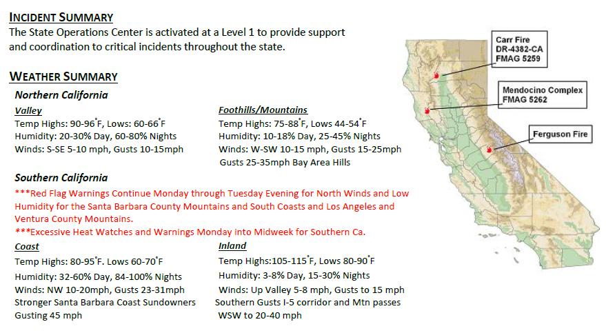
 INCIDENT SUMMARY The State is activated at a Level 1 to provide support and coordination to critical incidents throughout the state. WEATHER SUMMARY Northern California Valley Foothills/Mountains Temp
Opened and Closed Bank Branch Report (March 2014 thru YTD)
") Opened and Closed Bank Rept (March 2014 thru YTD) Closure Turlock 2001 Geer Rd Turlock Stanislaus CA 95383 0039.07 Upper No Opened 1/14/2019 Turlock 2900 Geer Rd Turlock Stanislaus CA 95382 0039.07 Upper
Opened and Closed Bank Rept (March 2014 thru YTD) Closure Turlock 2001 Geer Rd Turlock Stanislaus CA 95383 0039.07 Upper No Opened 1/14/2019 Turlock 2900 Geer Rd Turlock Stanislaus CA 95382 0039.07 Upper
SHASTA WEST PLANNING AREA
 2016 SHASTA COUNTY COMMUNITY WILDFIRE PROTECTION PLAN SHASTA WEST PLANNING AREA Covering the communities of: Centerville Redding (west & downtown) Shasta I. PROPOSED PROJECTS A. THE PLANNING AREA SHASTA
Presented by Bensinger, DuPont & Associates
 Problem Gambling Help Line Report 12 Presented by Bensinger, DuPont & Associates For California Council on Problem Gambling Bensinger, DuPont & Associates 134 N. LaSalle, Suite 2200 Chicago, Illinois 60602
State Operation Center Situation Status Report November Wildfires
 FIRE ACTIVITY INLAND REGION Camp, Vegetation Fire, Butte County Location: Pulga road X Camp Creek road, Jarbo Gap Jurisdiction: State DPA, SRA, Butte Unit Start Date/Time: 11/08/18, 0633 hours: Per Cal
Family Law Court Contact Information
 Family Law Court Contact Information County Alameda Alpine Amador Butte Calaveras Colusa Contra Costa Alameda Superior Court Hayward Hall of Justice 24405 Amador Street, Hayward, CA 94544 Alpine County
Table A. List of Mercury-Impaired Reservoirs Included in the Statewide Mercury Control Program for Reservoirs. County(ies) Owner
 Owner") Table A. List of Mercury-Impaired s Included in the Statewide Mercury Control Program for s Almanor, Lake 5 Plumas Pacific Gas and Alondra Park Lake 4 Los Angeles Los Angeles County Amador, Lake* 5 Amador
Table A. List of Mercury-Impaired s Included in the Statewide Mercury Control Program for s Almanor, Lake 5 Plumas Pacific Gas and Alondra Park Lake 4 Los Angeles Los Angeles County Amador, Lake* 5 Amador
Allocation of the Education Revenue Augmentation Fund for Community College Districts
 STATE OF CALIFORNIA BRICE HARRIS, CHANCELLOR CALIFORNIA COMMUNITY COLLEGES SYSTEM OFFICE 1102 Q STREET SACRAMENTO, CA 95811-6549 (916) 445-8752 HTTP://WWW.CCCCO.EDU June 4, 2013 To: From: Subject: Auditors
RECREATION AND RESORT PROJECTS
 RECREATION AND RESORT PROJECTS Coyote Moon Golf Clubhouse, Truckee, CA Dollar Point Pool and Tennis Club, Tahoe City, CA Donner Lake Boat Ramp, Truckee, CA Tahoe Swiss Village Beach and Shore Frontage,
Estimated Allocation of the Education Revenue Augmentation Fund for Community College Districts
 STATE OF CALIFORNIA BRICE HARRIS, CHANCELLOR CALIFORNIA COMMUNITY COLLEGES SYSTEM OFFICE 1102 Q STREET SACRAMENTO, CA 95811-6549 (916) 445-8752 HTTP://WWW.CCCCO.EDU June 10, 2015 To: From: Subject: Auditors
Estimated Allocation of the Education Revenue Augmentation Fund for Community College Districts
 STATE OF CALIFORNIA BRICE HARRIS, CHANCELLOR CALIFORNIA COMMUNITY COLLEGES SYSTEM OFFICE 1102 Q STREET SACRAMENTO, CA 95811-6549 (916) 445-8752 HTTP://WWW.CCCCO.EDU June 16, 2014 To: From: Subject: Auditors
Estimated Allocations of the Education Revenue Augmentation Fund for Community College Districts
 STATE OF CALIFORNIA BRICE W. HARRIS, CHANCELLOR CALIFORNIA COMMUNITY COLLEGES CHANCELLOR S OFFICE 1102 Q STREET, STE. 4554 SACRAMENTO, CA 95811-6549 (916) 445-8752 http://www.cccco.edu MEMORANDUM Date:
2019 CALPERS MONTHLY PREMIUMS BAY AREA REGION EMPLOYEES REPRESENTED BY UNITED CHIEF OFFICERS' ASSOCIATION BARGAINING UNIT HA
 BAY AREA REGION $831.44 $652.01 $179.43 $1,662.88 $1,304.00 $358.88 $2,161.74 $1,695.21 $466.53 $1,111.13 $725.04 $386.09 $2,222.26 $1,450.06 $772.20 $2,888.94 $1,885.09 $1,003.85 * BLUE SHIELD ACCESS+
Business Operations Center Situation Status Report
 INCIDENT SUMMARY The State Operations is activated at a Level 1 to provide support and coordination for the California wildfires. WEATHER SUMMARY Northern California Valley Temps: Highs: 60-70ºF, Lows:
2018 CALPERS MONTHLY PREMIUMS BAY AREA REGION EMPLOYEES REPRESENTED BY UNITED CHIEF OFFICERS' ASSOCIATION BARGAINING UNIT HA
 BAY AREA REGION $856.41 $664.49 $191.92 $1,712.82 $1,328.97 $383.85 $2,226.67 $1,727.67 $499.00 $925.47 $632.21 $293.26 $1,850.94 $1,264.40 $586.54 $2,406.22 $1,643.73 $762.49 $889.02 $597.18 $291.84 $1,778.04
State Transit Assistance Program Allocations - Estimated Regional Amounts Per SB 1. Projected STA Allocation (FY , Total - Includes TIF)
") Regional Entity Existing 4.75%) State Transit Assistance Program s - Estimated Regional Amounts Per SB 1 New # % Total - Existing 4.75%) New Total - Metropolitan Commission (9 SF Bay Area Counties) $115,038,056
Regional Entity Existing 4.75%) State Transit Assistance Program s - Estimated Regional Amounts Per SB 1 New # % Total - Existing 4.75%) New Total - Metropolitan Commission (9 SF Bay Area Counties) $115,038,056
Typhoid Fever Yearly Summary Report
 State of California California Department of Public Health Mark B. Horton, MD, MSPH Director Arnold Schwarzenegger Governor Typhoid Fever Yearly Summary Report 2001-2008 Center for Infectious Diseases
Court Executive Officers and Fiscal Contacts:
 From: Ng, Melissa [mailto:melissa.ng@jud.ca.gov] Sent: Thursday, October 4, 2018 4:44 PM To: JCC Execs - ALL Trial s; JCC Budget Services Contacts (Trial s) Cc: TCs Subject: Judicial Council s to Trial
JOHN CHIANG California State Controller
 JOHN CHIANG California State Controller Division of Accounting and Reporting January 25, 2013 COUNTY AUDITORS RESPONSIBLE FOR STATE TRANSIT ASSISTANCE FUNDS TRANSPORTATION PLANNING AGENCIES COUNTY TRANSPORTATION
Santa Cruz North Interior
 Santa Cruz North Interior The Santa Cruz North Interior planning area includes the area commonly referred to as the San Lorenzo Valley. The greatest amount of development occurs in the communities of Boulder
FOR SALE Wallner Ranch
 FOR SALE Wallner Ranch 857± Acres Mariposa County, California Exclusively Presented By: Pearson Realty Year round livestock grazing Abundant wildlife Great recreational property CA BRE #00020875 Wallner
Santa Cruz North Interior
 Santa Cruz North Interior The Santa Cruz North Interior planning area includes the area commonly referred to as the San Lorenzo Valley. The greatest amount of development occurs in the communities of Boulder
Mariposa County - All CUPA Facilities
 FACILITY_NAME STREET_NUMBER STREET_NAME Above All Towing 4995 Gold Leaf Allison Sierra, Inc. 5044 Fairgrounds AT&T Mobility - Coulterville 4989 Penon Blanco AT&T Mobility - Lake McClure #38409 Unassigned
Rule 20A - Projects in the Queue
 ALAMEDA ALAMEDA HESPERIAN BLVD ENGINEERING PHASE ALBANY ALAMEDA BUCHANAN ST & MARIN AVE PH 1 ENGINEERING PHASE AMERICAN CANYON NAPA GREEN ISLAND DR PLANNING PHASE ARROYO GRANDE SAN LUIS OBISPO GRAND AVE
EXHIBIT B PROCEDURE FOR ESTABLISHMENT AND MAINTENANCE OF LIST OF QUALIFIED CONTRACTORS PER SECTION OF THE PUBLIC CONTRACT CODE
 EXHIBIT B PROCEDURE FOR ESTABLISHMENT AND MAINTENANCE OF LIST OF QUALIFIED CONTRACTORS PER SECTION 22034 OF THE PUBLIC CONTRACT CODE 1. During November each year, each Public Agency which has elected to
Region MHz channel selection and usage documentation. Version 6
 Region 6 700 MHz channel selection and usage documentation Version 6 Applicant information The Golden Gate Bridge, Highway and Transportation District is a Special District formed by the California Legislature
California Community Colleges Budget Workshop Tab 3 - Apportionments Table of Contents
 Tab 3 - Apportionments Table of Contents Tab 3 - Apportionments Documents 1. Estimated 213-14 Base Revenue 2. Estimated 213-14 Base FTES 3. Estimated 213-14 Local Revenue 4. Summary - 213-14 Stability
Comparative Debt Measures California Counties As of June, Summary
 Supplemental Data Sheet Comparative Debt Measures California Counties As of June, 2007 Summary Based on data in the most recent SCO Counties Annual Report (2007), compared to all other California Counties,
13.1 REGIONAL TOURISM ISSUES AND SUMMARY OF FINDINGS
 13 REGIONAL TOURISM T he County of Mariposa s recreation needs and facilities fall within two categories: regional tourism and local recreation. This Element focuses on regional tourism issues related
NOTICE OF DESIGNATED POLLING PLACES FOR THE MAY 19, 2009 STATEWIDE SPECIAL ELECTION
 NOTICE OF DESIGNATED POLLING PLACES FOR THE MAY 19, 2009 STATEWIDE SPECIAL ELECTION NOTICE IS HEREBY GIVEN of designated polling places for the May 19, 2009 Statewide Special Election. You will find your
Chapter 2: El Dorado County Characteristics and Demographics
 Chapter 2: El Dorado County Characteristics and Demographics 2.1 Geographic Area and Demographics El Dorado County comprises 1,805 square miles with over half of the area in the Eldorado National Forest
Forest Fire Lookout Association
 Forest Fire Lookout Association CA-Pacific Area Chapter 30021 McKenna Heights Court, Valley Center CA 92082 2018 ANNUAL REPORT Hi Samsara, Bad news first, Two Fire Lookout Towers in CA-Pacific was lost
BEGINNER. mayorsmtbchallenge.org
 mayorsmtbchallenge.org Redding s second local Mountain Bike Challenge uniting current and new bicyclists in a friendly self-competition highlighting our diverse trail system. BEGINNER N Churn Creek Greenway
Rule 20A - Projects in the Queue
 ALAMEDA ALAMEDA HESPERIAN BLVD ENGINEERING PHASE ALBANY ALAMEDA BUCHANAN ST & MARIN AVE PH 1 CONSTRUCTION PHASE AMERICAN CANYON NAPA GREEN ISLAND DR ENGINEERING PHASE ARROYO GRANDE SAN LUIS OBISPO GRAND
Appendix - J. Public Services. List of Parks in the County of Santa Cruz
 Appendix - J Public Services List of Parks in the County of Santa Cruz Regulations and Licensing Program EIR County of Santa Cruz This Page Intentionally Left Blank. Regulations and Licensing Program EIR
PRESENTS A RARE AND UNIQUE DEVELOPMENT OPPORTUNITY THE HISTORIC WHITE CHIEF LODGE FISH CAMP, CALIFORNIA
 MVP COMMERCIAL Hotel-Motel and Investment Brokerage PRESENTS John R. Reed, CCIM P. O. Box 338 Oakhurst, CA 93644 559.683.7474 Voice 559.683.7393 Fax 559.288.2488 Cell A RARE AND UNIQUE DEVELOPMENT OPPORTUNITY
July 7, 2014 CALIFORNIA INDIAN GAMING OPERATIONS 1. Number Key to California Map
 CALIFORNIA INDIAN GAMING OPERATIONS 1 Number Key to California Map Agua Caliente Band of Cahuilla Indians 5401 Dinah Shore Dr., Palm Springs CA 92264 Map designation: (1) Agua Caliente Casino 32-250 Bob
El Dorado County / Tahoe Roadwork Schedule Sunday through Saturday September 9 September 15, 2012
 Today s Date: Friday, September 7, 2012, #12-255 District: District 3 - Marysville, http://www.dot.ca.gov/dist3 Jody Jones, District Director Contact: Deanna Shoopman deanna_shoopman@dot.ca.gov 530. 741.4566
Recommended Notary Services
 Recommended Notary Services Alameda County Amy Lin 1.510.828.3783 1.510.740.3582 amynotary@gmail.com www.notary.net/websites/amylin Chineese, Cantonese, Mandarin, Punjabi, Hindi, Urdu None Kin Deol 1.510.760.0970
CSU Local Admission and Service Areas
 CSU Local Admission and Service Areas CSU Local Admission Areas Service Areas Campus First-Time Freshman Upper-Division Transfer Outreach, Recruitment, EAP Bakersfield State of California State of California
Map Mendocino County - Wireline Broadband
 Map 1.0 - County - Wireline Broadband 62 Cleone Brooktrails Caspar Little Comptche Potter Albion Calpella Talmage 6 Down / 1.5 Up Philo 28 ÿ 253 75 Hopland ÿ 281 County 0 5 10 20 Miles Date: 8 March 2017
Alumni. Section 8: Alumni
 Alumni Section 8: Alumni This section includes a table and three maps showing the distribution of all living alumni in California counties, in each state, and across the world. All data was provided by
Full-Time Faculty Salary Comparisons in the California Community Colleges
 Full-Time Faculty Salary Comparisons in the California Community Colleges 2017-18 Full-Time Faculty Salary Comparisons in the California Community Colleges 2017-18 Table of Contents OBJECTIVE AND METHODOLOGY
BROCHURE. APPLE HILL WOODS 118 +/- Acres Camino, California. Presented by Jim Copeland
 BROCHURE APPLE HILL WOODS 118 +/- Acres Camino, California Presented by Jim Copeland 1 The Property This 118 acre is a rare gem in the Sierra Nevada foothills. Covered with lush forestland and scattered
flyrideusa com Classic Routes Itineraries Motorcycle Vacations
 flyrideusa com Classic Routes Itineraries Self-guided Tour Itineraries California Dreaming American Southwest American Rockies Canadian West American West Northwest Discovery flyrideusa com TM California
California Travel Impacts by County,
 California Travel Impacts by County, 1992-2012 2013 Preliminary State & Regional Estimates May 2014 A Joint Marketing Venture of the California Travel & Tourism Commission and the Governor's Office of
Recreation Areas (2010)
") AREA 1 - PIT RIVER / HAT CREEK / BATTLE CREEK BAUM LAKE FISHING ACCESS 1 $0 OPEN ALL YEAR OPEN ALL YEAR BIG LAKE FISHING ACCESS 1 $0 OPEN ALL YEAR OPEN ALL YEAR CASSEL CAMPGROUND 1 $22 04/02/10 11/15/10;
AREA 1 - PIT RIVER / HAT CREEK / BATTLE CREEK BAUM LAKE FISHING ACCESS 1 $0 OPEN ALL YEAR OPEN ALL YEAR BIG LAKE FISHING ACCESS 1 $0 OPEN ALL YEAR OPEN ALL YEAR CASSEL CAMPGROUND 1 $22 04/02/10 11/15/10;
RECREATION ACCESS AND COMMUNITY ENRICHMENT PLAN
 Template for facilitating Siskiyou County, the City of Yreka and the State of Jefferson in a RECREATION ACCESS AND COMMUNITY ENRICHMENT PLAN Access to the Mountains CREATING ACCESS TO PUBLIC AND PRIVATE
El Dorado County COMMUNITY WILDFIRE PROTECTION PLAN Community Tab for AUBURN LAKE TRAILS FIRE SAFE COUNCIL ACTIVITIES
 El Dorado County COMMUNITY WILDFIRE PROTECTION PLAN Community Tab for AUBURN LAKE TRAILS FIRE SAFE COUNCIL ACTIVITIES Prepared for Inclusion in the: EL DORADO COUNTY FIRE SAFE COUNCIL Community Wildfire
CalARVC White Paper on
 CalARVC White Paper on TOT the Good, the Bad, the Ugly and the Reality Written by Debbie Sipe, Executive Director California Association of RV Parks & Campgrounds January 2013 The Definition: Transient
Las Conchas Wildfire (NM):
:") Las Conchas Wildfire (NM): Progression, Management, and Context Kristen Honig Los Alamos National Laboratory July 24, 2012 LA UR 12 22538 Photo Credit: Kristen Honig Las Conchas Fire Background Fire Timeline/Summary
Las Conchas Wildfire (NM): Progression, Management, and Context Kristen Honig Los Alamos National Laboratory July 24, 2012 LA UR 12 22538 Photo Credit: Kristen Honig Las Conchas Fire Background Fire Timeline/Summary
ROUTE 2 BUS #29 WHITE BUS
 MAYER UNIFIED SCHOOL DISTRICT #43 2018-2019 PM BUS ROUTES PM TAKE HOME - ESTIMATED DROP OFF TIMES ROUTE 2 BUS #29 WHITE BUS BLACK CANYON CITY: HIGH SCHOOL PICK UP DROP OFF 2:35 PM BUMBLE BEE EXIT OFF 1-17
Recreation Facilities Guide 2004 Shasta-Trinity National Forest abckdvjw TRINITY
 Recreation Facilities Guide 2004 Shasta-Trinity National Forest abckdvjw TRINITY SHASTA SEASON OF USE Most recreation sites within the Shasta-Trinity National Forests are open from May 15 through September
County Name Phone Function(s) Address. F5AC Secretary/Treasurer
 Address. F5AC Secretary/Treasurer") F5AC / Primary Contact Master Roster County Name Phone Function(s) E-Mail Address Alameda Janis Burger 510/227-6900 510/227-6901F F5AC Secretary/Treasurer janis.burger@first5alameda.org First 5 Alameda
F5AC / Primary Contact Master Roster County Name Phone Function(s) E-Mail Address Alameda Janis Burger 510/227-6900 510/227-6901F F5AC Secretary/Treasurer janis.burger@first5alameda.org First 5 Alameda
Road and Trail Report 04/02/2015
 U.S.D.A. FOREST SERVICE KETCHUM RANGER DISTRICT 206 SUN VALLEY ROAD P.O. BOX 2356 KETCHUM, ID 83340 (208) 622-5371 Road and Trail Report 04/02/2015 o Dry weather and a dwindling snowpack continue to bring
% WORKING DISABLED PROGRAM - COUNTY COORDINATORS
 Page 1 of 6 2007 250% WORKING DISABLED PROGRAM - COUNTY COORDINATORS 01-ALAMEDA Social Agency 24100 Amador St., 6 th Flr. Hayward, CA 94546 LaTrelle L. Martin (510) 259-3882 (510) 259-3880 FAX E-Mail:
CA Regional Consortia - Strategic Broadband Corridors
 CA Regional Consortia - Strategic Broadband Corridors 199 Crescent City DEL NORTE Happy Camp ÿ 96 Yreka ÿ161 101 Etna ÿ 3 SISKIYOU 5 97 Arcata Eureka ÿ299 Mount Shasta ÿ 89 MODOC Alturas HUMBOLDT Weaverville
California Travel Impacts p
 California Travel Impacts 1992-2014p April 2015 A Joint Marketing Venture of Visit California and the Governor s Office of Business Development (GO-Biz) PREPARED BY Dean Runyan Associates, Inc. 833 SW
ATTACHMENT C (Department of Transportation Maintenance Areas and Delivery Locations)
") ATTACHMENT C (Department of Transportation s and s) Contract 1-10-56-10G Note: Only items listed on Attachment A (Contract Pricing) are included as part of this contract. CalTrans s and s Order 1 Humboldt
ATTACHMENT C (Department of Transportation s and s) Contract 1-10-56-10G Note: Only items listed on Attachment A (Contract Pricing) are included as part of this contract. CalTrans s and s Order 1 Humboldt
DRAFT: FOR REVIEW PURPOSES ONLY. NOT FOR DISTRIBUTION.
 BACKBONE ENTER TITLE TRAILS HERE MAP Existing Regional Class 1 Trail (paved, separated from roadway) Proposed Regional Class 1 Trail (paved, separated from roadway) Proposed Regional Multi-Use Trail (natural
AOTA ArtTrek Locations
 AOTA ArtTrek Locations ArtTrek is a summer-long Grand County, CO art adventure. Highlighted by snow-covered mountain vistas and rolling meadows threaded with sparkling streams and rivers, numerous sites
Morgan Estates. Lassen County, CA. Proudly Offered By
 Morgan Estates Lassen County, CA Proudly Offered By 707 Merchant Street, Suite 100, Vacaville, Ca 95688 (707) 455-4444 Office (707) 455-0455 Fax info@caoutdoorproperties.com Introduction Looking North
U.S.D.A. FOREST SERVICE KETCHUM RANGER DISTRICT 206 SUN VALLEY ROAD P.O. BOX 2356 KETCHUM, ID (208)
") U.S.D.A. FOREST SERVICE KETCHUM RANGER DISTRICT 206 SUN VALLEY ROAD P.O. BOX 2356 KETCHUM, ID 83340 (208) 622-5371 Road and Trail Report 05/8/2015 More trails opened in Greenhorn this week. Only high elevation
U.S.D.A. FOREST SERVICE KETCHUM RANGER DISTRICT 206 SUN VALLEY ROAD P.O. BOX 2356 KETCHUM, ID 83340 (208) 622-5371 Road and Trail Report 05/8/2015 More trails opened in Greenhorn this week. Only high elevation
List of Commanderies in California
 Name Charter Location List of Commanderies in California (San Francisco #1) *1853/1858 San Francisco California #1 name changed to California #1 8-11-1858 Sacramento #2 *1854/1858 Sacramento Pacific #3
Table 7-12: Approved Trails, Allowed Uses, and Restrictions
 Draft Revision: April 04 CVMSHCP Public Use and s Management for the Santa Rosa and San Jacinto Mountains Table 7-: s, Uses, and s The general geographic extent of recovery regions in the Plan Area is
List of Commanderies in California
 Name Charter Location List of Commanderies in California (San Francisco #1) *1853/1858 San Francisco California #1 name changed to California #1 8-11-1858 Sacramento #2 *1854/1858 Sacramento Pacific #3
Mendocino. County. California Resource & Relocation Guide
 Mendocino County California 2017-2018 Resource & Relocation Guide 1 Table Of Contents 4-5 Newcomer Information 6 Help Hotlines 7 Health & Hospitals 8 Local Education 11 Things To Do 14 State Information
Lava Mountain Trail Distance: Elevation Range: Trail Type: Difficulty: Season: Driving Distance: Driving Time: USGS Maps: Pros Cons
 Lava Mountain Trail Distance: 13.4 miles (including the side trip to North Star Lake) Elevation Range: 5900'-8330' Trail Type: singletrack Difficulty: moderate Season: late June-October Driving Distance:
Business Park. Amador Central. Offi ce / R&D Sites in Martell, CA FOR SALE & Build to Suit Opportunities DEVELOPMENT OPPORTUNITY. Blvd.
 DEVELOPMENT OPPORTUNITY Amador Central Business Park Offi ce / R&D Sites in Martell, CA FOR SALE & Build to Suit Opportunities 45 48 Locomoti ocomoti omo omo motive Ln Ln Ln Ln 47 46 44 35 Boxc xcar r
For Sale High Visibility Commercial Land Ridge Rd. Sutter Creek, CA
 12300 Ridge Rd. Sutter Creek, CA 6 PARCELS TOTALING 9.69± ACRES To Jackson To Stockton 49 To Sacramento 49 To Jackson Rancheria 104 Ridge Road Sara Wann, SREA Gina Motto-Ros, Agent 1201 North McDowell
[DIGNITY HEALTH VENTURA PLANS FACILITY NETWORK]
![[DIGNITY HEALTH VENTURA PLANS FACILITY NETWORK]](/thumbs/77/76663297.jpg "[DIGNITY HEALTH VENTURA PLANS FACILITY NETWORK]") CA DIGNITY HEALTH CLINICS (alphabetical by city) Angels Camp Medical Center 222 S. Main Street Angels Camp CA 95222 (209) 754-2968 Dignity Health Medical Group - Aptos Family Practice 9515 Soquel Drive,
CA DIGNITY HEALTH CLINICS (alphabetical by city) Angels Camp Medical Center 222 S. Main Street Angels Camp CA 95222 (209) 754-2968 Dignity Health Medical Group - Aptos Family Practice 9515 Soquel Drive,
MAYER UNIFIED SCHOOL DISTRICT # PM BUS ROUTES PM TAKE HOME - ESTIMATED DROP OFF TIMES
 MAYER UNIFIED SCHOOL DISTRICT #43 2017-2018 PM BUS ROUTES PM TAKE HOME - ESTIMATED DROP OFF TIMES ROUTE 2 BUS #45 WHITE BUS PICK UP DROP OFF BLACK CANYON CITY: HIGH SCHOOL DEPART MAYER HIGH SCHOOL 2:35
Southwest Quadrant Distinctive Features
 SOUTHWEST QUADRANT Southwest Quadrant Distinctive Features LAND USE The 31.17 square mile Southwest Quadrant includes all the area within the planning area west of I-5 and south of the Sacramento River.
BROCHURE. Brandy Hill Ranch 300 Acres Placerville, California
 BROCHURE Brandy Hill Ranch 300 Acres Placerville, California Presented by Jim Copeland Shown by appointment 1 The Property This 300-acre ranch is a rare gem in the Sierra Nevada foothills and is located
The Digital Divide in Assembly District 1: Broadband Wireline Service
 Assembly Served Underserved Unserved Total District 1 Households 149,339 63 % 32,755 14 % 54,828 23 % 236,922 100% Population 300,037 64 % 62,506 13 % 103,971 22 % 466,514 100% 35 Percentage Points Below
Organization Name Address City State Zip Code Phone Fax Fenton Avenue LLC Fenton Avenue Sylmar CA
 13333 Fenton Avenue LLC 13333 Fenton Avenue Sylmar CA 91342 818-367-1033 818-367-1394 13400 Sherman Way LLC 13400 Sherman Way North Hollywood CA 91605 818-983-0103 818-503-4438 5648 East Gotham Street
California Community College Libraries: hours (all respondents)
") California Community College Libraries: hours (all respondents) Regular term hours District College Credit 1 Chaffey Chaffey 15,891 87.0 2 Santa Barbara Santa Barbara 14,505 75.0 3 Los Rios Sacramento
California Community College Libraries: hours (all respondents) Regular term hours District College Credit 1 Chaffey Chaffey 15,891 87.0 2 Santa Barbara Santa Barbara 14,505 75.0 3 Los Rios Sacramento
Presented by Bensinger, DuPont & Associates
 Problem Gambling Help Line Report 13 Presented by Bensinger, DuPont & Associates For California Council on Problem Gambling Bensinger, DuPont & Associates 134 N. LaSalle, Suite 2200 Chicago, Illinois 60602
Kern-15 DAIRYMAN S BEEF AUCTION
 Department of Food & Agriculture Bureau of Livestock Identification Saleyard List 1220 N Street, Room A-130 Sacramento, CA 95814 Fresno-10 FRESNO LIVESTOCK COMMISSION CO. LLC Title:Phil Tews General Manager
CONTACT US. COMMERCIAL LAND FOR SALE High Identity Commercial Land ±15.33 ACRES AVAILABLE
 ±15.33 ACRES AVAILABLE USPS STANDARD RD CONTACT US Heath Kastner +1 916 446 8795 heath.kastner@cbre.com www.cbre.com/heath.kastner Lic. 01301753 CBRE, Inc. 500 Capitol Mall, Suite 2400 Sacramento, CA 95814
(Non-Faculaty) Professional. Allan Hancock College Allan Hancock Districtwide Total
 Professional. Allan Hancock College Allan Hancock Districtwide Total") EEO6 Occupational Activity Distribution by District/Primary Location Allan Hancock Allan Hancock College 31 667 39 80 93 9 46 0 965 Allan Hancock Districtwide 31 667 39 80 93 9 46 0 965 Antelope Antelope
EEO6 Occupational Activity Distribution by District/Primary Location Allan Hancock Allan Hancock College 31 667 39 80 93 9 46 0 965 Allan Hancock Districtwide 31 667 39 80 93 9 46 0 965 Antelope Antelope
RECREATION. Seven issues were identified that pertain to the effects of travel management on outdoor recreation within portions of the project area.
 RECREATION Seven issues were identified that pertain to the effects of travel management on outdoor recreation within portions of the project area. OPPORTUNITIES FOR SOLITUDE / QUIET TRAILS. One attraction
El Dorado County COMMUNITY WILDFIRE PROTECTION PLAN Community Tab for LAKEHILLS FIRE SAFE COUNCIL ACTIVITIES
 El Dorado County COMMUNITY WILDFIRE PROTECTION PLAN Community Tab for LAKEHILLS FIRE SAFE COUNCIL ACTIVITIES Prepared for Inclusion in the: EL DORADO COUNTY FIRE SAFE COUNCIL Community Wildfire Protection
Rogue Gorge (Mt. Stella) Roadless Area-- T30S R3E (primarily in portions of Sections 23, 26, 33, 34 & 35)
 Roadless Area-- T30S R3E (primarily in portions of Sections 23, 26, 33, 34 & 35)") Rogue Gorge (Mt. Stella) Roadless Area-- T30S R3E (primarily in portions of Sections 23, 26, 33, 34 & 35) Rogue River-Siskiyou National Forest--High Cascades Ranger District Upper, higher elevation trail
Rogue Gorge (Mt. Stella) Roadless Area-- T30S R3E (primarily in portions of Sections 23, 26, 33, 34 & 35) Rogue River-Siskiyou National Forest--High Cascades Ranger District Upper, higher elevation trail
California Agritourism
 California Agritourism Successes, Challenges and Changes Siskiyou Food Summit July 11, 2012 Penny Leff, Agritourism Coordinator UC Small Farm Program Agritourism is: Any income-generating activity conducted
Bradshaw Trails Series
 Bradshaw Trails Series Curtis James Troop 7014 Curtis.James@erau.edu My Motto: Never get lost! Hiking Rules Bradshaw Hiking Patch Series Hiking Tools Hiking Rules Hiking Merit Badge* Take five 10-mile
WARNING Due to Extensive Beetle Kill Trees, Trails are Subject to Closure or Rerouting. Please be Advised and Pay attention to On Ground Signage.
 WARNING Due to Extensive Beetle Kill Trees, Trails are Subject to Closure or Rerouting. Please be Advised and Pay attention to On Ground Signage. WYOMING RANGE WESTERN WYOMING The Wyoming Range trail system
B HALL RANCH FISHTAIL, MONTANA
 Brochure Courtesy of: B HALL RANCH FISHTAIL, MONTANA w w w. m c c a s l i n l a n d. c o m Page 1 LOCATION The Hall Ranch is ideally located in the foothills of the Beartooth Mountains, approximately 5
Existing Resource Information
 Botanical and Wildlife Vegetation alliances/wildlife habitats Grasslands annual/perennial Chaparral mixed/montane/chamise-redshank Riparian montane/valley foothill riparian Sierran mixed conifer Montane
CHAPTER 4 -- THE LAND USE PLAN: DESCRIPTIONS AND POLICIES FOR THIRTEEN PLANNING AREAS
 CHAPTER 4 -- THE LAND USE PLAN: DESCRIPTIONS AND POLICIES FOR THIRTEEN PLANNING AREAS SOUTH COAST CAC PLANNING AREA 4.11 MALLO PASS CREEK TO IVERSEN ROAD PLANNING AREA (Irish Beach/Manchester/Point Arena)
Recall: Osamu Corp. - Tuna California Retail Distribution List
 2600 S. VERMONT AVE. LOS ANGELES CA 90007 323-732-3863 1501 VINE STREET LOS ANGELES CA 90028 323-467-7916 7257 W SUNSET BLVD. LOS ANGELES CA 90046 323-512-8382 11727 OLYMPIC BLVD. LOS ANGELES CA 90064
OPEN SPACE. The Open Space Element describes the County s goals and policies with respect to open space areas and addresses the following topics:
 PURPOSE This element addresses open spaces for: the managed production of resources, outdoor recreation, public health and safety, and the preservation of natural resources. Amador County s open space
Facility Name* County Region ADIN AIRPORT Modoc 1 AGUA CALIENTE SPRINGS AIRPORT San Diego 6 AGUA DULCE AIRPARK Los Angeles 7 ALPINE COUNTY AIRPORT
 ADIN AIRPORT Modoc 1 AGUA CALIENTE SPRINGS AIRPORT San Diego 6 AGUA DULCE AIRPARK Los Angeles 7 ALPINE COUNTY AIRPORT Alpine 3 ALTURAS MUNICIPAL AIRPORT Modoc 1 ANDY MCBETH AIRPORT Del Norte 5 APPLE VALLEY
Early Trails of Southwestern Trinity County
 Early Trails of Southwestern Trinity County Thomas S. Keter Six Rivers National Forest May 1998 I have placed this article on the web for easier access to the public. It was first printed in Trinity the
Northeast Quadrant Distinctive Features
 NORTHEAST QUADRANT Northeast Quadrant Distinctive Features LAND USE The Northeast Quadrant includes all the area within the planning area that is east of Interstate 5 and to the north of State Route 44.
April 10, Mark Stiles San Juan Public Lands Center Manager 15 Burnett Court Durango, CO Dear Mark,
 Mark Stiles San Juan Public Lands Center Manager 15 Burnett Court Durango, CO 81301 Dear Mark, We are pleased to offer the following comments on the draft San Juan Public Lands Center management plans
San Mateo North - Coastal
 San Mateo North - Coastal The San Mateo North Coastal planning area covers the northwest portion of San Mateo County outside the cities of Half Moon Bay, El Granada and Moss Beach. The eastern boundary
Business Park. Amador Central. Office / R&D Sites in Martell, CA FOR SALE & Build to Suit Opportunities DEVELOPMENT OPPORTUNITY. lvd a.
 DEVELOPMENT OPPORTUNITY Amador Central Business Park Office / R&D Sites in Martell, CA FOR SALE & Build to Suit Opportunities ppo t ities e iv ot m co Lo 47 47 46 46 37 3 7 38 38 Ln 45 45 lvd rb a c 35
List of Polling Sites with Voting Precincts GENERAL ELECTION - November 04, 2014 Sorted by Voting Precinct ID
 List of Polling Sites with Voting Precincts GENERAL ELECTION - vember 04, 2014 Sorted by Voting Precinct 389 Sample Address Municipal Auditorium - Oroville Cross Street: Montgomery Street 1200 Myers Street
LAND FOR SALE SUBDIVISION LAND: SFR DEVELOPMENT LAND OF ±100 HOMES Ave 13 1/2, Madera, CA PROPERTY FEATURES
 SALE PRICE: $1,795,000 PRICE PER LOT: $18,505 PRICE PER SF: $2.35 LOT SIZE: 17.48 Acres APN #: 034-151-018 & -019 ZONING: PUD 6,000 R-1 Residential MARKET: City Of Madera PROPERTY FEATURES Shovel-ready