TECHNICAL MEMORANDUM. DATE: August 31, Pamela Dalcin-Walling/Dokken Engineering. Daniel Yau and Victor Baltazar/Y&C
|
|
|
- Wilfrid Boyd
- 5 years ago
- Views:
Transcription
1 DATE: August 31, 2017 TECHICAL MEMORADUM Y&C Transportation Consultants, Inc Ramos Circle Sacramento, CA Phone: (916) Fax (916) TO: FROM: SUBJECT: Pamela Dalcin-Walling/Dokken Engineering Daniel Yau and Victor Baltazar/Y&C Del Rio Trail Crossings Introduction Y&C Transportation has prepared this technical memorandum to summarize the analysis and recommendation for crossing treatments at locations proposed in the Del Rio Trail project. The proposed Del Rio Trail project will construct a 4.5-mile Class 1 pathway through South Land Park and neighboring areas between Interstate 5 and Freeport Boulevard. The new multi-use trail will run north to south and be constructed in place of the inactive Sacramento Southern Railroad line. See Figure 1 for Location Map. The new multi-use trail will cross adjacent roadways at the following 8 locations: 1. Sutterville Rd 2. South Land Park Dr 3. Del Rio Rd 4. Fruitridge Rd th Ave rd Ave/Blair Ave 7. Florin Rd 8. Meadowview Rd/Pocket Rd Appropriate crossing treatments are determined at each location based on City s guidelines and site specific conditions. Methodology The City of Sacramento Pedestrian Crossing Guidelines, dated October 2014, is used to determine the appropriate crossing treatment at each location. The City s evaluation of crossing treatments is organized into a progressive three-phase procedure. Using a flowchart, the first phase screens the uncontrolled location to determine whether or not it is a potential candidate for marked crossing. Criteria in this flowchart include pedestrian volumes, distance from the next nearest crossing, sight distance, and other considerations. See Exhibit 1: Uncontrolled Crosswalk Assessment Flowchart from City of Sacramento Pedestrian Crossing Guidelines in Appendix I. If the uncontrolled location meets the requirements in Phase 1, the next phase is to categorize the location using Table 2 in the City s guidelines. This table considers the Del Rio Trail Crossings Page 1 Y&C Transportation Consultants, Inc. August 31, 2017
 366-8000 Fax (916) 366-8008 location s posted speed limit, lane configuration, and average daily traffic volume to classify it under different")
2 Y&C Transportation Consultants, Inc Ramos Circle Sacramento, CA Phone: (916) Fax (916) location s posted speed limit, lane configuration, and average daily traffic volume to classify it under different categories of candidate sites for marked crosswalks at uncontrolled locations. See Section in the City s guidelines for details. See Table 2: Recommended Pedestrian Crossing Enhancement Treatments for Marked Crosswalks at Uncontrolled Locations from the City of Sacramento Pedestrian Crossing Guidelines in Appendix II. The final phase in the analysis procedure is to assign a crossing treatment to the uncontrolled location using both Table 1 and Table 2 in the City s guidelines. Principal treatments vary from basic markings to a full traffic signal. Additional supplemental treatments are also included to accommodate site specific conditions. See Table 1: Pedestrian Crossing Enhancement Treatments for Marked Crosswalks at Uncontrolled Locations from the City of Sacramento Pedestrian Crossing Guidelines in Appendix III. In addition to these guidelines, the engineer must use his/her engineering judgement of site conditions at each location to determine the appropriate crossing treatment. Analysis Results Phase 1: Initial Location Screening The first phase in the analysis procedure is to determine whether or not the uncontrolled location can be considered a candidate for marked crossing. The criteria analyzed in this phase are crossing demand, vehicle stopping sight distance, and distance to next nearest crosswalk. Pedestrian and bicycle demand along the proposed trail is projected using both the average adjusted peak-hour forecast method and the average adjusted 4-hour peak forecast method. The minimum peak hour demands for each method are 100 pedestrians/bikes per hour and pedestrians/bikes per hour, respectively. These forecasts apply to all locations along the trail. Both of these crossing demand projections are higher than the City s guideline of 20 pedestrians/bikes per hour. See Forecasted Trail Volumes in Appendix IV. Stopping sight distance was measured in the field for all locations requiring analysis. The design speed is assumed to be 5 mph higher than the posted speed limit in accordance with City s Project Delivery Manual. See Stopping Sight Distance Field Measurements in Table A below. ** See AASHTO Green Book Chapter for derivation of stopping sight distance. 180 = does not meet required stopping sight distance Del Rio Trail Crossings Page 2 Y&C Transportation Consultants, Inc. August 31, 2017
 366-8000 Fax (916) 366-8008 All measured locations have adequate sight distance with the exception of South Land Park Dr and Del Rio Rd.")
3 Y&C Transportation Consultants, Inc Ramos Circle Sacramento, CA Phone: (916) Fax (916) All measured locations have adequate sight distance with the exception of South Land Park Dr and Del Rio Rd. For both locations, a horizontal curve on the west leg limits the vehicle s view. We still consider both locations for further evaluation in Phase 2 and Phase 3. See Recommendation section for mitigation measures and enhancement treatments at these locations. With the exception of the stopping sight distance at South Land Park Dr and Del Rio Rd, the 5 northernmost locations in Table A meet the criteria in Phase 1 and are considered candidates for marked crossings. All 5 locations meet demand criteria, serve a trail, and are greater than 300 from the next nearest marked crossing. Trail crossings at the 3 southernmost locations (43 rd Ave/Blair Ave, Florin Rd, Meadowview/Pocket Rd) have adequate sight distance but are all within 300 of the next nearest marked crossing. According to the City s guidelines, these 3 locations are not candidates for marked crossings under normal circumstances. However, since these crossings serve a trail, further investigation regarding the marked crossings were performed consistent with City s guidelines. After further study, we recommend 43 rd Ave/Blair Ave as an exception to the 300 guideline. This location satisfies sight distance requirements, serves a trail, and is approximately 230 from the next nearest marked crossing. As mentioned in Section in the City s guideline, exceptions can be made to the 300 requirement if the proposed location serves a trail. The other 2 locations, Florin Rd and Meadowview/Pocket Rd, are not considered candidates for marked crossings. Trail users at these locations are expected to use the existing crosswalks on the west leg of the existing signalized intersection (within 100 of the proposed trail). FHWA recommends not to install marked crosswalks in close proximity of signalized intersections and to encourage pedestrians to cross at the traffic signal. See Summary of Initial Screening in Table B below. *Location does not meet sight distance requirements and/or is less than 300 to next nearest crossing but is still recommended for further evaluation consistent with City s guidelines. Del Rio Trail Crossings Page 3 Y&C Transportation Consultants, Inc. August 31, 2017
 366-8000 Fax (916) 366-8008 Phase 2: Additional Data Collection and Categorization of the Crossing Site The next phase in the analysis procedure is")
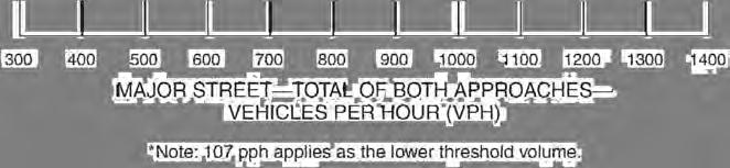
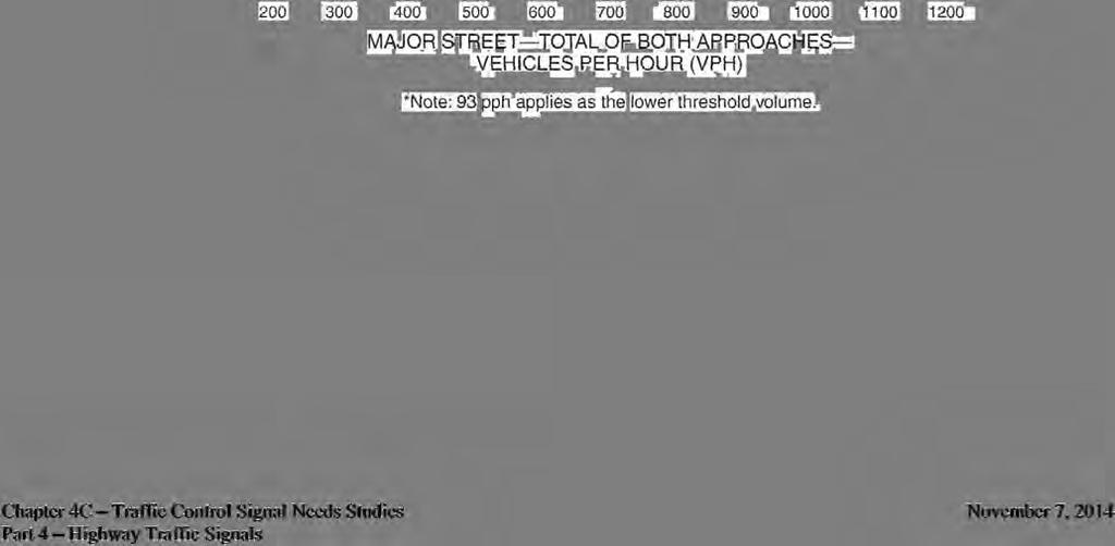
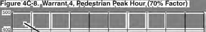
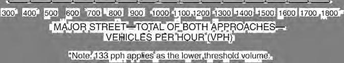
4 Y&C Transportation Consultants, Inc Ramos Circle Sacramento, CA Phone: (916) Fax (916) Phase 2: Additional Data Collection and Categorization of the Crossing Site The next phase in the analysis procedure is to categorize the crossing location using Table 2 in the City of Sacramento Pedestrian Crossing Guidelines. Traffic counts were conducted on Tuesday, March 7, 2017 for the 6 northernmost locations being analyzed. Speed limit data was provided by the City. See Appendix V for Traffic Count Data and Appendix VI for copies of City s Engineering and Traffic Surveys (E&TS). The Summary of Location Categorization is shown in Table C below. C = Candidate sites for marked crosswalks* P = Possible candidate sites for marked crosswalks* = Marked crosswalks alone are insufficient* BASIC = See Figure 3 in the City s guideline for Basic signing and marking treatment L1, L2, L3 = Recommended level of crossing treatment, see Table 1 in the City s guidelines * Refer to Exhibit 3 in the City s guidelines for description of category C, P, and Treatment levels Basic, L1, L2, and L3 are derived directly from Table 2 in the City s guidelines (included in Appendix II of this tech memo) and are based on the location s categorization. See Table 1 in the City s guidelines (included in Appendix III of this technical memorandum) for details on crossing treatment levels. Recommendation Phase 3: Treatment Selection and Implementation The final phase in the analysis procedure is to select an appropriate crossing treatment. Selection of enhancement treatments is based on the category of the crossing location as determined in Table C above. Principal and secondary enhancement treatments are assigned using the recommended treatment levels from Phase 2 of the analysis. See the Summary of Location Enhancement Treatments in Table D below. 1. Sutterville Rd This location is classified as Category "" with an "L3" treatment level. For this designation, a marked crossing alone is insufficient. A mid-block traffic signal is recommended at this location and is substantiated per Warrant 4 in Chapter 4C of the CA MUTCD. See Traffic Signal Warrant Analysis in Appendix VII. 2. South Land Park Dr In addition to the City s Basic signing and marking treatments for mid-block crosswalks at uncontrolled locations, an overhead 4-RRFB or Pedestrian Hybrid Beacon (PHB) should be considered as the principal treatment for this location due to Del Rio Trail Crossings Page 4 Y&C Transportation Consultants, Inc. August 31, 2017
5 Y&C Transportation Consultants, Inc Ramos Circle Sacramento, CA Phone: (916) Fax (916) inadequate sight distance for eastbound traffic on the west leg of this location. Inadequate sight distance is caused by the horizontal curve in the roadway. Further investigation indicates that the overhead 4-RRFB solution is more cost effective (installation costs for 4-RRFB and PHB are approximately $35,000 and $80,000, respectively). In addition, we recommend installing an advanced RRFB on South Land Park Dr, east of Parkside Ct for eastbound traffic. 3. Del Rio Rd A geometric realignment and a conversion to an all-way stop-controlled intersection are proposed at this location. Although this intersection does not warrant an all-way stop control under the City s stop control guidelines, there is strong community support for all-way stop control during the public outreach process. Besides, the allway stop control would enhance pedestrian and cyclist safety, especially for those on the trail approaching the crossing from the north while southbound motorists on Del Rio Rd are making right-turns. With the all-way stop control, the Del Rio Rd/ 27 th Ave intersection would operate at LOS A, which is acceptable to the City s standard. The geometric realignment will correct the existing stopping sight distance deficiency on the West leg of Del Rio Rd. With these modifications, the City s Basic signing and marking treatment is recommended as the principal treatment for this location. See Appendix VIII for City s Warrant for Three-way Stop Sign Locations and Appendix IX for Synchro Report. 4. Fruitridge Rd This location is classified as Category "" with an "L3" treatment level. For this designation, a marked crossing alone is insufficient. A mid-block traffic signal is recommended at this location and is substantiated per Warrant 4 in Chapter 4C of the CA MUTCD. Additionally, an advanced signal warning sign is recommended for the west leg of this location given both horizontal and vertical curves in the roadway. See Traffic Signal Warrant Analysis in Appendix VII th Ave We recommend installing the City s Basic signing and marking treatment as the principal treatment for this location. As secondary treatment, we recommend installing curb extensions to decrease crossing distance rd Ave/ Blair Ave We recommend installing the City s Basic signing and marking treatment as the principal treatment for this location. As secondary treatment, we recommend installing curb extensions to decrease crossing distance. Del Rio Trail Crossings Page 5 Y&C Transportation Consultants, Inc. August 31, 2017
 366-8000 Fax (916) 366-8008 C = Candidate sites for marked crosswalks* P = Possible candidate sites for marked crosswalks* = Marked crosswalks")
6 Y&C Transportation Consultants, Inc Ramos Circle Sacramento, CA Phone: (916) Fax (916) C = Candidate sites for marked crosswalks* P = Possible candidate sites for marked crosswalks* = Marked crosswalks alone are insufficient* BASIC = See Figure 3 in the City s guideline for Basic signing and marking treatment L1, L2, L3 = Recommended level of crossing treatment, see Table 1 in the City s guidelines * Refer to Exhibit 3 in the City s guidelines for description of category C, P, and Del Rio Trail Crossings Page 6 Y&C Transportation Consultants, Inc. August 31, 2017
7
8 APPEDIX I Uncontrolled Crosswalk Assessment Flowchart


9 City of Sacramento Pedestrian Crossing Guidelines October 2014 Exhibit 1: Uncontrolled Crosswalk Assessment Flowchart (Sheet 1 of 2) Phase 1: Initial Location Screening City Staff receives request for a marked crosswalk at an uncontrolled location City staff visits the site and collects data Location meets demand requirements (refer to ; & Exhibit 2, Item (1) for guidance) Location serves Location is o a trail or is on a direct still recommended o pedestrian route to for further evaluation o Yes destinations like a school, park, senior center, or hospital (refer to for guidelines) Location is currently not an appropriate site for marking the uncontrolled crossing Yes Would a marked crosswalk at this location be appropriate based on site conditions, ability to consolidate multiple crossing points, and channelize pedestrians? Yes o Yes Location is 300 from the nearest crossing (refer to ; & Exhibit 2, Item (4) for guidance) o Yes Location can be considered for exception to 300 distance (refer to ; & Exhibit 2, Item (5) for guidance) o Location is currently not an appropriate site for marking the uncontrolled crossing Yes (Continue to Sheet 2) 39
 for guidance) o Yes Can the sight distance obstruction(s) be removed?")
10 City of Sacramento Pedestrian Crossing Guidelines October 2014 (Continued from Sheet 1) Exhibit 1: Uncontrolled Crosswalk Assessment Flowchart (Sheet 2 of 2) Location meets the sight distance requirements (refer to ; & Exhibit 2, Item (6) for guidance) o Yes Can the sight distance obstruction(s) be removed? o Location is currently not an appropriate site for marking the uncontrolled crossing Yes Phase 2: Additional Data Collection and Categorization of the Crossing Site Categorize the crossing location site: Based on Exhibit 2 (Phase 2), and Exhibit 3 categorize the crossing location, in to one of the following: (1) Candidate site for a marked crosswalk (C) ; (2) Possible candidate site for a marked crosswalk (P) ; (3) Marked crosswalk alone is insufficient () Phase 3: Treatment Selection and Implementation Crossing Treatment Level: Refer to , and recommended crossing treatment level based on Table 2 (1) Geometric treatment (2) Level 1 (L 1 ) treatment (3) Level 2 (L 2 ) treatment (4) Level 3 (L 3 ) treatment Is the recommended treatment feasible to implement based on site conditions, budget, etc? Refer to Exhibit 2, item (20)(a) Yes Develop, and implement the action plan. Refer to Exhibit 2, item (20)(b) Crossing Treatment: Refer to ; & Exhibit 2 items (18) & (19) for guidance. Recommended crossing treatment based on Table 1 (1). Primary treatment (2). Supplemental treatment (if any) o Recommend the next steps / alternative(s), so that the recommended treatment(s) can be implemented. Refer to Exhibit 2, item (20)(c) 40
11 APPEDIX II Recommended Pedestrian Crossing Enhancement Treatments for Marked Crosswalks at Uncontrolled Locations
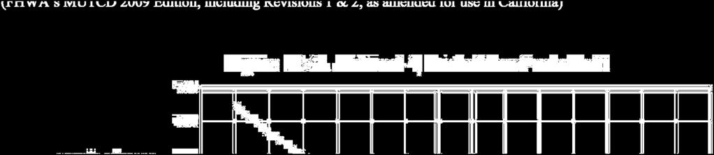
12 City of Sacramento Pedestrian Crossing Guidelines October mph 35 mph 2 Lanes C C 3 Lanes C C 4 or More Lanes with Raised Median 4 or More Lanes o Raised Median C = Candidate sites for marked crosswalks (*). P = Possible candidate sites for marked crosswalks (*). = Marked crosswalks alone are insufficient (*). Table 2: Recommended Pedestrian Crossing Enhancement Treatments for Marked Crosswalks at Uncontrolled Locations 9,000 ADT > 9,000 ADT to 12,000 ADT > 12,000 to 15,000 ADT > 15,000 ADT mph mph mph mph mph mph mph mph mph mph mph mph P (L 1; See ote (1)) Or L 2/L 3 P (L 1; SEE ote (2)) Or L 2/L 3 C C P L 2/L 3 C P G Or L 2 / L 3 (*) = Refer to Exhibit 3 for description of category C, P, and. L 3 L 3 C C C P (G) OR (L 1; See ote (2)) Or L 2/L 3 P L 2/L 3 G = Geometric treatment. L 1, L 2, and, L 3 = Recommended level of pedestrian crossing enhancement treatment; see Table 1 for details. L 2/L 3 P (L 1; See ote (1)) Or L 2/L 3 P (L 1; See ote (2)) Or L 2/L 3 otes: (1) 2-lanes: Possible treatment options using RRFBs: a. 1-lane each direction: 2-RRFB. b. 2-lanes, one-way: 2- RRFB (one on each side of the road). c. If neither (a) or (b) is feasible / applicable, consider L 2 Or L 3. (2) 3 lanes: Possible treatment options using RRFBs: (i). 2- lanes + TWLTL or a raised median: 2-RRFB + Ped Island - if this combination is not feasible, consider L 2 Or L 3. (ii). All other scenarios (for example, 2 - through lanes + a turn pocket; 3- Lanes, one-way) : L 2 Or L 3. L 3 L 3 C P G Or L 2 / L 3 P L 2 / L 3 L 2/L 3 L 2/L 3 L 3 L 3 L 3 L 3 C P G OR (L 1; See ote (2)) Or L 2/L 3 P L 2/L 3 L 2/L 3 C P G OR (L 1; See ote (2)) Or L 2/L 3 P L 2/L 3 L 2/L 3 P (L 1; See ote (1)) Or L 2/L 3 P (L 1; See ote (2)) Or L 2/L 3 L 2/L 3 L 2/L 3 L 3 L 3 L 3 L 3 C P G OR (L 1; See ote (2)) Or L 2/L 3 L 2/L 3 L 3 P (L 1; See ote (1)) Or L 2/L 3 (L 3) L 3 L 3 40 mph L 3 L 3 L 3 L 3 45 mph L 3 L 3 L 3 L 3 Instructions: (1). The design of marked pedestrian crossing facilities at uncontrolled locations should incorporate the following: (a) City of Sacramento s basic treatment required for ALL marked crossings at uncontrolled locations. Refer to Section for details. (b) Pedestrian crossing enhancement treatment(s) the recommended treatment levels corresponding to different site conditions as presented in the above Table; the list of different levels of treatments is presented in Table 1. Refer to Sections and for additional details. (2). The selected treatment / device shall meet the applicable requirements as mentioned in to Table 1 and the corresponding Appendix. (3). These are general recommendations; good engineering judgment should be used in all cases for deciding where to install crosswalks, and what treatment / combination of treatments to install. 83
13 APPEDIX III Pedestrian Crossing Enhancement Treatments for Marked Crosswalks at Uncontrolled Locations
14 City of Sacramento Pedestrian Crossing Guidelines October 2014 Table 1: Pedestrian Crossing Enhancement Treatments for Marked Crosswalks at Uncontrolled Locations (Sheet 1 of 3) CITY OF SACRAMETO S BASIC TREATMET (*) Treatment Placement Requirements, and / or Guidance High visibility marked triple-four crosswalk, and associated signs and pavement word markings. (1) Required for all marked crossings at uncontrolled locations. (2) Refer to Section for details. PRICIPAL TREATMETS (*) Geometric Enhancement Treatments (*) Treatment Placement Requirements, and / or Guidance Raised Median / Pedestrian Median Refuge Island. Split Pedestrian Crossover Median Refuge Island. (1) Where roadway width can accommodate without negatively affecting bicycle and vehicle traffic. (2) Refer to Appendix A1 for further information. (1) Where roadway width can accommodate without negatively affecting bicycle and vehicle traffic. (2) Refer to Appendix A2 for further information. Level 1 Enhancement Treatments (L 1 ) (*) Treatment Placement Requirements, and / or Guidance Rectangular Rapid Flashing Beacon (RRFB) two device treatment. (1) A two-device / a side-mounted RRFB treatment refers to an installation with two RRFBs (one for each direction of an approach mounted at the right-hand side of the approach). (2) The installation of RRFBs shall comply with the FHWA s Conditions of Interim Approval (FHWA IA-11); refer the subject interim approval memo at: (3) For crossings with obstructed visibility for side-mounted RRFB treatment, a median-mounted RRFB treatment (Level 2) or other appropriate treatment, such as Level 3 treatment (see below) shall be considered. (4) Refer to Appendix A3 for further information. (*) OTES: (1) These are general recommendations; good engineering judgment should be used in all situations for deciding where to install crosswalks, and what treatment / combination of treatments to install. (2) The treatments recommended in the guidelines reflect the more common treatments being used and may not include every treatment available. (3) Refer to Section for further information on the recommended treatments. 79
15 City of Sacramento Pedestrian Crossing Guidelines October 2014 Table 1: Pedestrian Crossing Enhancement Treatments for Marked Crosswalks at Uncontrolled Locations (Sheet 2 of 3) Level 2 Enhancement Treatments (L 2 ) (*) Treatment Rectangular Rapid Flashing Beacon (RRFB) four device treatment. Placement Requirements, and / or Guidance (1) A four-device / a median-mounted RRFB treatment refers to an installation of four RRFBs (two per approach with one on the roadway median / island and one on the right-hand side). (2) The installation of RRFBs shall comply with the FHWA s Conditions of Interim Approval (FHWA IA-11); refer the subject interim approval memo at: (3) For locations where a median island RRFB treatment is not feasible, or there are more than two lanes in a direction, other appropriate treatments, such as Level 3 treatments (see below) shall be considered. Alternatively, the RRFBs may be considered for mounting overhead consistent with FHWA s Interpretation Letter regarding RRFB Overhead mounting which is available at: (4) Refer to Appendix A4 for further information. Level 3 Enhancement Treatments (L 3 ) (*) Treatment Placement Requirements, and / or Guidance Pedestrian Hybrid Beacon (PHB) / Highintensity Activated Crosswalk (HAWK). Traffic Signal, where warranted. Grade Separation: Pedestrian Overcrossing or Undercrossing. (1) Refer to CA MUTCD (1), Chapter 4F for applicable requirements, and installation guidance. (2) Refer to Appendix A5 for further information (1) Refer to CA MUTCD (1), Part 4 for applicable traffic signal warrants, and other requirements. (2) It is recommended to install countdown pedestrian signal heads at all traffic signals, except where the pedestrian crossing is prohibited. Section 5.6 describes the conditions that may require pedestrian crossing prohibition. (3) Refer to Section for recommended guidelines for marking crosswalks and limit lines at signalized intersections. (4) Refer to Appendix A6 for further information. (1) According to FHWA study, (10) grade-separated crossings are very expensive and should only be considered in extreme situations, such as where pedestrian crossings are essential (e.g., school children need to cross a six-lane arterial street), street crossing at - grade is not feasible for pedestrians, and no other measures are considered to be appropriate. (2) Refer to Appendix A7 for further information. (*) OTES: (1) These are general recommendations; good engineering judgment should be used in all situations for deciding where to install crosswalks, and what treatment / combination of treatments to install. (2) The treatments recommended in the guidelines reflect the more common treatments being used and may not include every treatment available. (3) Refer to Section for further information on the recommended treatments. 80
 Treatment In-Roadway Warning Lights (IRWLs) Appendix B1. Flashing Warning Beacon Appendix B2. Road Diet (Roadway Reconfiguration) Appendix B3. Curb Extension Appendix B4.")
16 City of Sacramento Pedestrian Crossing Guidelines October 2014 Table 1: Pedestrian Crossing Enhancement Treatments for Marked Crosswalks at Uncontrolled Locations (Sheet 3 of 3) SUPPLEMETAL EHACEMET TREATMETS (*) Treatment In-Roadway Warning Lights (IRWLs) Appendix B1. Flashing Warning Beacon Appendix B2. Road Diet (Roadway Reconfiguration) Appendix B3. Curb Extension Appendix B4. Tighter Curb Return Radii Appendix B5. Improved Right - Turn Slip - Lane Design Appendix B6. Advanced Yield / Stop Lines Appendix B7. Advanced Stop Line / Limit Line at Traffic Signals Appendix B8. In-Street and Overhead Pedestrian Crossing Sign Appendix B9. Pedestrian-Activated Flashing (Embedded LED) Warning Sign Appendix B10. Traffic-calming Measures Appendix B11. Textured Pavement Appendix B12. Eliminate parking on the approach to uncontrolled crosswalks Appendix B13. Locate transit stops on the far side of the intersection Appendix B14. Hardware and Operational Treatments for Signalized Locations Appendixes C1 C10. Suggested Reference for Placement Requirements, and Guidance (*) OTES: (1) These are general recommendations; good engineering judgment should be used in all situations for deciding where to install crosswalks, and what treatment / combination of treatments to install. (2) The treatments recommended in the guidelines reflect the more common treatments being used and may not include every treatment available. (3) Refer to Section for further information on the recommended treatments. 81
17 APPEDIX IV FORECASTED TRAIL VOLUMES
18
19 APPEDIX V TRAFFIC COUT DATA
20 Location: Sutterville Rd Specific Location: Between Mulberry Ln and South Land Park Dr Site Code: 01 Station ID: Date Range: 3/7/2017-3/7/2017 Tuesday Wednesday Thursday Friday Saturday Sunday Monday 3/7/2017 3/8/2017 3/9/2017 3/10/2017 3/11/2017 3/12/2017 3/13/2017 Mid-Week Average Time EB WB Total EB WB Total EB WB Total EB WB Total EB WB Total EB WB Total EB WB Total EB WB Total 12:00 AM :00 AM :00 AM :00 AM :00 AM :00 AM :00 AM :00 AM , ,229 8:00 AM , ,268 9:00 AM :00 AM :00 AM :00 PM , ,233 1:00 PM , ,017 2:00 PM , ,213 3:00 PM , ,325 4:00 PM , ,385 5:00 PM :00 PM :00 PM :00 PM :00 PM :00 PM :00 PM Total 7,631 6,992 14, ,631 6,992 14,623 Percent 52% 48% 100% % 48% 100% AM Peak 8:00 7:15 7: :00 7:15 7:45 Volume , ,323 PM Peak 16:15 15:30 16: :15 15:30 16:00 Volume , , Mid-week average includes data between Tuesday and Thursday. Deon Fouche: (415) deon.fouche@idaxdata.com 1
21 Location: South Land Park Dr Specific Location: Between Parkside Ct and Sutterville Rd Site Code: 02 Station ID: Date Range: 3/7/2017-3/7/2017 Tuesday Wednesday Thursday Friday Saturday Sunday Monday 3/7/2017 3/8/2017 3/9/2017 3/10/2017 3/11/2017 3/12/2017 3/13/2017 Mid-Week Average Time B SB Total B SB Total B SB Total B SB Total B SB Total B SB Total B SB Total B SB Total 12:00 AM :00 AM :00 AM :00 AM :00 AM :00 AM :00 AM :00 AM :00 AM :00 AM :00 AM :00 AM :00 PM :00 PM :00 PM :00 PM :00 PM :00 PM :00 PM :00 PM :00 PM :00 PM :00 PM :00 PM Total 2,358 2,574 4, ,358 2,574 4,932 Percent 48% 52% 100% % 52% 100% AM Peak 7:30 11:45 7: :30 11:45 7:30 Volume PM Peak 16:45 16:45 16: :45 16:45 16:45 Volume Mid-week average includes data between Tuesday and Thursday. Deon Fouche: (415) deon.fouche@idaxdata.com 1
22 Location: Del Rio Rd Specific Location: Between Alta Dr and ormandy Ln Site Code: 03 Station ID: Date Range: 3/7/2017-3/7/2017 Tuesday Wednesday Thursday Friday Saturday Sunday Monday 3/7/2017 3/8/2017 3/9/2017 3/10/2017 3/11/2017 3/12/2017 3/13/2017 Mid-Week Average Time B SB Total B SB Total B SB Total B SB Total B SB Total B SB Total B SB Total B SB Total 12:00 AM :00 AM :00 AM :00 AM :00 AM :00 AM :00 AM :00 AM :00 AM :00 AM :00 AM :00 AM :00 PM :00 PM :00 PM :00 PM :00 PM :00 PM :00 PM :00 PM :00 PM :00 PM :00 PM :00 PM Total 1,077 1,318 2, ,077 1,318 2,395 Percent 45% 55% 100% % 55% 100% AM Peak 7:15 8:15 8: :15 8:15 8:15 Volume PM Peak 15:00 16:30 16: :00 16:30 16:30 Volume Mid-week average includes data between Tuesday and Thursday. Deon Fouche: (415) deon.fouche@idaxdata.com 1
23 Location: Del Rio Rd Specific Location: Between ormandy Ln and 27th Ave Site Code: 04 Station ID: Date Range: 3/7/2017-3/7/2017 Tuesday Wednesday Thursday Friday Saturday Sunday Monday 3/7/2017 3/8/2017 3/9/2017 3/10/2017 3/11/2017 3/12/2017 3/13/2017 Mid-Week Average Time B SB Total B SB Total B SB Total B SB Total B SB Total B SB Total B SB Total B SB Total 12:00 AM :00 AM :00 AM :00 AM :00 AM :00 AM :00 AM :00 AM :00 AM :00 AM :00 AM :00 AM :00 PM :00 PM :00 PM :00 PM :00 PM :00 PM :00 PM :00 PM :00 PM :00 PM :00 PM :00 PM Total , ,665 Percent 46% 54% 100% % 54% 100% AM Peak 8:00 11:45 8: :00 11:45 8:15 Volume PM Peak 14:30 15:15 14: :30 15:15 14:45 Volume Mid-week average includes data between Tuesday and Thursday. Deon Fouche: (415) deon.fouche@idaxdata.com 1
24 Location: 27th Ave Specific Location: Between Del Rio Rd and "The South Curve" Site Code: 05 Station ID: Date Range: 3/7/2017-3/7/2017 Tuesday Wednesday Thursday Friday Saturday Sunday Monday 3/7/2017 3/8/2017 3/9/2017 3/10/2017 3/11/2017 3/12/2017 3/13/2017 Mid-Week Average Time B SB Total B SB Total B SB Total B SB Total B SB Total B SB Total B SB Total B SB Total 12:00 AM :00 AM :00 AM :00 AM :00 AM :00 AM :00 AM :00 AM :00 AM :00 AM :00 AM :00 AM :00 PM :00 PM :00 PM :00 PM :00 PM :00 PM :00 PM :00 PM :00 PM :00 PM :00 PM :00 PM Total , ,339 Percent 48% 52% 100% % 52% 100% AM Peak 8:15 8:15 8: :15 8:15 8:15 Volume PM Peak 15:00 16:15 15: :00 16:15 15:00 Volume Mid-week average includes data between Tuesday and Thursday. Deon Fouche: (415) deon.fouche@idaxdata.com 1
25 Location: Fruitridge Rd Specific Location: Between South Land Park Dr and Gilgunn Way Site Code: 06 Station ID: Date Range: 3/7/2017-3/7/2017 Tuesday Wednesday Thursday Friday Saturday Sunday Monday 3/7/2017 3/8/2017 3/9/2017 3/10/2017 3/11/2017 3/12/2017 3/13/2017 Mid-Week Average Time EB WB Total EB WB Total EB WB Total EB WB Total EB WB Total EB WB Total EB WB Total EB WB Total 12:00 AM :00 AM :00 AM :00 AM :00 AM :00 AM :00 AM :00 AM , ,352 8:00 AM , ,211 9:00 AM :00 AM :00 AM :00 PM , ,051 1:00 PM , ,002 2:00 PM , ,302 3:00 PM , ,432 4:00 PM , ,466 5:00 PM , ,433 6:00 PM , ,020 7:00 PM :00 PM :00 PM :00 PM :00 PM Total 7,995 8,972 16, ,995 8,972 16,967 Percent 47% 53% 100% % 53% 100% AM Peak 7:30 7:15 7: :30 7:15 7:30 Volume , ,501 PM Peak 14:15 16:15 16: :15 16:15 16:15 Volume , , Mid-week average includes data between Tuesday and Thursday. Deon Fouche: (415) deon.fouche@idaxdata.com 1
26 Location: 35th Ave Specific Location: Between 14th St and Park Village St Site Code: 07 Station ID: Date Range: 3/7/2017-3/7/2017 Tuesday Wednesday Thursday Friday Saturday Sunday Monday 3/7/2017 3/8/2017 3/9/2017 3/10/2017 3/11/2017 3/12/2017 3/13/2017 Mid-Week Average Time EB WB Total EB WB Total EB WB Total EB WB Total EB WB Total EB WB Total EB WB Total EB WB Total 12:00 AM :00 AM :00 AM :00 AM :00 AM :00 AM :00 AM :00 AM :00 AM :00 AM :00 AM :00 AM :00 PM :00 PM :00 PM :00 PM :00 PM :00 PM :00 PM :00 PM :00 PM :00 PM :00 PM :00 PM Total 1,725 2,029 3, ,725 2,029 3,754 Percent 46% 54% 100% % 54% 100% AM Peak 7:30 7:30 7: :30 7:30 7:30 Volume PM Peak 14:15 15:15 14: :15 15:15 14:45 Volume Mid-week average includes data between Tuesday and Thursday. Deon Fouche: (415) deon.fouche@idaxdata.com 1

27 Location: 43rd Ave Specific Location: Between 14th St and Park Village St Site Code: 08 Station ID: Date Range: 3/7/2017-3/7/2017 Tuesday Wednesday Thursday Friday Saturday Sunday Monday 3/7/2017 3/8/2017 3/9/2017 3/10/2017 3/11/2017 3/12/2017 3/13/2017 Mid-Week Average Time EB WB Total EB WB Total EB WB Total EB WB Total EB WB Total EB WB Total EB WB Total EB WB Total 12:00 AM :00 AM :00 AM :00 AM :00 AM :00 AM :00 AM :00 AM :00 AM :00 AM :00 AM :00 AM :00 PM :00 PM :00 PM :00 PM :00 PM :00 PM :00 PM :00 PM :00 PM :00 PM :00 PM :00 PM Total 4,443 4,004 8, ,443 4,004 8,447 Percent 53% 47% 100% % 47% 100% AM Peak 7:15 7:30 7: :15 7:30 7:30 Volume PM Peak 14:15 17:15 17: :15 17:15 17:00 Volume Mid-week average includes data between Tuesday and Thursday. Deon Fouche: (415) deon.fouche@idaxdata.com 1
28 APPEDIX VI CITY S EGIEERIG AD TRAFFIC SURVEYS
29 Location o. of Crashes within 250' Speed Limit (10/1/ /1/2016) See attached page # 1 Sutterville Road intersecting with Freeport Boulevard Sutterville Road between Mulberry Lane & South Land Park Drive South Land Park Drive between Parkside Court & Sutterville Road Del Rio Road between Alta Drive & ormandy Lane Del Rio Road intersecting with omandy Lane th Avenue between Del Rio Road & south curve 0 one 7 Fruitridge Road intersecting with Freeport Boulevard Fruitridge Road between South Land Park Drive & Gilgunn Way th Avenue intersecting with Freeport Boulevard th Avenue between 14th Avenue & Park Village Street Blair Avenue intersecting with Freeport Boulevard rd Avenue between 14th Avenue & Park Village Street Florin Road intersecting with Freeport Boulevard & Florin Road between South Land Park Drive & Freeport Boulevard & Pocket Road/Meadowview Road intersecting with Freeport Boulevard & Pocket Road between Alma Vista Way & Freeport Boulevard Water Utilities Site Driveway intersecting with Freeport Boulevard 1 one Del Rio Trail Data Summary - Updates by MB Speed Limits, Crash Data Updated: 3/2/2017
30
31
32
33
34
35
36
37 APPEDIX VII TRAFFIC SIGAL WARRAT AALYSIS

38
39
40
41

42


43
44 APPEDIX VIII WARRAT FOR THREE-WAY STOP SIG LOCATIOS
45 WARRATS FOR THREE WAY STOP SIG LOCATIOS LOACATIOS WITH LESS THA 10,000 VEHICLES PER DAY O THE THROUGH STREET Three way stop signs may be considered at locations meeting all warrants (A D) and one or more of warrants (1 3) 27 TH Avenue Del Rio Rd THROUGH STREET MIOR STREET A. A minimum uncontrolled approach distance on the through street of 750 feet from a stop or 1000 feet from a traffic signal. B. Posted speed on the through street is 35 MPH or less. C. Three way stops shall only be placed on two lane facilities. D. A minimum of 25% of traffic is exceeding the speed limit on the through street. VOLUME 1. The total volume entering the intersection from all approaches is a minimum of 150 units per hour for any two hours of an average day and the traffic volume entering the intersection from the through street compared to the minor street for the same two hours has a ratio of 10:1 or less. The volume of pedestrians* and bicyclists crossing the through street shall be added to the minor street volume. YES O * Pedestrians shall be counted as 1.5 units. Children, elderly, and disabled shall count as 2.0 units. ACCIDETS 2. There are three or more accidents within a 12 month period, susceptible to correction by the installation of stop signs. VISIBILITY** 3. The sight distance from the stopped minor leg is less than the following: California State Highway Design Manual Corner Sight Distance THROUGH STREET SPEED (MPH) DISTACE (FT) ** Only after less restrictive measures are unsuccessful, e.g., parking removal, etc. OTES: COUCIL DISTRICT ITERSECTIO QUALIFIES YES O IVESTIGATOR DATE
46 APPEDIX IX SYCHRO REPORT
47 HCM Unsignalized Intersection Capacity Analysis Existing AM Peak Hour 3: Del Rio Rd & 27th Ave 07/12/2017 Movement EBL EBR BL BT SBT SBR Lane Configurations Traffic Volume (veh/h) Future Volume (Veh/h) Sign Control Stop Free Free Grade 0% 0% 0% Peak Hour Factor Hourly flow rate (vph) Pedestrians 16 Lane Width (ft) 12.0 Walking Speed (ft/s) 3.5 Percent Blockage 2 Right turn flare (veh) Median type one one Median storage veh) Upstream signal (ft) px, platoon unblocked vc, conflicting volume vc1, stage 1 conf vol vc2, stage 2 conf vol vcu, unblocked vol tc, single (s) tc, 2 stage (s) tf (s) p0 queue free % cm capacity (veh/h) Direction, Lane # EB 1 B 1 SB 1 Volume Total Volume Left Volume Right csh Volume to Capacity Queue Length 95th (ft) Control Delay (s) Lane LOS A A Approach Delay (s) Approach LOS A Intersection Summary Average Delay 3.6 Intersection Capacity Utilization 17.5% ICU Level of Service A Analysis Period (min) 15 07/12/2017 Baseline Synchro 9 Report Page 1
48 HCM Unsignalized Intersection Capacity Analysis Existing + Project AM Peak Hour 3: Del Rio Rd & 27th Ave 07/12/2017 Movement EBL EBR BL BT SBT SBR Lane Configurations Sign Control Stop Stop Stop Traffic Volume (vph) Future Volume (vph) Peak Hour Factor Hourly flow rate (vph) Direction, Lane # EB 1 B 1 SB 1 Volume Total (vph) Volume Left (vph) Volume Right (vph) Hadj (s) Departure Headway (s) Degree Utilization, x Capacity (veh/h) Control Delay (s) Approach Delay (s) Approach LOS A A A Intersection Summary Delay 7.2 Level of Service A Intersection Capacity Utilization 17.5% ICU Level of Service A Analysis Period (min) 15 07/12/2017 Baseline Synchro 9 Report Page 1
MEMORANDUM. Bob Zagozda, Chief Financial Officer Westside Community Schools. Mark Meisinger, PE, PTOE Felsburg Holt & Ullevig. DATE: June 11, 2018
 MEMORANDUM TO: Bob Zagozda, Chief Financial Officer Westside Community Schools FROM: Mark Meisinger, PE, PTOE Felsburg Holt & Ullevig DATE: June 11, 218 6-11-18 SUBJECT: Sunset Hills Elementary School
LUDWIG RD. SUBDIVISION PROJECT TRAFFIC IMPACT ANALYSIS
 LUDWIG RD. SUBDIVISION PROJECT TRAFFIC IMPACT ANALYSIS Prepared for Skip Coddington GSC Development, Inc PO Box 1623 Woodinville WA 9872 Prepared by 1141 NE 124 th St., #59 Kirkland, WA 9834 425.522.4118
Aldridge Transportation Consultants, LLC Advanced Transportation Planning and Traffic Engineering
 Aldridge Transportation Consultants, LLC Advanced Transportation Planning and Traffic Engineering John M.W. Aldridge, PE, PTOE, AICP 182 Chimney Rock Road Colorado Registered Professional Engineer Highlands
Attachment No. 20 RRLRT No. 1. Committee. Busway Grade Crossings STATUS/DATE OF ACTION
 Attachment No. 20 RRLRT No. 1 TECHNICAL COMMITTEE: Railroad / Light Rail Transit Technical Committee TOPIC: Busway Grade Crossings STATUS/DATE OF ACTION RRLRT TC Draft: 06/23/2011 RRLRT TC Approval: 06/27/2014
TABLE OF CONTENTS. Coral Springs Charter High School and Middle School Job No Page 2
 Job No. 15-019 Page 2 TABLE OF CONTENTS 1.0 INTRODUCTION... 4 2.0 EXISTING CONDITIONS... 5 3.0 TRAFFIC GENERATION... 7 4.0 TRIP DISTRIBUTION... 8 5.0 FUTURE CONDITIONS... 8 6.0 SITE ACCESS...13 7.0 CONCLUSION...13
Pedestrian Safety Review Spadina Avenue
 STAFF REPORT ACTION REQUIRED Pedestrian Safety Review Spadina Avenue Date: October 13, 2015 To: Toronto and East York Community Council From: Director, Transportation Services, Toronto and East York District
Washington St. & Ash Coulee Dr./43 rd Ave Intersection Study
 430 IACC Building Fargo, ND 58105 Tel 701-231-8058 Fax 701-231-1945 www.ugpti.org www.atacenter.org Washington St. & Ash Coulee Dr./43 rd Ave Intersection Study Final Report April 2007 Prepared for: City
MEMORANDUM. Lynn Hayes LSA Associates, Inc.
 MEMORANDUM To: Lynn Hayes LSA Associates, Inc. Date: May 5, 217 From: Zawwar Saiyed, P.E., Senior Transportation Engineer Justin Tucker, Transportation Engineer I Linscott, Law & Greenspan, Engineers LLG
Lake Erie Commerce Center Traffic Analysis
 LOCATION: East of NYS Route 5 at Bayview Road Town of Hamburg Erie County, New York PREPARED BY: Wendel Companies 140 John James Audubon Parkway Suite 200 Amherst, New York 14228 January 2012 i ii Table
APPENDIX H MILESTONE 2 TRAFFIC OPERATIONS ANALYSIS OF THE AT-GRADE CROSSINGS
 Draft Environmental Impact Statement/Environment Impact Report Appendix H Milestone 2 Traffic Operations Analysis of the At-Grade Crossings APPENDIX H MILESTONE 2 TRAFFIC OPERATIONS ANALYSIS OF THE AT-GRADE
DOGWOOD AT VILLA AVENUE PROJECT
 TRANSPORTATION IMPACT ANALYSIS DOGWOOD AT VILLA AVENUE PROJECT El Centro, California September 4, 2018 LLG Ref. 3-17-2782 TABLE OF CONTENTS SECTION PAGE Appendices... ii List of Figures... i List of Tables...
A. CONCLUSIONS OF THE FGEIS
 Chapter 11: Traffic and Parking A. CONCLUSIONS OF THE FGEIS The FGEIS found that the Approved Plan will generate a substantial volume of vehicular and pedestrian activity, including an estimated 1,300
APPENDIX J TRAFFIC AND PARKING DEMAND STUDIES
 APPENDIX J TRAFFIC AND PARKING DEMAND STUDIES Table of Contents Executive Summary... iv 1.0 Introduction... 1 2.0 Traffic Analysis Methodology and Significance Criteria... 4 2.1 Study Area Criteria...
Planning. Proposed Development at the Southeast Corner of Lakeshore Road West and Brookfield Road Intersection FINAL.
 Project No. 121-22908 N o v e m b e r 2 0 1 2 Traffic Impact Study Transportation Planning th GENIVAR Inc., 600 Cochrane Drive, 5 Floor, Markham, Ontario L3R 5K3 Telephone: 905.475.7270 Fax: 905.475.5994
COMMENT PERIOD INTRODUCTION
 To: Interested Persons From: Tom Buford File: Del Rio Trail Project Date: June 8, 2018 Community Development Department Reference: NOTICE OF PREPARATION OF AN ENVIRONMENTAL IMPACT REPORT FOR THE DEL RIO
Southern Oregon Transportation Engineering, LLC
 Southern Oregon Transportation Engineering, LLC 112 Monterey Drive - Medford, Or. 97504 Office 541.608.9923 Cell 541.941.4148 Email: Kwkp1@Q.com August 12, 2013 Mike Faught, Public Works Department City
Caliber Charter School VALLEJO, CA
 Traffic Impact Study Final Report Caliber Charter School VALLEJO, CA 21 June 2016 Prepared for: Prepared by: Traffic Engineering & Transportation Planning This report has been prepared and certified by
Memorandum. Roger Millar, Secretary of Transportation. Date: April 5, Interstate 90 Operations and Mercer Island Mobility
 Memorandum To: From: The Honorable Dow Constantine, King County Executive; The Honorable Ed Murray, City of Seattle Mayor; The Honorable Bruce Bassett, City of Mercer Island Mayor; The Honorable John Stokes,
Traffic Analysis Final Report
 SR-71 Widening Project Project Approval/Environmental Documentation Traffic Analysis Final Report Prepared for Caltrans District 7 August 2012 6 Hutton Centre Drive, Suite 700 Santa Ana, California 92707
Interstate 90 and Mercer Island Mobility Study APRIL Commissioned by. Prepared by
 Interstate 90 and Mercer Island Mobility Study APRIL 2017 Commissioned by Prepared by Interstate 90 and Mercer Island Mobility Study Commissioned by: Sound Transit Prepared by: April 2017 Contents Section
London Borough of Barnet Traffic & Development Design Team
 London Borough of Barnet Traffic & Development Design Team AERODROME ROAD PEDESTRIAN FACILITY AND BUS STOP INTRODUCTION FEASIBILITY REPORT Job Number: 60668 Doc Ref: S106/12-13/60668 Author: Manoj Kalair
Freymond Aggregates Quarry 2287 Bay Lake Road Twp. of Faraday, Hastings County
 Freymond Aggregates Quarry 2287 Bay Lake Road Twp. of Faraday, Hastings County Traffic Impact Study Prepared by: Tranplan Associates PO Box 455 Lakefield, ON K0L 2H0 www.tranplan.com Prepared for: Freymond
Provincial Railway Technical Standards
 GENERAL: INDEX: The standards and requirements listed in this document are intended for use on provincially regulated railway public grade crossings. These standards are considered the minimum requirements
EXISTING CONDITIONS A. INTRODUCTION. Route 107 Corridor Study Report
 II. EXISTING CONDITIONS A. INTRODUCTION The Route 107 study area extends from the south at Chestnut Street in Lynn approximately 3.7 miles to the north to Boston Street in Salem. The study area has three
4. Safety Concerns Potential Short and Medium-Term Improvements
 NH Route 104 Access Management Study Page 19 4. Safety Concerns Potential Short and Medium-Term Improvements Potential safety improvement strategies are listed by priority based on field observations by
Community Advisory Panel Meeting #
 Community Advisory Panel Meeting # 6 02.13.19.. Agenda Welcome and Introductions Community Conversations City Council Meeting Debrief Review Citywide Tunnel Video (North Portal Only) Churchill Pedestrian
STAR Bond Development
 STR ond Development Traffic Impact Study Goddard, Kansas Prepared for: Kansas Department of Transportation City of Goddard, Kansas Prepared by TranSystems November 218 November 3, 218 Kansas Department
1.2 Corridor History and Current Characteristics
 SECTION 1 Description and Background of Study Area 1.1 Introduction This preliminary engineering report was prepared for the Alaska Department of Transportation and Public Facilities (ADOT&PF). It is part
FINAL TERMINAL TRAFFIC MONITORING STUDY
 FINAL TERMINAL 91 216 TRAFFIC MONITORING STUDY Prepared for: Port of Seattle February 15, 217 Prepared by: 12131 113 th Avenue NE, Suite 23 Kirkland, WA 9834-712 Phone: 425-821-3665 www.transpogroup.com
NCUTCD Proposal for Changes to the Manual on Uniform Traffic Control Devices
 1 2 3 4 5 6 7 8 9 10 11 12 13 14 15 16 17 18 19 20 21 22 23 24 25 26 27 28 29 30 31 32 TECHNICAL COMMITTEE: ITEM NUMBER: TOPIC: ORIGIN OF REQUEST: AFFECTED SECTIONS OF MUTCD: NCUTCD Proposal for Changes
PURPOSE AND NEED (CONCURRENCE POINT 1) NEW CANADA ROAD PROJECT FROM STATE ROUTE 1 (U.S. HIGHWAY 70) TO U.S. INTERSTATE 40
 NEW CANADA ROAD PROJECT FROM STATE ROUTE 1 (U.S. HIGHWAY 70) TO U.S. INTERSTATE 40") PURPOSE AND NEED (CONCURRENCE POINT 1) NEW CANADA ROAD PROJECT FROM STATE ROUTE 1 (U.S. HIGHWAY 70) TO U.S. INTERSTATE 40 Project Description The primary purpose of this project is to improve the major
PURPOSE AND NEED (CONCURRENCE POINT 1) NEW CANADA ROAD PROJECT FROM STATE ROUTE 1 (U.S. HIGHWAY 70) TO U.S. INTERSTATE 40 Project Description The primary purpose of this project is to improve the major
Fairfax County Parkway Widening Fairfax County
 Get Involved VDOT representatives will review and evaluate information received as a result of this meeting. Please fill out the comment sheet provided in this brochure if you have any comments or questions.
Proposed Bicycle Lanes on Yonge Street from Queens Quay to Front Street
 STAFF REPORT ACTION REQUIRED Proposed Bicycle Lanes on Yonge Street from Queens Quay to Front Street Date: March 12, 2007 To: From: Toronto and East York Community Council Director, Transportation Infrastructure
Treasure Island Supplemental Information Report Addendum
 1 1 1 1 0 1 0 1 0 1 Treasure Island Supplemental Information Report Addendum Introduction Purpose The purpose of this Supplemental Information Report (SIR) Addendum is to determine if the current land
HIGHWAY RAIL GRADE CROSSING CONSOLIDATION PROGRAM
 HIGHWAY RAIL GRADE CROSSING CONSOLIDATION PROGRAM To decrease unnecessary train traffic exposure to life and property, promote public safety, and improve traffic conditions, the Texas Department of Transportation
TRAFFIC CONTROL DEVICES MANUAL FOR WORK ZONES
 TRAFFIC CONTROL DEVICES MANUAL FOR WORK ZONES SUMMARY Work zone activities often create conditions on the travelled way that are hazardous particularly at night when the ability of motorists to see is
SAN FRANCISCO MUNICIPAL TRANSPORTATION AGENCY BOARD OF DIRECTORS. RESOLUTION No
 SAN FRANCISCO MUNICIPAL TRANSPORTATION AGENCY BOARD OF DIRECTORS RESOLUTION No. 16-145 WHEREAS, The San Francisco Municipal Transportation Agency has proposed parking and traffic on San Bruno Avenue included
RAILROAD QUIET ZONE PROJECT
 RAILROAD QUIET ZONE PROJECT VILLAGE OF ROSELLE Village of Roselle 31 S. Prospect Street Roselle, IL 60172 9575 WEST HIGGINS ROAD, SUITE 600 ROSEMONT, IL 60018 TEL. (847) 823-0500 FAX (847) 823-0520 Table
Alternatives Analysis City of Newport Beach Sunset Ridge Park Project December 14, 2011
 Alternatives Analysis City of Newport Beach Sunset Ridge Park Project December 14, 2011 Alternatives Analysis for Vehicular Access: This report supplements the project s certified EIR s Alternatives Analysis.
COUNTY OF SACRAMENTO CALIFORNIA
 COUNTY OF SACRAMENTO CALIFORNIA For the Agenda of: June 22, 2017 To: From: Subject: Supervisorial District: Contact: Recreation and Park Commission Department of Regional Parks Off Paved Trail Cycling
Western Development Lands Transportation Brief Richmond Village, (Ottawa), ON Mattamy Homes. Prepared By: Stantec Consulting Ltd.
, ON Mattamy Homes. Prepared By: Stantec Consulting Ltd.") Western Development Lands Transportation Brief Richmond Village, (Ottawa), ON Mattamy Homes Prepared By: Stantec Consulting Ltd. March 2012 RICHMOND VILLAGE, OTTAWA, ON TRANSPORTATION BRIEF APRIL 2013
Western Development Lands Transportation Brief Richmond Village, (Ottawa), ON Mattamy Homes Prepared By: Stantec Consulting Ltd. March 2012 RICHMOND VILLAGE, OTTAWA, ON TRANSPORTATION BRIEF APRIL 2013
SAN FRANCISCO MUNICIPAL TRANSPORTATION AGENCY
 THIS PRINT COVERS CALENDAR ITEM NO. : 10.4 DIVISION: Sustainable Streets BRIEF DESCRIPTION: SAN FRANCISCO MUNICIPAL TRANSPORTATION AGENCY Approving various parking and traffic modifications associated
TRAFFIC IMPACT STUDY REPORT FOR PROPOSED OFFICE PROJECT AT 959 SEWARD STREET IN HOLLYWOOD SNYDER PARTNERS
 DRAFT TRAFFIC IMPACT STUDY REPORT FOR PROPOSED OFFICE PROJECT AT 959 SEWARD STREET IN HOLLYWOOD Prepared for: SNYDER PARTNERS Prepared by: Crain & Associates 2007 Sawtelle Boulevard, Suite 4 Los Angeles,
Parking Amendments - Bay Street, between Harbour Street and Queens Quay West (York Street, Bay Street, and Yonge Street Ramp Removal)
") REPORT FOR ACTION between Harbour Street and Queens Quay West (York Street, Bay Street, and Yonge Street Ramp Removal) Date: October 26, 2017 To: Toronto and East York Community Council From: Acting Director,
REPORT FOR ACTION between Harbour Street and Queens Quay West (York Street, Bay Street, and Yonge Street Ramp Removal) Date: October 26, 2017 To: Toronto and East York Community Council From: Acting Director,
10.0 Recommendations Methodology Assumptions
 10.0 Recommendations To accommodate the projected growth of the I-526 corridor, this report has summarized potential improvement strategies that were separated into four categories, TDM, Modal, Traffic
FINAL REPORT INTERSECTION STUDY
 FINL REPORT INTERSECTION STUDY Vermont Route 22 & Panton Road City of Vergennes, Vermont May 9, 2011 Prepared for: 14 Seminary Street Middlebury, Vermont 05753 Prepared by: LMOUREUX & DICKINSON 14 Morse
TRANSPORTATION ELEMENT
 Transportation TRANSPORTATION ELEMENT Data, Inventory, and Analysis Prepared by Contents 1.0 INTRODUCTION... 1 2.0 EXISTING CONDITIONS... 1 2.1 Roadways... 1 2.1.1 Jurisdiction... 1 2.1.2 Functional Classification...
Section 106 Update Memo #1 Attachment D. Traffic Diversion & APE Expansion Methodology & Maps
 Section 106 Update Memo #1 Attachment D Traffic Diversion & APE Expansion Methodology & Maps I-65/I-70 North Split Interchange Reconstruction Project (Des. Nos. 1592385 & 1600808) Traffic Diversion and
FEASIBILITY STUDY REFINED CONCEPT 1 PROJECT A
 VIRGINIA DEPARTMENT OF TRANSPORTATION I-85 / I-95 INTERCHANGE FEASIBILITY STUDY REFINED CONCEPT 1 PROJECT A Columbia Rd REFINED CONCEPT 1 PROJECT A Bellevue Rd COST: $3.3M Siege Rd Eliminate the loop ramp
The Baker/Carver Regional Trail is intended to
 Section V Design Guidance The Baker/Carver Regional Trail is intended to safely accommodate 183,000 annual visits, an array of non-motorized uses, a variety of skill levels, and persons with special needs.
Memorandum. To: From: cc: Date: November 7, Re: 1.0 Purpose and Organization of this Addendum. 2.0 Project Description
 Memorandum To: From: cc: Laura Prickett, Horizon Water and Environment Analette Ochoa and Wana Chiu, WRECO Parag Mehta, Kimley Horn Date: November 7, 2017 Re: Santa Cruz Route 1 Tier I and Tier II HOV
This report was prepared by the Lake Zurich Police Department Traffic Safety Division. Intersection location and RLR camera approaches identified:
 POLICE DEPARTMENT 200 Mohawk Trail Lake Zurich, Illinois 60047 (847) 719-1690 LakeZurich.org April 1, 2018 This report is being submitted regarding the red-light cameras. According to the Red Light Running
# 7. Date of Meeting: September 2, 2015 BOARD OF SUPERVISORS BUSINESS MEETING ACTION ITEM SUBJECT:
 BOARD OF SUPERVISORS BUSINESS MEETING ACTION ITEM Date of Meeting: September 2, 2015 # 7 SUBJECT: ELECTION DISTRICT: CRITICAL ACTION DATE: STAFF CONTACTS: Traffic Congestion and Safety Improvements at
St. Dennis Drive Conversion of Traffic Lanes to On- Street Parking and Bicycle Lanes
 STAFF REPORT ACTION REQUIRED St. Dennis Drive Conversion of Traffic s to On- Street Parking and Bicycle s Date: April 22, 2014 To: From: Wards: Reference Number: Public Works and Infrastructure Committee
MEMORANDUM. ~Department. TO: District Engineers DATE: February 3,2012. Texas. Carol T. Rawson, P.E., Director ~ t~ Pt Traffic Operations Division C /"
 Texas ~Department _ of Transportation MEMORANDUM TO: District Engineers DATE: February 3,2012 FROM: Carol T. Rawson, P.E., Director ~ t~ Pt Traffic Operations Division C /" SUBJECT: Traffic Control Plan
This section evaluates the projected traffic operations and circulation impacts associated with the proposed upgrade and expansion of the LWRP.
 4.5 TRAFFIC AND CIRCULATION This section evaluates the projected traffic operations and circulation impacts associated with the proposed upgrade and expansion of the LWRP. 4.5.1 Environmental Setting Existing
Glasgow Street Traffic Review
 Glasgow Street Traffic Review Recommendation That the Standing Policy Committee on Transportation recommend to City Council: 1. That the Administration proceed with removing the pinch points installed
PART 8. TRAFFIC CONTROLS FOR HIGHWAY-RAIL GRADE CROSSINGS TABLE OF CONTENTS
 Part 8. Traffic Controls for Highway-Rail Grade Crossings Page 8TC-1 PART 8. TRAFFIC CONTROLS FOR HIGHWAY-RAIL GRADE CROSSINGS TABLE OF CONTENTS Page CHAPTER 8A. GENERAL...........................................
Michigan s Engineering Safety Program for Local Roadways
 Michigan s Engineering Safety Program for Local Roadways Local Road Safety Peer Exchange October 2018 Timothy J. Gates, Ph.D., P.E., P.T.O.E. Michigan State University Andrew Ceifetz, P.E. WSP For More
 Appendix H1 Traffic Study Hill St Obispo Ave Obispo Ave Student Drop-off & Pick-up Area Parking Lot Plaza Level Hill St Fire Lane Access Service Lane Access Redondo Ave Redondo Ave Parking Lot N No
Downtown Skokie & Oakton Street Corridor Study (Draft)
") Downtown Skokie & Oakton Street Corridor Study (Draft) Skokie, Illinois Project Manager: William C. Grieve, P.E., PTOE GHA Project #3261.805 Downtown Skokie & Oakton Street Corridor Study Skokie, Illinois
Downtown Skokie & Oakton Street Corridor Study (Draft) Skokie, Illinois Project Manager: William C. Grieve, P.E., PTOE GHA Project #3261.805 Downtown Skokie & Oakton Street Corridor Study Skokie, Illinois
Madison Metro Transit System
 Madison Metro Transit System 1101 East Washington Avenue Madison, Wisconsin, 53703 Administrative Office: 608 266 4904 Fax: 608 267 8778 TO: FROM: SUBJECT: Plan Commission Timothy Sobota, Transit Planner,
ROUTE 122 CORRIDOR STUDY ---- Bedford County and Bedford City, Virginia
 ROUTE 122 CORRIDOR STUDY ---- Bedford County and Bedford City, Virginia Developed by Region 2000 Regional Commission In cooperation with Bedford County, Virginia City of Bedford, Virginia Virginia Department
Sky Temporary Car Park Transport Statement
 001 Issue 26 August 2016 This report takes into account the particular instructions and requirements of our client. It is not intended for and should not be relied upon by any third party and no responsibility
Longmont to Boulder Regional Trail Jay Road Connection DRAFT FINAL REPORT
 Longmont to Boulder Regional Trail Jay Road Connection DRAFT FINAL REPORT December 2018 Project Summary Boulder County, Colorado, in partnership with the City of Boulder, is evaluating options for multi-use
ROUTE 20 CORRIDOR STUDY ---- Orange County, Virginia
 ROUTE 20 CORRIDOR STUDY ---- Orange County, Virginia Prepared by PARSONS Fairfax, Virginia on behalf of the: Rappahannock-Rapidan Regional Commission in cooperation with Orange County, Virginia Virginia
Level Crossings Configuration Standards
 Discipline: Engineering (Track & Civil) Category: Standard Level Crossings Configuration Standards ETD-16-04 Applicability New South Wales CRIA (NSW CRN) Primary Source ARTC NSW Standard XDS 01 Document
2008 DEKALB COUNTY TRANSPORTATION PLAN (UPDATE)
") 2008 DEKALB COUNTY TRANSPORTATION PLAN (UPDATE) TABLE OF CONTENTS Introduction 1 Transportation Planning Activities 2 Identification of Problem Areas and Recommended Solutions 7 DeKalb County Projects
2008 DEKALB COUNTY TRANSPORTATION PLAN (UPDATE) TABLE OF CONTENTS Introduction 1 Transportation Planning Activities 2 Identification of Problem Areas and Recommended Solutions 7 DeKalb County Projects
Traffic Management Plan 2018
 Traffic Management Plan 2018 Jesuit College Preparatory School of Dallas Amendment to Planned Development No. 353 Dallas, Texas June 6, 2018 Prepared for Jesuit College Preparatory School of Dallas Prepared
5.1 Traffic and Transportation
 5.1 When it opens in 2009, the Bellevue Nickel Improvement Project will increase the number of vehicles able to travel through the study area, improve travel speeds, and improve safety by reducing the
Railway-Highway Crossing at Grade Regulations: Guidelines for British Columbia s Provincial Heritage Railways
 Railway-Highway Crossing at Grade Regulations: Guidelines for British Columbia s Provincial Heritage Railways SHORT TITLE 1. These Guidelines may be cited as the Railway-Highway Crossing at Grade Guidelines.
Texas Transportation Institute The Texas A&M University System College Station, Texas
 1. Report No. FHWA/TX-05/0-4434-P1 2. Government Accession No. 3. Recipient's Catalog No. 4. Title and Subtitle GUIDANCE FOR FUTURE DESIGN OF FREEWAYS WITH HIGH- OCCUPANCY VEHICLE (HOV) LANES BASED ON
SANTA CLARA COUNTY I-280 CORRIDOR STUDY
 SANTA CLARA COUNTY I-280 CORRIDOR STUDY Appendix B 2 Technical Memorandum Existing Transportation Condition Memo SANTA CLARA VALLEY TRANSPORTATION AUTHORITY (VTA) 1-1 Introduction The I-280 Corridor Study
SECTION 6 - SEPARATION STANDARDS
 SECTION 6 - SEPARATION STANDARDS CHAPTER 1 - PROVISION OF STANDARD SEPARATION 1.1 Standard vertical or horizontal separation shall be provided between: a) All flights in Class A airspace. b) IFR flights
Becker County Trail Routing Feasibility Study
 2016 Becker County Trail Routing Feasibility Study CONNECTING DETROIT MOUNTAIN AND MOUNTAIN VIEW RECREATIONAL AREA TO THE HEARTLAND TRAIL BECKER COUNTY ULTEIG ENGINEERS Contents Acknowledgements...2 INTRODUCTION...3
1.0 Purpose and Organization of the Community Impact Assessment Addendum
 Memorandum To: From: cc: Laura Prickett, Horizon Water and Environment Carie Montero, Senior Project Manager/Environmental Lead, Parsons Transportation Group Parag Mehta, Kimley Horn Date: September 24,
7272 WISCONSIN AVENUE LOCAL AREA TRANSPORTATION REVIEW
 7272 LOCAL AREA TRANSPORTATION REVIEW AND TRANSPORTATION POLICY AREA REVIEW MONTGOMERY COUNTY, MARYLAND Submitted on behalf of Carr Properties Prepared by: Wells + Associates, Inc. Submission: July 1,
Site Location and Setting
 Memorandum Date: To: From: Subject: Kristy Le, Gary Black Steve Orem Santa Teresa County Park Historic Area Traffic and Parking Study Hexagon Transportation Consultants, Inc. has completed a traffic and
MEMORANDUM. Open Section Background. I-66 Open Section Study Area. VDOT Northern Virginia District. I-66 Project Team. Date: November 5, 2015
 MEMORANDUM To: VDOT Northern Virginia District From: I-66 Project Team Date: November 5, 2015 Subject: Open Section Background The purpose of this technical memorandum is to provide narrative and technical
Honorable Members of the Mobility Solutions, Infrastructure and Sustainability Committee
 Memorandum DATE August 10, 2018 CITY OF DALLAS TO Honorable Members of the Mobility Solutions, Infrastructure and Sustainability Committee SUBJECT Dallas Love Field Master Plan Update On Monday, August
HDR itrans Consulting Inc. 100 York Blvd., Suite 300 Richmond Hill, ON L4B 1J8 Tel: (905) Fax: (905)
 Fax: (905)") !" # $ !" # $ Consulting Inc. 100 York Blvd., Suite 300 Richmond Hill, ON L4B 1J8 Tel: (905) 882-4100 Fax: (905) 882-1557 www.itransconsulting.com November 2009 %&'('$&$ 1. West Brampton Road Network...
!" # $ !" # $ Consulting Inc. 100 York Blvd., Suite 300 Richmond Hill, ON L4B 1J8 Tel: (905) 882-4100 Fax: (905) 882-1557 www.itransconsulting.com November 2009 %&'('$&$ 1. West Brampton Road Network...
FEASIBILITY CRITERIA
 This chapter describes the methodology and criteria used to evaluate the feasibility of developing trails throughout the study areas. Land availability, habitat sensitivity, roadway crossings and on-street
Appendix B Connecting Track Options Evaluation Criteria
 Appendix B Connecting Track Options Evaluation Criteria 608979-853_ra_July5-0_App Title Pages.Docx TTC ASHBRIDGES BAY MAINTENANCE AND STORAGE FACILITY CONNECTING TRACK ROUTE ALTERNATIVE - EVAULATION MATRIX.0
K SIGNAGE & TRAFFIC CONTROL. Table of Contents
 Table of Contents K1. ACCOMMODATION OF TRAFFIC... 1 K2. MINIMUM CONSTRUCTION SIGNING... 1 K3. SUBDIVISION SIGNS... 2 K4. TRAFFIC CONTROL DEVICES... 2 K4.1 Traffic Signs Regulations... 2 K4.2 Materials...
Hospital Link Project Project Update Winter 2018
 Hospital Link Project Project Update Winter 2018 General The project provides a link from Riverside Drive and the Transitway to the Hospital Link Road. Construction of the Hospital Link facility is open
INTERSTATE 395 EXPRESS LANES NORTHERN EXTENSION TRAFFIC & TRANSPORTATION TECHNICAL REPORT SEPTEMBER 2016
 INTERSTATE 395 EXPRESS LANES NORTHERN EXTENSION TRAFFIC & TRANSPORTATION TECHNICAL REPORT SEPTEMBER 2016 INTERSTATE 395 EXPRESS LANES NORTHERN EXTENSION Traffic and Transportation Technical Report City
District 3 ITS Project Update
 District 3 ITS Project Update Chad Williams, P.E. District 3 ITS Engineer Key ITS Projects in District 3 Bay County Advanced Traffic Management System (ATMS) Okaloosa County Computerized Traffic Control
Transport Impact Assessment
 Transport Impact Assessment Springbok Hotel Erf 5206, Springbok Northern Cape March 2018 5th Floor Imperial Terraces Carl Cronje Drive Tyger Waterfront Bellville, 7530 (021) 914 6211 (T) e mail: mail@itsglobal.co.za
AGENDA. MONTEBELLO TRAFFIC & SAFETY COMMISSION December 6, :00 P.M. City Council Chambers, 1600 W. Beverly Boulevard COMMISSION MEMBERS
 AGENDA MONTEBELLO TRAFFIC & SAFETY COMMISSION December 6, 2017 6:00 P.M. City Council Chambers, 1600 W. Beverly Boulevard COMMISSION MEMBERS RICK KLEMUNDT CHAIRPERSON MIKE TORRES VICE-CHAIRPERSON MICHAEL
APPENDIX J MODIFICATIONS PERFORMED TO THE TOR
 APPENDIX J MODIFICATIONS PERFORMED TO THE TOR This appendix summarizes the modifications that were performed in years 2012 and 2017 to rectify calculation errors that were observed in the data presented
SR 934 Project Development And Environment (PD&E) Study
 Study") SR 934 Project Development And Environment (PD&E) Study Project Advisory Group Meeting March 1, 2018 State Road 934/NE/NW 79th Street from west of I-95 (NW 13th CT) to N. Bayshore Drive PD&E STUDY SR 934/NE/NW
SR 934 Project Development And Environment (PD&E) Study Project Advisory Group Meeting March 1, 2018 State Road 934/NE/NW 79th Street from west of I-95 (NW 13th CT) to N. Bayshore Drive PD&E STUDY SR 934/NE/NW
12, 14 and 16 York Street - Amendments to Section 16 Agreement and Road Closure Authorization
 REPORT FOR ACTION 12, 14 and 16 York Street - Amendments to Section 16 Agreement and Road Closure Authorization Date: April 27, 2018 To: Toronto and East York Community Council From: Senior Strategic Director,
Appendix B Ultimate Airport Capacity and Delay Simulation Modeling Analysis
 Appendix B ULTIMATE AIRPORT CAPACITY & DELAY SIMULATION MODELING ANALYSIS B TABLE OF CONTENTS EXHIBITS TABLES B.1 Introduction... 1 B.2 Simulation Modeling Assumption and Methodology... 4 B.2.1 Runway
Watts St westbound thru
 Executive Summary At the request of the Hudson Square Business Improvement District, Sam Schwartz Engineering, DPC (Sam Schwartz) has completed a technical analysis of various congestion pricing and/or
Claremont Project Background and Update Community Meeting September 11, 2017
 Claremont Project Background and Update Community Meeting September 11, 2017 Topics Project Background Claremont Segment Information Project Timeline Upcoming Discussion Items Upcoming Meetings Questions
Regulations to deter cut-through traffic - Heath Street V\fest, between Spadina Road and Avenue Road. Toronto and East York Community Council
 TORONTO STAFF REPORT ACTION REQUIRED Regulations to deter cut-through traffic - Heath Street V\fest, between Spadina Road and Avenue Road Dnte: February 16,2009 To: From: Toronto and East York Community
CHAPTER 4: ALTERNATIVES
 MSP Long Term Comprehensive Plan Update Metropolitan Airports Commission 4.1 INTRODUCTION CHAPTER 4: ALTERNATIVES Several alternatives were developed and evaluated based on their capability to meet the
MARSHALL Subdivision. Township of Springwater, County of Simcoe. Traffic Brief for: Ontario Inc. Type of Document: Final Report
 MARSHALL Subdivision Township of Springwater, County of Simcoe Traffic Brief for: 489469 Ontario Inc. Type of Document: Final Report Project Number: JDE 1521 Date Submitted: October 19 th, 2016 10 / 19
The purpose of this Demand/Capacity. The airfield configuration for SPG. Methods for determining airport AIRPORT DEMAND CAPACITY. Runway Configuration
 Chapter 4 Page 65 AIRPORT DEMAND CAPACITY The purpose of this Demand/Capacity Analysis is to examine the capability of the Albert Whitted Airport (SPG) to meet the needs of its users. In doing so, this
FINAL. Bicycle/Pedestrian Feasibility Study City of DeBary Dirksen Drive Trail. Prepared For: Volusia County MPO
 City of DeBary Dirksen Drive Trail FINAL Prepared By: Reynolds, Smith and Hills, Inc. Prepared For: Volusia County MPO September 2007 Table of Contents INTRODUCTION...1 PROJECT PURPOSE AND SCOPE...2 PHYSICAL