Three Rivers Park District
|
|
|
- Coleen Sparks
- 5 years ago
- Views:
Transcription
1 ATTACHMENT C Regional Parks Policy Plan Update Proposed System Additions May 4, 2010 MPOSC Meeting ATTACHMENT C Three Rivers Park District Map Designation Site Name Type Conversion Acres Trail Length (miles) Estimated Acquisition Costs Notes P-3 The Landing Proposed Special Recreation Feature 86 - $0 Three Rivers owns The Landing Proposed to be recognized as a Special Recreation Feature as a historic site that introduces visitors to environmental education concepts 31
2 ATTACHMENT C Waconia Twp. Waconia Waconia St. Bonifacius Waconia Twp. Minnetrista Laketown Twp. Dahlgren Twp. Rockford Greenfield Lake Sarah Lake Rebecca Independence Twin Cities & Western RT Lake Independence RT tu 12 Luce Line State Trail Gale Woods Dakota Rail RT Mound Victoria Hanover Maple Plain Lake Minnetonka Carver Lake Waconia Crow-Hassan Loretto Spring Park Shorewood SW LRT Connection RT Hassan Twp. Rush Creek RT Orono Corcoran Medina Morris T. Baker Long Lake Lake Minnetonka LRT RT MN Landscape Arboretum Rogers Noerenberg Gardens T-9 Medicine Fish Lake Lake RT Wayzata Deephaven Minnetonka Beach Chanhassen! P-3 Dayton Maple Grove Plymouth MN River Bluffs LRT RT Jackson Twp. Shakopee Minnetonka Ramsey Mississippi West (Planned) tu 10 Big Island Tonka Bay Greenwood Excelsior Lake Minnewashta Woodland 94 Elm Creek Luce Line RT 394 Eden Prairie T-8 Anoka Osseo Eagle Lake 494 Clifton E. French ") 7 Medicine Lake Hopkins Champlin Bloomington T-7 Shingle Creek RT Andover Coon Rapids Crystal New Hope Robbinsdale Golden Valley St. Louis Park Minneapolis Blaine T- NE Diago ") 62 Bryant Lake Edina Fort Snelling (unorg.) Richfield Mendota Heights ") 5 Prior Lake Savage ") 610 Brooklyn Park ") 252 Brooklyn Center Bunker Hills ") 242 Coon Rapids Dam Anoka County Riverfront Theodore Wirth ") 100 Burnsville Spring Lake Park Fridley Ham Lake Mounds View Long Lake ") 65 Hilltop Columbia Heights Minneapolis Chain of Lakes") 55 Nokomis-Hiawatha Minnehaha Kenilworth RT ") 62 Hyland-Bush-Anderson Lakes North Mississippi ") 13 Above the Falls 32 Mississippi Gorge 35W ") 77 «32 St. AnthonyRoseville Eagan Apple Valley Lexington Lexington 35W Arden Hills New Brighton Shoreview Silverwood Lauderdale Falcon Heights St. Paul T-1 Summ h For Lebanon Hills ± 0 Regional Parks Policy Plan Update Three Rivers Park District Regional Parks Regional State Federal Regional Trails Regional Existing Regional Planned Regional Proposed (No Master Plan) State Existing Regional Park Search Areas (2005)!( Boundary Adjustment Regional Trail Search Corridors (2005) Boundary Adjustment New Unit Proposed System Additions (2010)! The P-3 Landing (formerly known as Murphy's Landing) is proposed to be a Special Recreation Feature Miles Draft for MPOSC January 7, 2010
3 ATTACHMENT C 2030 Regional Parks Policy Plan Update Proposed System Changes Map Designation: P-3 Name: Agency: Category: Acres: 86 Acquisition Costs: $0 The Landing Three Rivers Park District Proposed Special Recreation Feature Request Three Rivers Park District has requested that the Metropolitan Parks and Open Space Commission and the Metropolitan Council consider the inclusion of The Landing, formerly known as Murphy s Landing, as a special recreation feature in the regional parks system. Background The Landing is located at Highway 101 and Shenandoah Drive in Shakopee, along the Minnesota River. The Landing was established in 1969 and acquired by Three Rivers Park District in It is an 86 acre park that provides a historical perspective of life in a river town in the 1800s. The park is open for tours, educational events, group events and weddings. Approximately 40 historic buildings have been relocated to the site, which are accessible through guided tours that provide an interpretation of a variety of lifestyles, conditions and stories. Horse-drawn trolley service is also provided on a limited schedule. On weekends in December, the settlers holiday traditions are showcased. Previously, admission has been charged for entrance to the park. Beginning in 2010, Three Rivers Park District will modify its operations to allow free access to the park for people wanting to walk around or have a picnic. Fees will be charged for tours and events. Special Recreation Features The 2030 Regional Parks Policy Plan defines special recreation features as follows: Area that preserves, maintains and provides specialized or single-purpose recreational activities such as golf course, nature center, marina, zoo, conservatory, arboretum, display gardens, arena, gun club, downhill ski area, and sites of historic or archeological significance. 33
4 ATTACHMENT C There are currently six special recreation features in the regional parks system, including: Como Zoo, Como (Marjorie McNeely) Conservatory, Noerenberg Gardens, Gale Woods Farm, Square Lake, and Silverwood. Criteria The 2030 Regional Parks Policy Plan outlines the following criteria for inclusion of a proposed special recreation feature in the regional parks system. Staff analysis is italicized. Strategy 1(d): Special recreation facilities (features) Special recreation facilities proposed for inclusion in the regional parks system must meet the following criteria for eligibility consideration: 1. Are unique and complement or enhance the services already offered by the regional system. The Landing offers unique programming, which includes an educational component based on interpreting life in the Minnesota River Valley in the late 1800s. Several of the buildings are on the National Register of Historic Places. These types of activities are not offered elsewhere in the regional parks system. 2. Are capable of functioning within the existing management structure of the regional parks system. Three Rivers Park District is one of the ten regional park implementing agencies within the existing management structure of the regional parks system. The Landing is the only park owned and operated by Three Rivers Park District that is not within the regional parks system. 3. Do not duplicate or compete with recreation facilities adequately provided by the private sector. The Landing is the only park facility in Minnesota designed and managed to demonstrate the experience of a Minnesota River town through history education. 4. Do not drain funds from other facilities in the system either because they have an existing or committed financial base or because a prior agreement for a public subsidy has been reached that is in the public's interest. Three Rivers Park District has owned and operated The Landing since 2002; therefore, the park has an existing financial base and will not drain funds from other facilities in the system. 5. Demonstrate the existence or potential for drawing a sizable number of people from throughout the metropolitan area. 34
5 ATTACHMENT C Three Rivers Park District estimates that there were 21,000 visits to The Landing in This is low in comparison to most parks in the regional system. However, The Landing is only open on a seasonal basis it is open daily from March to November and on weekends in December. Even after taking its non-winter use into consideration, its visitation would be among the lowest of regional park facilities. The change in operations removing the admission fee to the park may draw more visitors, however. With the exception of Como Zoo and Conservatory, special recreation features in the regional system typically have lower visitation than other facilities; however, because of their special programming, they draw a higher percentage of regional (non-local) visits. The Landing clearly demonstrates regional visitation patterns. Three Rivers Park District estimates that 68 percent of visitors come from outside the Park District s taxing jurisdiction. Of those, 28 percent were from outside the seven county metropolitan area. 6. Are approved through the master plan process. Designation as a regional parks system facility would allow the park to be eligible for State funds for operations and maintenance. In order to be eligible for capital improvement funding, a master plan for the park would need to be approved by the Council. 35


6 ATTACHMENT C Picnic Pavilion Church Herrick Trumble Wilkie River Trail Murphy's Inn Ruins THE LANDING Minnesota River Heritage Park Legend Lumberyard Print Shop Atwater O'connor Town Hall Gazebo Depot Tabaka General Store Harms Cheadle Kahl Druke Graffenstadt Martinson 0.1 Mile Unpaved Hiking Trail mi Interior Exhibit by Guided Tour Only Exterior Exhibit Only Concessions Drinking Water Bank Blacksmith Warehouse County Road 101 Parking Reservation Picnic Area - Sheltered Restrooms Viewing Area Visitor Center/ Information & Admission Unpaved Hiking Trail mi Minnesota River Road Service Road Park Boundary Lake Updated: 08/28/09 threeriversparks.org Minnesota River Pasture Red Barn Ryan Farm Berger Farm Faribault Meadow Schoolhouse Granary WEST ENTRANCE Office Reserved Groups Shenendoah Drive To Shakopee 36 MAIN ENTRANCE To Savage


7 37 ATTACHMENT C
8 38 ATTACHMENT C
9 ATTACHMENT D Regional Parks Policy Plan Update Proposed System Additions May 4, 2010 MPOSC Meeting ATTACHMENT D Ramsey County Map Designation Site Name Type Conversion Acres Trail Length (miles) Estimated Acquisition Costs Notes P-4 Adjust boundary of Vadnais Snail Lakes Regional Park to include Island Lake County Park Regional Park Boundary Adjustment 93 $0 Park is already under public ownership Island County Park is connected to Vadnais Snail Lakes Regional Park by existing and proposed trails. The park is accessible by Lexington Avenue RT. T-14 Rice Creek South Trail Trail - 2 T-15 $0 County is hoping to have the land transferred to them before the public auction, at no cost Trout Brook RT extension Trail $1,600,000 This proposed trail would connect Rice Creek North RT to Highway 96 RT and provide access to the Arden Hills Army Training Site for winter cross country ski use This proposed extension of the Trout Brook RT would connect Lake McCarrons County Park to Vadnais Snail Lakes Regional Park. It would involve bridge crossings at Highway 36 and I-694. NPS is providing technical support in evaluating alignment alternatives Estimated acquisition costs provided by Ramsey County 39
10 ") 65 Fridley Columbia Heights Minneapolis Spring Lake Park Blaine Mounds View St. Anthony ") 55 tu 10 Silverwood Stinson Parkway RT Long Lake New Brighton Roseville T-1 T-14 NE Diagonal RT Lauderdale Fort Snelling (unorg.) Lexington Falcon Heights Arden Hills Como Zoo and Conservatory ") 280 ") 62 35W Mississippi Gorge Minnehaha RT Tony Schmidt Summit Avenue RT h P-1 Lexington Pkwy RT Shoreview! P-4 Fort Snelling State Park Mendota Circle Pines Snail Lake Marsh 35E ") 36 Como Hidden Falls-Crosby Farm Lilydale Lino Lakes T-15 North Oaks Highway 96 RT Trout Brook RT Lilydale-Harriet Island Mendota Heights West St. Paul Vadnais-Snail Lake Vadnais Heights Little Canada tu 52 P-2 h Keller Maplewood «37 «36 White Bear Twp. Gem Lake Bruce Vento RT T-2 South St. Paul St. Paul tu 61 Hugo Bald Eagle-Otter Lake White Bear Twp. 35E Munger State Trail RT Phalen Birch Lake RT Bruce Vento RT White Bear Lake Battle Creek 40 North St. Paul Afton Bluffs RT Mississippi River RT Newport Grant Dellwood Birchwood Village Mahtomedi Oakdale Landfall Woodbury Mung Regional Parks Policy Plan Update Ramsey County Regional Parks Regional State Federal Regional Trails Regional Existing Regional Planned Regional Proposed (No Master Plan) State Existing Regional Park Search Areas (2005)!( Boundary Adjustment!( Recognition of Regional Status Proposed System Additions (2010) T-14 Proposed Rice Creek South Trail T-15 Proposed Boundary Adjustment! P-4 add Island County Park to Vadnais-Snail Lakes Regional Park Miles ATTACHMENT D Proposed extension of Trout Brook Regional Trail ± Draft for MPOSC January 7, 2010
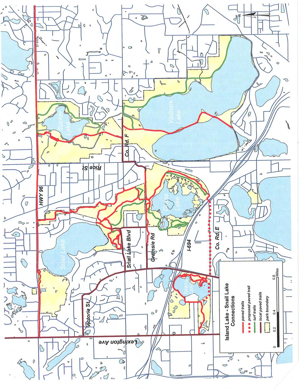
11 ATTACHMENT D 2030 Regional Parks Policy Plan Update Proposed System Changes Map Designation: P-4 Name: Vadnais-Snail Lakes Regional Park Agency: Ramsey County Category: Proposed Regional Park Boundary Adjustment Acres: 93 Acquisition Costs: $0 Request Ramsey County has requested that the Metropolitan Parks and Open Space Commission and the Metropolitan Council consider expanding the boundary of Vadnais-Snail Lakes Regional Park to include Island Lake County Park as part of the Parks Policy Plan update. Background Vadnais-Snail Lakes Regional Park is located north of I-694 between I-35W and I-35E in Vadnais Heights and Shoreview. The park is comprised of five segments, including: Sucker Lake (273 acres), Vadnais Lake (303 acres), Grass Lake (271 acres), Snail Lake and Snail Lake Corridor (30 and 142 acres), for a total size of 1,019 acres. These segments of the regional park are interconnected by a network of park trails. Island Lake County Park is located approximately one-third of a mile west of Snail and Grass Lakes and is bounded by I-694 to the north, Victoria Street to the east, the Canadian Pacific-Soo Line Railroad to the south and Lexington Avenue and private property to the west. Although it is located south of I-694, local paved trails along Victoria Street, Gramsie Road and Snail Lake Road (County Road F) provide access to Vadnais-Snail Lakes Regional Park Additionally, paved trails located on the east side of Grass Lake provide a trail bridge over I-694 to County Road E, which has paved shoulders providing a connection to Island Lake County Park. The City of Shoreview s Comprehensive Plan identifies a proposed local trail along County Road E. Sufficient right-of-way exists the entire distance between the I-694 bridge and Victoria Street to develop a separate trailway, although there are no immediate plans for development of the trail. 41
12 ATTACHMENT D Island County Park consists of 93 acres surrounding the majority of Island Lake and includes three picnic shelters (two that seat 100 people each and one that seats 50 people), a large play area and two sand volleyball courts on the east side of the lake; a boat launch and fishing pier as well as a 9-hole golf course on the northwest side of the lake; and a natural area on the southwest side of the lake. The park also includes one mile of bituminous trails. For over 25 years, the park has hosted a series of regional waterski events sponsored by the Minnesota Waterski Association. Ramsey County has not conducted formal use counts or visitor origin studies; however, in 2009, 188 special use permits were issued for the park involving over 21,000 park visitors. Based on these permits, over 44 percent were non-local visits. The Minnesota Department of Transportation (Mn/DOT) has planned improvements for Interstate 694 between I-35W and I-35E. According to the 2006 Environmental Assessment that was prepared, the road project will impact Island County Park, although no direct acquisition of land from the park would be necessary. An existing park road is partially located on Mn/DOT right-of-way. This road would be removed and replaced with a 12-foot wide trail. Removal of the park road will discontinue access to the public boat launch, parking lot and fishing pier located on the northwest side of the lake. To mitigate the impacts to the boat launch and parking lot, Mn/DOT will relocate these facilities to the northeast portion of the park The fishing pier will be relocated to the east side of Island Lake. The I-694 project has not been scheduled for construction yet. Criteria The criteria for regional parks that are outlined in the 2030 Regional Parks Policy Plan are shown below in bold text. Since Vadnais-Snail Lakes Regional Park is already recognized as a regional park, the criteria is being applied to the proposed expansion area Island Lake County Park. Staff analysis is italicized. A regional park should: Be acres in size (with 100 acres as a minimum). Vadnais-Snail Lakes Regional Park consists of 1,019 acres. The proposed boundary expansion to include the 96-acre Island Lake County Park would bring the park to 1,112 acres, which is well above the minimum acreage required for a regional park. Serve a service area of 3-5 communities. Island Lake Regional Park is located in Shoreview, with the following communities located within 1.5 mile radius: Arden Hills, Roseville, Little Canada, and Vadnais Heights. The close proximity to these communities as well as the convenient access to the park provided by I-694 and Victoria Street ensure that the park serves at least 3-5 communities. The primary service area for the existing Vadnais-Snail Lakes Regional Park includes these communities and also stretches into North Oaks and New Brighton. Be in a natural setting contiguous to water bodies or watercourses if possible. 42
13 ATTACHMENT D Island Lake County Park surrounds the majority of Island Lake; there are eight private residences with shoreline along the west side of the lake. The southwest portion of the park includes a series of wetlands and is maintained in a natural state. The existing Vadnais-Snail Lakes Regional Park is also contiguous to several water bodies. Much of the park contains Regionally Significant Natural Resource and Ecological Areas as mapped by the Metropolitan Council and the Minnesota Department of Natural Resources. Provide nature oriented recreation such as picnicking, boating, fishing, swimming, camping and trail uses. Activities provided at Island Lake County Park include picnicking, boating, fishing, swimming and trail uses, which are consistent with typical recreation at regional parks. 43
14 44 ATTACHMENT D
15 45 ATTACHMENT D
16 ATTACHMENT D 46

17 47 ATTACHMENT D
18 48 ATTACHMENT D
19 ATTACHMENT D 2030 Regional Parks Policy Plan Update Proposed System Changes Map Designation: T-14 Name: Rice Creek South Regional Trail Agency: Ramsey County Category: Regional Trail Search Corridor Miles: 2 Acquisition Costs: TBD Request Ramsey County has requested that the Metropolitan Parks and Open Space Commission (MPOSC) and the Metropolitan Council consider the designation of a regional trail search corridor through the Twin Cities Army Ammunition Plant (TCAAP) site as part of the Parks Policy Plan update. Background The former TCAAP site is located in Arden Hills and is bounded by County Road I to the north, Lexington Avenue to the east, Highway 96 to the south and Highway 10-Interstate 35W to the west. TCAAP was built in 1941 and made over 16.5 billion rounds of small arms ammunitions through World War II, the Korean War and the Vietnam conflict. It was decommissioned in the late 1970s and was declared a Superfund site in The site consists of approximately 2,370 acres. The eastern two-thirds of the site is the home of the Arden Hills Army Training Site (AHATS), which is under the control of the Minnesota National Guard through a long-term lease agreement with the Army. In 1994, Congressman Bruce Vento formed a committee to develop a reuse plan for the entire site. Recommended land uses include open space, preservation of natural features, transit, housing, retail and employment. The conceptual Vento Plan called for the AHATS portion of the site to become a park preserve. In 2006, the National Park Service transferred 113 acres of land along Rice Creek in the northwest portion of the TCAAP site to Ramsey County as part of the Federal Lands to Parks Program. A key segment of the Rice Creek North Regional Trail was developed on this property and opened to the public in A 49-acre wildlife corridor was included in the master plan for the Rice Creek North Regional Trail, but this land is still part of the TCAAP property. 49
20 ATTACHMENT D The City of Arden Hills had submitted an offer to purchase the western 585 acres of the TCAAP site (including the 49-acre wildlife corridor) from the Army in 2006 and had been working with a development partner to plan for the purchase and redevelopment of the property. In 2009, the developer withdrew from the project. The Army, through the General Services Administration, is preparing to sell through a public auction in the summer Ramsey County is proposing the Rice Creek South Regional Trail to be located on the eastern portion of the 585 acre site, which would connect the Rice Creek North Regional Trail to the Highway 96 Regional Trail. Conceptually, the trail corridor would be approximately 150 feet wide, would be located adjacent to the wildlife area to the south, and would include approximately 30 acres. Ramsey County is also proposing a 500 foot wide strip of land that would extend south from County Road I across the AHATS and TCAAP area to the north portion of the wildlife corridor. This land would serve as a trailhead and staging area for recreational access to the AHATS area for winter recreational activities, as well as provide access to the Rice Creek North Regional Trail and the wildlife corridor. The Arden Hills City Council unanimously passed a resolution supporting transferring land from the TCAAP property to Ramsey County for the Rice Creek South Regional Trail Corridor, the AHATS trailhead and the Vento Wildlife Corridor (Resolution No ) on December 21, The Ramsey County Board of Commissioners unanimously passed Resolution on January 19, 2010 which: Approved the additions of the 30 acre trail corridor, the 49 acre wildlife corridor and the 29 acre trailhead access to the Rice Creek Regional Trail; Authorized staff to prepare an amendment to the Rice Creek Regional Trail Master Plan that incorporates these additional properties; Authorized staff to seek transfer of these properties from the GSA to Ramsey County either directly or through a Federal agency sponsor; and Authorized staff to seek Congressional action, if necessary, to facilitate the environmental remediation and transfer of these properties to Ramsey County for regional trail purposes. Criteria The 2030 Regional Parks Policy Plan outlines the following criteria for regional trails. Staff analysis is italicized. Strategy 1(c): Siting criteria and land acquisition funding priorities for regional trails To qualify for regional trail status, an existing or proposed trail must meet the following criteria: 50
21 ATTACHMENT D 1. The trail should not duplicate an existing trail. The trail may include a portion of an existing county or local trail if the trail serves one of the following functions: (A) Destination Regional Trail. Be a destination itself, providing a highquality recreation experience that traverses significant natural resource areas where the trail treadway will have no adverse impact on the natural resource base; (B) Linking Regional Trail. Link two or more units of the regional recreation open space system. The proposed Rice Creek South Regional Trail does not duplicate an existing trail and will serve as a regional linking trail. The trail will connect the Rice Creek North Regional Trail, a destination trail, and the Highway 96 Regional Trail, a linking trail. 2. The trail must serve a regional audience based on visitor origin and service-area research on regional trails. The Rice Creek North Regional Trail is jointly managed by Ramsey and Anoka Counties and will connect Long Lake Regional Park in New Brighton to the Rice Creek Chain of Lakes Park Reserve in Lino Lakes. The Highway 96 Regional Trail is complete from Arden Hills to White Bear Lake, where it will connect to planned portions of the Bruce Vento Regional Trail. The trail will also eventually connect to Long Lake Regional Park. These trail connections will ensure that the trail will serve a regional audience. New Linking Regional Trails should be located within the developing or developed area of the region. For Linking Regional Trails, any two trails running parallel to each other and not separated by natural or human-built barriers should be at least 1.5 miles apart so as not to overlap the localized service area of those trails. Whenever possible, Linking Regional Trails should be located to reasonably maximize inclusion of high quality natural resources and connections to local trails, areas of lifecycle and affordable housing, and areas of infill and redevelopment. The 2030 Regional Development Framework classifies Arden Hills as a developed community, although the TCAAP property presents development opportunities. The proposed Lexington Avenue Regional Trail is a linking trail that parallels the proposed Rice Creek South Regional Trail. Although these trails will be approximately 1.25 to 1.5 miles apart, the Rice Creek South Regional Trail will provide a staging area and access to recreational opportunities at the AHATS site, which cannot be provided with the Lexington Avenue Regional Trail. The Rice Creek South Regional Trail will also provide access to natural resources along Rice Creek and the wildlife corridor, and to areas of potential development of housing, employment and retail in the remainder of the TCAAP site. 51
22 52 ATTACHMENT D
23 ATTACHMENT D 2030 Regional Parks Policy Plan Update Proposed System Changes Map Designation: T-15 Name: Trout Brook Regional Trail Agency: Ramsey County Category: Regional Trail Extension Miles: 3.5 Acquisition Costs: TBD Request Ramsey County has requested that the Metropolitan Parks and Open Space Commission (MPOSC) and the Metropolitan Council consider an extension of the Trout Brook Regional Trail from its terminus in Roseville to Vadnais-Snail Lakes Regional Park in Vadnais Heights as part of the Parks Policy Plan update. Background The 2030 Regional Parks Policy Plan gave recognition of regional status to the Trout Brook Trail and authorized its extension through St. Paul. The existing portion of the trail is managed by Ramsey County and begins at Lake McCarrons County Park in Roseville and ends at the Gateway State Trail in St. Paul. St. Paul prepared a master plan amendment for the trail, which incorporates the Trillium Nature Sanctuary and extends the trail south through St. Paul to connect to the Sam Morgan Regional Trail. This segment of the trail will be managed by St. Paul. MPOSC reviewed the master plan amendment at its February 2, 2010 meeting and the Metropolitan Council approved it on February 24, Ramsey County is proposing to extend the regional trail north from its terminus in Roseville through Little Canada to connect to Vadnais-Snail Lakes Regional Park in Vadnais Heights. The National Park Service, through its Rivers, Trails and Conservation Assistance Program (RTCA), is partnering with the City of Little Canada to conduct a feasibility study to plan for trail alignment alternatives. The trail would require bridge crossings at Highway 36 and Interstate 694. Criteria The 2030 Regional Parks Policy Plan outlines the following criteria for regional trails. Staff analysis is italicized. Strategy 1(c): Siting criteria and land acquisition funding priorities for regional trails 53
24 ATTACHMENT D To qualify for regional trail status, an existing or proposed trail must meet the following criteria: 1. The trail should not duplicate an existing trail. The trail may include a portion of an existing county or local trail if the trail serves one of the following functions: (A) Destination Regional Trail. Be a destination itself, providing a highquality recreation experience that traverses significant natural resource areas where the trail treadway will have no adverse impact on the natural resource base; (B) Linking Regional Trail. Link two or more units of the regional recreation open space system. The proposed extension of the Trout Brook Regional Trail does not duplicate an existing trail and will serve as a regional linking trail. The trail will connect the Sam Morgan Regional Trail, the Gateway State Trail, Lake McCarrons County Park and Vadnais Snail Lakes Regional Park. 2. The trail must serve a regional audience based on visitor origin and service-area research on regional trails. The trail will travel through St. Paul, Roseville, Little Canada and Vadnais Heights. With a connection to the Gateway State Trail, which leads from St. Paul to Pine Point Regional Park in Washington County, this trail will serve a regional audience. New Linking Regional Trails should be located within the developing or developed area of the region. For Linking Regional Trails, any two trails running parallel to each other and not separated by natural or human-built barriers should be at least 1.5 miles apart so as not to overlap the localized service area of those trails. Whenever possible, Linking Regional Trails should be located to reasonably maximize inclusion of high quality natural resources and connections to local trails, areas of lifecycle and affordable housing, and areas of infill and redevelopment. The 2030 Regional Development Framework classifies St. Paul, Roseville, Little Canada and Vadnais Heights as developed communities. There are two regional trails that parallel the proposed extension of the Trout Brook Regional Trail the proposed Lexington Avenue Regional Trail and the Bruce Vento Regional Trail, which are more than two and three miles away, respectively. The City of Little Canada has existing and planned local trails that may provide connection opportunities to the regional trail. The City s comprehensive plan discusses the potential for townhouse or senior housing development in the north portion of the city near Lake Vadnais, in the general area of the proposed trail. 54
Metro Transit Service Improvement Plan
 Metro ransit Service Improvement Plan ransportation Committee April 13, 2015 Cyndi Harper Manager of Route Planning Kyle Burrows ransit Planner What is the Service Improvement Plan (SIP)? Bus service expansion
Service Improvement Plan
 Metro ransit Service Improvement Plan ransportation Committee April 13, 2015 Cyndi Harper Manager of Route Planning Kyle Burrows ransit Planner What is the Service Improvement Plan (SIP)? Bus service expansion
Metropolitan Council 2016 Population and Household Estimates Published July 2017
 Metropolitan Council 2016 and s Published July 2017 City or Township Andover 30,598 32,335 1,737 9,811 10,391 580 Anoka 17,142 17,995 853 7,060 7,436 376 Bethel 466 461-5 174 174 0 Blaine (part) 57,186
Metropolitan Council 2017 Final Population and Household Estimates Certified and published July 2018
 Metropolitan Council Final and s Certified and published July 2018 City or Township - - Andover 30,598 32,470 1,872 9,811 10,445 634 Anoka 17,142 18,205 1,063 7,060 7,525 465 Bethel 466 499 33 174 179
Twin Cities Region Population and Household Estimates, 2014 (PRELIMINARY)
") and Household s, (PRELIMINARY) Andover 30,598 31,874 1,276 9,811 10,273 462 Anoka 17,142 17,586 444 7,060 7,252 192 Bethel 466 477 11 174 177 3 Blaine (part) 57,186 62,066 4,880 21,077 22,647 1,570 Centerville
and Household s, (PRELIMINARY) Andover 30,598 31,874 1,276 9,811 10,273 462 Anoka 17,142 17,586 444 7,060 7,252 192 Bethel 466 477 11 174 177 3 Blaine (part) 57,186 62,066 4,880 21,077 22,647 1,570 Centerville
This document is made available electronically by the Minnesota Legislative Reference Library as part of an ongoing digital archiving project.
 This document is made available electronically by the Minnesota Legislative Reference Library as part of an ongoing digital archiving project. http://www.leg.state.mn.us/lrl/lrl.asp 13-0194 Metropolitan
Metropolitan Parks and Open Space Commission Subject District(s), Member(s): Policy/Legal Reference: Staff Prepared/Presented: Division/Department:
, Member(s): Policy/Legal Reference: Staff Prepared/Presented: Division/Department:") Business Item Metropolitan Parks and Open Space Commission Meeting date: May 20, 2013 Subject: Proposed System Addition Discussion for the 2040 Regional Parks Policy Plan District(s), Member(s): All Policy/Legal
Business Item Metropolitan Parks and Open Space Commission Meeting date: May 20, 2013 Subject: Proposed System Addition Discussion for the 2040 Regional Parks Policy Plan District(s), Member(s): All Policy/Legal
PARTICIPATION IN THE LIVABLE COMMUNITIES ACT LOCAL HOUSING INCENTIVE ACCOUNT A
 This document is made available electronically by the Minnesota Legislative Reference Library as part of an ongoing digital archiving project. http://www.leg.state.mn.us/lrl/lrl.asp PARTICIPATION IN THE
Baker/Carver Regional Trail master plan public review draft
 Baker/Carver Regional Trail master plan public review draft November 2014 the mission of Three Rivers Park District is to promote environmental stewardship through recreation and education in a natural
Table 14 Ranking of Per Capita Outstanding Long-Term Debt Cities Over 2,500 in Population For the Year Ended December 31, 1999
 WACONIA 5,818 $40,482,394 $6,958 BLUE EARTH 3,642 20,397,618 5,601 GLENCOE 5,368 27,884,598 5,195 BUFFALO 9,950 50,868,148 5,112 CHASKA 15,801 76,712,330 4,855 MARSHALL 12,825 61,989,898 4,834 PARK RAPIDS
Anoka County Foreclosures (2006)
") noka County Foreclosures (26) Elk River 48 urns ) 47 St. Francis 17 Oak ethel East ethel Linwood 48 Ramsey ndover 49 Ham Columbus 35 ) 97 1 noka Champlin 169 49 47 47 Coon Rapids ) 242 laine 51 Centerville
noka County Foreclosures (26) Elk River 48 urns ) 47 St. Francis 17 Oak ethel East ethel Linwood 48 Ramsey ndover 49 Ham Columbus 35 ) 97 1 noka Champlin 169 49 47 47 Coon Rapids ) 242 laine 51 Centerville
Ranking of 1998 Per Capita Expenditures Cities Over 2,500 in Population
 Ranking of 1998 Per Capita Expenditures July 24, 2000 Government Information Division Office of the State Auditor State of Minnesota 525 Park Street, Suite 400, St. Paul, MN 55103 gid@osa.state.mn.us www.osa.state.mn.us
Webinar Series for Comprehensive Plan Updates. Making Your Plan a Walk in the Park
 Webinar Series for Comprehensive Plan Updates Making Your Plan a Walk in the Park Presented by Jan Youngquist and Michael Peterka September 15, 2016 Today s Presentation Importance of Parks and Trails
2006 Nonresidential Construction in the Twin Cities Region
 Publication No.74-07-047 October 2007 2006 Nonresidential Construction in the Twin Cities Region Introduction This report provides a regionwide review of nonresidential construction activity. The report
2009 Regional Solicitation Selected Projects*
 2009 Regional Solicitation Selected Projects* Special Federal Allocation from the MPO Mn/DOT I-494/TH169 Interchange Reconstruction $34,000,000 Surface Transportation Program - Urban Guarantee AR-09-10
SNAPSHOT Investing in Roads and Bridges 2016 Budget for a Better Minnesota
 SNAPSHOT Investing in Roads and Bridges 2016 Budget for a Better Minnesota Modern roads, bridges, and transit are the foundation of an economy that works for all Minnesotans everywhere in Minnesota. Our
Business Item No XXX. Proposed Action That the Metropolitan Council approve the Coon Creek Regional Trail Master Plan.
 Business Item No. 2015-XXX Metropolitan Parks and Open Space Commission Meeting date: July 7, 2015 For the Community Development Committee meeting of July 20, 2015 For the Metropolitan Council meeting
Foreclosures and short sales
 Foreclosures and short sales in the Twin Cities Housing Market Update A Special Research Report from the Minneapolis Area Association of REALTORS Jeff Allen MAAR Research Manager www.mplsrealtor.com Aaron
Committee Report. Community Development Committee For the Metropolitan Council meeting of August 12, Business Item No.
 Committee Report Business Item No. 2015-168 Community Development Committee For the Metropolitan Council meeting of August 12, 2015 Subject: Coon Creek Regional Trail Master Plan, Anoka County Proposed
RANKING OF 2001 PER CAPITA EXPENDITURES OF CITIES OVER 2,500 IN POPULATION YEAR ENDED DECEMBER 31,2001
 RANKING OF 2001 PER CAPITA EXPENDITURES OF CITIES OVER 2,500 IN POPULATION YEAR ENDED DECEMBER 31,2001 Description of the Office of the State Auditor The Office of the State Auditor (OSA) serves as a watchdog
±22.22 acres of mixed-use land for sale
 Howard Clear Forest Sr. H.S. Hwy 97 (Scandia Trail-17,400 VPD) 66,000 VPD Running Aces Harness Park Forest Motor Sports Forest Sports Complex Forest Airport Forest Blvd N (8,700 VPD) Hwy 50 Future International
Section II. Planning & Public Process Planning for the Baker/Carver Regional Trail began in 2010 as a City of Minnetrista initiative.
 Section II Planning & Public Process Planning for the began in 2010 as a City of initiative. city staff began discussions with the Park District on the possibility of a north/south regional trail connection
Minnesota Department of Transportation 2011 Twin Cities Metro Area Construction Projects
 Minnesota Department of Transportation 2011 Twin Cities Metro Area Construction Projects 1 N 14 9 Chisago Interstate Highway 2011 Project Sites 8 12 6 Anoka 1 6 0 6 22 6 6 9 12 7 7 7 284 74 2 41 71 29
2. Goals and Policies. The following are the adopted Parks and Trails Goals for Stillwater Township:
 D. PARKS AND TRAILS 1. Introduction Stillwater Township s population is relatively low, with most residents living on rural residences on large lots. The need for active park space has been minimal in
Design Charrette Public Meeting
 Design Charrette Public Meeting Citizen Advisory Committee Members of the Public November 2, 2011 - Theodore Wirth Chalet - 6:30-8:30 p.m. Park Background: Visitation Estimation 2010 Regional Visitation
REQUEST FOR COUNCIL ACTION
 REQUEST FOR COUNCIL ACTION Date: 10-24-2016 Item No.: 14.e Department Approval City Manager Approval Item Description: Roseville Deer Management 1 2 3 4 5 6 7 BACKGROUND The City of Roseville, in conjunction
METROPOLITAN COUNCIL 390 North Robert Street, St. Paul, MN Phone (651) TDD (651)
 TDD (651)") DATE: March 27, 2012 METROPOLITAN COUNCIL 390 North Robert Street, St. Paul, MN 55101 Phone (651) 602-1000 TDD (651) 291-0904 TO: Metropolitan Parks and Open Space Commission FROM: Arne Stefferud, Planning
DATE: March 27, 2012 METROPOLITAN COUNCIL 390 North Robert Street, St. Paul, MN 55101 Phone (651) 602-1000 TDD (651) 291-0904 TO: Metropolitan Parks and Open Space Commission FROM: Arne Stefferud, Planning
Business Item No xx
 Business Item No. 2015-xx Metropolitan Parks and Open Space Commission Meeting date: April 7, 2015 For the Community Development Committee meeting of April 21, 2015 For the Metropolitan Council meeting
2013 HOUSING COUNTS November 2014
 2013 HOUSING COUNTS November 2014 MINNEAPOLIS 2013 Affordable Units with Financing Closed New Production: Rental @30% @50% @60% AMI AMI AMI Pillsbury Historic Redevelopment... 251 *Snelling Apartments
CHAPTER 1 TRANSIT MARKET AREAS AND EXISTING SERVICE
 CHAPTER 1 TRANSIT MARKET AREAS AND EXISTING SERVICE Transit Market Areas While several factors influence the propensity to use transit, the primary predictors of transit productivity are the density of
ANNUAL USE ESTIMATE OF THE REGIONAL PARKS SYSTEM FOR 2016 BASED ON A FOUR-YEAR AVERAGE OF VISIT DATA FROM 2013 THROUGH 2016
 ANNUAL USE ESTIMATE OF THE REGIONAL PARKS SYSTEM FOR 2016 BASED ON A FOUR-YEAR AVERAGE OF VISIT DATA FROM 2013 THROUGH 2016 The Council s mission is to foster efficient and economic growth for a prosperous
RETAIL / RESTAURANT EXPERIENCE
 PROJECT/LOCATION SIZE/SQUARE FOOT BUILDING TYPE 7th Place Building St. Paul, MN 20,000 Retail 7th Place Building - Phase 2B St. Paul, MN 10,000 Retail 1221 West Lake St. Minneapolis, MN 39,000 Office/Retail
Postal Verification Card Report for November 2010 General Election
 This document is made available electronically by the Minnesota Legislative Reference Library as part of an ongoing digital archiving project. http://www.leg.state.mn.us/lrl/lrl.asp STATE OF MINNESOTA
Business Item No
 Metropolitan Parks and Open Space Commission Meeting date: February 6, 2018 For the Community Development Committee meeting of February 20, 2018 For the Metropolitan Council meeting of February 28, 2018
DEMOGRAPHICS AND EXISTING SERVICE
 EXECUTIVE SUMMARY The Central Corridor light-rail transit (LRT) project will open in 2014 and operate between downtown Minneapolis and downtown St. Paul, serving the University of Minnesota and University
STATE OF MINNESOTA DEPARTMENT OF NATURAL RESOURCES
 STATE OF MINNESOTA DEPARTMENT OF NATURAL RESOURCES Pursuant to Minnesota Statutes, Section 105.391, Subd.1, the Commissioner of Natural Resources hereby publishes the final inventory of Protected (i.e.
Segment 2: La Crescent to Miller s Corner
 goal of the USFWS refuges is to conserve, protect and enhance fish, wildlife and plants and their habitats for the continuing benefit of the American people. Refuge lands are used largely for fishing,
CITY OF CHASKA PEDESTRIAN MOVEMENT / TRAILS PLAN FINAL CHAPTER 7 PEDESTRIAN MOVEMENT / TRAILS PLAN. Page 1 of 19, Chapter 7
 FINAL CHAPTER 7 PEDESTRIAN MOVEMENT / TRAILS PLAN Page 1 of 19, Chapter 7 ORDER OF CONTENTS I. INTRODUCTION... 3 II. PURPOSE... 3 III. 2030 COMMUNITY TRAILS SYSTEM PLAN... 4 IV. TRAIL TYPES... 7 A. Regional
Southwest LRT Alignment Video Narration
 Southwest LRT Alignment Video Narration September 2015 Southwest Light Rail Transit, a proposed extension of the METRO Green Line, will serve Minneapolis, St. Louis Park, Hopkins, Minnetonka and Eden Prairie.
Community Development Committee
 C Community Development Committee For the Metropolitan Council meeting of October 31, 2012 Committee Report Item:2012-316 ADVISORY INFORMATION October 16, 2012 Date Prepared: Subject: Intercity Regional
Section 4(f)/6(f) Determination Technical Report for Park and Recreational Lands
/6(f) Determination Technical Report for Park and Recreational Lands") Section 4(f)/6(f) Determination Technical Report for Park and Recreational Lands 1.0 Introduction 1.1 Purpose of Report This Section 4(f)/6(f) Determination Technical Report for Park and Recreational Lands
Section 4(f)/6(f) Determination Technical Report for Park and Recreational Lands 1.0 Introduction 1.1 Purpose of Report This Section 4(f)/6(f) Determination Technical Report for Park and Recreational Lands
ANNUAL USE ESTIMATE OF THE METROPOLITAN REGIONAL PARKS SYSTEM FOR 2013 BASED ON A FOUR-YEAR AVERAGE OF VISIT DATA FROM 2010 THROUUGH 2013
 ANNUAL USE ESTIMATE OF THE METROPOLITAN REGIONAL PARKS SYSTEM FOR 2013 BASED ON A FOUR-YEAR AVERAGE OF VISIT DATA FROM 2010 THROUUGH 2013 July 2014 The Council s mission is to foster efficient and economic
regional park master plan
 master plan (50 min) master plan process review Needs Assessment Community Input: 2 previous CAC meetings Community Open House - June 12 On-line input through June 19 purpose for tonight Review the Needs
LINK (5465) N. Robert St., St. Paul, MN 55101
 N. Robert St., St. Paul, MN 55101") 651-602-LINK (5465) www.transitlinktc.org 390 N. Robert St., St. Paul, MN 55101 Service Details Customer Guide Table of Contents Customer Guide... page 1 Service Details... page 2 Areas... page 2 Eligibility...
651-602-LINK (5465) www.transitlinktc.org 390 N. Robert St., St. Paul, MN 55101 Service Details Customer Guide Table of Contents Customer Guide... page 1 Service Details... page 2 Areas... page 2 Eligibility...
*Note: This data is preliminary and subject to change*
 *Note: This data is preliminary and subject to change* This product is an objective analysis of NWS Cooperative Observer Program (COOP) and Community Collaborative Rain, Hail and Snow Network (CoCoRaHS)
MEETING OF THE METROPOLITAN PARKS AND OPEN SPACE COMMISSION Tuesday, April 4, 2017
 Minutes of the MEETING OF THE METROPOLITAN PARKS AND OPEN SPACE COMMISSION Tuesday, April 4, 2017 Committee Members Present: Tony Yarusso, Rick Theisen, Robert Moeller, Todd Kemery, Sarah Hietpas, Margie
Committee Report. Community Development Committee For the Metropolitan Council meeting of April 13, Business Item No.
 Committee Report Business Item No. 2016-48 Community Development Committee For the Metropolitan Council meeting of April 13, 2016 Subject: Harriet Island-South St. Paul Regional Trail Master Plan, Saint
SOUTHEAST CORNER OF HIGHWAY 36 & FAIRVIEW AVENUE NORTH ROSEVILLE (MINNEAPOLIS MSA), MN
, MN") SOUTHEAST CORNER OF HIGHWAY 36 & FAIRVIEW AVENUE NORTH ROSEVILLE (MINNEAPOLIS MSA), MN INVESTMENT HIGHLIGHTS S U B J E C T O F F E R I N G Mid-America Real Estate Corporation, in cooperation with Mid-America
SOUTHEAST CORNER OF HIGHWAY 36 & FAIRVIEW AVENUE NORTH ROSEVILLE (MINNEAPOLIS MSA), MN INVESTMENT HIGHLIGHTS S U B J E C T O F F E R I N G Mid-America Real Estate Corporation, in cooperation with Mid-America
July 2016 ANNUAL USE ESTIMATE OF THE REGIONAL PARKS SYSTEM FOR 2015 BASED ON A FOUR-YEAR AVERAGE OF VISIT DATA FROM 2012 THROUGH 2015
 July 2016 ANNUAL USE ESTIMATE OF THE REGIONAL PARKS SYSTEM FOR 2015 BASED ON A FOUR-YEAR AVERAGE OF VISIT DATA FROM 2012 THROUGH 2015 The Council s mission is to foster efficient and economic growth for
DOWNTOWN EAST RESTAURANT AND RETAIL SPACE. Matt Friday. Senior Vice President
 DOWNTOWN EAST RESTAURANT AND RETAIL SPACE AVAILABLE for lease Matt Friday Senior Vice President 612 336 4209 matt.friday@cbre.com David Daly Vice President 612 336 4319 david.daly@cbre.com Eric Sheaffer
A CASE FOR COMPLETING THE JORDAN RIVER PARKWAY: A
 A CASE FOR COMPLETING THE JORDAN RIVER PARKWAY: A safe crossing at 9000 South and 850 West Proposed 9000 South Underpass Parkway Timeline Parkway, Trail, and Tourism Facts Blueprint Jordan River 1971 1973
Corridor Management Committee Meeting. April 2, 2014
 Corridor Management Committee Meeting April 2, 2014 1 Today s Topics Welcome Approval of Minutes Resolutions Response to March 26 CMC Questions Staff Recommendation on Project Scope and Budget Public Testimony
HealthPartners Journey Pace (PPO) HealthPartners Journey Steady (PPO) HealthPartners Journey Stride (PPO) HealthPartners Journey Group (PPO)
 HealthPartners Journey Steady (PPO) HealthPartners Journey Stride (PPO) HealthPartners Journey Group (PPO)") HealthPartners Journey Pace (PPO) HealthPartners Journey Steady (PPO) HealthPartners Journey Stride (PPO) HealthPartners Journey Group (PPO) 2019 PHARMACY DIRECTORY This Pharmacy Directory was updated
HealthPartners Journey Pace (PPO) HealthPartners Journey Steady (PPO) HealthPartners Journey Stride (PPO) HealthPartners Journey Group (PPO) 2019 PHARMACY DIRECTORY This Pharmacy Directory was updated
Annual Use Estimate of the Metropolitan Regional Park System for 1999
 This document is made available electronically by the Minnesota Legislative Reference Library as part of an ongoing digital archiving project. http://www.leg.state.mn.us/lrl/lrl.asp ) ~. I Annual Use Estimate
Freeway Volume-Crash Summary
 Freeway Volume-Crash Summary Twin Cities Metropolitan Area Continuation Report 22 Data Minnesota Department of Transportation Office of Traffic, Security and Operations Freeway Operations Section Regional
METROPOLITAN COUNCIL 390 North Robert Street, St. Paul, MN Phone (651) TDD (651)
 TDD (651)") METROPOLITAN COUNCIL 390 North Robert Street, St. Paul, MN 55101 Phone (651) 602 1000 TDD (651) 291 0904 DATE: June 19, 2007 TO: Metropolitan Parks and Open Space Commission FROM: Jan Youngquist, Senior
METROPOLITAN COUNCIL 390 North Robert Street, St. Paul, MN 55101 Phone (651) 602 1000 TDD (651) 291 0904 DATE: June 19, 2007 TO: Metropolitan Parks and Open Space Commission FROM: Jan Youngquist, Senior
Active Living Partners. Trails. Hennepin County. Bloomington. Brooklyn Park. Crystal. Excelsior. Golden Valley. Hopkins. Independence.
 d rove app Active Living Partners When using the do. seal of approval in publications, include service mark notice: do. is a registered mark of Blue Cross and Blue Shield of Minnesota, a nonprofit independent
HealthPartners Journey Stride (PPO)
") HealthPartners Journey Stride (PPO) 2018 PHARMACY DIRECTORY This Pharmacy Directory was updated March 2018. For more recent information or other questions, please contact HealthPartners Member Services
HealthPartners Journey Stride (PPO) 2018 PHARMACY DIRECTORY This Pharmacy Directory was updated March 2018. For more recent information or other questions, please contact HealthPartners Member Services
THREE RIVERS PARK DISTRICT
 THREE RIVERS PARK DISTRICT INTERGOVERNMENTAL AND COMMUNITY ENGAGEMENT COMMITTEE MEETING Administrative Center - Board Room 3000 Xenium Lane North, Plymouth, MN 1. CALL TO ORDER Thursday, November 6, 2014
Extending TRACKS. Design and engineering effort nears completion. Animation shows how light rail will operate in Hopkins
 February 2017 Issue 16 www.swlrt.org Extending TRACKS Design and engineering effort nears completion The Southwest LRT Project has finalized its civil design and is finalizing systems and Operations and
Cascade River State Park Management Plan Amendment
 This document is made available electronically by the Minnesota Legislative Reference Library as part of an ongoing digital archiving project. http://www.leg.state.mn.us/lrl/lrl.asp Cascade River State
Sun Apr 5 Sat Apr 11, 2015 (Central Time)
") Sun Apr 5 Sat Apr 11, 2015 (Central Time) 4am Sun 4/5 Mon 4/6 Tue 4/7 Wed 4/8 Thu 4/9 Fri 4/10 Sat 4/11 5am Team Run--Lake Calhoun Executive Center/3033 Excelsior Blvd/Mpls, 55416-12pm 1pm 2pm 3pm Sun
Sun Apr 5 Sat Apr 11, 2015 (Central Time) 4am Sun 4/5 Mon 4/6 Tue 4/7 Wed 4/8 Thu 4/9 Fri 4/10 Sat 4/11 5am Team Run--Lake Calhoun Executive Center/3033 Excelsior Blvd/Mpls, 55416-12pm 1pm 2pm 3pm Sun
Greater Minnesota Regional Parks and Trails Commission Designation Application
 Greater Minnesota Regional Parks and Trails Commission Designation Application General Section Designation Application #: 15-059D Date Submitted: 06/16/2015 Park or Trail Name: Mesabi Trail District #:
Annual Use Estimate of the Metropolitan Regional Parks System for 2011 Based on a four year average of visitation data from 2008 through 2011
 Annual Use Estimate of the Metropolitan Regional Parks System for 2011 Based on a four year average of visitation data from 2008 through 2011 December 2012 (revised) 390 North Robert Street St. Paul, Minnesota
FREE Summer Events in Ramsey County to Keep Families Active Recurring events Page 2 (Camps, Nature, Sports, Arts, Music) One Time Events Page 3 Parks
 One Time Events Page 3 Parks") FREE Summer Events in Ramsey County to Keep Families Active Recurring events Page 2 (Camps, Nature, Sports, Arts, Music) One Time Events Page 3 Parks and Pools Page 4 Museums and Zoos Page 4 Movies, Music,
FREE Summer Events in Ramsey County to Keep Families Active Recurring events Page 2 (Camps, Nature, Sports, Arts, Music) One Time Events Page 3 Parks and Pools Page 4 Museums and Zoos Page 4 Movies, Music,
BRACEVILLE NATURE PRESERVE Introductions History Present Conditions Future Development Plans Implementation Strategies Statistics
 BRACEVILLE NATURE PRESERVE Introductions History Present Conditions Future Development Plans Implementation Strategies Statistics Introduction Braceville Nature Preserve is one of MetroParks largest preserves.
National Transportation Safety Board Recommendation and FAA Air Traffic Orders
 Page 1 of 8 MEMORANDUM TO: Planning, Development and Environment Committee FROM: Chad E. Leqve, Director Environment (725.6326) SUBJECT: NOISE OVERSIGHT COMMITTEE (NOC) CONVERGING RUNWAY OPERATION (CRO)
2. 1:35 to 1:50 MSP Long-Term Comprehensive Plan Update. 3. 1:50 to 2:05 Update on Runway 17 RNAV Departure Procedure 24-Hour Trial
 Minneapolis/St. Paul International Airport (MSP) Noise Oversight Committee (NOC) Meeting Agenda May 20, 2009 1:30 P.M. Lindbergh Conference Room MAC General Office Building 6040 28 th Avenue South Minneapolis,
FINAL PAY 2012 TAX RATES
 FINAL PAY 2012 TAX RATES 4/3/2012 (1) (2) (3) (4) (5) SCH. DIST. CITY OR TOTAL LOCAL MARKET MUNICIPALITY & DIST & W/S CODE TOWN COUNTY SCHOOLS MISC TAX RATE TAX RATE ARDEN HILLS 621 (R) 2517 25.544% 61.316%
PURPOSE AND NEED. Introduction
 Public Scoping: Allocation of Recreation Capacity for Commercial Outfitter Guide Services on North Kruzof Island Trails (Kruzof Island Outfitter Guide) PURPOSE AND NEED Introduction The U.S. Department
Greater Minnesota Regional Parks and Trails Commission Designation Application
 Greater Minnesota Regional Parks and Trails Commission Designation Application General Section Designation Application #: 15-096D Date Submitted: 06/29/2015 Park or Trail Name: Barn Bluff Park District
Metropolitan Livable Communities Act Grants by City, 1996-Present
 Anoka Anoka Station Area Master Planning LCDA 2011 $22,500 $0 Anoka Greenhaven Housing LCDA 2010 $75,000 $0 Anoka IMI Cornelius (fka Eniva) TBRA 2007 $339,000 $101,162 Anoka Anoka North Central Business
Nine Mile Creek Regional Trail master plan
 Nine Mile Creek Regional Trail master plan December 19, 2013 the mission of Three Rivers Park District is to promote environmental stewardship through recreation and education in a natural resources-based
4.19 Parks, Recreation, and Conservation Lands
 interchange would have on the Reed Paige Clark Homestead located on the north side of Stonehenge Road. Alternative D would also affect Palmer Homestead, E.F. Adams House, and Knapp Brothers Shoe Manufacturing
Annual Use Estimate of the Metropolitan Regional Parks System for 2010 Based on a four year average of visitation data from 2007 through 2010
 This document is made available electronically by the Minnesota Legislative Reference Library as part of an ongoing digital archiving project. http://www.leg.state.mn.us/lrl/lrl.asp Annual Use Estimate
Number of Graduates Hired by Employer Class of St. Cloud State University, School of Education Campus
 ST CLOUD PS ST CLOUD MN 12 MINNEAPOLIS PS MINNEAPOLIS MN 7 ELK RIVER PS ELK RIVER MN 6 BUFFALO HANOVER MONTROSE PS BUFFALO MN 5 RUSH CITY PS RUSH CITY MN 5 MILACA PS MILACA MN 4 SAUK RAPIDS RICE PS SAUK
Hennepin County 2040 Bicycle Transportation Plan. Appendix D. Full list of planned bikeway system corridors
 Hennepin County 2040 Bicycle Transportation Plan Appendix D. Full list of planned bikeway system corridors Full Listing of Planned 2040 Bikeway System Segments Figure 1 Planned 2040 Bikeway System Corridors
2014 LEGISLATIVE AGENDA
 2014 LEGISLATIVE AGENDA BONDING SESSION Working to acquire, protect and enhance critical land for the public s use and benefit. 2014 LEGISLATIVE AGENDA In preparation for each session of the Minnesota
City of Haslett. City of East Lansing. City of East Lansing
 Central Park North (Nancy L. Moore Park) Lake Park North Expansion White Park Expansion #2 White Park Expansion #1 County East East Haslett East East TF87-212 Acquisition $90,000.00 Park. TF08-138 Acquisition
TWIN CITIES PREMIUM OUTLETS JOINT VENTURE WITH PARAGON OUTLETS
 EAGAN, MINNESOTA PROPERTY OVERVIEW TWIN CITIES PREMIUM OUTLETS JOINT VENTURE WITH PARAGON OUTLETS EAGAN, MN 52 35E MAJOR METROPOLITAN AREAS SELECT TENANTS 94 Minneapolis: St. Paul: RETAIL GLA (sq. ft.)
Proposal to Redevelop Lower Kananaskis River-Barrier Lake. Bow Valley Provincial Park. Frequently Asked Questions
 Proposal to Redevelop Lower Kananaskis River-Barrier Lake Bow Valley Provincial Park Frequently Asked Questions What is being proposed? What are the details of the proposal? Where is the project area located?
PROPOSED ALTERATION AND EXPANSION OF THE MOUNT PEARL MUNICIPAL BOUNDARY TO INCLUDE THE AREA OF THE FORMER PEARL ESTATE LANDS & ENVIRONS
 PROPOSED ALTERATION AND EXPANSION OF THE MOUNT PEARL MUNICIPAL BOUNDARY TO INCLUDE THE AREA OF THE FORMER PEARL ESTATE LANDS & ENVIRONS JANUARY 4, 2007 INTRODUCTION In accordance with Sections 3 to 6 inclusive
Chapter eight. Parks and Recreation. Introduction. Crystal Lake Park District
 Chapter eight Parks and Recreation Introduction One of the indicators of quality of life in a city is the parks and recreation system. The City of Crystal Lake is fortunate to have an excellent parks and
VOLUME II APPENDIX F DETAILED PHYSICAL DESCRIPTION OF PROJECT RESERVOIRS AND LANDS
 VOLUME II APPENDIX F DETAILED PHYSICAL DESCRIPTION OF PROJECT RESERVOIRS AND LANDS THE CENTRAL NEBRASKA PUBLIC POWER AND IRRIGATION DISTRICT FERC PROJECT NO. 1417 PHYSICAL DESCRIPTION OF PROJECT LANDS
THOMAS A. SWIFT METROPARK Introductions History Present Conditions Future Development Plans Implementation Strategies Statistics
 THOMAS A. SWIFT METROPARK Introductions History Present Conditions Future Development Plans Implementation Strategies Statistics Introduction As an open meadow park positioned along the Mahoning River,
TRUCKEE TAHOE AIRPORT DISTRICT BOARD OF DIRECTOR STAFF REPORT
 AGENDA ITEM: 11 TRUCKEE TAHOE AIRPORT DISTRICT BOARD OF DIRECTOR STAFF REPORT AGENDA TITLE: MEETING DATE: January 24, 2018 PREPARED BY: NTPUD Agency Partnership Opportunity, Multi-Use Trailhead Access
THREE RIVERS PARK DISTRICT
 THREE RIVERS PARK DISTRICT LONG-RANGE STRATEGIC INITIATIVES COMMITTEE MEETING Administrative Center - Board Room 3000 Xenium Lane North, Plymouth, MN Thursday, July 2, 2015 Estimated Time: 9:30 10:30 a.m.
M E M O R A N D U M TO: ISD #11 School Board Members FROM:
 05-22-17 T-1 M E M O R A N D U M TO: ISD #11 School Board Members FROM: Cindy Reichert, Anoka County Elections Manager DATE: MEETING DATE TBD SUBJECT: Resolution Establishing Combined Precincts 2017 Combined
The Chu property is a 6.57 acre parcel located in the Town of Superior on the west side of McCaslin Boulevard. In 2014, the Town of Superior acquired
 1 The Chu property is a 6.57 acre parcel located in the Town of Superior on the west side of McCaslin Boulevard. In 2014, the Town of Superior acquired the Chu property for open space with a contribution
Stephen Baker, SAMA, CAE County Assessor Tel: (651) Plato Blvd West, Suite 400 Fax: (651)
 Plato Blvd West, Suite 400 Fax: (651)") Stephen Baker, SAMA, CAE County Assessor Tel: (651) 266-2131 9 Plato Blvd West, Suite 4 Fax: (651) 266-21 Saint Paul, MN 5517 AskCountyAssessor@co.ramsey.mn.us March 25, 216 Dear Ramsey County Community,
Stephen Baker, SAMA, CAE County Assessor Tel: (651) 266-2131 9 Plato Blvd West, Suite 4 Fax: (651) 266-21 Saint Paul, MN 5517 AskCountyAssessor@co.ramsey.mn.us March 25, 216 Dear Ramsey County Community,
THE SETTING REGION COMMUNITY ANALYSIS
 THE SETTING REGION COMMUNITY ANALYSIS REGION Historical Setting The Crane Lake waterway pre-dates the American Indians who traveled its waters for generations before it became a fur-trading route for the
DRAFT 2040 CARVER COUNTY COMPREHENSIVE PLAN
 PARKS, OPEN SPACE, & TRAILS DRAFT 2040 CARVER COUNTY COMPREHENSIVE PLAN www.co.carver.mn.us/2040plan 6. Parks, Open Space, and Trails Plan Introduction The population in is expected to increase from the
NATIONAL PARK SERVICE CERTIFICATION OF COMPLETED SEGMENTS OF THE NORTH COUNTRY NATIONAL SCENIC TRAIL
 NATIONAL PARK SERVICE CERTIFICATION OF COMPLETED SEGMENTS OF THE NORTH COUNTRY NATIONAL SCENIC TRAIL Completed trail segments that (1) follow the route identified in the 1982 National Park Service (NPS)
University Region Non-Motorized Plan 2015
 Non-Motorized Transportation Non-motorized facilities are important components to the transportation system. They provide an environmentally-friendly, low-cost mode of travel. Some of the facilities can
2030 Comprehensive Plan A Policy Guide to 2030
 2030 Comprehensive Plan A Policy Guide to 2030 Parks and Open Spaces Approved by Board of Commissioners May 26, 2009 Adopted by Board of Commissioners September 7, 2010 Washington County Mission To provide
Mississippi River Parkway Commission of Minnesota
 Mississippi River Parkway Commission of Minnesota Metro Region (Elk River to Hastings) October 27, 2016 2:00 3:30 p.m. Historic Fort Snelling 200 Tower Avenue, St. Paul, MN Metro Region Agenda I. Welcome
Greater Minnesota Regional Parks and Trails Commission Designation Application
 Greater Minnesota Regional Parks and Trails Commission Designation Application General Section Designation Application #: 15-050D Date Submitted: 06/30/2015 Park or Trail Name: Perham to Pelican Rapids
Greater Minnesota Regional Parks and Trails Commission Designation Application
 Greater Minnesota Regional Parks and Trails Commission Designation Application General Section Designation Application #: 14-015D Date Submitted: 08/31/2015 Park or Trail Name: Alexander Ramsey Park District
Tinker Air Force Base, Oklahoma
 Table 5.4 Generalized Zoning within the Tinker AFB Clear Zones and Accident Potential Zones (Off-Installation) Category Acreage Residential 1,486 Commercial 191 Industrial 128 Public/Quasi-public 0 Recreational/Open/Agricultural/Low
5101 Shady Oak Road. Shady Oak Road. Lake Views
 Lake Views Shady Oak Road Welcome to Shady Oak Lake Corporate Center Striking views of Shady Oak Lake and strategically located in the Southwest suburban market, Shady Oak Lake Corporate Center is just