Marine Protected Areas of the United States. Conserving Our OCEANS. Updated January One Place at a Time
|
|
|
- Carmel Mason
- 5 years ago
- Views:
Transcription


1 Marine Protected Areas of the United States Conserving Our OCEANS One Place at a Time Updated January 2017 m a r i n e p r o t e c t e d a r e a s. n o a a. g o v
2 TABLE OF CONTENTS 4 Into the Deep: Exploring the Pacific Monuments 6 Bridging the Gulf: Connecting MPAs for a Healthier Gulf of Mexico 7 California s MPA Monitoring Program: How s the Network Doing? 8 Where are the Whales? Tracking Whales at Stellwagen Bank 10 Listening Posts: Documenting Noise in Marine Protected Areas 11 Growing Awareness and Salt Marshes in ACE Basin Marine Protected Areas: CONSERVING OUR OCEANS One Place at a time Marine protected areas (MPAs) are proven tools for conserving habitats, biodiversity and ecosystems. And effective protection has never been so greatly needed. Marine life is threatened by habitat loss, water quality, fishing impacts, climate change and other human impacts. In the U.S., MPAs have been part of the conservation landscape for decades, including marine and coastal national parks, national marine sanctuaries, national wildlife refuges, and similar areas managed by states and tribes. 12 Hawaii & Rapa Nui Exploring Cultural Connections Editor:... Lauren Wenzel Design:...Matt McIntosh Contributors:... Bill Kiene, Rachael Langston, Kalani Quiocho, Dave Wiley, NOAA Office of National Marine Sanctuaries; Joanne Flanders, NOAA Office of Exploration and Research; Stephanie Robinson, NOAA Office for Coastal Management; Cyndi Dawson, California Resources Agency; Cliff McCreedy, National Park Service. Cover Image:... Lauren Wenzel/NOAA PRINTED ON RECYCLED PAPER Well designed and managed MPA networks multiply conservation benefits by linking individual areas ecologically, connecting diverse habitats, and providing protection to species that use different habitats at different stages of their lives. Following California s example of an integrated MPA network of ecologically linked sites, many other MPA programs are increasingly recognizing the value of designed MPA networks, including reaching beyond our national borders to establish sister parks with international partners. This document summarizes information on MPAs in U.S. waters, focusing on sites established specifically to protect biodiversity, ecosystems and cultural heritage. Reflecting the IUCN definition of MPAs that is used by most countries, this focus allows meaningful comparisons at national and regional scales. While places conserved for fisheries management are not included here, they are an essential component of ocean management. In 2016, the U.S. celebrated the 40th anniversary of the Magnuson-Stevens Fisheries Management Act, the law that has dramatically increased the sustainability of U.S. fisheries. This law is also being used to protect places that provide essential fish habitat from fishing impacts. Through the Convention on Biological Diversity and other international commitments, many countries have committed to a goal to protect 10 percent of coastal and marine areas in well managed MPA networks by As 2020 draws near, many scientists are urging more ambitious conservation targets and a more explicit emphasis on improved management effectiveness to fully deliver on conservation promises. This document summarizes key facts about U.S. MPAs, including snapshots of how managers, scientists and others are working together for the future of our ocean managing ocean noise, exploring the deep ocean, teaching educators and students through hands-on experiences, connecting the cultural heritage of Pacific Island MPAs, taking a network approach to MPAs in the Gulf of Mexico, and establishing new partnerships to monitor MPA networks.

3 1 Photo: Kelly Teich

 to provide the highest level of protection to marine life.")
4 2 MARINE PROTECTED AREAS in U.S. WATERS Marine protected areas (MPA s) are vital tools for conserving the ocean s most valuable places. They come in all shapes and sizes in order to address specific conservation needs. The following figures are for MPAs focused on conserving ecosystems, biodiversity and cultural heritage. 26% U.S. WATERS The U.S. has more than 1,200 MPAs covering more than 3.2 million square kilometers or 26% of U.S. waters. Most of this MPA area (23% of US waters) prohibits commercial fishing. NO TAKE About 3% of all U.S. waters are in no take MPAs that prohibit all extractive uses (fishing, mining, etc) to provide the highest level of protection to marine life. PACIFIC ISLANDS 96% of US MPA area is in the Pacific Islands AGENCIES Federal agencies manage larger MPAs that make up almost all U.S. MPA area (99%), but state agencies manage many smaller coastal sites (<1000). ECOSYSTEMS CONSERVED The area of U.S. MPAs conserved for ecosystems, biodiversity and cultural heritage increased over 20 times between 2005 and THINKING BIG In August 2016, President Obama announced the expansion of of Papahānaumokuākea Marine National Monument, now 1.5 million sq km of protected area in the Pacific. This is now one of the largest protected areas on land or sea in the world.

5 THE AREA COVERED BY US WATERS IS 1.4 TIMES OUR LAND AREA 3 PERCENT MPA COVERAGE BY MARINE ECOREGION 0-1% 1-4% 4-12% 17% 46% 61% Ecoregion boundaries from Commission for Environmental Cooperation All but 4 U.S. Marine Ecoregions have some MPA area, ranging from marginal (<1% coverage) in the Arctic to 61 % in the Hawaiian Archipelago.
 encompass over large expanses of coral reef, ocean and island habitat in the region.")


6 4 INTO THE DEEP Exploring the Pacific Monuments In recent years, the protection of US waters has increased dramatically, primarily due to the establishment and expansion of large marine national monuments in the Pacific Ocean. Marine Protected Areas (MPAs) encompass over large expanses of coral reef, ocean and island habitat in the region. Papahānaumokuākea Marine National Monument was established in 2006, and Marianas Trench, Pacific Remote Islands, and Rose Atoll Marine National Monuments in 2009, with a major expansion of the Pacific Remote Islands in 2014 and of Papahanuamokuakea in September With such a vast area now under protection, we need to better understand its resources and ecological value. The region is known for its vibrant coral reefs, birds and other wildlife, but there is also growing commercial interest in deep sea mining. NOAA s CAPSTONE Campaign to Address the Pacific monument Science, Technology and Ocean Needs is a 2-year exploration mission shedding new light on deepwater habitats. This new knowledge will help agencies develop MPA management plans, as well as managing future commercial activities in similar areas outside MPAs. The deep ocean areas of these Monuments are still largely unknown. A single deep-water expedition to Papahānaumokuākea National Marine Monument in 2003 discovered more than 20 new species of corals and sponges. More recently, a 2015 expedition discovered six previously unknown communities of high-density coral gardens. CAPSTONE science priorities include: 1) identifying and characterizing vulnerable marine habitats, especially deep sea coral and sponge communities; 2) characterizing seamounts within the Prime Crust Zone the area of the Pacific with the highest concentrations of commercially valuable manganese nodule deposits; 3) investigating the geologic history of Pacific seamount chains, including their relevance to plate tectonics, subduction zone biology and geology; and 4) increasing understanding of deep-sea biogeographic patterns across the Central and Western Pacific. Researchers are tapping into new technologies to explore these remote areas and share them with global audiences. NOAA ship Okeanos Explorer is equipped with This sponge, about the size of a minivan, was discovered at a depth of 7,000 feet in Papahānaumokuākea Marine National Monument in Below Left: New species of deep-water algae Ulva ohiohilulu collected by a submersible of the Hawaiʻi Undersea Research Laboratory at 304 feet from west Maui. Photo: NOAA

, identified two new species of fish, collected specimens of deep-water fishes never before seen by divers, and documented")
7 5 a remotely operated vehicle (ROV) Deep Discoverer, with a specialized robot arm with high definition cameras that can gather samples and document formerly inaccessible areas of the ocean. These discoveries are being shared with audiences across the world through telepresence. Other ships and technology are critical as well. In June 2016, researchers conducting an expedition to deep coral reefs of Papahānaumokuākea Marine National Monument aboard the NOAA Ship Hi ialakai used advanced dive technology to survey reefs at depths far greater than conventional scuba gear allows (below 300 feet), identified two new species of fish, collected specimens of deep-water fishes never before seen by divers, and documented significant coral mortality. NOAA Ship Hi ialakai s main missions include coral reef ecosystem mapping, coral reef health and fish stock studies, and maritime heritage surveys. In summer 2016, scientists and managers investigated areas in and around the Marianas Trench Marine National Monument, discovering new hydrothermal vents, a new mud volcano, several areas of high density deep sea corals and sponges, dozens of new species and a WWII B29 Bomber. In late 2016 and 2017, Okeanos Explorer will return to the central Pacific to investigate areas of the Pacific Remote Islands and Rose Atoll Monuments and the National Marine Sanctuary of American Samoa. The international team of scientists and managers may also conduct work within the Republic of Kiribati s Phoenix Islands Protected Area (PIPA), which partners with both Papahānaumokuākea and the Pacific Remote Islands Marine National Monument. Photo: NOAA Daniel Wagner, a scientist with the Papahānaumokuākea Marine National Monument, gingerly removes a deep coral from the collection basket on the ROV Deep Discoverer. Image courtesy of Art Howard/NOAA Office of Ocean Exploration and Research, 2015 Hohonu Moana.

8 6 BRIDGING THE GULF Connecting MPAs for a Healthier Gulf of Mexico Photo: NOAA T he Gulf of Mexico is a study in contrasts, with areas intensively developed for oil and gas, some of the most popular recreational fishing in the country, and diverse coastal and marine habitats. These habitats are connected by ocean currents, which transport larvae of corals, fishes and other marine life across the region. The Gulf s biological riches are on full display at Flower Garden Banks National Marine Sanctuary, 100 miles southeast of Galveston, Texas. These seafloor features are home to some of the healthiest coral reefs in the Western Hemisphere, with abundant and diverse invertebrate and fish life. To ensure these reefs stay healthy, sanctuary managers are looking beyond their borders to ensure the ecological connections in the region also stay healthy. Many of the seafloor features that surround the sanctuary have shallow coral reef communities with coral and fish species in common with those found at Flower Garden Banks. Mesophotic corals light dependent corals that typically grow between meters occupy deep hardground habitats that physically link the banks to one another. These connections mean that the sanctuary does not function in ecological isolation. To strengthen these ecological connections to Flower Garden Banks and protect the broader marine ecosystem of which it is a part, NOAA is now considering bringing sanctuary protections to some of the other reefs and banks in the NW Gulf. To do this, the sanctuary is relying on emerging science about ecological connectivity in the Gulf, as well as extensive stakeholder engagement. The goal is to ensure that management decisions balance ocean uses protecting ecological functions. The sanctuary has also taken a wider approach to strengthening the region s ecological connections by reaching out to marine protected area (MPA) management agencies in Mexico and Cuba to create a network of sister sanctuaries. This alliance will focus research and management strategies on shared conservation challenges at key sites around the Gulf. In June 2015, U.S. and Mexico protected area managers met together in Merída, Mexico to formulate a plan for cooperation, linking the Flower Garden Banks and Florida Keys national marine sanctuaries with seven protected areas in Mexico. This successful meeting established areas of mutual interest and need, and a personal working relationship between managers from some of the most ecologically significant places within the Gulf of Mexico. This vision for cooperation took a huge step forward when the U.S. Government opened the door to improving relations with Cuba in In November 2015, NOAA, the U.S. National Park Service, and Cuba s Ministry of Science Technology and Environment came together in Havana, to sign a Memorandum of Understanding on MPA cooperation, which includes sister sanctuary relationships between Guanahacabibes National Park and Florida Keys National Marine Sanctuary, and between Banco de San Antonio and Flower Garden Banks National Marine Sanctuary. From Flower Garden Banks to the entire Gulf, we can better protect marine resources and the communities and jobs they sustain by connecting MPAs, working on shared solutions, and protecting the linkages that connect us. In doing so, we will build stronger ties between the key places and players that sustain the Gulf of Mexico and its abundant resources.
, including waters around offshore")
9 California Statewide MPA Monitoring Program sampling in the intertidal zone to inform adaptive management. Photo: Rani Gaddam 7 CALIFORNIA S MPA MONITORING PROGRAM How s the Network Doing? In 2012, California completed planning for the largest ecologically connected network of MPAs in the nation, with about 9% of state waters (0-3 nautical miles), including waters around offshore islands, in no-take reserves. Since then, the state has focused on creating an innovative MPA Management Program for these areas. A key component of this management program is the research and monitoring needed to answer the fundamental question how is our network doing? The answer to this question can help inform management decisions and communicate important information about network performance to decision-makers and the public. California s MPA network monitoring program is organized into three core components: science, communication and evaluation. Each component plays a critical role in tracking, communicating and adapting to changes in ocean conditions. The monitoring program began with baseline monitoring (Phase 1, ) to create a comprehensive statewide inventory of ecological and socioeconomic conditions at the time the MPAs were implemented. The state invested $16 million in baseline monitoring and partnered with academic, agency, tribal and citizen science groups to create an unprecedented set of information. This information allows the state to track changes, both inside MPAs and at associated reference areas outside MPAs. Baseline monitoring is nearly complete, and the focus will now turn to designing and implementing long-term monitoring (Phase 2). Phase 2 will reflect updated priorities and management needs, while building on the knowledge, capacity and unique considerations for each region. The state has committed an annual budget of $2.5 million for Phase 2, beginning in The first year of funding will: Launch data collection in priority ecosystems (rocky intertidal, kelp and rocky reef, and mid-depth) through academic partnerships; Upgrade equipment necessary for ongoing data collection; Expand science-management collaborations through post-doctoral positions, co-mentored by University of California Davis and California Department of Fish and Wildlife. Support the Ocean Science Trust to help the state develop monitoring that serves across agencies and mandates. A Statewide MPA Monitoring Action Plan to define a priority sites and metrics for Phase 2 is being developed now by the California Department of Fish and Wildlife, California Ocean Protection Council, and California Ocean Science Trust (planned for release in 2018). Once approved, the Action Plan will guide future monitoring spending by the state. To learn more about the California Statewide MPA Monitoring Program, including all data collected to date, visit: org/monitoring.


10 8 This visualization of information from tagged whales shows several hours of a humpback whale feeding using bubble nets (upward spirals in ribbon). Body rolls of >45 degrees are shaded yellow. Credit: NOAA/SBNMS Where are the WHALES? Tracking Whales at Stellwagen Bank Stellwagen Bank National Marine Sanctuary, located off Cape Cod, Massachusetts, is a prime feeding ground for many types of whales, including the endangered North Atlantic right whale. Each year, whales migrate to this highly productive area from their breeding grounds in the Caribbean. This whale hub is also a place for science and technology to better understand and protect them. Despite their size, whales are not always easy to see from the deck of a ship, putting them at risk of collisions from busy shipping traffic. This is a major threat, especially to the endangered right whale. To help avoid collisions, the sanctuary has partnered to create a phone application called Whale Alert with a real-time GPS map that notifies ships of areas with high whale concentrations. It also draws on help from recreational boaters, who can report whale sightings. These are then communicated on the map to other mariners so that they can avoid collisions. The app also allows people to report injured whales, so they can get immediate help. Scientists also need to understand the movement of whales on a smaller scale - not just where they go, but also how they swim while doing specific activities like feeding. By tagging whales with small tracking devices, scientists can create amazing 3D images that show the movement of the whale as it moves up and down, side to side, and even spins an image that helps us understand whale behavior underwater. Researchers at Stellwagen Bank National Marine Sanctuary are also working with partners to track and understand whale movements and patterns by listening to them. Acoustic buoys have been placed at various locations in the sanctuary to record whale noises and when they are heard. Scientists can then compare the information from several buoys to map and analyze whale movements. Growing citizen science tools let the public contribute to marine science and conservation efforts. The sanctuary is partnering with conservation organizations in the Caribbean and Atlantic to encourage boaters in the Caribbean to take and upload photos of individual whale tails. A whale s tail is equivalent to a human s fingerprint it is unique to that whale and is used to identify it. With the help of the Carib Tails Program, and the people who participate in it, scientists can track specific whales and learn more about their movements, health and habits. Scientists at Stellwagen Bank National Marine Sanctuary use multi-sensor tags placed on endangered whales to learn about their underwater behavior. NOAA Fisheries Permit


11 9 Close-up photograph of multi-sensor tag attached to a humpback whale via suction cups. Photo: NOAA Humpback whales bubble feeding to herd fish into a small area so they can be more easily eaten. Researchers at Stellwagen Bank National Marine Sanctuary get a view of an airborne humpback. NOAA Fisheries Permit #14245 Photo: Christin Khan/NOAA

12 10 LISTENING POSTS Documenting Noise in Marine Protected Areas National Park Service diver installs the ocean noise monitoring station at National Park of American Samoa. Photo: NPS Many marine animals depend on sound for basic life functions. Dolphins use sound to locate food, whales use sound to communicate with mates across great distances, crabs use sound to find suitable habitat, groupers use sound in elaborate mating displays and many reef fish use noise cues to hide from predators. Human activities in the ocean produce noise that can interfere with these vital functions and undermine the integrity of marine ecosystems. Ocean noise is ubiquitous in the global ocean and can travel thousands of kilometers from its source. Scientific research suggests that increased anthropogenic noise levels hinder communication and induce stress for marine mammals. Noise can also affect fish and invertebrate species health and abundance as well as their habitats. Marine protected areas (MPAs) protect marine habitats, including soundscapes and other physical aspects and processes important to ecological integrity. As a result, MPAs can provide focal points for research where ocean noise can be monitored, evaluated and possibly mitigated. In June 2015, the National Park Service (NPS) deployed an ocean noise monitoring station in the National Park of American Samoa off the island of Tutuila. This site is providing critical baseline information on the park soundscape, the nearby national marine sanctuary and this remote region of the South Pacific. The passive acoustic monitoring system in Glacier Bay National Park, Alaska has been in place for over fifteen years. It provides data on the status and trends of underwater noise from motorized vessels and the presence and seasonality of humpback whales, orcas, and harbor seals, as well as baseline data for the inland coastal waters of Alaska. A new site at Buck Island Reef National Monument on St. Croix, U.S. Virgin Islands will track conditions and trends in the Caribbean to detect the occurrence and seasonality of whales and dolphins and measure local noise levels from motorized boat traffic. Acoustic monitoring stations at these three NPS sites are part of a larger ocean noise monitoring network, the Ocean Noise Reference Station Network. Led by the National Oceanic and Atmospheric Administration (NOAA) and launched in 2014, this network organizes existing acoustic sites and incorporates new ones to provide spatial coverage regionally and nationally. It represents the first largescale effort to monitor long-term changes and trends in underwater sound spanning vast swaths of U.S. waters. NOAA s Office of National Marine Sanctuaries also participates in this effort and has deployed noise reference stations in or near four national marine sanctuaries (Channel Islands, Olympic Coast, Stellwagen Bank and, Cordell Bank). The acoustic monitoring network enables the U.S. and international partners to research sounds produced and used by marine life and to evaluate anthropogenic noise sources that contribute to overall ocean noise, with the goal of managing noise and reducing impacts on MPAs and the wider marine environment. Other parks are investigating natural sounds and noise in the marine environment. Everglades National Park is monitoring sound in Florida Bay to help understand ecological conditions and changes that are occurring. NPS also recently deployed an underwater recorder in Sitka National Historical Park, Alaska to collect a month-long record of sounds occurring in the park. If successful, NPS will transfer this system to various sites in other parks to begin a library of underwater sounds in the National Park System.
 in South Carolina began the")
13 Growing Awareness and Salt Marshes in ACE Basin Coastal wetlands are battered by storms, erosion from boat traffic and sea level rise. To help students and teachers understand how estuarine wetlands are affected by hazards and human activities, the ACE Basin National Estuarine Research Reserve (NERR) in South Carolina began the Seeds to Shorelines program. Designed to meet state science standards, the one-day workshop trains teachers in lesson plans about salt marsh ecosystems and how to grow smooth cordgrass, Spartina alterniflora. Back in the classroom, these teachers are able to use what they have learned to teach school children about the estuarine ecosystem, climate change and other threats to marshes. They also grow cordgrass nurseries at their schools. The program ends with a field trip to a local marsh restoration project, where students apply what they have learned and plant the seedlings they have grown, helping to restore the marsh. Since the program began, more 6,000 students have participated in the program. During the school year, it resulted in 8,484 plants being placed in nearly 300 square meters of restored marsh. ACE Basin NERR protects over 94,000 acres of coastal habitats, historic resources and public access points. It is part of the National Estuarine Research Reserve System, a network of 28 coastal sites designated to protect and study estuarine systems. With so much success, the Seeds to Shorelines program is now also being offered in three other reserves in the southeast Sapelo Island NERR in Georgia, North Inlet-Winyah Bay NERR near Georgetown, SC, and the North Carolina NERR. 11 Local teachers from Charleston, SC practice plotting and surveying smooth cordgrass transects during a Seeds to Shorelines training workshop. Photo: Hansje Gold-Krueck


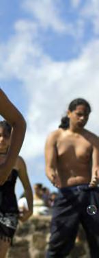
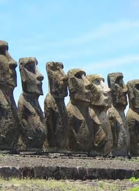
14 12 HAWAII & RAPA NUI Exploring Cultural Connections In December 2012, a group of U.S. coastal and marine managers visited Chile to begin conversations about how the two countries could collaborate on marine and land-based parks. While the managers from both countries saw many connections, those from Hawaiʻi and Rapa Nui (Easter Island) were particularly struck by the cultural, historical, social, ecological, and geologic similarities between these two Polynesian cultures and eager to explore future collaboration. There is an undeniable connection among people who look toward the ocean as the path of their history and geneaology. Despite the thousands of kilometers that separate the islands of Hawaiʻi and Rapa Nui, the ocean connects their cultures. At the far reaches of the Pacific, these isolated archipelagos were both settled around AD and have allowed the ancestral peoples of Hawaiʻi and Rapa Nui to develop distinct variations of Polynesian culture. The ecosystems of Hawaiʻi and Rapa Nui contain some of the highest rates of endemism and have fostered and sustained similarly unique cultural histories. In the Northwestern Hawaiian Islands, a number of stone idols (kiʻi) found on Nihoa and Mokumanamana are described in early historical accounts of Hawaiian culture. These kiʻi are much smaller than the impressive stone moai of Rapa Nui, statues that embody the sacred spirit of ancestors. However, both the moai and kiʻi are thought to have important religious significance and marked the emergence of significant cultural shifts. When the great migrations throughout Polynesia ended hundreds of years ago, these indigenous peoples adapted to local landscapes and their ancestral relationships with the lands and waters continue today. The people of both Hawaiʻi and Rapa Nui have demonstrated a resurgence of cultural pride and identity and self-determination. In 1999, the traditional Hawaiian voyaging canoe, Hōkūleʻa, sailed to the shores of Rapa Nui a tangible reminder of how the ocean connects us. Today, managers and staff at Papahānaumokuākea Marine National Monument and Motu Motiro Hiva Marine Park are exploring these connections and ways to work together to conserve their vibrant marine resources and cultural heritage. Photo: Flickr/Steve Cadman Photos (clockwise from top left): Ki i (carved idols) at Pu uhonua O Hōnaunau National Historical Park; The people of Rapa Nui perform traditional song and dance; The traditional voyaging canoe, Hōkūle a, off the island of O ahu; Ahu Tongariki, the largest ahu (stone paltform) in Rapa Nui; The cliffs of Nihoa from the deck of the traditional voyaging canoe, Hikianalia.


15 13 Photo: Flickr/travelwayoflife Photo courtesy Polynesian Voyaging Society Photo: Brad Wong Photo: Gonzalo Cid/NOAA
16 The National Marine Protected Areas Center is located within NOAA s Office of National Marine Sanctuaries and works with the Department of the Interior to serve as a resource to all federal, state, territorial and tribal programs responsible for the health of the oceans. PRINTED ON RECYCLED PAPER
Underwater Acoustic Monitoring in US National Parks
 Underwater Acoustic Monitoring in US National Parks Megan F McKenna 1, Christopher Garsha 2, Erik Stabenau 1, Christine Gabriele 1, Timothy Clark 1, Clayton Pollock 1, Brinnen Carter 1, Samantha Bietsch
MARINE PROTECTED AREAS LESSON PLAN Water Parks
 Marine Protected Areas U. S. Marine Protected Areas Lesson Plan MARINE PROTECTED AREAS LESSON PLAN Water Parks Theme U.S. Marine Protected Areas Links to Overview Essays and Resources Needed for Student
Alaskan/Fjordland Pacific (Ecoregion 22)
") Alaskan/Fjordland Pacific (Ecoregion 22) Background The Alaskan/Fjordland Pacific Ecoregion is an area of abundant marine resources. The ecoregion begins at Vancouver Island and moves up the Gulf of Alaska
Alaskan/Fjordland Pacific (Ecoregion 22) Background The Alaskan/Fjordland Pacific Ecoregion is an area of abundant marine resources. The ecoregion begins at Vancouver Island and moves up the Gulf of Alaska
Vaikava Rapa Nui Easter Island s Rapa Nui people uphold tradition as guardians of the ocean
 A fact sheet from Sept 2015 Vaikava Rapa Nui Easter Island s Rapa Nui people uphold tradition as guardians of the ocean Easter Island, a territory of Chile that lies some 4,000 kilometers (2,300 miles)
The Pitcairn Islands The world s largest fully protected marine reserve
 A fact sheet from March 2015 The Pitcairn Islands The world s largest fully protected marine reserve Overview In March 2015, the United Kingdom declared the world s largest fully protected marine reserve
U.S. Activities in Puerto Rico, U.S. Virgin Islands and the Wider Caribbean. NOAA and the US Coral Reef Task Force
 U.S. Activities in Puerto Rico, U.S. Virgin Islands and the Wider Caribbean NOAA and the US Coral Reef Task Force U.S. Coral Reef Task Force Co-Chairs: National Oceanic and Atmospheric Administration (NOAA)
Twelve Apostles Marine National Park Australia
 EVALUATION REPORT Twelve Apostles Marine National Park Australia Location: Victoria, Australia coastal waters Global Ocean Refuge Status: Nominated (2017), Evaluated (2017) MPAtlas.org ID: 7703885 Manager(s):
Our Mission: Our Goals:
 Our Mission: Reef Relief is a nonprofit membership organization dedicated to improving and protecting our coral reef ecosystem. Our programs instill an attitude of stewardship in boaters, divers, fishermen
Virginian Atlantic (Ecoregion 8)
") Virginian Atlantic (Ecoregion 8) Background The Virginian Atlantic Ecoregion extends from the south side of Cape Cod to Cape Hatteras in North Carolina. The waters of the ecoregion are a mix of cold and
Virginian Atlantic (Ecoregion 8) Background The Virginian Atlantic Ecoregion extends from the south side of Cape Cod to Cape Hatteras in North Carolina. The waters of the ecoregion are a mix of cold and
What is an Marine Protected Area?
 Policies, Issues, and Implications of Marine Protected Areas Kara Anlauf University of Idaho Before the House Subcommittee on Fisheries Conservation, Wildlife and Oceans April 29, 2003 What is an Marine
AGENCY: Office of National Marine Sanctuaries (ONMS), National Ocean Service (NOS),
, National Ocean Service (NOS),") This document is scheduled to be published in the Federal Register on 01/24/2018 and available online at https://federalregister.gov/d/2018-01271, and on FDsys.gov 3510-NK DEPARTMENT OF COMMERCE National
This document is scheduled to be published in the Federal Register on 01/24/2018 and available online at https://federalregister.gov/d/2018-01271, and on FDsys.gov 3510-NK DEPARTMENT OF COMMERCE National
Papahānaumokuākea Marine National Monument U.S.A.
 EVALUATION REPORT Papahānaumokuākea Marine National Monument U.S.A. Location: Northwestern Hawaiian Islands, Pacific Ocean Global Ocean Refuge Status: Nominated (2017), Evaluated (2017) MPAtlas.org ID:
REGIONAL AGREEMENT AND FRAMEWORK FOR MARINE MAMMALS CONSERVATION IN THE WCR: THE SPAW PROTOCOL AND THE MARINE MAMMAL ACTION PLAN
 REGIONAL AGREEMENT AND FRAMEWORK FOR MARINE MAMMALS CONSERVATION IN THE WCR: THE SPAW PROTOCOL AND THE MARINE MAMMAL ACTION PLAN ALESSANDRA VANZELLA-KHOURI SPAW Programme Officer United Nations Environment
Palau National Marine Sanctuary Building Palau s future and honoring its past
 A fact sheet from Sept 2015 Palau National Marine Sanctuary Building Palau s future and honoring its past Caring for the environment has long been an important part of Palau s culture. For centuries, traditional
The Regional Coral Reef Task Force and Action plan. 27 th ICRI. Cairns Australia July 2012
 The Regional Coral Reef Task Force and Action plan 27 th ICRI Cairns Australia July 2012 Western Indian Ocean Region East Africa mainland states Indian Ocean Islands states Biogeographic division of the
GLOBAL LEADERS IN BUILDING EFFECTIVE MARINE PROTECTED AREAS
 GLOBAL LEADERS IN BUILDING EFFECTIVE MARINE PROTECTED AREAS Marine protected areas (MPAs) like national parks on land set aside dedicated areas for conservation to help the ocean thrive, provide jobs,
An unparalleled opportunity. Creating marine reserves in the UK Overseas Territories
 An unparalleled opportunity Creating marine reserves in the UK Overseas Territories July 2012 An unparalleled opportunity Creating marine reserves in the UK Overseas Territories Who are the Pew Charitable
Unit 1 Lesson 1: Introduction to the Dry Tortugas and Sustainable Seas Expedition
 Unit 1 Lesson 1: Introduction to the Dry Tortugas and Sustainable Seas Expedition Lesson Objectives: Introduce students to the historical, geographic, and ecological importance of the Dry Tortugas. Introduce
TRANSATLANTIC PLATFORM FOR ACTION ON THE GLOBAL ENVIRONMENT (T-PAGE) 1. Background Paper on US Marine Protected Areas (MPAs)
 1. Background Paper on US Marine Protected Areas (MPAs)") TRANSATLANTIC PLATFORM FOR ACTION ON THE GLOBAL ENVIRONMENT (T-PAGE) 1 Background Paper on US Marine Protected Areas (MPAs) June 2007 Authors: Melanie Nakagawa, Attorney, International Program Kate Wing,
TRANSATLANTIC PLATFORM FOR ACTION ON THE GLOBAL ENVIRONMENT (T-PAGE) 1 Background Paper on US Marine Protected Areas (MPAs) June 2007 Authors: Melanie Nakagawa, Attorney, International Program Kate Wing,
TOWARDS SUSTAINABLE MANAGEMENT OF MARINE AND COASTAL HABITATS ASIA- PACIFIC DAY FOR THE OCEAN
 TOWARDS SUSTAINABLE MANAGEMENT OF MARINE AND COASTAL HABITATS WANNAKIAT THUBTHIMSANG PHUKET MARINE BIOLOGICAL CENTER, DMCR, THAILAND ASIA- PACIFIC DAY FOR THE OCEAN 20 NOVEMBER 2018, CONFERENCE ROOM 4,
LATIN AMERICA / CARIBBEAN COIBA NATIONAL PARK PANAMA
 LATIN AMERICA / CARIBBEAN COIBA NATIONAL PARK PANAMA WORLD HERITAGE NOMINATION IUCN TECHNICAL EVALUATION COIBA NATIONAL PARK (PANAMA) ID Nº 1138 Bis Background note: Coiba National Park was nominated for
Coral Reefs: Integrative Teaching Tool (and Guide to NOAA Resources) National Science Teachers Association April 6, 2006 Anaheim, California
 National Science Teachers Association April 6, 2006 Anaheim, California") Coral Reefs: Integrative Teaching Tool (and Guide to NOAA Resources) National Science Teachers Association April 6, 2006 Anaheim, California NOAA Coral Reef Conservation Program: Created by NOAA in 2000
Coral Reefs: Integrative Teaching Tool (and Guide to NOAA Resources) National Science Teachers Association April 6, 2006 Anaheim, California NOAA Coral Reef Conservation Program: Created by NOAA in 2000
Bon Portage Island Conservation Campaign
 Bon Portage Island Conservation Campaign Protecting a Coastal Treasure Final Report to Nova Scotia Habitat Conservation Fund September 2012 Protection of Bon Portage Island Over the course of this two-year
Questions and Answers
 Home The Region Questions & Answers Documents Maps & Imagery Reserve Council Public Comment Search This Site About This Site Questions and Answers 1. Why is the President making this announcement? 2. What
National Park Service Wilderness Action Plan
 National Park Service U.S. Department of the Interior National Park Service Wilderness Action Plan National Wilderness Steering Committee National Park Service "The mountains can be reached in all seasons.
Buck Island Reef National Monument News Release Date: Immediate Contact: Joel Tutein, Superintendent, x 222
 National Park Service U.S. Department of the Interior www.nps.gov 2100 Church Street, # 100 Christiansted, VI 00820 News Release Date: Immediate Contact: Joel Tutein, Superintendent, Joel.Tutein@nps.gov
Kermadec. Ocean Sanctuary
 Kermadec Ocean Sanctuary Kermadec Ocean Sanctuary, New Zealand Pacific Remote Islands National Marine Monument, United States Coral Sea Marine Reserve, Australia Proposed Pitcairn Marine Reserve, United
Public Lands in Alaska. 200 million acres of federal land - Over 57 Million acres of Wilderness more than half the Wilderness in the entire nation
 Public Lands in Alaska 200 million acres of federal land - Over 57 Million acres of Wilderness more than half the Wilderness in the entire nation alaskawild.org Ground Zero for Climate Change Over the
UNESCO s World Heritage Program California Current Conservation Complex
 Office of National Marine Sanctuaries National Oceanic and Atmospheric Administration UNESCO s World Heritage Program California Current Conservation Complex William Douros Regional Director NOAA's Office
Overview CARIBBEAN MARINE BIODIVERSITY PROGRAM
 CARIBBEAN MARINE BIODIVERSITY PROGRAM Overview The Caribbean Marine Biodiversity Program is a five-year project (2014-2019), funded by the U.S. Agency for International Development and The Nature Conservancy,
PROUDLY BRINGING YOU CANADA AT ITS BEST. Management Planning Program NEWSLETTER #1 OCTOBER, 2000
 PROUDLY BRINGING YOU CANADA AT ITS BEST VUNTUT NATIONAL PARK Management Planning Program NEWSLETTER #1 OCTOBER, 2000 INTRODUCTION This newsletter launches the development of the first management plan for
The Caribbean Marine Protected Managers Network and Forum (CaMPAM) M ENTO RSH I P PRO G RAM MENTOR BIOGRAPHIES
 M ENTO RSH I P PRO G RAM MENTOR BIOGRAPHIES") The Caribbean Marine Protected Managers Network and Forum (CaMPAM) M ENTO RSH I P PRO G RAM Mr. Majil is currently the MPA Coordinator for the country of Belize, a position he has held since 2002. He previously
The Caribbean Marine Protected Managers Network and Forum (CaMPAM) M ENTO RSH I P PRO G RAM Mr. Majil is currently the MPA Coordinator for the country of Belize, a position he has held since 2002. He previously
How South Africa is making progress towards the Aichi 2020 Target 11
 How South Africa is making progress towards the Aichi 2020 Target 11 Montreal, Canada 2 May 2016 Oceans and Coasts Content Protected area considerations and progress 1994-2010 Terrestrial Protected Area
Ocho Rios, Jamaica GEF-IWCAM AND IABIN INDICATORS MECHANISM WORKSHOP March TNC s Marine Protected Area Work.
 TNC s Marine Protected Area Work in the Caribbean GEF-IWCAM AND IABIN INDICATORS MECHANISM WORKSHOP 10-12 March 2008 Ocho Rios, Jamaica Caribbean Decision-Support System 3 years (2003-2006) $2.2 million
Adapting to climate change by promoting sustainable livelihoods, human and food security, and resilient ecosystems
 Adapting to climate change by promoting sustainable livelihoods, human and food security, and resilient ecosystems ICRI Indian Ocean Day December 13, 2011 Regional Challenges Atlantic Caribbean Challenge
Saving Sharks Proposing a New Marine Protected Area
 Saving Sharks Proposing a New Marine Protected Area What would be the ideal characteristics of a marine protected area designed to conserve white sharks in the Pacific Ocean? Learning Objectives Describe
Terrestrial Protected Area Nomination: Central Mangrove Wetland South-West, Grand Cayman
 Terrestrial Protected Area Nomination: Central Mangrove Wetland South-West, Grand Cayman The attached nomination, proposing that a parcel of land in the Central Mangrove Wetland be made a Protected Area
Biosphere Reserves of India : Complete Study Notes
 Biosphere Reserves of India : Complete Study Notes Author : Oliveboard Date : April 7, 2017 Biosphere reserves of India form an important topic for the UPSC CSE preparation. This blog post covers all important
Protected Areas & Ecotourism
 Protected Areas & Ecotourism IUCN Best Practice Guidelines, tools & protected area/ecotourism highlights from around the world Kathy Zischka, Director Annual General Meeting Australian 2 November Committee
Member s report on activities related to ICRI
 Member s Report INTERNATIONAL CORAL REEF INITIATIVE (ICRI) 32 nd General Meeting 7-9 December 2017 Nairobi, Kenya Member s report on activities related to ICRI MALAYSIA Reporting period November November
Sizing up Australia s eastern Grey Nurse Shark population
 Image: David Harasti A new estimate of adult population size for Australia s eastern Grey Nurse Shark drew on widespread genetic sampling and forensic exploration of family trees. Grey Nurse Sharks are
Michipicoten Island Regional Plan
 Michipicoten Island Regional Plan This is one of twenty Regional Plans that support implementation of the Lake Superior Biodiversity Conservation Strategy (Strategy). The Strategy, prepared and overseen
Access: The rocky shoreline is only accessible via private property.
 10. Whale Cove Site description: Whale Cove is a small cove fringed by private homes and condominiums with diverse and relatively undisturbed rocky intertidal and subtidal habitat located approximately
Tourism and Wetlands
 CONVENTION ON WETLANDS (Ramsar, Iran, 1971) 43 rd Meeting of the Standing Committee Gland, Switzerland, 31 October 4 November 2011 DOC. SC43-27 Tourism and Wetlands Action requested. The Standing Committee
Cayman sharks and dolphins. Do the Cayman Islands need Protective Legislation?
 V5 PUBLIC CONSULTATION August 2012 Cayman sharks and dolphins The purpose of this document is to summarise key findings from a study of sharks, rays, whales and dolphins in Cayman, and to open a public
Malpelo Fauna and Flora Sanctuary Colombia
 EVALUATION REPORT Malpelo Fauna and Flora Sanctuary Colombia Location: South Pacific Global Ocean Refuge Status: Nominated (2017), Evaluated (2017) MPAtlas.org ID: 3803 Manager(s): Nancy Murillo Bohórquez
BROUGHTON ARCHIPELAGO PROVINCIAL PARK
 BROUGHTON ARCHIPELAGO PROVINCIAL PARK PURPOSE STATEMENT AND ZONING PLAN March 2003 BROUGHTON ARCHIPELAGO PROVINCIAL PARK Purpose Statement and Zoning Plan Primary Role The primary role is to contribute
British Columbia s Great Bear Rainforest - Fall Edition. Discover Abundant wildlife, and ancient forest ecosystems
 British Columbia s Great Bear Rainforest - Fall 2019 Edition 9-days exploring the largest intact coastal temperate rainforest in the world. Discover Abundant wildlife, and ancient forest ecosystems Encounter
Galveston Bay Estuary Program. Carla G. Guthrie, Ph.D. Galveston Bay Council Member Texas Water Development Board
 Galveston Bay Estuary Program Carla G. Guthrie, Ph.D. Galveston Bay Council Member Texas Water Development Board The statements contained in this presentation are my current views and opinions and are
Coral reef management for sustainable development
 Coral reef management for sustainable development 2015 Australian Fellowship Program Building capacity to protect coral reefs as a foundation for sustainable development and ecosystem based adaptation
Great Lakes Association of Science Ships Annual Meeting, Traverse City, MI 11 Jan 11
 Great Lakes Association of Science Ships Annual Meeting, Traverse City, MI 11 Jan 11 Dr. Marie Colton Director NOAA Great Lakes Environmental Research Lab Ann Arbor, MI Dennis Donahue Marine Superintendent
The Ecology and Economy of Coral Reefs: Considerations in Marketing Sustainability
 The Ecology and Economy of Coral Reefs: Considerations in Marketing Sustainability Rick MacPherson Director, Conservation Programs Coral Reef Alliance Coral Reefs in Peril: Worldwide Status 2004: 70% of
Contribution of Marine Protected Areas to the Blue Economy and Sustainable Fisheries
 2015/HLPD-FSBE/012 Session: 1 Contribution of Marine Protected Areas to the Blue Economy and Sustainable Fisheries Purpose: Information Submitted by: Philippines High Level Policy Dialogue on Food Security
An NPS Wetland of International Significance!
 An NPS Wetland of International Significance! A World Class Tourism Destination Linda Friar Chief of Public Affairs 305-242-7714 Linda_Friar@nps.gov The Everglades - International Recognition as a special
Tubbataha Reefs Natural Park Philippines
 EVALUATION REPORT Tubbataha Reefs Natural Park Philippines Location: Cagayancillo, Palawan, Philippines; Sulu Sea, Pacific Ocean Global Ocean Refuge Status: Nominated (2017), Evaluated (2017) MPAtlas.org
[Type text] [Type text] [Type text]
![[Type text] [Type text] [Type text]](/thumbs/83/88153521.jpg "[Type text] [Type text] [Type text]") Camp Nautilus Camp Nautilus is located in the region of Kenting National Park(http://www.ktnp.gov.tw/), is partnership between Scouts of China and National Museum of Marine Biology & Aquarium (http://www.nmmba.gov.tw/english/index.aspx)
Camp Nautilus Camp Nautilus is located in the region of Kenting National Park(http://www.ktnp.gov.tw/), is partnership between Scouts of China and National Museum of Marine Biology & Aquarium (http://www.nmmba.gov.tw/english/index.aspx)
Informational Report 1 September 2016
 Informational Report 1 September 2016 Proposal for Addition to U.S. Tentative List for World Heritage CALIFORNIA CURRENT CONSERVATION COMPLEX June 8, 2016 Working Name of Site California Current Conservation
Environmental Learning Outside the Classroom (ELOC)
") Environmental Learning Outside the Classroom (ELOC) This guidebook provides lesson ideas and activities to get students engaged with outdoor learning. Created by the Virgin Islands Marine Advisory Service
Environmental Learning Outside the Classroom (ELOC) This guidebook provides lesson ideas and activities to get students engaged with outdoor learning. Created by the Virgin Islands Marine Advisory Service
Proposed National Marine Conservation Area Reserve Southern Strait of Georgia PROJECT UPDATE Spring 2012
 Proposed National Marine Conservation Area Reserve Southern Strait of Georgia PROJECT UPDATE Spring 2012 National marine conservation areas (NMCAs) are established to protect, conserve and present examples
Nazca-Desventuradas: Chile s New Marine Reserve
 By: Sara Jones, Research Associate Council on Hemispheric Affairs At the 2015 Our Ocean Conference, Chilean president Michelle Bachelet announced the creation of a new marine park off the coast of Chile,
SCALING AND AMPLIFYING MPAS FOR THE EFFECTIVE CONSERVATION OF THE CENTER OF CENTER OF MARINE BIODIVERSITY,
 SCALING AND AMPLIFYING MPAS FOR THE EFFECTIVE CONSERVATION OF THE CENTER OF CENTER OF MARINE BIODIVERSITY, THE VERDE ISLAND PASSAGE A. Rex F. Montebon, Ph.D. 2015 EAS Congress Furama Resort, Danang, Vietnam
Aquatic insect surveys at Mount Magazine State Park and Hobbs State Park Conservation Area with implementation of an educational component
 Aquatic insect surveys at Mount Magazine State Park and Hobbs State Park Conservation Area with implementation of an educational component Arkansas is home to a relatively large number of endemic invertebrates
IMO ROUTEING OF SHIPS, SHIP REPORTING AND RELATED MATTERS. Submitted by the World Wide Fund for Nature (WWF) NAV 52/3/6 and NAV 52/3/6/Corr.
 NAV 52/3/6 and NAV 52/3/6/Corr.") INTERNATIONAL MARITIME ORGANIZATION E IMO SUB-COMMITTEE ON SAFETY OF NAVIGATION 52nd session Agenda item 3 NAV 52/INF.9 26 May 2006 ENGLISH ONLY ROUTEING OF SHIPS, SHIP REPORTING AND RELATED MATTERS Submitted
INTERNATIONAL MARITIME ORGANIZATION E IMO SUB-COMMITTEE ON SAFETY OF NAVIGATION 52nd session Agenda item 3 NAV 52/INF.9 26 May 2006 ENGLISH ONLY ROUTEING OF SHIPS, SHIP REPORTING AND RELATED MATTERS Submitted
Coverage of Mangrove Ecosystem along Three Coastal Zones of Puerto Rico using IKONOS Sensor
 Coverage of Mangrove Ecosystem along Three Coastal Zones of Puerto Rico using IKONOS Sensor Jennifer Toledo Rivera Geology Department, University of Puerto Rico, Mayagüez Campus P.O. Box 9017 Mayagüez,
Riding the Wave. Building Momentum for the Ocean from World Parks Congress. Dan Laffoley Marine Vice Chair IUCN s World Commission on Protected Areas
 Riding the Wave Building Momentum for the Ocean from World Parks Congress Dan Laffoley Marine Vice Chair IUCN s World Commission on Protected Areas Marine Goals Planning for Sydney Protect More PROMISE
Department of Environment and Natural Resources
 Department of Environment and Natural Resources Brad Ives Assistant Secretary for Natural Resources brad.ives@ncdenr.gov 919-707-8620 Mitch Gillespie Assistant Secretary for Environment mitch.gillespie@ncdenr.gov
The Vision for the San Juan Islands Scenic Byway
 The Vision for the San Juan Islands Scenic Byway 2 Judd Cove, Orcas Island, Courtesy of Kurt Thorson (kurtthorson.com) and San Juan County Land Bank Vision for the San Juan Islands Scenic Byway The San
COMMUNICATION AND AWARENESS-RAISING STRATEGY
 MEMORANDUM OF UNDERSTANDING ON THE CONSERVATION OF MIGRATORY SHARKS CMS/Sharks/Outcome 3.5 14 December 2018 3 rd Meeting of the Signatories (Sharks MOS3) Monaco, 10 14 December 2018 COMMUNICATION AND AWARENESS-RAISING
A Proposed Framework for the Development of Joint Cooperation On Nature Conservation and Sustainable Tourism At World Heritage Natural sites.
 Introduction: A Proposed Framework for the Development of Joint Cooperation On Nature Conservation and Sustainable Tourism At World Heritage Natural sites Between The tourism industry and the UNESCO, World
ECORREGIONAL ASSESSMENT: EASTERN CORDILLERA REAL ORIENTAL PARAMOS AND MONTANE FORESTS
 ECORREGIONAL ASSESSMENT: EASTERN CORDILLERA REAL ORIENTAL PARAMOS AND MONTANE FORESTS The Nature Conservancy, EcoCiencia y Fundación AGUA. 2005. Evaluación Ecorregional de los Páramos y Bosques Montanos
World Heritage Site 1. World Heritage Site 2 OCEANIA
 World Heritage Site 1 This site is managed by both the national government of this country in the southern hemisphere and the native people who have lived here for thousands of years. Tidal plains, lowlands,
Workshop on Guiana Shield Biodiversity Corridor to streamline support for the achievement of the Aichi Biodiversity Targets
 Workshop on Guiana Shield Biodiversity Corridor to streamline support for the achievement of the Aichi Biodiversity Targets ACTION PLAN Preamble: We, the participants of the workshop called, Guiana Shield
MARINE PROTECTED AREA IN MALAYSIA
 MARINE PROTECTED AREA IN MALAYSIA AB RAHIM GOR YAMAN Director, Division of Planning and Management Department of Marine Park Ministry of Natural Resources and Environment abrahim@nre.gov.my History of
VARGAS ISLAND PROVINCIAL PARK
 VARGAS ISLAND PROVINCIAL PARK PURPOSE STATEMENT AND ZONING PLAN February 2003 VARGAS ISLAND PROVINCIAL PARK Purpose Statement and Zoning Plan Primary Role The primary role of Vargas Island Park is to protect
East Pacific hub. An area larger than continental Europe with over 120 islands and 20% of the world s atolls on the front line of climate change
 2 entities (FR / EN ) An area larger than continental Europe with over 120 islands and 20% of the world s atolls on the front line of climate change Results from ecosystem profiling in French Polynesia
Malpelo Fauna and Flora Sanctuary Colombia
 EVALUATION REPORT Malpelo Fauna and Flora Sanctuary Colombia Location: South Pacific Global Ocean Refuge Status: Nominated (2017), Evaluated (2017) MPAtlas.org ID: 3803 Manager(s): Paola Andrea Rojas Malagón,
World Heritage Marine Programme
 World Heritage Marine Programme Launched in 2005, the mission of the World Heritage Marine Programme is to establish effective conservation of existing and potential marine areas of Outstanding Universal
The Partnership Wild & Scenic Rivers Program
 BUDGET REQUEST FISCAL YEAR 2017 Proven, cost-effective protection for 770 miles of rivers and thousands of acres of riparian land Westfield River, MA (L) and Farmington River, CT (R) Partnership Wild &
APPENDIX A TERMS OF DESIGNATION
 247 248 ABOUT THIS DOCUMENT On May 11, 1994 the National Oceanic and Atmospheric Administration (NOAA) published the final Olympic Coast National Marine Sanctuary Regulations (59 FR 24586). This official
Spatial Distribution and Characteristics of At-Risk Species in the Southeast U.S.
 Nicholas Institute for Environmental Policy Solutions Scoping Document Part 2 Exploratory Analysis of Characteristics and Trends of At-Risk Species in the Southeast U.S. Spatial Distribution and Characteristics
REDD+ IN YUCATAN PENINSULA
 REDD+ IN YUCATAN PENINSULA JOINING FORCES TO PRODUCE AND PRESERVE 2 3 Campeche, Yucatan, and Quintana Roo combat deforestation together in the Yucatan Peninsula and build a new path for growth A peninsular
Global Ocean Legacy Working together to create the world s first generation of great parks in the sea
 A fact sheet from Aug 2015 Global Ocean Legacy Working together to create the world s first generation of great parks in the sea Overview The ocean plays an essential role in sustaining life on our planet.
W O R L D H E R I T A G E
 WORLD HERITAGE p r o g r a m m e p r o g r a m m Currently only 31 sites on the World Heritage List contain a marine component. Therefore, the World Heritage Centre, as the Secretariat of the World Heritage
Vietnam Marine Protected Area Management Effectiveness Evaluation
 Vietnam Marine Protected Area Management Effectiveness Evaluation 5 th EAS Congress (16-21 November, 2015) Bui Thi Thu Hien IUCN Viet Nam Marine Protected Areas: Global Status There are over 161,000 protected
Alessandra Vanzella-Khouri, SPAW Secretariat Helene Souan, Director, SPAW-RAC
 UNEP s Caribbean Environment Programme (CEP) The Specially Protected Areas and Wildlife Protocol (SPAW) and the Regional Activity Centre for SPAW Protocol (SPAW RAC) Alessandra Vanzella-Khouri, SPAW Protocol
ICRI Monaco January 2010
 Economic Valuation of Coral Reefs in the Caribbean ICRI Monaco January 2010 Lauretta Burke World Resources Institute (WRI) Beautiful Valuable Valuable Valuable Valuable Valuable Photos: Krishna Desai Valuable
The Egadi Islands Marine Protected Area: a laboratory for the sustainable management of coast and sea
 The Marine Protected Area: a laboratory for the sustainable management of coast and sea Dr. Stefano Donati, Director at M.P.A. The Egadi s archipelago is located in the Strait of Sicily, and includes the
U.S. Support to the Coral Triangle Initiative Monthly Program Update November 2012
 12.15.12 U.S. Support to the Monthly Program Update November 2012 Supporting countries of the Coral Triangle region to sustain their marine resources IN THIS ISSUE Solomon Islands Launches Innovative Mobile
Congratulations on the completion of your project that was supported by The Rufford Small Grants Foundation.
 The Rufford Small Grants Foundation Final Report Congratulations on the completion of your project that was supported by The Rufford Small Grants Foundation. We ask all grant recipients to complete a Final
Elkhorn Slough Tidal Wetland Project
 Elkhorn Slough Tidal Wetland Project Joint Meeting Strategic Planning Team and Science Panel September 23, 2009 Funding National Oceanic and Atmospheric Admin. David and Lucille Packard Foundation Resources
Community-based tourism at Gunung Halimun National Park
 Asia-Pacific Environmental Innovation Strategies (APEIS) Research on Innovative and Strategic Policy Options (RISPO) Good Practices Inventory Community-based tourism at Gunung Halimun National Park Summary
T O U R I S M P L A N 2020
 T O U R I S M P L A N 2020 2 CITY OF HOLDFAST BAY TOURISM PLAN 2020 CONTENTS Executive Summary 4 Introduction 7 Tourism at a State and National Level 7 Tourism in the City of Holdfast Bay 7 Our Focus 8
The American Legacy of Wilderness
 National Wilderness Conference Albuquerque, New Mexico October 15 19, 2014 The American Legacy of Wilderness Honoring 50 Years of Preservation, Use, and Enjoyment 1 www.wilderness50th.org For a Half-Century
IOC Intergovernmental Coordination Group for the Tsunami and Other Coastal Hazards Warning System for the Caribbean and Adjacent Regions
 UNESCO IOC CTIC US NOAA ITIC Regional Training Workshop on Strengthening Tsunami Warning and Emergency Response Standard Operating Procedures and the Development of the ICG/CARIBE-EWS PTWC New Enhanced
Project Concept Note
 North-East Asian Subregional Programme for Environmental Cooperation (NEASPEC) 1. Overview 1. Project Title 2. Goals Project Concept Note Study on Transborder Movement of Amur Tigers and Leopards using
Satoquo SEINO (Graduate School of Engineering, Kyushu University, Japan)
") A reconsideration of horseshoe crab conservation methodology in Japan over the last 100 years and prospects for a marine protected area network in Asian seas Satoquo SEINO (Graduate School of Engineering,
A reconsideration of horseshoe crab conservation methodology in Japan over the last 100 years and prospects for a marine protected area network in Asian seas Satoquo SEINO (Graduate School of Engineering,
 SUMMARY GUIDE to the SANCTUARY MANAGEMENT PLAN New Sanctuary Management Plan Available The NOAA Office of National Marine Sanctuaries has updated the management plan for the Fagatele Bay National Marine
Project : Marine Ecology Research Center (MERC) Sabah, Malaysia
 Sabah, Malaysia") Project : Marine Ecology Research Center (MERC) Sabah, Malaysia Table of contents 1) Introduction of Malaysia 2) Malaysia Map & Location of MERC 3) Introduction of MERC 4) Activities of MERC 4.1) Active
Project : Marine Ecology Research Center (MERC) Sabah, Malaysia Table of contents 1) Introduction of Malaysia 2) Malaysia Map & Location of MERC 3) Introduction of MERC 4) Activities of MERC 4.1) Active
Bering Sea Ecoregion Strategic Action Plan
 Bering Sea Ecoregion Strategic Action Plan Part I Map by Shane T. Feirer The Nature Conservancy in Alaska First Iteration September 2005 Part 1. Bering Sea Ecoregion: Strategic Action Plan - First Iteration
3.10 BIOLOGICAL RESOURCES
 3.10 BIOLOGICAL RESOURCES The isolated nature and volcanic origin of the Hawaiian Islands has resulted in a truly unique diversity of habitats and species. Hawai i s habitats range from alpine deserts