2. Public Comments. c. d. River Road e. f. Participation in members of the. locations. utilized. Action. Discussion/Action
|
|
|
- Reynold Mathews
- 5 years ago
- Views:
Transcription


1 SAN JOAQUIN COUNTY MULTI-SPECIESS HABITAT CONSERVATION AND OPEN SPACEE PLAN HABITAT TECHNICAL ADVISORY COMMITTEE MEETING San Joaquin Council of Governments Regional Center Building 555 E. Weber Avenue Stockton, CA Participation in the meeting may be available for Committee Members attending the HTAC meeting by Conference Call and members of the public, pursuant to California Government Code Sectionn 54953(b), at one or more of the following locations. Please contact Steve Mayo at (209) prior to the meeting to determine which locations are utilized. City of Tracy 333 Civic Center Tracy, CA City of Lodi 221 W. Pine Street Lodi, CA City of Ripon 259 Wilma Avenue Ripon, CA SJ Ag Commissioner 2101 Earhart Avenue Stockton, CA City of Lathrop 390 Towne Center Drive Lathrop, CA SJ County 1810 Hazelton Avenue Stockton, CA City of Mantecaa 1001 W. Center Drive Manteca, CA City of Escalon 2060 McHenry Avenue Escalon, CA Wednesday, November 9, :30 A.M. Board Conference Room AGENDA 1. Call to Order / Introductions 2. Minutes: Approve Minutes of September 14, Public Comments Action All technical items are available for action by the committee. The right column is recommendations by staff. 4. Consent Calendar: a. Small Farms Improvement Tract, Private Right-of-Way Project b. CA Village Farm Tract, Private Right-of-Way Project c. Whitaker Tract, Private Right-of-Way Project d. River Road Warehouse Building Project e. Franzia Winery Expansionn Project Wilson Family Winery Expansion Project f. 5. Other Matters of Business: a SJMSCP Fee Adoption Update b. HTAC December meeting c. SJMSCP General Update 6. Summary and Adjournment of HTAC Meeting Information/Discussion HTAC PRESERVE MANAGEMENT PLAN SUB-COMMITTEE MEETING To be held approximately10 minutes after adjournment of HTAC 1. Call to Order / Introductions 2. Public Comments 3. SJMSCP PMP Review Discussion/Action 4. Summary and Adjournment For your convenience, parking is available at the COG Regional Center marked Visitor on the East Side of the Parking Lot. There is additional parking available at Public Parking Lot K, located on American Street, just south of Weber Avenue. Additional meter parking on Weber Avenue.
2 The San Joaquin Council of Governments is in compliance with the Americans with Disabilities Act and will make all reasonable accommodations for persons with disabilities to participate in employment, programs, and access facilities. Persons requiring assistance or auxiliary aid in order to participate should contact Rebecca Montes at (209) at least 24 hours prior to the meeting.
3 San Joaquin Multi-Species Habitat Conservation and Open Space Plan Habitat Technical Advisory Committee San Joaquin Council of Governments 555 East Weber Avenue Stockton, CA Wednesday, September 14, 2016 MINUTES I. Call to Order/Introductions Ms. Hatef called the meeting to order at 9:35 am introductions were made. Committee Members Present or Conference Call: Mo Hatef San Joaquin County Rebecca Willis City of Lathrop Craig Hoffman City of Lodi Mandy Kang City of Manteca Ken Zuidervaart City of Ripon Dominique Romo City of Escalon John Beckman BIA Kursten Sheridan CA Dept. Fish and Wildlife Josh Emery USFWS Barbara Huecksteadt SJC Ag Commission Dan Gifford Conservation James Jones EBMUD SJCOG Staff/Consultants Present: Steve Mayo Program Manager Laurel Boyd Assistant Habitat Planner Doug Leslie ICF Jones & Stokes Monica Streeter Neumiller & Beardslee II. Approval of August 10, 2016 Minutes: It was moved/second (Emery/Jones) to accept the minutes of August 10, Motion passed 9/0. III. Public Comment: None.
4 IV. Consent Calendar: a. Hammer Lane Phase 3 Giant Garter Snake (GGS)/Western Pond Turtle (WPT) Buffer Reduction It was moved/seconded (Beckman/Emery) to approve the Consent Calendar. Motion passed 9/0. V SJMSCP Development Fees Mr. Mayo stated in March 2016, the SJCOG, Inc. Board adopted the 5-year financial analysis update to the San Joaquin County Multi-Species Habitat Conservation and Open Space Plan (SJMSCP) recommended by the Habitat Technical Advisory Committee (HTAC) Financial Subcommittee, HTAC and SJCOG, Inc. staff. The goal of the update was to review the adopted model which estimates the cost of implementation for fulfillment of the SJMSCP permits and defines the three fee categories Acquisition, Enhancement, and Land Management/Administration and to update and refine the analysis as indicated during the course of review with staff and the HTAC Financial Subcommittee. Mr. Mayo continued to state Table 1 in the staff report illustrates the 2017 SJMSCP Development Fees, which shows the 14% fee increase in Multi-Purpose Open Space, Agricultural and Natural habitat classifications from the prior year primarily related to the large increase of the land acquisition component of Category A s land sale prices in the Central and Delta Primary Zones. The Vernal Pool habitat classifications rose because of the current enhancement and restoration costs associated with the creation of those habitat types. Table 2 of the staff report shows the 2016 fee comparison. Mr. Mayo stated projects who participate under the SJMSCP have the benefit of a predetermined streamlined processing of projects. Projects can choose a various number of ways to provided mitigation for the impacts of the project through the plan and even control the majority of the mitigation costs if desired. The options include, paying the SJMSCP fee; redesigning the project to avoid or minimize impacts; provide land in lieu of paying the SJMSCP fee; or a combination of any of those options. Mr. Mayo continued to state Category A is directly related to comparable land sales in San Joaquin County in specified zones of the plan area, such as Central and Delta Zones over an established 2-year period. Category A saw a 31% increase. During the Financial Analysis Update changes in the criteria to determine comparable land sales changed, which include: 1. Maximizing the ceiling of acreage in the comparable land sales; 2. Using a 24-month set of comparable sales to current market values;
5 3. Using SJCOG, Inc. appraisals to indicate the value of the property in the before condition and the value of the property encumbered by the SJCOG, Inc. easement. Using a 70% value of fee title. 4. Future annual fee analyses will be based on permit term left on the permits and mitigation required for moving forward rather than the 50-year term and full mitigation acreage from the beginning of the plan. Mr. Mayo stated Category B changes include updated and refined cost factors for biological site assessments and preserve enhancements and management planning, and preserve enhancement unit costs that reflect current assessment of enhancement potential and enhancement practices for different types of preserve lands. Annual cost updates will continue to use the California Consumer Price Index (CPI) as reported by the California Department of Finance, for the preceding 12-month fiscal year to keep up with inflation on an annual basis. The calculation results for Category B showed an increase of 4%. Mr. Mayo continued to state Category C changes included refined monitoring cost factors and updated management and administration cost factors that are based on the analysis of SJCOG, Inc. spending in these categories. The annual cost updates also used the California Consumer Price Index (CPI) to keep up with inflation on an annual basis. The calculation resulted in a decrease of 59% in the Agricultural and Natural habitat types in Category C from prior years. Mr. Mayo stated SJCOG, Inc. staff calculated fees using the SJMSCP Financial Analysis formula model. The overall result in the fee analysis consists of a 14% increase in the Multi-Purpose, Agricultural, and Natural habitat classifications fees for It was moved/seconded (Hoffman/Beckman) to Recommend to SJCOG, Inc. Approval of the 2017 SJMSCP Development Fees as Adjusted Pursuant to Comparable Land Sales and Consumer Price Index. Dan Gifford, Conservation abstained. VI. Other Matters of Business a. SJMSCP Board Workshop Thursday, September 15 th Mr. Mayo stated on Thursday, September 15, 2016 at 7:30 am, SJCOG, Inc. staff will be hosting a workshop to provide the SJCOG, Inc. Board with an overview of the Habitat Plan. b. Habitat Conservation Planning from Tahoe to the Bay Symposium Wednesday, October 19 th Mr. Mayo stated the Northern California Conservation Planning Partners will be hosting the fourteenth annual workshop on habitat conservation planning in Vacaville on Wednesday, October 19 th from 9:00 am to 3:45 pm.
6 This item was for information/discussion only, no action was taken. VII. Summary and adjournment: At 10:03 am the meeting was adjourned until November 9, 2016.
7 November 2016 HTAC STAFF REPORT SUBJECT: RECOMMENDED ACTION: Small Farms Improvements Tract, Private Right-of-Way Project Motion to Approve Recommendation to SJCOG, Inc. to 1) Allow the Small Farms Improvements Tract, Private Right-of-Way Project to Participate in the SJMSCP; and 2) Allow a Revision to the Incidental Take Minimization Measures for Giant Garter Snake (GGS) and Western Pond Turtle (WPT) Buffers DISCUSSION: SUMMARY: The project applicant, Francisco Patino, is requesting coverage under the San Joaquin Multi-Species Habitat Conservation and Open Space Plan (SJMSCP) because the site is in an unmapped area of the plan. The project is located on the south side of Collier Road, 1,350 feet east of Elliot Road, Galt in the Central Zone (attachment 1 and 2). RECOMMENDATION: SJCOG, Inc. staff recommends the HTAC make the recommendation to the SJCOG, Inc. Board to 1) allow the project to participate under the SJMSCP to provide biological coverage for project impacts to the habitat types under the federal and state permits; and 2) allow a revision to the Incidental Take Minimizations Measures for Giant Garter Snake (GGS) and Western Pond Turtle (WPT) buffers. FISCAL IMPACT: SJCOG, Inc. to be provided mitigation for the project impacts as required under the SJMSCP. If project participation is approved, SJCOG, Inc. will be provided mitigation for the project impacts as required under the SJMSCP for approximately 0.30 acres. The impacts for this project would consist of 0.30 acres of Urban (U) habitat at the appropriate rate of disturbance under the Plan.
8 BACKGROUND: The project consists of a Site Approval application for a private right-of-way for lots 79 and 80 of the antiquated subdivision Small Farms Improvement Tract, Division D (attachment 3). In order for the project to construct a portion of the required work on the Small Farms Improvements Tract, Right-of-Way Project, the project will impact potential Giant Garter Snake (GGS) habitat within the suggested 200 foot buffer and Western Pond Turtle (WPT) within the 300 foot buffer. As identified in section 5.59 of the plan, HTAC, on a case by case review, can establish a setback and buffer zone to be used by a project in place of the 200 and 300 feet suggested. Because construction of portions of the project will be within the suggested 200 foot and 300 feet buffer areas, the project proponent has requested a reduction in the buffer to a 0 setback for the construction site impacts. The reduction of this buffer is necessary for the construction of this project. All other ITMM measures for GGS (e.g. construction window between May and October and required survey work) and WPT will remain standard. The SJMSCP GIS habitat layer classifies the project site as Urban (U). If allowed to participate in the SJMSCP, the total disturbed area of 0.30 acres will consist of 0.30 acres of Urban (U) habitat impacts. The project applicant will be responsible for mitigating for the habitat impacts that is consumed by this project by either paying the appropriate fees at the time of ground disturbance or dedicating land in lieu of a fee at the appropriate SJMSCP ratio. Adjacent Vegetation and Land Use Location SJMSCP Vegetation Map Classification Habitat Type Category Actual Use Of Property Site Urban (U) Urban (U) Urban (U) North Urban (U) Urban (U) Urban (U) South Urban (U) Urban (U) Urban (U) East Urban (U) Urban (U) Urban (U) West Multi-Purpose Open Space (C2) Multi-Purpose Open Space (C2) Multi-Purpose Open Space (C2) COMMITTEE ACTIONS: Habitat Technical Advisory Committee: Action Required SJCOG, Inc. Board: November 17 th if recommended ATTACHMENTS: 1. General Location Map 2. Project Location Map 3. Project Site Map Prepared by: Laurel Boyd, Assistant Habitat Planner

9 ATTACHMENT 1

10 ATTACHMENT 2
11 ATTACHMENT 3
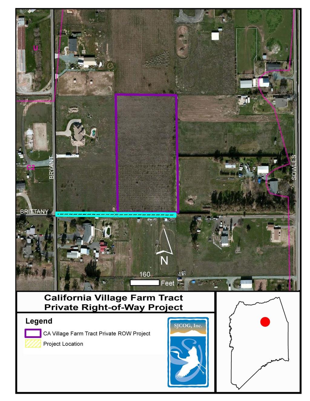
12 November 2016 HTAC STAFF REPORT SUBJECT: RECOMMENDED ACTION: California Village Farm Tract Private Right-of-Way Project Motion to Approve Recommendation to SJCOG, Inc. to Allow the California Village Farm Tract Private Right-of-Way Project to Participate in the SJMSCP DISCUSSION: SUMMARY: The project applicant, John Droge, is requesting coverage under the San Joaquin Multi-Species Habitat Conservation and Open Space Plan (SJMSCP) because the site is in an unmapped area of the plan. The project is located on the north side of E. Brittany Lane, 475 feet east of N. Bryant, northeast of Lodi in the Central Zone (attachment 1 and 2). RECOMMENDATION: SJCOG, Inc. staff recommends the HTAC make the recommendation to the SJCOG, Inc. Board to allow the project to participate under the SJMSCP to provide biological coverage for project impacts to the habitat types under the federal and state permits. FISCAL IMPACT: SJCOG, Inc. to be provided mitigation for the project impacts as required under the SJMSCP. If project participation is approved, SJCOG, Inc. will be provided mitigation for the project impacts as required under the SJMSCP for approximately 0.15 acres. The impacts for this project would consist of 0.15 acres of Multi-Purpose Open Space (C2) habitat at the appropriate rate of disturbance under the Plan. BACKGROUND: The project consists of a Site Approval application for a private right-of-way for lot 11 of the antiquated subdivision California Village Farm Tract Subdivision E (attachment 3). The SJMSCP GIS habitat layer classifies the project site as Multi-Purpose Open Space (C2).
13 If allowed to participate in the SJMSCP, the total disturbed area of 0.15 acres will consist of 0.15 acres of Multi-Purpose Open Space (C2) habitat impacts. The project applicant will be responsible for mitigating for the habitat impacts that is consumed by this project by either paying the appropriate fees at the time of ground disturbance or dedicating land in lieu of a fee at the appropriate SJMSCP ratio. Adjacent Vegetation and Land Use Location SJMSCP Vegetation Map Classification Habitat Type Category Actual Use Of Property Site Multi-Purpose Open Space (C2) Multi-Purpose Open Space (C2) Multi-Purpose Open Space (C2) North Multi-Purpose Open Space (C2) Multi-Purpose Open Space (C2) Multi-Purpose Open Space (C2) South Multi-Purpose Open Space (C2) Multi-Purpose Open Space (C2) Multi-Purpose Open Space (C2) Multi-Purpose Open Space (C2) and Multi-Purpose Open Space (C2) and Multi-Purpose Open Space (C2) East Urban (U) Urban (U) and Urban (U) West Multi-Purpose Open Space (C2) Multi-Purpose Open Space (C2) Multi-Purpose Open Space (C2) COMMITTEE ACTIONS: Habitat Technical Advisory Committee: Action Required SJCOG, Inc. Board: November 17 th if recommended ATTACHMENTS: 1. General Location Map 2. Project Location Map 3. Project Site Map Prepared by: Laurel Boyd, Assistant Habitat Planner

14 ATTACHMENT 1
15 ATTACHMENT 2
16 ATTACHMENT 3
17 November 2016 HTAC STAFF REPORT SUBJECT: RECOMMENDED ACTION: Whitaker Tract Private Right-of-Way Project Motion to Approve Recommendation to SJCOG, Inc. to 1) Allow the Whitaker Tract Private Right-of-Way Project to Participate in the SJMSCP; and 2) Allow a Revision to the Incidental Take Minimization Measures for Giant Garter Snake (GGS) and Western Pond Turtle (WPT) Buffers DISCUSSION: SUMMARY: The project applicant, Baumbach & Piazza, Inc., is requesting coverage under the San Joaquin Multi-Species Habitat Conservation and Open Space Plan (SJMSCP) because the site is in an unmapped area of the plan. The project is located 2,000 feet north of Turner Road, 4,000 feet east of Davis Road, northwest of Lodi, in the Central Zone (attachments 1 and 2). RECOMMENDATION: SJCOG, Inc. staff recommends the HTAC make the recommendation to the SJCOG, Inc. Board to 1) allow the project to participate under the SJMSCP to provide biological coverage for project impacts to the habitat types under the federal and state permits; and 2) allow a revision to the Incidental Take Minimizations Measures for Giant Garter Snake (GGS) and Western Pond Turtle (WPT) buffers. FISCAL IMPACT: SJCOG, Inc. to be provided mitigation for the project impacts as required under the SJMSCP. If project participation is approved, SJCOG, Inc. will be provided mitigation for the project impacts as required under the SJMSCP for approximately 1.17 acres. The impacts for this project would consist of 1.17 acres of Multi-Purpose Open Space (C2) habitat at the appropriate rate of disturbance under the Plan.
18 BACKGROUND: The project consists of a Site Approval application for a private right-of-way for a portion of lots 2 and 3 of the antiquated subdivision Whitaker Tract (attachment 3). In order for the project to construct a portion of the required work on the Whitaker Tract s Right-of-Way Project, the project will impact potential Giant Garter Snake (GGS) habitat within the suggested 200 foot buffer and Western Pond Turtle (WPT) within the 300 foot buffer. As identified in section 5.59 of the plan, HTAC, on a case by case review, can establish a setback and buffer zone to be used by a project in place of the 200 and 300 feet suggested. Because construction of portions of the project will be within the suggested 200 foot and 300 feet buffer areas, the project proponent has requested a reduction in the buffer to a 0 setback for the construction site impacts. The reduction of this buffer is necessary for the construction of this project. All other ITMM measures for GGS (e.g. construction window between May and October and required survey work) and WPT will remain standard. The SJMSCP GIS habitat layer classifies the project site as Multi-Purpose Open Space (C2). If allowed to participate in the SJMSCP, the total disturbed area of 1.17 acres will consist of 1.17 acres of Multi-Purpose Open Space (C2) habitat impacts. The project applicant will be responsible for mitigating for the habitat impacts that are consumed by this project by either paying the appropriate fees at the time of ground disturbance or dedicating land in lieu of a fee at the appropriate SJMSCP ratio. Adjacent Vegetation and Land Use Location SJMSCP Vegetation Map Classification Habitat Type Category Actual Use Of Property Site Multi-Purpose Open Space (C2) Multi-Purpose Open Space (C2) Multi-Purpose Open Space (C2) North Multi-Purpose Open Space (C2) Multi-Purpose Open Space (C2) Multi-Purpose Open Space (C2) South Multi-Purpose Open Space (C2) Multi-Purpose Open Space (C2) Multi-Purpose Open Space (C2) East Multi-Purpose Open Space (C2) Multi-Purpose Open Space (C2) Multi-Purpose Open Space (C2) West Multi-Purpose Open Space (C2) Multi-Purpose Open Space (C2) Multi-Purpose Open Space (C2) COMMITTEE ACTIONS: Habitat Technical Advisory Committee: Action Required SJCOG, Inc. Board: November 17 th if recommended ATTACHMENTS: 1. General Location Map 2. Project Location Map 3. Project Site Map Prepared by: Laurel Boyd, Assistant Habitat Planner

19 ATTACHMENT 1

20 ATTACHMENT 2
21 ATTACHMENT 3
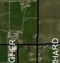
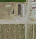
22 November 2016 HTAC STAFF REPORT SUBJECT: RECOMMENDED ACTION: River Road Warehouse Expansion Project Motion to Approve Recommendation to SJCOG, Inc. to 1) Allow an Alteration to the Habitat Type Coverage from Agricultural Habitat Land to Urban Habitat Land; and 2) Allow the River Road Warehouse Expansion Project to Participate in the SJMSCP DISCUSSION: SUMMARY: The project applicant, Norman Wilson, is requesting coverage under the San Joaquin Multi-Species Habitat Conservation and Open Space Plan (SJMSCP) because the site is in an unmapped area of the plan. The project is located on the south side of E. River Road, 2,300 feet east of Brennan Road, Escalon in the Central Zone (attachments 1 and 2). RECOMMENDATION: SJCOG, Inc. staff recommends the HTAC make the recommendation to the SJCOG, Inc. Board to 1) allow an alteration to the habitat type coverage; and 2) allow the project to participate under the SJMSCP to provide biological coverage for project impacts to the habitat types under the federal and state permits. FISCAL IMPACT: If the alteration to the habitat type is approved, SJCOG, Inc. will be provided mitigation for the project impacts as required under the SJMSCP for impacts to 1.07 acres of Agricultural (C34) and 4.10 acres of Urban (U) habitat at the appropriate rate of disturbance under the Plan. BACKGROUND: The project consists of a Site Approval application to expand a custom agricultural manufacturing facility in three phases over eight years. Phase 1 to include the construction of a 16,800 square foot sand blast and warehouse building. Phase 2, to be completed within 5 years, includes the construction of a 4,973 square foot warehouse building and an 8,660 square foot warehouse
23 building. Phase 3, to be completed within 8 years, to include the construction of two 8,000 square foot warehouse buildings (attachment 3). In accordance with the SJMSCP Planned Land Use Map, the project site is located in the unmapped land use area of the plan. Because it is not located on a SJMSCP Compensation Map, the project can request an alteration to the SJMSCP vegetation map habitat classification on a case by case review. The project is seeking an alteration to the habitat classification on the SJMSCP vegetation map based on the SJMSCP Section for a clerical change by the JPA to the habitat classification on the project site based on provided aerial photography imagery dated just prior to SJMSCP permit issuance in 2001 on a case-by-case review by the Habitat TAC for recommendation to the SJCOG, Inc. Board for approval. Based on the habitat classification by the permitting agencies and local jurisdictions prior to issuance of the SJMSCP permits in 2001 through broader review of habitat types in San Joaquin County, the SJMSCP GIS vegetation map habitat layer classifies the project site as Agricultural (C34). However; aerial photography (attachment 4) shows portions of the land within the project footprint is actual Urban (U) consisting of existing structures. The original SJMSCP habitat classification for this specific area would be re-classified from 4.10 acres of Agricultural (C34) habitat to 4.10 acres of Urban (U). If allowed to alter the SJMSCP vegetation map habitat classification under the SJMSCP, the total disturbed area of 5.17 acres will consist of 4.10 acres of Urban (U) and 1.07 acres of Agricultural (C34) habitat impacts. The project applicant will be responsible for mitigating for the habitat impacts caused by this project by either paying the appropriate fees at the time of ground disturbance or dedicating land in lieu of a fee at the appropriate SJMSCP ratio. Adjacent Vegetation and Land Use Location SJMSCP Vegetation Map Classification Habitat Type Category Actual Use Of Property Site Agriculture (C34) Agriculture (C34) Agriculture (C34) and Urban (U) North Multi-Purpose Open Space (C2) Multi-Purpose Open Space (C2) Multi-Purpose Open Space (U3) South Agriculture (C34) Agriculture (C34) Agriculture (C34) Agriculture (C34) and Natural (W6, G, Agriculture (C34) and Natural (W6, G, Agriculture (C34) and Natural East R2, R5) R2, R5) (W6, G, R2, R5) West Multi-Purpose Open Space (C2) Multi-Purpose Open Space (C2) Multi-Purpose Open Space (C2) COMMITTEE ACTIONS: Habitat Technical Advisory Committee: Action Required SJCOG, Inc. Board: November 17 th if Recommended
24 ATTACHMENTS: 1. General Location Map 2. Project Location Map 3. Project Site Map 4. Aerial Imagery Map Prior to 2001 Prepared by: Laurel Boyd, Assistant Habitat Planner

25 ATTACHMENT 1

26 ATTACHMENT 2
27 ATTACHMENT 3

28 ATTACHMENT 4
29 November 2016 HTAC STAFF REPORT SUBJECT: RECOMMENDED ACTION: Franzia Winery Expansion Project Motion to Approve Recommendation to SJCOG, Inc. to Allow the Franzia Winery Expansion Project to Participate in the SJMSCP DISCUSSION: SUMMARY: The project applicant, The Wine Group, is requesting coverage under the San Joaquin Multi-Species Habitat Conservation and Open Space Plan (SJMSCP) because the site is in an unmapped area of the plan. The project is located on the southeast corner of State Route 120 and Murphy Road, Ripon in the Central Zone (attachments 1 and 2). RECOMMENDATION: SJCOG, Inc. staff recommends the HTAC make the recommendation to the SJCOG, Inc. Board to allow the project to participate under the SJMSCP to provide biological coverage for the project impacts to the habitat types under the federal and state permits. FISCAL IMPACT: SJCOG, Inc. to be provided mitigation for the project impacts as required under the SJMSCP. If project participation is approved, SJCOG, Inc. will be provided mitigation for the project impacts as required under the SJMSCP for approximately 25.0 acres. The impacts for this project would consist of 25.0 acres of Multi-Purpose Open Space (C2) habitat at the appropriate rate of disturbance under the Plan. BACKGROUND: This project consists of a Use Permit application to expand an existing winery to include the construction of a 510,000 square foot warehouse for wine storage, a 6,000 square foot office, a 240 square foot scale house, 6 new rail cars, and a new truck scale. The SJMSCP GIS habitat layer classifies the project site as Multi-Purpose Open Space (C2).
30 If allowed to participate in the SJMSCP, the total disturbed area of 25.0 acres will consist of 25.0 acres of Multi-Purpose Open Space (C2) habitat impacts. The project applicant will be responsible for mitigating for the habitat impacts that is consumed by this project by either paying the appropriate fees at the time of ground disturbance or dedicating land in lieu of a fee at the appropriate SJMSCP ratio. Adjacent Vegetation and Land Use Location Site SJMSCP Vegetation Map Classification Multi-Purpose Open Space (C2), Urban (U) Habitat Type Category Multi-Purpose Open Space (C2), Urban (U) Actual Use Of Property Multi-Purpose Open Space (C2), Urban (U) North Agriculture (C34) Agriculture (C34) Multi-Purpose Open Space (C2) South Agriculture (C34) Agriculture (C34) Multi-Purpose Open Space (C2) East Agriculture (C34) Agriculture (C34) Multi-Purpose Open Space (C2) West Multi-Purpose Open Space (C2) Multi-Purpose Open Space (C2) Multi-Purpose Open Space (C2) COMMITTEE ACTIONS: Habitat Technical Advisory Committee: Action Required SJCOG, Inc. Board: November 17 th if recommended ATTACHMENTS: 1. General Location Map 2. Project Location Map 3. Project Site Map Prepared by: Laurel Boyd, Assistant Habitat Planner

31 ATTACHMENT 1

32 ATTACHMENT 2
33 ATTACHMENT 3
34 November 2016 HTAC STAFF REPORT SUBJECT: RECOMMENDED ACTION: Wilson Family Winery Project Motion to Approve Recommendation to SJCOG, Inc. to 1) Allow an Alteration to the Habitat Type Coverage from Agricultural Habitat Land to Urban Habitat Land; and 2) Allow the Wilson Family Winer Project to Participate in the SJMSCP DISCUSSION: SUMMARY: The project applicant, Krystal Allen, is requesting coverage under the San Joaquin Multi-Species Habitat Conservation and Open Space Plan (SJMSCP) because the site is in an unmapped area of the plan. The project is located on the south side of Harney Lane, 620 feet east of State Route 88, Lodi in the Central Zone (attachments 1 and 2). RECOMMENDATION: SJCOG, Inc. staff recommends the HTAC make the recommendation to the SJCOG, Inc. Board to 1) allow an alteration to the habitat type coverage; and 2) allow the project to participate under the SJMSCP to provide biological coverage for project impacts to the habitat types under the federal and state permits. FISCAL IMPACT: If the alteration to the habitat type is approved, SJCOG, Inc. will be provided mitigation for the project impacts as required under the SJMSCP for impacts to acres of Agricultural (C34) and 2.0 acres of Urban (U) habitat at the appropriate rate of disturbance under the Plan. BACKGROUND: The project site consists of a Site Approval application to establish a small winery to be constructed in two phases over five years. Phase one, to be completed in 18 months, includes the conversion of an existing 3,200 square foot agricultural storage building into a fermentation and barrel storage room and to utilize an existing 1,750 square foot concrete pad as a crush pad. Phase
35 two, to be completed in five years, is for the conversion of an existing 1,190 square foot residence into a wine tasting room. No marketing events are proposed with this application (attachment 3). In accordance with the SJMSCP Planned Land Use Map, the project site is located in the unmapped land use area of the plan. Because it is not located on a SJMSCP Compensation Map, the project can request an alteration to the SJMSCP vegetation map habitat classification on a case by case review. The project is seeking an alteration to the habitat classification on the SJMSCP vegetation map based on the SJMSCP Section for a clerical change by the JPA to the habitat classification on the project site based on provided aerial photography imagery dated just prior to SJMSCP permit issuance in 2001 on a case-by-case review by the Habitat TAC for recommendation to the SJCOG, Inc. Board for approval. Based on the habitat classification by the permitting agencies and local jurisdictions prior to issuance of the SJMSCP permits in 2001 through broader review of habitat types in San Joaquin County, the SJMSCP GIS vegetation map habitat layer classifies the project site as Agricultural (C34). However; aerial photography (attachment 4) shows portions of the land within the project footprint is actual Urban (U) consisting of existing structures. The original SJMSCP habitat classification for this specific area would be re-classified from acres of Agricultural (C34) habitat to 2.0 acres of Urban (U) habitat and the remainder acres to stay as Agricultural (C34) habitat. If allowed to alter the SJMSCP vegetation map habitat classification under the SJMSCP, the total disturbed area of acres will consist of 2.0 acres of Urban (U) and acres of Agricultural (C34) habitat impacts. The project applicant will be responsible for mitigating for the habitat impacts caused by this project by either paying the appropriate fees at the time of ground disturbance or dedicating land in lieu of a fee at the appropriate SJMSCP ratio. Adjacent Vegetation and Land Use Location SJMSCP Vegetation Map Habitat Type Category Actual Use Of Property Classification Site Agriculture (C34) Agriculture (C34) Urban (U) North Agriculture (C34) Agriculture (C34) Agriculture (C34) South Agriculture (C34) Agriculture (C34) Agriculture (C34) East Agriculture (C34) Agriculture (C34) Agriculture (C34) West Agriculture (C34) Agriculture (C34) Agriculture (C34) and Urban (U) COMMITTEE ACTIONS: Habitat Technical Advisory Committee: Action Required SJCOG, Inc. Board: November 17 th if Recommended
36 ATTACHMENTS: 1. General Location Map 2. Project Location Map 3. Project Site Map 4. Aerial Imagery Map Prior to 2001 Prepared by: Laurel Boyd, Assistant Habitat Planner


37 ATTACHMENT 1


38 ATTACHMENT 2


39 ATTACHMENT 3


40 ATTACHMENT 4
Attachments: Negative Declaration Initial Study (CEQA 15073(c))
)") NOTICE OF AVAILABILITY AND INTENT TO ADOPT AN INITIAL STUDY/NEGATIVE DECLARATION DUTRA ESTATES UNIT 5 GENERAL PLAN AMENDMENT, REZONE, TENTATIVE SUBDIVISION MAP, PLANNED DEVELOPMENT AMENDMENT, & DEVELOPMENT
NOTICE OF AVAILABILITY AND INTENT TO ADOPT AN INITIAL STUDY/NEGATIVE DECLARATION DUTRA ESTATES UNIT 5 GENERAL PLAN AMENDMENT, REZONE, TENTATIVE SUBDIVISION MAP, PLANNED DEVELOPMENT AMENDMENT, & DEVELOPMENT
Napa County Planning Commission Board Agenda Letter
 Agenda Date: 7/20/2011 Agenda Placement: 10A Napa County Planning Commission Board Agenda Letter TO: FROM: Napa County Planning Commission Hillary Gitelman - Director Conservation, Development & Planning
Westover Metropolitan Airport Master Plan Update
 Westover Metropolitan Airport Master Plan Update June 2008 INTRODUCTION Westover Metropolitan Airport (CEF) comprises the civilian portion of a joint-use facility located in Chicopee, Massachusetts. The
ACTION TRANSMITTAL
 Transportation Advisory Board of the Metropolitan Council of the Twin Cities ACTION TRANSMITTAL 2018-16 DATE: February 9, 2018 TO: Transportation Advisory Board FROM: Technical Advisory Committee PREPARED
Spadina Avenue Built Form Study Preliminary Report
 STAFF REPORT ACTION REQUIRED Spadina Avenue Built Form Study Preliminary Report Date: July 9, 2014 To: From: Wards: Reference Number: Toronto and East York Community Council Director, Community Planning,
METROPOLITAN COUNCIL 390 North Robert Street, St. Paul, MN Phone (651) TDD (651)
 TDD (651)") DATE: March 27, 2012 METROPOLITAN COUNCIL 390 North Robert Street, St. Paul, MN 55101 Phone (651) 602-1000 TDD (651) 291-0904 TO: Metropolitan Parks and Open Space Commission FROM: Arne Stefferud, Planning
DATE: March 27, 2012 METROPOLITAN COUNCIL 390 North Robert Street, St. Paul, MN 55101 Phone (651) 602-1000 TDD (651) 291-0904 TO: Metropolitan Parks and Open Space Commission FROM: Arne Stefferud, Planning
SAMTRANS TITLE VI STANDARDS AND POLICIES
 SAMTRANS TITLE VI STANDARDS AND POLICIES Adopted March 13, 2013 Federal Title VI requirements of the Civil Rights Act of 1964 were recently updated by the Federal Transit Administration (FTA) and now require
Lake Tahoe Airport Master Plan
 Lake Tahoe Airport Master Plan City Council Briefing October 20, 2015 What is an Airport Master Plan? a comprehensive study of an airport [that] usually describes the short, medium, and long term development
Susitna-Watana Hydroelectric Project (FERC No ) Recreation Resources Study Study Plan Section Study Implementation Report
 Recreation Resources Study Study Plan Section Study Implementation Report") (FERC No. 14241) Recreation Resources Study Study Plan Section 12.5 2014 Study Implementation Report Prepared for Prepared by AECOM November 2015 TABLE OF CONTENTS 1. Introduction... 4 2. Study Objectives...
(FERC No. 14241) Recreation Resources Study Study Plan Section 12.5 2014 Study Implementation Report Prepared for Prepared by AECOM November 2015 TABLE OF CONTENTS 1. Introduction... 4 2. Study Objectives...
DRAFT GENERAL IMPLEMENTATION PLAN AND SPECIFIC IMPLEMENTATION PLAN MIDDLETON MUNICIPAL AIRPORT MOREY FIELD. Revised 12/12/03
 DRAFT GENERAL IMPLEMENTATION PLAN AND SPECIFIC IMPLEMENTATION PLAN MIDDLETON MUNICIPAL AIRPORT MOREY FIELD Revised 12/12/03 As recommended for approval by the Plan Commission General Project Description
CITY COUNCIL AGENDA MEMORANDUM
 To: Mayor and City Council From: Charles Ozaki, City and County Manager Prepared By: Kevin Standbridge, Deputy City and County Manager Katie Allen, City and County Engineer David Shinneman, Community Development
DRAFT FINAL REPORT AIRPORT MASTER PLAN. Rifle Garfield County Airport Revised May 15, 2014
 DRAFT FINAL REPORT AIRPORT MASTER PLAN Rifle Garfield County Airport Revised May 15, 2014 As required by Paragraph 425.B(4) of FAA Order 5100.38C, Airport Improvement Program (AIP) Handbook: The preparation
Decision Memo Broken Wheel Ranch Equestrian Outfitter Special-Use Permit Proposed Action
 Decision Memo Broken Wheel Ranch Equestrian Outfitter Special-Use Permit USDA Forest Service Mississippi Bluffs Ranger District, Shawnee National Forest Jackson and Union Counties, Illinois Proposed Action
Lake Tahoe Airport Master Plan Public Meeting March 16, 2015
 Lake Tahoe Airport Master Plan Public Meeting March 16, 2015 What is an Airport Master Plan? a comprehensive study of an airport [that] usually describes the short, medium, and long term development plans
SAN MATEO COUNTY AGRITOURISM GUIDELINES
 SAN MATEO COUNTY AGRITOURISM GUIDELINES The San Mateo County Planning and Building Department and the San Mateo County Agricultural Advisory Committee s subcommittee on agritourism have developed the following
TRANSPORTATION ADVISORY BOARD. Metropolitan Council, 390 Robert Street North, Saint Paul, Minnesota 55101
 TRANSPORTATION ADVISORY BOARD 1) Call to Order 2) Adoption of Agenda Metropolitan Council, 390 Robert Street North, Saint Paul, Minnesota 55101 NOTICE OF A MEETING of the PLANNING COMMITTEE Thursday, June
Report on Installation of Wayside Horns at Railroad Crossings and Railroad Trench System
 City Council Agenda November 4, 2014 Mayor and Council Agenda Item No. B.01 Reviewed by City Mgr s office: /KLM Memo to: From: Manteca City Council Karen L. McLaughlin, City Manager Date: October 28, 2014
ROUTE ANALYSIS PROCESS
 ROUTE ANALYSIS PROCESS Progress to Date: 1. Recorded and labeled all routes received from PAT Meetings. 2. Determined opportunity, avoidance and exclusion areas crossed by PAT proposed routes. 3. Routes
NAVAJO COMMUNITY PLAN
 NAVAJO COMMUNITY PLAN Prepared by the NAVAJO COMMUNITY PLANNERS and THE CITY OF SAN DIEGO City of San Diego Planning Department 202 C Street, MS 4A San Diego, CA 92101 Printed on recycled paper. This information,
Board of Adjustment AGENDA. April 25, :00 P.M. City Council Chambers
 MAYOR Hal J. Rose DEPUTY MAYOR John Coach Tice COUNCIL MEMBERS Pat Bentley Stephany Eley Bill Mettrick Andrea Young Barbara Smith Planning & Economic Development Dept. Christy Fischer, Planning Director
Welcome to Public Information Workshop 1. San Francisco International Airport FAR Part 150 Study Update Noise Exposure Map Report
 Welcome to Public Information Workshop 1 Chetcuti Room, City of Milbrae 450 Poplar Avenue Milbrae, California 94030 Wednesday, June 4, 2014 5:45 p.m. to 6:45 p.m. PDT The FAA typically uses the airport
Mather Restoration Advisory Board (RAB) Meeting Draft Summary Meeting Minutes. Mather, California. 11 March 2009
 Meeting Draft Summary Meeting Minutes. Mather, California. 11 March 2009") Mather Restoration Advisory Board (RAB) Meeting Draft Summary Meeting Minutes 11 March 2009 Time: Place: 6:00 PM Air Force Real Property Agency (AFRPA) Conference Room 10503 Armstrong Avenue Mather, CA
Mather Restoration Advisory Board (RAB) Meeting Draft Summary Meeting Minutes 11 March 2009 Time: Place: 6:00 PM Air Force Real Property Agency (AFRPA) Conference Room 10503 Armstrong Avenue Mather, CA
MONTEREY REGIONAL AIRPORT MASTER PLAN TOPICAL QUESTIONS FROM THE PLANNING ADVISORY COMMITTEE AND TOPICAL RESPONSES
 MONTEREY REGIONAL AIRPORT MASTER PLAN TOPICAL QUESTIONS FROM THE PLANNING ADVISORY COMMITTEE AND TOPICAL RESPONSES Recurring topics emerged in some of the comments and questions raised by members of the
AGENDA GUEMES ISLAND FERRY OPERATIONS PUBLIC FORUM
 AGENDA GUEMES ISLAND FERRY OPERATIONS PUBLIC FORUM Wednesday, August 17, 211 6: p.m. Guemes Island Community Hall ~ 7549 Guemes Island Road Thank you for attending the second Annual Public Forum in 211.
Establishes a fare structure for Tacoma Link light rail, to be implemented in September 2014.
 RESOLUTION NO. R2013-24 Establish a Fare Structure and Fare Level for Tacoma Link MEETING: DATE: TYPE OF ACTION: STAFF CONTACT: PHONE: Board 09/26/2013 Final Action Ric Ilgenfritz, Executive Director,
2. Goals and Policies. The following are the adopted Parks and Trails Goals for Stillwater Township:
 D. PARKS AND TRAILS 1. Introduction Stillwater Township s population is relatively low, with most residents living on rural residences on large lots. The need for active park space has been minimal in
STAFF REPORT. Airport Land Use Plan Consistency Review: Old Town Village Mixed Use Project City of Goleta. MEETING DATE: June 18, 2015 AGENDA ITEM: 5M
 STAFF REPORT SUBJECT: Airport Land Use Plan Consistency Review: Old Town Village Mixed Use Project City of Goleta MEETING DATE: AGENDA ITEM: 5M STAFF CONTACT: Peter Imhof, Andrew Orfila RECOMMENDATION:
SPECIAL MEETING PACKET
 County of San Mateo Planning & Building Department Agricultural Advisory Committee 455 County Center, 2 nd Floor Redwood City, California 94063 650/363-4161 Fax: 650/363-4849 SPECIAL MEETING PACKET Date:
Classifications, Inventory and Level of Service
 Classifications, Inventory and Level of Service Section 3 Kenmore Park, Recreation and Open Space Plan 1 P a g e Classifications and Inventory Park Classifications Kenmore classifies its parks based upon
REGIONAL BOARD REPORT
 REGIONAL BOARD REPORT Administrator s Office For the Board August 21, 2008 DATE: August 14, 2008 FILE NOS.: A-07-06377/8/9.000 FROM: RE: Chief Administrative Officer OCP and Zoning Amendment Application
WELCOME TO YOUR REGIONAL AIRPORT AUTHORITY MEETING OF THE CITY OF MERCED AGENDA
 WELCOME TO YOUR REGIONAL AIRPORT AUTHORITY MEETING OF THE CITY OF MERCED AUTHORITY MEMBERS Larry Morelock-Chair, Alvin Osborn-Vice-Chair, John Sundgren, Rodrigo Flores, Ryan Smith, and Michael Bodine.
COASTAL CONSERVANCY. Staff Recommendation September 22, 2011 BAY AREA RIDGE TRAIL: HOOD MOUNTAIN TO HIGHWAY 12
 COASTAL CONSERVANCY Staff Recommendation September 22, 2011 BAY AREA RIDGE TRAIL: HOOD MOUNTAIN TO HIGHWAY 12 File No. 11-039-001 Project Manager: Betsy Wilson RECOMMENDED ACTION: Authorization to disburse
DATE: January 19, WCA Governing Board. Johnathan Perisho, Project Manager. Mark Stanley, Executive Officer
 Item 14 DATE: January 19, 2017 TO: FROM: THROUGH: SUBJECT: WCA Governing Board Johnathan Perisho, Project Manager Mark Stanley, Executive Officer Item 14: Consideration of a resolution to accept an acquisition
Social Services Transportation Advisory Council (SSTAC)
") 210 N. Church Street, Suite B Visalia, California 93291 (559) 623-0450 FAX (559) 733-6720 www.tularecog.org Social Services Transportation Advisory Council (SSTAC) MEETING AGENDA Tuesday, November 18,
210 N. Church Street, Suite B Visalia, California 93291 (559) 623-0450 FAX (559) 733-6720 www.tularecog.org Social Services Transportation Advisory Council (SSTAC) MEETING AGENDA Tuesday, November 18,
CITY OF SPOKANE VALLEY Request for Council Action
 CITY OF SPOKANE VALLEY Request for Council Action Meeting Date: June 28, 2016 Department Director Approval: Item: Check all that apply: consent old business new business public hearing information admin.
Executive Directors Report
 SAN DIEGUITO RIVER PARK JOINT POWERS AUTHORITY 9:30 a.m. 12:00 p.m. Friday, July 18, 2014 County Administration Center 1600 Pacific Highway, Room 302/303 San Diego Speaker slips will be available. Please
Sawtooth National Forest Fairfield Ranger District
 United States Department of Agriculture Forest Service Sawtooth National Forest Fairfield Ranger District P.O. Box 189 Fairfield, ID. 83327 208-764-3202 Fax: 208-764-3211 File Code: 1950/7700 Date: December
Hutchinson Regional Airport Request for Proposals for Hangar Lease RFP #15-163
 Hutchinson Regional Airport Request for Proposals for Hangar Lease RFP #15-163 INTRODUCTION The City of Hutchinson is issuing a Request For Proposal (RFP) for the private or commercial use of the Hangar
CITY OF APPLE VALLEY PLANNING COMMISSION MINUTES JULY 19, 2017
 PLANNING COMMISSION MINUTES JULY 19, 2017 1. CALL TO ORDER The City of Apple Valley Planning Commission meeting was called to order by Chair Melander at 7:00 p.m. Members Present: Tom Melander, Ken Alwin,
Rule Governing the Designation and Establishment of All-Terrain Vehicle Use Trails on State Land
 Rule Governing the Designation and Establishment of All-Terrain Vehicle Use Trails on State Land 1.0 Authority 1.1 This rule is promulgated pursuant to 23 V.S.A. 3506. Section 3506 (b)(4) states that an
Daisy Dean Trail 628/619 ATV Trail Construction
 Background and Purpose and Need The Daisy Dean ATV Trail Construction Project is located in the Little Belt Mountains, Musselshell Ranger District, Lewis and Clark National Forest approximately 32 miles
AGENDA. WEDNESDAY, SEPTEMBER 23, :00 PM or immediately after the ICTC meeting
 AGENDA WEDNESDAY, SEPTEMBER 23, 2015 6:00 PM or immediately after the ICTC meeting County Administration Building, 2 nd Floor Board of Supervisors Chambers 940 W. Main St. El Centro, CA 92243 CHAIRPERSON:
STAFF REPORT. Airport Land Use Consistency Determination Betteravia Plaza. MEETING DATE: January 21, 2016 AGENDA ITEM: 8D
 STAFF REPORT SUBJECT: Airport Land Use Consistency Determination Betteravia Plaza MEETING DATE: AGENDA ITEM: 8D STAFF CONTACT: Andrew Orfila RECOMMENDATION: Adopt findings for the Betteravia Plaza project
The Corporation of the City of Kawartha Lakes Council Report
 The Corporation of the City of Kawartha Lakes Council Report Report Number ENG2017-008 Date: September 12, 2017 Time: 2:00 p.m. Place: Council Chambers Ward Community Identifier: All Subject: Author Name
2015 PURDUE ROAD SCHOOL March 11, 2015
 2015 PURDUE ROAD SCHOOL March 11, 2015 Runway Protection Zone (RPZ) Definition It is a trapezoidal shape formed off the end of a runway and its geometry it a function of the airport s aircraft approach
TOWNSHIP OF LOWER MERION. PUBLIC WORKS COMMITTEE Wednesday, October 4, :10 PM ( Approximately)
") TOWNSHIP OF LOWER MERION PUBLIC WORKS COMMITTEE Wednesday, October 4, 2017 7:10 PM ( Approximately) Chairpersons: Vice Chairperson: Paul A. McElhaney Cheryl B. Gelber, C. Brian McGuire AGENDA 1. REALIGNMENT
TOWNSHIP OF LOWER MERION PUBLIC WORKS COMMITTEE Wednesday, October 4, 2017 7:10 PM ( Approximately) Chairpersons: Vice Chairperson: Paul A. McElhaney Cheryl B. Gelber, C. Brian McGuire AGENDA 1. REALIGNMENT
CHAPTER 6 NOISE EXPOSURE
 CHAPTER 6 NOISE EXPOSURE FAA requires that the NEM submitted for review represent the aircraft noise exposure for the year of submittal (in this case 2008) and for a future year (2013 for OSUA). However,
AGENDA Addendum 1 Special Meeting of the Board of City Commissioners June 6, :30 pm City Hall Williston, North Dakota
 AGENDA Addendum 1 Special Meeting of the Board of City Commissioners June 6, 2018-3:30 pm City Hall Williston, North Dakota 1. Roll Call of Commissioners 2. Farm Plan Group 1 Bid Award 3. Farm Plan Group
Mark Kazmierczak, Chair ANC 6C Transportation and Public Space Committee By
 P. O. Box 15264 Washington DC 20003-0264 202-543-0425 www.chrs.org; caphrs@aol.com February 24, 2016 Mark Kazmierczak, Chair ANC 6C Transportation and Public Space Committee By email: Mark.kaz.anc@gmail.com
AIRPORT MASTER PLAN. Newport State Airport. Draft. (Colonel Robert F. Wood Airpark) THE Louis Berger Group, INC. Prepared for: Prepared by:
 THE Louis Berger Group, INC. Prepared for: Prepared by:") Draft AIRPORT MASTER PLAN Newport State Airport () Prepared for: 2000 Post Road Warwick, Rhode Island 02886-1533 THE Louis Berger Group, INC. 20 Corporate Woods Boulevard Albany, New York 12211-2370 Prepared
Draft AIRPORT MASTER PLAN Newport State Airport () Prepared for: 2000 Post Road Warwick, Rhode Island 02886-1533 THE Louis Berger Group, INC. 20 Corporate Woods Boulevard Albany, New York 12211-2370 Prepared
COASTAL CONSERVANCY. Staff Recommendation December 2, 2004 COYOTE HELLYER COUNTY PARK BAY AREA RIDGE TRAIL
 COASTAL CONSERVANCY Staff Recommendation December 2, 2004 COYOTE HELLYER COUNTY PARK BAY AREA RIDGE TRAIL File No. 04-057 Project Manager: Amy Hutzel RECOMMENDED ACTION: Authorization to disburse up to
Parkland County Municipal Development Plan Amendment Acheson Industrial Area Structure Plan
 Parkland County Municipal Development Plan Amendment Acheson Industrial Area Structure Plan New Plan Acheson Industrial Area Structure Plan Amendment Parkland County Municipal Development Plan Board Reference
Industrial Investment Property
 Industrial Investment Property Fully Leased NNN Investment 2945-2965 SOUTH ANG AVENUE - FRESNO, CALIFORNIA BUILDING FEATURES 24-27 CEILING HEIGHT 60 X 28 COLUMN SPACING CONCRETE TILT-UP CONSTRUCTION FULLY
CHAPTER 1 EXECUTIVE SUMMARY
 CHAPTER 1 EXECUTIVE SUMMARY 1 1 EXECUTIVE SUMMARY INTRODUCTION William R. Fairchild International Airport (CLM) is located approximately three miles west of the city of Port Angeles, Washington. The airport
Summary of Committee Discussion/Questions Metropolitan Transportation Services Senior Planner Russ Owen presented this item.
 Committee Report Business Item No. 2017-191 Transportation Committee For the Metropolitan Council meeting of September 13, 2017 Subject: Final Crystal Airport 2035 Long Term Comprehensive Plan (LTCP) Proposed
City of College Park s Update to the Zoning Ordinance
 Comparison table for the City s Zoning Ordinance Residential s R-1 Single Family R-2 Single Family Single family uses 24,000 sq ft lot size 90 ft lot width Front 60 ft Side 15 ft Rear 40 ft Minimum floor
Proposed Action. Payette National Forest Over-Snow Grooming in Valley, Adams and Idaho Counties. United States Department of Agriculture
 United States Department of Agriculture Forest Service January 2012 Proposed Action Payette National Forest Over-Snow Grooming in Valley, Adams and Idaho Counties Payette National Forest Valley, Adams
WEKIVA WILD AND SCENIC RIVER ACT OF 2000
 PUBLIC LAW 106 299 OCT. 13, 2000 WEKIVA WILD AND SCENIC RIVER ACT OF 2000 VerDate 11-MAY-2000 01:59 Oct 20, 2000 Jkt 069139 PO 00000 Frm 00001 Fmt 6579 Sfmt 6579 E:\PUBLAW\PUBL299.106 APPS27 PsN: PUBL299
Mountain Valley Pipeline, LLC Mountain Valley Pipeline Project Docket No. CP
 16. Prior to construction, Mountain Valley shall file with the Secretary, for review and approval by the Director of OEP, a segment-specific construction and operation access plan for the area between
Unmanned Aircraft System (Drone) Policy
 Policy") Unmanned Aircraft System (Drone) Policy Responsible Officer: Chief Risk Officer Responsible Office: RK - Risk / EH&S Issuance Date: TBD Effective Date: TBD Last Review Date: New Policy Scope: Includes
Unmanned Aircraft System (Drone) Policy Responsible Officer: Chief Risk Officer Responsible Office: RK - Risk / EH&S Issuance Date: TBD Effective Date: TBD Last Review Date: New Policy Scope: Includes
MESA COUNTY DEPARTMENT OF PUBLIC WORKS Administration - Building - Engineering Road and Bridge Traffic - Planning - Solid Waste Management
 MESA COUNTY DEPARTMENT OF PUBLIC WORKS Administration - Building - Engineering Road and Bridge Traffic - Planning - Solid Waste Management 200 S. Spruce St. P.O. Box 20,000 Grand Junction, Colorado 81502-5022
City of Durango 5.8 FUNDING TRAILS DEVELOPMENT
 5.8 FUNDING TRAILS DEVELOPMENT The City has been successful in establishing dedicated local funding sources as well as applying for grants to develop the City s trail system, having received nearly $2.4
Community Development
 Community Development City & Borough of Juneau Community Development 155 S. Seward Street Juneau, AK 99801 (907) 586 0715 Phone (907) 586 4529 Fax DATE: February 11, 2016 TO: FROM: Planning Commission
SAN FRANCISCO MUNICIPAL TRANSPORTATION AGENCY
 THIS PRINT COVERS CALENDAR ITEM NO. : 10.2 DIVISION: Sustainable Streets BRIEF DESCRIPTION: SAN FRANCISCO MUNICIPAL TRANSPORTATION AGENCY Amending Transportation Code, Division II to prohibit parking on
1 PLANNING BOARD COUNTY OF ALBANY
 1 PLANNING BOARD COUNTY OF ALBANY 1 2 TOWN OF COLONIE 3 ***************************************************** CORE MATERIALS 4 113 KARNER ROAD SKETCH PLAN 5 *****************************************************
Region of Waterloo Planning, Development and Legislative Services Region of Waterloo International Airport Office of Economic Development
 Region of Waterloo Planning, Development and Legislative Services Region of Waterloo International Airport Office of Economic Development To: Chair Tom Galloway and Members of the Planning and Works Committee
Airport Master Plan Open House Front Range Airport February 23, 2017
 Airport Master Plan Open House Front Range Airport February 23, 2017 MASTER PLAN PROCESS AND OVERVIEW MASTER PLAN ELEMENTS The Master Plan is a 20-year plan to understand the needs of current and future
Alternative 3 Prohibit Road Construction, Reconstruction, and Timber Harvest Except for Stewardship Purposes B Within Inventoried Roadless Areas
 Roadless Area Conservation FEIS Summary Table S-1. Comparison of Key Characteristics and Effects by Prohibition Alternative. The effects summarized in this table A would occur in inventoried roadless areas
CITY OF PALMDALE. REPORT to the Mayor and Members of the City Council from the City Manager
 CITY OF PALMDALE REPORT to the Mayor and Members of the City Council from the City Manager DATE: June 4, 2014 SUBJECT: Specific Plan Amendment 14-01; Amending the Use Designation of 23.97 Acres within
Redtail Ranch Preliminary Plan and Filing No. 1 Final Plat, Review #2 (SP , SF )
") COMMISSINERS: DARRYL GLENN (PRESIDENT) MARK WALLER (PRESIDENT PRO TEMPORE) PEGGY LITTLETON LONGINOS GONZALEZ, JR. STAN VANDERWERF COMMUNITY SERVICES DEPARTMENT PARK OPERATIONS ~ PLANNING ~ CSU EXTENSION
COMMISSINERS: DARRYL GLENN (PRESIDENT) MARK WALLER (PRESIDENT PRO TEMPORE) PEGGY LITTLETON LONGINOS GONZALEZ, JR. STAN VANDERWERF COMMUNITY SERVICES DEPARTMENT PARK OPERATIONS ~ PLANNING ~ CSU EXTENSION
MINUTES OF THE OAK CREEK PLAN COMMISSION MEETING TUESDAY, NOVEMBER 8, 2011
 MINUTES OF THE OAK CREEK PLAN COMMISSION MEETING TUESDAY, NOVEMBER 8, 2011 Mayor Bolender called the meeting to order at 7:00 p.m. The following Commissioners were present at roll call: Commissioner Dickmann,
Madison Metro Transit System
 Madison Metro Transit System 1101 East Washington Avenue Madison, Wisconsin, 53703 Administrative Office: 608 266 4904 Fax: 608 267 8778 TO: FROM: SUBJECT: Plan Commission Timothy Sobota, Transit Planner,
Agenda East County Board of Zoning Adjustments Thursday, July 17, 2008
 The meeting room is wheelchair accessible. A Sign Language interpreter may be available upon five (5) days notice. Please telephone 510-670-5400. Personal sound amplifiers are available for the hearing
County of Riverside - PSEC Project General Habitat Assessment Appendix A
 County of Riverside - PSEC Project General Habitat Assessment Appendix A Lake Elsinore Lake Elsinore The Lake Elsinore study area is located in the hills directly adjacent to Lake Elsinore, in the City
PORT OF SEATTLE MEMORANDUM. COMMISSION AGENDA Item No. 4g ACTION ITEM Date of Meeting February 9, 2016
 PORT OF SEATTLE MEMORANDUM COMMISSION AGENDA Item No. 4g ACTION ITEM Date of Meeting February 9, 2016 DATE: TO: FROM: Michael Ehl, Director, Airport Operations Wayne Grotheer, Director, Aviation Project
Executive Summary Downtown Park Fund Allocation HEARING DATE: MAY 5, 2016
 Executive Summary Downtown Park Fund Allocation HEARING DATE: MAY 5, 2016 Date: April 28, 2016 Case No.: 2016 004634CWP Project Name: Allocation of $4,000,000 from the Downtown Park Fund for the Renovation
Vista Field Airport. Master Plan Update. February, Prepared for: Port of Kennewick One Clover Island Kennewick, Washington
 Vista Field Airport February, 2006 Prepared for: Port of Kennewick One Clover Island Kennewick, Washington 99336 Prepared by: J-U-B ENGINEERS, Inc. 2810 W. Clearwater Avenue, Suite 201 Kennewick, Washington
CONSERVATION COMMISSION MEETING Thursday, July 19, :00 PM City Hall, Council Chambers, Claremont, NH. MINUTES Approved 8/16/2018
 CONSERVATION COMMISSION MEETING Thursday, July 19, 2018 6:00 PM City Hall, Council Chambers, Claremont, NH MINUTES Approved 8/16/2018 Mr. Dickerman called the meeting to order at 6:03 PM and asked for
2016 Regional Transportation Alternatives Program (TAP) Grant Application
 Grant Application") 2016 Regional Transportation Alternatives Program (TAP) Grant Application PROJECT TITLE: Yelm-Tenino Trail Extension Feasibility Study TRPC use only GENERAL PROJECT INFORMATION Agency or Organization City
2016 Regional Transportation Alternatives Program (TAP) Grant Application PROJECT TITLE: Yelm-Tenino Trail Extension Feasibility Study TRPC use only GENERAL PROJECT INFORMATION Agency or Organization City
CHAPTER III: TRAIL DESIGN STANDARDS, SPECIFICATIONS & PERMITS
 CHAPTER III Trail Design Standards, Specifications & Permits This chapter discusses trail standards, preferred surface types for different activities, permits, and other requirements one must consider
PLANNING BOARD MEETING Monday, November 13, :00 PM Council Chambers, City Hall. MINUTES Approved 12/11/2017
 PLANNING BOARD MEETING Monday, November 13, 2017 7:00 PM Council Chambers, City Hall MINUTES Approved 12/11/2017 I. Roll Call Present: Marilyn Harris, Bruce Kolenda, Marlene Jordan, Richard Wahrlich, David
Community Development Department Council Chambers, 7:30 PM, December 20, 2012
 STAFF REPORT 2012-56P: Alley Vacation Community Development Department Council Chambers, 7:30 PM, December 20, 2012 To: From: Re: Paul Luke, Chairman, Skokie Plan Commission Mike Voitik, Planning Technician
General Aviation Master Plan Update
 Peter O. Knight Airport Public Meeting #2 Peter O. Knight Airport Agenda Welcome and Introductions HCAA System of Airports Purpose of Public Meetings Master Plan Status Update Next Steps Q & A 2 Our System
Norfolk International Airport
 Norfolk International Airport Master Plan Update Technical Advisory Committee Meeting #1 Community Advisory Committee Meeting #1 January 24, 2018 Agenda Project Background Introductions Overview of Airport
Commission SUMMARY: 12, Action. review. hearing is. being. 601 E Kennedy Blvd., 18
 Hillsborough County City-Countyy Planning Commission 601 E Kennedy Blvd., 18 th floor, Tampa, Florida, 33601 813-272-5940 theplanningcommission.org EXECUTIVE SUMMARY Meeting Date: August 12, 2013 Agenda
AGENDA ITEM 5 D WAKULLA ENVIRONMENTAL INSTITUTE (WEI) TRAIL FEASIBILITY STUDY
 TRAIL FEASIBILITY STUDY") March 19, 2018 AGENDA ITEM 5 D WAKULLA ENVIRONMENTAL INSTITUTE (WEI) TRAIL FEASIBILITY STUDY TYPE OF ITEM: Action STATEMENT OF ISSUE The Wakulla Environmental Institute (WEI) Trail is one of several trails
March 19, 2018 AGENDA ITEM 5 D WAKULLA ENVIRONMENTAL INSTITUTE (WEI) TRAIL FEASIBILITY STUDY TYPE OF ITEM: Action STATEMENT OF ISSUE The Wakulla Environmental Institute (WEI) Trail is one of several trails
Mason County Planning & Zoning Department 102 E. FIFTH STREET SCOTTVILLE, MICHIGAN (231) FAX (231)
 FAX (231)") Mason County Planning & Zoning Department E. FIFTH STREET SCOTTVILLE, MICHIGAN (1) - FAX (1) - 1 1 1 1 1 0 1 0 1 0 1 November, 0 Minutes of the Mason County Planning Commission meeting held at E. Fifth
Mason County Planning & Zoning Department E. FIFTH STREET SCOTTVILLE, MICHIGAN (1) - FAX (1) - 1 1 1 1 1 0 1 0 1 0 1 November, 0 Minutes of the Mason County Planning Commission meeting held at E. Fifth
Lathrop Industrial Complex
 A Project by: AVAILABLE FOR SALE OR LEASE three overhead cranes heavy power yard/trailer parking rail served EXCLUSIVE BROKERS - INDUSTRIAL SERVICES TEAM: MIKE GOLDSTEIN, SIOR Executive Managing Director
Disposition of Spadina Expressway Properties - Memorandum of Understanding with Infrastructure Ontario
 GM22.32 REPORT FOR ACTION Disposition of Spadina Expressway Properties - Memorandum of Understanding with Infrastructure Ontario Date: September 8, 2017 To: Government Management Committee From: Chief
MASTER PLAN EXECUTIVE SUMMARY
 Biscuit Run State Park Scottsville Road (State Route 20) Charlottesville, VA 22902 Biscuit Run State Park MASTER PLAN EXECUTIVE SUMMARY Department of Conservation and Recreation Division of Planning and
METROBUS SERVICE GUIDELINES
 METROBUS SERVICE GUIDELINES In the late 1990's when stabilization of bus service was accomplished between WMATA and the local jurisdictional bus systems, the need for service planning processes and procedures
Union Station Rail Corridor East Enhancements Project
 Union Station Rail Corridor East Enhancements Project Transit Project Assessment Process Public Meeting #1 Presentation Wednesday June 28, 2017 GRIDLOCK COSTS OUR ECONONY REGIONAL TRANSFORMATION GO EXPANSION
City of Surrey PLANNING & DEVELOPMENT REPORT File:
 City of Surrey PLANNING & DEVELOPMENT REPORT File: 7917-0297-00 Planning Report Date: September 11, 2017 PROPOSAL: Amend CD By-law No. 18795 (based on RH-G). to allow for an increased house size on thirteen
Proposed Official Plan Amendment 41 to the Region of York Official Plan
 COMMITTEE OF THE WHOLE NOVEMBER 18, 2002 REGION OF YORK OFFICIAL PLAN AMENDMENT 41 THE OAK RIDGES MORAINE CONSERVATION PLAN Recommendation The Commissioner of Planning recommends: 1. That the City of Vaughan
I. Call to Order. A. Invocation. B. Pledge of Allegiance. Employee Awards. Public Information Update. 1. PIO Update- Page: 6
 Agenda Okaloosa County Board of Commissioners Tuesday, April 16, 2019 8:30 AM Okaloosa County Administration Building In accordance with Section 286.011, Florida Statutes, this meeting was publicly noticed
ROAD AND TRAIL PROJECT APPROVAL
 ROAD AND TRAIL PROJECT APPROVAL www.marincountyparks.org Marin County Parks, 3501 Civic Center Dr, Suite 260, San Rafael, CA 94903 DATE: July 12, 2017 PRESERVE: Gary Giacomini Open Space Preserve PROJECT:
FORKS TOWNSHIP PLANNING COMMISSION
 FORKS TOWNSHIP PLANNING COMMISSION The Forks Township meeting was held at 7:00 PM at the Forks Township Municipal Building, 1606 Sullivan Trail. Pledge of Allegiance Attendance: Members Present: Vito Tamborrino,
TRUCKEE TAHOE AIRPORT DISTRICT BOARD OF DIRECTOR STAFF REPORT
 AGENDA ITEM: 11 TRUCKEE TAHOE AIRPORT DISTRICT BOARD OF DIRECTOR STAFF REPORT AGENDA TITLE: MEETING DATE: January 24, 2018 PREPARED BY: NTPUD Agency Partnership Opportunity, Multi-Use Trailhead Access
STAFF REPORT ACTION REQUIRED
 STAFF REPORT ACTION REQUIRED Proposed Area-Specific Amendment to Chapter 694, Signs, General, with Respect to Ricoh Coliseum and BMO Field and a Portion of Exhibition Place Date: July 23, 2014 To: From:
GCTD Technical Advisory Committee (TAC) 10:00 a.m. - Wednesday, July 18, 2018 Gold Coast Transit District - Board Room.
 10:00 a.m. - Wednesday, July 18, 2018 Gold Coast Transit District - Board Room.") GCTD Technical Advisory Committee (TAC) 10:00 a.m. - Wednesday, July 18, 2018 Gold Coast Transit District - Board Room Meeting Summary TAC Members Present: David Fleisch, County of Ventura; Sergio Albarran,
GCTD Technical Advisory Committee (TAC) 10:00 a.m. - Wednesday, July 18, 2018 Gold Coast Transit District - Board Room Meeting Summary TAC Members Present: David Fleisch, County of Ventura; Sergio Albarran,