FWS National Wildlife Refuge System: Wilderness Fellows. Report on Wilderness Character Monitoring
|
|
|
- Millicent Armstrong
- 5 years ago
- Views:
Transcription

 with")


1 FWS National Wildlife Refuge System: Wilderness Fellows Report on Wilderness Character Monitoring Frosty Creek (Foreground) with Mount Frosty (Background) Photo Credit Corey Anco 2011 IZEMBEK WILDERNESS Izembek National Wildlife Refuge Prepared by Corey Anco Date: October 2011
2 TABLE OF CONTENTS Introduction Setting of the Refuge Wilderness Geographic Setting Ecological Setting History of Establishing the Wilderness Refuge Purposes Documents Consulted Staff Consulted Process used for identifying measures Measures used Description Context Relevance of measure Data Source Process Determining Trends Data Adequacy Measures not used Reasoning for discarding measures Priority ranking if assigned Conclusions Appendices Measure prioritization worksheet Breakdown of measure development effort Detailed description of data sources and how the data were gathered Map of Izembek Wilderness
3 Introduction This document is the completed effort of the U.S. Fish and Wildlife Service, Wilderness Fellows program to evaluate the status of the Izembek Wilderness of the Izembek National Wildlife Refuge. Additional information on Wilderness Character and establishing monitoring plans can be found in Keeping It Wild: An Interagency Strategy to Monitor Trends in Wilderness Character Across the National Wilderness Preservation System (Landres et al. 2008). The passing of the Wilderness Act of 1964 allowed Federal land managers to propose unique and pristine ecosystems as wilderness areas. Wilderness areas are congressionally designated protected areas that remain in a natural condition and are free of significant anthropogenic manipulation. Wilderness is considered one of the most restrictive levels of protection an area can receive and wilderness areas remain a stronghold for many biotic communities. This Act also helped establish the National Wilderness Preservation System, composed of Federal agencies who manage wilderness including the Bureau of Land Management, National Park Service, U.S. Fish and Wildlife Service, and the U.S. Forest Service. Many wilderness areas were established following the passing of the Wilderness Act. In 1980, Congress passed the Alaska National Interest Lands Conservation Act (ANILCA), which designated 56 million acres of wilderness areas in Alaska, including the 300,000+ acre Izembek Wilderness of the Izembek National Wildlife Refuge. The intent of the Wilderness Fellows program is to establish baselines and develop monitoring plans that will track changes in the wilderness character throughout congressionally designated wildernesses over time. The year of 2014 marks the 50 th anniversary of the Wilderness Act, and it is the intent of the National Wilderness Preservation System, of which the U.S. Fish and Wildlife Service is a part, to develop monitoring plans and collect data for every congressionally designated wilderness area in the United States. The purpose of this document is to provide the Izembek National Wildlife Refuge staff with a comprehensive means of tracking and evaluating the state of the Izembek Wilderness over time. Setting of the Refuge Wilderness Geographic Setting: Located at the very tip of the Alaska Peninsula, Izembek National Wildlife Refuge (Izembek NWR) encompasses 315,000 acres of open tundra, mountains, and glacial moraines. Roughly 95% (300,000 acres) of the refuge lands is federally protected as wilderness. The landscape of the refuge is also dominated by volcanoes (both active and extinct), U-shaped valleys, low tundra wetlands, lakes, sand dunes, and lagoons. The elevation of the refuge varies from at sea-level in many of the wetlands to over 5,800 feet atop of the apex of Mount Frosty, a Holocene volcano. This region of the Alaska Peninsula is considered to have a moderate polar maritime climate, which consists of persistent precipitation, strong winds, and a high degree of cloud cover. The climate of Izembek NWR is very unique and can be attributed to the convergence of two weather systems. To the north of the refuge is the Bering Sea and to the south of the refuge is the Pacific Ocean. High moisture winds batter the refuge from both sides resulting in seemingly ever-present fog and cloud cover over the refuge lands. The refuge headquarters is situated in the town of Cold Bay, considered by the National Weather Service to be the cloudiest city in the United States.
4 Volcanoes dominate the Alaska Peninsula and Aleutian Islands. The Aleutian Range is part of a much bigger chain of volcanoes known as the Aleutian arc chain, which is part of the Ring of Fire outlining the Pacific Ocean. Three glaciers are known to be partially within the refuge boundary. Coastal plains exist on the Bering Sea side of Izembek and poor perforation has allowed for lakes, meandering streams, and wetlands to persist throughout this region. Izembek NWR remains one of only a few places in the world where island-arc volcanoes extend from the ocean to the continent. Plate tectonics are active in this region of the peninsula as well, as the Pacific plate subducts below the North American plate along the Aleutian Trench. The Alaska Peninsula resides parallel to the Aleutian Trench rendering the Alaska Peninsula one of the most seismically active regions in the world. Most of the landscapes of Izembek NWR were formed from the volcanic release of magma, which cooled to create igneous rock over several hundred million years. Glacial activity during the last ice age is responsible for forming most of the riparian and aquatic features seen throughout the refuge. Volcanism and glaciation have created soil conditions unsuitable for cultivation. At best, incipient mineral soil is present in some regions but the overwhelming majority of the soil is considered thixotropic clay-sized fraction due to the consistent weathering of the region. Ecological Setting: The habitat of the Izembek Wilderness can be divided into 4 main ecosystem types: freshwater aquatic, wetlands, mesic/dry, and unvegetated substrate. The freshwater aquatic ecosystem consists of all freshwater aquatic areas above the mean high tide line (e.g., ponds, lakes, rivers, and streams). Wetland ecosystems are comprised of marsh, bog, and wet meadowlands. The mesic or dry ecosystem refers to habitat that is non-forested such as lichen, tundra, closed shrub/graminoid, open low shrub/graminoid, and miscellaneous deciduous cover (e.g., alder, willow, etc ).The last ecosystem type found with the Izembek Wilderness are the unvegetated substrates including tidal flatlands, beaches, dunes, glaciers, cliffs, and barren areas. The vegetative landscape of the Izembek Wilderness is classified as being arctic-alpine and is primarily open tundra, consisting mostly of crowberry. Trees are nonexistent on the refuge lands, but willow shrubs and alder patches can be found in some areas, particularly concentrated in riparian zones, along roads and at the base of mountains. The plant species that are known to thrive on the refuge are adapted to a cool moist climate with a limited growing season. Crowberry, blueberry, and salmonberry are only three plant species of over 300 that are found on the refuge. Strong winds and acidic soils common to this region have resulted in plants that are hearty and low-growing. Thousands of small freshwater lakes and ponds can be found scattered throughout Izembek NWR as well. This network of wetlands (lakes, ponds, rivers, and lagoons) support 300,000 geese, 150,000 ducks, up to 150,000 Pacific Black Brant, over 60,000 emperor geese, 140,000 pintails, 50,000 Stellers eider, and over 80,000 shorebirds as they winter and pass through this region every year. This list is not inclusive as many other bird species are visitors and residents of the refuge. Eelgrass, Zostera marina, is a plant that grows in high abundance in the lagoons of Izembek NWR and is a critical resource for the millions of migratory birds, waterfowl and shorebirds who visit the refuge annually. The eelgrass beds are not only sanctuary for bird species, but many marine mammals, including sea otters, harbor seals, sea lions, and walruses use resources provided by the lagoons. On rare occasions
5 gray, killer and minke whales can be spotted within the lagoons and bays but these species primarily stick to the coastal edges of the refuge during migration. Depending on the season, steelhead trout and Dolly Varden find their way to refuge streams. Each year four different species of salmon (Sockeye, Coho, Chum, and Pink) return to the refuge to spawn. They fulfill an important ecological role by bringing nutrients back into the stream system. Salmon are also an invaluable resource for the healthy brown bear population that resides in the refuge. Salmon is the most important food source for the bears of Izembek NWR during their preparation for hibernation during the winter months. Without the salmon providing the necessary fats and proteins needed to survive the hibernation, it is likely the bear population in Izembek NWR would be substantially hindered. Other common terrestrial mammals that inhabit Izembek NWR include caribou, red fox, and wolves. Wolverines are known to reside in the refuge but due to their secretive nature they are rarely seen. Arctic ground squirrels, voles, and shrews are the most common small mammals that can be found living in the tundra. Izembek NWR is home to several year round species of birds including tundra swans, bald eagles, ravens, and ptarmigan. Between migratory and resident wildlife, over 180 species are known to use the wilderness area. Izembek NWR is truly a unique and diverse ecosystem. From mountains, rolling hills, tundra, and meadowlands to glacial streams, rivers, ponds, and lakes over 180 different species find refuge in this protected safe haven of Alaska. History of Establishing the Wilderness: The land that was to become the wilderness area of Izembek NWR has a unique and fascinating history. Evidence of human occupancy within the vicinity to the refuge can be traced back as far as 7000 B.C. Historically, the Aleutian Islands and lower part of the Alaska Peninsula provided Aleut natives with a lifestyle based exclusively on marine resources and chipped stone tools. A Russian seafaring expedition in 1761 established the first European contact to the Alaska Peninsula, led by Gaviil Pushkarev. These expeditions were primarily in search of fur and other resources. Count Fedor Petrovich Lutke gave the Izembek lagoon, and subsequently the refuge, its name after dedicating them to the Russian surgeon, Karl Izembek who sailed with Count Fedor Petrovich Lutke in In 1867 the United States purchased Alaska from Russia. The fur trade dominated commerce in Alaska until about 1890 when targeted species began declining beyond recoverable levels. Commercial fishing and canning industries formed a new industry and became the major attraction for the established villages on the Alaska Peninsula. Military occupancy assumed control again during the World War II era and substantial infrastructure and development was built in the village of Cold Bay during this time. At one point, the militaristic population of Cold Bay reached over 10,000 troops. Following the end of World War II the population of Cold Bay declined and commercial fishing and canning resumed as the major industry. It wasn t until December of 1960 when the Secretary of the Interior, Stewart Udall, issued a Public Land Order, which resulted in the establishment of the Izembek NWR. The intent was to preserve this refuge as a breeding ground and management area for all wildlife. While the Wilderness Act was created in 1964, the wilderness area of Izembek NWR wasn t officially designated until December 1980, with the passing of the Alaska National Interest Lands Conservation Act (ANILCA). Refuge Purposes:
6 The Izembek NWR and wilderness area is an area of international importance for many natural wildlife populations. Federal land managers recognized its significance and took action to protect the refuge s natural resources and maintain the high quality habitat critical to the survival of native wildlife. International Treaties The primary purposes as defined by the Migratory Bird Treaty with Japan of 1972, adapted from summaries in Izembek NWR CCP/EIS/WR. Convention between the Government of the United States and the government of Japan for the Protection of Migratory Birds and Birds in Danger of Extinction, and Their Environment. To provide for the protection of species of birds which are common to both countries, or which migrate between them, by (1) enhancement of habitat, (2) exchange of research data, and (3) regulation of hunting. The primary purposes as defined by the Migratory Bird Treaty with Canada of 1916, adapted from summaries in Izembek NWR CCP/EIS/WR. Convention between the United States and Great Britain (for Canada) for the Protection of Migratory Birds. Adopted a uniform system of protection for certain species of birds which migrate between the United States and Canada, to assure the preservation of species either harmless or beneficial to man. Sets certain dates for closed seasons on migratory birds. Prohibits hunting insectivorous birds, but allows control of birds under permit when injurious to agriculture. Canada and the United States signed an agreement on January 1979, to amend the treat to allow subsistence hunting of waterfowl outside of the normal hunting season. The primary purposes as defined by the Migratory Bird Treaty with the Soviet Union of 1976, adapted from summaries in Izembek NWR CCP/EIS/WR. Convention between the United States of America and the Union of Soviet Socialist Republics Concerning the Conservation of Migratory Birds and Their Environment. Provides for the protection of species that migrate between the United States and the Soviet Union or that occur in either country and have common flyaways, breeding, wintering, feeding or moulting areas. Encourages actions to identify and protect important habitat and to cooperate in measures to protect migratory birds identified as being in danger of extinction. The primary purposes as defined by the Migratory Bird and Game Mammal Treaty with Mexico of 1936, adapted from summaries in Izembek NWR CCP/EIS/WR. Convention between the United States and the United Mexican States for the protection of Migratory Birds and Game Mammals. Adopted a system for protecting certain migratory birds in the United States and Mexico. Allows, under regulation, the rational use of certain migratory birds. Provides for enactment of laws and regulations to protect birds by establishment of closed seasons and refuge zones. Prohibits killing of insectivorous birds, except under permit when harmful to agriculture. Provides for enactment of regulations on transportation of game mammals across the United States-Mexican border. The primary purposes as defined by the Western Hemisphere Convention Treaty of 1940, adapted from summaries in Izembek NWR CCP/EIS/WR. Convention on Nature Protection and Wildlife Preservation in the Western Hemisphere (United States and 17 other American Republics).
7 To protect and preserve in their natural habitat representatives of all species and genera of their native flora and fauna, including migratory birds and to protect regions and natural objects of scientific value. The nations agreed to take certain actions to achieve these objectives, including the adoption of appropriate measures for the protection of migratory birds of economic or aesthetic value or to prevent the threatened extinction of any given species. The primary purposes as defined by the Environmental Protection Treaty with the Russian Federation of 1972, adapted from summaries in Izembek NWR CCP/EIS/WR. Agreement on Cooperation in the Field of Environmental Protection (United States and the Union of Soviet Specialist Republics). To cooperate in the field of Environmental Protection through exchange of scientific personnel, organization of bilateral conferences, exchange of scientific and technical information, and development and implementation of projects. Emphasizes activities related to air and water pollution, enhancement of urban environments, and preservation of nature, establishment of preserves, and the arctic and subarctic ecological systems. United States Legislation The primary refuge purposes as defined by ANILCA, Section 303(3)(B): (i) To conserve fish and wildlife populations and habitats in their natural diversity including, but not limited to, waterfowl, shorebirds and other migratory birds, brown bears and salmonids; (ii) To fulfill the international treaty obligations of the United States with respect to fish and wildlife and their habitats; (iii) To provide, in a manner consistent with the purposes set forth in subparagraphs (i) and (ii), the opportunity for continued subsistence use by local residents; (iv) To ensure, to the maximum extent practicable and in a manner consistent with the purposes set forth in subparagraph (i), water quality and necessary water quantity within the refuge. The refuge purpose of congressionally designated wilderness as defined by the Wilderness Act of 1964 (16 U.S.C ), Section 2.(a): For this purpose there is hereby established a National Wilderness Preservation System to be composed of federally owned areas designated by the Congress as wilderness areas, and these shall be administered for the use and enjoyment of the American people in such manner as will leave them unimpaired for future use and enjoyment as wilderness, and so as to provide for the protection of these areas, the preservation of their wilderness character, and for the gathering and dissemination of information regarding their use and enjoyment as wilderness Documents Consulted: Alaska National Interest Lands Conservation Act: Citizen s Guide, 2001 Alaska s National Parks, Refuges and Other Conservation System Units: ANILCA A Training Curriculum for Land Managers, Staff, Inholders and Neighbors, 2004 ANILCA: Alaska Natural Interest Lands Conservation Act, 1980 Annual Narrative: Reports from 1980 to 1985 CCP: Comprehensive Conservation Plan / Environmental Impact Statement / Wilderness Review, 1985
8 Keeping It Wild: An Interagency Approach to Monitor Trends in Wilderness Character Across the National Wilderness Preservation System, 2008 King Cove Hovercraft Flyer: AEB Hovercraft Service Dates Flyer, 2007 Local Climatological Data: Annual Summaries with Comparative Data from 1986 to 2010 North Alaska Peninsula Salmon Annual Management Report, 2010: Fishery Management Report, 2010 South Alaska Peninsula Salmon Annual Management Report, 2010: Fishery Management Report, 2010 Technical Guide for Monitoring Selected Conditions Related to Wilderness Character, 2009 The Wilderness Act of 1964, 1964 Water Data Report: Annual Water Data Reports produced by the USGS consulted from 2006 to 2010 Staff Consulted: Nancy Hoffman Refuge Manager, USFWS Izembek NWR Leticia Melendez Deputy Refuge Manager, USFWS Izembek NWR Chris Peterson Wildlife Biologist, USFWS Izembek NWR Trent Liebich Ecologist, USFWS Izembek NWR Timothy Brabets Hydrologist, USGS Alaska Science Center Kevin Fox Law Enforcement Officer / Pilot, USFWS Region 7 Matthew Keyse Assistant Area Management Biologist, Alaska Department of Fish and Game Process used for identifying measures The text in Keeping It Wild and the Izembek CCP/EIS/WR were pivotal tools in the initial stages and throughout the development of identifying and modifying measures for the Izembek wilderness area. I developed a list of measures in a word document identifying the title of the measure, potential sources to obtain data, a brief description of the measure, and an example of an action that would be classified under the measure. I then distributed this document amongst the consulted staff (see above). The next step was to identify more specific measures that keyed in on issues and topics that were more specific to the wilderness area of Izembek National Wildlife Refuge. The intent was to develop a simple, yet comprehensive way for staff to identify and monitor potential and major impacts to the wilderness year after year while minimizing additional work for staff. I set up a meeting with refuge management (Refuge Manager and Deputy Refuge Manager) and the biological staff (Wildlife Biologist and Ecologist) and evaluated how we can make each measure specifically relevant to the wilderness area. Using notes and feedback, I gathered from the meeting, I went back to the word document I distributed out to the staff and modified it to create a more detailed list of measures that were unique to the conditions of the Izembek Wilderness. I repeated the process with the Ecologist and used input from other Wilderness Fellows during conference calls to create another revision of the word document. Some measures were developed through field work with refuge staff. Walking out into the wilderness area gave a different perspective on creating potential measures and information that couldn t be read in a manual or recorded in a report. After the second revision, I felt I created a list of measures that was both comprehensive of the features and representative of the challenges within the wilderness area as a whole. I reviewed my work to make sure I adequately covered each of the four qualities of wilderness character. I took the opportunity during a monthly staff meeting to ask the Refuge Manager, Ecologist, and Wildlife Biologist to each meet with me individually to provide feedback and any final changes or adjustment on each of the new measures. I compiled feedback and changes and sent out the final revised list of measures as a word document. I also
9 put the list of measures into a spreadsheet form to mimic the matrices seen in previous examples of wilderness character monitoring plans. These matrices and word documents were made available to staff throughout the development process. Without any significant changes required I then started collecting data using information from the CCP, Alaska Department of Fish and Game, Annual Narratives, USGS, NOAA, and personal communication with the staff. Data was compiled within the matrix spreadsheet created to illustrate the wilderness character monitoring plan for the matrix. Midway through developing the wilderness character monitoring plan I was asked if it would be possible to develop a monitoring plan for the Unimak Wilderness, which is also managed by the Izembek National Wildlife Refuge. I agreed and development of the measures for that wilderness followed the same procedure described above. Measures used There are 29 distinct measures that make up the Izembek Wilderness Character Monitoring Plan. Each measure is preceded by the notation M#, where M refers to measure and # corresponds to the order in which it appears in the monitoring plan. Most measures are followed by an example of an action that would be classified under each measure. These are merely examples and are not intended to be inclusive of all potential actions or objects that would be classified under the respective measure. UNTRAMMELED QUALITY The Wilderness Act states that wilderness should be...an area where the earth and its community of life are untrammeled by man [and] generally appears to have been affected primarily the forces of nature. An untrammeled wilderness is protected and unhindered from anthropogenic actions that would seek to control or manipulate the conditions within the wilderness. Indicator 1: Actions authorized by the USFWS that manipulate the biophysical environment of the wilderness. Measures under this indicator are monitored annually. M1 Number of (indigenous or nonindigenous) plant/animal control projects inside the wilderness. Description: All projects authorized or conducted by the U.S. Fish and Wildlife Service that directly interact with plant and animal species entirely or partially within wilderness. This does not include projects involving plants/animals conducted outside of wilderness. Context: The Izembek Wilderness is an important area for many species of plants, wildlife, and waterfowl in particular and a popular place for many research groups. As of 2011, the U.S. Fish and Wildlife Service has authorized and is involved in the monitoring of six species: caribou, eelgrass, emperor geese, Pacific black brant, tundra swans, and wolves. There are radio collars on several caribou and wolves, and bands on tundra swans, Pacific black brant, and emperor geese. The exact number of collars and bands is unknown due to the transient nature of many of these animals, age of animal, and length of research. The eelgrass beds have long been monitored and sampled due to their importance as a food resource for many wildlife species. Relevance: Wilderness by definition is land that has been unaltered and remains in a natural state. The biological control or manipulation of plants and animals by humans within wilderness disturbs the unadulterated state of the wilderness and therefore mandates monitoring. However, refuge staff and partner agencies are unable to adequately assess the needs and health of various plant and animal populations within wilderness in the absence of such monitoring projects and therefore warrant a necessity of plant and animal projects within wilderness. Data Source: Annual Narratives, Biological Staff
10 Process: The biological staff and review of the annual narratives were used to determine the number (via a simple numerical count) of longstanding and ongoing research and control projects authorized within the wilderness area. Determining Significant Change: As of 2011, six projects directly interact with the plant and wildlife communities within the wilderness area. This is the baseline recording for the wilderness character monitoring plan. An increase in the number of authorized projects above the baseline within wilderness results in a decrease in the trend for this measure and a decrease in Wilderness Character. Data Adequacy: The quality of the data was collected with a high degree of confidence and is representative of the number of authorized control projects within wilderness. M2 Number of acres of habitat restoration inside the wilderness. Description: Amount of land within wilderness that is being restored to natural or pre-existing conditions consistent with the conditions of surrounding wilderness. Context: Nearly the entire 300,000-acre wilderness of Izembek NWR remains as a functional and intact natural ecosystem, free from invasive and non-indigenous species. There are several stands of Sitka spruce trees planted by military personnel prior to refuge establishment. Canada thistle has been identified in the surrounding community of Cold Bay but not within the wilderness area. Currently there are 0- acres of land being restored and no immediate plans to remove the existing Sitka Spruce stands. Relevance: While restoration projects have a positive intention of restoring altered habitats back to natural conditions the methods used often caused negative effects on the surrounding vegetation, (e.g., herbicide use may non-selectively kill non-target plant species) and requires monitoring. In the event of the establishment of a non-native or non-indigenous species within the wilderness, it is likely in the best interest of the wilderness to have invasive and non-indigenous species removed. The presence of invasive species within or surrounding the wilderness has warranted including this measure into the monitoring plan. Data Source: Annual Narratives, Biological Staff, Refuge Management Process: Consultation with the biological staff and refuge management to determine the estimated area (in acres) of any restoration project or site within wilderness. Determining Significant Change: Any increase in the number of acres of a restoration project above the baseline results in a decrease in the trend for this measure and a decrease in Wilderness Character. Data Adequacy: The quality of the data was collected with a high degree of confidence that is 0-acres of habitat being restored within wilderness. Indicator 2: Actions NOT authorized by the Federal land manager that manipulated the biophysical environment, and it is monitored annually. Measures under this indicator are monitored annually. M3 Number of unauthorized actions by agencies, citizen groups or individuals that affect plants, animals, and abiotic factors of the environment inside the wilderness. Description: Actions taken by individuals or groups without authorization from U.S. Fish and Wildlife Service that impact plants, animals, and abiotic components of the wilderness. Examples of actions include, collecting animal remains (e.g., sheds), poaching/trapping of endangered species, or stocking a lake within wilderness. This includes incidents and actions that are observed but not reported to or recorded by Law Enforcement personnel. Context: Due to the relative remoteness of the refuge and the small surrounding community (<150 people), there are not many unauthorized actions or activity within the wilderness. The refuge reported there to only be one unauthorized action by an individual in 2010 that affected the affected the natural environment related to hunting regulations. This is the baseline value for this measure.
11 Relevance: It is important for the refuge to identify the amount and severity of all impacts from nonadministrative user groups in the event the actions of others have significant and adverse effects on the plants, animals, or abiotic factors of the environment inside wilderness. Data Source: Annual Narratives, Law Enforcement Records, Biological Staff, Leads from the Public Process: Data collected for this measure are simple numerical counts of the number of instances, events, or actions where unauthorized agencies, citizen groups, or individuals are identified as affecting wilderness. Baseline data for this measure were collected from corresponding with refuge management. Determining Significant Change: An increase in the number of unauthorized actions by agencies, citizen groups or individuals that have the aforementioned affects above the baseline results in a decrease in the trend for this measure and a decrease in Wilderness Character. Data Adequacy: The quality of the data was collected with a moderate degree of confidence. Due to the limited staff size and lack of a permanent Law Enforcement officer, the refuge is unlikely able to count every instance of unauthorized actions within the wilderness area. However, given the small resident population and remoteness of the area actual values are likely to be very similar to recorded values. NATURAL QUALITY The Wilderness Act states that wilderness...is protected and managed so as to preserve its natural conditions. A natural ecosystem is substantially free from the effects of modern anthropogenic civilization. Indicator 3: Plant and animal species and communities. Measures under this indicator are every five years. M4 Status of species of particular concern or interest to the wilderness area. Description: A rating of the population conditions of plant and animal species that the refuge has an invested interest in protecting and managing for the health of the ecosystem. The rating is derived from an index value system described below. Only species that utilize the wilderness area are included. Context: Izembek has an invested interest and currently tracks the trends for six species: brown bear, caribou, emperor geese, Pacific black brant, Stellers eider, and tundra swans. As of 2011, caribou, emperor geese, Pacific black brant, and Stellers eider are below management goals and therefore receive a score of 1 each (total score of 4). The tundra swan population is below historic numbers and receives a score of 1. The brown bear population is considered by refuge and species experts to be stable (score of 0). The resulting index value for this measure is the summed score for each species ( = 5). This score represents the baseline value, and indicates 5 out of 6 species of concern to the refuge are below stable population numbers. Relevance: Four out of six species are waterfowl species. Protection of migratory waterfowl was one of the principle purposes for establishing the Izembek National Wildlife Refuge; therefore, it is important that the refuge monitor the status of species that depend on the refuge to exist. Brown bear and caribou are both species that have important ecological roles and can be important for subsistence users. Brown bears are also one of two apex predators in the wilderness. A decline in the brown bear population would indicate a loss or decline in one of the natural regulatory predators, which would have substantial impacts on multiple prey populations. Data Source: Annual Narratives, Management Goal Plans, Local data entry by Biological Staff, State agencies and other ongoing projects (I&M Report) Process: Data for species were collected from population management goals where available, historical population numbers, and communication with refuge or species expert(s). Determining Significant Change: Any increase in the indexed value score from the last date of measurement indicates a decrease in the trend for this measure and a decrease in Wilderness Character. Data Adequacy: The quality of the data was collected with a high degree of confidence and is representative of the wilderness area.
12 Index Description: A species is given a score from 0-1 representing the population status of the species. When a species or exceeds or meets the population goal, historical level, or becomes stable it receives a score of 0. When all species meet or exceed management goals or historical levels the total (summed) score is 0 and is considered the best case scenario. Species that do not meet the population goal, historical numbers, or are not stable receive a score of 1. The scores of all species are summed and recorded as one figure. The maximum indexed value score = 1(X), where X = the number of species. The minimum indexed value score = 0 (When all species meet or exceed stable population numbers). Indicator 4: Physical resources. Measures under this indicator are monitored annually. M5 Health of eelgrass beds within Izembek and Kinzaroff lagoons. Description: This measure uses a value index to determine the overall health of eelgrass beds. The value index is based on a scale that ranks the combined health of the eelgrass beds. Scale: 1 = Very Poor; 2 = Poor; 3 = Fair; 4 = Good; 5 = Excellent Context: Eelgrass research has been an ongoing component of the Izembek National Wildlife Refuge for many years. The U.S. Geological Survey and U.S. Fish and Wildlife Serviced extensively study two of the larger eelgrass beds in Izembek and Kinzaroff lagoons. As of 2011, the health of the eelgrass beds was considered to be in excellent condition and was given a score of 5. Relevance: The eelgrass beds of Izembek National Wildlife Refuge are some of the most important established vegetative colonies in the world. Millions of birds come to the lagoons every fall and winter to feed on the resource and nutrient rich eelgrass beds. Any substantial decline in the health of the eelgrass beds would have significantly adverse impacts on waterfowl that depend on them to survive. Data Source: Annual Narratives, USGS Eelgrass reports, Biological Staff Process: The biological staff rates the combined health of the two eelgrass beds between 1 and 5, which corresponds to the scale of health described above. Determining Significant Change: Any decrease in the health of eelgrass beds constitutes in a decreased score and results in a decrease in the trend of this measure and a decrease in Wilderness Character. Data Adequacy: The quality of the data was collected with a high degree of confidence and is representative of the health of the entire eelgrass ecosystem as a whole. M6 Sockeye salmon abundance estimates for Frosty creek: Low harvest-pressure adjacent to Frosty Creek outlet in Izembek lagoon. Description: An assessment of sockeye salmon escapement in the Izembek Lagoon system, determined locally by expert correspondence. Context: Izembek lagoon is the site of one of the largest sockeye salmon runs in Southwest Alaska. The Frosty Creek system flows into Izembek lagoon, and every year thousands of sockeye salmon swim up the Frosty Creek system. Commercial fishing, specifically for sockeye salmon is a significant source of income, particularly in coastal communities. Stream outlets receive differing amounts of fishing pressure and it is the Alaska Department of Fish and Game s responsibility to monitor salmon escapement postcommercial harvest throughout the state of Alaska. The Alaska Department of Fish and Game office in Cold Bay was consulted to assess sockeye salmon escapement following low commercial-harvest adjacent to the Frosty Creek outlet in Izembek Lagoon. Relevance: Salmon are important resources for a variety of wildlife and they provide the riparian ecosystem with vital nutrients following the completion of their life cycle. A reduction in salmon escapement would have serious implications for the plants and animals of that stream system. Data Source: Annual Narratives, Alaska Department of Fish and Game, Biological Staff
13 Process: Correspondence with the Alaska Department of Fish and Game is critical in order to obtain representative measurements of sockeye escapement for specific stream systems. There is no established goal specifically for the Frosty Creek system, but an assessment of sockeye salmon escapement for 2011 can be based on previous years sockeye salmon escapement estimates. Sockeye escapement in the Frosty Creek system is considered poor, and did not meet the minimum indexed estimate goal as determined by the Alaska Department of Fish and Game compared to previous years. Determining Significant Change: A decrease in the sockeye salmon escapement estimate value below the baseline results in a decrease in the trend for this measure and a decrease in wilderness character. Data Adequacy: Data collected for this measure are indexed values representative of the sockeye salmon escapement health for that system. The quality of the data was collected with a high degree of confidence. Index Value Scores: Poor: Did not meet minimum indexed estimate goal. Fair: Did not meet minimum indexed estimate goal, but within 10% of the minimum. Good: Met the minimum indexed estimate goal. M7 Sockeye salmon abundance estimates for Blue Bill Creek: High harvest-pressure adjacent to Blue Bill Creek outlet in Izembek lagoon. Description: An assessment of sockeye salmon escapement in the Izembek Lagoon system, determined locally by expert correspondence. Context: Izembek lagoon is the site of one of the largest sockeye salmon runs in Southwest Alaska. The Blue Bill Creek system flows into Izembek lagoon, and every year thousands of sockeye salmon swim up the Blue Bill Creek system. Commercial fishing, specifically for sockeye salmon is a significant source of income, particularly in coastal communities. Stream outlets receive differing amounts of fishing pressure and it is the Alaska Department of Fish and Game s responsibility to monitor salmon escapement postcommercial harvest throughout the state of Alaska. The Alaska Department of Fish and Game office in Cold Bay was consulted to assess sockeye salmon escapement following high-commercial harvest adjacent to the Blue Bill Creek outlet in Izembek Lagoon. Relevance: Salmon are important resources for a variety of wildlife and they provide the riparian ecosystem with vital nutrients following the completion of their life cycle. A reduction in salmon escapement would have serious implications for the plants and animals of that stream system. Data Source: Annual Narratives, Alaska Department of Fish and Game, Biological Staff Process: Correspondence with the Alaska Department of Fish and Game is critical in order to obtain representative measurements of sockeye escapement for specific stream systems. Surveys for Blue Bill Creek were not conducted in 2011, but previous year surveys suggest sockeye salmon abundance either meets or is within 10% of the indexed estimate goal (8,000 12,800). Sockeye escapement in the Blue Bill Creek system is considered fair to good, and is within 10% or meets the minimum indexed estimate goal as determined by the Alaska Department of Fish and Game compared to previous years. Due to the borderline value between fair and good for this measure, a conservative ranking of fair will be recorded for the 2011 monitoring plan. Determining Significant Change: A decrease in the sockeye salmon escapement estimate value below the baseline results in a decrease in the trend for this measure and a decrease in wilderness character. Data Adequacy: Data collected for this measure are indexed values representative of the sockeye salmon escapement health for that system. The quality of the data was collected with a high degree of confidence. Index Value Scores: Poor: Did not meet minimum indexed estimate goal. Fair: Did not meet minimum indexed estimate goal, but within 10% of the minimum.
14 Good: Met the minimum indexed estimate goal. M8 Sockeye salmon abundance estimates for Joshua Green Creek: High harvest-pressure adjacent to Joshua Green Creek outlet in Moffet lagoon. Description: An assessment of sockeye salmon escapement in the Moffet Lagoon system, determined locally by expert correspondence. Context: Moffett lagoon (like Izembek lagoon) receives a large sockeye salmon runs in Southwest Alaska. The Joshua Green Creek system flows into Moffett lagoon, and every year thousands of sockeye salmon swim up the Joshua Green Creek system. Commercial fishing, specifically for sockeye salmon is a significant source of income, particularly in coastal communities. Stream outlets receive differing amounts of fishing pressure and it is the Alaska Department of Fish and Game s responsibility to monitor salmon escapement post-commercial harvest throughout the state of Alaska. The Alaska Department of Fish and Game office in Cold Bay was consulted to assess sockeye salmon escapement following high-commercial harvest adjacent to the Joshua Green Creek outlet in Moffett Lagoon. Relevance: Salmon are important resources for a variety of wildlife and they provide the riparian ecosystem with vital nutrients following the completion of their life cycle. A reduction in salmon escapement would have serious implications for the plants and animals of that stream system. Data Source: Annual Narratives, Alaska Department of Fish and Game, Biological Staff Process: Correspondence with the Alaska Department of Fish and Game is critical in order to obtain representative measurements of sockeye escapement for specific stream systems. Surveys for Joshua Green Creek conducted in 2011 suggest sockeye salmon abundance met the indexed estimate goal (8,000 16,000). Sockeye escapement in the Joshua Green system is considered to be good, and meets the minimum indexed estimate goal as determined by the Alaska Department of Fish and Game compared to previous years. Determining Significant Change: A decrease in the sockeye salmon escapement estimate value below the baseline results in a decrease in the trend for this measure and a decrease in wilderness character. Data Adequacy: Data collected for this measure are indexed values representative of the sockeye salmon escapement health for that system. The quality of the data was collected with a high degree of confidence. Index Value Scores: Poor: Did not meet minimum indexed estimate goal. Fair: Did not meet minimum indexed estimate goal, but within 10% of the minimum. Good: Met the minimum indexed estimate goal. Indicator 5: Biophysical resources. Measures under this indicator are monitored every five years. M9 Change in Mean Annual Temperature (MAT) of wilderness. Description: Monitoring of temperature conditions averaged over a 5-year period. Context: The Izembek Wilderness area does not have a Remote Area Weather Station (R.A.W.S.) but is situated in relative proximity to the weather monitoring station at the Cold Bay airport operated by the National Oceanic and Atmospheric Administration (N.O.A.A.). The weather data recorded here tracks the temperature data pertinent for this measure. Relevance: Temperature fluctuation is one side-effect of global climate change and should be monitored given the data are readily available to do so. While changes in temperature may not be immediately apparent over the span of 20 years, it will be useful to have a record in the event the temperature does drastically change over in future years. The species have learned to thrive in the maritime climate and tem-
15 peratures common to the Izembek Wilderness. If the temperature was to change over time most likely the species composition would as well. Data Source: Annual Narratives and National Weather Service Station Monthly Data Reports Process: The MAT is calculated by recording the mean annual temperature at 5 year intervals (the average temperature for every year in 5 year intervals). For example, mean annual temperature recorded for the 2010 measurement would include the average annual temperature for The next date to be recorded would be 2015 and would include average temperatures for the years The MAT is obtained by adding the Mean Daily Maximum for the Year plus the Mean Daily Minimum for the Year and then dividing that number by 2. These values are calculated for each annual report for the monitoring period (i.e ) and then the MAT is calculated for the recording period by summing calculated means per year and dividing by number of years (i.e. 5). Determining Significant Change: The mean annual temperature is likely to fluctuate by several degrees every monitoring period. A significant change value is not as important as tracking the of the temperature values to see if the overall mean annual temperature is increasing or decreasing in the region. Data Adequacy: Data are collected with a high degree of confidence from N.O.A.A. and is representative of the wilderness area as a whole. Temperature values are found at the following url: www7.ncdc.noaa.gov/ips/lcd/lcd.html;jsessionid=d2f27cbaf5c9dfed7353cd463f456dde?_page=1&s tate=ak&stationid=25624&_target2=next+%3e M10 Change in average amount of precipitation in wilderness. Description: A measure to track changes in the total inches of precipitation within the wilderness. Context: The Izembek Wilderness area does not have a Remote Area Weather Station (R.A.W.S.) but is situated in relative proximity to the weather monitoring station at the Cold Bay airport operated by the National Oceanic and Atmospheric Administration (N.O.A.A.). The weather data recorded here tracks the precipitation data pertinent for this measure. Relevance: Precipitation is one environmental factor affected by global climate change and should be monitored given the data are readily available to do so. Precipitation affects the quantity of water available to organisms in and around ponds and lakes that are not connected to springs and rivers. Precipitation also affects wetland ecosystems and flood plains. Data Source: Annual Narratives and National Weather Service Station Monthly Data Reports Process: The average precipitation within wilderness is calculated by recording the total inches of precipitation at 5 year intervals (the total precipitation [in inches] for every year in 5 year intervals) and then dividing the total number of inches by the sample period. For example, the average amount of precipitation recorded for 2010 would include the precipitation measurements for The next date to be recorded would be 2015 and would include precipitation measurements for the years The average amount of precipitation is obtained by summing the Total (IN.)of Precipitation for the Year for each annual report for the monitoring period (i.e ) and then dividing by number of years (i.e. 5). Determining Significant Change: The average amount of precipitation is likely to fluctuate by several degrees every monitoring period. A significant change value is not as important as tracking the of the precipitation values to see if the overall amount of precipitation is increasing or decreasing in the region. Data Adequacy: Data are collected with a high degree of confidence from N.O.A.A. and is representative of the wilderness area as a whole. Precipitation values are found at the following url: www7.ncdc.noaa.gov/ips/lcd/lcd.html;jsessionid=d2f27cbaf5c9dfed7353cd463f456dde?_page=1&s tate=ak&stationid=25624&_target2=next+%3e
16 M11 Change in phenology of vegetation greening within wilderness. Description: Detection of temporal changes in the overall length of the greening period and changes in length of stages throughout the greening period. Context: The greening period refers to the season(s) where vegetation emerges from a dormant state and germinates new seedlings, flowers, reproduces, and sets seed, before returning to a state of dormancy. Data for this measure have never been recorded previously within the Unimak wilderness. Relevance: Many wildlife species both resident and migratory depend on the availability of green vegetation for survival. Studying the phenology of vegetation greening will determine whether or not the availability of vegetation is or will become a substantial limiting factor inhibiting sensitive wildlife populations. A shorter greening period could have major implications on the biophysical environment. Data Source: Ground photopoints, Annual Narratives, Biological Staff, I&M Plan Process: Detecting changes in phenology involves establishing ground photopoint locations with a GPS where good visibility of greening vegetation can be observed. The photos should be taken at same location(s) and three times annually. Ground photopoints should be structured to measure the dates when 1) vegetation starts to green up, 2) vegetation greening is at its peak, and 3) vegetation begins to go dormant. Ground photopoints will provide refuge with data that assesses the length of the greening season as well as the period of each stage. The time between the three photopoints will give the length of each period and the summed time between the photos will give the total length of the greening period. Determining Significant Change: This would be a new project for the biological staff at Izembek and therefore a baseline has not been established for Data Adequacy: Given the relative simplicity of the data collection methodology, quality data would likely be able to be collected with a moderate to high level of confidence and be representative of greening periods throughout the wilderness area. M12 Water level changes in pools or lakes within wilderness. Description: Changes in the water level of water bodies within wilderness not fed by springs or rivers. Context: There are many different ways to determine changes in the water levels of pools. Currently, a PhD student with The Pennsylvania State University is conducting a study in collaboration with the U.S. Fish and Wildlife Service that takes into account changes in the water levels of isolated ponds and lakes as part of a dissertation and the Izembek NWR Inventory and Monitoring plan. Water bodies used in her study are outside of wilderness but the data is considered directly comparable to water bodies within wilderness given the identical habitat conditions inside and outside of wilderness. Relevance: Many small bodies of water, such as these, are important resources for many organisms. For larger organisms, such as bears, caribou, foxes, and wolves the ponds and lakes are water holes used for rehydration. For smaller species and many microinvertebrate species, the ponds and lakes are vast environments, microcosms in which their whole life cycle takes place. In turn, the microinvertebrate species are an important food source for some bird species. Data Source: Biological Staff, I&M Report Process: The methodology to determine changes in water levels is the same as developed in the Inventory and Monitoring plan (in development). This would be an ongoing project for the biological staff at Izembek and data has not been released yet to establish a baseline for Determining Significant Change: As described in the methodology for the I&M report. Generally any increase in water level change beyond the baseline value. Data Adequacy: The quality of the data will likely be able to be collected with a high level of confidence and accurately represent water level changes in ponds and lakes throughout the wilderness area.
17 UNDEVELOPED QUALITY The Wilderness Act states that wilderness is...an area of undeveloped Federal land without permanent improvement or human habitation [and] where man himself is a visitor who does not remain. In this sense wilderness that is undeveloped retains its primeval character and influence, and is not subject to permanent manipulation, improvement, or human occupancy. Indicator 6: Non-recreational structures, installations, and developments. Measures under this indicator are monitored every five years. M13 Number of authorized physical structures, installations, or developments. Description: The number of physical structures, installations, or developments authorized or created by the U.S. Fish and Wildlife Service that are non-recreational, including: earthen or concrete dams, log or metal cabins, buildings, administrative trails, roads to access inholdings, fixed instrumentation sites, etc Context: Refuge personnel have not constructed any permanent units within the wilderness area. Relevance: Authorized units constructed within wilderness often require the need for equipment or machinery to install or build signs, shelters, stations, and so forth. The tools degrade the wilderness and the units they install decrease the need for self-reliance from visitors. Data Source: Annual Narratives, Local data entry by Refuge Manager Process: Determining the number of authorized physical structures involves a simple numerical count of the number of U.S. Fish and Wildlife authorized or created structures within wilderness. This count would include structures within wilderness built prior to designation. Personal communication with the biological staff indicated that as of 2011, there were no U.S. Fish and Wildlife authorized structures, installations, or developments identified within wilderness. Determining Significant Change: Any increase in the number of authorized physical structures, installations, or developments beyond the baseline value results in a decrease in the trend for this measure and a decrease in Wilderness Character. Data Adequacy: The quality of the data was collected with a high degree of confidence and is representative of the wilderness area as a whole. M14 Number of unauthorized (user-created) physical structures, installations, or developments. Description: The number of user-created physical structures, installations, or developments excluding U.S. Fish and Wildlife Service constructs that are non-recreational in nature. User-created constructs include, but are not limited to, fences, trails or roads used to access stream and water diversions, remnants of military occupancy, Quonsets, tanks and drums, power poles, etc Context: Refuge personnel have reported 0 user-constructed units within the wilderness area. Relevance: Unauthorized units constructed within wilderness often require the need for equipment or machinery to install or build signs, shelters, stations, and so forth. The tools degrade the wilderness and the units they install decrease the need for self-reliance from visitors. Data Source: Record cards from staff & volunteers for unauthorized structures & developments, Ground photopoints, all staff identifying user-created structures in wilderness Process: A simple numerical count of the number of user created structures, installations, or developments identified within the wilderness. Personal communication with the biological staff has indicated that as of 2011, there were zero user-created constructs within the wilderness area. Determining Significant Change: Any increase in user-created structures, installations, or developments beyond the baseline value will result in a decrease in the trend for this measure and a decrease in Wilderness Character. Data Adequacy: The quality of the data was collected with a high degree of confidence.
18 M15 Number of illegal two-track trails within wilderness. Description: Tracks the number of illegal two-track trails within wilderness. Two-track trails are created by mechanized vehicles, and are most likely the result of ATV/UTV use in restricted areas within wilderness and therefore require monitoring. Context: Illegal trails are often created to access remote locations within the wilderness by driving off of previously established or designated trails, such as those well-traveled and used by subsistence users. ATVs are a common means of transportation on the refuge and numerous illegal trails are known to have been created in previous years. The precise number of illegal trails is unknown and data has not been collected for the 2011 baseline. Relevance: Illegal trails have several adverse impacts on wilderness character. Visitors on ATV/UTV may see a trail and think it s permitted for use when in fact it may have been created from a previous visitor hours before. Trails destroy vegetation and habitat and they can also be potential pathways for invasive species into wilderness. Data Source: Local data entry by Refuge Manager, Biological Staff Process: To determine the number of illegal trails biological staff will conduct a simple numerical count of the number of illegal two-track trails within wilderness (beyond established trails from Outpost Road outside of wilderness). A trail consists of any area with disturbed vegetation created by two-parallel lines (considered two-track) extending >50 feet in length and is separate from the designate and preexisting two-track trail. Determining Significant Change: Baseline data for this measure was not collected for 2011, however, once the baseline is established, any increase in the number of illegal two-track trails within wilderness results in a decrease in the trend for this measure and a decrease in Wilderness Character. Data Adequacy: The quality of the data is suspected to be collected with a moderate to high degree of confidence. Given the size of the wilderness area it is likely the number of illegal two-track trails identified will be representative of the wilderness as a whole, but it is possible that not every illegal two-track trail will be identified. Indicator 7: Inholdings. Measures under this indicator are monitored every five years. M16 Area of inholdings inside wilderness. Description: Acreage of land within wilderness not governed by U.S. Fish and Wildlife Service. This includes lands adjacent to or partially within wilderness as well. Context: As of 2011, there are currently no inholdings and the total acreage inside wilderness is zero. This is the baseline recording value it is not expected to change anytime in the near or distant future. Relevance: Inholdings can have significant impacts on the surrounding wilderness as inholders travel to and from the inholding, usually through mechanical means, or construct buildings and structural units within the inholding. Data Source: Annual Narratives, Local data entry by Refuge Manager Process: Data for this measure are collected by using a simple numerical count of the area (in number of acres) of the inholding(s) within wilderness. Determining Significant Change: An inholding or an increase in the number of acres, of private land within wilderness beyond the baseline results in a decrease in the trend for this measure and a decrease in Wilderness Character. Data Adequacy: The quality of the data was collected with a high degree of confidence.
19 Indicator 8: Use of motor vehicles, motorized equipment, or mechanical transport. Measures under this indicator are monitored annually. M17 Number of user days of administrative (U.S. Fish and Wildlife Service) use of motorized transportation, motorized equipment, or mechanical transport. Description: The number of days U.S. Fish and Wildlife spent inside the wilderness area with motorized vehicles, motorized equipment, or mechanical transportation. Examples include: vehicles used to rescue people or transport materials in and out of wilderness, emergency response, or chainsaws. Context: Due to the pristine quality of the wilderness area, refuge personnel spend relatively no time at all using mechanical equipment and motorized transportation within wilderness. As of 2011, there were zero user-days of administrative use of motorized transportation, motorized equipment, or mechanized transport within wilderness. This is the baseline recording for the wilderness character monitoring plan. Relevance: Federal law prohibits the use of motorized transportation, motorized equipment, or mechanical transport within wilderness areas except where allowed under Section 4(c) of The Wilderness Act and therefore warrants monitoring. If the action is authorized by U.S. Fish and Wildlife, a minimum tool analysis should document the tool and length of use. Motorized equipment and mechanized transportation can disturb vegetation, impact the natural soundscape and alter the biophysical environment. Data Source: Annual Narratives, Local data entry by Refuge Staff Process: Data collected for this measure are simple numerical counts of the number of days each individual used motorized transportation, motorized equipment, or mechanical transport within wilderness. Determining Significant Change: An increase in the number of administrative (U.S. Fish and Wildlife Service) user days above the baseline within wilderness results in a decrease in the trend for this measure and a decrease in Wilderness Character. Data Adequacy: The quality of the data was collected with a high degree of confidence and is representative of the wilderness area as a whole. M18 Number of user days of emergency use of motorized transportation, motorized equipment, or mechanical transport. Description: The number of emergency response user days within wilderness. To differentiate between administrative and non-administrative emergency response a second measure was created specifically for U.S. Coast Guard, the other agency that may respond to emergency rescue calls with wilderness. Examples include, but are not limited to U.S. Coast Guard rescue planes and helicopters, and ATVs/UTVs. Context: As of 2011, there were zero user-days of emergency response use of motorized transportation, motorized equipment, or mechanized transport within wilderness. This is the baseline recording for the wilderness character monitoring plan. Relevance: Federal law prohibits the use of motorized transportation, motorized equipment, or mechanical transport within wilderness areas except where allowed under Section 4(c) of The Wilderness Act and therefore warrants monitoring. Data Source: Annual Narratives, Local data entry by Refuge Manager Process: Correspondence with refuge management to determine the number of days each individual used motorized transportation, motorized equipment, or mechanical transport within wilderness for emergencies. Baseline data were collected from personal communication with refuge management. Determining Significant Change: Any increase in the number of emergency response user days above the baseline results in a decrease in the trend for this measure and a decrease in Wilderness Character Data Adequacy: The quality of the data was collected with a high degree of confidence and is representative of the wilderness area as a whole.
20 M19 Number of user days of motorized transportation, motorized equipment, or mechanical transport use of non-administrative (not U.S. Fish and Wildlife) allowed under Title VIII of ANILCA. Description: This measure tracks the number of user days where motorized transportation, motorized equipment, or mechanical transport is used in accordance with Title VIII of ANILCA for subsistence use. Examples of subsistence use include the use of ATV/UTV, motorboat, airplane or airplane transportation to access traditional hunting areas for personal harvest or family consumption. Context: As of 2011, there were 100 recorded user days of motorized transportation, motorized equipment, or mechanical transport within wilderness used for subsistence purposes. This is the baseline recording for the wilderness character monitoring plan. Relevance: Federal law prohibits the use of motorized transportation, motorized equipment, or mechanical transport within wilderness areas except where allowed under Section 4(c) of The Wilderness Act and therefore warrants monitoring. Data Source: Annual Narratives, Local data entry by Refuge Manager, Biological Staff Process: Baseline data for this measure were collected from personal communication with refuge management. Data collected for this measure are simple numerical counts of the number of days each individual used motorized transportation, motorized equipment, or mechanical transport allowed under the subsistence regulation of Title VIII of ANILCA. Determining Significant Change: An increase in the number of user days of motorized transportation, motorized equipment, or mechanical transport for subsistence use above the baseline within wilderness results in a decrease in the trend for this measure and a decrease in Wilderness Character. Data Adequacy: The quality of the data was collected with a moderate to high degree of confidence and is representative of the wilderness area as a whole. M20 Number of user days of motorized transportation, motorized equipment, or mechanical transport use NOT authorized by U.S. Fish and Wildlife or allowed under Title VIII of ANILCA. Description: This measure tracks the number of user days where motorized transportation, motorized equipment, or mechanical transport is not used in accordance with Title VIII of ANILCA for subsistence use. Examples include, but are not limited to chainsaws, generators, and guide vehicles. Context: As of 2011, there were 50 recorded user days of motorized transportation, motorized equipment, or mechanical transport with in wilderness not used for subsistence purposes. This is the baseline recording for the wilderness character monitoring plan. Relevance: Federal law prohibits the use of motorized transportation, motorized equipment, or mechanical transport within wilderness areas except where allowed under Section 4(c) of The Wilderness Act and therefore warrants monitoring. Data Source: Annual Narratives, Local data entry by Refuge Manager, Biological Staff Process: Baseline data for this measure were collected from personal communication with refuge management. Data collected for this measure are simple numerical counts of the number of days each individual used motorized transportation, motorized equipment, or mechanical transport not allowed under the subsistence regulation of Title VIII of ANILCA. Determining Significant Change: An increase in the number of user days of motorized transportation, motorized equipment, or mechanical transport not for subsistence use above the baseline within wilderness results in a decrease in the trend for this measure and a decrease in Wilderness Character. Data Adequacy: The quality of the data was collected with a moderate to high degree of confidence and is representative of the wilderness area as a whole.
21 Indicator 9: Loss of statutorily protected cultural resources inside wilderness. This indicator was not included in the wilderness character monitoring plan for the Izembek Wilderness area. Reasons for excluding the indicator and further details are provided below in the excluded measures section. SOLITUDE OR PRIMITIVE AND UNCONFINED RECREATION QUALITY The Wilderness Act states that wilderness...has outstanding opportunities for solitude or a primitive and unconfined type of recreation. This is an important quality of wilderness. Wilderness areas are intended to offer visitors a sense remoteness and independence from modern developments while presenting opportunities for personal challenges through primitive and unconfined recreation. Indicator 10: Remoteness from sights and sounds of people inside the wilderness. Measures under this indicator are monitored annually. M21 Number of user days of visitor use. Description: This measure tracks trends in visitor use to the wilderness area. Context: In comparison to more accessible locations, the Izembek Wilderness area does not receive a large volume of visitors annually. As of 2010, there were approximately 165 visitor user days within the wilderness. This is the baseline recording of the wilderness character monitoring plan. Relevance: Part of Wilderness Character is the feeling of remoteness one feels when they are alone and removed from all the noise of urbanization, vehicles, crowds as well as the sights of all of these things. Tracking visitor use within wilderness is important to monitor because the number of visitors within wilderness determines the likelihood of one visitor or a group encountering or hearing noise from another visitor or group during their visit to the wilderness area. Data Source: Annual Narratives, Local data entry by Refuge Manager Process: Data collected for this measure are simple numerical counts of the number of visitors in wilderness. The number recorded reflects the number of days each visitor spent within wilderness. The total user days for visitors is calculated by summing the user days scores for values of the measures under the previous indicator (Use of motor vehicles, motorized equipment, or mechanical transport) with additional user days of backpackers, adventurers, and other individuals who visit the wilderness area for reasons other than those stated above. The value 165 for the 2010 baseline came from: administrative motorized visits (0) + Emergency motorized visits (0) + ANILCA motorized visits (100) + Non-ANILCA motorized visits (50) + non-motorized visits (15) = 165 visitor user days. Determining Significant Change: An increase in the number of user days of visitors above the baseline value results in a decrease in the trend for this measure and a decrease in Wilderness Character. Data Adequacy: The quality of the data was collected with a moderate to high degree of confidence and is representative of the wilderness area as a whole. Due to difficulty of monitoring, however, it is possible that not all visitor user days are documented. The recorded number of visitor user days is likely representative of the actual number of visitor user days. M22 Number of hovercraft trips landing on sites adjacent to wilderness. Description: This measure tracks the number of trips by hovercraft to sites adjacent to wilderness. Context: There is no present highway system connecting the communities of Cold Bay and King Cove. The only methods of transportation are by air or sea. The community of King Cove purchased a hovercraft to access the community of Cold Bay. The landing site for the hovercraft is a section of Corporation land that borders the Izembek Wilderness area. As of 2011, personal communication with refuge management indicated there were zero trips made using the hovercraft from King Cove to Cold Bay. This is
22 an improvement from the previous baseline measurement of a possible 72 trips made the previous monitoring year (2010) and the trend for this measure has increased, improving Wilderness Character. Relevance: Sights and sounds from the hovercraft may penetrate into the wilderness area and disturb the remote feeling for some visitors and therefore warrants monitoring. Data Source: Annual Narratives, Local data entry by Refuge Manager Process: Data for this measure is a simple numerical count of the total number of hovercraft trips during peak or seasonal use. The hovercraft typically functions from June to November and runs three times a week during the 6 months (3 x 24 = 72). Talking with refuge personnel revealed the hovercraft has been dormant for the 2011 season. Determining Significant Change: An increase in the number of hovercraft trips above the most recent period results in a decrease in the trend for this measure and a decrease in Wilderness Character. Data Adequacy: The quality of the data was collected with a high degree of confidence and is representative of the wilderness as a whole. M23 Number of shotgun and bullet casings and litter within wilderness. Description: This amount of ammunition casings and litter found within wilderness. Context: Waterfowl hunting is a popular activity within the refuge boundary and many hunters leave expended cartridges and ammunition debris along the roadside. While the wilderness area is 100 feet beyond the road s edge there is likely to be a significant amount of ammunition debris found within and surrounding the wilderness. Relevance: Ammunition casings and debris can affect the trip of a visitor seeking a backpacking experience inside the wilderness away from all signs of development and humankind and therefore warrants monitoring. Data Source: Biological Staff Process: A baseline value for this measure has not been established for this year. The amount of casings recorded depends on random transects (5 x5 ) conducted as part of a survey between sections 8 and 9 of Frosty Road within wilderness (in vegetation past buffered area). The survey is to be conducted once a month by the biological staff during waterfowl hunting season (between September through December) and the number of expended cartridges, casing debris, rounds, and litter within transects are to be counted. The summed total of casings and debris between all months of that year is the recorded value for the measure. The value obtained from the survey could be extrapolated out and representative of other hunted areas of wilderness as a whole. Determining Significant Change: Once the baseline value is established, and increase in the number of ammunition casings and litter found within wilderness above the baseline value will result in a decrease in the trend for this measure and a decrease in Wilderness Character. Data Adequacy: The quality of the data is considered able to be collected with a high degree of confidence. M24 Number of commercial hunting guides. Description: The number of commercial hunting guides operating within the wilderness area. Context: The wilderness area of Izembek provides amazing habitat for many big game species including, brown bear, caribou, and wolves. A competitive process, many commercial guides apply for permits granting them permission to operate within the wilderness area. Personal communication with refuge management reveled that as of 2010, there were 2 commercial guides operating within the Izembek Wilderness area. This is the baseline value for the wilderness character monitoring plan. It is not expected that the number of commercial guides operating within wilderness will increase but it is possible.
23 Relevance: Hunting guides often set up camps and use motorized equipment, such as vehicles, to locate game and wildlife for hunting. These actions can impact another visitor s experience to the wilderness and must be monitored. The greater the number of commercial hunting groups the greater the chance of someone else encountering their camps or the guide and clients within the wilderness. Data Source: Local data entry by Refuge Manager, Annual Narratives, Special Use Permits Process: The numerical value for this measure is calculated by counting the number of commercial guides or special use permits issued to commercial guides operating within wilderness. Determining Significant Change: An increase in the number of commercial guides above the baseline results in a decrease in the trend for this measure and a decrease in Wilderness Character. Data Adequacy: The quality of the data was collected with a high degree of confidence and is representative of the wilderness area as a whole. Indicator 11: Remoteness from occupied and modified areas outside the wilderness. Measures under this indicator are monitored every five years. M25 Night sky visibility average over the wilderness. Description: Degree of night sky visibility most commonly affected by light pollution. This measure also tracks the visibility of the night sky for purposes of stargazing or aurora borealis viewing. Context: A baseline value for night sky visibility in the Unimak wilderness has not been determined for Special equipment, the Sky Quality Meter (SQM), has been purchased by the refuge and the quality of the night sky is to be surveyed in the following year(s). The maritime climate of this region often brings dense cloud cover that hinders night sky visibility as well but clear nights can be seen. Relevance: Scenery is very important and highly valued by many visitors of wilderness areas. Nighttime scenery via stargazing is activity where people look up at the stars. Stargazing or aurora borealis viewing can be excellent additions to a visitor s wilderness experience but can potentially be hindered or threatened by light pollution from increasing development. Data Source: Sky Quality Meter, Biological Staff Process: Data is to be collected using the handheld SQM during winter months (December through March) when clear skies are more common or likely and skies are darker for longer periods of time. To gain an accurate representation of the night sky visibility of the wilderness, a minimum of 25 readings per year should be recorded and then averaged (unless the SQM manual directs otherwise), to ensure minimal error or skewing when averaging. Data should be collected annually and then average over the 5 years for recording within the wilderness character monitoring plan. Determining Significant Change: Once the baseline value is established, a decrease in night sky visibility results in a decrease in the trend for this measure and a decrease in Wilderness Character. Data Adequacy: The quality of the data is suspected able to be collected with a high degree of confidence and representative of the night sky visibility throughout the wilderness. M26 Index of intrusions on the natural soundscape. Description: Anthropogenic noise penetration into the natural soundscape. For example, sounds generated from automobiles, ATVs/UTVs, boats, and horns travel further from the source. Context: The wilderness area of Izembek is primarily accessed on both the eastern and western borders through a preexisting road system built prior to refuge establishment. Several trails extend into or abruptly stop at the wilderness boundary and are used by subsistence users including Outpost Road, Baldy Village Road, and Frosty Peak Road. All of these routes/trails are potential pathways for mechanized and motorized equipment such as trucks and ATVs/UTVs. However, sounds from watercrafts could also potentially have an impact and have been included. Aircrafts were excluded from this measure (see note
24 below). As of 2010, the baseline index score for this measure was 222 (72 trips from hovercraft subsistence users + 50 non-subsistence users). Relevance: Some visitors venture into wilderness to escape not only the sight of development but the sounds of civilization as well. Unfortunately, sound carries and in some instances it can be carried substantial distances. For this reason it is important to monitor the impact of those sounds on the natural soundscape. Values for this measure are recorded and entered once every 5 years. Data Source: Annual Narratives, Local data entry by Biological Staff Process: The value for this measure is determined using an index, described below. Annual narratives and personal communication with the biological staff and refuge management were consulted as data sources for this measure. The index is a scoring system used to determine the impact of intrusions on the natural soundscape. Since some sounds have more impact than others, and scores or weightings will be adjusted accordingly. Determining Significant Change: An increase in the number of user days of intrusions upon the natural soundscape above the baseline value results in a decrease in the trend for this measure and a decrease in Wilderness Character. Data Adequacy: The quality of the data is considered able to be collected with a moderate to high degree of confidence and is representative of the most commonly accessed areas of the wilderness. Index Description: The intent of the index is to effectively weigh the impact of sounds relative to one another and the environment since the sound level from some objects is higher than others. Mechanized transportation of large vehicles such as trucks, ATVs/UTVs, and hovercrafts will be given a score of 1 for each instance. Smaller units of mechanization such as bikes and portable/personal generators receive a score of 1 for every 2 instances because the sound transmitted from these objects is likely localized and has a minimal impact on the natural soundscape. *Note* all scores should be rounded down in uneven instances. For example, if there are 3 generators, bikes, or other small units, the score should be 1 (3/2 = 1.5 rounded down to 1). *Note* Airplanes were excluded from this measure due to the surrounding geography and climate of the area. Strong winds and dense cloud cover up most sounds from aircrafts in addition to making them virtually invisible. Furthermore, the airport runway is over 3 miles from the nearest (western) wilderness boundary, which disperses aircraft sound with gaining altitude. Lastly, nearly every plane entering and exiting the runway come from the east or the north directions where detection from within the wilderness would be highly unlikely. Lastly, including the number of flights over the course of the year (greater than 2,000) would trump all other data values, making a decrease in ATV use, for example, almost completely negligible/insignificant, when in fact a decrease in ATV use may have more of positive impact on the surrounding soundscape than a decrease in the number of overhead flights. Indicator 12: Facilities that decrease self-reliant recreation. Measures under this indicator are monitored every five years. M27 Number of U.S. Fish and Wildlife Service installations of physical structures. Description: The number of structures and facilities installed by the U.S. Fish and Wildlife. Installed structures and facilities includes any unit or objected created, set in place, erected, built, or positioned by U.S. Fish and Wildlife. Examples of installations or structures include, but are not limited to signs, markers, shelters, water stations, latrines, picnic tables, bear boxes and poles, corrals, bridges, Quonsets, etc... Context: Izembek National Wildlife manages the refuge for the health of the plants and animals that live there minimizing the permanence and potential impacts from humankind (i.e., picnic tables, campsites, and so forth). As of 2010, there were zero installations of physical structures within wilderness by U.S. Fish and Wildlife. This is the baseline recording for the wilderness character monitoring plan.
25 Relevance: Installations and structures not only increase dependency they are also unsightly and often require mechanical and motorized equipment to install further degrading wilderness. Data Source: Annual Narratives, Local data entry by Refuge Manager, Biological Staff Process: Data collected for this measure are from simple numerical counts of the number of physical installations including any unit or object created, set in place, erected, built, or positioned by U.S. Fish and Wildlife within wilderness. Determining Significant Change: An increase in the number of installations of physical structures within wilderness by U.S. Fish and Wildlife above the baseline results in a decrease in the trend for this measure and a decrease in Wilderness Character. Data Adequacy: The quality of the data was collected with a high degree of confidence and is representative of the number of administrative installations and structures within the wilderness area. M28 Number of user-created (non-administrative) recreation installations. Description: The number of user-created recreational structures within wilderness. Examples of usercreated structures within wilderness include, but are not limited to bridges, cabins, campsites, markers, signs, latrines, or anything else constructed by non-administrative visitors of the wilderness area. Context: Recreational use of the wilderness is primarily limited to hunters and occasional backpackers. While most of these visitors are careful to leave no trace, construction of user-built structures should not be ruled out. As of 2010, there were 0 user-created recreational installations within the wilderness area. Relevance: The Wilderness Act seeks to preserve land in its natural, undeveloped and wild state. Hiking and backpacking within wilderness is intended to be without modern accommodations and relying more on the capabilities of one s abilities. Data Source: Annual Narratives, Local data entry by Refuge Manager, Biological Staff Process: Data collected for this measure are from simple numerical counts of the number of recreation facilities or installations that decrease the need for self-reliance within the wilderness and were not created or authorized by U.S. Fish and Wildlife. Baseline data for this measure were collected after corresponding with the biological staff and refuge management. Determining Significant Change: An increase in the number of user-created recreation installations above the baseline results in a decrease in the trend for this measure and a decrease in Wilderness Character. Data Adequacy: The quality of the data was collected with a high degree of confidence and is representative of the wilderness area as a whole. Indicator 13: Management restrictions on visitor behavior. Measures under this indicator are monitored every five years. M29 Number of management restrictions. Description: The number of regulations, restrictions, or limitations on visitor behavior within wilderness. Context: There may be management restrictions for the Izembek National Wildlife Refuge but the wilderness area does not impose any management restrictions upon visitors that are unique to the wilderness. As of 2010, correspondence with refuge management indicated that there were no management restrictions on visitor behavior unique to the wilderness area. For example, allowing tents only in designated campsites may restrict the backpackers options for camping and reliance on nature, but it will prevent additional user-created camping sites in other sections of wilderness, such as along stream banks. Another example is requiring wilderness permits for backpackers and campers within wilderness. Relevance: Wilderness is unrestricted by definition, but some administrative policy or rules and regulations may prohibit certain activities or behavior within wilderness areas. Visitors may feel parts of their wilderness experience have been impacted in one way or another because of management restrictions.
26 On the other hand, sometimes management restrictions are established to offset the effects of behavior within wilderness if the management restrictions were not in place. The effect of management restrictions on visitor wilderness experiences should be considered. Data Source: Annual Narratives, Local data entry by Refuge Management Process: Data collected for this measure are from simple numerical counts of the number of management restrictions affecting visitors within the wilderness area. Determining Significant Change: An increase in the number of management restrictions above the baseline results in a decrease in the trend for this measure and a decrease in Wilderness Character. Data Adequacy: The quality of the data was collected with a high degree of confidence and is representative of the wilderness area as a whole. Measures not used This section contains several measures that were given consideration, but were chosen for exclusion from the wilderness character monitoring plan. Exclusion of a measure was typically associated with difficulty of monitoring the measures, or the amount of time and resources required to monitor the measure. Number of projects involving the collaring, banding or geo-locating of wildlife. Reason for Exclusion and Priority Ranking: Given their similarities, this measure was combined with the first measure under the untrammeled quality Number of (indigenous or nonindigenous) plant/animal control projects inside the wilderness. A separate measure to determine the number of projects that used collars or bands was not considered necessary. This measure was dropped before priorities were assigned. Number of lakes and other water bodies stocked with fish. Reason for Exclusion and Priority Ranking: This measure was excluded from the wilderness character monitoring plan because it was classified under actions authorized by the Federal land manager (U.S. Fish and Wildlife Service). Refuge personnel requested this measure to be dropped because they currently do not have any stocked waters and plan to never allow stocked waters within the refuge. This measure was dropped before priorities were assigned. The next seven measures were originally classified under the physical indicator of the natural quality. Number of indigenous species listed as Threatened, Endangered, Sensitive, or Of Concern. Abundance and verified distribution of Stellers Eiders within wilderness and adjacent lagoons. Abundance and verified distribution of Emperor Goose within wilderness. Reason for Exclusion and Priority Ranking: Measures 3-5 were combined into one succinct measure under the physical indicator entitled status of species of particular concern or interest to the wilderness area. The new measure used an index to determine the population health of species the refuge regularly monitored. These measures were dropped before priorities were assigned. Distribution and relative abundance Sea Otters within wilderness and adjacent lagoons. Reason for Exclusion and Priority Ranking: This measure was discarded because sea otters did not reside in the wilderness area. The sea otter population was not considered to be significantly different from the global sea otter population or unique to Izembek National Wildlife Refuge. This measure was dropped before priorities were assigned.
27 Number of extirpated indigenous species. Reason for Exclusion and Priority Ranking: This measure was excluded from the wilderness character monitoring plan due to fact that there were no indigenous species known to have been extirpated from the wilderness area. This measure was dropped before priorities were assigned. Number of non-indigenous/invasive species within wilderness. Reason for Exclusion and Priority Ranking: As with the previous measure, this measure was excluded from the wilderness character monitoring plan due to fact that there were no non-indigenous/invasive species known to have become established in the wilderness area. This measure was dropped before priorities were assigned. Abundance and verified distribution of Sitka Spruce within wilderness. Reason for Exclusion and Priority Ranking: This measure was excluded from the wilderness character monitoring plan at the request of the refuge. The spruce trees were planted during military occupancy prior to refuge and wilderness establishment. It was determined that significant public outcry and backlash would follow any decision to remove the trees. The species has a very slow growth rate in this region and has not expanded in range since being planted. Rate of reproduction is extremely slow and the species was considered to be of little concern. This measure was dropped before priorities were assigned. Condition of critical wetland complexes and lagoons within and adjacent to wilderness. Reason for Exclusion and Priority Ranking: This measure was reworded and included as part of another measure entitled Health of eelgrass beds within Izembek and Kinzaroff lagoons. The revised measure was given a medium priority ranking and is included in the wilderness character monitoring plan. Amount of military paraphernalia remaining within wilderness following military occupancy. Reason for Exclusion and Priority Ranking: This measure was incorporated as part of another measure entitled number of unauthorized (user-created) physical structures, installations, or developments and therefore did not need to stand alone as an independent measure. The revised measure was given a high priority ranking and is included in the wilderness character monitoring plan. Number and frequency of use of hovercraft sites adjacent to wilderness. Reason for Exclusion and Priority Ranking: This measure was reworded and entitled Number of hovercraft trips landing on sites adjacent to wilderness. The frequency of hovercraft trips was not considered to be as important to monitor as the number of trips. The revised measure was given a medium priority ranking and is included in the wilderness character monitoring plan. Presence of micro-litter (e.g., expended shotgun cartridges and casings). Reason for Exclusion and Priority Ranking: This measure was reworded and entitled number of shotgun and bullet casings and litter within wilderness to be more specific. The revised measure was given a medium priority ranking and is included in the wilderness character monitoring plan. Climate Change Change in seasonal temperature of Izembek NWR for summer & winter.
28 Reason for Exclusion and Priority Ranking: This measure was changed to track trends in the mean annual temperature. The revised measure was given a low priority ranking and is included in the wilderness character monitoring plan. Climate Change Change in precipitation patterns of Izembek NWR for summer & winter. Reason for Exclusion and Priority Ranking: This measure was changed to track trends in the average annual amount of precipitation. The revised measure was given a low priority ranking and is included in the wilderness character monitoring plan. Climate Change Change in extent of sea ice along cost of Izembek Wilderness. Reason for Exclusion and Priority Ranking: This measure was excluded from the monitoring plan because sea ice develops in the ocean along the coast of the Alaska Peninsula and is therefore not within the wilderness area. Data collection for this measure would be very costly and require significant collaboration between refuge and other agencies. This measure was dropped before priorities were assigned. Climate Change Depth of vernal pond at end of Baldy Village Road. Reason for Exclusion and Priority Ranking: This measure was reworded to be combined with the Inventory and Monitoring plan and an ongoing study by the Pennsylvania State University and U.S. Fish and Wildlife. The revised measure was given a low priority ranking and is included in the wilderness character monitoring plan. Number and severity of disturbances to cultural resources. Reason for Exclusion and Priority Ranking: This measure was excluded from the monitoring plan because there were no sites within wilderness that were listed as federally protected under Section 106 of the Natural Historical Preservation Act. This measure was dropped before priorities were assigned. Number of campsites within wilderness. Reason for Exclusion and Priority Ranking: This measure was excluded from the monitoring plan because there were no campsites designated or other within wilderness and there were no plans to construct campsites of any kind in the future. This measure was dropped before priorities were assigned. Area of wilderness affected by Frosty Peak Road inside the wilderness. Reason for Exclusion and Priority Ranking: This measure was excluded from the monitoring plan because there is a 100-foot vegetation buffer between the road and wilderness area to prevent vehicle and road use impacts from penetrating into the wilderness area. This measure was dropped before priorities were assigned. Area of wilderness affected by aircraft landing sites. Reason for Exclusion and Priority Ranking: This measure was excluded from the monitoring plan because of monitoring difficulty. Different sized planes and aircrafts fly into the Cold Bay airport everyday and it is difficult to determine the distance sounds carry over the landscape in addition to any lakes within wilderness that float planes may land on. Additionally, the staff has no way of tracking private planes that may land within wilderness below the mean high tide line. Data collection from the Cold Bay terminal
29 would be difficult due to lack of official flight logs that document the arrival and departure of every flight. This measure was dropped before priorities were assigned. Area of wilderness affected by access or travel routes that are adjacent to wilderness. Reason for Exclusion and Priority Ranking: As with the measure to determine the area of wilderness affected by Frosty Peak Road, the only road starveling adjacent to wilderness is buffered and therefore has negligible impacts on the wilderness area. This measure was dropped before priorities were assigned. Rate of water flow discharge inside wilderness from Frosty Creek Reason for Exclusion and Priority Ranking: This measure was excluded from the monitoring plan because of monitoring difficulty, lack of data and relevance to wilderness character. The U.S. Geological Survey gauge station on Frosty Creek does not monitor daily water flow but only maximum discharge and gauge height. This data does not readily help staff track changes in wilderness character, and would require significant staff effort to determine significance of water flow and gauge height as it relates to wilderness character. This measure was given a low priority ranking before being dropped from the wilderness character monitoring plan. Conclusions The wilderness character monitoring plan is an excellent resource that describes the major research projects, management objectives, challenges, and status of the wilderness area. This document is also a useful resource for individuals and groups who wish to know more about the wilderness and a valuable reference for refuge staff and resource experts already familiar with Izembek s Wilderness. In addition, the monitoring plan allows refuge staff to effectively track individual changes in each of the four qualities of wilderness character in an efficient manner while simultaneously assessing the overall health of the wilderness area. Wilderness character can be improved as specific measures are targeted, allowing refuge staff to prioritize management objectives as an added benefit. This allows management within the wilderness to be performed on a localized-level, minimizing the amount of refuge resources required to make a positive impact to improve wilderness character. Unfortunately, no management plan or amount of monitoring can fully capture or encompass the true essence and complexity of the Izembek Wilderness area. Even with a set agenda to identify potential impacts to wilderness character, this monitoring plan should not be considered a panacea or inclusive of all issues, both current and future that may threaten the health of the wilderness. On a similar note, the monitoring plan only tracks the conditions of the qualities of wilderness character; it does not remediate threats to wilderness character. Continual action from refuge staff will be needed, in accordance with management precautions taken in wilderness, to maintain and improve any stable and degrading trends in measures and qualities of wilderness character. While the monitoring plan provides a tremendous amount of insight into the wilderness area and its primary uses/users, there are a couple of sections of the plan that could warrant additional monitoring and measures. Unfortunately a limited federal budget and small staff prevents the refuge from dedicating additional and certainly a significant amount of time and resources specifically to improve and monitor the wilderness. In addition to managing the Izembek National Wildlife Refuge and wilderness area, the Izembek staff also manages all 910,000+ acres of the Unimak wilderness area of the Alaska Maritime NWR and over 1.4-million acres of the Pavlof Unit of the Alaska Peninsula NWR. The Izembek NWR headquarters, based out of Cold Bay has 7 fulltime staff members who are responsible for the manage-
30 ment of over 2.8-million acres of critical wildlife habitat on the Alaska Peninsula. Allocating additional time and resources to the 300,000 acre wilderness area of Izembek NWR would mean less management in the remaining refuge lands. While each of the four qualities of wilderness character are represented to a sufficient degree, there are several sections of the Izembek Wilderness character monitoring plan that could benefit from an increase in the federal budget for refuges and staff size. For example, specific counts of the number of collars and bands on each animal species within wilderness being monitored by Izembek or any other agency, individual, or groups. Likewise, if the staff was able to specifically hire an ichthyologist for the refuge, s/he would be able to do a comprehensive assessment via weir counts on specific salmon streams that the Alaska Department of Fish and Game may only have general knowledge about. A hydrologist with the ability/laboratory to conduct chemical analyses of micronutrient content of streams within wilderness would also be useful but presently unavailable. A more permanent law enforcement presence would be helpful to gauge more accurate counts on the amount and number of visitor day use of unauthorized mechanized equipment and motorized vehicle use within wilderness. This measure is particularly difficult to monitor since such actions are rarely reported and are at best guesses by refuge personnel. A more permanent law enforcement presence on the refuge would result in an increased monitoring of unauthorized activity and likely serve as an effective deterrent to potential law breakers. An archaeologist would be a valuable addition to the refuge and the wilderness area. There could potentially be dozens of unexcavated sites and prehistoric marine organisms preserved within the refuge and along the Alaska Peninsula coast. Some of these sites might even be worthy of protection and enlistment under Section 106 of the National Historic Preservation Act. A biotic acoustician to specifically monitor the effects of the airline terminal on wilderness and the natural soundscape would be extremely important addition to the refuge as well. Unfortunately the soundscape monitoring techniques developed by the National Park Service require significant training in acoustics and a software package not common to other refuge positions. The task is also quite involved and would likely constitute the majority of the job description and work tasks, not to mention the disturbance to the wilderness area required to install the soundscape equipment. The only serious impending issue that could drastically reduce wilderness character and likely degrade the trend in all qualities would be the development and construction of the King Cove Cold Bay Road Corridor Project. This project would construct a gravel road through the eastern half of the wilderness area of Izembek connecting the communities of King Cove and Cold Bay. A gravel road would undoubtedly bring a variety of issues regarding conservation, wildlife, and illegal vehicle use and access within wilderness, and could potentially disrupt migration patterns of critical species such as the Alaska Peninsula Caribou Herd. Currently the road project has not been given approval but the decision continues to be a subject of debate with supporters both for and against the construction of the road. After spending 3-months researching, observing, and spending time within the wilderness I can say with a high degree of confidence that the 300,000+ acre wilderness area of Izembek National Wildlife Refuge is in excellent condition. The refuge staff is essentially dealing with an intact wilderness ecosystem that has been nearly untouched entirely by humankind. For this reason there are few to no projects that physically require management, restoration, or improvement by the staff. In most cases, the refuge is collecting data for observation rather than direct management. I suspect that the quality of Izembek s wilderness area will not degrade significantly in the immediate or near distant future. It is more likely that several small-
31 scale actions taken by the refuge staff after the implementation of the wilderness character monitoring plan will result in the improvement of wilderness character. If no action is taken following the establishment of this plan the state of the wilderness would likely remain stable for a while, but would eventually begin to degrade in quality over time as administrative and various non-administrative agencies, groups, and individuals use the wilderness area. It has been both a pleasure and an honor to work with the Izembek National Wildlife Refuge Staff. I want to express my utmost and sincere gratitude to Izembek NWR staff, for without their honest and extensive feedback this project would not have been possible.
32 APPENDIX 1 WORKSHEET: PRIORITIZING MEASURES OF WILDERNESS CHARACTER IZEMBEK WILDERNESS COMPLETED OCTOBER 2011 In each row, write the indicator and potential measure in the left column. Use the following criteria and ranking guide to create an overall score for each measure. Those measures with the highest overall scores should be the highest priority for assessing trends in wilderness character. A. Level of importance (the measure is highly relevant to the quality and indicator of wilderness character, and is highly useful for managing the wilderness): High = 3 points, Medium = 2 points, Low = 1 point B. Level of vulnerability (measures an attribute of wilderness character that currently is at risk, or might likely be at risk over years): High = 3 points, Medium = 2 points, Low = 1 point C. Degree of reliability (the measure can be monitored accurately with a high degree of confidence, and would yield the same result if measured by different people at different times): High = 3 points, Medium = 2 points, Low = 1 point D. Degree of reasonableness (the measure is related to an existing effort or could be monitored without significant additional effort): High = 1 point, Low = 0 point Criteria for Prioritizing Potential Measures Potential Measure UNTRAMMELED Indicator: Actions authorized by the USFWS that manipulate the biophysical environment of the wilderness Measure: Number of (indigenous or nonindigenous) plant / animal control projects inside the wilderness A. Importance B. Vulnerability C. Reliability D. Reasonableness OVERALL SCORE Indicator: Actions authorized by the USFWS that manipulate the biophysical environment of the wilderness Measure: Number of acres of habitat restoration inside the wilderness Indicator: Actions NOT authorized by the USFWS that manipulate the biophysical environment of the wilderness Measure: Number of unauthorized actions by agencies, citizen groups or individuals that affect plants, animals, and abiotic factors of the environment inside the wilderness Names of team members filling out this worksheet: Trent Liebich, Chris Peterson, Nancy Hoffman STOP! Appendix 1 of 3, Page 32 If A + B

33 APPENDIX 1 WORKSHEET: PRIORITIZING MEASURES OF WILDERNESS CHARACTER IZEMBEK WILDERNESS COMPLETED OCTOBER 2011 Criteria for Prioritizing Potential Measures Potential Measure NATURAL Indicator: Plant and animal species and communities Measure: Status of species of particular concern or interest to the wilderness area A. Importance B. Vulnerability C. Reliability D. Reasonableness OVERALL SCORE Indicator: Physical Resources Measure: Health of eelgrass beds within Izembek and Kinzaroff Lagoons Indicator: Physical Resources Measure: Salmon abundance estimates for Frosty Creek: Low commercial harvest-pressure adjacent to Frosty Creek outlet in Izembek lagoon Indicator: Physical Resources Measure: Salmon abundance for Blue Bill Creek: Low commercial harvestpressure adjacent to Blue Bill Creek outlet in Izembek lagoon Indicator: Physical Resources Measure: Salmon abundance for Joshua Green Creek: High commercial harvestpressure adjacent to Joshua Green Creek outlet in Izembek lagoon Indicator: Biophysical Resources Measure: Change in mean annual temperature of wilderness Indicator: Biophysical Resources Measure: Change in average amount of precipitation in wilderness Indicator: Biophysical Resources Measure: Change in phenology of vegetation greening in wilderness Indicator: Biophysical Resources Measure: Water level changes in pools or lakes within wilderness UNDEVELOPED Indicator: Non-recreational structures, installations, developments Names of team members filling out this worksheet: Trent Liebich, Chris Peterson, Nancy Hoffman If A + B Appendix 1 of 3, Page 33 STOP!
34 APPENDIX 1 WORKSHEET: PRIORITIZING MEASURES OF WILDERNESS CHARACTER IZEMBEK WILDERNESS COMPLETED OCTOBER 2011 Criteria for Prioritizing Potential Measures Potential Measure A. Importance B. Vulnerability C. Reliability D. Reasonableness OVERALL SCORE Measure: Number of authorized physical structures, installations or development Indicator: Non-recreational structures, installations, developments Measure: Number of unauthorized (user-created) physical structures, installations or development Indicator: Non-recreational structures, installations, developments Measure: Number of illegal two-track trails within wilderness Indicator: Inholdings Measure: Area and existing or potential impact of inholdings inside the Izembek wilderness Indicator: Use of motor vehicles, motorized equipment, or mechanical transport Measure: Number of user days of administrative (USFWS) use of motorized transportation, motorized equipment, or mechanical transport Indicator: Use of motor vehicles, motorized equipment, or mechanical transport Measure: Number of user days of emergency use of motorized transportation, motorized equipment, or mechanical transport Indicator: Use of motor vehicles, motorized equipment, or mechanical transport Measure: Number of user days of motorized transportation, motorized equipment, or mechanical transport use of non-administrative (USFWS) allowed under Title VIII of ANILCA Indicator: Use of motor vehicles, motorized equipment, or mechanical transport Measure: Number of user days of motorized transportation, motorized equipment, or mechanical transport use not authorized by the Federal land manager or allowed under Title VIII of ANILCA STOP! If A + B Names of team members filling out this worksheet: Trent Liebich, Chris Peterson, Nancy Hoffman Appendix 1 of 3, Page 34
35 APPENDIX 1 WORKSHEET: PRIORITIZING MEASURES OF WILDERNESS CHARACTER IZEMBEK WILDERNESS COMPLETED OCTOBER 2011 Criteria for Prioritizing Potential Measures Potential Measure SOLITUDE OR PRIMITIVE AND UNCONFINED RECREATION Indicator: Remoteness from sights and sounds of people inside the wilderness Measure: Number of user days of visitor use Indicator: Remoteness from sights and sounds of people inside the wilderness Measure: Number of hovercraft trips landing on sites adjacent to wilderness Indicator: Remoteness from sights and sounds of people inside the wilderness Measure: Number of shotgun and bullet casings and litter within wilderness Indicator: Remoteness from sights and sounds of people inside the wilderness Measure: Number of commercial hunting guides Indicator: Remoteness from occupied and modified areas outside wilderness Measure: Night sky visibility averaged over the wilderness Indicator: Remoteness from occupied and modified areas outside wilderness Measure: Index of intrusions on the natural soundscape Indicator: Facilities that decrease self-reliant recreation Measure: Number of USFWS installations of physical structure Indicator: Facilities that decrease self-reliant recreation Measure: Number of user-created (non-administrative) recreation installations Indicator: Management restrictions on visitor behavior Measure: Number of management restrictions A. Importance B. Vulnerability C. Reliability D. Reasonableness OVERALL SCORE STOP! If A + B Names of team members filling out this worksheet: Trent Liebich, Chris Peterson, Nancy Hoffman Appendix 1 of 3, Page 35
36 Appendix 2 of 3 Table 2.1 Effort per Measure Effort Required for Wilderness Character Monitoring FWS Wilderness Fellows, 2011 Table completed by: Corey Anco Refuge: Izembek NWR - Izembek Wilderness Where were data gathered? Time you spent identifying sources for data for each measure (in whole hours) Time to enter data once found (in whole hours) Quality Indicator Measure Comments Once baseline is established recording data # of control Paper files, professional paper files 4, professional for subsequent years is simplified and Untrammeled Authorized actions projects judgment judgment 2 1 more efficient # of restoration professional judgment paper files 3, professional Untrammeled Authorized actions actions judgment 1 1 # unauthorized Unauthorized actioning actions affect- paper files, profes- paper files 3, professional Untrammeled wilderness sional judgment judgment 2 1 paper files, computer Requires consultation of management Plant and animal status of species files, professional paper files 2, computer files 5, goals, historical populations, professional Natural species of concern judgment professional judgment 1 2 opinion health of eelgrass professional judg- Natural Physical resources beds ment 4 1 Rate of water computer files, professional computer files 6, professional Requires minor calculations, decided not Natural Physical resources flow discharge judgment judgment 2 2 to use Salmon abundance computer files, pa- in per files, profession- computer files 2, paper files 2, Requires input from Alaska Department of Natural Physical resources Frosty Cr al judgment professional judgment 2 1 Fish and Game Salmon abundance computer files, pa- in Blue per files, profession- computer files 2, paper files 2, Requires input from Alaska Department of Natural Physical resources Bill Cr al judgment professional judgment 2 1 Fish and Game Salmon abundance computer files, pa- in Joshper files, profession- computer files 2, paper files 2, Requires input from Alaska Department of Natural Physical resources ua Green Cr al judgment professional judgment 2 1 Fish and Game in Mean Biophysical processeperaturper Annual Tem- computer files, pa- Natural files computer files 4, paper files 2 2 Requires minor calculations in AVG Biophysical processes amount of computer files, pa- Natural Precipitation per files computer files 4, paper files 2 2 Requires minor calculations Natural Biophysical pro- in phenology Field work, profes- TBD - approx Survey work, baseline not established yet
37 Undeveloped Undeveloped Undeveloped Undeveloped Undeveloped Undeveloped Undeveloped Undeveloped Undeveloped Solitude + Solitude + Solitude + Solitude + Solitude + cesses Non-recreational structures, installations, and developments Non-recreational structures, installations, and developments Non-recreational structures, installations, and developments Inholdings Use of motorized or mechanical Use of motorized or mechanical Use of motorized or mechanical Use of motorized or mechanical Loss of cultural resources Remoteness from inside Remoteness from inside Remoteness from inside Remoteness from inside Remoteness from outside of vegetation greening # of administrative sties # nonadministrative sites # of illegal two-tracks trails within wilderness # of acres of inholdings # of administrative user days # of emergency user days # of public user days under ANILCA # of public user days NOT under ANIL- CA NOT IN- sional judgment paper files, professional judgment paper files, professional judgment paper files 4, professional judgment 1 1 paper files 4, professional judgment 1 1 Field work, professional judgment TBD - approx Survey work, baseline not established yet paper files, professional paper files 1, professional judgment judgment 1 1 paper files, professional judgment paper files 2, professional judgment 1 1 professional judgment 2 1 paper files, professional judgment paper files 2, professional judgment 1 1 professional judgment 2 1 CLUDED computer files 6 0 # of user days paper files, professional paper files 2, professional of visitor use judgment judgment 1 1 # of hovercraft trips computer files 3 1 # of shotgun casings # of commercial hunting guides Consult Coast Guard rescues or USFWS emergency response No Cultural Resources are listed under Sec. 106 Data likely to fluctuate greatly - hovercraft functioned in 2010 (baseline), did not funstion in 2011 (WC increased), likely to function in future. Field work, professional judgment TBD - approx Survey work, baseline not established yet professional judgment 2 1 Potentially subjected to change night sky visibility averaged Field work TBD - approx Survey work, baseline not established yet
38 Solitude + Solitude + Solitude + Solitude + Remoteness from outside Facilities that decrease self-reliant recreation Facilities that decrease self-reliant recreation Mgmt restrictions on visitor behavior over wilderness index of intrusions on natural soundscape # of admin physical structures # of usercreated physical structures index of management restrictions computer files, paper files computer files 6, paper files 2 2 professional judgment 2 1 professional judgment 2 1 professional judgment 2 1 Difficult to monitor - private flights not necessarily recorded, emergency landings, atv/utv use in wilderness difficult to track Table 2.2 Refuge Staff Effort Title of staff involved in identifying, prioritizing, and selecting measures Staff time to identify, prioritize, and select measures (in whole hrs) Comments Wildlife Biologist 10 Spreadsheet was filled out after leaving Refuge Ecologist 15 Refuge Manager 15 Table 2.3 Wilderness Fellow Effort Time you spent on other tasks directly related to WCM (e.g., reading CCP, giving presentations, talking with staff) (in whole hours) Time you spent to identify, Time you spent to learn Time you spent to enter all prioritize, and select how to enter data into the data into the WCM database all the measures (in whole hours) WCM database application (in whole hours) application (in whole hours) ~100 ~4 ~10 ~200 ~100 Time you spent doing other Refuge tasks not directly related to WCM (in whole hours)
39 Appendix 3 of 3 FWS National Wildlife Refuge System Wilderness Fellows Keeping Track of Wilderness Character Monitoring Measures Refuge: Izembek National Wildlife Refuge (Izembek Wilderness) Date: October 2011 Wilderness Fellow: Corey Anco Measure Untrammeled Quality Number of (indigenous or nonindigenous) plant / animal control projects inside the wilderness Number of acres of habitat restoration inside the wilderness Number of unauthorized actions by agencies, citizen groups or individuals that affect plants, animals, and abiotic factors of the environment inside the wilderness Natural Quality Status of species of particular concern or interest to the wilderness area Health of eelgrass beds within Izembek and Kinzaroff Lagoons Salmon abundance estimates for Frosty Creek: Low commercial harvest-pressure adjacent to Frosty Creek outlet in Izembek lagoon Salmon abundance for Blue Bill Creek: Low commercial harvestpressure adjacent to Blue Bill Creek outlet in Izembek lagoon Priority (H, M, L) H M H H M L L Detailed Description of the Data Source(s) and How the Data Were Gathered All projects authorized or conducted by the U.S. Fish and Wildlife Service that directly interact with plant and animal species entirely or partially within wilderness. This does not include projects involving plants/animals conducted outside of wilderness. Amount of land within wilderness that is being restored to natural or pre-existing conditions consistent with the conditions of surrounding wilderness. Actions taken by individuals or groups without authorization from U.S. Fish and Wildlife Service that impact plants, animals, and abiotic components of the wilderness. Examples of actions include, collecting animal remains (e.g., sheds), poaching/trapping of endangered species, or stocking a lake within wilderness. This includes incidents and actions that are observed but not reported to or recorded by Law Enforcement personnel. A rating of the population conditions of plant and animal species that the refuge has an invested interest in protecting and managing for the health of the ecosystem. The rating is derived from an index value system described below. Only species that utilize the wilderness area are included. This measure uses a value index to determine the overall health of eelgrass beds. The value index is based on a scale that ranks the combined health of the eelgrass beds. Scale: 1 = Very Poor; 2 = Poor; 3 = Fair; 4 = Good; 5 = Excellent An assessment of sockeye salmon escapement in the Izembek Lagoon system, determined locally by expert correspondence. An assessment of sockeye salmon escapement in the Izembek Lagoon system, determined locally by expert correspondence.
40 Salmon abundance for Joshua Green Creek: High commercial harvest-pressure adjacent to Joshua Green Creek outlet in Izembek lagoon Change in Mean Annual Temperature of wilderness Change in average amount of precipitation in wilderness Change in phenology of vegetation greening in wilderness Water level changes in pools and lakes within wilderness Undeveloped Quality Number of authorized physical structures, installations or development Number of unauthorized (usercreated) physical structures, installations or development Number of illegal two-track trails within wilderness Area of inholdings inside wilderness Number of user days of administrative (USFWS) use of motorized transportation, motorized equipment, or mechanical transport Number of user days of emergency use of motorized transportation, motorized equipment, or mechanical transport L L L L L H H H L H L An assessment of sockeye salmon escapement in the Moffet Lagoon system, determined locally by expert correspondence. Monitoring of temperature conditions averaged over a 5-year period. A measure to track changes in the total inches of precipitation within the wilderness. Detection of temporal changes in the overall length of the greening period and changes in length of stages throughout the greening period. Changes in the water level of water bodies within wilderness not fed by springs or rivers. The number of physical structures, installations, or developments authorized or created by the U.S. Fish and Wildlife Service that are non-recreational, including: earthen or concrete dams, log or metal cabins, buildings, administrative trails, roads to access inholdings, fixed instrumentation sites, etc The number of user-created physical structures, installations, or developments excluding U.S. Fish and Wildlife Service constructs that are non-recreational in nature. User-created constructs include, but are not limited to, fences, trails or roads used to access stream and water diversions, remnants of military occupancy, Quonsets, tanks and drums, power poles, etc Tracks the number of illegal two-track trails within wilderness. Two-track trails are created by mechanized vehicles, and are most likely the result of ATV/UTV use in restricted areas within wilderness and therefore require monitoring. Acreage of land within wilderness not governed by U.S. Fish and Wildlife Service. This includes lands adjacent to or partially within wilderness as well. The number of days U.S. Fish and Wildlife spent inside the wilderness area with motorized vehicles, motorized equipment, or mechanical transportation. Examples include: vehicles used to rescue people or transport materials in and out of wilderness, emergency response, or chainsaws. The number of emergency response user days within wilderness. To differentiate between administrative and nonadministrative emergency response a second measure was created specifically for U.S. Coast Guard, the other agency that may respond to emergency rescue calls with wilderness. Examples include, but are not limited to U.S. Coast Guard rescue
41 Number of user days of motorized transportation, motorized equipment, or mechanical transport use of nonadministrative (USFWS) allowed under Title VIII of ANILCA M planes and helicopters, and ATVs/UTVs. This measure tracks the number of user days where motorized transportation, motorized equipment, or mechanical transport is used in accordance with Title VIII of ANILCA for subsistence use. Examples of subsistence use include the use of ATV/UTV, motorboat, airplane or airplane transportation to access traditional hunting areas for personal harvest or family consumption. Number of user days of motorized transportation, motorized transportation, motorized equipment, or mechanical transport This measure tracks the number of user days where motorized equipment, or mechanical H is not used in accordance with Title VIII of ANILCA for subsistence use. Examples include, but are not limited to chain- transport use not authorized by the Federal land manager or allowed under Title VIII of ANILsaws, generators, and guide vehicles. CA Solitude or Primitive and Unconfined Quality Number of user days of visitor This measure tracks trends in visitor use to the wilderness area. use M Number of hovercraft trips landing on sites adjacent to wilderness M This measure tracks the number of trips by hovercraft to sites adjacent to wilderness. Number of shotgun and bullet casings and litter within wilderness Number of commercial hunting guides Night sky visibility averaged over the wilderness Index of intrusions on the natural soundscape Number of USFWS installations of physical structure Number of user-created (nonadministrative) recreation installations M M L M L L This amount of ammunition casings and litter found within wilderness. The number of commercial hunting guides operating within the wilderness area. Degree of night sky visibility most commonly affected by light pollution. This measure also tracks the visibility of the night sky for purposes of stargazing or aurora borealis viewing. Anthropogenic noise penetration into the natural soundscape. For example, sounds generated from automobiles, ATVs/UTVs, boats, and horns travel further from the source. The number of structures and facilities installed by the U.S. Fish and Wildlife. Installed structures and facilities includes any unit or objected created, set in place, erected, built, or positioned by U.S. Fish and Wildlife. Examples of installations or structures include, but are not limited to signs, markers, shelters, water stations, latrines, picnic tables, bear boxes and poles, corrals, bridges, Quonsets, etc... The number of user-created recreational structures within wilderness. Examples of user-created structures within wilderness include, but are not limited to bridges, cabins, campsites, markers, signs, latrines, or anything else constructed by nonadministrative visitors of the wilderness area. Number of management re- L The number of regulations, restrictions, or limitations on visitor
42 strictions behavior within wilderness.
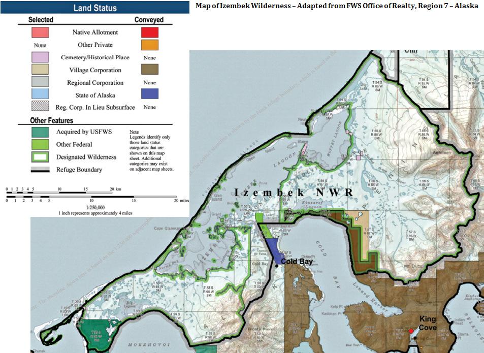
43
Hudson Bay Lowlands Proposed Protected Areas
 Hudson Bay Lowlands Proposed Protected Areas Hudson Bay Lowlands Proposed Protected Areas The Protected Areas Initiative has identified portions of the Hudson Bay Lowlands region that have significant
Bering Sea Ecoregion Strategic Action Plan
 Bering Sea Ecoregion Strategic Action Plan Part I Map by Shane T. Feirer The Nature Conservancy in Alaska First Iteration September 2005 Part 1. Bering Sea Ecoregion: Strategic Action Plan - First Iteration
PROUDLY BRINGING YOU CANADA AT ITS BEST. Management Planning Program NEWSLETTER #1 OCTOBER, 2000
 PROUDLY BRINGING YOU CANADA AT ITS BEST VUNTUT NATIONAL PARK Management Planning Program NEWSLETTER #1 OCTOBER, 2000 INTRODUCTION This newsletter launches the development of the first management plan for
WORKSHEET 1 Wilderness Qualities or Attributes Evaluating the Effects of Project Activities on Wilderness Attributes
 WORKSHEET 1 Wilderness Qualities or Attributes Evaluating the Effects of Project Activities on Wilderness Attributes Date: 3/7/2017 Roadless Area: Ruby South Description of Project Activity or Impact to
Alaskan/Fjordland Pacific (Ecoregion 22)
") Alaskan/Fjordland Pacific (Ecoregion 22) Background The Alaskan/Fjordland Pacific Ecoregion is an area of abundant marine resources. The ecoregion begins at Vancouver Island and moves up the Gulf of Alaska
Alaskan/Fjordland Pacific (Ecoregion 22) Background The Alaskan/Fjordland Pacific Ecoregion is an area of abundant marine resources. The ecoregion begins at Vancouver Island and moves up the Gulf of Alaska
Overview. Wilderness Act of Statement of Need. What is Wilderness Character. Monitoring Wilderness Character
 Overview Monitoring Wilderness Character What What & Why? How? How? Conceptual Development How? How? Implementation Future? Future? Troy Hall Steve Boutcher USFS Wilderness & Wild and Scenic River Program
Continental Divide National Scenic Trail Legislative History and Planning Guidance
 Continental Divide National Scenic Trail Legislative History and Planning Guidance Legislation, Policy, and Direction Regarding National Scenic Trails The National Trails System Act, P.L. 90-543, was passed
Public Lands in Alaska. 200 million acres of federal land - Over 57 Million acres of Wilderness more than half the Wilderness in the entire nation
 Public Lands in Alaska 200 million acres of federal land - Over 57 Million acres of Wilderness more than half the Wilderness in the entire nation alaskawild.org Ground Zero for Climate Change Over the
National Park Service Wilderness Action Plan
 National Park Service U.S. Department of the Interior National Park Service Wilderness Action Plan National Wilderness Steering Committee National Park Service "The mountains can be reached in all seasons.
Bon Portage Island Conservation Campaign
 Bon Portage Island Conservation Campaign Protecting a Coastal Treasure Final Report to Nova Scotia Habitat Conservation Fund September 2012 Protection of Bon Portage Island Over the course of this two-year
Arthur Carhart National Wilderness Training Center s Wilderness Investigations High School
 Arthur Carhart National Training Center s Investigations High School 101/Lesson 2 (OPTION 2B) Introducing the Act Goal: Students will understand the difference between wild spaces and federally designated
Underwater Acoustic Monitoring in US National Parks
 Underwater Acoustic Monitoring in US National Parks Megan F McKenna 1, Christopher Garsha 2, Erik Stabenau 1, Christine Gabriele 1, Timothy Clark 1, Clayton Pollock 1, Brinnen Carter 1, Samantha Bietsch
Finn Creek Park. Management Direction Statement Amendment
 Finn Creek Park Management Direction Statement Amendment November 2013 Management Direction Statement Amendment Approved by: Jeff Leahy Regional Director, Thompson Cariboo BC Parks November 12, 2013 Date
Rule Governing the Designation and Establishment of All-Terrain Vehicle Use Trails on State Land
 Rule Governing the Designation and Establishment of All-Terrain Vehicle Use Trails on State Land 1.0 Authority 1.1 This rule is promulgated pursuant to 23 V.S.A. 3506. Section 3506 (b)(4) states that an
VARGAS ISLAND PROVINCIAL PARK
 VARGAS ISLAND PROVINCIAL PARK PURPOSE STATEMENT AND ZONING PLAN February 2003 VARGAS ISLAND PROVINCIAL PARK Purpose Statement and Zoning Plan Primary Role The primary role of Vargas Island Park is to protect
What is an Marine Protected Area?
 Policies, Issues, and Implications of Marine Protected Areas Kara Anlauf University of Idaho Before the House Subcommittee on Fisheries Conservation, Wildlife and Oceans April 29, 2003 What is an Marine
WILDERNESS PLANNING. Wilderness. Interagency Regional Wilderness Stewardship Training. Alamosa, Colorado - March 26-29, 2007
 WILDERNESS PLANNING Interagency Regional Wilderness Stewardship Training Alamosa, Colorado - March 26-29, 2007 Suzanne Stutzman Lead Planner/Wilderness Coordinator National Park Service, Intermountain
Wilderness Stewardship Plan Scoping Newsletter Winter 2013
 Olympic National Park National Park Service U.S. Department of the Interior Wilderness Stewardship Plan Scoping Newsletter Winter 2013 Dear Friends and Neighbors, The Olympic Wilderness was established
Wilderness Areas Designated by the White Pine County bill
 Wilderness Areas Designated by the White Pine County bill SEC. 321. SHORT TITLE. This subtitle may be cited as the `Pam White Wilderness Act of 2006'. SEC. 322. FINDINGS. Congress finds that-- The White
APPENDIX A TERMS OF DESIGNATION
 247 248 ABOUT THIS DOCUMENT On May 11, 1994 the National Oceanic and Atmospheric Administration (NOAA) published the final Olympic Coast National Marine Sanctuary Regulations (59 FR 24586). This official
Michipicoten Island Regional Plan
 Michipicoten Island Regional Plan This is one of twenty Regional Plans that support implementation of the Lake Superior Biodiversity Conservation Strategy (Strategy). The Strategy, prepared and overseen
Virginian Atlantic (Ecoregion 8)
") Virginian Atlantic (Ecoregion 8) Background The Virginian Atlantic Ecoregion extends from the south side of Cape Cod to Cape Hatteras in North Carolina. The waters of the ecoregion are a mix of cold and
Virginian Atlantic (Ecoregion 8) Background The Virginian Atlantic Ecoregion extends from the south side of Cape Cod to Cape Hatteras in North Carolina. The waters of the ecoregion are a mix of cold and
Alternative 3 Prohibit Road Construction, Reconstruction, and Timber Harvest Except for Stewardship Purposes B Within Inventoried Roadless Areas
 Roadless Area Conservation FEIS Summary Table S-1. Comparison of Key Characteristics and Effects by Prohibition Alternative. The effects summarized in this table A would occur in inventoried roadless areas
2.0 PARK VISION AND ROLES
 2.0 PARK VISION AND ROLES 2.1 Significance in the Protected Area System Marble Range and Edge Hills provincial parks protect 6.8% of the Pavillion Ranges Ecosection, which is located in the Southern Interior
Twelve Apostles Marine National Park Australia
 EVALUATION REPORT Twelve Apostles Marine National Park Australia Location: Victoria, Australia coastal waters Global Ocean Refuge Status: Nominated (2017), Evaluated (2017) MPAtlas.org ID: 7703885 Manager(s):
Bering Land Bridge National Preserve. is a subset of Beringia, a former massive land bridge between Asia and North America during ice ages.
 BERING LAND BRIDGE NATIONAL PRESERVE Purposes, Natural & Cultural Resources, and Facilities Bud Rice, Environmental Protection Specialist, NPS Alaska Region Bering Land Bridge National Preserve is a subset
Mackinnon Esker Ecological Reserve Draft - Management Plan
 Mackinnon Esker Ecological Reserve Draft - Management Plan May 2011 Photo Credit: This document replaces the direction provided in the Carp Lake Provincial Park and Protected Area and Mackinnon Esker Ecological
BROUGHTON ARCHIPELAGO PROVINCIAL PARK
 BROUGHTON ARCHIPELAGO PROVINCIAL PARK PURPOSE STATEMENT AND ZONING PLAN March 2003 BROUGHTON ARCHIPELAGO PROVINCIAL PARK Purpose Statement and Zoning Plan Primary Role The primary role is to contribute
Decision Memo Broken Wheel Ranch Equestrian Outfitter Special-Use Permit Proposed Action
 Decision Memo Broken Wheel Ranch Equestrian Outfitter Special-Use Permit USDA Forest Service Mississippi Bluffs Ranger District, Shawnee National Forest Jackson and Union Counties, Illinois Proposed Action
We, Ministers, assembled in Berlin for the International Conference on Biodiversity and Tourism from 6 to 8 March 1997
 March 8th, 1997 Berlin Declaration BIOLOGICAL DIVERSITY AND SUSTAINABLE TOURISM We, Ministers, assembled in Berlin for the International Conference on Biodiversity and Tourism from 6 to 8 March 1997 -
The Roots of Carrying Capacity
 1 Applying Carrying Capacity Concepts in Wilderness 1872 1964...shall be preserved for the use & enjoyment of the American people...in such manner as will leave them unimpaired for future generations...
Creation of a Community-managed Biodiversity Park in the Saloum Delta of Senegal. Voré Gana Seck Director GREEN Senegal for People, Land, Ocean
 Creation of a Community-managed Biodiversity Park in the Saloum Delta of Senegal Voré Gana Seck Director GREEN Senegal for People, Land, Ocean Rationale for the Creation of the Biodiversity Park F In line
Terrestrial Protected Area Nomination: Central Mangrove Wetland South-West, Grand Cayman
 Terrestrial Protected Area Nomination: Central Mangrove Wetland South-West, Grand Cayman The attached nomination, proposing that a parcel of land in the Central Mangrove Wetland be made a Protected Area
Terms of Reference (ToR) for a Short-Term assignment
 for a Short-Term assignment") Terms of Reference (ToR) for a Short-Term assignment Technical assistance requested Expert for climate change mitigation and adaptation Project Title Outline of the Climate Adaptation Strategy and basin-wide
Terms of Reference (ToR) for a Short-Term assignment Technical assistance requested Expert for climate change mitigation and adaptation Project Title Outline of the Climate Adaptation Strategy and basin-wide
MINIMUM REQUIREMENTS DECISION GUIDE WORKSHEETS
 ARTHUR CARHART NATIONAL WILDERNESS TRAINING CENTER MINIMUM REQUIREMENTS DECISION GUIDE WORKSHEETS Prescribed burning of islands within Okefenokee Wilderness Area.... except as necessary to meet minimum
Sand Lakes Provincial Park. Draft Management Plan
 Sand Lakes Provincial Park Draft Management Plan 2 Sand Lakes Provincial Park Table of Contents 1. Introduction... 3 2. Background... 3 3. Park Purpose... 5 4. Park Management Guidelines... 6 Appendix...
Order of the Minister of Environment #39, August 22, 2011 Tbilisi
 Registration Code 360050000.22.023.016080 Order of the Minister of Environment #39, August 22, 2011 Tbilisi On preparatory stages and procedure of the methodology for Elaborating structure, content and
Daisy Dean Trail 628/619 ATV Trail Construction
 Background and Purpose and Need The Daisy Dean ATV Trail Construction Project is located in the Little Belt Mountains, Musselshell Ranger District, Lewis and Clark National Forest approximately 32 miles
Labrador - Island Transmission Link Target Rare Plant Survey Locations
 27-28- Figure: 36 of 55 29-28- Figure: 37 of 55 29- Figure: 38 of 55 #* Figure: 39 of 55 30- - east side Figure: 40 of 55 31- Figure: 41 of 55 31- Figure: 42 of 55 32- - secondary Figure: 43 of 55 32-
Applying Carrying Capacity Concepts in Wilderness
 Applying Carrying Capacity Concepts in Wilderness...shall be preserved for the use & enjoyment of the American people...in such manner as will leave them unimpaired for future generations... CSS 490 Professor
Backgrounder Plains Bison Reintroduction to Banff National Park
 Backgrounder Plains Bison Reintroduction to Banff National Park Introduction The five-year reintroduction project is a small- scale initiative that would inform future decisions regarding the feasibility
White Mountain National Forest Saco Ranger District
 United States Department of Agriculture Forest Service White Mountain National Forest Saco Ranger District 33 Kancamagus Highway Conway, NH 03818 Comm: (603) 447-5448 TTY: (603) 447-3121 File Code: 1950
MANAGEMENT DIRECTION STATEMENT June, 1999
 Thompson River District MANAGEMENT DIRECTION STATEMENT June, 1999 for Roche Lake Provincial Park Ministry of Environment Lands and Parks BC Parks Division Table of Contents I. Introduction A. Setting
MAIN LAKE PROVINCIAL PARK
 MAIN LAKE PROVINCIAL PARK PURPOSE STATEMENT AND ZONING PLAN March 2003 MAIN LAKE PROVINCIAL PARK Purpose Statement and Zoning Plan Primary Role The primary role of Main Lake Park is to protect a biologically
Wilderness Character and Wilderness Characteristics. What s the difference? Why does it matter?
 Introduction Wilderness Character and Wilderness Characteristics What s the difference? Why does it matter? The terms wilderness character and wilderness characteristics are sometimes used interchangeably
Draft Resolution on wetlands in polar and subpolar regions
 RAMSAR CONVENTION ON WETLANDS 54th Meeting of the Standing Committee Gland, Switzerland, 23 27 April 2018 Submitted by Sweden Draft Resolution on wetlands in polar and subpolar regions SC54-Com.15 (21.14)
Mark West Creek Flow Study Report
 Mark West Creek Flow Study Report Biology and Geology of Mark West Creek The headwaters of Mark West Creek are located in the Mayacamas Mountain range, which border Napa and Sonoma County, where it then
Section 2 North Slope Ecoregions and Climate Scenarios
 Section 2 North Slope Ecoregions and Climate Scenarios North Slope Ecoregions The geographic/ecological scope of the workshop will be freshwater and terrestrial systems of the North Slope of Alaska, with
Marchand Provincial Park. Management Plan
 Marchand Provincial Park Management Plan 2 Marchand Provincial Park Table of Contents 1. Introduction... 3 2. Park History... 3 3. Park Attributes... 4 3.1 Natural... 4 3.2 Recreational... 4 3.3 Additional
Colorado Life Zone Scavenger Hunt
 Colorado Life Zone Scavenger Hunt Below are worksheets created for all the habitats or life zones. They were designed with the intention of breaking the class up into small groups, and having students
The Partnership Wild & Scenic Rivers Program
 BUDGET REQUEST FISCAL YEAR 2017 Proven, cost-effective protection for 770 miles of rivers and thousands of acres of riparian land Westfield River, MA (L) and Farmington River, CT (R) Partnership Wild &
TOWARDS SUSTAINABLE MANAGEMENT OF MARINE AND COASTAL HABITATS ASIA- PACIFIC DAY FOR THE OCEAN
 TOWARDS SUSTAINABLE MANAGEMENT OF MARINE AND COASTAL HABITATS WANNAKIAT THUBTHIMSANG PHUKET MARINE BIOLOGICAL CENTER, DMCR, THAILAND ASIA- PACIFIC DAY FOR THE OCEAN 20 NOVEMBER 2018, CONFERENCE ROOM 4,
Draft LAW. ON SOME AMENDAMENTS IN THE LAW No.9587, DATED ON THE PROTECTION OF BIODIVERSITY AS AMENDED. Draft 2. Version 1.
 Technical Assistance for Strengthening the Capacity of the Ministry of Environment, Forests and Water Administration in Albania for Law Drafting and Enforcement of National Environmental Legislation A
INFORMATION NOTICE 15-2 Limited & Excluded Lands
 INFORMATION NOTICE 15-2 Limited & Excluded Lands Schedule 1 (Land Description) of onshore petroleum Agreements issued by the Department of Energy details the total hectares calculated. Total hectares are
Global Sustainable Tourism Destinations Criteria
 Global Sustainable Tourism Destinations Criteria Draft destination level Global Sustainable Tourism Criteria as proposed after Destinations and International Standards joint working group meeting and follow-up
Numaykoos Lake Provincial Park. Management Plan
 Numaykoos Lake Provincial Park Management Plan 2 Numaykoos Lake Provincial Park Table of Contents 1. Introduction... 3 2. Background... 3 3. Park Purpose... 5 4. Park Management Guidelines... 6 Appendix...
Wilderness Research. in Alaska s National Parks. Scientists: Heading to the Alaska Wilderness? Introduction
 Wilderness Research in Alaska s National Parks National Park Service U.S. Department of Interior Scientists: Heading to the Alaska Wilderness? Archeologist conducts fieldwork in Gates of the Arctic National
MARBLE RIVER PROVINCIAL PARK
 MARBLE RIVER PROVINCIAL PARK PURPOSE STATEMENT AND ZONING PLAN March 2003 MARBLE RIVER PROVINCIAL PARK Purpose Statement and Zoning Plan Primary Role The primary role of Marble River Park is to protect
 AGREEMENT Between Director of the Białowieża National Park, based in Białowieża (Poland) and Director of the National Park Bialowieża Forest, based in Kamieniuki (Belarus) and Head Forester of the Białowieża
Recreation Opportunity Spectrum for River Management v
 Recreation Opportunity Spectrum for Management v. 120803 Introduction The following Recreation Opportunity Spectrum (ROS) characterizations and matrices mirror the presentation in the ROS Primer and Field
LATIN AMERICA / CARIBBEAN COIBA NATIONAL PARK PANAMA
 LATIN AMERICA / CARIBBEAN COIBA NATIONAL PARK PANAMA WORLD HERITAGE NOMINATION IUCN TECHNICAL EVALUATION COIBA NATIONAL PARK (PANAMA) ID Nº 1138 Bis Background note: Coiba National Park was nominated for
Yard Creek Provincial Park. Management Plan
 Yard Creek Provincial Park Management Plan Draft January 2010 Yard Creek Provincial Park Management Plan Approved by: telàlsemkin/siyam/chief Scott Benton Bill Williams Squamish Executive Director ation
National Wilderness Steering Committee
 National Wilderness Steering Committee Guidance White Paper Number 1 Issue: Cultural Resources and Wilderness Date: November 30, 2002 Introduction to the Issue Two of the purposes of the National Wilderness
4) Data sources and reporting ) References at the international level... 5
 Data sources and reporting ) References at the international level... 5") D- 1: Protected areas (PA) 1) General description... 2 1.1) Brief definition... 2 1.2) Units of measurement... 2 1.3) Context...2 2) Relevance for environmental policy... 2 2.1) Purpose... 2 2.2) Issue...
D- 1: Protected areas (PA) 1) General description... 2 1.1) Brief definition... 2 1.2) Units of measurement... 2 1.3) Context...2 2) Relevance for environmental policy... 2 2.1) Purpose... 2 2.2) Issue...
Park Updates 1. Cavalero 2. Lundeen 3. Frontier Heights Citizen Advisory Committee
 Page 1 of 10 PARK BOARD AGENDA Community Center 1808 Main Street, Lake Stevens Monday, April 11, 2016 CALL TO ORDER: 6:00 pm ROLL CALL: GUEST BUSINESS: ACTION ITEMS: A. B. C. Approval of February 8, 2016
A GUIDE TO MANITOBA PROTECTED AREAS & LANDS PROTECTION
 A GUIDE TO MANITOBA PROTECTED AREAS & LANDS PROTECTION Manitoba Wildands December 2008 Discussions about the establishment of protected lands need to be clear about the definition of protection. We will
Recreational Carrying Capacity
 9 th Annual Caribbean Sustainable Tourism Conference Recreational Carrying Capacity Graham C Barrow What is Recreational Carrying Capacity? It s not about fixing absolute numbers of visitors/tourists that
Sawtooth National Forest Fairfield Ranger District
 United States Department of Agriculture Forest Service Sawtooth National Forest Fairfield Ranger District P.O. Box 189 Fairfield, ID. 83327 208-764-3202 Fax: 208-764-3211 File Code: 1950/7700 Date: December
The Frank Church River of No Return Wilderness
 ALLIANCE FOR WILDERNESS EDUCATION AND STEWARDSHIP PO Box 2667, Bellingham, WA 98227-2667 Tele: 360-927-1804 Fax: 360-527-9679 bradt@wildernessalliance.org www.wildernessalliance.org STEWARDS OF AMERICA
Natural and Cultural Resources Management, Part 610: Wilderness Stewardship
 Natural and Cultural Resources Management, Part 610: Wilderness Stewardship 2.5 May the Service allow structures and installations in wilderness? Section 4(c) of the Wilderness Act generally prohibits
MANAGEMENT DIRECTION STATEMENT June, 1999
 Thompson River District MANAGEMENT DIRECTION STATEMENT June, 1999 for Clearwater River Corridor (Addition to Wells Gray Park) Ministry of Environment Lands and Parks BC Parks Division ii Table of Contents
MARINE PROTECTED AREAS LESSON PLAN Water Parks
 Marine Protected Areas U. S. Marine Protected Areas Lesson Plan MARINE PROTECTED AREAS LESSON PLAN Water Parks Theme U.S. Marine Protected Areas Links to Overview Essays and Resources Needed for Student
Friday, Day One. Saturday, Day Two Travel the Inside Passage thru Canada (no Passport required) Sunday, Day Three
 Sunday, Day Three") 2015 : 15 Day Glacier & Wildlife Tour (Easily modified to 12 Days with return by Air) Tour : 1395 Number Travel Arrangements: US$4,100.00 per person, based on two people traveling together. Senior rate
2015 : 15 Day Glacier & Wildlife Tour (Easily modified to 12 Days with return by Air) Tour : 1395 Number Travel Arrangements: US$4,100.00 per person, based on two people traveling together. Senior rate
As outlined in the Tatshenshini-Alsek Park Management Agreement, park management will:
 Management Strategy General Strategy The priority management focus for the park is to ensure that its internationally significant natural, cultural heritage and recreational values are protected and that
Access: The rocky shoreline is only accessible via private property.
 10. Whale Cove Site description: Whale Cove is a small cove fringed by private homes and condominiums with diverse and relatively undisturbed rocky intertidal and subtidal habitat located approximately
SENSITIVE AREAS: PART FIVE - AREAS OF LOCAL CONCERN
 S: PART FIVE - AREAS OF LOCAL CONCERN Some areas within the Cook Inlet Subarea warrant special attention due to the presence of highly productive wildlife habitat, the ability to sustain a large part of
Pinellas County Environmental Lands
 Pinellas County Environmental Lands In addition to traditional parks and recreation facilities, Pinellas County owns and manages a system of environmental lands that provides specialized resource-based
Title/Name of the area: Chwaka Bay, Zanzibar
 Title/Name of the area: Chwaka Bay, Zanzibar Presented by: Dr. Charles Lugomela, Ag. Head, Department of Aquatic Sciences and Fisheries, University of Dar es Salaam, P.O. Box 35064 Dar es Salaam, Tanzania
(4) Protected Areas in Japan 4-1) Outlines of Protected Area Systems in Japan
 Protected Areas in Japan 4-1) Outlines of Protected Area Systems in Japan") (4) Protected Areas in Japan 4-1) Outlines of Protected Area Systems in Japan a) Protected Areas System Under the Nature Conservation Law 1) Wilderness Areas To conserve primeval natural environment, natural
(4) Protected Areas in Japan 4-1) Outlines of Protected Area Systems in Japan a) Protected Areas System Under the Nature Conservation Law 1) Wilderness Areas To conserve primeval natural environment, natural
Status of Antillean Manatees in Belize
 Status of Antillean Manatees in Belize Belize regional stronghold of the Antillean Manatee (Trichechus manatus manatus) Belize population is estimated to be in the region of 800 to 1000 animals Highest
Appendix 1: Best Management Practices For Hang Gliding and Paragliding in Jasper National Parks
 Appendix 1: Best Management Practices For Hang Gliding and Paragliding in Jasper National Parks Name of Best Management Practice Best Management Practices for Hang Gliding and Paragliding in Jasper National
PURPOSE AND NEED. Introduction
 Public Scoping: Allocation of Recreation Capacity for Commercial Outfitter Guide Services on North Kruzof Island Trails (Kruzof Island Outfitter Guide) PURPOSE AND NEED Introduction The U.S. Department
Eco Explorer. Steps. Purpose
 Eco Explorer A n eco explorer is a person who investigates environmental issues and works to make positive changes to the environment. In this badge, you ll be an eco explorer as you take a look at different
April 10, Mark Stiles San Juan Public Lands Center Manager 15 Burnett Court Durango, CO Dear Mark,
 Mark Stiles San Juan Public Lands Center Manager 15 Burnett Court Durango, CO 81301 Dear Mark, We are pleased to offer the following comments on the draft San Juan Public Lands Center management plans
Cat Island Chain Background & Access Guide
 Cat Chain Background & Access Guide Brown County Port & Resource Recovery Department 2561 S. Broadway, Green Bay, WI 54304 (920) 492-4950 www.portofgreenbay.com January 2018 1 Restoration of the Cat Chain
THRESHOLD GUIDELINES FOR AVALANCHE SAFETY MEASURES
 BRITISH COLUMBIA MINISTRY OF TRANSPORTATION & INFRASTRUCTURE AVALANCHE & WEATHER PROGRAMS THRESHOLD GUIDELINES FOR AVALANCHE SAFETY MEASURES British Columbia Ministry of Transportation & Infrastructure
Appendix A BC Provincial Parks System Goals
 Appendix A BC Provincial Parks System Goals The British Columbia Provincial Parks System has two mandates: To conserve significant and representative natural and cultural resources To provide a wide variety
BACKGROUND DECISION. Decision Memo Page 1 of 6
 DECISION MEMO DEVIL S ELBOW BY-PASS, BOUNDARY TRAIL NO.1 U.S. FOREST SERVICE T9N, R7E, SECTION 9 RANGE 5E COWLITZ COUNTY WA MOUNT ST. HELENS NATIONAL VOLCANIC MONUMENT, GIFFORD PINCHOT NATIONAL FOREST
MANAGEMENT DIRECTION STATEMENT March 2003
 Skeena Region MAAGEMET DIRECTIO STATEMET March 2003 for Meziadin Lake Provincial Park Ministry of Water, Land and Air Protection Environmental Stewardsh Division This page left blank on purpose ii Table
Network of International Business Schools
 Network of International Business Schools WORLDWIDE CASE COMPETITION Sample Case Analysis #1 Qualification Round submission from the 2015 NIBS Worldwide Case Competition, Ottawa, Canada Case: Ethiopian
Connie Rudd Superintendent, Black Canyon of the Gunnison National Park
 National Park Service U.S. Department of the Interior Black Canyon of the Gunnison National Park and Curecanti National Recreation Area Information Brochure #1 Wilderness and Backcountry Management Plan
Inholdings within Wilderness: Legal Foundations, Problems, and Solutions
 In the western United States, land inholdings in wilderness are largely a result of five legislative acts: the 1872 Mining Law (17 Stat. 91), the 1862 Homestead Act (12 Stat. 392), the 1864 and 1870 Land
RE: Access Fund Comments on Yosemite National Park Wilderness Stewardship Plan, Preliminary Ideas and Concepts
 September 30, 2016 Superintendent Yosemite National Park Attn: Wilderness Stewardship Plan P.O. Box 577 Yosemite, CA 95389 RE: Access Fund Comments on Yosemite National Park Wilderness Stewardship Plan,
Subtitle B Unmanned Aircraft Systems
 H. R. 658 62 (e) USE OF DESIGNEES. The Administrator may use designees to carry out subsection (a) to the extent practicable in order to minimize the burdens on pilots. (f) REPORT TO CONGRESS. (1) IN GENERAL.
7 REGIONAL OVERVIEW 2
 7 REGIONAL OVERVIEW 2 Alaska s Marine Highway: Kodiak And The Aleutians Segment Corridor Plan 9 2 REGIONAL OVERVIEW This segment of Alaska s Marine Highway extends from the western portion of the Prince
SeagrassNet Monitoring in Great Bay, New Hampshire, 2016
 University of New Hampshire University of New Hampshire Scholars' Repository PREP Reports & Publications Institute for the Study of Earth, Oceans, and Space (EOS) 9-28-2017 SeagrassNet Monitoring in Great
DECISION MEMO. Rawhide Trail #7073 Maintenance and Reconstruction
 Page 1 of 6 Background DECISION MEMO USDA Forest Service Jefferson Ranger District Jefferson County, Montana Rawhide Trail #7073 is located in the Elkhorn Mountain Range approximately 10 miles east of
REGIONAL AGREEMENT AND FRAMEWORK FOR MARINE MAMMALS CONSERVATION IN THE WCR: THE SPAW PROTOCOL AND THE MARINE MAMMAL ACTION PLAN
 REGIONAL AGREEMENT AND FRAMEWORK FOR MARINE MAMMALS CONSERVATION IN THE WCR: THE SPAW PROTOCOL AND THE MARINE MAMMAL ACTION PLAN ALESSANDRA VANZELLA-KHOURI SPAW Programme Officer United Nations Environment
Boatswain bay biodiversity reserve
 Boatswain bay biodiversity reserve March 2003 1 1. Plan and description 1.1. Geographic location, boundaries and dimensions The plan of the proposed Boatswain bay biodiversity reserve and its location
Case Study: 1. The Clarence River Catchment
 Case Study: 1. The Clarence River Catchment The NSW coastline is a great natural asset, making an enormous contribution to the economy. The resources of coastal catchments such as the Clarence River Catchment,