February 15, Cam Hooley, Project Leader Hermosa Creek SMA Plan P.O. Box 439 Bayfield, CO 81122
|
|
|
- Kellie Beasley
- 5 years ago
- Views:
Transcription
1 February 15, 2016 Cam Hooley, Project Leader Hermosa Creek SMA Plan P.O. Box 439 Bayfield, CO Reference: Hermosa Special Management Area (SMA) Plan comment Dear Cam Hooley, This is a huge undertaking for you to be the leader in developing a management plan for the Hermosa. I know the country is complicated on the ground; planning would be the same. Good luck! This is my background that supports credible views of the Hermosa the may help with this planning. My experience in the Hermosa starts in At that time I worked to cook, wrangler and guide for a number of hunt outfits; and rode the cows/monitored for the Dutch Creek Grazing Allotment. Today I hold a USFS summer-use horse outfitter permit (includes East Hermosa), do range monitoring for the Dutch Creek Grazing Allotment and work my horses for other outfits during fall hunt. I produce beef and hay and raise horses on the Animas River near the confluence with Hermosa Creek since Big game wildlife is a ranch management challenge that caused me to attend monthly meetings for the San Juan Basin Habitat Partnership Program (HPP) that began in HPP is funded by big game hunting license sales administered by Colorado State Parks and Wildlife. I serve as a committee member today. I think a lot about big game management all over the San Juan Basin. HPP strives toward a balance so everything is happy; the forage, the animals, the people. We support projects for big game wildlife so they are tolerated on private lands during the winter months. We support projects to enhance migration routes and habitat so these animals utilize public lands spring thru fall. I and other ranchers welcome the deer and elk in the Animas Valley during the winter months when public land is their permanent address the rest of the year. The USFS, HPP and Rocky Mountain Elk Foundation have partnered to accomplish habitat improvement projects in the Lower East Hermosa to support this. You should know I feel steamrolled by the Hermosa Creek Workgroup process that began as a discussion group for river protection that later morph into land protection. The group anointed themselves to be knowledgeable and their diligence created momentum to pass legislation. I was shocked to read the workgroup's draft report and meeting minutes. The minutes showed there was no discussion for understanding big game wildlife in the Hermosa. They discussed trout. It was not fun to have to use my big mouth in the 11th hour in front of 120 people so that big game wildlife would at least be mentioned under "other" in the final report. No one in the meeting room wanted to hear me say that it will suck th'.' oxygen out of the East Hermosa for the other uses, if you increase people's recreation opportunity there. This concern was rebuked by this statement added in their final report; that their interest is to be able to recreate in the way one wishes to (on certain trails, in quiet-use situations, in motorized situations; using equipment that one! 1

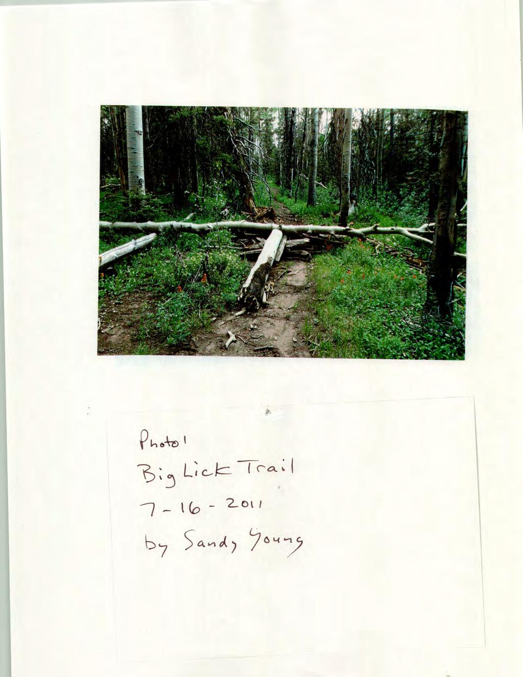
2 wishes to, etc. etc.)!t's clear to me the workgroup's prioi'ities were trout habitat, recreation opportunity and a wilderness designation. How far this group's energy carries into planning; it remains to be seen. So quickly the Hermosa is going down as not so beautiful. Why are too many people not enough? The Hermosa was the best kept secret close to Durango; relatively unchanged for a very long time. Now the Hermosa is nationally rec~gnized and too many people want to visit. Dispersed camping along FS Road 576 was banned in The volunteer effort to help create the Lower Hermosa Campground will soon be a fee area. The elk may likely move to Rico while too many spoiled bears remain to eat garbage. The East and West Hermosa is one-country to me and for big game wildlife too; seen by the way they travel and inhabit the place.!twas my view the Hermosa should be designated all wilderness or none at all. What's left for me to say now is YES to answer your question 1 "Should a Wilderness Management Plan be considered at the same time as the SMA Plan?" Question 2 Are there specific problems that should be addressed in the Hermosa Creek Plan? My answer is YES; two problems. Problem 1 Too much recreational activity in East Hermosa will displace big game wildlife. The elk calve in the East Hermosa, not in the steep country on the west side. The Hermosa was generally used seasonally June November way back when before Then the sport of mountain bicycling began. They call their use historic but it's not. I first saw Dan Feller ride a mountain bike on the Hermosa Trail in He was a local farmer's son who built bikes. Enclosed is a study that supports my concern for too much recreation activity occurring in critical big game habitat titled "Behavioral Responses of North American Elk to Recreational Activity." The Durango area has exploded with bicycle riders; they ride the streets and in the back country. Bicycle makers can't develop bikes fast enough to feed the appetite of people who constantly need a new bike challenge; skinny tire, fat tire, snow bikes, downhill bikes, whatever. The back country should not be the place to appease malcontent people. Photos 1-3 were taken July 16, 2011 on the Big Lick Trail (a!so confusingly known as the Elbert Creek Trail). This blockage is evidence there are people don't care about others. In this case its bicycle people. In a short time we have gone from no bicycle use in Big Elk Canyon and the Little Elk Trail to considerable use and too early in the spring. Elk calve here in June. Photo 4 was taken June 16, 2013 on the Little Elk Trail just below the Little Elk Cabin. I was only there to monitor the water resources to assist the cattlemen in making critical decisions for grazing in a dry year; otherwise cattle grazing rarely impact this area before mid-july. It is my understanding the Little Elk Trail is not a USFS system trail; cattlemen and hunting outfitters maintain the trail. At this time the trail is not well-suited for bicycle use; the photo shows they can't stay on the trail. More importantly, people need to stay out of these areas so elk can peacefully give birth. :n 2015 Trails 2000 posted on its website a Trail Conditions report for everyone to know that in February the Hermosa Creek trail was in fair condition but open (a girl posted a picture of herself off her bicycle in mud and snow). Trails 2000 is the driver to cause recreational use to occur year round in the East Hermosa. If they would simply stop advertising it would at least slow the momentum for this exploding use. I sent a letter to Trails 2000 in December, 2015 to suggest this. 2

3 A lot of money has been spent on projects to help keep big game wildlife on public lands in the Hermosa. I recommend a seasonal closure to keep people out of the Lower East Hermosa area from December 1-May 15 each year in support for big game wildlife habitat and elk calving. Problem 2 In 2011 the USFS used heavy equipment to cut ditches on the road at the Goulding Creek Trail head that eliminated truck & trailer turn around and parking there. A new sign was installed to let more people know about the trailhead. Today there are more parked cars for hikers. I have to risk damaging my truck & trailer to have access to go to work with horses. A bigger drain was made across the road. It is an extreme dip that will smash the tailgate of a pick-up truck puliing a trailer. I talked to the District Ranger. I was called a whining special interest. Later he told me he talked to the cattlemen and they don't have a problem. I talked to the cattlemen. There was no discussion with them. Why lie? I talked to Pete Merkel at a RAC meeting in He said he would check it out and get back to me. Nice guy but no answer. I have offered to do a site visit with someone. I have offered to a file of photos to show the concern. What more can I do. I have an outfitter permit and I work for the cattlemen in the East Hermosa. Goulding Creek is one of three access points for the east Hermosa to get work done. The trail head has been compromised and nobody cares. Question 3 Are there changes to motorized, mechanized or non-motorized travel management that you would like to see? Include summer and winter. Changes you ask? If the East Hermosa was mine to manage, I would only allow motorized trail use on these trails; the entire length of the Hermosa Creek Trail, and the Jones Creek Trail to the Pinkerton Flagstaff trail then down and out the Mitchell Lakes area. This is now only a dream. This is a request likely impossible to implement; limit the number of motorized riders that travel in a group. I've encountered 3 groups in recent years, two on the Hermosa Trail (14 riders and 15 riders), and one in Jones (7 riders). The bigger the group, the greater the noise, dust and exhaust plume. This does not compliment the wilderness area very well. Winter Use I reiterate that I think it is prudent to maintain a seasonal closure for wildlife December 1-May 15 in the Lower East Hermosa that includes these trails; Hermosa Creek Trail, Elbert Creek Trail, Big Lick Trail, Little Elk Trail, Dutch Creek Trail, Pinkerton-Flagstaff Trail, Goulding Creek Trail and Jones Creek Trail. Over snow use at Purgatory, Hermosa Park, Relay Creek Road, Cascade Divide Road, areas toward Hermosa Peak, etc. seems acceptable. I don't know what the lynx think about this. Summer Use I attended the August 21, 2015 USFS field trip that took us along the entire non-motorized stretch of the Dutch Creek Trail. I was surprised motorized users were absent. USFS Don Kelly spoke for them to say motorized users prefer loop experiences. Here is my list of arguments against motorizing this upper section of the Dutch Creek Trail. 1. Over the years I have read most all the travel management documents produced by the San Juan National Forest. I kick myself for not knowing the travel management document that sounded very reasonable to say efforts will be made to choose motorized trails that use canyon bottoms so the noise 3
4 is contained; and not allow motorized travel in areas where they can go off trail in open parks. I think this is reasonable criteria for everyone to accept. The non-motorized portion of the Dutch Creek Trail runs on top the main ridge between Dutch Creek and the Animas River. This stretch of trail goes through the biggest open parks in the Lower East Hermosa in Dutch Creek. 2. Don Kelly stated that motorized users prefer loop experiences. If the non-motorized stretch of the Dutch Creek Trail is motorized, it connects these people to the start of the non-motorized Little Elk Trail at the Strawberry Patch. What will keep these people who prefer loop experiences from not riding a loop using the non-motorized Little Elk Traii? Photo 5 taken on August 1, 2014 just below the Little Elk Cabin, shows that motorcycle riders are already illegally using the non-motorized Little Elk Trail. Why make a decision that will enable the rule breakers more? This illegai use increases the risk that vandalism is likely to occur to the Little Elk Cabin. 3. If the non-motorized Dutch Creek Trail is motorized, the end of Eibert Creek Road (Strawberry Patch) trail head will become the most attractive site for motorized users to camp. Currently this trail head fills weli beyond capacity at times during the hunting seasons. Elbert Creek Road becomes most narrow between Elbert Creek and the Strawberry Patch in Line Canyon. Did you know that a truck and trailer with horses rolled off Elbert Creek Road on a steep open hillside in Line Canyon last summer? The Strawberry Patch is a rudimentary trail head with dispersed camping. If you don't want to drive on mud and grass in wet conditions, there is barely room to turn a truck and trailer around. The USFS recreation budget is shrinking. More services will be cut. Sites are being decommissioned. Why would you want to open a can of worms at the Strawberry Patch? 4. This is an observation that supports a winter trail closure. The Lower Hermosa Trail head is at 6563' elevation. If you go up the motorized Jones Creek Trail, I have marked a GPS waypoint where I first met snow on the trail at 8,626' on June 25, If you continue up the Jones Creek Trail to the Pinkerton Flagstaff Trail and then to the head of Jones Creek, the elevation is 9,850. Photo 6 is the Pinkerton Flagstaff Trail at this elevation where it breaks over the divide between Jones Creek and Stony Gulch. We term the area the Deep Freeze because snow piles up early in the fail and melts out late spring. Unlike other recreation users, motorized users can travel much greater distances in a day outing. Photo 6 is dated June 23, This is evidence that motorized travel that begins in dry conditions at the Lower Hermosa Trailhead will be traveling in snow/mud conditions an hour later. It doesn't get better as they trave! further up the Pinkerton-Flagstaff Trail that generally runs above 10,000'. The Strawberry Patch Trail head is 10,400' elevation. A May 15 trail opening date at the Lower Hermosa Trail head may be ok for motorized use on the Hermosa Creek Trail. The date is not late enough for the other trails when motorized users can reach these higher elevations in an hour. 5. An USFS staff person who works in this non-motorized area of the Dutch Creek Trail spoke off the record to me to say it should be motorized because they are already using it (illegally). Photo 7 dated July 16, 2010 shows very well there is a long history of illegal use on the non-motorized Dutch Creek Trail.!f this stretch becomes motorized, it's a guarantee the end of Elbert Creek Road and Upper Dutch Creek will become a zoo. If it remains non-motorized, rule-abiding folks wili at least turn away keeping use at the reasonable level we have today. Is it the culture at the USFS that if a group does something illegally long enough, they eventually get their way? I heard that the USFS is obligated to replace motorized trails when these users lose trails to the wilderness designation in the West Hermosa. Why? I would like to understand more about this obligation. How do notorious rule breakers maintain their buddy system or receive increased 4
5 opportunity from the USFS? The San Juan National Forest Columbine District trails program has a long history of receiving GOCO motorized recreation grant funding for trail work. Let's not forget that other funding has been provided to support big game habitat in the East Hermosa. A significant elk calving area in Scaffold Timber is an open park away from the non-motorized Dutch Creek Trail. Do you think motorizing this trail will benefit elk? 6. Everyone can agree that American society is increasingly more violent, aggressive, behave unpredictably; whatever you want to describe it. More and more I see people traveling around in their vehicles in the back country very late at night. Why? Drunk? Drugged? In the back country it's commonplace to go to bed and rise with the sun. Today it's concerning to be stuck in a sleeping bag in the back country when there are others going about late at night. As an outfitter responsible for people's safety, I've kept a watchful eye on these changes. Photos 8 & 9 were taken on the Cascade Creek Trail on July 6, These attitudes concern me. These people vandalize, break rules and are disrespectful. How does the USFS accept this behavior and then feel obligated to maintain or increase this user group's opportunities for motorized trails in the back country? 7. Photo 10 was taken July 18, 2013 to show the trail work recently done in a meadow on a motorized stretch of the Pinkerton-Flagstaff Trail near Stag Draw where the Dutch Creek Trail connects. This is the ugliest repair work to a motorized trail I have ever seen. It took a lot of effort (money} to bring this material into this open park. If we have to deface the back country to maintain a motorized trail, then there should not be motorized trails. This is ridiculous. 8. Photos 11 & 12 were taken October 26, This is a motorized section of the Dutch Creek Trail going up from Bondurant Canyon. It shows how bicycles and ORVs wear on the trail. They are scratching/eroding the uphill side of the trail; my guess is to avoid rocks and the water bars. There is evidence out there that shows this undermines the end of the water bar and widens trails. There are plenty of examples on the Jones Creek Trail too; my point being trails for these users are expe'1sive to maintain. 9. last but not least, I set a summer camp in Upper Dutch Creek for non-motorized visitors. If the nonmotorized section of the Dutch Creek Trail becomes motorized, this camp is greatly diminished. It is depressing to have to explain to visitors/clients why the San Juan National Forest has become riddled with motorized use on trails. People are appalled. Question 4 How should we address the small slivers of SMA land on the west and southwest sides of the wilderness? Please, please leave well enough alone. This is rough, steep country that no man has gone and should not go. Trails 2000 people have their eye on building a trail there. It is past time this group is told NO for once. Too much is not enough for some. 5
6
7

8

9

10

11

12

13

14

15

16

17

18
To: Cam Hooley From: Trails 2000 Date: September 30, 2016 Re: Hermosa Comments. Dear Cam:
 ! To: Cam Hooley From: Trails 2000 Date: September 30, 2016 Re: Hermosa Comments Dear Cam: Trails 2000 is commenting on the Forest Service Management Plan for the Hermosa Creek Watershed Management Plan
April 10, Mark Stiles San Juan Public Lands Center Manager 15 Burnett Court Durango, CO Dear Mark,
 Mark Stiles San Juan Public Lands Center Manager 15 Burnett Court Durango, CO 81301 Dear Mark, We are pleased to offer the following comments on the draft San Juan Public Lands Center management plans
Table of Contents. page 3 Long term Goals Project Scope Project History. 4 User Groups Defined Trail Representative Committee. 5 Trail Users Breakdown
 Launched April 27th, 2010 1 Table of Contents page 3 Long term Goals Project Scope Project History 4 User Groups Defined Trail Representative Committee 5 Trail Users Breakdown 13 Trail Users Desires 16
Response to Public Comments
 Appendix D Response to Public Comments Comment Letter # Response 1, 2, 3, 4, 5, 7, 8, 9, 10, 11, 12, 13, 14, 15, 16, 17, 18, 19, 20, 22, 23, 24, 25, 26, 27, 29, 30, 31, 32, 33, 34, 35, 36, 37, 38, 39,
Colorado s forests are slated to lose thousands of miles of roads through the new OHV Route Designation process. DON T LET IT HAPPEN!
 Colorado s forests are slated to lose thousands of miles of roads through the new OHV Route Designation process. DON T LET IT HAPPEN! This packet identifies many roads that you may lose if you don t act.
Piedra River Protection Workgroup Meeting #5 Feb. 21, 2012 Ross Aragon Community Center, Pagosa Springs
 Piedra River Protection Workgroup Meeting #5 Feb. 21, 2012 Ross Aragon Community Center, Pagosa Springs What happened at this meeting? - Identified conservation easements - Discussed In-stream Flows -
Final Recreation Report. Sunflower Allotment Grazing Analysis. July 2015
 Final Recreation Report Sunflower Allotment Grazing Analysis July 2015 Table of Contents Introduction... 3 Affected Environment... 3 Four Peaks Wilderness Area... 3 Dispersed Recreation... 3 Environmental
Hermosa Area Preservation The Colorado Trail Foundation 4/11/2008
 Hermosa Area Preservation The Colorado Trail Foundation 4/11/2008 Legend d o Tr ail NPA - National Protection Area ra NCA - National Conservation Area o e C Th The Colorado Trail lo FS inventoried Roadless
September 14, Comments of the Colorado Trail Foundation On the USFS Scoping Notice of August 13, 2010 RE: the relocation of the CDNST/CT Page 1
 THE COLORADO TRAIL FOUNDATION Comments on the U.S. Forest Service Scoping Notice of August 13, 2010 Regarding the Relocation of THE COLORADO TRAIL AND CONTINENTAL DIVIDE NATIONAL SCENIC TRAIL From La Garita
Non-motorized Trail Plan & Proposal. August 8, 2014
 Town of Star Valley Ranch, Wyoming and the Star Valley Ranch Association in partnership with the USDA Forest Service, Bridger-Teton National Forest, Greys River Ranger District Non-motorized Trail Plan
Trail Assessment Report
 Trail Assessment Report Trail Options for the Bear Creek Canyon located in Pikes Peak Ranger District, Pike National Forest and on Colorado Springs Utility Lands Due to the presence of a unique species
U.S.D.A. FOREST SERVICE KETCHUM RANGER DISTRICT 206 SUN VALLEY ROAD P.O. BOX 2356 KETCHUM, ID (208)
") U.S.D.A. FOREST SERVICE KETCHUM RANGER DISTRICT 206 SUN VALLEY ROAD P.O. BOX 2356 KETCHUM, ID 83340 (208) 622-5371 Road and Trail Report 05/8/2015 More trails opened in Greenhorn this week. Only high elevation
U.S.D.A. FOREST SERVICE KETCHUM RANGER DISTRICT 206 SUN VALLEY ROAD P.O. BOX 2356 KETCHUM, ID 83340 (208) 622-5371 Road and Trail Report 05/8/2015 More trails opened in Greenhorn this week. Only high elevation
Preferred Recreation Recommendations Stemilt-Squilchuck Recreation Plan March 2018
 Preferred Recreation Recommendations Stemilt-Squilchuck Recreation Plan March 2018 Below are the recommended recreation ideas and strategies that package together the various recreation concepts compiled
American Conservation Experience
 ACE Project Report For Tonto National Forest, Arizona Trail Association and Arizona State Parks Title of Project: 4 Peaks Trail Maintenance Award Contract Number: ASP NM11021 Project Partner: Paul Burghard
Oregon Equestrian Trails Mt. Hood Chapter
 Oregon Equestrian Trails Mt. Hood Chapter November 17, 2010 To: Michelle Lombardo, Mt. Hood National Forest From: Barb Adams, Oregon Equestrian Trail, Mt. Hood Chapter Re: Barlow and Hood River Ranger
Twin Rivers Annual Report 2017
 Twin Rivers Annual Report 2017 Summary of our volunteer efforts for 2017 Volunteer Hours 2249 hours Trail Miles Cleared 37 miles Vehicle Miles Driven 10198 miles Equipment Hours 79 hours Stock Days 193
FINAL TESTIMONY 1 COMMITTEE ON RESOURCES UNITED STATES HOUSE OF REPRESENTATIVES. July 13, 2005 CONCERNING. Motorized Recreational Use of Federal Lands
 FINAL TESTIMONY 1 STATEMENT OF DALE BOSWORTH CHIEF Of the FOREST SERVICE UNITED STATES DEPARTMENT OF AGRICULTURE Before the SUBCOMMITTEE ON FORESTS AND FOREST HEALTH And the SUBCOMMITTEE ON NATIONAL PARKS,
RECREATION. Seven issues were identified that pertain to the effects of travel management on outdoor recreation within portions of the project area.
 RECREATION Seven issues were identified that pertain to the effects of travel management on outdoor recreation within portions of the project area. OPPORTUNITIES FOR SOLITUDE / QUIET TRAILS. One attraction
Adventures in the Rockies. 6 Days
 Adventures in the Rockies 6 Days Adventures in the Rockies On this action-filled adventure, experience two different sides to the Rockies on the western side, discover hidden gems that few visitors get
Description of the Proposed Action for the Big Creek / Yellow Pine Travel Plan (Snow-free Season) and Big Creek Ford Project
 and Big Creek Ford Project") Description of the Proposed Action for the Big Creek / Yellow Pine Travel Plan (Snow-free Season) and Big Creek Ford Project Payette National Forest Krassel Ranger District Valley and Idaho Counties, Idaho
Description of the Proposed Action for the Big Creek / Yellow Pine Travel Plan (Snow-free Season) and Big Creek Ford Project Payette National Forest Krassel Ranger District Valley and Idaho Counties, Idaho
TAYLOR CANYON RANCH COLORADO - ROUTT COUNTY - STEAMBOAT SPRINGS
 TAYLOR CANYON RANCH COLORADO - ROUTT COUNTY - STEAMBOAT SPRINGS Tucked up against the steep valley shaped by Mt. Pau and rising to the Routt National Forest, Taylor Canyon Ranch is an easily accessible,
Attached please find our objection letter to the Hermosa Creek Watershed Recreation and Travel Management Project and attachments.
 From: To: Cc: Subject: Date: Attachments: Mary Monroe Brown FS-r02f13admin-review; Chadwick, Kara -FS Janowiak, Matthew J -FS; Whitney, John (Bennet); David Bode; Mary Monroe Brown Hermosa Creek Watershed
Road and Trail Report 04/02/2015
 U.S.D.A. FOREST SERVICE KETCHUM RANGER DISTRICT 206 SUN VALLEY ROAD P.O. BOX 2356 KETCHUM, ID 83340 (208) 622-5371 Road and Trail Report 04/02/2015 o Dry weather and a dwindling snowpack continue to bring
The temperature is nice at this time of year, but water is already starting to be scarce.
 In March of 2003, Scott Morrison and I went backpacking in the Grand Canyon. The temperature is nice at this time of year, but water is already starting to be scarce. Another issue with this time of year
SOCIAL CONFLICT BETWEEN MOTORIZED AND NON-MOTORIZED RECREATIONAL ACTIVITIES.
 SOCIAL CONFLICT BETWEEN MOTORIZED AND NON-MOTORIZED RECREATIONAL ACTIVITIES. There is a great disparity in opinions about the effects on a person s recreational experience when they encounter others on
Cataloochee. Fishing Species Rainbow Trout and Brook Trout. Recreation
 Cataloochee River Information The Cataloochee River is located in the historic Cataloochee Valley--a relatively remote part of Smoky Mountain National Park. The campground is a secluded setting and offers
Coconino National Forest Potential Wilderness Proposal
 Coconino National Forest Potential Wilderness Proposal As part of their Forest Plan Update, the Coconino National Forest needs to address the need for additional wilderness. The last evaluation was done
Trail Beginning Elevation: 7553 ft The Poison Creek Trailhead is located at the end of National Forest Road 646E (NF-646E).
.") West Mountain Trails Poison Creek Trail #134 Length: 2.9 miles (4.7 km) Difficulty Horseback: A good trail for the first time west mountain rider, some steep sections Hiking: Most Difficult USGS Maps:
West Mountain Trails Poison Creek Trail #134 Length: 2.9 miles (4.7 km) Difficulty Horseback: A good trail for the first time west mountain rider, some steep sections Hiking: Most Difficult USGS Maps:
Road and Trail Report 05/25/2015
 U.S.D.A. FOREST SERVICE KETCHUM RANGER DISTRICT 206 SUN VALLEY ROAD P.O. BOX 2356 KETCHUM, ID 83340 (208) 622-5371 Road and Trail Report 05/25/2015 Trail and Road conditions remain much the same as last
GOLDEN BACKCOUNTRY RECREATION ADVISORY COMMITTEE (GBRAC)
") GOLDEN BACKCOUNTRY RECREATION ADVISORY COMMITTEE (GBRAC) MINUTES from November 1, 2006 Meeting Attending: Sector / Stakeholder GBRAC Commercial Aerial Motorized Sector GBRAC Habitat Protection; Sport Fishing
GOLDEN BACKCOUNTRY RECREATION ADVISORY COMMITTEE (GBRAC) MINUTES from November 1, 2006 Meeting Attending: Sector / Stakeholder GBRAC Commercial Aerial Motorized Sector GBRAC Habitat Protection; Sport Fishing
Bear Creek Habitat Improvement Project
 06/10/10 Bear Creek Habitat Improvement Project El Paso County, Colorado Pike National Forest and Colorado Springs Utilities Owned Land Report prepared by: Eric Billmeyer Executive Director Rocky Mountain
Complete Primary Use Icons and Notes For All Landscapes And Meetings
 Animas Valley Complete Primary Use Icons and Notes For All Landscapes And Meetings San Juan Plan Public Lands Plan Revision Community Study Groups January-August 2005 Primary Use Icon Primary Note This
LESSON 5 Wilderness Management Case Studies
 LESSON 5 Wilderness Management Case Studies Objectives: Students will: review the key points of the Wilderness Act of 1964. brainstorm solutions for Wilderness management issues. Materials: Í Leave no
Grizzly Peak A - East Ridge July 15, 2012
 Grizzly Peak A - East Ridge July 15, 2012 Difficulty: Difficult Class 2/Class 3 Upper Elevation: 13,995 feet Trailhead Elevation: 11,360 feet Elevation Gain: 3,000 feet Round-trip Length: 6.0 miles Trailhead:
March 14, SUBJECT: Public input to the Bureau of Land Management, Gunnison Field Office, Travel Management Plan
 March 14, 2019 Delivered via email to ewaters@blm.gov Elijah Waters Field Manager BLM Gunnison Field Office Gunnison, CO 81230 SUBJECT: Public input to the Bureau of Land Management, Gunnison Field Office,
5.0 OUTDOOR RECREATION OPPORTUNITIES AND MANAGEMENT
 5.0 OUTDOOR RECREATION OPPORTUNITIES AND MANAGEMENT 5.1 Introduction This section describes the range of recreational activities that currently take place in Marble Range and Edge Hills Parks, as well
Crystal Lake Area Trails
 Lake Area Trails Welcome to the Lake area of the Big Snowy Mountains! This island mountain range in central Montana features peaks reaching to 8,600 feet and long, high ridges from which vistas of the
GOLDEN EARS PROVINCIAL PARK
 GOLDEN EARS PROVINCIAL PARK Trail Information as of October 10 th 2015 Do not underestimate the mountainous wilderness of Golden Ears Provincial Park. The combination of rugged terrain and rapidly changing
Appendix I Case-Studies in Wilderness Management
 Appendix I Case-Studies in Wilderness Management Management Issue Scenarios Note: These scenarios are meant to be used as guidelines for the program leader rather than to be read verbatim. Introduce a
Other Agencies and Organizations
 Daniel Boone National Forest 1700 Bypass Road WInchester, KY 40391 859-745-3100 Location Northern terminus is near Morehead, Kentucky. Southern terminus is located in the Big South Fork NRRA in Tennessee.
Telluride-to-Moab Alternative Singletrack Options
 Telluride-to-Moab Alternative Singletrack Options Day 1 Day 1 Alternate 1: Galloping Goose to Deep Creek. 18.4 miles, ascent 3,530ft, descent 1,388ft. This is fun, flowey, moderate to intermediate singletrack
Your Guide to Mountainbiking around Atlin (yes, you can hike these trails as well)
") Your Guide to Mountainbiking around Atlin (yes, you can hike these trails as well) Foreword Thanks to the rich mining history in Atlin, the historic mining roads have become the perfect trails for recreational
Your Guide to Mountainbiking around Atlin (yes, you can hike these trails as well) Foreword Thanks to the rich mining history in Atlin, the historic mining roads have become the perfect trails for recreational
Mountain Goats and Winter Recreation November 17, 2011
 Mountain Goats and Winter Recreation November 17, 2011 Summary Mountain goats need protection from disruption and displacement in their winter feeding areas by motorized and non-motorized recreationists
Outdoor Recreation Opportunities Management
 Outdoor Recreation Opportunities Management Introduction The natural features of Height of the Rockies and Elk Lakes provincial parks provide a wide variety of outdoor recreational activities. However,
Welcome and thank you for being here! Kick-Off Public Workshop November 19, 2014
 Welcome and thank you for being here! Kick-Off Public Workshop November 19, 2014 OPEN SPACE MATTERS: Boise s First Reserve Master Plan Julia Grant Foothills and Open Space Manager City of Boise Ellen Campfield
Discuss this message. Re: Squaw to Tumala Pete Giordano : 7/31/2009; 8:11:48 AM Reads: 119, Responses: 0 ( view responses to this item)
") 1 of 6 9/24/2009 7:10 PM of the Clackamas River Ranger District of the Mount Hood National Forest Editors Only: News Stories Pictures Files Shortcuts Discuss Logoff Help Squaw to Tumala Topic: Squaw to
1 of 6 9/24/2009 7:10 PM of the Clackamas River Ranger District of the Mount Hood National Forest Editors Only: News Stories Pictures Files Shortcuts Discuss Logoff Help Squaw to Tumala Topic: Squaw to
B HALL RANCH FISHTAIL, MONTANA
 Brochure Courtesy of: B HALL RANCH FISHTAIL, MONTANA w w w. m c c a s l i n l a n d. c o m Page 1 LOCATION The Hall Ranch is ideally located in the foothills of the Beartooth Mountains, approximately 5
Crook County Oregon. Natural Resources Planning Committee Draft Report
 Crook County Oregon Natural Resources Planning Committee Draft Report September 17, 2009 Ochoco Summit OHV Trail Planning field Review September 3, 2009 The Dechutes Provincial Advisory Committee invited
The following criteria were used to identify Benchmark Areas:
 7.0 BENCHMARK AREAS The Churn Creek Protected Area offers a significant opportunity to learn more about how grassland ecosystems function. One of the key tools that will be used to monitor larger grassland
Proposal to Redevelop Lower Kananaskis River-Barrier Lake. Bow Valley Provincial Park
 Frequently Asked Questions Proposal to Redevelop Lower Kananaskis River-Barrier Lake Bow Valley Provincial Park Frequently Asked Questions What has been decided? What are the details of the plan? What
PURPOSE AND NEED. Introduction
 Public Scoping: Allocation of Recreation Capacity for Commercial Outfitter Guide Services on North Kruzof Island Trails (Kruzof Island Outfitter Guide) PURPOSE AND NEED Introduction The U.S. Department
Brinker Creek Ranch. Colorado - Routt County - Yampa
 Located at the base of the Flattops Range in the Steamboat/Vail corridor, Brinker Creek Ranch consists of 1,451 acres ideally suited for high country grazing and native grass hay production. Traditionally
BUCK POINT RANCH. Aspen Associates Realty
 BUCK POINT RANCH Aspen Associates Realty www.aspenassociatesrealty.com 970.544.5800 WELCOME TO Buck Point Ranch is a 960± acre property located in one of the last pristine valleys in close proximity to
BACKCOUNTRY HORSEMAN OF IDAHO EDUCATION PROGRAM/LNT AN INTRODUCTION TO LEAVE NO TRACE NARRATIVE
 BACKCOUNTRY HORSEMAN OF IDAHO EDUCATION PROGRAM/LNT AN INTRODUCTION TO LEAVE NO TRACE NARRATIVE Backcountry Horsemen is an organization found in 23 states across America. Most people just call us BCH.
The Dude Ranchers Association
 The Dude Ranchers Association Greetings from The Dude Ranchers Association! Est. 1926 We feel in order to maintain our viability as an industry, it is important to continue to reach out to non-member ranches
Decision Memo Broken Wheel Ranch Equestrian Outfitter Special-Use Permit Proposed Action
 Decision Memo Broken Wheel Ranch Equestrian Outfitter Special-Use Permit USDA Forest Service Mississippi Bluffs Ranger District, Shawnee National Forest Jackson and Union Counties, Illinois Proposed Action
Coronado National Forest Santa Catalina Ranger District
 United States Department of Agriculture Forest Service Coronado National Forest Santa Catalina Ranger District File Code: 1950 Date: October 14, 2015 Dear Interested Party: The Santa Catalina Ranger District
Tracy Ridge Shared Use Trails and Plan Amendment Project
 Tracy Ridge Shared Use Trails and Plan Amendment Project Scoping Document Forest Service Allegheny National Forest Bradford Ranger District McKean, County, Pennsylvania In accordance with Federal civil
Revised Scoping Report May 2016
 Revised Scoping Report May 2016 Introduction This document uses the following acronyms, Proposed Action (PA), San Juan National Forest (SJNF), Forest Service (FS), Draft Environmental Impact Statement
e-news TRACK REGENERATION WORK AT DINGO DELL, WEST OF SYDNEY.
 e-news TRACK REGENERATION WORK AT DINGO DELL, WEST OF SYDNEY. By the project coordinator, Matt Barnes, Public Relations Officer for the Land Rover Owners Club of Australia (Sydney Branch) Inc One of the
Trail Phasing Plan. Note: Trails in the Clear Creek Canyon area (Segments will be finalized in the future to minimize wildlife impacts
 Note: Trails in the Clear Creek Canyon area (Segments 2 5 and a future JCOS connection) will be finalized in the future to minimize wildlife impacts Trail Phasing Plan P Parking 3 Easy Trail Intermediate
Thank you for the opportunity to comment on the proposed action to add trails and trailheads to the Red Rock District trail system.
 July 14, 2010 Jennifer Burns Red Rock Ranger District PO Box 20429 Sedona, AZ 86341 Flagstaff Biking Organization PO Box 23851 Flagstaff, AZ 86002 Dear Jennifer- Thank you for the opportunity to comment
USDA Trails Strategy WRI: ENGLISH PEAK SURVEY. Theodore Mendoza San Diego State University June 6 th 2016 August 18 th Advisor: Sam Commarto
 WRI: ENGLISH PEAK SURVEY Theodore Mendoza San Diego State University June 6 th 2016 August 18 th 2016 Advisor: Sam Commarto Klamath National Forest Submitted: March 21, 2017 Table of Contents Acknowledgements
2016 Trails Maintenance and Operating Costs
 2016 Trails Maintenance and Operating Costs Motorized Trails Maintenance for motorized trails comes from vehicle registration fees and a portion of the federal Recreation Trails Program (RTP) funds. The
Proposal to Redevelop Lower Kananaskis River-Barrier Lake. Bow Valley Provincial Park. Frequently Asked Questions
 Proposal to Redevelop Lower Kananaskis River-Barrier Lake Bow Valley Provincial Park Frequently Asked Questions What is being proposed? What are the details of the proposal? Where is the project area located?
Mammoth Winter Recreation Summit Saturday March 19, 2016
 Mammoth Winter Recreation Summit Saturday March 19, 2016 Track: Winter Recreation at Shady Rest Presenter: Haislip Hayes- Town of Mammoth Lakes (TOML) Presentation Notes 1. 12.5 acres of Shady Rest Park
Trail Report for KOKANEE GLACIER PROVINCIAL PARK and other Kootenay Lake Area parks (including west side of Purcell Wilderness Conservancy)
") Updated: October 23, 2017 Please call 250-354-6333 if you have new trail conditions to report. PARK AREA ROADS TRAILS ADDITIONAL INFORMATION Kokanee Creek SPECIAL NOTICE: Trail from Gibson Lake to drainage
Updated: October 23, 2017 Please call 250-354-6333 if you have new trail conditions to report. PARK AREA ROADS TRAILS ADDITIONAL INFORMATION Kokanee Creek SPECIAL NOTICE: Trail from Gibson Lake to drainage
Rogue Gorge (Mt. Stella) Roadless Area-- T30S R3E (primarily in portions of Sections 23, 26, 33, 34 & 35)
 Roadless Area-- T30S R3E (primarily in portions of Sections 23, 26, 33, 34 & 35)") Rogue Gorge (Mt. Stella) Roadless Area-- T30S R3E (primarily in portions of Sections 23, 26, 33, 34 & 35) Rogue River-Siskiyou National Forest--High Cascades Ranger District Upper, higher elevation trail
Rogue Gorge (Mt. Stella) Roadless Area-- T30S R3E (primarily in portions of Sections 23, 26, 33, 34 & 35) Rogue River-Siskiyou National Forest--High Cascades Ranger District Upper, higher elevation trail
CIEC 9 PEAKS AWARD SUPPLEMENT POSSIBLE ROUTES FOR THE 9 PEAKS AWARD TRIP
 CIEC 9 PEAKS AWARD SUPPLEMENT POSSIBLE ROUTES FOR THE 9 PEAKS AWARD TRIP As you plan your trip, be aware of 3 regulations in this wilderness: 1. Camp only in designated campsites. 2. No campfires allowed.
RUSHMORE CONNECTOR TRAIL PROPOSAL
 PURPOSE AND NEED Background The U.S. Forest Service, Black Hills National Forest (Forest Service) has received a special use permit application from the State of South Dakota Department of Game, Fish and
Coast to Crest Trail Corridor Hike
 Coast to Crest Trail Corridor Hike Jim Cunningham, Poway City Council member and Board Chair of the San Dieguito River Park in 2013 has embarked on a project to hike the entire 70-mile San Dieguito River
South Colony Basin Recreation Fee Proposal
 South Colony Basin Recreation Fee Proposal Purpose and Need for Collecting Fees in South Colony Basin: Forest Service appropriated funds have not been sufficient to maintain current recreational services
List of Challenges. Draw a Map of Your Hike
 List of Challenges Junior Ranger Wildlife Adventures Draw a Map of Your Hike Explore Pella Crossing Hey kids! Do you love animals as much as the Boulder County Park Rangers? Join us on Saturday, June 2
MT. Shasta Sno-Mobilers
 MT. Shasta Sno-Mobilers P.O. Box 341 Mt. Shasta, CA 96067 Snow Phone: (530) 926-2824 www.snowcrest.net/mssc January 31, 2007 Ed Hatakeda, Recreation Forester Mt. Shasta RD Shasta-Trinity NF 204 E. Alma
RECREATION ACCESS AND COMMUNITY ENRICHMENT PLAN
 Template for facilitating Siskiyou County, the City of Yreka and the State of Jefferson in a RECREATION ACCESS AND COMMUNITY ENRICHMENT PLAN Access to the Mountains CREATING ACCESS TO PUBLIC AND PRIVATE
02-10 June 2015 Round-the-World Trip: Canadian Rockies. Dear Friends,
 Dear Friends, Here is another chapter of our adventures. Few days after my return from California, we went on a 4-day trip to the Canadian Rockies with Louise, Nasser and Leah. After that we continued
Sawtooth National Forest Fairfield Ranger District
 United States Department of Agriculture Forest Service Sawtooth National Forest Fairfield Ranger District P.O. Box 189 Fairfield, ID. 83327 208-764-3202 Fax: 208-764-3211 File Code: 1950/7700 Date: December
Proposed Scotchman Peaks Wilderness Act 2016 (S.3531)
") 1 Proposed Scotchman Peaks Wilderness Act 2016 (S.3531) Frequently Asked Questions PLACE Where is the area that would be designated as Wilderness? The lands outlined in S.3531 lie within Idaho along its
1 Proposed Scotchman Peaks Wilderness Act 2016 (S.3531) Frequently Asked Questions PLACE Where is the area that would be designated as Wilderness? The lands outlined in S.3531 lie within Idaho along its
VILLAGE OF BREEDSVILLE 82 E Main St. PO Box 152 Breedsville, MI (269)
") Special Meeting Minutes December 14, 2015 7:00 pm These proceeding tonight are being recorded to help prepare the minutes Meeting called to order in village hall by President Cherokee Thompson at 7:00pm.
Special Meeting Minutes December 14, 2015 7:00 pm These proceeding tonight are being recorded to help prepare the minutes Meeting called to order in village hall by President Cherokee Thompson at 7:00pm.
Superintendent David Uberuaga June 27, 2011 Grand Canyon National Park P.O. Box 129 Grand Canyon, AZ 86023
 Superintendent David Uberuaga June 27, 2011 Grand Canyon National Park P.O. Box 129 Grand Canyon, AZ 86023 Dear Superintendent Uberuaga, Thank you for the opportunity to provide scoping comments on Grand
DENVER CMC PHOTOGRAPHY SECTION NEWSLETTER
 PHOTOGRAPHY SECTION DENVER CMC PHOTOGRAPHY SECTION NEWSLETTER Tracks on Trails, page 2 2015 Year of the Mountaineer, page 3 CMC Photo Section s Wilderness Photos page 520 2014 Monthly Meetings 2nd Wednesday
Beaver Creek State Park
 GENERAL INFORMATION Name of Park/Forest/Facility: Beaver Creek State Park County: Columbiana (St. Clair Township) Address: 12816 Sprucevale Road (ie County Rd 428) (street #, city) East Liverpool, Ohio
Hartsel Springs Ranch 4,637 Acres Park County, Colorado $4,780,000
 Hartsel Springs Ranch 4,637 Acres Park County, Colorado $4,780,000 Presented By: Farm, Ranch & Recreational Real Estate Hartsel Springs Ranch 4,637 Acres Park County, Colorado $4,780,000 Property Description
As outlined in the Tatshenshini-Alsek Park Management Agreement, park management will:
 Management Strategy General Strategy The priority management focus for the park is to ensure that its internationally significant natural, cultural heritage and recreational values are protected and that
Yard Creek Provincial Park. Management Plan
 Yard Creek Provincial Park Management Plan Draft January 2010 Yard Creek Provincial Park Management Plan Approved by: telàlsemkin/siyam/chief Scott Benton Bill Williams Squamish Executive Director ation
Date Name Trail Segment Conditions, Hazards and General Notes on Trails
 Trail Reports for Sawtooth NRA ***Unless otherwise reported-expect high creeks, snow levels at 7500 ft. and trees on trails. Due to high winds in the area, if trees were previously reported removed there
SEGMENT ASSESSMENT REPORT
 2017 SEGMENT ASSESSMENT REPORT SEGMENT 3: MT ROSE / TAHOE MEADOWS TO SPOONER SUMMIT REPORT SUMMARY This report is a compilation of information collected on the Tahoe Rim Trail during assessments performed
The Roots of Carrying Capacity
 1 Applying Carrying Capacity Concepts in Wilderness 1872 1964...shall be preserved for the use & enjoyment of the American people...in such manner as will leave them unimpaired for future generations...
PAUL S PLACE ELK, DEER AND VIEWS FISHTAIL, MONTANA
 McCaslin Land 2010 PAUL S PLACE ELK, DEER AND VIEWS FISHTAIL, MONTANA LOCATION Paul s Place is ideally located in the foothills of the Beartooth Mountains, approximately 5 to 5-1/2 miles west of Fishtail,
Mazatal Wilderness Trails
 Mazatal Wilderness Trails "Mazatzal" to the Paiute means, "empty space between". The Mazatzal Wilderness Area is located in central Arizona between the Verde River on the west and the Beeline Highway (Arizona
Procedure for the Use of Power-Driven Mobility Devices on Mass Audubon Sanctuaries 1 September 17, 2012
 Procedure for the Use of Power-Driven Mobility Devices on Mass Audubon Sanctuaries 1 September 17, 2012 Background As part of Mass Audubon s mission to preserve the nature of Massachusetts for people and
Applying Carrying Capacity Concepts in Wilderness
 Applying Carrying Capacity Concepts in Wilderness...shall be preserved for the use & enjoyment of the American people...in such manner as will leave them unimpaired for future generations... CSS 490 Professor
Recreation Effects Report Travel Management
 United States Department of Agriculture Forest Service Southwestern Region Recreation Effects Report Travel Management Camino Real Ranger District Carson National Forest September 2013 /s/ Kathryn Furr
ROAD AND TRAIL PROJECT APPROVAL
 ROAD AND TRAIL PROJECT APPROVAL www.marincountyparks.org Marin County Parks, 3501 Civic Center Dr, Suite 260, San Rafael, CA 94903 DATE: July 12, 2017 PRESERVE: Gary Giacomini Open Space Preserve PROJECT:
CHIMNEY ROCK ARCHEOLOGICAL AREA
 CHIMNEY ROCK ARCHEOLOGICAL AREA Phone U.S. Forest Service, Pagosa Springs, Colorado at (303) 264-2268 for tour reservations and information SAN JUAN NATIONAL FOREST PAGOSA RANGER DISTRICT, ARCHULETA COUNTY,
Meadow Jamerman Sweetwater
 Meadow Jamerman Sweetwater Campground Layout Sixth Crossing North Entrance Road Meadow Camp Road to Flagg Ranch & Bus Parking Irrigation Ditch Handcart Corral Host Cabin Cattle Guards Jamerman Camp Well
Q1 How many years have you lived in the Kilmer Pond Neighborhood?
 Q1 How many years have you lived in the Kilmer Pond Neighborhood? Less than 5 years 5-10 years 11-20 years 21-30 years Over 30 years Less than 5 years 5-10 years 11-20 years 21-30 years Over 30 years 13.64%
Skiing and Snowshoes on Un-groomed Fernan Saddle Terrain
 Skiing and Snowshoes on Un-groomed Fernan Saddle Terrain Three ski or snowshoe routes are available from the Fernan Saddle Parking Lot which either do not cover routes ordinarily groomed for snow machine
STONE MOUNTAIN PROVINCIAL PARK Purpose Statement and Zoning Plan
 1 STONE MOUNTAIN PROVINCIAL PARK Purpose Statement and Zoning Plan Stone Mountain Provincial Park is situated 140 km west of Fort Nelson at Kilometre 595 of the Alaska Highway. The 25 690 ha park is located
Lakeview-Reeder Fuel Reduction Project
 Lakeview-Reeder Fuel Reduction Project Recreation Resource Report Prepared by: Dale Schrempp Recreation Manager Priest Lake Ranger District Report completed: March 25, 2008 Abstract In summary, this report