Heritage Survey: Stellenbosch Rural Areas
|
|
|
- Jodie Boone
- 5 years ago
- Views:
Transcription


1 Heritage Survey: Stellenbosch Rural Areas by and Stewart Harris - June 2004 Sub Area Name Catalogue Number Jonkershoek Property Name Glenconner, Jonkershoek, Stellenbosch District Farm Number 345/7 Heritage Resource Name Glenconner/Eik in Hoek Alternative Names Eik in Hoek Linkages Old Nectar Historical Property Type of Resource smallholding Composites buildings Photo Date CAM map: Red/orange blocks 17th century grants, yellow lines early 19th c, pink dots roads. Grey/black rivers. Photo Date 04/05 Cottage, south east corner of Glenconner fields 30 October 2006 Page 1 of 11


2 Photo Date 1938 Chief Director: Surveys & Mapping 1938 aerial photo. Photo Date 04/05 Cottage behind Glenconner house. Photo Date 2000 Chief Director: Surveys & Mapping 2000 aerial photo 30 October 2006 Page 2 of 11


3 Photo Date 04/05 View from Konstanz. Glenconner water meadow at centre, with cottages at left and on the bank, L of centre. Main house R of centre and stables at R. Photo Date 04/05 Stables, Glenconner Photo Date 1980 Chief Director: Surveys & Mapping 1980 orthophoto with added cadastrals. Description Visual Description Smallholding on the south bank of the Eerste River, west of the bridge. It is bounded west by Fynbos, south by Nippon, east by Waaiwinde access road and Waterhof, north east by south bank road and Watervliet. The large water meadow on the north is Notes Hectares In 2002 the owner/main shareholder was S Finnemore. 30 October 2006 Page 3 of 11
4 pastures divided into horse paddocks, and has a steep bank along the south edge, with trees including oaks. A lateral road or track runs along the bank from the Waaiwinde road (a remnant of the old south bank road -- see 02.00/02), above the south bank water channel that is taken off the Eerste River at Pontrieux and crosses the intervening properties along the south edge of the water meadows (see 02.00/03). The south bank water channel is here sufficiently above the natural contour to be taken along the bank in two channels, one above the other. Another furrow crosses the pastures to a dam. There is also a stream that crosses Waaiwinde and Nippon, above. The main house is on the bank in the south west corner, the south boundary jogging to include it in this property. Access is via an avenue (not on axis) that runs northwards to join a road along the bank of the Eerste River, also serving Fynbos. There is a contemporary vernacular-style cottage behind the main house. (Photo 4).There is another (post-1980) vernacular cottage in the south east corner of the water meadow (Photo 5), an older cottage in the centre and a contemporary vernacular-style stable building on the water meadow west of the avenue (Photo 6). Pre structures are described in Composite 1. History The middle strip of the watermeadow in front was granted to Jan of Ceylon in 1692 and the rest came into unofficial use soon after that though it was not officially granted till (See Old Nectar Historical Property). The name Glenconner was one of the early names of Old Nectar: this property has inherited it though it is sometimes called Eik-in-Hoek. Early farmers dug ditches to drain the waterlogged soil adjacent to the Eerste River. Also, to irrigate the land, they took a water channel behind the water meadow, as close as they could to the suddenly steeper slope. The channels on Glenconner are part of this network. The old road from Stellenbosch to Jonkershoek farm and Assegaaibosch also ran close to the bank; the track on the bank may follow this route (Photo 7). The nearby bridge across the Eerste River was made in the early 20th century when a new road was made on a different alignment. In 1938 this property was the core of a larger one that apparently included Fynbos, Nippon, Waterhof and Waaiwinde (Photo 8). The water meadow was then divided into separate fields with different crops on them, including vines. The property s history should be studied further and the above outline confirmed. Historical Notes Deeds Office search not attempted. Associated People See Old Nectar Historical Property Associated Events References 1902 Brink Map CA M2-409 shows location of grants 1938 aerial photograph. 1980s orthophoto 2000 aerial photograph. Site inspection April Assessment Significance Statement Part of a group of south bank smallholdings that form a distinct morphological area in Jonkershoek; a typical water meadow and bank configuration. The core of a larger property, subsequently subdivided. The water furrows are significant, and there is a remnant of the old south bank road to Assegaaibosch. Significance Category A, C, D, E, F Proposed Grading 3 (property), 3/2 (furrows, old road) Vulnerablilities A = course / pattern of history B = rarity C = information potential D = characteristic of type E = aesthetic F = creative / technical G = social / cultural / spiritual H = assoc. NB person / group I = slavery 30 October 2006 Page 4 of 11
5 Recommendations South bank water furrow and old road across the property are older than 60 years (S.34) and archaeological (S. 36). The route of the water furrow is historical and it should not be modified. See Catalogue nos 02.00/02 and /03. NHR Act Status S. 34, 36 (furrow, old road) Date of Gazette SAHRA File ref. Official Grading Maps Number of Ortho Photo GPS X Date of Ortho Photo GPS Y Aerial Photograph Date GPS Model Aerial Photo Number GPS Setting Composites (groups of clusters of heritage resources: sub-places and areas) Property Name Composite Name Glenconner, Jonkershoek, Stellenbosch District Glenconner buildings Catalogue Number 02.06/01 Type of Resource dwelling cluster Objects 1. Glenconner house 2. Central cottage 3. gateway Photograph Date Composite - Description Visual Description The buildings on Glenconner are unified by the use of vernacular style and scale and by being painted similarly - pink walls, white trim and green woodwork. All buildings visible on the 1938 aerial photograph are on the bank south of the water meadow. See Objects. Condition 30 October 2006 Page 5 of 11
6 Composite - History History See Property Associated People See Property AssociatedEvents References See Property Composite - Assessment Significance Statement See Objects Significance Category Proposed Grading A = course / pattern of history B = rarity C = information potential D = characteristic of type E = aesthetic F = creative / technical G = social / cultural / spiritual H = assoc. NB person / group I = slavery Vulnerablilities Recommendations Official Grading NHR Act Status Date of Gazette Composite - Objects Property Name Glenconner, Jonkershoek, Stellenbosch District Composite Name Heritage Resource Name Glenconner buildings Glenconner house Catalogue Number 02.06/01.01 Type of Resource dwelling 30 October 2006 Page 6 of 11


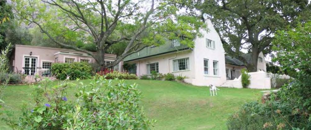
7 Photograph Date 04/05 Glenconner house from the north east Photograph Date 04/05 Glenconner house, front (north) Photograph Date 04/05 Glenconner house, north east view showing wing extension 30 October 2006 Page 7 of 11

8 Photograph Date 04/05 Glenconner house, old wall around terrace, south west. Objects - Description Visual Description U-shaped house with a hipped corrugated iron roof and Cape Dutch revival gables on the two projecting wings. Set on the bank overlooking the water meadows, it has a terrace on two sides edged with a low wall with capped posts, and with wide steps down to the garden, off centre. An old oak grows on the terrace between the two wings (the Eik in Hoek?). The house has sash windows, some with shutters, but casements on the sides. A parapeted wing on the east side appears to be a later extension. There are stone walls retaining terraces in the garden. Condition (short) Good Architectural Style Cape Dutch revival Objects - History History Possibly built early 20th C; Cape Dutch revival was a style invented by Herbert Baker that became immensely popular in the first half of the 20th century. Construction Date Early 20th C Associated Events Associated People References Objects - Assessment Significance Statement A Cape Dutch revival style house, impressively-sited on the bank overlooking the water meadows, in a lush garden. Significance Category A, E Proposed Grading 3 Vulnerablilities A = course / pattern of history B = rarity C = information potential D = characteristic of type E = aesthetic F = creative / technical G = social / cultural / spiritual H = assoc. NB person / group I = slavery 30 October 2006 Page 8 of 11

9 NHR Act Status older than 60 years (S. 34) Recommendations Further research necessary. Date of Gazette Official Grading Composite - Objects Property Name Glenconner, Jonkershoek, Stellenbosch District Composite Name Heritage Resource Name Glenconner buildings Glenconner cottage Catalogue Number 02.01/01.02 Type of Resource dwelling Photograph Date 04/04 Cottage, Glenconner Objects - Description Visual Description A small cottage with steeply-pitched corrugated iron roof, set centrally on the bank above the side road and water channels, backed by trees. It has a timber verandah in front and early 20th C steel windows with plaster surrounds. Condition (short) good Architectural Style vernacular Objects - History History Visible on 1938 aerial photo. May be a converted worker's house. Construction Date Pre-1938 Associated People Associated Events References Objects - Assessment 30 October 2006 Page 9 of 11

10 Significance Statement A simple, probably early 20th C vernacular cottage which contributes to the character of the cultural landscape. Significance Category A, E Proposed Grading 3 Vulnerablilities A = course / pattern of history B = rarity C = information potential D = characteristic of type E = aesthetic F = creative / technical G = social / cultural / spiritual H = assoc. NB person / group I = slavery NHR Act Status older than 60 years (S. 34) Recommendations Further research necessary. Date of Gazette Official Grading Composite - Objects Property Name Glenconner, Jonkershoek, Stellenbosch District Composite Name Heritage Resource Name Glenconner buildings Glenconner gateway Catalogue Number 02.01/01.03 Type of Resource Gateway Photograph Date 04/05 Gateway to river bank entrance to Glenconner Objects - Description Visual Description The main entrance to Glenconner is at a turn off from the south bank road, where there is a fine plasted gateway with capped posts (see photo). The road beyond runs westward along the bank of the Eerste River, then turns south to approach the main house via an avenue. The river bank road continues to Fybbos (02.04). Condition (short) good Architectural Style Cape vernacular Objects - History 30 October 2006 Page 10 of 11
11 History The present bridge and south bank road and riverside access to Glenconner date from the early 20th C, as does the main house; the gateway is probably contemporary with them. Construction Date Pre-1938 Associated Events Associated People References Objects - Assessment Significance Statement A simple, probably early 20th C Cape vernacular gateway which contributes to the character of the cultural landscape. Significance Category A, E Proposed Grading 3 Vulnerablilities A = course / pattern of history B = rarity C = information potential D = characteristic of type E = aesthetic F = creative / technical G = social / cultural / spiritual H = assoc. NB person / group I = slavery NHR Act Status older than 60 years (S. 34) Recommendations Further research necessary. Date of Gazette Official Grading 30 October 2006 Page 11 of 11
Heritage Survey: Stellenbosch Rural Areas
 Heritage Survey: Stellenbosch Rural Areas by and Stewart Harris - June 2004 Sub Area Name Catalogue Number 02.00 Property Name Jonkershoek Valley, Jonkershoek Farm Number n/a Heritage Resource Name Jonkershoek
East Melbourne Precinct HO2. March 2015
 East Melbourne Precinct HO2 March 2015 Local Heritage Planning Policy Review Statements of Significance Melbourne s Local Heritage Planning Policy Review project includes the preparation of statements
Architectural Inventory Form
 OAHP1403 Rev. 9/98 COLORADO CULTURAL RESOURCE SURVEY Architectural Inventory Form Official eligibility determination (OAHP use only) Date Initials Determined Eligible- NR Determined Not Eligible- NR Determined
ADDENDUM. Chain of Title. Block C, Lot 8-9. Adrian I. Velthuis and Floyd T. Grant to Lottie Thompson
 Chain of Title Block C, Lot 8-9 NLP 5175:842 October 18, 1979 NLP 4979:58 October 5, 1977 NLP 4763:448 May 11, 1977 Adrian I. Velthuis and Floyd T. Grant to Lottie Thompson Gentlemens II Properties, Inc.,
1 Gildersleeve Wood (DHR # )
") GILDERSLEEVE WOOD 1 Gildersleeve Wood (DHR # 104-5092-0012) STREET ADDRESS: 1 Gildersleeve Wood MAP & PARCEL: 11-20 PRESENT ZONING: R-1U ORIGINAL OWNER: Lindsay Family ORIGINAL USE: PRESENT USE: PRESENT
GILDERSLEEVE WOOD 1 Gildersleeve Wood (DHR # 104-5092-0012) STREET ADDRESS: 1 Gildersleeve Wood MAP & PARCEL: 11-20 PRESENT ZONING: R-1U ORIGINAL OWNER: Lindsay Family ORIGINAL USE: PRESENT USE: PRESENT
Intensive Level Historic Resources Survey 5.0 ANNOTATED LIST OF PROPERTIES
 Intensive Level Historic Resources Survey 5.0 ANNOTATED LIST OF PROPERTIES CBCA PN 05-012A May 2009 Photo Location Description 10760 Bodine Road Date: 1811 Historic addition of side block to the rear;
808 Cherry Avenue
 808 Cherry Avenue 104-0213-0059 Primary Resource Information: Single Dwelling, Stories 2.00, Style: Other, ca 1900 July 2006: This 2-story, 3-bay frame I-house features a central-front gable, a brick pier
URBAN DESIGN REPORT. Proposed Residential Development, Old Church Road, Caledon East
 Proposed Residential Development, Old Church Road, Caledon East TABLE CONTENTS: 1.0 DEVELOPMENT 1.1 Introduction-Analysis of Guiding Principles and Documents 1.2 Community Design and Architectural Design
THE BARNACLE 3485 MAIN HIGHWAY
 THE BARNACLE 3485 MAIN HIGHWAY Designation Report City of Miami REPORT OF THE CITY OF MIAMI PLANNING AND ZONING DEPARTMENT TO THE HISTORIC AND ENVIRONMENTAL PRESERVATION BOARD ON THE POTENTIAL DESIGNATION
29 Plas Derwen. Exploring Abergavenny
 29 Plas Derwen Exploring Abergavenny Cover: rhythm 2 plas derwen EXPLORING ABERGAVENNY For several years the Abergavenny and District Civic Society has been studying the streets, spaces and buildings of
11 Majors Barn. 19 Mill Street Exploring Abergavenny
 11 Majors Barn 19 Mill Street Exploring Abergavenny Cover: Mill Street from Monmouth Road 2 mill street EXPLORING ABERGAVENNY For several years the Abergavenny and District Civic Society has been studying
Date: 11 th January, From: Plaistow & Ifold Parish Neighbourhood Plan - Steering Group. Plaistow & Ifold Parish Council
 Date: 11 th January, 2017 From: Plaistow & Ifold Parish Neighbourhood Plan - Steering Group To: Plaistow & Ifold Parish Council Re: Neighbourhood Plan Report to Parish Council Meeting 17 Jan 2017 The Steering
Excavations in a Medieval Market Town: Mountsorrel, Leicestershire,
 Excavations in a Medieval Market Town: Mountsorrel, Leicestershire, by John Lucas Mountsorrel is situated 12 kms north of Leicester and forms a linear settlement straddling the A6, Leicester to Derby road.
Walk 1: Highfield, Lob Wood and The River Wharfe
 Walk 1: Highfield, Lob Wood and The River Wharfe Start: The Hen Pen Garden, Main Street, Addingham LS29 0NS, SE 077 498. Alternative Start: Near Bolton Bridge SE 071 525 (see page 6). Full walk: 4.5 miles
Society Member to Supervise the Building of James Monroe s Birthplace House Charles Belfield, a councilor of the War of 1812 Society in the
 Society Member to Supervise the Building of James Monroe s Birthplace House Charles Belfield, a councilor of the War of 1812 Society in the Commonwealth of Virginia has been designated as the supervisor
3. The Built Heritage
 3. The Built Heritage Archaeology There are individual and clusters of bronze/iron age barrows on the surrounding Wolds within the parish. The West of the Parish contains the line of the Roman Road to
Specification for Grip blocking using Peat Dams
 Technical Guidance Note 1 Specification for Grip blocking using Peat Dams 1. Introduction Moorland drains (grips) have been dug across much of the Yorkshire upland peatlands. Many of these grips have become
Survey of Littleton Down
 Survey of Littleton Down 05 November 2014 The Team: John and Jenny Barnard 1) Introduction Littleton Down (Hill Number 2911, Section 42, OS 1:50000 Map 197, OS 1:25000 Map 121, Grid Ref. SU941150) is listed
BROUGHTON GROVE FARMHOUSE, FIELD BROUGHTON. An investigation using documentary evidence.
 BROUGHTON GROVE FARMHOUSE, FIELD BROUGHTON. An investigation using documentary evidence. Location of house. Grove Farmhouse (BGF) is in the hamlet of Field which is 2 miles north of. Access is via a track
RED HOUSE FARM NORTH NEWBALD, BEVERLEY, EAST YORKSHIRE
 RED HOUSE FARM NORTH NEWBALD, BEVERLEY, EAST YORKSHIRE Tel: 01653 697820 CHARTERED SURVEYORS AUCTIONEERS VALUERS LAND & ESTATE AGENTS FINE ART & FURNITURE RED HOUSE FARM NORTH NEWBALD BEVERLEY, EAST YORKSHIRE
North York Moors National Park Authority. Director of Planning s Recommendation
 21 July 2011 List Number 11 Scarborough Borough Council (North) Parish: Hinderwell App Num. NYM/2011/0255/FL Proposal: Location: Applicant: Installation of replacement upvc windows and doors to create
ARDESTIE EARTH HOUSE HISTORIC ENVIRONMENT SCOTLAND STATEMENT OF SIGNIFICANCE. Property in Care no: 24
 Property in Care no: 24 Designations: Scheduled Monument (SM90021) Taken into State care: 1953 (Guardianship) Last reviewed: 2004 HISTORIC ENVIRONMENT SCOTLAND STATEMENT OF SIGNIFICANCE ARDESTIE EARTH
St. Patrick s Street Development Brief
 St. Patrick s Street Development Brief Bardas Chorcai Cork Corporation August 2001 Contents Introduction and background The Development Brief Area Protected and valuable buildings Urban context Objectives
Historical value The building was erected on a new site to serve a new meeting and in itself is of low historical value.
 Quaker Meeting House, Welwyn Garden City 109 Handside Lane, Welwyn Garden City, Hertfordshire, AL8 6SP National Grid Reference: TL 23149 12617 Statement of Significance As first built in 1926 to the designs
Wallace, was shaped by the existence of a stream originating in the Brooklyn foothills. This
 Post-European development of Wallace Street, named after general merchant John Howard Wallace, was shaped by the existence of a stream originating in the Brooklyn foothills. This stream ran below Wallace
MINNESOTA ARCHITECTURE - HISTORY INVENTORY FORM Property Location
 MINNESOTA ARCHITECTURE - HISTORY INVENTORY FORM ------ - Property Location -- ---- Property Name: Washington Park Address: 215 N 4th Street County: Blue Earth City/Twp: Mankato PIN: R01.09.07.461.001 Legal
Friends Meeting House, Pickering. 19 Castlegate, Pickering, YO18 7AX. National Grid Reference: SE Statement of Significance
 Friends Meeting House, Pickering 19 Castlegate, Pickering, YO18 7AX National Grid Reference: SE 79795 84336 Statement of Significance The meeting house was built in 1793; the attached burial ground was
St John s Church (Anglican)
") Heritage Item 5 St John s Church (Anglican) Location Address: 8 Lime Avenue, Barrhill Village Co-ordinates: Northing 5725414, Easting 2417496 Legal Description: Lot 7 DP 144 Blk V Corwar SD Owner: Church
Heritage Item 5 St John s Church (Anglican) Location Address: 8 Lime Avenue, Barrhill Village Co-ordinates: Northing 5725414, Easting 2417496 Legal Description: Lot 7 DP 144 Blk V Corwar SD Owner: Church
BISHOPSTONE CIRCULAR WALK
 BISHOPSTONE CIRCULAR WALK 4½ miles (7¼ km) - allow 2 hours (see maps on final pages) Introduction This walk is within the North Wessex Downs Area of Outstanding Natural Beauty and starts from the small,
Section II. Islesboro 2030 Guiding Statement
 Section II. Islesboro 2030 Guiding Statement Section II. Islesboro 2030 Guiding Statement 6 A. CHARACTER OF THE COMMUNITY Islesboro is an island community with unsurpassed natural beauty. Its history is
STOCKBRIDGE RAILWAY STATION
 STOCKBRIDGE RAILWAY STATION By R. WARMINGTON A CANAL was opened between Redbridge and Andover, following the valleys of the Rivers Test and Anton in 1794. The financial results of this undertaking disappointed
301 7½ Street SW
 301 7½ Street SW 104-0213-0072 Primary Resource Information: Single Dwelling, Stories 2.00, Style: Other, ca 1890 July 2006: This late-19th-century, 3-bay, 2-story, hip-roofed frame I-house features projecting
Hunter Water S170 Register
 SHI No.: 3630112 Location Name: 800 Salisbury Rd, Munni NSW 2420 Other ID nos HW ID: 130. Description: The house is set on a buff over looking the creek The house is built in the colonial style, single
4. Bronze Age Ballybrowney, County Cork Eamonn Cotter
 4. Bronze Age Ballybrowney, County Cork Eamonn Cotter Illus. 1 Location map of the excavated features at Ballybrowney Lower (Archaeological Consultancy Services Ltd, based on the Ordnance Survey Ireland
North & West Melbourne Precinct HO3. March 2015
 North & West Melbourne Precinct HO3 March 2015 Local Heritage Planning Policy Review Statements of Significance Melbourne s Local Heritage Planning Policy Review project includes the preparation of statements
Dufferin Jog Elimination Project
 Project Project Status Update November 14 2007 Project History Planning Alternatives Criteria Measured Project Benefits Structural Configurations Considered Structural Design Considerations The Preferred
OUTSTANDING AND UNIQUE DEVELOPMENT OPPORTUNITY GELT HALL, CASTLE CARROCK, CUMBRIA
 OUTSTANDING AND UNIQUE DEVELOPMENT OPPORTUNITY GELT HALL, CASTLE CARROCK, CUMBRIA OUTSTANDING AND UNIQUE DEVELOPMENT OPPORTUNITY, GELT HALL, CASTLE CARROCK, CUMBRIA Background Savills are delighted to
A meeting house built on a new site in 1961 to the design of Joseph Konrad. The building is of low heritage significance.
 Friends Meeting House, Beverley Quaker Lane, (off Woodlands), Beverley, HU17 8BY National Grid Reference: TA 02930 39656 Statement of Significance A meeting house built on a new site in 1961 to the design
A21 TONBRIDGE TO PEMBURY DUALLING. Statement of Case
 A21 TONBRIDGE TO PEMBURY DUALLING Statement of Case In Respect of Applications for the Demolition of Listed Buildings Under the Provisions of the Planning (Listed Buildings and Conservation Areas) Act
Felden Orchard I Bulstrode Lane I Felden. aitchisons.co.uk TOWN & COUNTRY
 Felden Orchard I Bulstrode Lane I Felden aitchisons.co.uk TOWN & COUNTRY Felden Orchard I Bulstrode Lane I Felden HP3 0BP A Home with Immense Character Felden is a delightful hamlet surrounded by rolling
Commonwealth of Massachusetts Massachusetts Historical Commission 220 Morrissey Boulevard, Boston, Massachusetts
 Inventory No: Historic Name: Common Name: Address: HRV.165 Blood, Joseph House Farnsworth, Jonathan - Beaman, Jonathan House 74 Poor Farm Rd City/Town: Village/Neighborhood: Local No: 9-17 Year Constructed:
Greenfield Lodge Farm, Strixton, Northamptonshire
 Greenfield Lodge Farm, Strixton, Northamptonshire Greenfield Lodge Farm Strixton, Northamptonshire NN29 7PB An exceptionally well presented arable farm of about 1,035.05 acres (418.88 ha) predominantly
Friends Meeting House, Warwick. 39 High Street, Warwick, CV34 4AX. National Grid Reference: SP Statement of Significance
 Friends Meeting House, Warwick 39 High Street, Warwick, CV34 4AX National Grid Reference: SP 28071 64737 Statement of Significance Warwick Meeting House has exceptional heritage significance as a fine
5.17 STRANDFONTEIN (permanent population: + 110) (IDP )
 (IDP )") page 305 5.17 STRANDFONTEIN (permanent population: + 110) (IDP 2012-2017) 5.17.1 SPATIAL ANALYSIS, see Figures 5.17.1 Sub-regional location On the West Coast, approximately 8kms north of Doringbaai and
page 305 5.17 STRANDFONTEIN (permanent population: + 110) (IDP 2012-2017) 5.17.1 SPATIAL ANALYSIS, see Figures 5.17.1 Sub-regional location On the West Coast, approximately 8kms north of Doringbaai and
Reservoir Tin workings
 The workings are quite over-grown and covered in moss, suggesting that they date to the earliest period of mining. This is supported by the fact that their head race was cut off by the reservoir (D49/47)
Change dormers and main entry on the river side of the house. Site: 43 Riverbank Road, Block 10 Lot 3
 City of Burlington Historic Preservation Commission Meeting Minutes: December 2, 2015 The City of Burlington Historic Preservation Commission held its regular monthly meeting on Wednesday, December 2,
Retreat Farm. Grimley Worcestershire
 Retreat Farm Grimley Worcestershire Retreat Farm Grimley Worcestershire A fine equestrian farm with a Grade II Listed farmhouse and cottage, well fenced paddocks, fishing pools and river frontage For
MEDIA ADVISORY. FOR IMMEDIATE RELEASE November 12, 2012
 MEDIA ADVISORY FOR IMMEDIATE RELEASE November 12, 2012 Niagara-on-the-Lake On Monday, November 19, 2012, the Lord Mayor and members of the Town s Municipal Heritage Committee and War of 1812 Bicentennial
Pemsey Farm Brabourne Lees Ashford. equestrian property Agents
 Pemsey Farm Brabourne Lees Ashford equestrian property Agents Equestrian Property homes for horses and riders www.hobbsparker.co.uk Pemsey Farm Brabourne Lees, Ashford, Kent TN25 6QB A small grass farm
HARTPURY MILL HARTPURY GLOUCESTER
 HARTPURY MILL HARTPURY GLOUCESTER HARTPURY MILL HARTPURY GL19 An idyllic ring fenced former farmstead and water mill with equestrian facilities set in approximately 43 acres Reception hall Drawing room
 Page 1 Original Update HISTORICAL STRUCTURE FORM FLORIDA MASTER SITE FILE Consult Guide To Historical Structure Forms for detailed instructions Site # 8OR9844 Recorder # 26 Recorder Date 2/20/08 Site Name
DESIGNATION REPORT KENNEDY-BAKER-WALKER-SHERRILL HOUSE (1849) 9320 KINGSTON PIKE (CLT ) KNOXVILLE, TENNESSEE July 12, 2007
 9320 KINGSTON PIKE (CLT ) KNOXVILLE, TENNESSEE July 12, 2007") DESIGNATION REPORT KENNEDY-BAKER-WALKER-SHERRILL HOUSE (1849) 9320 KINGSTON PIKE (CLT 132-027) KNOXVILLE, TENNESSEE July 12, 2007 Description The Kennedy-Baker-Walker-Sherrill House is located on the south
DESIGNATION REPORT KENNEDY-BAKER-WALKER-SHERRILL HOUSE (1849) 9320 KINGSTON PIKE (CLT 132-027) KNOXVILLE, TENNESSEE July 12, 2007 Description The Kennedy-Baker-Walker-Sherrill House is located on the south
Lodsbridge Mill, Selham, West Sussex
 Lodsbridge Mill, Selham, West Sussex A small estate with an 18th Century former watermill on the banks of the River Rother, separate 17th Century cottage, spa complex and stabling, total 18.73 acres (7.58
A walk around old Ardersier
 A walk around old Ardersier Ardersier Local History Group 2014 Welcome to our Ardersier village walk We hope you enjoy your tour and that the weather is dry! Allow an hour for a leisurely stroll: the
Plaquing Nomination for Thornleigh Quarry & Zig Zag Railway Page 2 LOCALITY PLAN 3 SITE MAP 4 PLAQUE NOMINATION FORM 6
 Plaquing Nomination for Thornleigh Quarry & Zig Zag Railway Page 2 Contents INTRODUCTION 3 LOCALITY PLAN 3 SITE MAP 4 PLAQUE NOMINATION FORM 6 PLAQUING NOMINATION ASSESSMENT FORM 7 1 BASIC DATA 7 2 ASSESSMENT
Attachment G STREAM IMPACTS. Ridge Road Extension Alternatives Analysis
 Attachment G STREAM IMPACTS for: Ridge Road Extension Alternatives Analysis PREPARED FOR: Pasco County Engineering Services Department PREPARED BY: NV5, INC. 6989 E. FOWLER AVENUE TAMPA, FLORIDA 33617
Westbury House, Westbury Sub Mendip, Somerset. BA5 1HA 1,400,000
 Westbury House, Westbury Sub Mendip, Somerset. BA5 1HA 1,400,000 Period village property set within extensive formal gardens, extending over 3 acres, Southerly views over open countryside towards Westbury
STATE OF IOWA. Historical and Architectural Survey for 2008 Flood Projects in Vinton, Benton County
 STATE OF IOWA CHESTER J. CULVER GOVERNOR PATTY JUDGE LT. GOVERNOR DEPARTMENT OF PUBLIC DEFENSE IOWA HOMELAND SECURITY AND EMERGENCY MANAGEMENT DIVISION DAVID L. MILLER, ADMINISTRATOR Historical and Architectural
APPENDIX K: BUILT HERITAGE AND CULTURAL HERITAGE LANDSCAPES
 APPENDIX K: BUILT HERITAGE AND CULTURAL HERITAGE LANDSCAPES TABLE 1: Built Resources (BHR) and Cultural Heritage Landscapes (CHL) Within and Adjacent to the West Whitby Secondary Plan Area Site # 1. CHL
SURVEY OF PUBLIC HOUSES WESTON TURVILLE
 BUCKINGHAMSHIRE ARCHAEOLOGICAL SOCIETY HISTORIC BUILDINGS GROUP SURVEY OF PUBLIC HOUSES IN THE PARISH OF WESTON TURVILLE BUCKINGHAMSHIRE A record of extant buildings that are currently or were formerly
HYDROLOGY OF GLACIAL LAKES, FORT SISSETON AREA
 PROC. S.D. ACAD. SCI., VOL. 77 (1998) 59 HYDROLOGY OF GLACIAL LAKES, FORT SISSETON AREA Perry H. Rahn Department of Geology & Geological Engineering South Dakota School of Mines and Technology Rapid City,
CULTURAL HERITAGE RESOURCES IMPACT ASSESSMENT ON MALOKONG HILL
 CULTURAL HERITAGE RESOURCES IMPACT ASSESSMENT ON MALOKONG HILL AFRICAN HERITAGE CONSULTANTS CC 2001/077745/23 Tel/fax: (012) 567 6046 Cell: 082 498 0673 E-mail: udo.heritage@absamail.co.za DR. UDO S KÜSEL
LOGAN BECK FARM. Broughton-in-Furness, Cumbria, LA20 6EU
 LOGAN BECK FARM Broughton-in-Furness, Cumbria, LA20 6EU A delightful small farm on the westerley slopes of the Duddon Valley. Stunning location. Listed farmhouse. Excellent range of farm buildings. Sound
Claro Community Archaeology Group
 Site Record Form Item Number Claro Community Archaeology Group 60940161 Date Initials Inspected Access Visibility NGR Centre 434851 458431 NGR Linear Item Description HOUSE Site Data Roundell's Manor History
MAP AMENDMENT/HEIGHT MAP AMENDMENT SUMMARY. Three stories above River Street Two stories above River Street
 MPC STAFF REPORT TEXT AMENDMENT Historic District Height Map MAP AMENDMENT/HEIGHT MAP AMENDMENT SUMMARY Report Status Initial Report- Petitioner, Property Owner, Agent Information SRD, LLC d/b/a The Kessler
NEWBORO AND PORTLAND HARBOUR REDVELOPMENT PLANS
 INTRODUCTION The Municipal docks in both Newboro and Portland were transferred to the Township of Rideau Lakes by Parks Canada in 2002. Little has been done to improve the docks physical condition or role
FOUNDATIONS OF ARCHAEOLOGY A WALK IN VERNDITCH CHASE
 FOUNDATIONS OF ARCHAEOLOGY A WALK IN VERNDITCH CHASE 1. A Tale of two Long Barrows Long barrows were constructed as earthen or drystone mounds with flanking ditches and acted as funerary monuments during
Middle Barn Farm PULBOROUGH, WEST SUSSEX
 Middle Barn Farm PULBOROUGH, WEST SUSSEX Middle Barn Farm PULBOROUGH, WEST SUSSEX A large Grade II Listed barn conversion with secondary accommodation on the fringes of Pulborough enjoying a fantastic
DRAFT MADE AVAILABLE FOR PUBLIC COMMENT HERITAGE STATEMENT PROVIDED IN RESPECT OF AN APPLICATION IN TERMS OF SECTION 34(1)
") DRAFT MADE AVAILABLE FOR PUBLIC COMMENT HERITAGE STATEMENT PROVIDED IN RESPECT OF AN APPLICATION IN TERMS OF SECTION 34(1) - 146 Kloof Road, Bantry Bay, Cape Town (Erven 117RE & 619, Bantry Bay) PREPARED
DRAFT MADE AVAILABLE FOR PUBLIC COMMENT HERITAGE STATEMENT PROVIDED IN RESPECT OF AN APPLICATION IN TERMS OF SECTION 34(1) - 146 Kloof Road, Bantry Bay, Cape Town (Erven 117RE & 619, Bantry Bay) PREPARED
ARCHAEOLOGICAL MONITORING OF THE ASHBY STREET DRAINAGE PROJECT, SAN ANTONIO, BEXAR COUNTY, TEXAS
 ARCHAEOLOGICAL MONITORING OF THE ASHBY STREET DRAINAGE PROJECT, SAN ANTONIO, BEXAR COUNTY, TEXAS Anne A. Fox and I. Waynne Cox / Center for Archaeological Research The University of Texas at San Antonio
Hay Wood, Rowington and Baddesley Clinton - Warwickshire
 Hay Wood, Rowington and Baddesley Clinton - Warwickshire Starts at Lay-by alongside Hay Wood 2 hours 30 minutes 5.5miles 8.8km Leisurely ID: 0.683 Developed by: John Clift Checked by: Andy Page www.ramblersroutes.org
ATTACHMENTS : LANDSCAPE MAPS AND PHOTO ESSAY
 DRURY STRUCTURE PLAN : BACKGROUND INVESTIGATIONS AND VISUAL ASSESSMENT ATTACHMENTS : MAPS AND PHOTO ESSAY Opus International Consultants Ltd Landscape Architecture and Urban Design Level 3 The Westhaven
2.0 Historical Summary
 2.0 Historical Summary 2.1 Introduction The following historical analysis contributes to the assessment of cultural significance of the site at 753 755 Darling Street Rozelle. The information is drawn
Dubai s most prestigious freehold neighbourhood
 Dubai s most prestigious freehold neighbourhood Dubai A dynamic city This dynamic city is one of the most exciting and attractive investment arenas in the world. Today, the name Dubai is synonymous with
HB/10/06/003 Camus House, 46 Lisky Rd, Strabane. Foyle Valley
 Asset Ref No. Heritage Type House, Gates, Outbuildings, Walling Including Around Flax Drying Green. Built Post-Medieval house Location OS 6-inch map sheet Townland Parish LCA Foyle Valley ITM Coordinates
The selector s hut at Camp Mountain
 The selector s hut at Camp Mountain A report on its conservation, repair and maintenance, for the Institute for Sustainable Resources, Queensland University of Technology Peter Marquis-Kyle conservation
at: Accessed May 4, 2011.
 3.11 SAFETY 3.11.1 Background and Methodology As with other forms of transportation, there is risk associated with aviation activities. This section focuses on risk to those on the ground near airports.
HYDRAULIC DESIGN OF THE TOURISTIC BERTHING IN ASWAN CITY
 HYDRAULIC DESIGN OF THE TOURISTIC BERTHING IN ASWAN CITY Dr. Hossam El-Sersawy Researcher, Nile Research Institute (NRI), National Water Research Center (NWRC), Egypt E-mail: h_sersawy@hotmail.com Dr.
Address 347 Whitney Street. East elevation, camera facing southwest.
 FORM B BUILDING Assessor s Number USGS Quad Area(s) Form Number MASSACHUSETTS HISTORICAL COMMISSION MASSACHUSETTS ARCHIVES BUILDING 220 MORRISSEY BOULEVARD BOSTON, MASSACHUSETTS 02125 Town Northborough
Figure San Dimas Bonita at San Dimas Avenue (view looking west)
") The adjoining neighborhood has an eclectic assortment of building types and uses, including: the historically significant but not architecturally or visually noteworthy San Dimas Lemon Association Packing
The adjoining neighborhood has an eclectic assortment of building types and uses, including: the historically significant but not architecturally or visually noteworthy San Dimas Lemon Association Packing
Friends Meeting House, Hitchin. 1 Paynes Park, Hitchin, Hertfordshire, SG5 1EH. National Grid Reference: TL Statement of Significance
 Friends Meeting House, Hitchin 1 Paynes Park, Hitchin, Hertfordshire, SG5 1EH National Grid Reference: TL 18282 29279 Statement of Significance A meeting house of 1957 designed by Paul V. Mauger and erected
The meeting house is a converted Plymouth Brethren Chapel which originally was two cottages. It has medium significance.
 Quaker Meeting House, Ashburton Foales Court, off North Street, Ashburton, Devon, TQ13 7QE National Grid Reference: SX 75574 69951 Statement of Significance The meeting house is a converted Plymouth Brethren
APPENDIX A HISTORIC RESOURCES INVENTORY FEATURE LOCATION OWNERSHIP DESCRIPTION
 APPENDIX A HISTORIC RESOURCES INVENTORY FEATURE LOCATION OWNERSHIP DESCRIPTION Map 1 - Sea Ranch North Del Mar West of Highway 1 This gable roof board and batten in The Sea Ranch cottage is one of the
Bainbridge Ranch Cape Girardeau - Missouri Listed at $9,000,
 Bainbridge Ranch Cape Girardeau - Missouri Listed at $9,000,000.00 -------------------------------------------------------------------------------- Bainbridge Ranch (+/- 1595 acres) is a unique and impressive
Why Is the Tower Here?
 Red Tower Why Is the Tower Here? The Romans only walled their government and civilian areas, ie. around modern Minster and Micklegate. During the Viking period and later, the walls were rebuilt and extended,
Friends Meeting House, Leek. Overton Bank, Leek, ST13 5ES. National Grid Reference: SJ Statement of Significance
 Friends Meeting House, Leek Overton Bank, Leek, ST13 5ES National Grid Reference: SJ 98200 56563 Statement of Significance The meeting house was purpose-built in 1697 and has high heritage value, as an
HISTORICAL AND SOCIAL SIGNIFICANCE PHOTOGRAPH: M.VAIR-PIOVA, 5/12/2014
 DISTRICT PLAN LISTED HERITAGE PLACE HERITAGE ASSESSMENT STATEMENT OF SIGNIFICANCE HERITAGE ITEM NUMBER 608 MILL ISLAND AND SETTING AVON RIVER BETWEEN HEREFORD-WORCESTER/71 HEREFORD STREET, 110 CAMBRIDGE
Doncaster Market Place Conservation Area
 Doncaster Market Place Conservation Area Review December 2014 www.doncaster.gov.uk/conservationareas Doncaster Market Place Conservation Area Review Since the appraisal undertaken in March 2007, the general
CHALMINGTON MANOR. Chalmington Dorchester Dorset
 CHALMINGTON MANOR Chalmington Dorchester Dorset CHALMINGTON MANOR Chalmington Dorchester Dorset Cattistock 3 miles, Evershot 4 miles, Beaminster 9.5 miles, Dorchester 10.5 miles, Yeovil Junction 11 miles
SUMMER VILLAGE OF SILVER SANDS. Municipal Development Plan
 SUMMER VILLAGE OF SILVER SANDS Municipal Development Plan Bylaw 253-2014 Adopted August 22, 2014 Summer Village of Silver Sands Municipal Development Plan Bylaw No. 253-2014 Page 2 1 INTRODUCTION 1.1 SETTING
CARLUNGIE EARTH HOUSE
 Property in Care (PIC) ID: PIC015 Designations: Scheduled Monument (SM90059) Taken into State care: 1953 (Guardianship) Last reviewed: 2004 HISTORIC ENVIRONMENT SCOTLAND STATEMENT OF SIGNIFICANCE CARLUNGIE
Chapter 7 Geography and the Early Settlement of Egypt, Kush, and Canaan
 Chapter 7 Geography and the Early Settlement of Egypt, Kush, and Canaan How did geography affect early settlement in Egypt, Kush, and Canaan? Section 7.1 - Introduction RF/NASA//Corbis This satellite photograph
CENTER PIVOT TRACK MANAGEMENT OPTIONS
 Proceedings of the 28th Annual Central Plains Irrigation Conference, Kearney, Nebraska, February 23-24, 2016 Available from CPIA, 760 N. Thompson, Colby, Kansas CENTER PIVOT TRACK MANAGEMENT OPTIONS Steven
Maps and satellite images of the Cape Floral Region Protected Areas (World Heritage Site)
") Maps and Satellite Images of the Cape Floral Region Protected Areas Location of the eight original components of the Cape Floral Region Protected Areas World Heritage Site as inscribed in 2004 (from: www.africannaturalheritage.org)
Maps and Satellite Images of the Cape Floral Region Protected Areas Location of the eight original components of the Cape Floral Region Protected Areas World Heritage Site as inscribed in 2004 (from: www.africannaturalheritage.org)
Type of Building. By-law
 1 2 Architectural and General Context - Two storey wood-frame residence with vinyl clad exterior. - Property was original purchased by William Newton, a local physician. - Hip roof. - Windows have shutters.
BUCK POINT RANCH. Aspen Associates Realty
 BUCK POINT RANCH Aspen Associates Realty www.aspenassociatesrealty.com 970.544.5800 WELCOME TO Buck Point Ranch is a 960± acre property located in one of the last pristine valleys in close proximity to
1 INFORMATION REQUIREMENTS
 1 INFORMATION REQUIREMENTS 1.1 BACKGROUND 2 1.2 WHAT IS THE DISTRICT PLAN 3 1.3 DISTRICT PLAN STRUCTURE 4 1.4 HOW TO USE THE DISTRICT PLAN 5 1.5 STRATEGIC FRAMEWORK 6 Whanganui District Plan (15 January
Glacial Geomorphology Exercise
 James Madison University Field Course in western Ireland Glacial Geomorphology Exercise 3-day road log (abbreviated) Striations Large kame terrace Cirque with moraines Kame delta Striations Eskers Raised
K Fellfarers Archives a Brief Summary Last update: MF. 6 March 2015
 K Fellfarers Archives a Brief Summary Last update: MF. 6 March 2015 Files listed as deposit are retained in the ownership of K Fellfarers. Those listed as gift are in the ownership of Cumbria County Council.
RIO VISTA MUNICIPAL AIRPORT
 DRAINAGE TECHNICAL MEMORANDUM RIO VISTA MUNICIPAL AIRPORT RIO VISTA, CALIFORNIA Prepared for: City of Rio Vista 1 Main Street Rio Vista, CA 94571 (707) 374-5337 Prepared by: August 2012 Copyright 2012