Simcoe County Accessible Trails. March 25, 2015
|
|
|
- Ophelia Brooks
- 5 years ago
- Views:
Transcription
1 Simcoe County Accessible Trails March 25, 2015

2 Agenda 9:30 9:40 Introduction 9:40 10:00 Geordie Gibbon, Accessibility Directorate 10:00 10:30 Patrick Connor, OTC 10:30 10:55 Jay Cranstone, MMM Group 10:55 11:10 BREAK 11:10 11:30 Ian Buchanan, York Region 11:30 12:30 Panel Q&A
3 Accessibility in Ontario: Design of Public Spaces Simcoe County March 25, 2015 Ministry of Economic Development, Employment and Infrastructure
4 Why Accessibility? The Numbers 15.5% People with disabilities About 1.85 million people in Ontario have disabilities Seniors aged 65+ could more than double to 4.1 million by 2036 By 2017, more seniors than children aged 14 and under 4


5 About the IASR Why these standards? Design of Public Spaces is about making public spaces more accessible. Employment is about making accessibility a regular part of finding, hiring and supporting employees with disabilities. Information and communications is about helping people with disabilities access information and communications that many of us rely on every day. Transportation is about making it easier for everyone to travel in Ontario. 5

6 Accessible Public Spaces Why are they important? Leisure contributes to overall health and happiness 85% of Ontarians live within walking distance of a park, playground or green space Parks are places to go for recreation AND places where just being there is recreation Recreation and parks are important to fostering healthy children Parks and Recreation Ontario 6
7 Why Accessibility? Drawing visitors to Ontario 10% Ontario s land mass covered by parks Ontario has over 9 million hectares of parks and protected areas About 10 million people use our provincial parks system every year Accessibility could bring an increase in tourism spending of $400 million to $1.6 billion 3% 7% increase in visits 7
8 Design of Public Spaces 7 sections Outdoor Public Use Eating Areas Outdoor Play Spaces Exterior Paths of Travel Recreational Trails and Beach Access Routes Design of Public Spaces Standard Accessible Parking Maintenance Obtaining Services 8
9 Highlights of Requirements Who needs to comply? Requirements apply to public, private and not-for-profit organizations in Ontario Schedule for compliance: Government of Ontario, Legislative Assembly: January 1, 2015 Public sector organizations (e.g. municipalities, hospitals, schools): January 1, 2016 Large private businesses/non-profit organizations (50+ employees): January 1, 2017 Small private businesses/non-profit organizations (1-49 employees): January 1, 2018 Go-forward basis organizations are not required to renovate or retrofit existing spaces (i.e. no unplanned changes) Flexibility built into requirements allows for organizations to consider local circumstances and/or needs when implementing Implementation of requirements will result in a minimum level of accessibility across all Ontario communities 9
10 Design of Public Spaces Consultation The regulation contains specific requirements for public consultation in the following areas: Recreational trails slope, need & location, location of rest, passing and viewing areas Outdoor play spaces Exterior paths design and placement of rest areas On- street parking need, location and design of accessible on-street parking The regulation prescribes who you have to consult People with disabilities The public Accessibility Advisory Committee 10


11 Guides to Accessible Public Engagement Step by step guidance on: designing accessible public engagement processes organizing and running meetings of all sizes that are accessible to all participants 11


12 Accessibility Standard for the Design of Public Spaces Recreational trails Public pedestrian trails intended for recreational and leisure purposes Does not apply to certain types, like wilderness trails, backcountry trails and portage routes 12


13 For pedestrian use Provide access to public beaches from: off-street parking facilities recreational trails exterior paths of travel amenities Beach access routes can be permanent or temporary Accessibility Standard for the Design of Public Spaces Beach access routes 13


14 Accessibility Standard for the Design of Public Spaces Outdoor public-use eating areas People with disabilities will be able to use accessible tables in a variety of public spaces, such as: hospitals university campuses parks Requirements address: number of tables design of eating areas surface area 14


15 More integrated play experiences for children and caregivers. Accessibility Standard for the Design of Public Spaces Outdoor play spaces 15

16 Accessibility Standard for the Design of Public Spaces Exterior paths of travel Sidewalks and walkways that link us between places to work, travel, shop and play Includes requirements for: Ramps Stairs Curb ramps Depressed curbs Accessible pedestrian signals Rest areas 16

 Type B")
17 Accessibility Standard for the Design of Public Spaces Accessible parking More off-street and on-street accessible parking spaces Minimum numbers and size of spaces Access aisles and signage requirements Type A (wider) Type B (standard) 17


18 Accessible fixed queuing guides Accessibility Standard for the Design of Public Spaces Service-related elements Accessible waiting areas Accessible service counters 18


19 Document routine maintenance procedures for accessibility features, such as: stairs sidewalks trails Accessibility Standard for the Design of Public Spaces Maintenance 19
20 Exceptions: Design of Public Spaces Standard The Integrated Accessibility Standards Regulation includes a number of exceptions, including allowances for practicability. Other considerations could include minimizing impacts on wildlife, the environment and cultural heritage Organizations ultimately determine if their circumstances require an exception, but they must be able to prove that it was necessary or provide a rationale upon request The standard does not prescribe how to document the rationale Transition clause excludes contracts entered into before December 31,


21 Compliance and Enforcement Audit Return to Compliance Plan May include organizations that: Did not file Are in progress Answered no to some or all report questions Said they are in full compliance Return to Compliance Plan used to help non-compliant organizations fully comply and sets a deadline Enforcement Fines, Court Intervention May include: Notices of Proposed Order Inspections Director s Order, with penalty ($200 - $15,000) Failure to respond to a Director s Order within 30 days $50,000 per day for an individual $100,000 per day for a corporation 21
22 EnAbling Change partnerships Ontario Trails Council This project will ensure organizations providing trail management, trail development, and trail use are aware of AODA information and communications requirements. 22


23 GAATES produced a DOPS guide, e-learning modules and webinars tailored for Ontario s architects, landscape architects, interior designers, engineers and planners Global Alliance on Accessible Technologies and Environments (GAATES) 23

24 Parks and Recreation Ontario project Parks and Recreation Ontario (PRO) has produced a webinar and companion resource guidebook to help prepare owners and operators of recreational facilities, playgrounds, parks and trails for the requirements of the Design of Public Spaces Standard. 24


25 Naturally Accessible: Discovering Ontario s Land Trusts A project with the Ontario Land Trust Alliance to discover best practices to make land trust properties and programs more accessible 25

26 26

27 AODA Compliance Wizard Answer a few questions about your organization, and the Wizard will give you a personalized summary of what you have to do to comply Free and user-friendly The Wizard can be found at 27
 Toll-Free: 1-866-515-2025 TTY: 416-325-3408 /")
28 For more information... ontario.ca/accesson AODA Contact Centre (ServiceOntario) Toll-Free: TTY: / Fax: AccessOntario 28
29 Accessible Trails Presentation Simcoe County Prepared and Presented by Patrick Connor CAE March 25, 2015
30 Management of Trails in Ontario Ontario Trails Strategy is the high level over arching policy that acknowledges: 51 challenges for trails A process to support improvement for trails right to the local level Reduce Conflict Improve regulation Support Planning with Funding Desire A world class system of Trails
31 Purpose of Session To provide a context for accessible trail planning and management practice To provide some detail on accessible trails Position accessible trails communication in Ontario To provide detail on what has worked to organize trail managers and users to address accessible trail needs.
32 And a trail Is? A marked or beaten path or route through natural or urban areas, and lands in-between facilitating motorized or non-motorized recreation on single or shared use tracks, over natural or built areas.» Ontario Recreational Framework, September 2011
33 What are we managing? Recognize trail(s) as outdoor recreational infrastructure A complex operating environment Multiple uses or Single or Shared Land Management Authority Species at Risk Greater Public Accessibility
34 Tools of Management Recreational Trails Hours of operation Controlled Access Conduct Rules Training Development and Education Program Emergency response Community Involvement Funding Governance Staff
35 Planning to ensure good Management Recreational Trails Controlled Access managed, posted and published Conduct Rules policy and regulation, signage Training developmental to elite for users Development and Education Program for users Emergency response community supported, system(s) supported Community Involvement fundraising, clubs, associations Funding government, grants, fundraising Governance Boards, Committees, Councils, Ministries Staff trained, available, funded, professional development Hours of operation posted and communicated
36 Trail Facts Good management means understanding what you are trying to manage Inventory Location Investment Use Development Management Process The Regional Trail Committee
37 Trail Facts Good management for trails with community includes mapping of routes

38
39 Trail Facts Good management for trails with community includes location of trails

40
41 Trail Facts Good management for trails with community includes lists of accessible trails

42
43 Trail Facts Good management for trails with community includes identifiers for accessible trails information.
44

45 Website Accessibility Facts Good management for trails with community includes identifiers for accessible trails information for the people that may need to use it.

46
47 Website and Communication Accessibility Resources OTC Guide for Trails Organizations Accessible Communications Web Site Checkers WCAG compatible? RDG Access Ability Best Practices Handbook CNIB Web and Digital Accessibility and Accessibility Resources Ontario Trails Trails for All-Ontarians-Design of Trails GAATES - The Illustrated Technical Guide to the Accessibility Standard for the Design of Public Spaces Pathways to Recreation: Learning about Ontario s Accessibility Standard for the Design of Public Spaces Accessible Customer Service Standard Integrated Accessibility Standards Regulation

48 Simcoe County Accessible Trails Jay Cranstone, B.Sc., MLA, OALA, CSLA Senior Landscape Architect Associate March 25, 2015 Applying the Accessibility Standards for the Built Environment to Trails

49 Outline Definitions Design Requirements Consultation Signage Putting It Into Practice Useful Resources Applying the Built Environment Standard to Trails, Simcoe County March 25, 2015 Slide 49

50 Definitions Applying the Built Environment Standard to Trails, Simcoe County March 25, 2015 Slide 50
51 Definitions Recreational Trail Public pedestrian trails Intended for recreational and leisure uses Beach Access Route Public pedestrian use Access to an area of a beach that is intended for recreational use by the public Exterior Path of Travel Outdoor sidewalks or walkways for pedestrian travel Serve a functional purpose, not a recreational experience Specificity of Design Criteria Applying the Built Environment Standard to Trails, Simcoe County March 25, 2015 Slide 51


52 Recreational Trail


53 Beach Access Route


54 Exterior Path of Travel

55 Minimum 2.1 m Clearing Height Recreational Trails - Design Sections 80.6 to 80.9 Technical requirements for Recreational Trails Minimum trail clear width of 1.0 m Minimum trail head room clearance of 2.1 m Minimum 1.0 m Clearing Width Applying the Built Environment Standard to Trails, Simcoe County March 25, 2015 Slide 55

56 Recreational Trails - Design Surface Firm and stable trail surface Resists permanent indentation Concrete and Asphalt Wood (e.g. boardwalk) Granular Surfaces Packed Earth and Soil Cement Wood chips Applying the Built Environment Standard to Trails, Simcoe County March 25, 2015 Slide 56


57 Recreational Trails - Design Openings in the Surface Does not allow passage of an object greater than 20 mm in diameter Oriented perpendicular to the path of travel Edge protection when next to water or a drop off Applying the Built Environment Standard to Trails, Simcoe County March 25, 2015 Slide 57


58 Recreational Trails - Design Entrances Where gates, bollards or some other form of trail entrance is used Opening between 850 mm and 1000 mm to allow passage for mobility devices Applying the Built Environment Standard to Trails, Simcoe County March 25, 2015 Slide 58
, or historic places marked or commemorated under the Historic Sites and Monuments Act")
59 Recreational Trails - Design Exceptions The requirements, or some of them, would likely affect the cultural heritage value or interest of a property identified, designated or protected under the Ontario Heritage Act, places designated as National Historic Sites under the Canada National Parks Act (Canada), or historic places marked or commemorated under the Historic Sites and Monuments Act (Canada). Applying the Built Environment Standard to Trails, Simcoe County March 25, 2015 Slide 59
 World Heritage sites.")
60 Recreational Trails - Design Exceptions Indirectly or directly damage, the cultural heritage or natural heritage resources on a property included in the list of United Nations Educational, Scientific and Cultural Organization s (UNESCO) World Heritage sites. Significant risk of adversely affecting (directly or indirectly) water, fish, wildlife, plants, invertebrates, species at risk, ecological integrity or natural heritage values Applying the Built Environment Standard to Trails, Simcoe County March 25, 2015 Slide 60
61 Recreational Trails - Design Exceptions It is not practicable to comply with the requirements Existing physical or site constraints prohibit modification or addition of elements, spaces or features needed to meet accessibility requirements Applying the Built Environment Standard to Trails, Simcoe County March 25, 2015 Slide 61

62 Recreational Trails - Consultation Consult With the public and persons with disabilities Representatives of the local Accessibility Advisory Committee Early in the process to understand the opportunities and challenges To determine if the trail can be designed to be accessible At key milestones during the detailed design process When developing signage Applying the Built Environment Standard to Trails, Simcoe County March 25, 2015 Slide 62
63 Recreational Trails - Signage Trail head signage - easily understood and detectable by users of all abilities, Trail length Type of surface Average and minimum trail width Average and maximum running slope and cross slope, and the Location of amenities Users can make an informed personal decision about which trails they will use. Applying the Built Environment Standard to Trails, Simcoe County March 25, 2015 Slide 63
 Pictograms where possible, appropriate High tonal contrast between text and background Source: York Region Applying the Built")
64 Recreational Trails - Signage Sans serif fonts (e.g. S vs. S) Pictograms where possible, appropriate High tonal contrast between text and background Source: York Region Applying the Built Environment Standard to Trails, Simcoe County March 25, 2015 Slide 64

65 Recreational Trails - Signage Contrast : Guideline a minimum 70% based on Light Reflectance Value (LRV) LRV measures the amount of visible and usable light that reflects from or absorbs into a painted surface. percentage of light a paint color reflects. Values from 0 to 100 absolute black = 0 (absorbing all light) pure white = 100 (reflecting all light) Contrast = ( B1 - B2 ) x 100 / B1 B1 = LRV of the lighter area B2 = LRV of the darker area Source: York Region Applying the Built Environment Standard to Trails, Simcoe County March 25, 2015 Slide 65

66 Recreational Trails - Signage mx.swf Applying the Built Environment Standard to Trails, Simcoe County March 25, 2015 Slide 66

67 Recreational Trails - Signage mx.swf Applying the Built Environment Standard to Trails, Simcoe County March 25, 2015 Slide 67
68 Putting it into Practice Classify your trail system Technical Classification Easy to understand classification Have a document showing examples of various trail types (e.g. Recreational Trail, Beach Access, Path of Exterior Travel, Wilderness Trail) Applying the Built Environment Standard to Trails, Simcoe County March 25, 2015 Slide 68

69 Putting it into Practice Consult with Accessibility Representatives and present to local Accessibility Advisory Committee if asked / invited Document your decisions Develop a checklist Review interpretations with the Directorate Monitor and adapt Applying the Built Environment Standard to Trails, Simcoe County March 25, 2015 Slide 69
70 Some Useful Resources Ontario Regulation 191/11 _e.htm#bk94 Guide to the Integrated Accessibility Standards Regulation ibility/other_standards/iasr_2012/toc_iasr.aspx Illustrated Guide to the Accessibility Standard for the Design of Public Spaces _FINAL.pdf Applying the Built Environment Standard to Trails, Simcoe County March 25, 2015 Slide 70
71 BREAK

72 York Regional Forest Accessible Trail Initiative - Nature for All - Accessible Trails Training Simcoe County Wednesday March 25 th, 2015 Ian Buchanan Manager Natural Heritage & Forestry Environmental Promotion and Protection Regional Municipality of York


73 OUTLINE: Who - Regional Municipality of York Why accessibility? Where - York Regional Forest What - 1 st Trail - chronology of events How - Design Guideline What s next.. Lessons learned Urban Forest Innovation Planning, Practice and Design


74 Location - the facts Southern Ontario: Woodland Loss Region of York boundary


75 Location - the numbers Largest metropolitan area in Canada Part of Greater Toronto Area Within 2 hours drive for 6+ M people in the GTA Population currently 1,000, local municipalities Land base 1,776 km 2


76 Legislation and Standards Accessibility for Ontarians with Disabilities Act, 2005 (AODA) Preliminary Draft Built Environment Standard, 2007 Integrated Accessibility Standards Regulation, 2012 Design of Public Spaces Standard applies to outdoor spaces including recreational trails Accessibility in buildings through Ontario Building Code Applies to new or redeveloped public trails intended for recreation and leisure, but not wilderness or backcountry trails e.g. those built in a way to reduce environmental impact Includes design standards for trails, signage and parking
 As population ages this increases to 1 in 5 by 2036 The number of seniors 65 and over will more than double by 2036 By 2017 for the first time, seniors will")
77 Why Accessibility? 1.85 M people in Ontario have a disability 15.5% (1 in 7) As population ages this increases to 1 in 5 by 2036 The number of seniors 65 and over will more than double by 2036 By 2017 for the first time, seniors will account for a larger proportion of the population than children under 14 Accessibility Benefits Everyone


78 York Regional Forest 1800 s forests cleared for pioneer settlement 1920 s Agreement Forest Program to restore degraded landscapes st public forest to be FSC certified in Canada 21 properties, 2,300 hectares, 120 km of multi use trails
 and 5 year Operating Plans Demonstration forest :")

79 York Regional Forest 20 year Forest Management Plan ( ) and 5 year Operating Plans Demonstration forest : silvicultural management public land management wildlife habitat environmental education passive recreation trail design and management


80 Trails Use and Management Access for maintenance, management and emergency access Multi-use trails much on ORM Public recreation including: hiking & dog walking mountain biking nature appreciation horseback riding hunting snowshoeing/ x-country skiing


81 Accessible Trail the beginning 2008 Region Accessibility Advisory Committee request to review legislation and evaluate options for accessible trails 2009 Accessible Trail Sub-committee Forest Public Advisory Team input Meetings, tours, site criteria etc. Hired expert to inform the process Primarily mobility and sight disabilities focus Consultation, Collaboration and Learning


82 1 st Accessible Trail at the Hollidge Tract 1 km loop re-construction - selected in the Hollidge Tract key location Trail design based on draft Build Environment Standard - criteria 2010 summer - trail designed and constructed Official opening September 2010 Promotion tours, brochures, web site, images Monitoring - trail cam, interviews, surveys, car counts


83 Monitoring - Trail Cam


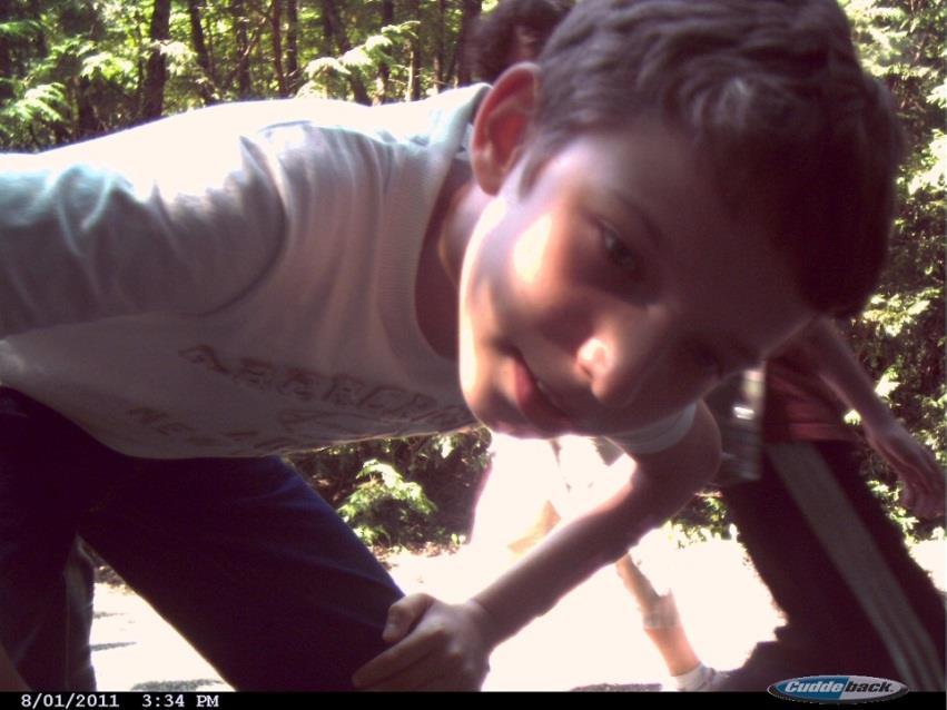
84 Monitoring - Trail Cam
 - requirements: Width min. (1m) & height (2.")

")
85 Integrated Accessibility Standard Regulation Sect (1) - requirements: Width min. (1m) & height (2.1m) Firm and stable surface Surface openings criteria Edge guard (5cm) at water or drop off Trail head signage length, surface type, avg. & min. trail width, avg. & max. running slope and cross slope, location of amenities (if provided) Consultation ( approval ) with Accessibility Advisory Committee on the specific criteria

, Hall Tract (2 km) 9km of shovel ready projects for implementation over next")
86 Building on Success 2012/13 Fall RFP for accessible trails based on our approved criteria: Design guidelines to address requirements of 2012 Integrated Accessibility Standard Detailed design for accessible trails in the; North Tract (2 km), Hollidge Tract (3 km), Eldred King Tract (2 km), Hall Tract (2 km) 9km of shovel ready projects for implementation over next 10 years

 never > 1:10 (10%) Running slope rec.1:20 (5%) never > 1:10 (10%) max.")
87 York Region Accessible Trail Guideline 2013 specifications approved by Accessibility Advisory Committee: Width 1.5m allows for turning Surface firm, stable (screenings) Cross slope recommended < 1:20 (5%) never > 1:10 (10%) Running slope rec.1:20 (5%) never > 1:10 (10%) max. & resting places Resting intervals and seating Others

 Reconstruction or new trails - not that")

88 Next Steps & Lessons Learned just completed construction of 2 km loop in North Tract Continued promotion of accessible trails tours, events - spread the word, Google pilot (street view) Reconstruction or new trails - not that complex, not that expensive 2015 new Forest Stewardship and Education Centre accessible facility and trail hub Personal and professional learning
89 Who benefits we all do INDIVIDUAL CULTURE URBAN FOREST COMMUNITY SOCIETY Become an Accessibility Champion!

90 In memory and gratitude to Margaret Gaukel accessibility advocate trail champion

91 Thank you questions? Regional Municipality of York Yonge Street, Newmarket, Ontario, Canada L3Y 6Z1
Committee. Presentation Outline
 CW-33-15 11/9/2015 Community and Corporate Services Committee November 10, 2015 1 Presentation Outline Background Vision and Objectives Study Process and Timeline Public and Stakeholder Engagement Organization
BACKCOUNTRY TRAIL FLOOD REHABILITATION PROGRAM
 BACKCOUNTRY TRAIL FLOOD REHABILITATION PROGRAM Backcountry Trail Flood Rehabilitation A June 2013 Flood Recovery Program Summary In June 2013, parts of Southern Alberta were devastated from significant
FILE: /PERM EFFECTIVE DATE: May 16, 2014 AMENDMENT:
 APPROVED AMENDMENTS: Effective Date Briefing Note /Approval Summary of Changes: FILE: 11000-00/PERM EFFECTIVE DATE: May 16, 2014 AMENDMENT: Table of Contents 1. POLICY APPLICATION... 1 2. PRINCIPLES AND
Brampton, Ontario REQ. no.: PLANNING, DESIGN & DEVELOPMENT COMMITTEE
 ftorontoand REGION rv~ Conservation for The Living City May 22,2009 2I22V,5L CFN 42397 CLERK S DEPT. Mr. Peter Fay City Clerk, City of Brampton MAY 2 7 2008 2 Wellington Street West Brampton, Ontario REQ.
FINCH HYDRO CORRIDOR TRAIL PROJECT
 FINCH HYDRO CORRIDOR TRAIL PROJECT Pharmacy Avenue to Birchmount Road January 29 th, 2018 L Amoreaux Community Centre (2000 McNicoll Avenue) 1 Purpose of Drop In Event The purpose of today s drop-in event
Strengthening the Ontario Trails Strategy. Report on Consultations and the Environmental Bill of Rights Registry
 Strengthening the Ontario Trails Strategy Report on Consultations and the Environmental Bill of Rights Registry Purpose To report on the feedback and information received through the regional consultations,
AODA MULTI-YEAR ACCESSIBILITY PLAN
 AODA MULTI-YEAR ACCESSIBILITY PLAN 2015-2019 Introduction Community Living Kincardine and District is committed to working towards full compliance with all standards under the Accessibility for Ontarians
STAFF REPORT ACTION REQUIRED
 STAFF REPORT ACTION REQUIRED 2015 Accessibility Plan Status Report Date: March 26, 2015 To: From: TTC Board Chief Executive Officer Summary This report describes, in detail, how the TTC is meeting, or
Proposed Action. Payette National Forest Over-Snow Grooming in Valley, Adams and Idaho Counties. United States Department of Agriculture
 United States Department of Agriculture Forest Service January 2012 Proposed Action Payette National Forest Over-Snow Grooming in Valley, Adams and Idaho Counties Payette National Forest Valley, Adams
China Creek North Park Upgrades and Glen Pump Station. Park Board Committee Meeting Monday, July 10, 2017
 China Creek North Park Upgrades and Glen Pump Station Park Board Committee Meeting Monday, July 10, 2017 Purpose The purpose of this presentation is to: Share the results of the public engagement processes;
Policy PL Date Issued February 10, 2014
 Subject RENEWABLE ENERGY ON CROWN LAND Compiled by Renewable Energy Program, Biodiversity Branch Replaces Policy Directives Waterpower Site Release Crown Land Onshore Windpower Development - Crown Land
Blueways: Rivers, lakes, or streams with public access for recreation that includes fishing, nature observation, and opportunities for boating.
 Parks, Open Space and Trails PRINCE WILLIAM COUNTY 2008 COMPREHENSIVE PLAN TRAILS PLAN CONTENTS The components of the trails plan are: Intent Definitions Goals, Policies, and Action Strategies Trails Map
DATE: 23 March, 2011 TO: Communities FROM: BlazeSports America. RE: Accessible Trails Checklist 1
 M E M O R A N D U M DATE: 23 March, 2011 TO: Communities FROM: BlazeSports America RE: Accessible Trails Checklist 1 The purpose of the Accessible Trails Checklist (below) is to help the community review
Chapter 6: POLICY AND PROCEDURE RECOMMENDATIONS
 Chapter 6 POLICY AND PROCEDURE RECOMMENDATIONS FOR SRRA Below are seven policy elements that should be considered for adoption by the Southwest Regional Recreation Authority of Virginia: 1. Develop strategies
Establishing a National Urban Park in the Rouge Valley
 STAFF REPORT ACTION REQUIRED Establishing a National Urban Park in the Rouge Valley Date: March 29, 2012 To: From: Wards: Reference Number: Executive Committee Deputy City Manager, Cluster B All p:\2012\cluster
Outdoor Developed Areas
 The United States Access Board is an independent federal agency that promotes equality for people with disabilities through leadership in accessible design and the development of accessibility guidelines
What s covered. What s not covered. Options for those not covered. ABA Coverage
 The United States Access Board is an independent federal agency that promotes equality for people with disabilities through leadership in accessible design and the development of accessibility guidelines
POLICY DCS-04: Tourism Directional Sign Policy. Development and Cultural Services
 DCS-04 Page 1 of 8 POLICY DCS-04: Tourism Directional Sign Policy Development and Cultural Services Approval Date: March 11, 2008 Approval Authority: Council, Resolution No. 7 Effective Date: March 11,
PROUDLY BRINGING YOU CANADA AT ITS BEST. Management Planning Program NEWSLETTER #1 OCTOBER, 2000
 PROUDLY BRINGING YOU CANADA AT ITS BEST VUNTUT NATIONAL PARK Management Planning Program NEWSLETTER #1 OCTOBER, 2000 INTRODUCTION This newsletter launches the development of the first management plan for
City of Durango 5.8 FUNDING TRAILS DEVELOPMENT
 5.8 FUNDING TRAILS DEVELOPMENT The City has been successful in establishing dedicated local funding sources as well as applying for grants to develop the City s trail system, having received nearly $2.4
Those with Interest in the City of Cambridge Trail System
 Community Services Department City Hall 50 Dickson Street, P.O. Box 669 Cambridge ON N1R 5W8 Tel: 519-740-4681 July 20, 2010 To: Re: Those with Interest in the City of Cambridge Trail System City of Cambridge
WASHINGTON STATE PARKS AND RECREATION COMMISSION POLICY/PROCEDURE
 WASHINGTON STATE PARKS AND RECREATION COMMISSION POLICY/PROCEDURE 65-13-1 Use of Other Power-Driven Mobility Devices by Persons with Mobility Disabilities at State Park Facilities See Also: 28 CFR 35 Title
Procedure for the Use of Power-Driven Mobility Devices on Mass Audubon Sanctuaries 1 September 17, 2012
 Procedure for the Use of Power-Driven Mobility Devices on Mass Audubon Sanctuaries 1 September 17, 2012 Background As part of Mass Audubon s mission to preserve the nature of Massachusetts for people and
White Mountain National Forest
 White Mountain National Forest United States Department of Agriculture Forest Service Eastern Region Boles Brook Snowmobile Bridge Decision Memo Boles Brook Snowmobile Bridge Project Town of Woodstock
Compliance Report. Halifax Stanfield International Airport. available in multiple formats
 Compliance Report Halifax Stanfield International Airport available in multiple formats This document and other Canadian Transportation Agency publications are available on our Web site at www.cta.gc.ca.
Welcome to the AccessibilityOnline Webinar Series. Listening to the Webinar. Listening to the Webinar, continued
 Welcome to the AccessibilityOnline Webinar Series A collaborative program between the ADA National Network and the U.S. Access Board The Session is Scheduled to begin at 2:30pm Eastern Time We will be
National Recreation Trail Application for Designation
 National Recreation Trail Application for Designation Introduction Thank you for your interest in the National Recreation Trail (NRT) program. Completed NRT application packages must be submitted by December
As outlined in the Tatshenshini-Alsek Park Management Agreement, park management will:
 Management Strategy General Strategy The priority management focus for the park is to ensure that its internationally significant natural, cultural heritage and recreational values are protected and that
MEETING DATE: February 17, 2010 SUBJECT: ACTION ITEM TORONTO TRANSIT COMMISSION REPORT NO. ACCESSIBLE TRANSIT SERVICES PLAN: 2009 STATUS REPORT
 TORONTO TRANSIT COMMISSION REPORT NO. MEETING DATE: February 17, 2010 SUBJECT: ACCESSIBLE TRANSIT SERVICES PLAN: 2009 STATUS REPORT ACTION ITEM RECOMMENDATION It is recommended that the Commission forward
TORONTO TRANSIT COMMISSION REPORT NO. SUBJECT: TORONTO-YORK SPADINA SUBWAY EXTENSION STATION NAMES IN THE CITY OF VAUGHAN
 TORONTO TRANSIT COMMISSION REPORT NO. MEETING DATE: February 29, 2011 SUBJECT: TORONTO-YORK SPADINA SUBWAY EXTENSION STATION NAMES IN THE CITY OF VAUGHAN ACTION ITEM RECOMMENDATIONS It is recommended that
Rouge Park Trail and Park Volunteers Orientation Package
 Rouge Park Trail and Park Volunteers Orientation Package In this package you will find: Welcome! Introduction to Rouge Park Introduction to the HAVE Program The Guided Walks and Ambassadors programs; part
2433 Dufferin Street Zoning By-law Amendment Application - Preliminary Report
 STAFF REPORT ACTION REQUIRED 2433 Dufferin Street Zoning By-law Amendment Application - Preliminary Report Date: July 22, 2014 To: From: Wards: Reference Number: North York Community Council Director,
Welcome to the future of Terwillegar Park a Unique Natural Park
 Welcome to the future of Terwillegar Park a Unique Natural Park 1 Introduction The Terwillegar Park Concept Plan study will develop an overall concept plan, management objectives and development guidelines
Bloor Street West Rezoning Application for a Temporary Use By-law Final Report
 STAFF REPORT ACTION REQUIRED 3741 3751 Bloor Street West Rezoning Application for a Temporary Use By-law Final Report Date: June 12, 2007 To: From: Wards: Reference Number: Etobicoke York Community Council
CITY OF WATERLOO ACCESSIBILITY STANDARDS. FINAL ACCESSIBILITY STANDARDS June 20, 2016
 CITY OF WATERLOO ACCESSIBILITY STANDARDS FINAL ACCESSIBILITY STANDARDS June 20, 2016 Waterloo City Centre 100 Regina Street South, Waterloo, ON N2J 4A8 P. 519.886.1550 F. 519.747.8760 TTY. 1.866.786.3941
Land Management Summary
 photo credit: ANGAIR Anglesea Heath Land Management Summary The Anglesea Heath (6,501 ha) was incorporated into the Great Otway National Park in January 2018. This provides an opportunity to consider the
SAULT COLLEGE SAULT STE. MARIE, ONTARIO COURSE OUTLINE
 SAULT COLLEGE SAULT STE. MARIE, ONTARIO COURSE OUTLINE COURSE TITLE: Trail Construction and Facility Maintenance CODE NO. : NRT 260 SEMESTER: 3 PROGRAM: AUTHOR: Adventure Recreation and Parks Brian Anstess
Members of the York Region Accessibility Advisory Committee. Accessibility Design Guidelines for York Regional Forest Trails
 Environmental Services Department Environmental Promotion and Protection Branch MEMORANDUM TO: FROM: Members of the York Region Accessibility Advisory Committee Ian Buchanan, Manager, Natural Heritage
Official Journal of the European Union L 337/43
 22.12.2005 Official Journal of the European Union L 337/43 PROTOCOL on the implementation of the Alpine Convention of 1991 in the field of tourism Tourism Protocol Preamble THE FEDERAL REPUBLIC OF GERMANY,
Preferred Recreation Recommendations Stemilt-Squilchuck Recreation Plan March 2018
 Preferred Recreation Recommendations Stemilt-Squilchuck Recreation Plan March 2018 Below are the recommended recreation ideas and strategies that package together the various recreation concepts compiled
EXECUTIVE SUMMARY PROGRAM DEVELOPMENT REPORT PURPOSE EXISTING SETTING EXPANDING PARKLAND
 EXECUTIVE SUMMARY PROGRAM DEVELOPMENT REPORT PURPOSE As the culmination of the first phase of the master planning process, this Program Development Report creates the framework to develop the Calero County
4.2 Regional Air Navigation/Safety Developments and Achievements. Group (NAM/CAR ANI/WG) INTEGRATION OF UNMANNED AIRCRAFT SYSTEMS (UAS)
 INTEGRATION OF UNMANNED AIRCRAFT SYSTEMS (UAS)") 03/05/16 Sixth Meeting of the North American, Central American and Caribbean Directors of Civil Aviation (NACC/DCA/06) Nassau, Bahamas, 10 12 May 2016 Agenda Item 4: Accountability Report of the ICAO NACC
03/05/16 Sixth Meeting of the North American, Central American and Caribbean Directors of Civil Aviation (NACC/DCA/06) Nassau, Bahamas, 10 12 May 2016 Agenda Item 4: Accountability Report of the ICAO NACC
visits4u Case Studies: Historical Centre of Athens Athens, Greece
 visits4u Case Studies: Historical Centre of Athens Athens, Greece Historical Centre of Athens Athens, Greece Title: The Historical Centre of Athens as an Accessible Destination Description Tourism in Greece
Tracy Ridge Shared Use Trails and Plan Amendment Project
 Tracy Ridge Shared Use Trails and Plan Amendment Project Scoping Document Forest Service Allegheny National Forest Bradford Ranger District McKean, County, Pennsylvania In accordance with Federal civil
[This page has been intentionally left blank]
![[This page has been intentionally left blank]](/thumbs/78/78754521.jpg "[This page has been intentionally left blank]") [This page has been intentionally left blank] Table of Contents Section Page Executive Summary... iii 1.0 Introduction... 1 1.1 Purpose... 1 1.2 Process... 1 1.3 Report Organization... 2 2.0 Existing Context...
[This page has been intentionally left blank] Table of Contents Section Page Executive Summary... iii 1.0 Introduction... 1 1.1 Purpose... 1 1.2 Process... 1 1.3 Report Organization... 2 2.0 Existing Context...
Biosphere Reserves of India : Complete Study Notes
 Biosphere Reserves of India : Complete Study Notes Author : Oliveboard Date : April 7, 2017 Biosphere reserves of India form an important topic for the UPSC CSE preparation. This blog post covers all important
Creating a User-Driven Long-Distance OHV Trail Through Partnering
 Joseph Raffaele Outdoor Recreation Planner U.S. Bureau of Land Management Yuma, Arizona Creating a User-Driven Long-Distance OHV Trail Through Partnering BLM is a multiple-use land management agency within
Criddle/Vane Homestead Provincial Park. Management Plan
 Criddle/Vane Homestead Provincial Park Management Plan 2 Criddle/Vane Homestead Provincial Park Table of Contents 1. Introduction... 3 2. Park History.... 3 3. Park Attributes.... 4 3.1 Natural.... 4 3.2
Ontario Trails Viewpoints and Information on the Ontario Trails Act Trailhead Ontario by Patrick Connor CAE June 7, 2015
 Ontario Trails Viewpoints and Information on the Ontario Trails Act 2015 Trailhead Ontario by Patrick Connor CAE June 7, 2015 Ontario Trails Council A provincial charitable organization Started in 1975
Flow Stand Up Paddle Board Parkway Plan Analysis
 Regional Parks Department Jeffrey R. Leatherman, Director County of Sacramento Divisions Administration Golf Leisure Services Maintenance Rangers Therapeutic Recreation Services Flow Stand Up Paddle Board
Mt. Hood National Forest
 United States Department of Agriculture Forest Service Mt. Hood National Forest Zigzag Ranger District 70220 E. Highway 26 Zigzag, OR 97049 503-622-3191 Fax: 503-622-5622 File Code: 1950-1 Date: June 29,
3.0 LEARNING FROM CHATHAM-KENT S CITIZENS
 3.0 LEARNING FROM CHATHAM-KENT S CITIZENS An important aspect in developing the Chatham-Kent Trails Master Plan was to obtain input from stakeholders and the general public. Throughout the course of the
County of Elgin Tourism Signage Policy Addendum A
 1.0 INTRODUCTION County of Elgin Tourism Signage Policy Addendum A 1.1 PURPOSE OF ELGIN TOURISM SIGNAGE POLICY To define the eligibility, use, design and authority for tourism oriented directional signage
Longmont to Boulder Regional Trail Jay Road Connection DRAFT FINAL REPORT
 Longmont to Boulder Regional Trail Jay Road Connection DRAFT FINAL REPORT December 2018 Project Summary Boulder County, Colorado, in partnership with the City of Boulder, is evaluating options for multi-use
Ouimet Canyon Provincial Nature Reserve. Management Plan
 Ouimet Canyon Provincial Nature Reserve Management Plan NOTE: This document has been scanned and formatted, and therefore is slightly different from the original version. -March 2002 Additional copies
TORONTO TRANSIT COMMISSION REPORT NO.
 Form Revised: February 2005 TORONTO TRANSIT COMMISSION REPORT NO. MEETING DATE: SUBJECT: Resubmitted December 19, 2012 November 21, 2012 MODERNIZING THE TTC A NEW APPROACH TO COMMUNICATIONS, COMMUNITY
What do they mean to you?
 CANADA S NEW GRADE CROSSING REGULATIONS What do they mean to you? May 2, 2015 Floris van Weelderen, P.Eng., PTOE Becky Lai, EIT THE ACCIDENTAL GRADE CROSSING Gare Montparnasse, Paris October 22, 1895 2
Sasagiu Rapids Provincial Park. Draft Management Plan
 Sasagiu Rapids Provincial Park Draft Management Plan 2 Sasagiu Rapids Provincial Park Table of Contents 1. Introduction... 3 2. Background and Park Attributes... 3 2.1 Park History.... 3 2.2 Natural Features...
MANAGEMENT DIRECTION STATEMENT June, 1999
 Thompson River District MANAGEMENT DIRECTION STATEMENT June, 1999 for Roche Lake Provincial Park Ministry of Environment Lands and Parks BC Parks Division Table of Contents I. Introduction A. Setting
Welcome to the AccessibilityOnline Webinar Series
 Welcome to the AccessibilityOnline Webinar Series A collaborative program between the ADA National Network and the U.S. Access Board The Session is Scheduled to begin at 2:30pm Eastern Time We will be
Provincial Railway Technical Standards
 GENERAL: INDEX: The standards and requirements listed in this document are intended for use on provincially regulated railway public grade crossings. These standards are considered the minimum requirements
TRAIL DATABASE SCHEMA (8/26/2014)
") Trail Data Model for LINES Source Data Source Agency dataagency Agency or entity that created the dataset where the original line was sourced from. Source Date of Last Data Used to Update sourcedate Publication
Trail Data Model for LINES Source Data Source Agency dataagency Agency or entity that created the dataset where the original line was sourced from. Source Date of Last Data Used to Update sourcedate Publication
4.0 Context for the Crossing Project
 4.0 Context for the Crossing Project This section provides background information about key features of the North Douglas Crossing project area, and opportunities and constraints. This information is important
Yard Creek Provincial Park. Management Plan
 Yard Creek Provincial Park Management Plan Draft January 2010 Yard Creek Provincial Park Management Plan Approved by: telàlsemkin/siyam/chief Scott Benton Bill Williams Squamish Executive Director ation
New ADA Accessibility Standards for the Attractions Industry
 New ADA Accessibility Standards for the Attractions Industry 1 New ADA Accessibility Standards for the Attractions Industry 2 INTERNATIONAL ASSOCIATION OF AMUSEMENT PARKS AND ATTRACTIONS WEBINAR DISCLAIMER
APPENDIX. Alberta Land Stewardship Act AMENDMENTS TO THE SOUTH SASKATCHEWAN REGIONAL PLAN
 APPENDIX Alberta Land Stewardship Act AMENDMENTS TO THE SOUTH SASKATCHEWAN REGIONAL PLAN 1 All references to Alberta Environment and Sustainable Resource Development, Environment and Sustainable Resource
2.08 AVALANCHE SEARCH AND RESCUE. Q: What is the process to provide feedback on the Interim Policy and Avalanche Safety Plan?
 2.08.1 RELATED DOCUMENTS 2.08 Avalanche Search and Rescue Policy 2.08 AVALANCHE SEARCH AND RESCUE 2.08.2 FREQUENTLY ASKED QUESTIONS AVALANCHE SAFETY PLANNING Q: Are SAR Groups required to develop their
Appendix A BC Provincial Parks System Goals
 Appendix A BC Provincial Parks System Goals The British Columbia Provincial Parks System has two mandates: To conserve significant and representative natural and cultural resources To provide a wide variety
National Recreation Trail Update Form
 National Recreation Trail Update Form Introduction Thank you for taking the time to complete this form. Your assistance will help ensure that the National Recreation Trail (NRT) database is complete and
Grade Crossing Regulations
 Grade Crossing Regulations An Overview of Municipal Roles and Responsibilities at Federally Legislated Grade Crossings March 21, 2017 presentation to Alberta Municipal Supervisor Association, Edmonton,
Dallas Fort Worth International Airport Concessions Pre-Proposal Conference
 Dallas Fort Worth International Airport Concessions Pre-Proposal Conference 7.30.2018 1 Webinar Protocol Expand/Collapse the Toolbar Full Screen Button Type Questions Here To see your webinar features,
TOURISM & PUBLIC SERVICES RURAL SIGNAGE POLICY
 Policy and Procedures Subject Title: Tourism and Public Services Rural Signage Policy Corporate Policy (Approved by Council): X Policy Ref. No.: ROADS-01-07 Administrative Policy (Approved by CAO): By-Law
Port Bruce. Interim Management Statement
 Port Bruce Interim Management Statement Port Bruce Interim Management Statement August 3, 1999 This Port Bruce Provincial Park Interim Management Statement provides direction for the custodial management
Regional Wayfinding Sign Strategy Thurston County Trails 2017
 Regional Wayfinding Sign Strategy Thurston County Trails 2017 Partners: Members and partnering organizations of the Thurston Thrives Community Design Action Team City of Lacey, City of Olympia, City of
Proposal to Redevelop Lower Kananaskis River-Barrier Lake. Bow Valley Provincial Park. Frequently Asked Questions
 Proposal to Redevelop Lower Kananaskis River-Barrier Lake Bow Valley Provincial Park Frequently Asked Questions What is being proposed? What are the details of the proposal? Where is the project area located?
Watchorn Provincial Park. Management Plan
 Watchorn Provincial Park Management Plan 2 Watchorn Provincial Park Table of Contents 1. Introduction... 3 2. Park History... 3 3. Park Attributes... 3 3.1 Natural... 4 3.2 Recreational... 4 3.3 Additional
communication tower means a tower or structure built to support equipment used to transmit communication signals;
 Ontario Ministry of Natural Resources Subject Communication Tower Sites on Crown Land Compiled by - Branch Lands & Waters Section Land Management Policy PL 4.10.02 Replaces Directive Title Communication
Group similar facilities together separate dissimilar facilities.
 Park design Principle #1 Group similar facilities together separate dissimilar facilities. Why do we do this? Safety Differences in admission fees Differences in seasonal use Reduce user conflicts Principle
The Vision for the San Juan Islands Scenic Byway
 The Vision for the San Juan Islands Scenic Byway 2 Judd Cove, Orcas Island, Courtesy of Kurt Thorson (kurtthorson.com) and San Juan County Land Bank Vision for the San Juan Islands Scenic Byway The San
Proposed Official Plan Amendment 41 to the Region of York Official Plan
 COMMITTEE OF THE WHOLE NOVEMBER 18, 2002 REGION OF YORK OFFICIAL PLAN AMENDMENT 41 THE OAK RIDGES MORAINE CONSERVATION PLAN Recommendation The Commissioner of Planning recommends: 1. That the City of Vaughan
Ministry of Parks, Culture and Sport. Plan for saskatchewan.ca
 Ministry of Parks, Culture and Sport Plan for 2018-19 saskatchewan.ca Table of Contents Statement from the Minister... 1 Response to Government Direction... 2 Operational Plan... 3 Highlights... 7 Financial
School Group Permits for Kananaskis Country Parks and Protected Areas-Memo
 Parks and Protected Areas School Group Permits for Parks and Protected Areas-Memo From: Date: January 4, 2005 Alberta Parks and Protected Areas Telephone: (403) 678-5508 To: All Alberta School Boards and
RE: Access Fund Comments on Yosemite National Park Wilderness Stewardship Plan, Preliminary Ideas and Concepts
 September 30, 2016 Superintendent Yosemite National Park Attn: Wilderness Stewardship Plan P.O. Box 577 Yosemite, CA 95389 RE: Access Fund Comments on Yosemite National Park Wilderness Stewardship Plan,
Clearwater Lake Provincial Park. Draft Management Plan
 Clearwater Lake Provincial Park Draft Management Plan Clearwater Lake Provincial Park Draft Management Plan Table of Contents 1. Introduction... 3 2. Park History... 4 3. Park Attributes... 4 3.1 Location/Access...4
MINISTRY OF TOURISM AND RECREATION
 THE ESTIMATES, 2005-06 1 SUMMARY The Ministry of Tourism and Recreation plays a central role in rebuilding the province's pride and economic prosperity. Its key activities directly support the achievement
Peter Axelson. Beneficial Designs, Inc. Minden, NV
 Peter Axelson Beneficial Designs, Inc. Minden, NV Arroya Sit Ski Mono Ski Dynamic Seating Spring Assist Cross Country Ski Hand Bike Adaptive Canoe Seating Available from Chosen Valley Canoe Accessories
A GUIDE TO MANITOBA PROTECTED AREAS & LANDS PROTECTION
 A GUIDE TO MANITOBA PROTECTED AREAS & LANDS PROTECTION Manitoba Wildands December 2008 Discussions about the establishment of protected lands need to be clear about the definition of protection. We will
Aspen Skiing Company Policy for Use of Other Power-Driven Mobility Devices And Service Animals
 Aspen Skiing Company Policy for Use of Other Power-Driven Mobility Devices And Service Animals Introduction New rules under the Americans with Disabilities Act (ADA), Titles II and III, went into effect
TWO NIGHT AGENDA. Wednesday Oct Big Ideas, Big Goals Who wants to eat the cake?
 TWO NIGHT AGENDA Wednesday Oct. 27 - Big Ideas, Big Goals Who wants to eat the cake? Survey and background info Case studies Promising projects Thursday Oct. 28 - Making it Real Who wants to help make
Lafourche Parish Government REQUEST FOR QUALIFICATIONS. Landscape Architectural Services
 Lafourche Parish Government REQUEST FOR QUALIFICATIONS Landscape Architectural Services Bayou Lafourche Parish Multi-Use Path Feasibility Study Phase 1 And Bayou Lafourche Parish Multi-Use Path Feasibility
Northern Rockies District Value of Tourism Research Project December 2007
 Northern Rockies District Value of Tourism Research Project December 2007 Project Partners: Northern Rockies Regional District, Tourism British Columbia, Northern Rockies Alaska Highway Tourism Association,
Design Considerations For Accessible Parks & Trails
 Design Considerations For Accessible Parks & Trails Measuring Up: Campbell River 2008 Dave Calver Consulting City of Campbell River Legacies Now: Measuring Up Design Guidelines Design Considerations for
Recreation Management Plan Lake Baroon and Ewen Maddock Dam
 Lake Baroon and Ewen Maddock Dam December 2013 Contents Overview... 3 The Value of Our Natural Areas... 4 Management Approach... 6 Funding... 7 Recreation Management... 8 Conditions of Access and Use...
Proposal to Redevelop Lower Kananaskis River-Barrier Lake. Bow Valley Provincial Park
 Frequently Asked Questions Proposal to Redevelop Lower Kananaskis River-Barrier Lake Bow Valley Provincial Park Frequently Asked Questions What has been decided? What are the details of the plan? What
URBAN DESIGN REPORT. Proposed Residential Development, Old Church Road, Caledon East
 Proposed Residential Development, Old Church Road, Caledon East TABLE CONTENTS: 1.0 DEVELOPMENT 1.1 Introduction-Analysis of Guiding Principles and Documents 1.2 Community Design and Architectural Design
Minimum Requirements References in National Park Service Policy
 Minimum Requirements References in National Park Service Policy 2006 NPS Management Policies Chapter 6: Wilderness Preservation and Management 6.3 Wilderness Resource Management 6.3.1 General Policy (in
Civil and military integration in the same workspace
 Civil and military integration in the same workspace Presented by PLC 1 introduction Civilian and Military ATCOs work alongside each other in various countries and are employed in a number of different
PROPOSAL FOR RECLASSIFICATION, BOUNDARY AMENDMENT AND DRAFT CONCEPT PLAN FOR SASKATOON MOUNTAIN NATURAL AREA. Frequently Asked Questions
 PROPOSAL FOR RECLASSIFICATION, BOUNDARY AMENDMENT AND DRAFT CONCEPT PLAN FOR SASKATOON MOUNTAIN NATURAL AREA 1. Why is this proposal being put forward? Frequently Asked Questions For many years, Alberta
SUSTAINING OUR ENVIRONMENT, PLANNING FOR OUR FUTURE
 SUSTAINING OUR ENVIRONMENT, PLANNING FOR OUR FUTURE Key Recommendations to Inform the 2015 Provincial Review of the Oak Ridges Moraine Conservation Plan APRIL 2015 KEY RECOMMENDATIONS TO INFORM THE 2015
Continental Divide National Scenic Trail Legislative History and Planning Guidance
 Continental Divide National Scenic Trail Legislative History and Planning Guidance Legislation, Policy, and Direction Regarding National Scenic Trails The National Trails System Act, P.L. 90-543, was passed